
Integrated Watershed Management Framework and Groundwater Resources in Africa—A Review of West Africa Sub-Region


Abstract
:1. Introduction
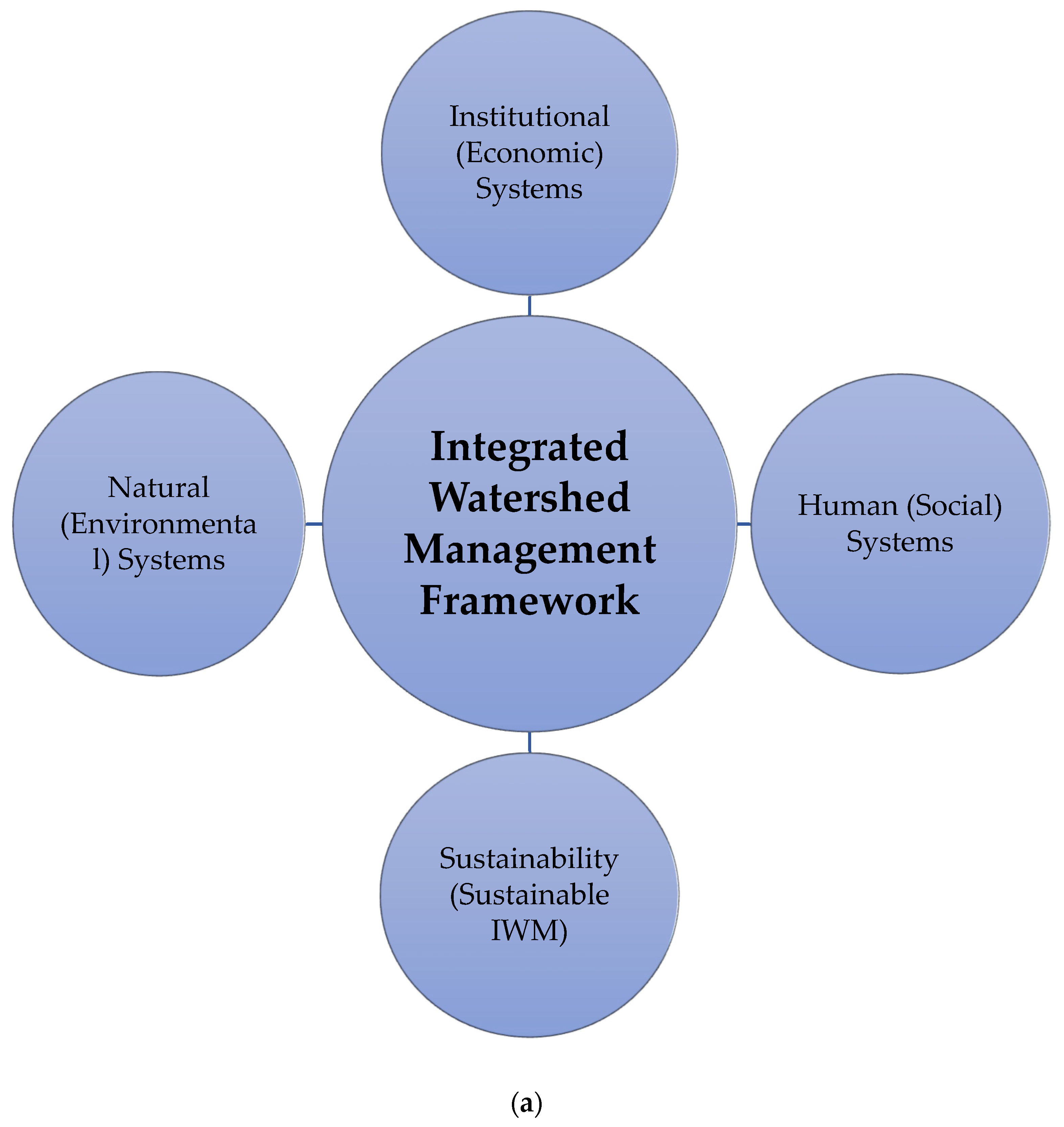
2. Watershed Management in Africa
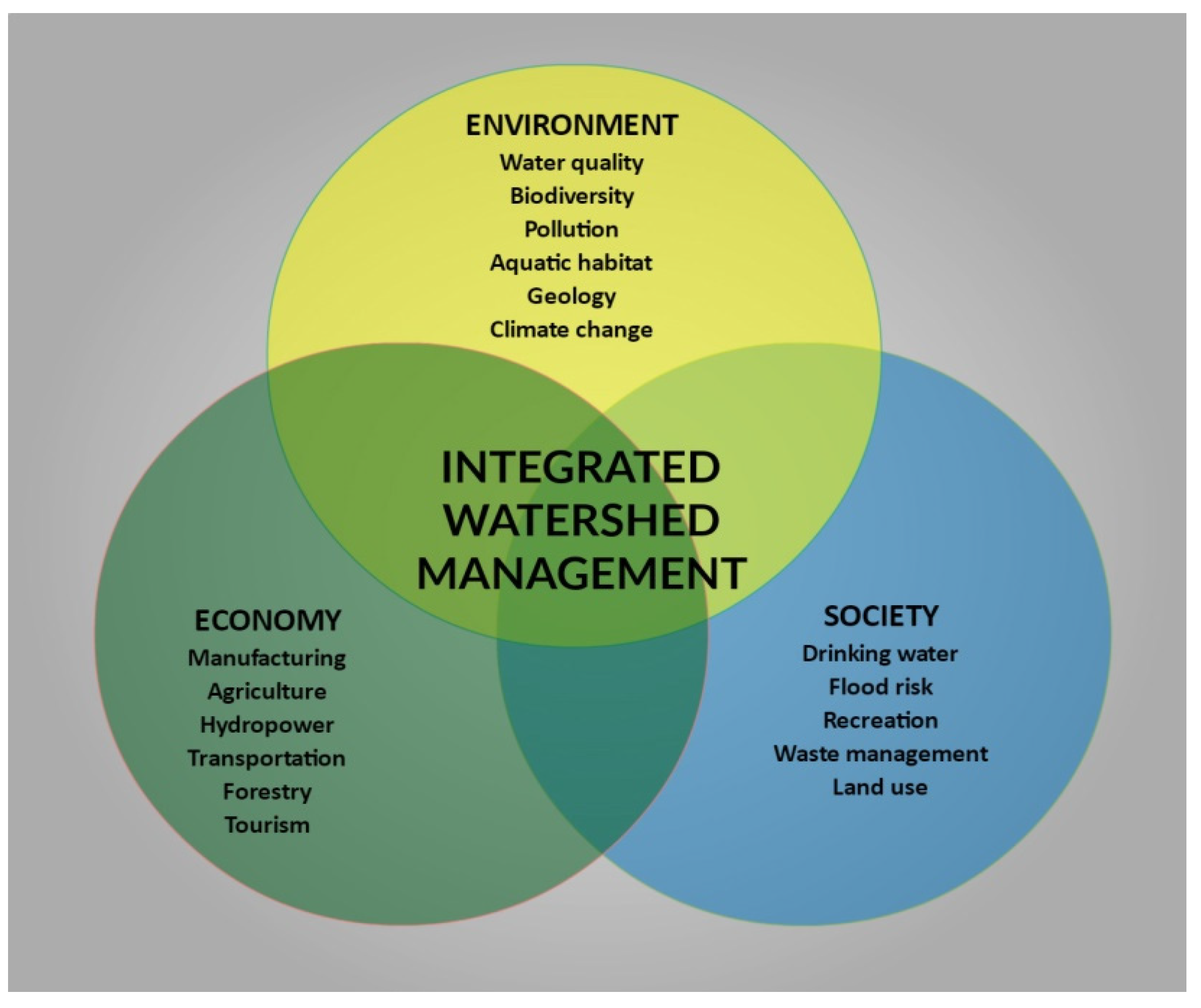
Why Are Watershed and Groundwater Resources Important?
3. Methods
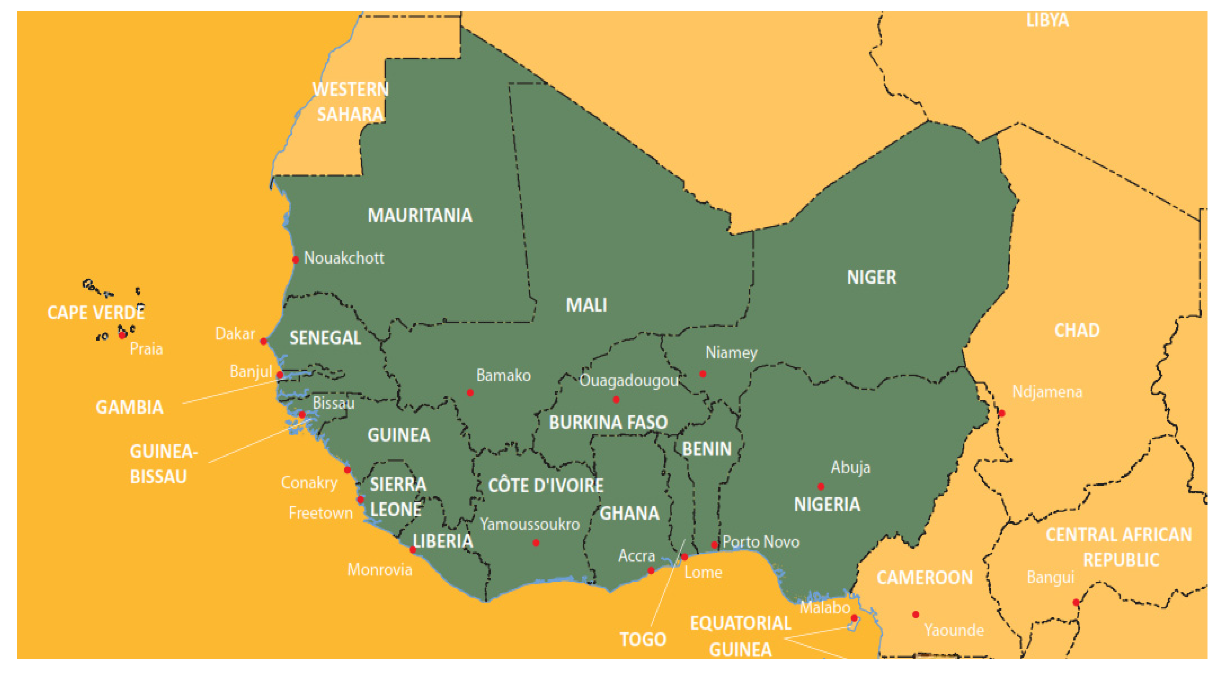
Study Area: Africa (West Africa)
4. Discussion
What Are the Watershed and Groundwater Resources Management Issues?
5. Conclusions
- Create a framework for simplifying and building synergies between national, regional, and intercontinental activities aimed at maximizing the effectiveness and sustainability of Africa’s existing waterways and natural resources;
- Slowing the rate of urbanization and population increase near river basins; c. Water infrastructure investment using contemporary technologies;
- Experts and human resources providing up-to-date data to counteract misuse;
- Cooperation among nations sharing water basins and strict adherence by all African countries that are signatories to the 1997 United Nations Convention on non-navigational and transboundary uses of international watercourses.
Author Contributions
Funding
Institutional Review Board Statement
Informed Consent Statement
Data Availability Statement
Acknowledgments
Conflicts of Interest
References
- Patle, D.; Rao, J.H.; Dubey, S. Morphometric analysis and prioritization of sub-watersheds in Nahra watershed of Balaghat district, Madhya Pradesh: A remote sensing and GIS perspective. J. Exp. Biol. Agric. Sci. 2020, 8, 447–455. [Google Scholar] [CrossRef]
- Glossary of Terms for Negotiators of Multilateral Environmental Agreements, Division of Environmental Law and Conventions, United Nations Environment Programme, UNEP/Earth Print. 2007. Available online: https://www.unep.org/resources/report/glossary-terms-negotiators-multilateral-environmental-agreements (accessed on 1 December 2021).
- Heathcote, I.W. Integrated Watershed Management: Principles and Practice; John Wiley & Sons: Hoboken, NJ, USA, 2009; ISBN 978-0-470-37625-6. Available online: https://www.osti.gov/biblio/298224-integrated-watershed-management-principles-practice (accessed on 1 December 2021).
- Pavelic, P.; Brindha, K.; Amarnath, G.; Eriyagama, N.; Muthuwatta, L.; Smakhtin, V.; Kant, L. Controlling Floods and Droughts through Underground Storage: From Concept to Pilot Implementation in the Ganges River Basin; International Water Management Institute (IWMI): Gujarat, India, 2015; Volume 165, Available online: https://www.dadoslivres.com/telecharger/controlling-floods-and-droughts-through-underground-storage-from-concept-to-pilot-implementation-in-the-ganges-river-basin/ (accessed on 1 December 2021).
- Verry, E.S.; Hornbeck, J.W.; Dolloff, C.A. Riparian Management in Forests of the Continental Eastern United States; Lewis Publishers: Boca Raton, FL, USA, 1999; pp. 125–138. Available online: https://www.fs.usda.gov/treesearch/pubs/9428 (accessed on 1 December 2021).
- Sharma, N.; Zakaullah, M.; Tiwari, H.; Kumar, D. Runoff and sediment yield modelling using ANN and support vector machines: A case study from Nepal watershed. Model. Earth Syst. Environ. 2015, 1, 23. [Google Scholar] [CrossRef] [Green Version]
- Sharma, T. Watershed Management and policies in India. Int. J. Res.-Granthaalayah 2015, 3, 1–4. [Google Scholar]
- Willems, P.; Olsson, J.; Arnbjerg-Nielsen, K.; Beecham, S.; Pathirana, A.; Bülow Gregersen, I.; Eng, S.J.A.P. African Development Bank’s Experience Following Nexus Approach–Case Studies in Integrated Watershed Management to achieve Food Security and Sustainable Natural Resources Management from the Republic of Cape Verde, Burundi, and the Gambia. In Proceedings of the International Kick-Off Workshop, 11–12 November 2013; Technical University Dresden: Dresden, Germany, 2013; pp. 121–143. Available online: https://collections.unu.edu/eserv/UNU:2692/Proceedings_KickOffWorkshopNexusApproach.pdf (accessed on 1 December 2021).
- Medema, W.; McIntosh, B.S.; Jeffrey, P.J. From premise to practise: A critical assessment of integrated water resources management and adaptive management approaches in the water sector. Ecol. Soc. 2008, 13, 29. [Google Scholar] [CrossRef] [Green Version]
- Ravindranath, N.H.; Sathaye, J.A. Climate Change and Developing Countries. In Climate Change and Developing Countries; Springer: Dordrecht, The Netherlands, 2002; pp. 247–265. Available online: https://www.coursehero.com/tutors-problems/Business-Other/34242542-Hi-can-you-give-me-9-scholarly-articles-to-read-so-I-can-answer// (accessed on 1 December 2021).
- Conservation Ontario. Overview of Integrated Watershed Management in Ontario; Conservation Ontario: Newmarket, ON, Canada, 2010. [Google Scholar]
- Jamtsho, K.; Gyamtsho, T. Effective Watershed and Water Management at the Local Level: Challenges and Opportunities; International Development and Research Council: Ottawa, ON, Canada, 2003; Available online: https://idl-bnc-idrc.dspacedirect.org/handle/10625/29436 (accessed on 1 December 2021).
- Bureau, R. Watershed management research: A review of IDRC projects in Asia and Latin America. In Rural Poverty and Environment Working Paper Series; International Development and Research Council: Ottawa, ON, Canada, 2005; no. 18; Available online: https://idl-bnc-idrc.dspacedirect.org/handle/10625/25832 (accessed on 1 December 2021).
- World Bank. World Development Report 2008: Agriculture for Development, the World Bank. 2007. Available online: www.elibrary.worldbank.org (accessed on 1 December 2021).
- Rockström, J.; Falkenmark, M. Agriculture: Increase water harvesting in Africa. Nature 2015, 519, 283–285. [Google Scholar] [CrossRef]
- Akudugu, M.A.; Dittoh, S.; Mahama, E.S. The implications of climate change on food security and rural livelihoods: Experiences from Northern Ghana. J. Environ. Earth Sci. 2012, 2, 21–29. [Google Scholar]
- Namara, R.E.; Horowitz, L.; Nyamadi, B.; Barry, B. Irrigation Development in Ghana: Past Experiences, Emerging Opportunities, and Future Directions. 2011. Available online: https://reliefweb.int/sites/reliefweb.int/files/resources/Full_Report_228.pdf (accessed on 1 December 2021).
- Seddon, D.; Kashaigili, J.J.; Taylor, R.G.; Cuthbert, M.O.; Mwihumbo, C.; MacDonald, A.M. Focused groundwater recharge in tropical dryland: Empirical evidence from central, semi-arid Tanzania. J. Hydrol. Reg. Stud. 2021, 37, 100919. [Google Scholar] [CrossRef]
- Rockström, J.; Falkenmark, M.; Karlberg, L.; Hoff, H.; Rost, S.; Gerten, D. Future water availability for global food production: The potential of green water for increasing resilience to global change. Water Resour. Res. 2009, 45, 2–16. [Google Scholar] [CrossRef] [Green Version]
- Aduah, M.S.; Jewitt, G.P.W.; Toucher, M.L.W. Assessing Impacts of Land Use Changes on the Hydrology of a Lowland Rainforest Catchment in Ghana, West Africa. Water 2018, 10, 9. [Google Scholar] [CrossRef] [Green Version]
- Connor, R. The United Nations World Water Development Report 2015: Water for a Sustainable World; UNESCO Publishing: Paris, France, 2015; Volume 1, Available online: https://unesdoc.unesco.org/ark:/48223/pf0000231823 (accessed on 1 December 2021).
- Black, M. The Atlas of Water: Mapping the World’s Most Critical Resource; Univ of California Press: Oakland, CA, USA, 2016. [Google Scholar]
- Ntiba, M.J.; Kudoja, W.M.; Mukasa, C.T. Management issues in the Lake Victoria watershed. Lakes Reserv. Res. Manag. 2001, 6, 211–216. Available online: https://eijst.org.uk/articles/10.2.2.13-28.pdf (accessed on 1 December 2021). [CrossRef] [Green Version]
- Le Coz, M.; Delclaux, F.; Genthon, P.; Favreau, G. Assessment of Digital Elevation Model (DEM) aggregation methods for hydrological modelling: Lake Chad basin, Africa. Comput. Geosci. 2009, 35, 1661–1670. [Google Scholar] [CrossRef]
- Lemoalle, J. Lake Chad: A changing environment. In Dying and Dead Seas Climatic Versus Anthropic Causes; Springer: Dordrecht, The Netherlands, 2014; pp. 321–339. [Google Scholar] [CrossRef]
- UNEP, W. Freshwater under Threat: Vulnerability Assessment of Freshwater Resources to Environmental Change–Africa. UNEP and Water Research Commission (WRC-South Africa). 2008. Available online: https://www.unep.org/resources/report/freshwater-under-threat-vulnerability-assessment-freshwater-resources (accessed on 1 December 2021).
- United Nations Environment Programme. Africa Water Atlas, Division of Early Warning and Assessment; UNEP/Earth Print: Nairobi, Kenya, 2010; Volume 1, Available online: https://na.unep.net/atlas/africawater/downloads/chapters/africa_water_atlas_37-122.pdf (accessed on 1 December 2021).
- FAO. The Provisional Agenda (Document C97/1) includes Technical, Program, Administrative, and Constitutional Items; Food and Agriculture Organization: Rome, Italy, 2006; Available online: https://www.fao.org/3/a0800e/A0800E.pdf (accessed on 1 December 2021).
- Robins, L. Nation-wide decentralized governance arrangements and capacities for integrated watershed management: Issues and insights from Canada. Environments 2007, 35, 1–17. [Google Scholar]
- Beaumont, P. The 1997 UN Convention on the Law of Non-navigational Uses of International Watercourses: Its Strengths and Weaknesses from a Water Management Perspective and the Need for New Workable Guidelines. Int. J. Water Resour. Dev. 2000, 16, 475–495. [Google Scholar] [CrossRef]
- Katusiime, J.; Schütt, B. Linking Land Tenure and Integrated Watershed Management—A Review. Sustainability 2020, 12, 1667. [Google Scholar] [CrossRef] [Green Version]
- Mengistu, F.; Assefa, E. Towards sustaining watershed management practices in Ethiopia: A synthesis of local perception, community participation, adoption and livelihoods. Environ. Sci. Policy 2020, 112, 414–430. [Google Scholar] [CrossRef]
- Huang, Z.; Nya, E.L.; Rahman, M.A.; Mwamila, T.B.; Cao, V.; Gwenzi, W.; Noubactep, C. Integrated Water Resource Management: Rethinking the Contribution of Rainwater Harvesting. Sustainability 2021, 13, 8338. [Google Scholar] [CrossRef]
- Liang, X.; Liang, Y.; Chen, C.; Van Dijk, M.P. Implementing water policies in China: A policy cycle analysis of the sponge city program using two case studies. Sustainability 2020, 12, 5261. [Google Scholar] [CrossRef]
- Musayev, S.; Burgess, E.; Mellor, J. A global performance assessment of rainwater harvesting under climate change. Resour. Conserv. Recycl. 2018, 132, 62–70. [Google Scholar] [CrossRef]
- Nakawuka, P.; Langan, S.; Schmitter, P.; Barron, J. A review of trends, constraints and opportunities of smallholder irrigation in East Africa. Glob. Food Secur. 2018, 17, 196–212. [Google Scholar] [CrossRef]
- Partey, S.; Zougmoré, R.B.; Ouédraogo, M.; Campbell, B.M. Developing climate-smart agriculture to face climate variability in West Africa: Challenges and lessons learnt. J. Clean. Prod. 2018, 187, 285–295. [Google Scholar] [CrossRef]
- Kim, D.-G.; Grieco, E.; Bombelli, A.; Hickman, J.E.; Sanz-Cobena, A. Challenges and opportunities for enhancing food security and greenhouse gas mitigation in smallholder farming in sub-Saharan Africa. A review. Food Secur. 2021, 13, 457–476. [Google Scholar] [CrossRef]
- Acuña-Alonso, C.; Fernandes, A.C.P.; Álvarez, X.; Valero, E.; Pacheco, F.A.L.; Varandas, S.D.G.P.; Daniela, P.S.T.; Fernandes, L.F.S. Water security and watershed management assessed through the modelling of hydrology and ecological integrity: A study in the Galicia-Costa (NW Spain). Sci. Total Environ. 2021, 759, 143905. [Google Scholar] [CrossRef]
- Schuol, J.; Abbaspour, K.C.; Srinivasan, R.; Yang, H. Estimation of freshwater availability in the West African sub-continent using the SWAT hydrologic model. J. Hydrol. 2008, 352, 30–49. [Google Scholar] [CrossRef]
- Kuma, H.G.; Feyessa, F.F.; Demissie, T.A. Hydrologic responses to climate and land-use/land-cover changes in the Bilate catchment, Southern Ethiopia. J. Water Clim. Chang. 2021, 12, 3750–3769. [Google Scholar] [CrossRef]
- Jaiswal, R.K.; Lohani, A.K.; Tiwari, H.L. A Decision Support System Framework for strategic water resources planning and management under projected climate scenarios for a Reservoir Complex. J. Hydrol. 2021, 603, 127051. [Google Scholar] [CrossRef]


| Physical & Environmental Factors | Characteristics |
|---|---|
| Biophysical System | Natural biophysical units such as watersheds/catchments and river basins are useful for monitoring natural processes. |
| Multiple Scales | Watersheds/catchments and river basins establish distinct nested landscape hierarchies that emphasize biophysical interdependence at large numbers. |
| Process Investigations | Large scale, input-output, and irrigation analyses, as well as cause-and-effect interactions, may all be analyzed using watersheds and river basins. |
| Integrated Framework | Watersheds take into account all land-use consequences and emphasize the connections between land use and other natural systems. |
| Assist in Addressing Complexity | Its cumulative impacts can be studied, and interactions between the atmosphere, soil, and water can be determined. |
| Socio-cultural Factors | |
| Tool for Making Scientific Decisions | Watersheds make scientific judgements easier since they are geological divisions. These serve as a stable platform for complex and adaptable governance. |
| Links Across Borders | Watersheds are defined by watercourses, which comprise interconnected natural resources. This unites countries and regions by inland flow and continuing occurrence across stream borders. |
| Social Organization | As a result of their social construction, watersheds may serve as a communal gathering spot for dialogue, settlement, management, and observation. |
| Key Locations | Images of the Major River Basins in Africa | Position within Africa’s Worldview | Remarks |
|---|---|---|---|
| Congo River Basin |  |  | The Congo Basin is a massive 3,900,000 km depression that stretches almost 2200 km north-east and south-west. It stretches across the globe and accumulates a lot of rain, which falls on the tropical rainforests that cover a large portion of its area. |
| Juba Shabelle Basin |  |  | Both the Juba and the Shabelle hail from the southern Ethiopian Highlands, which are about 3000 mm above sea level. Despite its small drainage basin, the Juba receives more rain and has significantly greater runoff around in its sources. |
| Lake Chad Basin |  |  | The Chad Basin watershed region is shared by eight countries: Algeria, Cameroon, Central African Republic, Chad, Libya, Niger, Nigeria, and Sudan. It encompasses a little over 8% of Africa’s land area. |
| Lake Turkana Basin |  |  | Even though the Lake Turkana Basin spans four nations, just two of them account for approximately 95% of its total area. Ethiopia, which receives about three-quarters of the basin’s rainfall, accounts for more than half (50–54%). |
| Limpopo River Basin |  |  | The mostly semi-arid Limpopo River watershed receives the majority of its precipitation during a brief, strong rainy season in the austral summer (December–February). Rainfall varies greatly throughout the year and across seasons, rendering the basin vulnerable to severe drought and flooding. |
| Niger River Basin |  |  | The Niger River originates in eastern Guinea’s Fouta Djallon mountains and Côte d’Ivoire’s extreme northwestern corner. The mean annual precipitation is the heaviest in the basin, with 1635 mm/year in Guinea and 1466 mm/year in Côte d’Ivoire [27]. |
| Nile River Basin |  |  | In northern Burundi, the Nile begins its 6800 km trek to the sea at 1600 m above sea level. The Mara, Nzoia, Katonga, Kagera, Yala, Isanga, Sondu, Ruizi, Kibos, Simiyu, and Sio are among the many rivers that pour into Lake Victoria; however, only the Victoria Nile flows out. |
| Ogooué River Basin |  |  | The Ogooué River rises near Gabon’s border at a relatively low height. Approximately 85% of the basin is located in Gabon, with the remaining 12% in Congo and Cameroon, and Equatorial Guinea. A thick network of perennial streams feeds the river. |
| Okavango Delta Makgadikgadi Basin |  |  | The Okavango Delta Basin is a sub-catchment of the larger Makgadikgadi Salt Pans drainage basin. However, the pans are only flooded periodically, and the Okavango system contains the majority of the basin’s water supplies. |
| Orange River Basin |  |  | The Orange River begins high in the Drakensberg Mountains in Lesotho, where its tributary, the Senqu, begins. Despite accounting for only 3% of the basin, Lesotho’s mountains get some of the greatest mean annual rainfall in the basin, and Lesotho supplies almost 17% of the Orange River’s water budget. |
| Senegal River Basin |  |  | The Bafing and Bakoye Rivers, both of which originate in the Guinea Highlands, are the Senegal River’s two main tributaries. The Bafi River, which starts at 800 m in the Fouta Djallon, is the source of the majority of Senegal’s flow. The Bakoye originates around 250 km to the east, on the Manding Plateau. |
| Volta River Basin |  |  | The Volta Basin spans sections of six West African countries. Burkina Faso and Ghana account for around 40% of the basin’s total area. Togo accounts for 8% of the total, while Benin, Côte d’Ivoire, and Mali account for the remaining 12%. |
| Zambezi River Basin |  |  | The Zambezi River flows at roughly 1500 m above sea level in the Kalene Hills, where the boundaries of eastern Angola, northern Zambia, and southern DRC meet. As it passes through Angola and northern Zambia, the topography is dominated by miombo woodlands with channels of grassland swamps across drainage channels and river system woodlands along larger creeks. |
| Country | Total Surface Area km2 (ha) | Average Precipitation in-Depth (mm/year) | Water Resource and Watershed Management Challenges |
|---|---|---|---|
| The Federal Republic of Nigeria | 923,768 km2 91,077 ha | 1150 | Fadama regions, which are low-lying areas inundated during the rainy season, are found throughout most of the nation, including the Guinea Savannah, Sudan Savannah, and Sahel natural zones. |
| The Islamic Republic of Mauritania | 1,025,520 km2 (102,522 ha) | 92 | Since Mauritania is surrounded by deserts and experiences periodic droughts, water is inherently scarce. The building of two new dams on the Senegal River has aided the fast expansion of Mauritania’s irrigated agriculture sector. |
| Republic of Benin | 112,622 km2 (11,063 ha) | 1039 | Water resources are unevenly allocated both geographically and through time, although enough water is available for present and future requirements. |
| Burkina Faso | 274,000 km2 (27,360 ha) | 748 | Burkina Faso is located in the Sahel, where droughts and floods are becoming increasingly frequent and severe. Rain-fed agriculture is being phased out, and people are flocking to peri-urban regions. |
| Republic of Cabo Verde | 4033 km2 (433 ha) | 228 | Cape Verde has limited rainfall and is subject to severe droughts on occasion, limiting water supplies. Aquifers along the shore have been overexploited, resulting in well seawater intrusion. |
| Republic of Côte d’Ivoire | 322,463 km2 (31,800 ha) | 1348 | Chemical waste from agricultural, industrial, and mining sources has resulted in considerable water contamination in Côte d’Ivoire. |
| Republic of Ghana | 238,553 km2 (22,754 ha) | 1187 | In Ghana, water reforms have made significant progress, increasing from about 54% in 1990 to 80% in 2008. |
| Republic of Guinea | 245,857 km2 (24,572 ha) | 1651 | Guinea is one of the wettest countries in West Africa, yet water treatment plants regularly fail, leaving the country without flowing water for weeks. |
| Republic of Guinea-Bissau | 36,125 km2 (3612 ha) | 1577 | The water and sanitation infrastructure of Guinea-Bissau is among the worst in the world. The bulk of the population relies on shallow wells, which are frequently polluted by sanitary facilities nearby. |
| Republic of Liberia | 111,369 km2 (11,137 ha) | 2391 | The nearby wetlands are a valuable resource for the community. Residents of Liberia have complained of diarrhoea as a result of drinking the water. |
| Republic of Mali | 1,240,192 km2 (122,019 ha) | 282 | Droughts and desertification are becoming more of a danger to Mali’s ecosystems and livelihoods. Mali is a landlocked country in western Africa. |
| Republic of Niger | 1,267,000 km2 (126,670 ha) | 151 | Only a small fraction of Niger’s land is arable due to its dry environment and the fact that close to 65%of its area is within the Sahara desert. |
| Republic of Senegal | 196,722 km2 19,252 ha | 686 | Guinea, Mali, Mauritania, and Senegal are all riparian nations along the 1800 km Senegal River. Dam development, on the other hand, has put this crucial ecosystem in jeopardy, resulting in environmental deterioration and detrimental effects on residents’ health. |
| Republic of Sierra Leone | 71,740 km2 (7162 ha) | 2526 | Notwithstanding the economic benefits, hydropower expansion frequently puts riparian populations’ homes and livelihoods at risk. |
| Republic of The Gambia | 11,295 km2 (1290 ha) | 836 | Gambia’s whole nation sits within the Gambia River’s drainage basin, which has a highly seasonal flow. The salinity of the ocean has an impact on Gambia’s lowlands, which has a significant impact on the country’s flora and water consumption. |
| Togolese Republic | 56,785 km2 (5439 ha) | 1168 | Togo is vulnerable to sea-level rises due to its relatively flat geography and large coastline zone (1710 km). |
| Total | (6,138,044 km2) 733,359 ha | 17,060 mm/year |
| Countries | Municipal | Industrial | Agricultural | Remarks |
|---|---|---|---|---|
| Federal Republic of Nigeria | 21.1% | 10.1% | 68.8% | Generally adequate for agricultural purposes |
| Islamic Republic of Mauritania | 8.9% | 2.9% | 88.2% | Generally adequate for agricultural purposes |
| Republic of Benin | 31.5% | 23.1% | 45.4% | Generally inadequate for agricultural purposes |
| Burkina Faso | 13% | 0.8% | 86.2% | Generally adequate for agricultural purposes |
| Republic of Cabo Verde | 7.3% | 1.8% | 90.9% | Generally adequate for agricultural purposes |
| Republic of Côte d’Ivoire | 23.7% | 11.4% | 64.5% | Fairly adequate for agricultural purposes |
| Republic of Ghana | 23.9% | 9.7% | 66.4% | Fairly adequate for agricultural purposes |
| Republic of Guinea | 7.9% | 1.9% | 90.1% | Generally adequate for agricultural purposes |
| Republic of Guinea-Bissau | 13.1% | 4.6% | 82.3% | Generally adequate for agricultural purposes |
| Republic of Liberia | 27.2% | 18.2% | 54.6% | Fairly adequate for agricultural purposes |
| Republic of Mali | 9% | 0.9% | 90.1% | Generally adequate for agricultural purposes |
| Republic of Niger | 4.1% | 0.5% | 95.4% | Generally adequate for agricultural purposes |
| Republic of Senegal | 4.5% | 2.6% | 92.9% | Generally adequate for agricultural purposes |
| Republic of Sierra Leone | 5.3% | 2.6% | 92.1% | Generally adequate for agricultural purposes |
| Republic of The Gambia | 22.9% | 11.8% | 65.3% | Fairly adequate for agricultural purposes |
| Togolese Republic | 52.7% | 2.4% | 44.9% | Generally inadequate for agricultural purposes. |
| Key Issues | Impacts on the Management of the Watersheds |
|---|---|
| Finance |
|
| Lack of Data and Human Capacity |
|
| Inadequate Access to Water for Various Purposes |
|
| Loss of Ecological Habitats and Loss of Biodiversity | Some of the harmful repercussions of poorly constructed and maintained water resources infrastructures are as follows:
|
Publisher’s Note: MDPI stays neutral with regard to jurisdictional claims in published maps and institutional affiliations. |
© 2022 by the authors. Licensee MDPI, Basel, Switzerland. This article is an open access article distributed under the terms and conditions of the Creative Commons Attribution (CC BY) license (https://creativecommons.org/licenses/by/4.0/).
Share and Cite
Tang, X.; Adesina, J.A. Integrated Watershed Management Framework and Groundwater Resources in Africa—A Review of West Africa Sub-Region. Water 2022, 14, 288. https://doi.org/10.3390/w14030288
Tang X, Adesina JA. Integrated Watershed Management Framework and Groundwater Resources in Africa—A Review of West Africa Sub-Region. Water. 2022; 14(3):288. https://doi.org/10.3390/w14030288
Chicago/Turabian StyleTang, Xiaolan, and John Adekunle Adesina. 2022. "Integrated Watershed Management Framework and Groundwater Resources in Africa—A Review of West Africa Sub-Region" Water 14, no. 3: 288. https://doi.org/10.3390/w14030288
APA StyleTang, X., & Adesina, J. A. (2022). Integrated Watershed Management Framework and Groundwater Resources in Africa—A Review of West Africa Sub-Region. Water, 14(3), 288. https://doi.org/10.3390/w14030288