A Tale of Shaheen’s Cyclone Consequences in Al Khaboura City, Oman
Abstract
:1. Introduction
2. Materials and Methods
2.1. Study Area
2.2. Model and Input Data
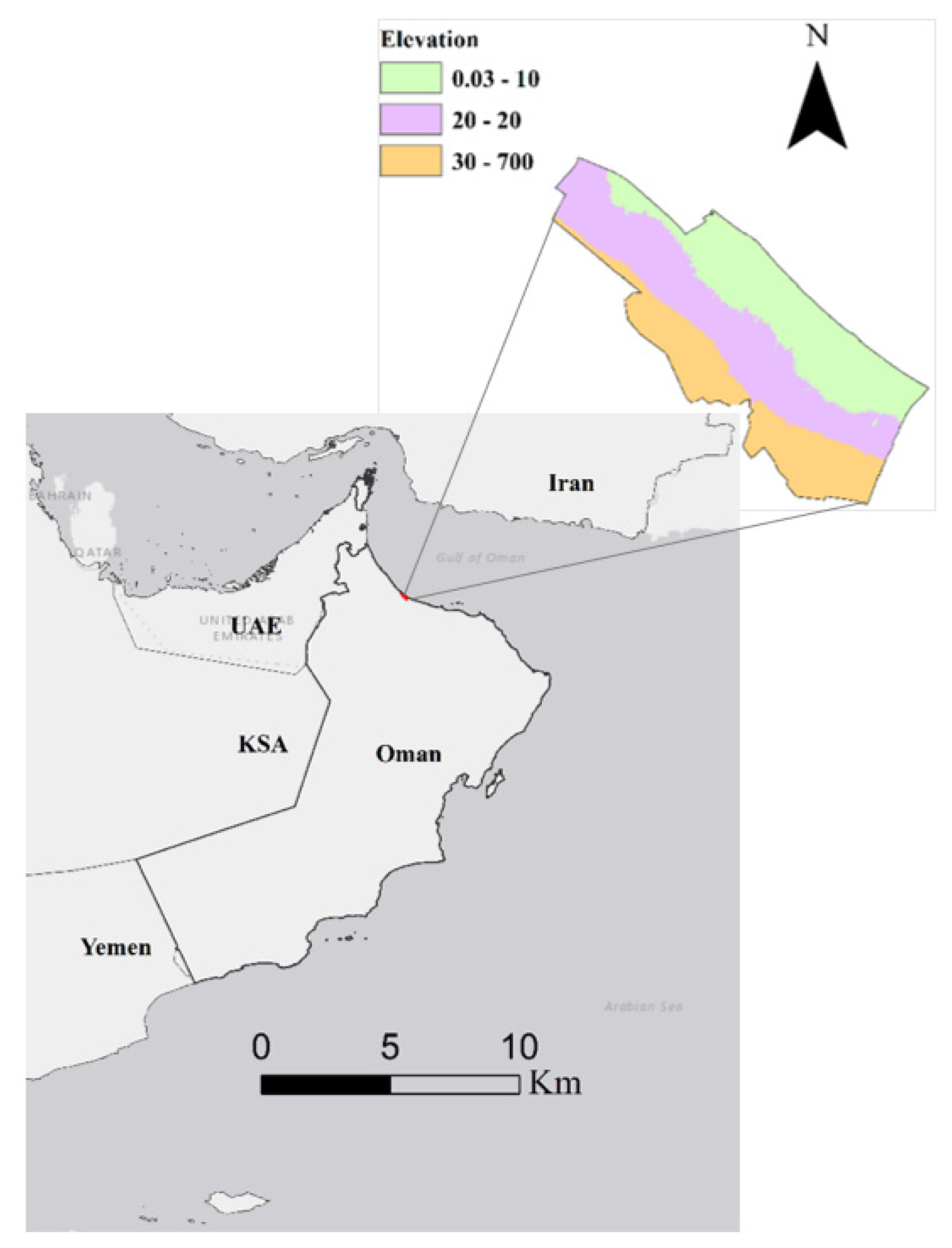
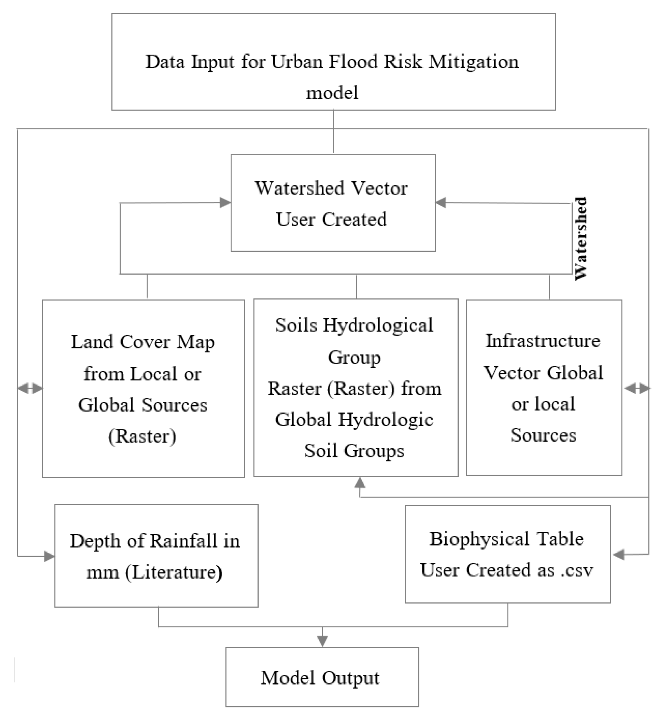
- Watershed, which represented the areas of interest. A vector shapefile developed within ArcGIS 10.8.1 delineating the study site used.
- Numeric value of rainfall depth of a single extreme rainfall event (mm) of a selected storm event. These data obtained from literature [48] and the value of rainfall depth were inserted into the model as a variable.
- Land cover map obtained from the Ministry of Housing and Urban Development (http://www.housing.gov.om (accessed on 15 October 2021)). Land cover map was inserted as a variable at the model. Land use data helped to identify the permeability of each land cover class; as a result, a biophysical table was produced for each class of land cover map in association with the hydrologic soil group (HSG) for each class.
- Soil hydrological group roster was obtained from Global Hydrologic Soil Groups Ross et al. [50] (https://daac.ornl.gov/SOILS/guides/Global_Hydrologic_Soil_Group.html (accessed on 15 October 2021). These data were used to explore the land-texture and its infiltration coefficient following the Soil Taxonomy classification criteria to examine soil conductivity.
- Biophysical table, user-created to include the corresponding value of each land use class in association with HSGs and its association with runoff curve number (CN) (Table 1).
2.3. Data Input
3. Results and Discussions
3.1. Estimated Runoff Distribution
3.1.1. Watershed Resilience to Flash Flood
3.1.2. Al Kahboura Shoreline Erosion
4. Conclusions
Author Contributions
Funding
Informed Consent Statement
Data Availability Statement
Conflicts of Interest
References
- [IPCC] International Panel on Climate Change. Summary for policymakers. In Climate Change 2013: The Physical Science Basis. Contribution of Working Group I to the Fifth Assessment Report of the Intergovernmental Panel on Climate Change; Stocker, T.F., Qin, D., Plattner, G.-K., Tignor, M., Eds.; Cambridge University: Cambridge, UK, 2013; pp. 1–30. [Google Scholar] [CrossRef]
- [IPCC] International Panel on Climate Change. Climate change: Impacts, adaptation, and vulnerability. Part A: Global and sectoral aspects. In Contribution of Working Group II to the Fifth Assessment Report of the Intergovernmental Panel on Climate Change; Field, C.B., Barros, V.R., Dokken, D.J., Eds.; Cambridge University: Cambridge, UK, 2014; p. 1150. [Google Scholar]
- Gissi, E.; Manea, E.; Mazaris, A.D.; Fraschetti, S.; Almpanidou, V.; Bevilacqua, S.; Katsanevakis, S. A review of the combined effects of climate change and other local human stressors on the marine environment. Sci. Total Environ. 2021, 755, 142564. [Google Scholar] [CrossRef] [PubMed]
- Fan, X.; Miao, C.; Duan, Q.; Shen, C.; Wu, Y. Future climate change hotspots under different 21st century warming scenarios. Earths Future 2021, 96, e2021EF002027. [Google Scholar] [CrossRef]
- Allen, M.; Dube, O.P.; Solecki, W.; Aragón-Durand, F.; Cramer, W.; Humphreys, S.; Mulugetta, Y. Global Warming of 1.5 °C. An IPCC Special Report on the Impacts of Global Warming of 1.5 °C above Pre-Industrial Levels and Related Global Greenhouse Gas Emission Pathways, in the Context of Strengthening the Global Response to the Threat of Climate Change, Sustainable Development, and Efforts to Eradicate Poverty. Sustainable Development, and Efforts to Eradicate Poverty. 2018. Available online: https://www.ipcc.ch/site/assets/uploads/sites/2/2019/05/SR15_Citation.pdf (accessed on 10 November 2021).
- Kundu, S.K.; Santhanam, H. A report on the impacts of cyclone Yaas over a fish landing center vulnerable to cyclonic storms and natural hazards–Talsari, Northern Odisha. Local Environ. 2021, 26, 1043–1050. [Google Scholar] [CrossRef]
- Fernando, N.; Amaratunga, D.; Haigh, R.; Wise, B.; Prasanna, J.; Jayasinghe, N. Life two years after relocation: Status quo of natural hazard induced displacement and relocation in Kegalle, Sri Lanka. In Multi-Hazard Early Warning and Disaster Risks; Springer: Berlin/Heidelberg, Germany, 2021; pp. 3–25. [Google Scholar]
- Luo, S.; Cai, F.; Liu, H.; Lei, G.; Qi, H.; Su, X. Adaptive measures adopted for risk reduction of coastal erosion in the People’s Republic of China. Ocean Coast. Manag. 2015, 103, 134–145. [Google Scholar] [CrossRef]
- Špitalar, M.; Gourley, J.J.; Lutoff, C.; Kirstetter, P.E.; Brilly, M.; Carr, N. Analysis of flash flood parameters and human impacts in the US from 2006 to 2012. J. Hydrol. 2014, 519, 863–870. [Google Scholar] [CrossRef]
- Alipour, A.; Ahmadalipour, A.; Moradkhani, H. Assessing flash flood hazard and damages in the southeast United States. J. Flood Risk Manag. 2020, 13, e12605. [Google Scholar] [CrossRef]
- Munich, R.E. NatCatSERVICE. 2020. Available online: https://natcatservice.munichre.com/ (accessed on 12 November 2021).
- Cannon, C.; Gotham, K.F.; Lauve-Moon, K.; Powers, B. The climate change double whammy: Flood damage and the determinants of flood insurance coverage, the case of post-Katrina New Orleans. Clim. Risk Manag. 2020, 27, 100–210. [Google Scholar] [CrossRef]
- Luijendijk, A.; Hagenaars, G.; Ranasinghe, R.; Baart, F.; Donchyts, G.; Aarninkhof, S. The state of the world’s beaches. Sci. Rep. 2018, 8, 6641. [Google Scholar] [CrossRef]
- Coca-Domínguez, O.; Ricaurte-Villota, C. Validation of the hazard and vulnerability analysis of coastal erosion in the Caribbean and pacific coast of Colombia. J. Mar. Sci. Eng. 2019, 7, 260. [Google Scholar] [CrossRef] [Green Version]
- Abel, N.; Gorddard, R.; Harman, B.; Leitch, A.; Langridge, J.; Ryan, A.; Heyenga, S. Sea level rise, coastal development and planned retreat: Analytical framework, governance principles and an Australian case study. Environ. Sci. Policy 2011, 14, 279–288. [Google Scholar] [CrossRef]
- Baig, M.R.I.; Ahmad, I.A.; Shahfahad; Tayyab, M.; Rahman, A. Analysis of shoreline changes in Vishakhapatnam coastal tract of Andhra Pradesh, India: An application of digital shoreline analysis system (DSAS). Ann. GIS 2020, 26, 361–376. [Google Scholar] [CrossRef]
- Mahmud, M.I.; Mia, A.J.; Islam, M.A.; Peas, M.H.; Farazi, A.H.; Akhter, S.H. Assessing bank dynamics of the Lower Meghna River in Bangladesh: An integrated GIS-DSAS approach. Arab. J. Geosci. 2020, 13, 602. [Google Scholar] [CrossRef]
- Martínez, C.; Contreras-López, M.; Winckler, P.; Hidalgo, H.; Godoy, E.; Agredano, R. Coastal erosion in central Chile: A new hazard? Ocean Coast. Manag. 2018, 156, 141–155. [Google Scholar] [CrossRef]
- Masselink, G.; Castelle, B.; Scott, T.; Dodet, G.; Suanez, S.; Jackson, D.; Floc’h, F. Extreme wave activity during 2013/2014 winter and morphological impacts along the Atlantic coast of Europe. Geophys. Res. Lett. 2016, 43, 2135–2143. [Google Scholar] [CrossRef]
- Toimil, A.; Losada, I.J.; Hinkel, J.; Nicholls, R.J. Using quantitative dynamic adaptive policy pathways to manage climate change-induced coastal erosion. Clim. Risk Manag. 2021, 33, 100–342. [Google Scholar] [CrossRef]
- Fernández-Montblanc, T.; Duo, E.; Ciavola, P. Dune reconstruction and revegetation as a potential measure to decrease coastal erosion and flooding under extreme storm conditions. Ocean Coast. Manag. 2020, 188, 105075. [Google Scholar] [CrossRef]
- Mendez-Tejeda, R.; Pérez-Valentín, K.A.; Barreto-Orta, M. Impact of extreme weather events on the beaches of Puerto Rico: The case of ocean park, San Juan. Am. J. Mar. Sci. 2020, 8, 1–5. [Google Scholar] [CrossRef]
- Robin, N.; Billy, J.; Castelle, B.; Hesp, P.; Laporte-Fauret, Q.; Lerma, A.N.; Michalet, R. Beach-dune recovery from the extreme 2013-2014 storms erosion at Truc Vert Beach, Southwest France: New insights from ground-penetrating radar. J. Coast. Res. 2020, 95, 588–592. [Google Scholar] [CrossRef]
- Takeuchi, K.; Chavoshian, A.; Simonovic, S.P. Floods: From risk to opportunity. J. Flood Risk Manag. 2018, 11, e12046. [Google Scholar] [CrossRef] [Green Version]
- Centre for Research on the Epidemiology of Disasters. Natural Disasters 2019: Now Is the Time to Not Give Up. Brussels: CRED. 2020. Available online: https://www.cred.be/publications (accessed on 9 November 2021).
- Al Ruheili, A.; Dahm, R.; Radke, J. Wadi flood impact assessment of the 2002 cyclonic storm in Dhofar, Oman under present and future sea level conditions. J. Arid. Environ. 2019, 165, 73–80. [Google Scholar] [CrossRef]
- IPCC. Summary for policymakers. In Climate Change 2021: The Physical Science Basis. Contribution of Working Group I to the Sixth Assessment Report of the Intergovernmental Panel on Climate Change; Masson-Delmotte, V., Zhai, P., Pirani, A., Connors, S.L., Péan, C., Berger, S., Caud, N., Chen, Y., Goldfarb, L., Gomis, M.I., et al., Eds.; Cambridge University Press: Cambridge, UK, 2021; in press. [Google Scholar]
- IPCC. Climate Change and Land: An IPCC Special Report on Climate Change, Desertification, Land Degradation, Sustainable Land Management, Food Security, and Greenhouse Gas Fluxes in Terrestrial Ecosystems; Shukla, P.R., Skea, J., Buendia, E.C., Masson-Delmotte, V., Pörtner, H.-O., Roberts, D.C., Zhai, P., Slade, R., Connors, S., van Diemen, R., et al., Eds.; 2019; in press; Available online: https://spiral.imperial.ac.uk/bitstream/10044/1/76618/2/SRCCL-Full-Report-Compiled-191128.pdf (accessed on 20 November 2021).
- Salimi, M.; Al-Ghamdi, S.G. Climate change impacts on critical urban infrastructure and urban resiliency strategies for the Middle East. Sustain. Cities Soc. 2020, 54, 101948. [Google Scholar] [CrossRef]
- Al Ruheili, A.; Radke, J. Visualization of 2002 storm surge along the coast of Dhofar, case study of Oman. Environ. Dev. Sustain. 2018, 22, 501–517. [Google Scholar] [CrossRef]
- Al Ruheili, A.M.; Boluwade, A. Quantifying coastal shoreline erosion due to climatic extremes using remote-sensed estimates from Sentinel-2A data. Environ. Processes 2018, 8, 1121–1140. [Google Scholar] [CrossRef]
- Hereher, M.E. Assessment of infrastructure vulnerability to tsunamis upon the coastal zone of Oman using GIS. Geosciences 2020, 10, 175. [Google Scholar] [CrossRef]
- Kwarteng, A.Y.; Al-Hatrushi, S.M.; Illenberger, W.K.; McLachlan, A.; Sana, A.; Al-Buloushi, A.S.; Hamed, K.H. Beach erosion along Al Batinah coast, Sultanate of Oman. Arab. J Geosci. 2016, 9, 85. [Google Scholar] [CrossRef]
- Hereher, M.; Al-Awadhi, T.; Al-Hatrushi, S.; Charabi, Y.; Mansour, S.; Al-Nasiri, N.; El-Kenawy, A. Assessment of the coastal vulnerability to sea level rise: Sultanate of Oman. Environ. Earth Sci. 2020, 79, 369. [Google Scholar] [CrossRef]
- Al-Sariri, T. Coastal Zone and Climate Change Management in Oman. Ph.D. Thesis, University of Surrey, Guildford, UK, 2014. [Google Scholar]
- Richthofen, A.V. A Critical Reconstruction of Modern Urban Settlement Patterns in Muscat and Al Batinah Based on Military Maps. J. Oman Stud. 2018, 19, 85–100. [Google Scholar] [CrossRef]
- Membery, D. Monsoon tropical cyclones: Part 2. Weather 2002, 57, 246–255. [Google Scholar] [CrossRef]
- Civil Aviation Authority (CAA). Directorate General of Meteorology; Preliminary Report on Tropical Cyclone 1–4 October 2021; Department of Research and Development: Muscat, Oman, 2021.
- Tyagi, A.; Bandyopadhyay, B.K.; Mohapatra, M.; Goel, S.; Kumar, N.; Mazumdar, A.B.; Khole, M. A Report on the Super Cyclonic Storm “GONU” during 1–7 June 2007; India Meteorological Department, Government of India: New Delhi, India, 2011; p. 82.
- Al Slami, K.A. Shaheen Cyclone [Oman News]. Sultanate of Oman, TV. 2021. Available online: https://wwitv.com/tv_channels/52.htm (accessed on 4 October 2021).
- Al Nassriya, Z. Solidarity Eases Impacts of Shaheen. 2021. Available online: https://www.omanobserver.om/article/1109858/oman/community/solidarity-eases-impact-of-shaheen (accessed on 21 November 2021).
- National Center for Statistical Information (NCSI). Census 2020. Available online: https://www.ncsi.gov.om/Elibrary/LibraryContentDoc/bar_final%20pop%20new%20copy_74cdfa39-1584-4195-ae46-226bf73742b7.pdf (accessed on 19 November 2021).
- Al-Hatrushi, S.M. Monitoring of the shoreline change using remote sensing and GIS: A case study of Al Hawasnah tidal inlet, Al Batinah coast, Sultanate of Oman. Arab. J. Geosci. 2013, 6, 1479–1484. [Google Scholar] [CrossRef]
- Al-Hatrushi, S.; Ramadan, E.; Charabi, Y. Application of geo-processing model for a quantitative assessment of coastal exposure and sensitivity to sea level rise in the Sultanate of Oman. Am. J. Clim. Chang. 2015, 4, 379. [Google Scholar] [CrossRef] [Green Version]
- Lotfy, A. Using GIS and remote sensing to map coastline changes of Wedam Alsahel area, Batinah, Oman between 1998 and 2008. In Proceedings of the 33rd Asian Conference on Remote Sensing, Pattaya, Thailand, 26–30 November 2012. [Google Scholar]
- Hamel, P.; Guerry, A.D.; Polasky, S.; Han, B.; Douglass, J.A.; Hamann, M.; Daily, G.C. Mapping the benefits of nature in cities with the InVEST software. Npj Urban Sustain. 2021, 1, 25. [Google Scholar] [CrossRef]
- Kadaverugu, A.; Rao, C.N.; Viswanadh, G.K. Quantification of flood mitigation services by urban green spaces using InVEST model: A case study of Hyderabad city, India. Model Earth Syst. Environ. 2021, 7, 589–602. [Google Scholar] [CrossRef]
- Al-Lmalkiyah, S.H. Development of Regional Intensity-Duration-Frequency (idf) Curves for Sultanate of Oman. Ph.D. Thesis, Sultan Qaboos University, Muscat, Oman, 2018. [Google Scholar]
- Choudri, B.S.; Baawain, M.; Ahmed, M. Review of water quality and pollution in the coastal areas of Oman. J. Poll Res. 2015, 34, 429–439. [Google Scholar]
- Ross, C.W.; Prihodko, L.; Anchang, J.Y.; Kumar, S.S.; Ji, W.; Hanan, N.P. Global Hydrologic Soil Groups (HYSOGs250m) for Curve Number-Based Runoff Modeling; ORNL DAAC: Oak Ridge, TN, USA, 2018. [Google Scholar] [CrossRef]
- Rosenzweig, B.; Ruddell, B.L.; McPhillips, L.; Hobbins, R.; McPhearson, T.; Cheng, Z.; Kim, Y. Developing knowledge systems for urban resilience to cloudburst rain events. Environ. Sci. Policy 2019, 99, 150–159. [Google Scholar] [CrossRef]
- Lian, H.; Yen, H.; Huang, J.C.; Feng, Q.; Qin, L.; Bashir, M.A.; Liu, H. CN-China: Revised runoff curve number by using rainfall-runoff events data in China. Water Res. 2020, 177, 115767. [Google Scholar] [CrossRef] [PubMed]
- Darabi, H.; Haghighi, A.T.; Mohamadi, M.A.; Rashidpour, M.; Ziegler, A.D.; Hekmatzadeh, A.A.; Kløve, B. Urban flood risk mapping using data-driven geospatial techniques for a flood-prone case area in Iran. Hydro. Res. 2020, 51, 127–142. [Google Scholar] [CrossRef] [Green Version]
- Xu, D.; Ouyang, Z.; Wu, T.; Han, B. Dynamic trends of urban flooding mitigation services in Shenzhen, China. Sustainability 2020, 12, 4799. [Google Scholar] [CrossRef]
- Scionti, F.; Miguez, M.G.; Barbaro, G.; De Sousa, M.M.; Foti, G.; Canale, C. Integrated methodology for Urban Flood Risk Mitigation in cittanova, Italy. J. Water Resour. Plan. Manag. 2018, 144, 1–10. [Google Scholar] [CrossRef]
- Thieler, E.R.; Himmelstoss, E.A.; Zichichi, J.L.; Ergul, A. Digital Shoreline Analysis System (DSAS) Version 4.0—An ArcGIS Extension for Calculating Shoreline Change (ver. 4.4, July 2017); Open-File Report; U.S. Geological Survey: Reston, VA, USA, 2009. Available online: https://pubs.er.usgs.gov/publication/ofr20081278 (accessed on 11 October 2021).
- Himmelstoss, E.A.; Henderson, R.E.; Kratzmann, M.G.; Farris, A.S. Digital Shoreline Analysis System (DSAS) Version 5.0 User Guide; Open-File Report; U.S. Geological Survey: Reston, VA, USA, 2018; pp. 79–110.
- Pelorosso, R. Modeling and urban planning: A systematic review of performance-based approaches. Sustain. Cities Soc. 2020, 52, 2210–6707. [Google Scholar] [CrossRef]
- Li, L.; Uyttenhove, P.; Van Eetvelde, V. Planning green infrastructure to mitigate urban surface water flooding risk–A methodology to identify priority areas applied in the city of Ghent. Landsc. Urban Plan. 2020, 194, 103703. [Google Scholar] [CrossRef]
- Lourenco, I.B.; de Oliveira AK, B.; Marques, L.S.; Barbosa AA, Q.; Verol, A.P.; Magalhaes, P.C.; Miguez, M.G. A framework to support flood prevention and mitigation in the landscape and urban planning process regarding water dynamics. J. Clean. Prod. 2020, 277, 122983. [Google Scholar] [CrossRef]
- dos Santos, E.A.; Medeiros, M.B.; Ferreira, E.J.; Simon, M.F.; Oliveira, W.L.; Costa, F.R. Palm distribution patterns in the southwestern Brazilian Amazon: Impact of a large hydroelectric dam. For. Ecol. Manag. 2020, 463, 1–10. [Google Scholar] [CrossRef]
- Evadzi, P.I.; Zorita, E.; Hünicke, B. Quantifying and predicting the contribution of sea-level rise to shoreline change in Ghana: Information for coastal adaptation strategies. J. Coast. Res. 2017, 33, 1283–1291. [Google Scholar] [CrossRef]
- Das, S.K.; Sajan, B.; Ojha, C.; Soren, S. Shoreline change behavior study of Jambudwip island of Indian Sundarban using DSAS model. Egypt. J. Remote Sens. Space Sci. 2021, 24, 961–970. [Google Scholar] [CrossRef]
- Miller, A.; Blair, D.G.; Dubyna, J. Shoreline Erosion and Sea Level Rise. 2020. Available online: https://oceanwatch.ca/howesound/wp-content/uploads/sites/2/2020/08/OceanWatch-HoweSoundReport2020-CC-ShorelineErosion.pdf (accessed on 1 November 2021).
- Cantasano, N.; Caloiero, T.; Pellicone, G.; Aristodemo, F.; De Marco, A.; Tagarelli, G. Can ICZM Contribute to the Mitigation of Erosion and of Human Activities Threatening the Natural and Cultural Heritage of the Coastal Landscape of Calabria? Sustainability 2021, 13, 1122. [Google Scholar] [CrossRef]
- Landry, C.E.; Shonkwiler, J.S.; Whitehead, J.C. Economic values of coastal erosion management: Joint estimation of use and existence values with recreation demand and contingent valuation data. J. Environ. Econ. Manag. 2020, 103, 1–17. [Google Scholar] [CrossRef]



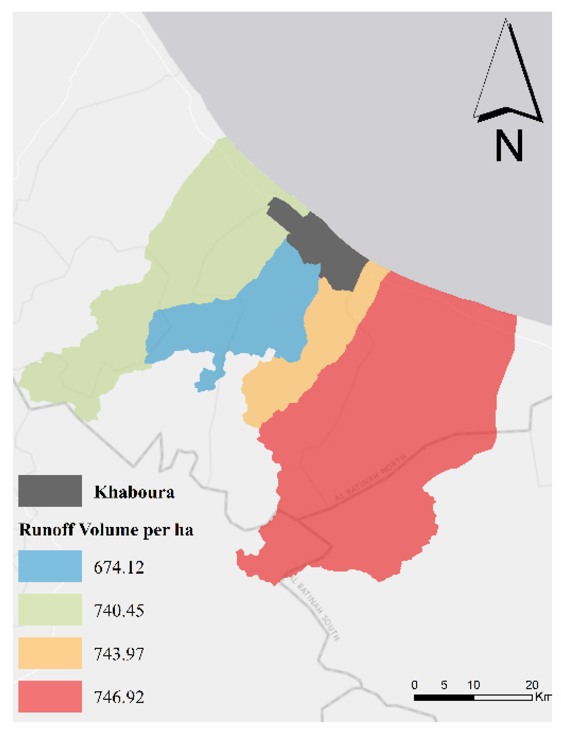
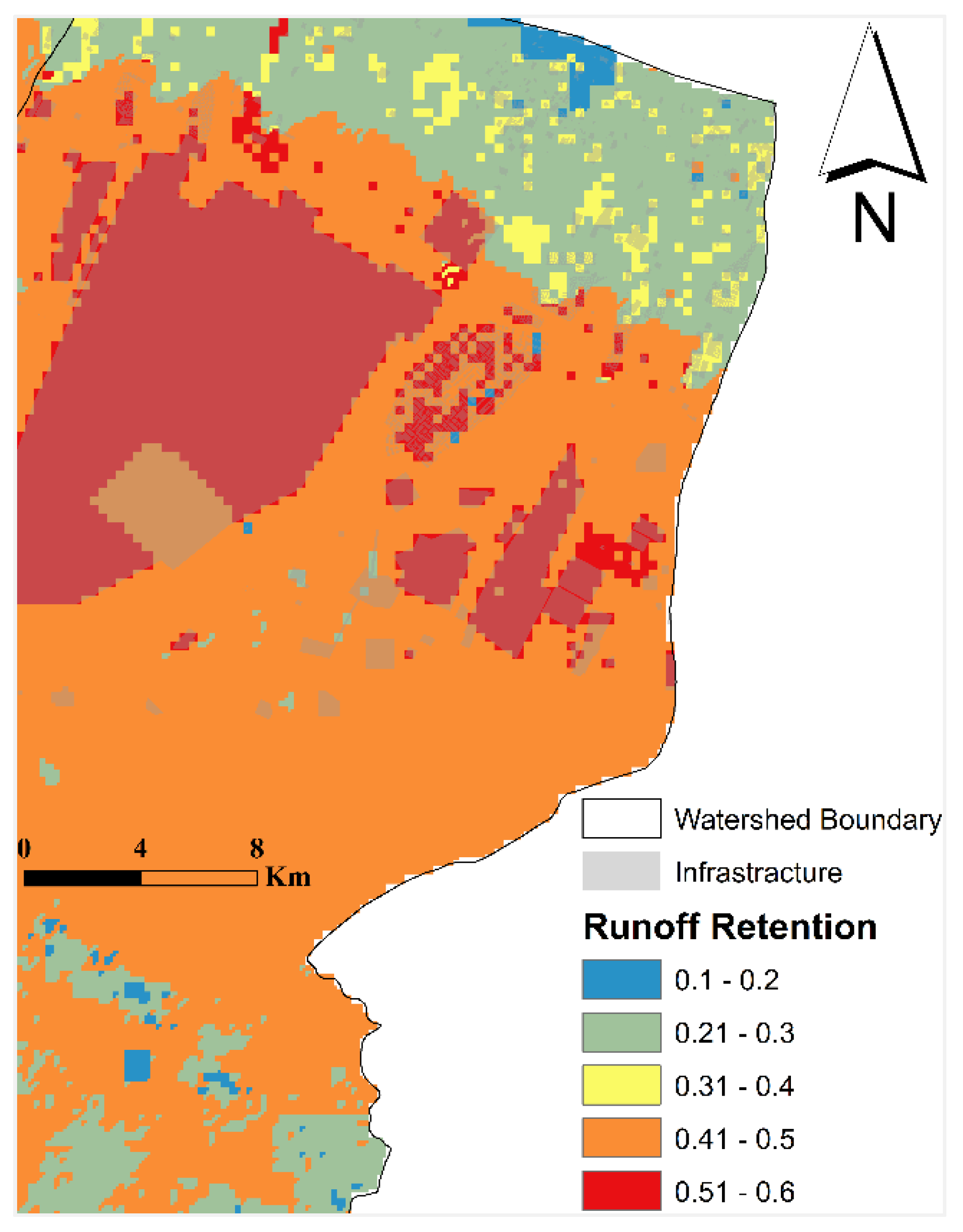


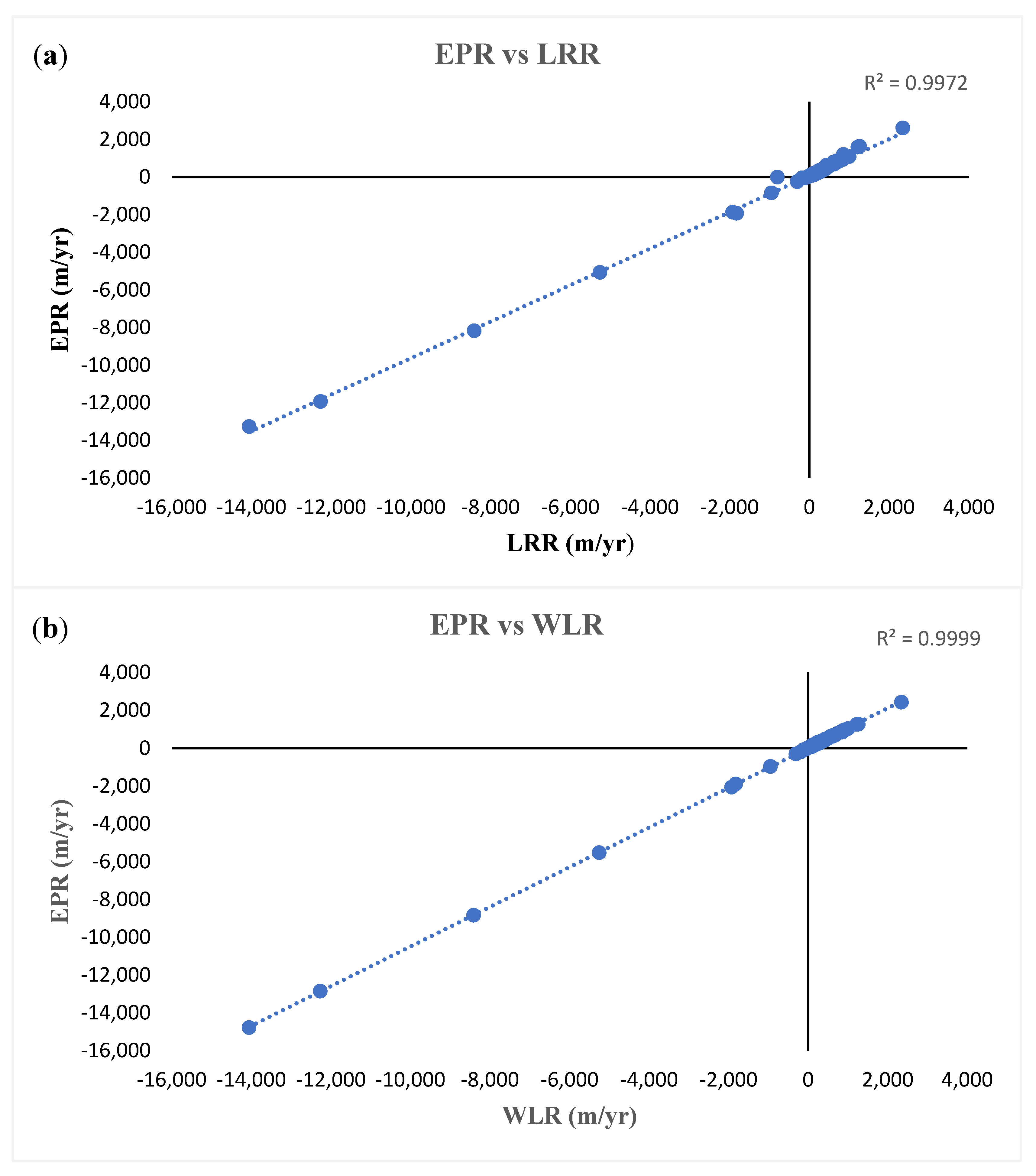
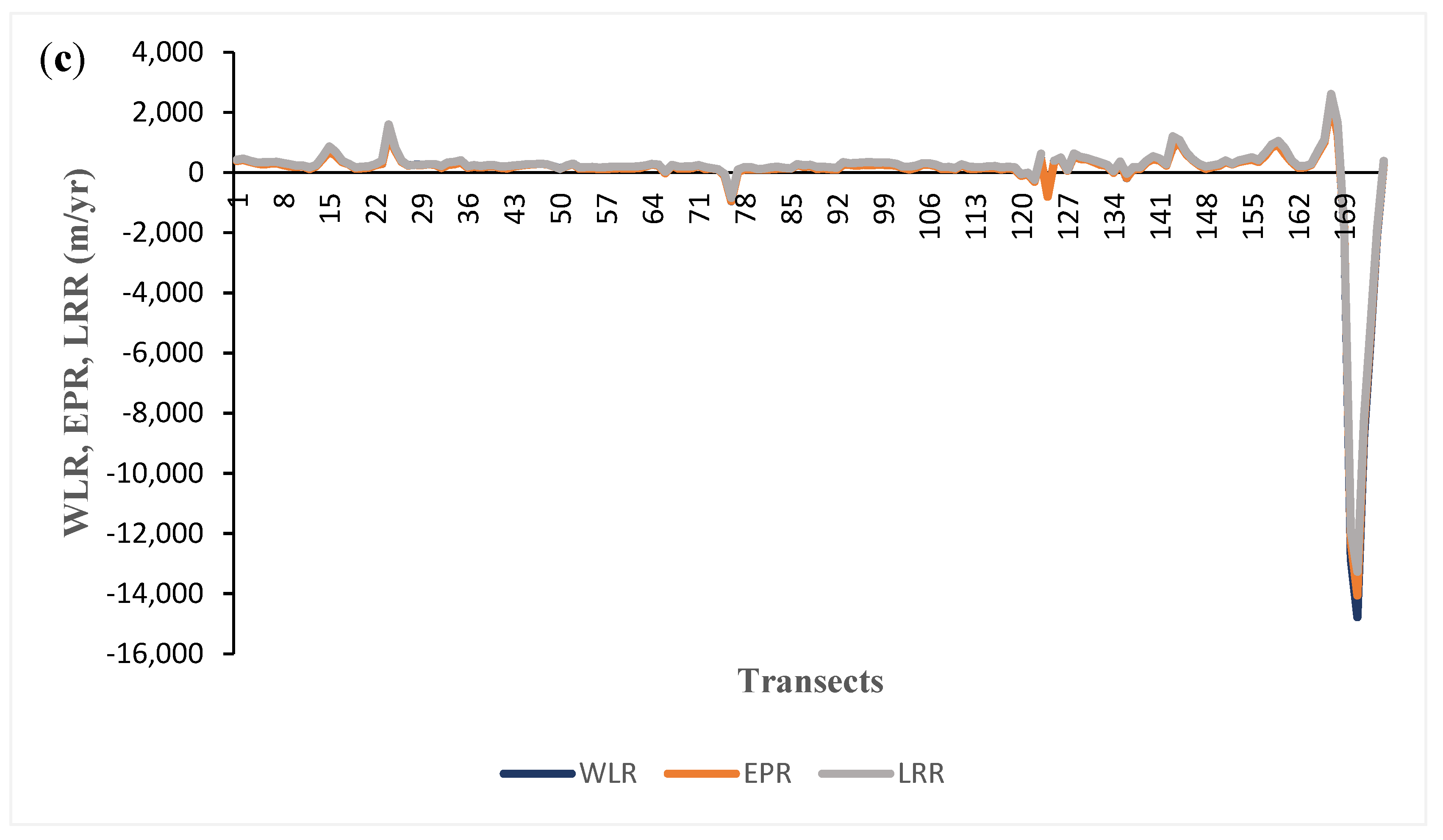
| Watershed | Area (ha) | Rain Event (mm) | Runoff Retention Index (%) | Runoff Index (%) | Runoff Retention Volume (m3) | Runoff Retention Volume (m3)/Area (ha) | Runoff Volume (m3)/ Area (ha) |
|---|---|---|---|---|---|---|---|
| Wadi Shafan | 75,524 | 121.1 | 38 | 62 | 348,499.02 | 461.44 | 740.45 |
| 213.8 | 25 | 75 | 398,569.26 | 527.74 | 1594.2 | ||
| Wadi Al Hawasinah | 38,994 | 121.1 | 44 | 56 | 206,516.72 | 529.61 | 674.12 |
| 213.8 | 29 | 71 | 240,535.31 | 616.85 | 1508.3 | ||
| Al Mayha-Mabrah-Al Hajir System | 145,030 | 121.1 | 38 | 62 | 664,486.28 | 458.17 | 746.92 |
| 213.8 | 25 | 75 | 760,771.79 | 524.56 | 1603.0 | ||
| Wadi Mashin | 27,459 | 121.1 | 38 | 62 | 126,420.82 | 460.39 | 743.97 |
| 213.8 | 25 | 75 | 144,078.97 | 524.70 | 1601.6 |
| Platform | Date | Tile Number |
|---|---|---|
| SENTINEL-2A | 27 September 2021 | T40QEM |
| 7 October 2021 | ||
| SENTINEL-2B | 2 October 2021 | |
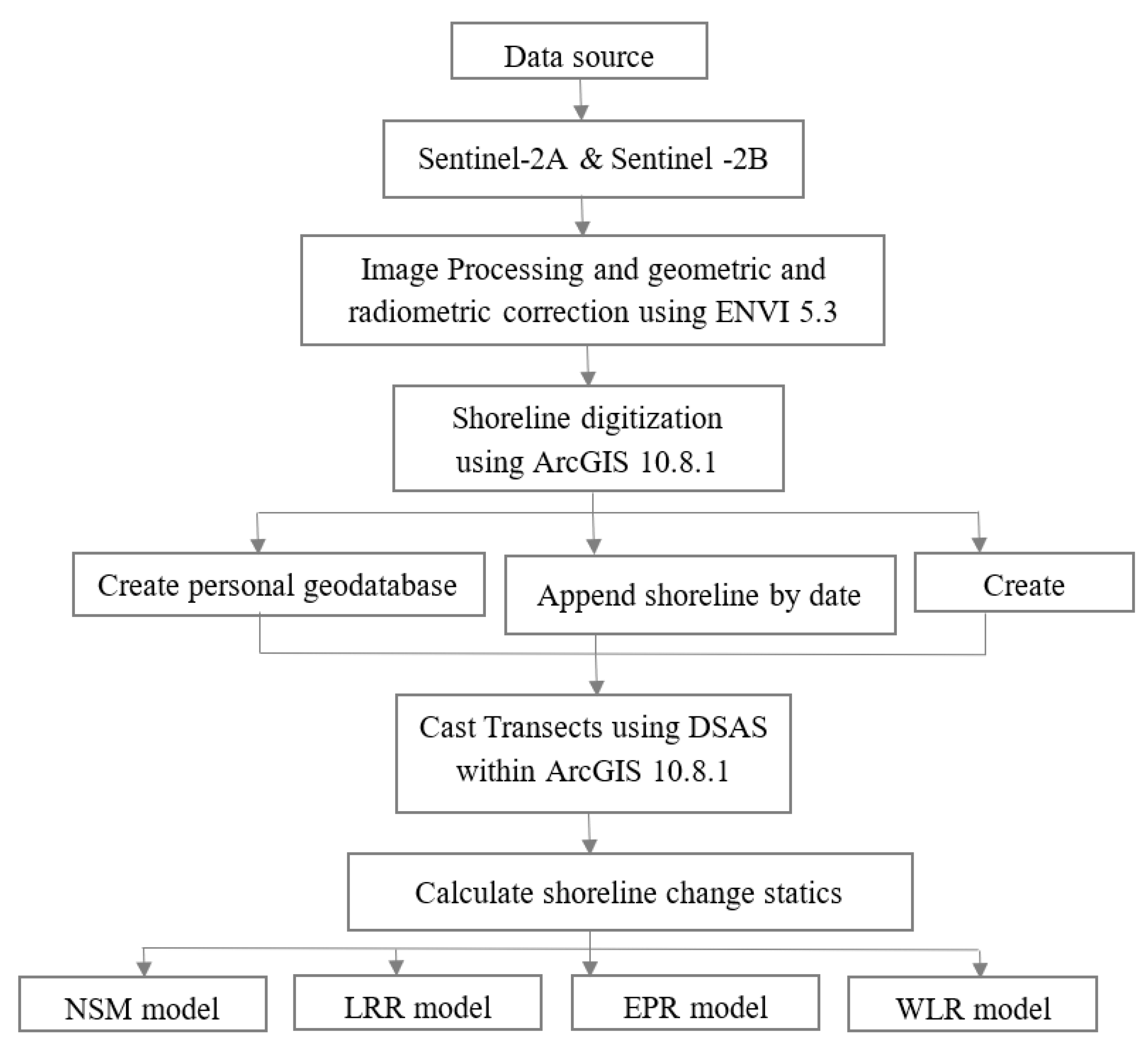
| 1 November 2021 |
Publisher’s Note: MDPI stays neutral with regard to jurisdictional claims in published maps and institutional affiliations. |
© 2022 by the author. Licensee MDPI, Basel, Switzerland. This article is an open access article distributed under the terms and conditions of the Creative Commons Attribution (CC BY) license (https://creativecommons.org/licenses/by/4.0/).
Share and Cite
AlRuheili, A.M. A Tale of Shaheen’s Cyclone Consequences in Al Khaboura City, Oman. Water 2022, 14, 340. https://doi.org/10.3390/w14030340
AlRuheili AM. A Tale of Shaheen’s Cyclone Consequences in Al Khaboura City, Oman. Water. 2022; 14(3):340. https://doi.org/10.3390/w14030340
Chicago/Turabian StyleAlRuheili, Amna M. 2022. "A Tale of Shaheen’s Cyclone Consequences in Al Khaboura City, Oman" Water 14, no. 3: 340. https://doi.org/10.3390/w14030340
APA StyleAlRuheili, A. M. (2022). A Tale of Shaheen’s Cyclone Consequences in Al Khaboura City, Oman. Water, 14(3), 340. https://doi.org/10.3390/w14030340


