1. Introduction
Geothermal resources are buried underground, and are controlled by conditions such as geological structure, stratum lithology, and water–rock interaction [
1,
2,
3,
4,
5]. Their distribution is closely related to plate tectonics, and plate tectonic movement has a controlling effect on global geotropic activities. Among the geothermal resources, the groundwater that absorbs geothermal heat in the porous or fractured rock layer and has a temperature of 25 °C or higher is called thermal mineral water, which is a hydrothermal geothermal resource. Understanding the geochemical evolution process and geochemical characteristics of geothermal fluids is of great significance to the sustainable development of geothermal resources [
6,
7]. China’s medium- and low-temperature geothermal resources are widely distributed in the continental crustal uplift and crustal subsidence areas within the plate. The fault zones formed in different geological periods are widely distributed in the crustal uplift. Among the crustal uplift areas, the geotropic areas along the southeast coast are the most densely distributed areas of hot springs. Hainan Island is very rich in thermal mineral water resources, and 32 rift-type belt distributions of thermal mineral water have been identified to date, distributed in the central part of Hainan Island and strictly controlled by the relevant faults.
Thermal mineral water is widely used for power generation, heating, aquaculture, textile printing and dyeing, etc. [
8,
9,
10,
11,
12,
13]. Meanwhile, geothermal water has higher medical and healthcare value when the content of some trace elements in hot spring water reaches the water quality standard of medical mineral water [
14,
15,
16,
17,
18,
19]. Although Hainan Province is rich in thermal mineral water resources, their level of development and utilization is not high, due to the constraints of many factors. Therefore, under the premise of rational planning of resource development, finding effective methods of searching for minerals will be of great help to improve the utilization rate of thermal mineral water [
20].
Studies have shown that the trace element content of soils around thermal mineral water tends to increase or decrease to varying degrees [
21]. Among them, elements that are more than 10 times more abundant than the crustal Clarke numbers include Hg, As, Sb, Bi, W, Mn, etc.; elements that are several times more abundant include Pb, Zn, Ni, Li, Rb, Be, B, etc.; and elements that are slightly less abundant include Cu, Mo, Sn, etc. Therefore, the search for thermal mineral water based on soil element geochemistry can be an effective technical method. The use of multipurpose regional geochemical surveys to obtain elemental index data is a very effective method [
22]. This work aimed to search and forecast the island-wide thermal mineral water distribution based on the discovered thermal mineral water and the deep-soil geochemical data of a multipurpose regional geochemical survey.
2. Overview of the Study Area
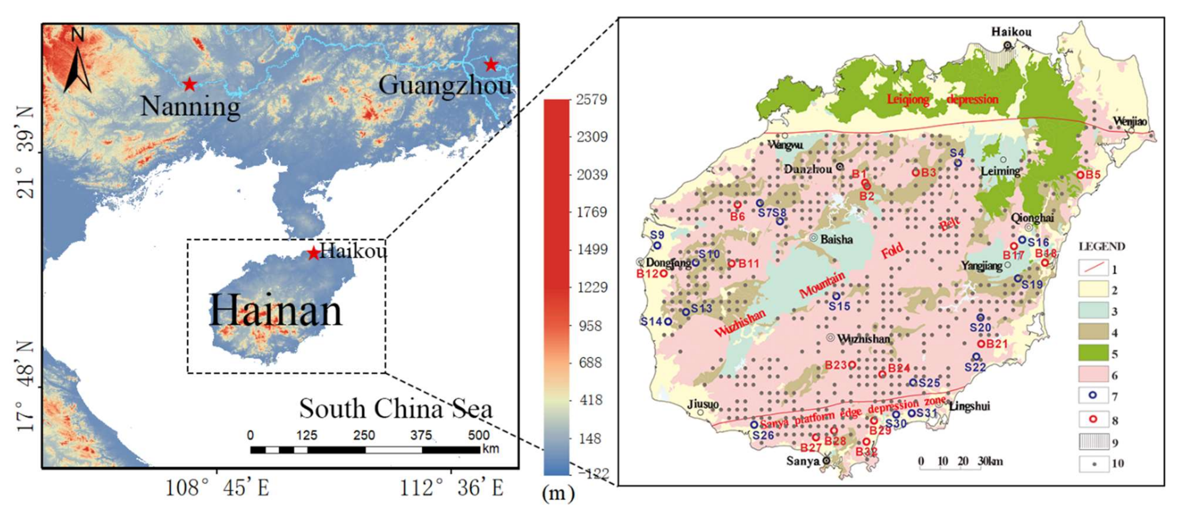
Hainan Island is located in the northwest of the South China Sea, with a diverse and tropical ecosystem (
Figure 1); it is a dome-shaped island composed of mountains, hills, and terraces—high in the middle, and low on all sides. The central part is mountainous, with the Wuzhishan Mountain as the main peak, while the geological structure in the north is similar to that of the Leizhou Peninsula, which is a low-platform land. Hainan Island belongs to the southern extension of the second uplift zone of the Neocathaysian system. The regional tectonics are relatively developed, with four main groups: east–west, north–east, north–west, and north–south. Fault zones are more widely distributed on Hainan Island, and this geological structure provides favorable conditions for heat rising along the fault zones at depth, and for water infiltrating, flowing, pooling, and storing along the fault zones. Due to the development of faults, different rock layers are in contact with one another, causing the thermal mineral water to come into contact with different strata and absorb various chemical elements. The east–west rupture is the seismic control structure of Hainan Island. At the same time, the north–east fault zone was formed before the Cretaceous period, and exerts very obvious control over the seismic, geothermal, hydrogeological, and mineral resources. The combination and interaction of these tectonic zones is an important factor affecting the formation and outcrop of emergence of thermal mineral water on Hainan Island [
23].
Hainan Island is located over two geotectonic units; with the east–west Jiusuo–Lingshui fault zone in the south of Hainan Island being the boundary, the Sanya area to the south of the fault zone belongs to the Sanya platform edge depression zone of the South China Sea platform, while the north of the fault zone belongs to the South China Fold System. As the main part of Hainan Island, the South China Fold System is divided into the Wuzhishan Mountain Fold Belt to the south of the Wangwu–Wenjiao fault, and the Leiqiong depression to the north.
Sedimentary rocks exposed on the surface of Hainan Island originate from all eras, except for the Devonian and Jurassic periods, starting from the oldest Mesoproterozoic strata to the Cenozoic erathem. Among them, the Mesoproterozoic to Paleozoic strata have undergone different degrees of metamorphism and are distributed in an island-like manner in the middle of Hainan Island within intermediate-acid intrusive rocks; the Mesozoic strata consist mainly of Cretaceous red beds distributed in areas such as Baisha, Leiming, and Yangjiang; the Cenozoic strata consist mainly of Quaternary rocks distributed around the island and along the Wangwu–Wenjiao fault. Intrusive rocks cover the most extensive area of the island, distributed mainly in the central area of Hainan Island, and consisting mostly of intermediate-acid rocks and acidic rocks, more than 60% of the lithology of which is monzogranite. Volcanic rocks are mainly distributed in the northern part of Hainan Island, and are Cenozoic Neogene–Quaternary mafic volcanic rocks.
The 32 rift-type belt distributions of thermal mineral water found on Hainan Island are mainly located in the central part of the island, in the area of intermediate-acid intrusive rocks and sedimentary–metamorphic rocks, with small amounts exposed in the Quaternary and Cretaceous red bed areas. In the northern part of Hainan Island, there are porous layers of thermal mineral water, 29 of which have been exploited—mainly in the central area of Haikou.
3. Material and Methods
3.1. Sampling and Analysis
Selection of soil samples: All sampling data were obtained from the multipurpose regional geochemical survey project of Hainan Island conducted in 2004–2011. The method of collecting samples was geochemical measurement with two-layer grid sampling. Surface samples at depths of 0–20 cm were taken, with a density of 1 sample per 4 km
2. The deep soil samples (150–200 cm) were generally collected at the center of each 16 km
2 grid. Deep soils are more profoundly influenced by subsurface thermal mineral water than surface soils, and at the same time are less affected by the secondary effects of the surface environment. Therefore, deep soil samples from the multipurpose regional geochemical survey of Hainan Island were selected as carriers for indicating subsurface thermal mineral water. The total number of samples was 2197, and the analytical test items included 54 elemental indicators, such as Hg content, pH, and SiO
2 content. Results for some of these elements of solid samples are shown in
Table 1. The analysis methods were the same as those of Li Min et al. [
24].
3.2. Methods
Selection of known thermal mineral water outcrops and their evaluation indicators: The thermal mineral water temperature results obtained by the two collection methods are shown in
Table 2. A total of 9 of the 32 identified fissure-type zones of thermal mineral water were found in the Quaternary (7) or Cretaceous strata (2), while the others were found in intermediate-acid intrusive rocks (17) or sedimentary–metamorphic rocks (6). Considering that sources of soil materials in the Quaternary and Cretaceous strata have a longer material migration distance, only the remaining 23 thermal mineral water sites were included in the analytical study. The thermal mineral water sites B2 and B1 are shown in
Figure 1; among them, site B2 thermal mineral water was not used because it was too close to site B1, meaning that we could not distinguish it from site B1 in terms of precision of soil sampling (one sample per 16 km
2). The measured temperatures of thermal mineral water at 22 locations were used as the calibration indices for thermal mineral water, and their corresponding elemental contents were calculated based on the average of four surrounding deep soil samples (with distance as the calculation weight). However, these four samples needed to have the same geological background as the location of the thermal mineral water; otherwise, only 1–3 samples of the same geological background were taken for calculation.
Linear regression analysis was performed with the thermal mineral water temperature as the dependent variable, and with the 54 elemental indicators of the deep soil corresponding to the thermal mineral water at 22 locations as the independent variables; the regression method used was stepwise regression. The predicted temperatures of all deep soil samples were calculated based on the regression model developed.
The prospective sites for thermal mineral water prospecting were delineated based on the prediction intervals of the dependent variables and the content intervals of the independent variables of the 22 regression samples, as well as the geological backgrounds they represented and the regional fault of the location.
Data processing and mapping were conducted with the MAPGIS 6.5 (Zondy Cyber, China, Wuhan) or SPSS 11.0 software.
4. Results and Discussion
4.1. Regression Analysis Results
Table 3 shows the regression analysis coefficients for the 22 regression analysis samples.
The basic idea of stepwise regression analysis is that the selected variable can be eliminated when it becomes unimportant after the introduction of new variables, and the eliminated variable can be reselected into the equation when it becomes important after the introduction of new variables. This can avoid multicollinearity and obtain a relatively simple model with fewer variables, in which only a few variables with significant effects are usually retained, thus having a better simulation prediction effect [
25].
In the fourth step of the stepwise regression analysis (model 4), only 4 of the 54 elemental indicators—namely, Th, Be, Ce, and Sn—entered the regression equation. From the standardized coefficients (without the effects of elemental content magnitude), the elements Th and Be affected the temperature of thermal mineral water most significantly, but Be had a negative effect. Since Be is mainly enriched in pegmatite and during pneumatolysis of the late stage of intermediate-acid magma intrusion [
26,
27], in terms of time, the temperature of this phase is obviously lower than that of the early intrusion phase, while in terms of space, it occurs mostly at structurally open tectonic sites, where the temperature will be further decreased. Therefore, the entry of Be into the regression equation indicates the locations of convergent outcrops of thermal mineral water, i.e., tectonic sites with high Be levels and cooling. As mentioned above, the thermal mineral water sites in the rift belt on Hainan Island are strictly controlled by the respective fracture tectonics. In addition, the acidic intrusive rocks in which Th, Ce, and Sn occur are the heat sources for the thermal mineral water. Thus, the combination of the elements is a common manifestation of the thermal source and the propagation sites of the thermal mineral waters, with great geological significance.
The significance levels of the coefficients of the independent variables in model 4 were all less than 0.05, indicating that the four independent variables were significantly indicative of the thermal mineral water temperature; the corresponding index tolerance was relatively large, and the variance inflation factor was relatively small (< 10), thus allowing the rejection of the hypothesis of covariance between them.
The regression Equation (1) was obtained from the unstandardized coefficients as follows:
where W is the original unstandardized content value of each element.
In fact, a reasonable linear regression analysis requires an existing linear correlation between the dependent and independent variables. The correlation analysis showed that the correlation coefficients between the thermal mineral water temperature and the elemental content of Th, Be, Ce, and Sn at 22 locations were 0.5014, −0.2101, 0.4764, and 0.4024, respectively, which were the largest or smallest relative to the other elements. In addition, the correlation coefficient between the predicted and measured temperatures from the regression analysis was 0.8240 at a 0.01 significance level, making it highly significant. Therefore, the linear regression model was considered reasonable, and could be used for thermal mineral water temperature prediction calculations based on corresponding deep soil samples.
4.2. Calculation of Predicted Values of Thermal Mineral Water Temperature and Sample Selection of Deep Soils
Based on the above regression equation, the predicted thermal mineral water temperature was calculated for all deep soil samples. Overall, 2197 samples had a predicted maximum value of 403.95 °C and a minimum value of −106.54 °C, with a mean value of 59.20 and a standard deviation of 39.97 °C. Naturally, this was a purely mathematical calculation, and trade-offs were necessarily made while considering many factors, such as geological background.
The geological backgrounds of the 22 regression samples were all intermediate-acid intrusive rocks or sedimentary–metamorphic rocks; hence, the same geological backgrounds were required for deep soils, meaning that only 1257 samples were suitable. The content intervals of the four independent variables of the regression samples were 12.05–29.55 for Th, 1.17–3.77 for Be, 47.00–122.85 for Ce, and 1.90–7.89 for Sn (all units in mg/kg), which were also used as the qualifying conditions for deep soil sample selection, and only 555 samples remained out of 1257 samples. The range of regression prediction values of regression analysis samples (25.20–87.83 mg/kg) was also used as one of the qualifying factors, so that only 547 out of 555 samples remained. Under the three mutually inclusive conditions, the 547 samples were the most equivalent predicted samples to the regression analysis samples; this was the fundamental basis for delineating the prospective thermal mineral water areas, and its spatial distribution is shown in
Figure 1.
4.3. Thermal Mineral Water Prospecting Distant Site Trapping
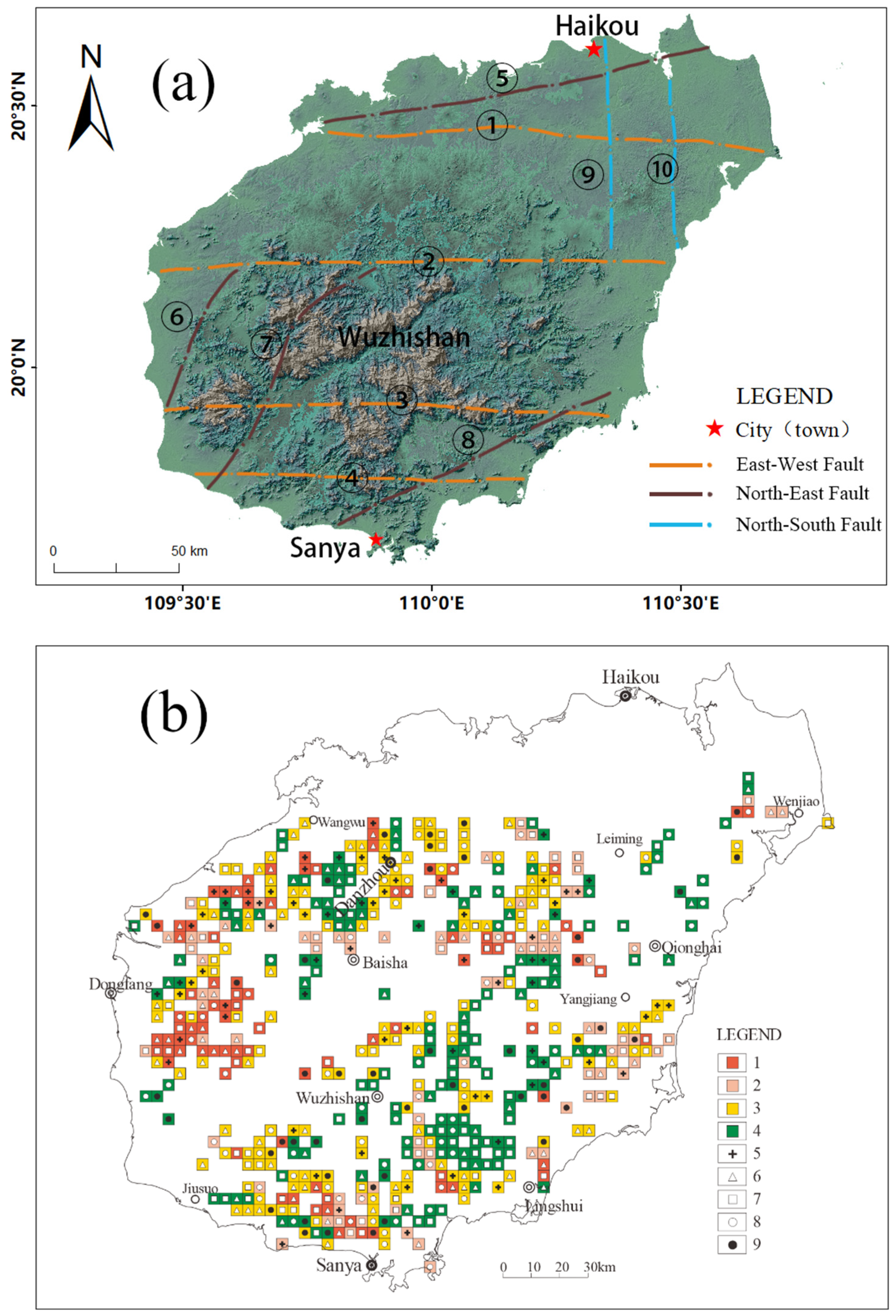
As mentioned earlier, the rift-type belt distribution of thermal mineral water in Hainan Island is strictly controlled by the relevant faults, and almost all of them are east–west and north–east directional. Therefore, in addition to the above-mentioned deep soil prediction sample points as the fundamental basis for delineating prospective areas of thermal mineral water, faults are also one of the essential bases.
The regional faults within the control area of the predicted sample point were the necessary elements for classifying the prospective sites (areas). The main fault zones on Hainan Island are listed in
Figure 2a. The sample sites with east–west or north–east directional fracture structures passing through them, intersected by other directional faults, were considered to be A1-level prospecting sites; those with only east–west or north–east directional faults passing through them were considered to be A2-level prospecting sites; those with only other directional faults passing through them were considered to be A3-level prospecting sites; and those without faults passing through them were considered to be B-level prospecting sites.
The prospective thermal mineral water sites in the rift-type belt distribution on Hainan Island are shown in
Figure 2b. Of the 547 prospective sites, 91 were at A1-level, 90 were A2, 185 were A3, and 181 were B. The distribution of prospective sites by temperature interval is shown in
Table 4; among them, 14 of the A1-level prospecting sites had predicted temperatures of 25–40 °C, 27 of 40–50 °C, 25 of 50–60 °C, 16 of 60–70 °C, and 10 of >70 °C; 11 of the A2-level prospecting sites had predicted temperatures of 25–40 °C, 29 of 40–50 °C, 30 of 50–60 °C, 30 of 60–70 °C, 16 of 60—70 °C, and four of >70 °C; 29 of the A3-level prospective sites had predicted temperatures of 25–40 °C, 63 of 40–50 °C, 43 of 50–60 °C, 33 of 60–70 °C, and 17 of >70 °C.
5. Conclusions
A linear regression analysis was performed based on the temperature of known thermal mineral water (the dependent variable) and the content of deep soil elemental indicators from a multipurpose regional geochemical survey of Hainan Island (the independent variable); among the 54 basic indicators, 4 indicators—Th, Be, Ce, and Sn—entered the regression equation. The regression model has significant geological significance for thermal mineral water temperature prediction.
Under the constraints of requirements such as the geological background represented by the regression analysis samples, the independent variable content interval, the prediction interval of dependent variables, and the regional faults, 547 prospective thermal mineral water sites were delineated, of which 16.6% were at A1-level. The proportion of A1-level sites that were >70 °C constituted 11% of all A1-level prospective sites, which was greater than the proportion of the A2-level (4%) and A3-level (9%) sites, reflecting the superiority of east–west and north–east directional regional faults in controlling the distribution of thermal mineral water.
The information cited in this study is of low precision, limited completeness, and limited accuracy. Each sample represents an area of 16 km2, so higher precision chemical prospecting and other work are required in order to search for thermal mineral water within the predicted prospective areas. The temperature acquisition methods used in drilled wells and natural outcrops are different, with the latter being less accurate. The thickness of the overlying strata from the elevation of the thermal mineral water outcrop to the surface at the wellhead—as one of the evaluation indicators of thermal mineral water exploration—was also an important indicator for this study; however, this indicator was also not considered, because drilling evaluation work has not been carried out at some of the thermal mineral water outcrops, and the thickness of the cover is unknown. The focus of further research should be to enhance the exploration and evaluation of known thermal mineral water outcrops, and to accurately measure the evaluation indicators in order to provide a scientific basis for understanding of the unknown factors.
Author Contributions
Y.H.: conceptualization, methodology, investigation, writing—review and editing; G.Z.: methodology, investigation, writing—original draft preparation; C.L.: writing—review and editing, supervision; M.R.: investigation, methodology, formal analysis; Y.W.: conceptualization, writing—review and editing; C.M.: writing—review and editing. All authors have read and agreed to the published version of the manuscript.
Funding
This research was funded by the National Land and Resources Geological Survey Project—Ecological Geochemical Survey of Hainan Island (200414200010), the Open Research Fund of Hainan Key Laboratory of Marine Geological Resources and Environment (HNHYDZZYHJKF006, HNHYDZZYHJKF013), and the Hainan Provincial Natural Science Foundation of China (421MS0813).
Institutional Review Board Statement
Not applicable.
Informed Consent Statement
Not applicable.
Data Availability Statement
Not applicable.
Acknowledgments
We appreciate the engineers of the Hainan geological survey for their help in the fieldwork. We are thankful to Jian Wen and Ling Wen for their help and fruitful discussion. We are also grateful to the professors of the China University of Geosciences for their constructive comments, including Zhengdong Ma, Fanglin Li, Zhengyu Bao, Suyun Xie, and Lian Zhou.
Conflicts of Interest
The authors declare no conflict of interest.
References
- Smedley, P.L.; Kinniburgh, D.G. A review of the source, behaviour and distribution of arsenic in natural waters. Appl. Geochem. 2002, 17, 517–568. [Google Scholar] [CrossRef] [Green Version]
- Brown, K.L.; Simmons, S.F. Precious metals in high-temperature geothermal systems in New Zealand. Geothermics 2003, 32, 619–625. [Google Scholar] [CrossRef]
- Zhang, G.; Liu, C.Q.; Hong, L.; Jin, Z.; Han, G.; Ling, L. Geochemistry of the Rehai and Ruidian geothermal waters, Yunnan Province, China. Geothermics 2008, 37, 73–83. [Google Scholar] [CrossRef]
- Gao, F.L.; Yang, X.Q.; Wu, G.A.; Fu, Y.R.; Chen, Y.W. Characteristics of Thermal Springs and Genesis of Thermal Underground Waters in Hainan Island. J. Jilin Univ. 2009, 39, 281–287. [Google Scholar]
- Guo, Q.; Wang, Y. Geochemistry of hot springs in the Tengchong hydrothermal areas, Southwestern China. J. Volcanol. Geotherm. Res. 2012, 215–216, 61–73. [Google Scholar] [CrossRef]
- Qin, D.; Turner, J.V.; Pang, Z. Hydrogeochemistry and groundwater circulation in the Xi’an geothermal field, China. Geothermics 2005, 34, 471–494. [Google Scholar] [CrossRef]
- Guo, Q. Hydrogeochemistry of high-temperature geothermal systems in China: A review. Appl. Geochem. 2012, 27, 1887–1898. [Google Scholar] [CrossRef]
- Ellis, A.J. Quantitative interpretation of chemical characteristics of hydrothermal systems. Geothermics 1970, 2 Pt 1, 516–528. [Google Scholar] [CrossRef]
- Kearey, P.; Wei, H.B. Geothermal fields of China. J. Volcanol. Geotherm. Res 1993, 56, 415–428. [Google Scholar] [CrossRef]
- Aiuppa, A.; Carapezza, M.L.; Parello, F. Fluid geochemistry of the San Vicente geothermal field (El Salvador). Geothermics 1997, 26, 83–97. [Google Scholar] [CrossRef]
- Kosic, K.; Pivac, T.; Romelic, J.; Lazic, L.; Stojanovic, V. Characteristics of thermal–mineral waters in Backa region (Vojvodina) and their exploitation in spa tourism. Renew. Sustain. Energy Rev. 2011, 15, 801–807. [Google Scholar] [CrossRef]
- Joksimovic, M.; Pavlovic, M.A. Conditions and possibilities of direct utilisation of thermal-mineral waters in Raska region, Serbia. Renew. Sustain. Energy Rev. 2014, 32, 107–113. [Google Scholar] [CrossRef]
- Oyuntsetseg, D.; Ganchimeg, D.; Minjigmaa, A.; Ueda, A.; Kusakabe, M. Isotopic and chemical studies of hot and cold springs in western part of Khangai Mountain region, Mongolia, for geothermal exploration. Geothermics 2015, 53, 488–497. [Google Scholar] [CrossRef]
- Szucs, L.; Ratko, I.; Lesko, T.; Szoor, I.; Genti, G.; Balint, G. Double-blind trial on the effectiveness of the Puspokladany thermal water on arthrosis of the knee-joints. J. R. Soc. Health 1989, 109, 7. [Google Scholar] [CrossRef] [PubMed]
- Elkayam, O.; Wigler, I.; Tishler, M.; Rosenblum, I.; Yaron, M. Effect of spa therapy in Tiberias on patients with rheumatoid arthritis and osteoarthritis. J. Rheumatol. 1991, 18, 1799–1803. [Google Scholar]
- Wigler, I.; Elkayam, O.; Paran, D.; Yaron, M. Spa therapy for gonarthrosis: A prospective study. Rheumatol. Int. 1995, 15, 65–68. [Google Scholar] [CrossRef]
- Guillemin, F.; Virion, J.M.; Escudier, P.; Talancé, N.; Weryha, G. Effect on osteoarthritis of spa therapy at Bourbonne-les-Bains. Jt. Bone Spine Rev. Rhum. 2001, 68, 499–503. [Google Scholar] [CrossRef]
- Yilmaz, B.; Goktepe, A.S.; Alaca, R.; Mohur, H.; Kayar, A.H. Comparison of a generic and a disease specific quality of life scale to assess a comprehensive spa therapy program for knee osteoarthritis. Jt. Bone Spine 2004, 71, 563–566. [Google Scholar] [CrossRef]
- Bálint, G.; Buchanan, W.W.; Ádám, A.; Ratkó, I.; Poór, L.; Bálint, P.; Somos, É.; Tefner, I.; Bender, T. The effect of the thermal mineral water of Nagybaracska on patients with knee joint osteoarthritis—A double blind study. Clin. Rheumatol. 2007, 26, 890–894. [Google Scholar] [CrossRef]
- Chrysikopoulos, C.V. Artificial tracers for geothermal reservoir studies. Environ. Geol. 1993, 22, 60–70. [Google Scholar] [CrossRef]
- Farsang, A.; Toth, T.M.; Balog, K. Environmental risks of waste thermal water disposal: Long-therm effects of thermal water seepage on different soil types. Environ. Eng. Manag. J. 2015, 14, 1217–1229. [Google Scholar] [CrossRef]
- Xia, X.; Yang, Z.; Li, G.; Yu, T.; Hou, Q.; Mutelo, A.M. Practicability of monitoring soil Cd, Hg, and Pb pollution based on a geochemical survey in China. Chemosphere 2017, 172, 217–224. [Google Scholar] [CrossRef]
- Shi, X.; Kohn, B.; Spencer, S.; Guo, X.; Li, Y.; Yang, X.; Shi, H.; Gleadow, A. Cenozoic denudation history of southern Hainan Island, South China Sea: Constraints from low temperature thermochronology. Tectonophysics 2011, 504, 100–115. [Google Scholar] [CrossRef]
- Li, M.; Xi, X.; Xiao, G.; Cheng, H.; Yang, Z.; Zhou, G.; Ye, J.; Li, Z. National multi-purpose regional geochemical survey in China. J. Geochem. Explor. 2014, 139, 21–30. [Google Scholar] [CrossRef]
- Shibing, Y.; Yan, Y. Stepwise regression analysis and its application. Stat. Decis. 2017, 7, 31–35. [Google Scholar]
- Michael, O.; Matt, Z.; Carol, C.; Brian, C.; Jeffrey, C. Multi-Element Analysis and Geochemical Spatial Trends of Groundwater in Rural Northern New York. Water 2010, 2, 217. [Google Scholar]
- Taylor, T.P.; Ding, M.; Ehler, D.S.; Foreman, T.M.; Kaszuba, J.P.; Sauer, N.N. Beryllium in the environment: A review. J. Environ. Sci. Health Part A 2003, 38, 439–469. [Google Scholar] [CrossRef]
| Publisher’s Note: MDPI stays neutral with regard to jurisdictional claims in published maps and institutional affiliations. |
© 2022 by the authors. Licensee MDPI, Basel, Switzerland. This article is an open access article distributed under the terms and conditions of the Creative Commons Attribution (CC BY) license (https://creativecommons.org/licenses/by/4.0/).


