1. Introduction
Fatal landslides have affected millions of people and have claimed the lives of thousands around the globe [
1]. Growing landslide frequency in a changing climate is expected with the increasing rainfall magnitudes and anthropogenic activities, which will destabilize sloped regions globally [
2,
3,
4,
5,
6,
7]. In order to conduct a quantitative analysis of the effect of changes in climate on landslide susceptibility, the projection of rainfall scenarios is essential for physically based models and susceptibility assessments [
3,
8,
9]. It is foreseen that the initiation of shallow landslides will have a critical impact on changes in extreme rainfall and antecedent rainfall conditions [
10,
11,
12,
13,
14,
15,
16,
17,
18].
Quantifying the evolution of rainfall variables as an input to physically based landslide models is a critical task. Studies have proposed frameworks and developed methods to assess slope stability under changing climate conditions. Initial assessment studies assess rainfall thresholds for slope susceptibility and incorporate dynamically downscaled climate models to estimate rainfall and typhoon events using extreme rainfall distributions [
19,
20]. The direct use of climate models as an input in impact models is hindered by uncertainties in the model processes that limit the representation of precipitation at a local scale [
21,
22]. The combined effect of these uncertainties leads to a bias between simulations and observations. This requires the post-processing of climate model outputs through a bias correction to be used for quantitative impact assessments [
23].
The incorporation of bias correction methods to establish rainfall thresholds from climate model projections have been used to assess the triggering maximum 1-day rainfall and the antecedent rainfall conditions at durations varying between hours and months prior to a landslide [
20,
23,
24]. One pertinent assumption in establishing thresholds from historical landslide inventories is that the temporal certainty of the recorded events is adequate to reconstruct the triggering rainfall conditions.
The limitation of landslide inventories is highlighted by the observed complex interactions of physical processes that govern the behavior of landslide susceptibility and add uncertainty in the predictions of thresholds [
3,
8,
9]. Therefore, some studies have incorporated extreme rainfall projections from climate change models with physically based landslide susceptibility models to assess the impact on slope stability [
25,
26,
27].
The role of antecedent rainfall as a determining factor for landslide initiation is recognized to significantly influence the rainfall thresholds of slope stability and results in physically based susceptibility models [
8,
10,
11,
12,
13,
14,
15,
16,
17,
18]. This reflects the primary role antecedent rainfall has on soil hydrological conditions that predispose shallow slope stability [
10,
17,
18,
28].
The consideration of antecedent conditions is widely used and a variety of approaches to incorporate its influence are utilized [
29]. Indices have been established to capture the interaction between the rainfall with the predisposing hydromechanical conditions before an extreme rainfall event, and are widely used to establish better-informed thresholds in predicting slope stability [
10,
12,
15,
30]. The use of such indices requires detailed field data and models to capture the hydrological process that governs the movement between rainfall and recharge [
13,
14,
30]. The incorporation of changing climate conditions with such indices requires the downscaling and correction of climate model outputs to serve as hydrological model inputs [
27,
31,
32].
The duration by which antecedent conditions are considered to have a significant influence on stability can be determined as being 30 days. It has been shown that the 30-day antecedent conditions have a significant influence on the rainfall thresholds of slope failure [
16,
33], the recharge in a calibrated antecedent rainfall index [
12,
13,
15], and the physically based seepage and stability model [
17].
A gap in the existing frameworks and methods was observed in the incorporation of antecedent rainfall scenarios in susceptibility assessments from bias-corrected climate model projections. The projections of antecedent conditions on landslides provide significant information on the subsurface system and are critical to assessing susceptibility under climate change conditions. [
3,
10,
11,
12,
13,
14].
Incorporating changes in rainfall and associated parameters under changing climate conditions requires predictions of future susceptibility using physically based models [
3]. This will give us better insight on the interaction between changes in rainfall and the physical processes governing slope stability [
8,
25]. It is essential to incorporate climate factor approaches and ensemble methods to reduce the uncertainty of rainfall projections [
32,
34,
35]. The objective of this research is to establish a methodological framework to quantify landslide-triggering rainfall in the future with climate model projections and to measure the uncertainty in these projections. This framework integrates methods to establish present extreme and seasonal rainfall scenarios and to derive projections with bias-corrected climate change model outputs. Methods to quantify the performance of the derived present rainfall scenarios and the uncertainty in the ensemble of bias-corrected rainfall projections are presented in support of this framework. An application of this to a case study area over Wanzhou County, China, is presented to quantify the change in present rainfall conditions under the Representative Concentration Pathway 8.5 (RCP8.5) climate projections. The results and the identification of sources of uncertainties in this study aim to demonstrate a viable method to link climate model projections and quantitative slope susceptibility assessments.
2. Study Area
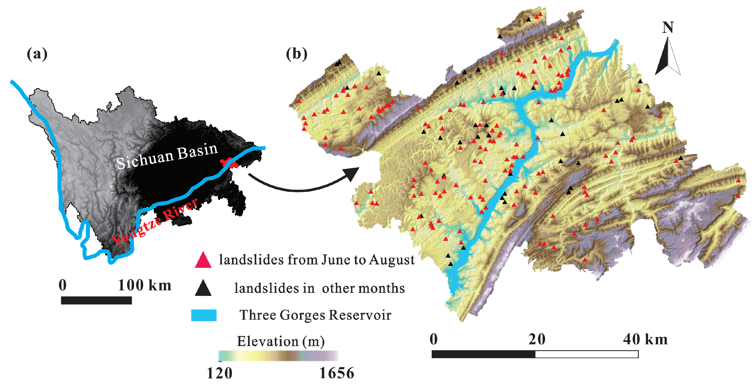
Wanzhou County, China, is located with the coordinates 30°24′25″ N, 107°52′22″ E to 31°14′58″ N, 108°53′25″ E. The 3457 km
study area, in
Figure 1, is located within the Three Gorges Reservoir, along the Yangtze River upstream of the Three Gorges Dam. The elevation in Wanzhou County ranges from 120 m to 1656 m asl, and, overall, the elevation of the northwest part is lower than the southeast part [
36,
37].
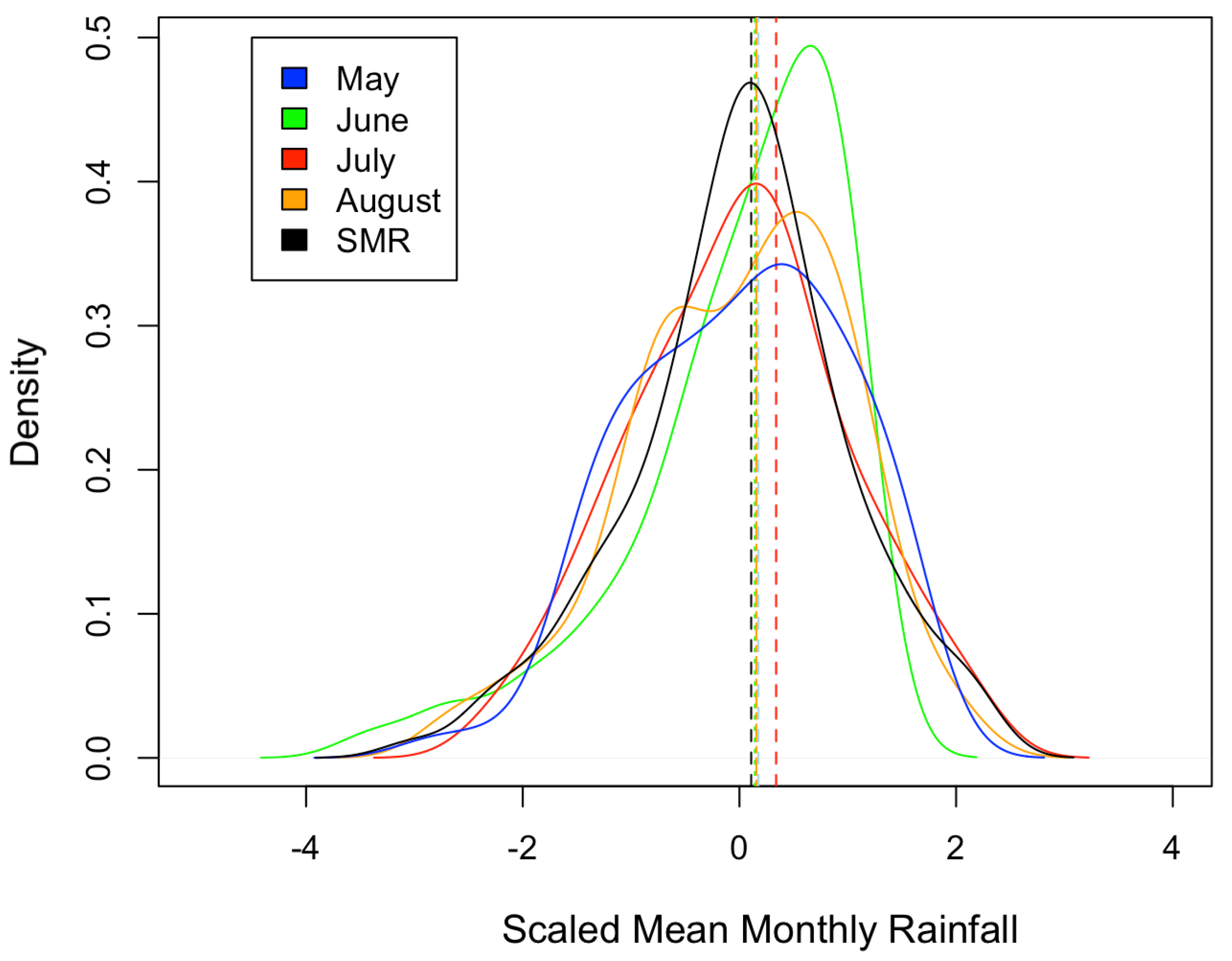
This region of China is categorized as a subtropical humid monsoon zone with a mean annual precipitation of 1191.3 mm. The precipitation in the area is characterized by 90% of the annual rainfall occurring between May and September. Summer rainfall can be characterized by short intense rainstorms with daily rainfall values exceeding 100 mm/day [
38]. The lithology in Wanzhou County mainly comprises a Jurassic (J) system and a Triassic (T) system. The Jurassic system consists of mudstone, sandstone, siltstone, and shale. The Triassic system is primarily composed of limestone, claystone, sandstone, siltstone, and coal [
36].
Frequent disastrous and complex landslide events in Wanzhou County have been the subject of research and susceptibility assessments in recent years due to its proximity to the Three Gorges Dam along the Yangtze River [
39,
40,
41,
42,
43]. Heavy rainfall has been attributed as a significant trigger to the frequent landslides that have occurred [
36,
44,
45].
A shallow landslide inventory created by the Wanzhou Institute of Geological Environment Monitoring, in
Figure 1b, captures the spatial distribution of events within the Wanzhou County area from 1995–2005. Within this period, 186 shallow landslide events occurred across the study area. It was found that 146 of the shallow landslides in the area occurred between June and August.
The area of the shallow landslides varies from 50 m
to 10
m
, with a total area of approximately 0.4 km
. All of the landslides have a depth of less than 10 m, and volumes between 200 m
to 10
m
[
37]. Typical summer rainfall events that trigger shallow landslides are intense heavy rainfall over a short duration and continuous rainfall lasting for days [
37,
45]. As a consequence, the shallow landslides cause considerable damages and losses every summer in Wanzhou County [
38].
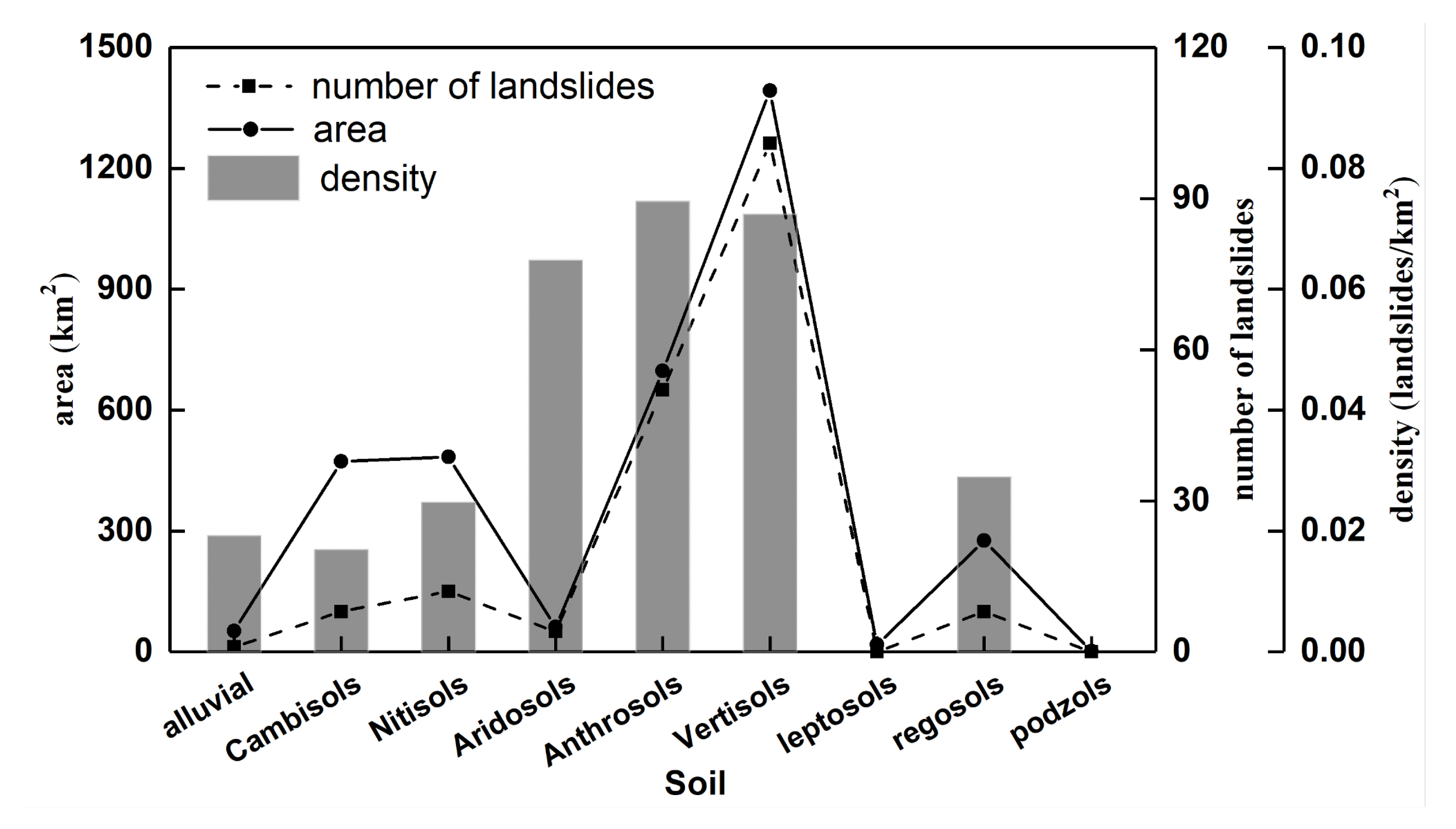
Vertisols, Anthrosols, and Cambisols are the most common soil types in Wanzhou County, accounting for more than 75% of the total area in
Figure 2. More than 80% of shallow landslides occurred in Vertisols and Anthrosols, whereas other soil types are of minor importance for landslide occurrence. The peak density of shallow landslides is also related to these two soil types.
Extensive assessments of climate change projection of rainfall and extreme events in the Upper Yangtze River Basin and across China have been conducted. An increase in the annual precipitation, frequency of wet days, and extreme rainfall by the end of the 21st century is projected in the region [
48,
49,
50]. Other studies suggest a decrease in the precipitation rate and extremes by the middle of the 21st century [
31,
51].
Therefore, this study aimed to apply the framework to quantify the change between present and future rainfall scenarios for the summer season.
5. Discussion
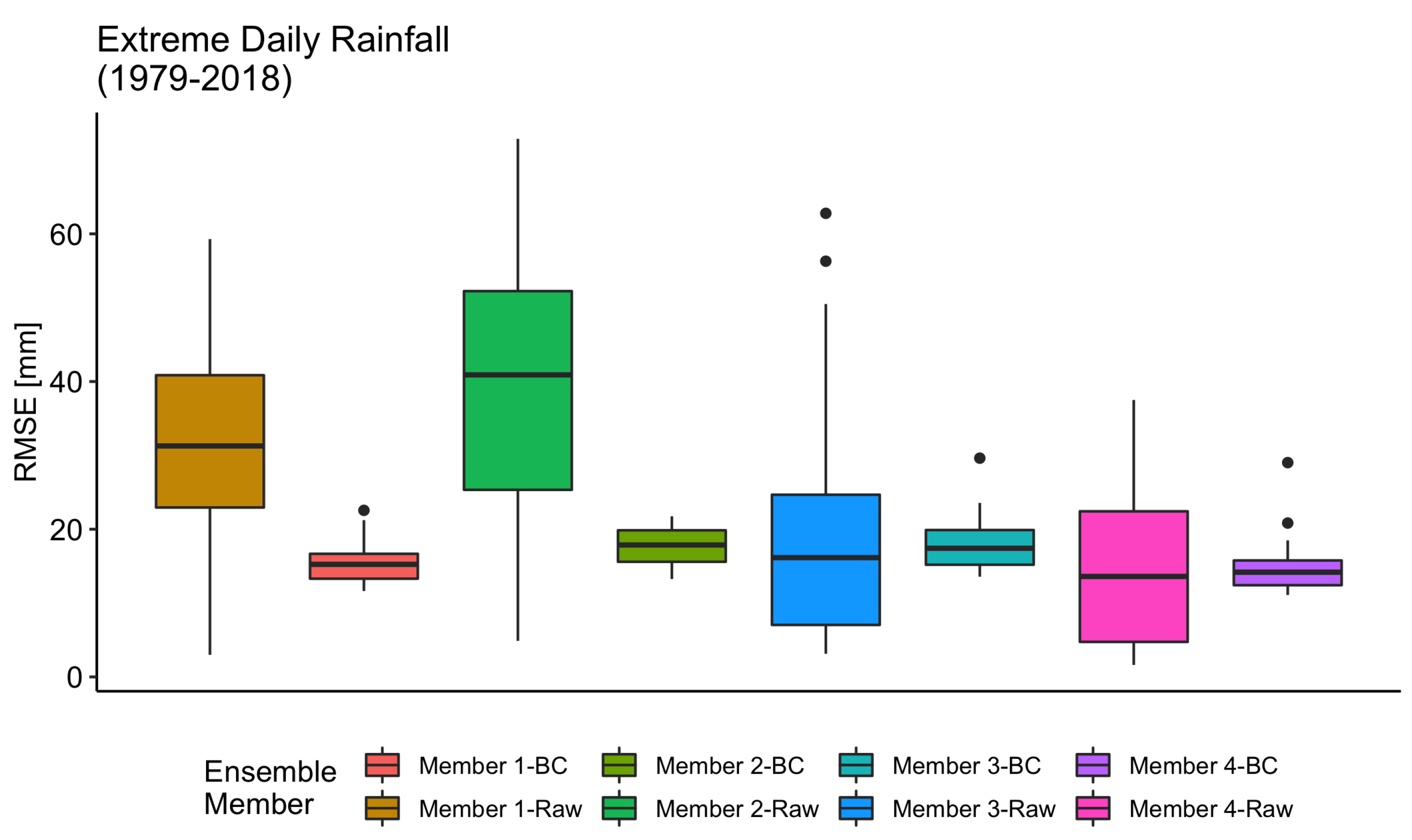
This section discusses items regarding the application of the framework to the Wanzhou County area. First, the limitations of the CMFD data in representing the present rainfall conditions. Second, a comparison of the resulting ensemble projections with other studies looking at trends over Wanzhou County. Finally, an analysis of sources of uncertainty derived from the bias correction methodology and ensemble model selection.
The present rainfall scenarios derived to represent the summer season are subject to the limitation of the CMFD data product in capturing actual ground conditions. The rainfall during this season is driven by the Asian summer monsoon, where extreme rainfall events are triggered by tropical cyclones. Unfavorable spatial and temporal resolutions have been a hindrance in capturing the rainfall intensities associated with this driving phenomenon [
49]. The CMFD data product underestimated extreme rainfall and accumulated rainfall when measured to station-derived indices in the Qinghai-Tibet Plateau [
79]. An assessment of gridded precipitation products found that the component rainfall products of the CMFD dataset were relatively consistent over the East Asian region [
80]. The underestimation by the CMFD product compared to station rainfall measurements is attributed to the influence of the integration and interpolation of various rainfall products [
52].
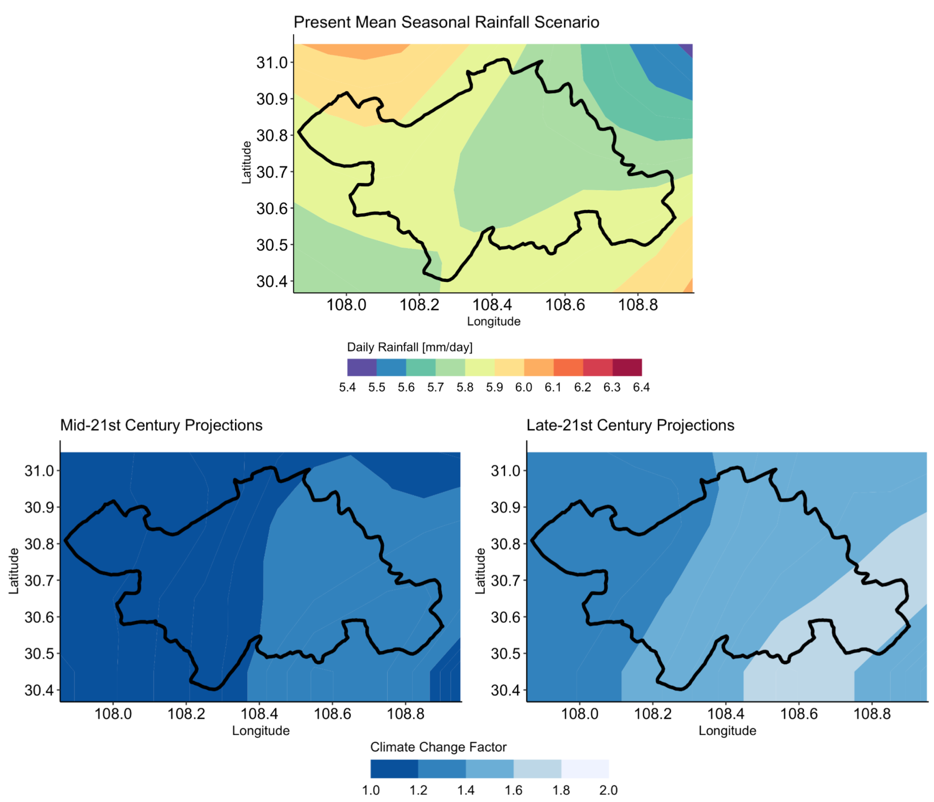
The ensemble projections of MSR and EDR scenarios resulted in independent trends for the mid-21st century and late-21st century. The RCP 8.5 pathway projections revealed significant variation among the four RCM ensemble members listed in
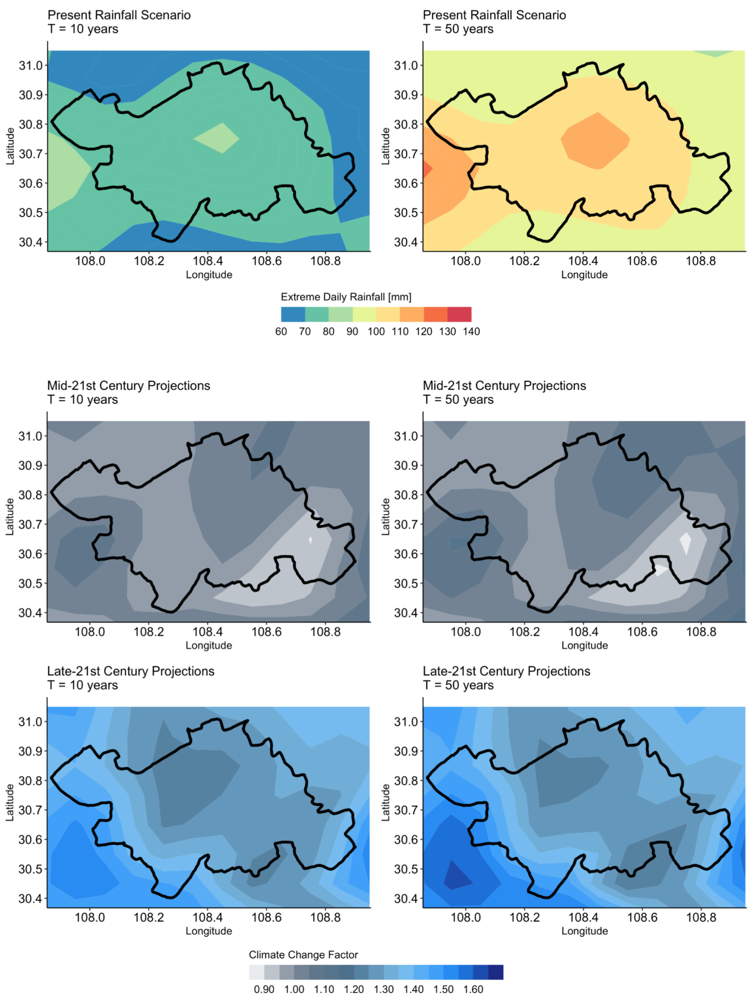
Table 1. The mid-21st century MSR was predicted to increase by 20–40% relative to the reference scenario in this study. These projections follow a projected trend of increase in annual precipitation under the RCP 8.5 pathway [
48]. The significant increase in MSR magnitude over the summer months can be attributed to an anticipated increase in wet days over the East Asian region [
49]. This increase in total precipitation will lead to wet antecedent conditions and higher water tables, which will result in a more frequent attainment of critical water contents that will destabilize slopes [
81]. An anticipated increase in shallow landslide activity in Southeast Asia, Central and South America, Southern Italy, and across the African continent is expected in response to climate change [
3].
This study projected a decrease in EDR magnitude in the near future that follows projections of decreasing precipitation rates by 19.05–19.25 mm per decade by studies using a RegCM4 model at 25 km of horizontal resolution under the RCP8.5 scenario [
31,
58]. An analysis of six RegCM4 projections found that the decrease in extremes indices was not statistically significant, and was due to an underestimation of specific humidity and water vapor fluxes by the RCMs [
51]. A significant increasing trend in maximum daily precipitation by the mid-21st century was projected to be 10.90% over the Yangtze River basin by an ensemble of five RCM models at a horizontal resolution of 50 km [
48]. The comparison of this study’s results indicates the influence of model resolution and representations of atmospheric dynamics on climate projections.
This study projects an increase in both EDR and MSR in the late-21st century. The projections in this study are corroborated by an increase in extreme rainfall over China and an increase in summer season rainfall over the Yangtze River Basin by over 10% in relative changes between mid-21st century and late-21st century periods [
51,
69]. The projection from an ensemble of 30 CMIP5 models with the RCP8.5 pathway confirms an increase in extreme rainfall during the summer season in the late-21st century [
49]. The reliability and certainty in the late-21st century projections are limited by the ability of the models to reproduce the Asian monsoon [
50]. Therefore, the current systematic bias in CMIP5 models and low ability to capture extreme rainfall values is responsible for the altered magnitudes of EDR projections. This reflects the limits of the knowledge and understanding of climate systems by the climate modeling community [
49].
The projections in this case study are limited by the bias correction methodology implemented to correct the RCM rainfall. The QDM bias correction method can amplify the increase in rainfall and substantially alter the magnitudes of the RCM climate signals for daily rainfall [
69]. It has been found that climate variables in future projections change in higher-order moments [
70]. Therefore, the applicability of empirically derived CDFs under future projections may lead to the amplification of extreme rainfall. This distortion of the bias-corrected rainfall is the main source of uncertainty in the MSR ensemble projections for the late-21st century.
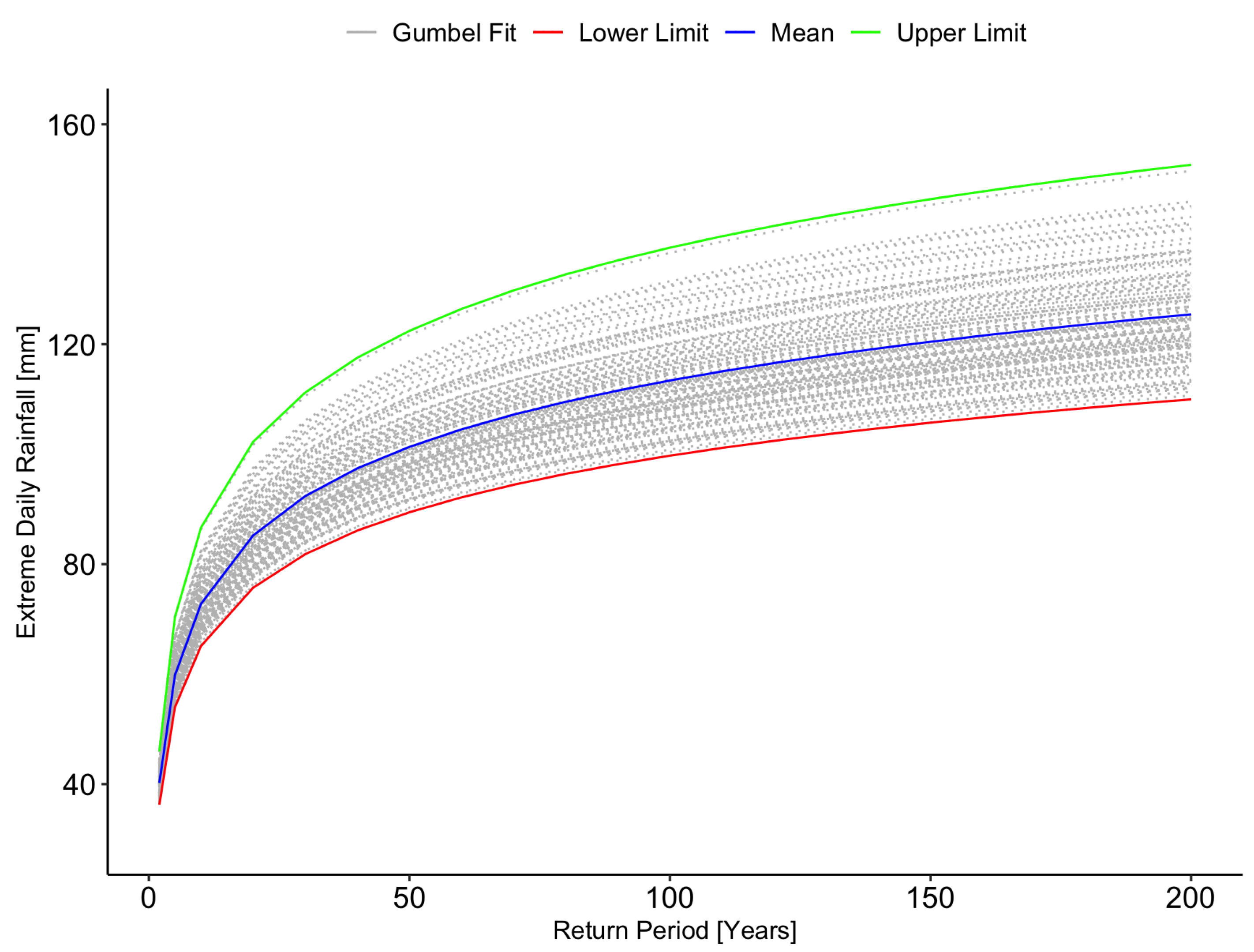
The EDR projections are limited by the assumption that a Gumbel frequency distribution can adequately represent the distribution of extreme rainfall under future conditions. The tendency for the Gumbel distribution is to yield the smallest possible rainfall, thus returning the highest possible risk in comparison to other extreme value distributions [
82]. The utilization of non-stationary generalized extreme value (GEV) distributions results in monthly resolved return levels and more precise estimations of return levels [
63,
64]. The introduction of a multi-distribution approach increases the robustness of the bias correction transfer functions in representing varying EDR distributions across the study area [
31].
The bias-corrected results reflect the limitations inherent in the selection of GCM-RCM ensemble combinations. The variation in the ensemble CCFs suggests that a four-member ensemble is limited in producing converging projections for the late-21st century MSR. The limitations of climate model output responses to bias correction methods can be addressed with an expanded ensemble to decrease the uncertainty and create robust projections [
69]. The coefficient of variations between ensemble members suggests another limitation in the building of an ensemble with equal weight and without performance selection criteria. The derivation of a reliable ensemble projection is dependent on the selection and configuration of its members [
34,
35,
58,
83,
84]. Therefore, it is recommended that a wider ensemble of RCMs be considered through a selection procedure to assess the reliability of each member to be used to improve climate change projections.
6. Conclusions
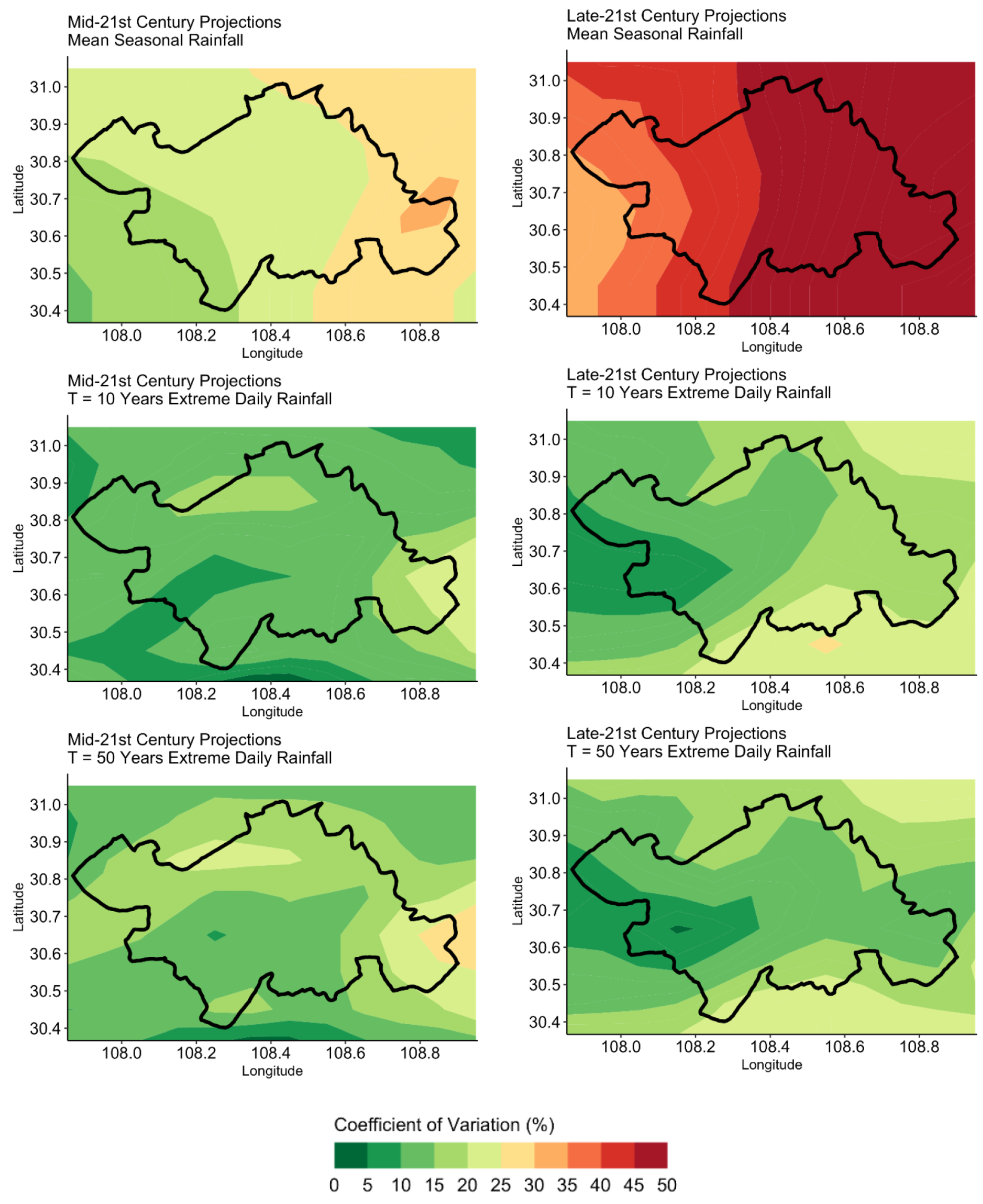
This paper presented a framework to derive future landslide-triggering rainfall scenarios from climate model outputs. A methodology following the framework was demonstrated through its application to the Wanzhou County, China. This study derived projections of extreme and mean seasonal rainfall scenarios for the mid-21st century (2021–2060) and the late-21st century (2061–2100) from bias-corrected RCM projections.
The MSR projections over Wanzhou County increased in the mid-21st century, measured by a range of between 1.0 and 1.4. The projected in the late-21st century ranged between 1.2 and 1.8. It was found that the variation in in the mid-21st century projections was between 10% and 35%. The uncertainty in the projections of the late-21st century ranged from 30% to 50%. The EDR ensemble projections indicated a decrease in the magnitude in the mid-21st century. The uncertainty in the ensemble projection for in mid-21st century and late-21st century scenarios was measured with a coefficient of variation between 5% and 25%.
The results of this case study delivered a proof-of-concept for a methodological framework to derive future rainfall scenarios under climate change conditions. The climate change factors (CCFs) derived for the mid-21st century and late-21st century scenarios in
Table 6 can be applied as a multiplicative factor to the present rainfall-scenario-derived observation data sets. This study integrated the measurement of the performance of the bias correction and quantification of the model ensemble uncertainty in the presentation of the projections. The results of this framework can aid in the incorporation of future rainfall scenarios in incorporating the impact of climate change in future hazard assessments.


 ,
, 


