Abstract
Mining activity has one of the most fundamental influences on the landscape (in terms of both aesthetics and use). Its activity and manifestations, even when mining takes place underground, have visual manifestations on the surface. The impact of subsurface mining has a synergistic effect on the elements of the landscape structure. This manifestation is continuous in the context of mining intensity. Using the Earth remote sensing method, we identified several fundamental changes. The most significant of these was the creation of wetlands and the modification of watercourse lines. In the area in which there was no permanent water sources, several water areas with a total area of more than 30 ha were created. We also found that the length of watercourses has halved, the area of grassland has doubled, and urban area has decreased. It was the creation of water areas that supported not only better ecological stability of the landscape, but also the growth of biodiversity. Wetlands can be a dynamic element of future development. Understanding the development of land-cover changes is necessary for the purpose of planning nature and landscape conservation, as well as to identify areas of conflict with economic use.
1. Introduction
Land-cover changes, as well as the speed and intensity of changes, are the result of various human activities. One of these activities is surface and underground coal mining; therefore, we can include mining and industrial landscapes in the category of fossil and relict landscapes [1]. The mapping of land-cover changes of mining areas using aerial photography and satellite imaging results provides us with basic information on the landscape character [2,3,4,5,6,7,8,9]. The effects of underground coal mining on the landscape are similar in all regions with favorable geological predisposition, such as the Czech Republic [10,11,12], Poland [13,14], and Germany [15,16,17]. The impacts manifest themselves in various ways, such as interventions in the relief of the territory, disturbing the aesthetics of the landscape, and deforestation of slopes; in densely populated areas, significant damages to houses and urban infrastructure occurs [18,19,20]. Coal mining causes enormous damage, which can have a significant impact on the environment with lasting changes [21,22,23,24,25,26]. This is a result of cumulative effects on the environment characterized by spatial and temporal overlay and interaction [27]. The knowledge of landscape utilization in different time periods reflects the changing human influence on the environment. Using both historical spatial and non-spatial data sources processed by means of GIS tools allows accurate measurement of the spatial distribution of landscape changes and their evaluation in relation to the socio-economic development of areas affected by coal mining [28,29,30,31].
Changes in land cover and land use are caused by interactions of environmental and socio-economic factors. There are a number of studies that analyze the impact of environmental factors on the dynamics of landscape [32,33], the influence of socio-economic indicators [34,35,36], or a combination of both [37,38,39]. Land cover integrated with geomorphological characteristics enables monitoring of the intensity of processes in the landscape. Due to significant structural changes to the dynamics of the landscape in recent years, some authors [40,41,42,43,44,45] have focused on understanding the relation between changes in landscape pattern and processes.
Analyzing landscape structure allows us to determine its characteristic spatial properties that predispose it to function, and also reflects development. When analyzing land-cover changes—and to better understand the relationship between spatial patterns and processes—indices have been developed which quantify spatial heterogeneity based on landscape composition [46,47]. The assessment of land changes in mining-affected localities is important for the design of further development, and has therefore been examined using remote sensing technologies and GIS [48,49]. It is possible to quantify the state in which changes are located through the assessment of environmental geofactors [50]; other options are the assessment of landscape vulnerability [51], the study of vascular plants and selected groups of animals [52,53], woody vegetation [54], or the use of ecosystem services [55]. In addition to assessing the state and development, it is important to determine how the country could develop using simulation models [56,57,58].
If mining activity is terminated and the state of the country is evaluated, events can proceed to the reclamation of the area. Reclamation processes are specific for each affected area and the extent depends on the objectives of their future use [59,60,61,62].
From 2023, the Slovak government will stop financially subsidizing coal mining, and by 2027, the mining and burning of brown coal in the region should be complete. This will significantly affect the socio-economic development of the region, and therefore it is necessary to know the trajectories of LC development. The choice of area was motivated by the specificity of the area for the creation of wetland ecosystems due to undermining.
The aim of this paper was to report the results and to evaluate the land-cover changes over the last 70 years in the Koš village cadastral area affected by underground coal mining. The agricultural character of the landscape predominantly responds to favorable natural conditions. Since the 1950s, the impact of mining activities has strangled economic and social development in the municipality, and has also caused land abandonment in the affected areas. The data obtained should form the basis of a data platform for proposing further land use.
2. Materials and Methods
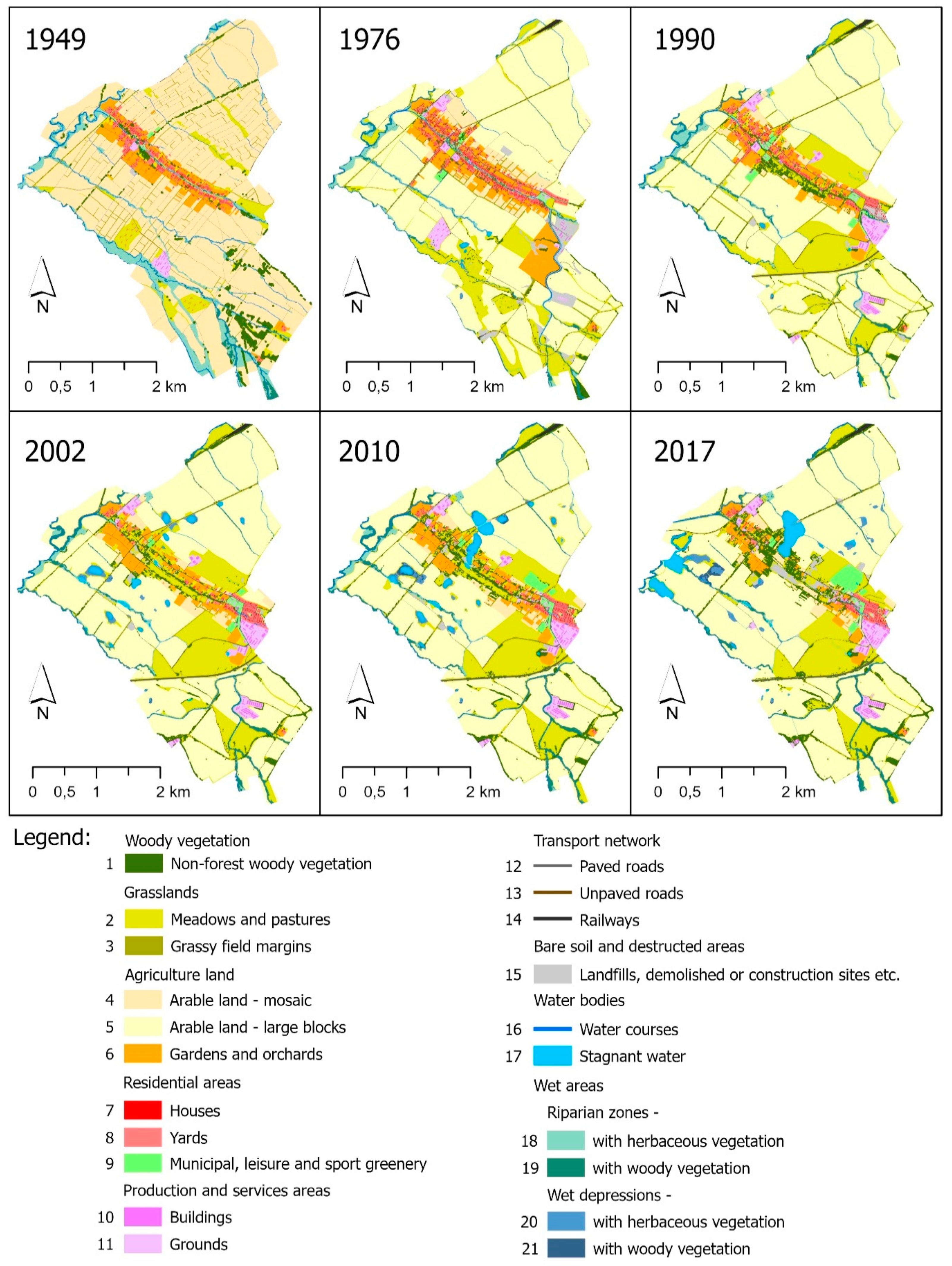
The research was based on GIS analyses, computer-aided visual photointerpretation of historical and recent orthophotos, and the production of a geodatabase with polygon vector layers of classified features by qualitative and quantitative information on land-cover spatio-temporal changes. We used manual digitizing, an accurate and easy option, especially for small-area studies where high resolution is important for identifying small features, or where important features are more easily distinguished by visual shape and pattern than by spectral distinction in remotely sensed imagery [63]. Moreover, the limited radiometric quality of historical grayscale imagery supported the decision to use visual photointerpretation techniques rather than automatic and semiautomatic ones [64]. The features representing land-cover elements were digitized in scale ~1:1500, with a minimum mapping unit (MMU) of ~10 square meters. A backdating principle was used during the manual photointerpretation and vectorizing process to maintain spatial integrity of the data [65]. Full coverage land-cover maps of the study area were produced for 6 temporal periods (1949, 1976, 1990, 2002, 2010, 2017) for which the very high-resolution geodata of ~1 m/pixel were available (Table 1, Figure 1 and Figure 2).

Table 1.
Characteristics of geospatial data sources and processing for land-cover classifications.
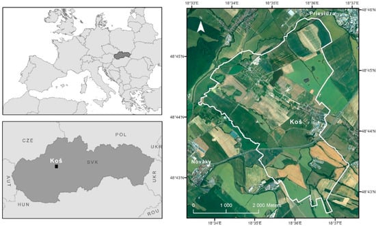
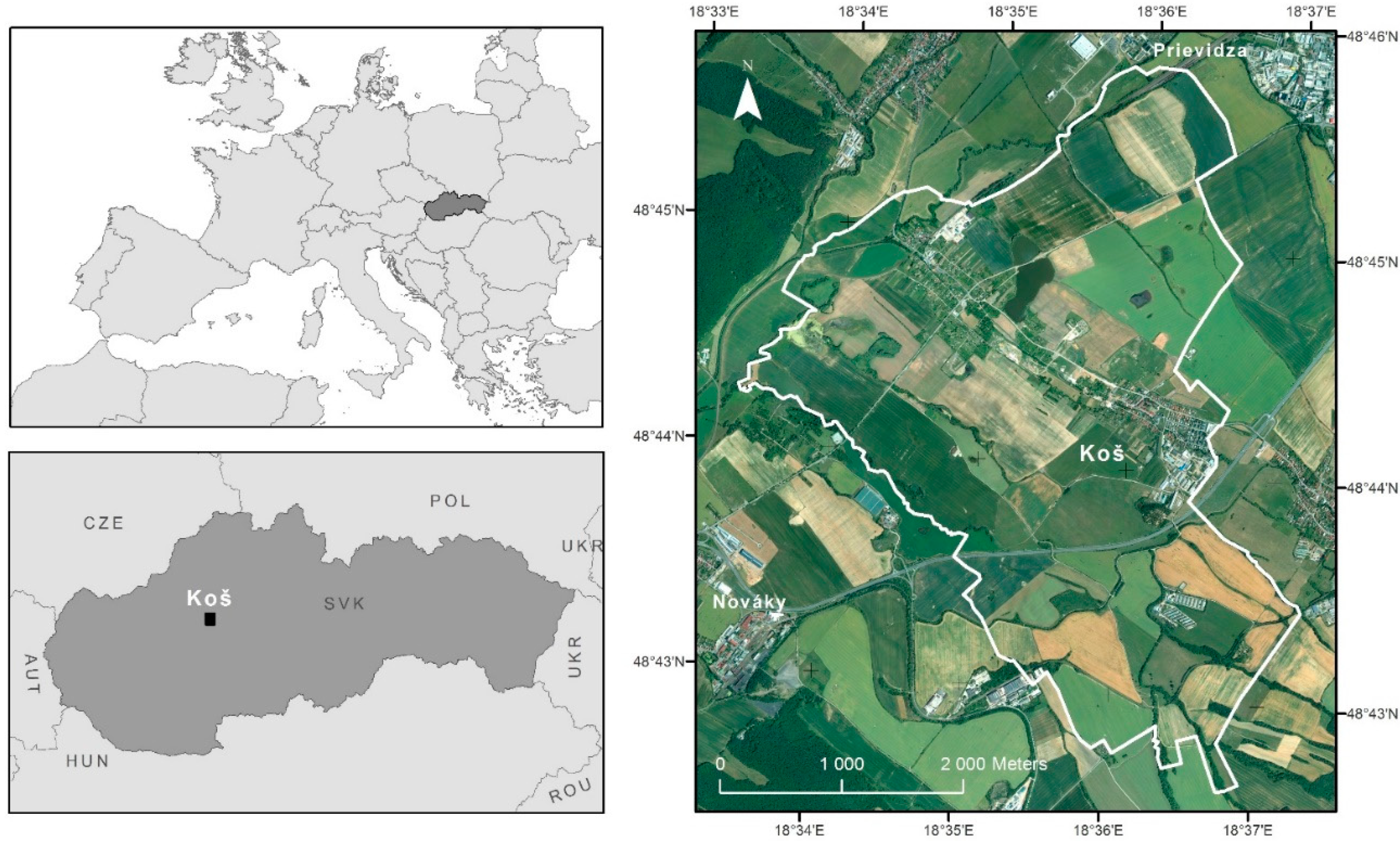
Figure 1.
Location of the study area.
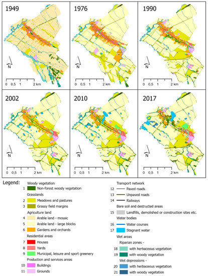
Figure 2.
Land-cover changes of study area.
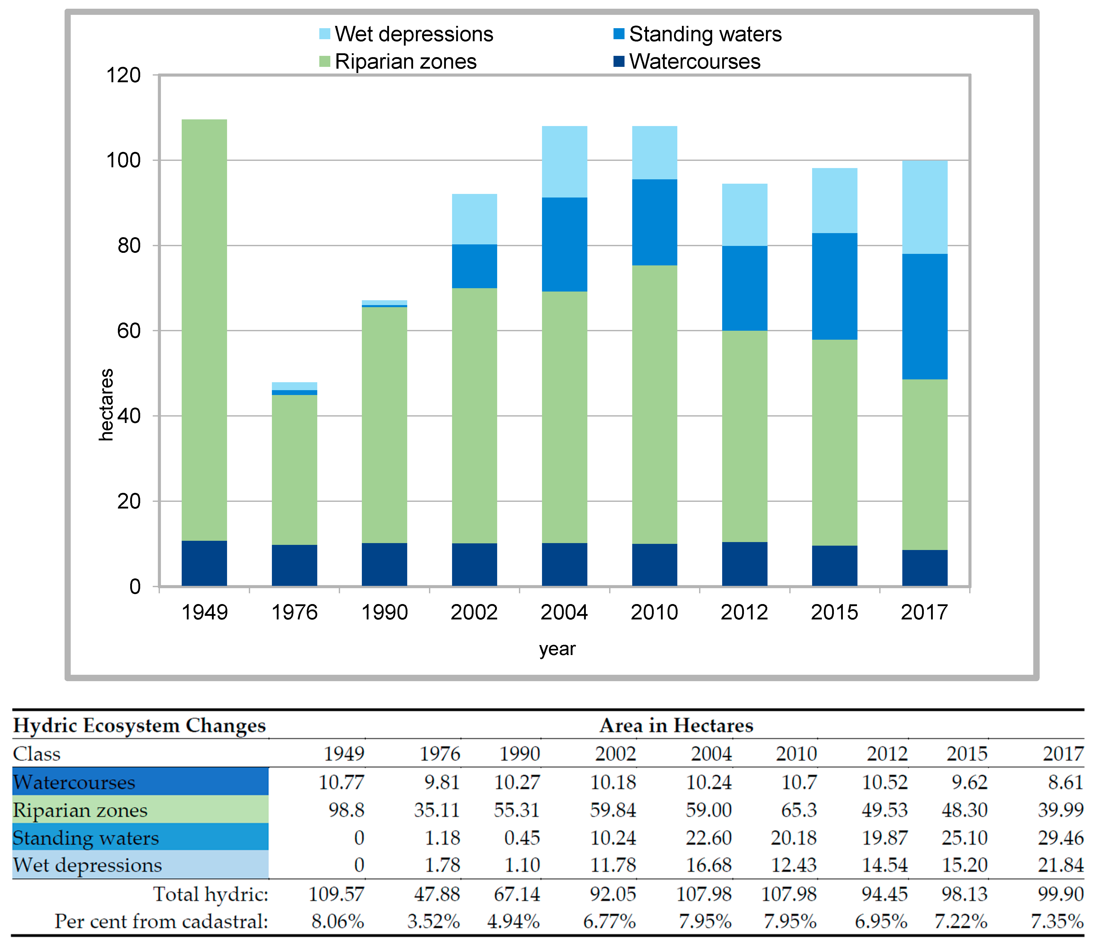
Rapid changes in hydric ecosystems observed in last two decades forced to include more geospatial data sources between years 2002 and 2017 for the analyses. For these, the hydric features were vectorized only (Figure 3).
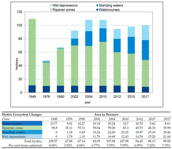
Figure 3.
Hydric ecosystem changes.
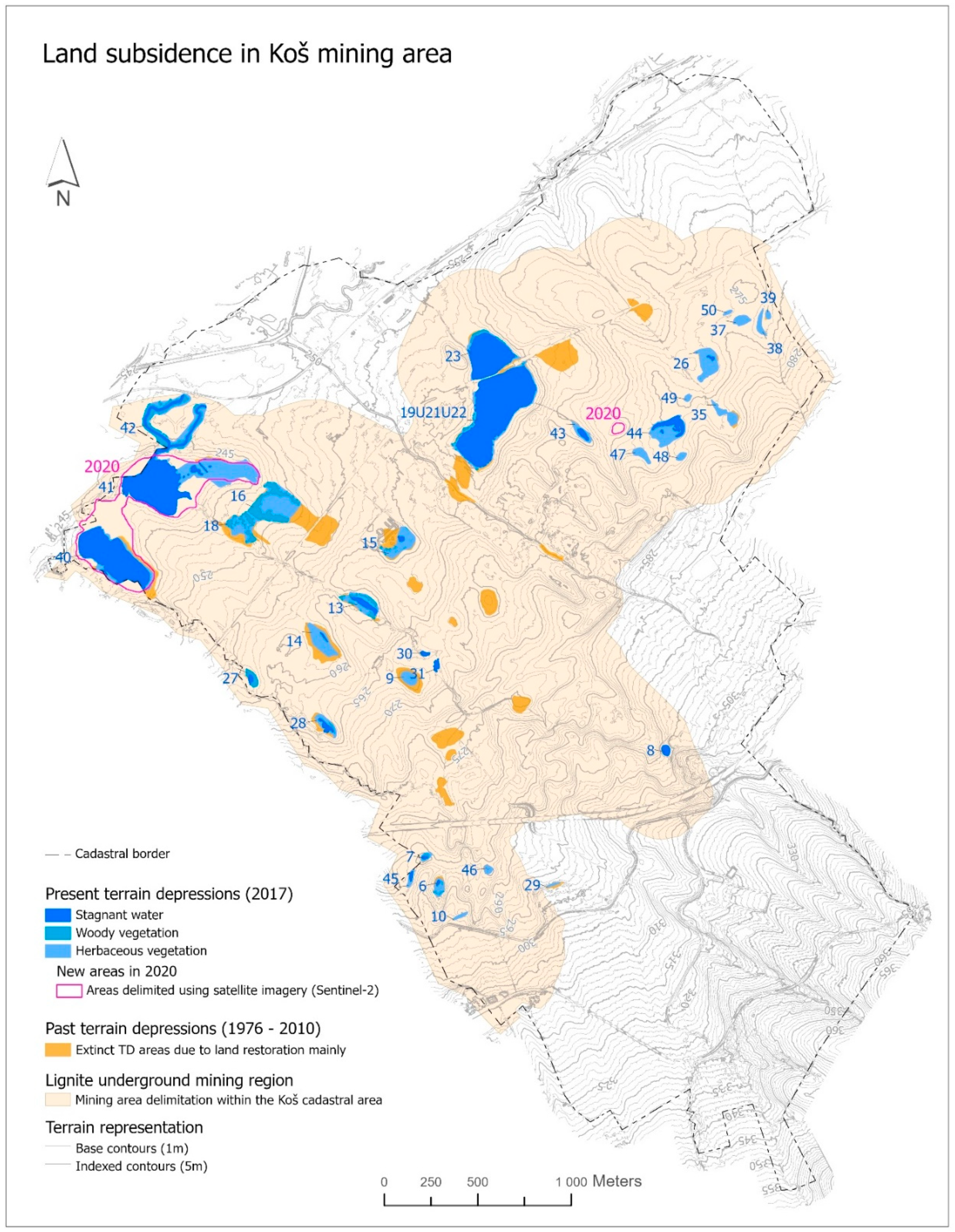
Since we did not have very high-resolution imagery of submeter spatial precision available by the time of finishing the research, the Sentinel-2 data (captured in April 2020) of 10-metre resolution was used to delineate newly generated water areas. This was made for illustrative purpose only, to point out the ongoing process of land-surface deformations (Figure 4).
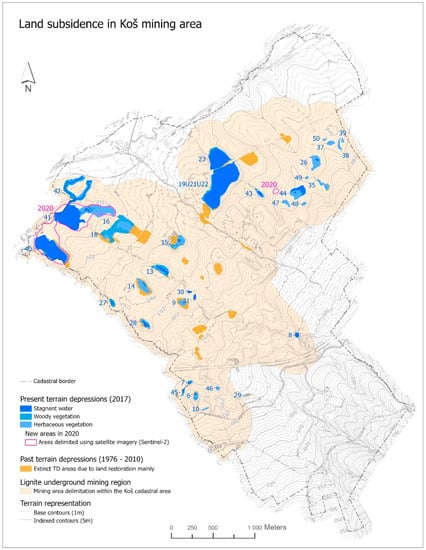
Figure 4.
Transformations of wetland in the research area.
The accuracy of land-cover photointerpretation was not evaluated quantitatively. Position errors were minimized using the backdating principle, where the “present” vector layer was used as the base for producing the historic one, by means of vector editing functions, final dissolving by land-cover code, and small feature eliminating (less than MMU) using the longest border option. To minimized classification errors, a cross-check interpretation of classified land-cover features was performed with ancillary information sources (Table 1).
Data sources:
Geospatial data used in this research included historical BW aerial images, color orthophotos, DEMs, topographic maps, and open-source vector and raster data. For this study, the aerial photography provided the geoinformation of the highest spatial detail of around 1 m/pixel throughout the whole analyzing period of 70 years. Detailed characteristics of the used data and processing are summarized in Table 1.
Used software:
LPS Core® module of Leica Photogrammetry Suite 9.2® (Leica Geosystems AG, Part of Hexagon) was used for the orthorectification of historical aerial photos (1949, 1976, and 1990). Prior to orthorectifying images, radiometric corrections were performed using the Leica Image Equalizer® module to improve grayscale balance and remove vignetting, especially on 1949 images.
ArcGIS Pro® (ESRI, Inc.) tools for creating and editing vector data were used for the land-cover map production for all classified years. Spatial statistics of GIS layers were obtained by means of zonal functions in the Spatial Analyst toolbox. Map layouts were also produced in ArcGIS Pro.
The selected landscape metrics (Shannon’s Diversity Index and Shannon’s Evenness Index) were calculated in ArcMap 10.8 with the extension Patch Analyst 5.2.
Further quantitative interpretations, statistics, and visualization of the results were performed in MS Excel 365.
2.1. Coefficient of Ecological Stability of the Landscape
Several methodological tools have been developed to express the level of ecological stability of a given area, most of which are based on the calculation coefficient of ecological stability (CES). A key concept in the process of assessing the ecological stability of a landscape and calculating the CES is ecological stability, which Michal [66] defines as the ability of ecological systems to persist even during exposure, to preserve and reproduce their essential characteristics even in conditions of external disturbance. This ability is manifested by a minimal change during the effect of interference (resistance) or a spontaneous return to baseline, respectively, to the original developmental trajectory after a possible change (resilience). This is a numerical value based on which the country is classified in a certain degree of ecological stability. CES is a key element in the design of land-use measures resulting from the proposals of local territorial ecological stability systems developed for landscaping projects. The CES calculation is used as a standard in the processing of various landscape ecological studies [67,68,69,70,71,72,73,74,75], in the spatial assessment of the landscape, etc. In practice, CES is used within territorial systems of ecological stability, as documentation of nature and landscape protection. ÚSES is also a part of various stages of spatial planning documentation as well as landscaping projects. At present, the practical application of the proposed methodological procedure for calculating CES is important, especially in landscaping projects. Changes in landscape elements during the development have an impact on the whole landscape structure as well as its ecological conditions and stability.
The ecological stability coefficient (CES) was determined according to Míchal [66]:
where CES—coefficient of ecological stability; PKp—the area of elements with stable or positive influence (woody vegetation, grassland, orchards, vineyards, gardens, urban vegetation, recreational and leisure areas, water bodies); PKn—the area of elements with unstable and negative influence (arable land annually ploughed, built-up areas without green urban areas and leisure areas); n—number of elements with positive influence; m—number of elements with negative influence on the landscape.
We interpreted the values of this coefficient as follows:
- -
- CES < 0.10—area with maximum disturbance of natural structures, basic ecological functions must be intensively and permanently replaced by technical interventions;
- -
- CES 0.10–0.30—above-average land use, with clear disturbance of natural structures;
- -
- CES 0.30–1.00—land intensively used mainly by large-scale agricultural production, weakening of self-regulatory processes causes their considerable ecological lability;
- -
- CES > 1.00—almost balanced country, in which the technical objects are relatively in line with the preserved natural structures.
2.2. The Selected Landscape Metrics (Shannon’s Diversity Index and Shannon’s Evenness Index)
Determination and evaluation of the landscape diversity and biodiversity represents an important process of the landscape changes and its element research. The Shannon diversity index (SDI) is a generally accepted method to obtain basic information about time and space changes in land use. The diversity index allows a relatively large scale for the interpretations but, on the other hand, has the problem of objectively assessing important changes that have happened. Determining diversity change is very valuable for knowledge regarding ecosystems and habitats, because it indirectly reflects the intensity of the socio-economic activities on the landscape.
The index is used to compare different landscape units or compare different time horizons. Shannon’s diversity index quantifies landscape diversity in terms of the number of different patch types and the proportional area distribution of patch types. The index grows with the growth of different patch type numbers or with the growth balanced proportional arrangement area between groups of the elements. The maximum of Shannon’s index for the exact number of element groups is the case of all element groups in a similar representation. The value of the Shannon index grows with ascending number of spots and/or with ascending balance of proportional distribution of the area among the group of spots.
The Shannon’s Evenness Index (SEI) expresses the distribution of landscape features in an area. It is complementary to the Shannon Diversity Index (SDI). It expresses the balance of species according to land cover in the community. The index of the evenness is calculated as the ratio of observed diversity to maximum diversity of the landscape elements. The Shannon’s Evenness uniformity index ranges from 0 to 1.
The landscape metrics (Shannon’s Diversity Index and Shannon’s Evenness Index) were calculated in ArcMap 10.8 with the extension Patch Analyst 5.2 [76].
3. Study Area
The village of Koš is located between the towns of Nováky, Bojnice and Prievidza (district of Prievidza, Trenčín Region). The cadaster has an area of 1358 ha (Figure 1). Koš is located in the central part of the Upper Nitra basin. The Upper Nitra Basin as an inland basin located in the Fatra-Tatra region of the Western Carpathians [77]. The altitude in the center of the village is 262 m above sea level. The cadaster of the municipality ranges from 242 to 412 m above sea level.
The development of the population of the village of Koš, in terms of historical development, was influenced by one main factor, namely the building closure due to the location of lignite under the village in the lower part of the built-up area (Table 1). The village of Koš is a settlement fatally affected by underground coal mining. Despite this, there is still certain potential for development, which has been especially recognized in the last decade. The cadastral area lies in the Prievidzská basin, rich in brown coal deposits of the Handlová–Nováky coal field, where underground mining was activated in 1940. The main coal seam is situated at a depth of 20–250 m, with thickness from 2.5 to 28.5 m. Mining techniques have induced upper bed subsidence, affecting various forms of tensile cracks, terrain depressions, and surface pits [78]. In the investigated area, hydrogeological units are represented by irrigated clastic sediments of the Quaternary, irrigated tuffites of the coal seam, and a limestone–dolomitic complex [79]. In 1950, a building prohibition valid for the western part of the village was proclaimed due to the detection of a new lignite deposit. Surface deformations occurred in the northwest part of the cadastral area and partly damaged local roads, restricting work on agricultural land. During the 1980s and 1990s, the affected part of the village was evacuated with subsequent changes in land use (Table 2). Since 1990, as the mining process proceeded, new depressions appeared on the surface, changing hydrological conditions favorable for a generation of wetlands and small lakes. This rapid rate of land-use change was remarkable, especially from an ecological point of view. Recently, continuing mining progress further to the west induced a relocation of the Nitra riverbed.

Table 2.
Development of the population of the Koš village.
4. Results
- 1949
In 1949, the village of Koš was a typical agricultural settlement (Figure 3, Table 3). Arable land (mosaic) was the dominant element of the landscape with more than 72% (981 ha) of cadastral area. The narrow fields were arranged vertically on the central axis of the area—the Ciglianka stream. In its vicinity, the residential areas with house gardens were located, representing 6.3% area of the cadaster. Permanent grasslands (meadows and pastures) were the second largest element in terms of area, accounting for almost 7% (residential areas—2.44%; gardens and orchards—3.78%), which represented an area of 94 ha. Local watercourses were mostly surrounded by grasslands, the largest areas were located in the southern and northeastern part of the village. Several watercourses flowed through the area, due to the Nitra River with a tributary of the Handlovka River in the northwestern part. Riparian zones were identified in the vicinity of watercourses, on an area of more than 10% (139 ha). We did not find any places with wet depressions directly in the area. Production and service areas represented by the areas of the agricultural cooperative (0.79%) were located in the western part of the area.

Table 3.
Land-cover changes from 1949 to 2017.
- 1976
The exploitation of the Nováky coal deposit below the village forced the construction closure of the lower part of the village towards the Handlovka River (northern part of the cadastre) as early as 1950. The nature of land use in 1960 was already influenced by political and economic changes after 1948 and the subsequent collectivization of agricultural land. By far, the largest part in this period was occupied by Arable land, which was changed into large blocks (up to 831 ha) and occupied 61% of the cadaster area (Figure 3, Table 2). Arable land as mosaic had been preserved to a small extent (4% of the cadaster—56 ha) only in the vicinity of the house gardens, which increased slightly to 6.4% (86 ha). The grasslands group covered an area of 167 ha (12%), of which meadows and pastures accounted for the largest share. Their increase was related to the intensification of agriculture and the change in riparian zones to grasslands in the southern part of the territory. Residential areas increased to 3.5% (48 ha) despite the construction closure. Production and service areas also increased to 1.5% (21 ha), mainly due to the construction of new areas of the farmers’ cooperative in the south of the village and the construction of an industrial part in the northern part of the village by the Handlovka River. The collectivization of agriculture caused a decrease in riparian zones to 3.8% (51 ha). However, mining activity conditioned the emergence of wet depressions with an area of 1.83 ha (0.13%). We identified six lakes (Table 4).

Table 4.
Number of lakes in 1949–2017.
- 1990
In 1985, a remediation study was prepared for the municipality of Koš, which also determined the time stages of the demolition works and the disconnection of engineering networks from the purchased houses. Coal mining began on January 1, 1988, under the lower part of the former village. The house stock was demolished in this part of the village (Figure 3, Table 2). Residential areas fell to 2.3% (31 ha). This decrease was also confirmed in gardens and orchards 3.6% (49.4 ha), which followed the Residential areas. For arable land, large blocks increased slightly—62.7% (852.6 ha)—at the expense of arable land mosaic, which decreased by more than half compared to 1976 to 1.4% (18.9 ha). Grasslands grew to 16.8% (229 ha), mainly in the east part of the village. The largest increase was recorded in the production and services areas, which was almost doubled to 34 ha (2.5%). This development took place in the vicinity of the expressway, at the southeast of the village. During this period, woodlands in the vicinity of watercourses also increased slightly (1.6%). The mining company tried to eliminate the manifestations of mining activities in the locality by the liquidation of wet depressions on agricultural land (they were covered with mining waste). They decreased to 1.2% (0.13 ha) and the number of lakes decreased to 4 (Table 4).
- 2002
The share of residential areas continued to decline in 2002 (Figure 3, Table 2). They covered an area of 19.18 ha (1.4%). On the contrary, the production and service areas slightly expanded to 35 ha (2.6%). This landscape element was expanding in the area adjacent to the village towards the expressway. As the population increased slightly during this period, there was also a partial transformation of arable land (large blocks) to arable land (mosaic). Arable land (mosaic) grew to 29 ha (2.1%), mainly close to the yards. There was also a development of agriculture in the village (increase in area of orchards). It was during this period that wet depressions increased to 10.3 ha (0.7%) and their number increased to 22 (Table 4). They were clearly locally linked to the northern part of the territory under which the mining activity took place. The growth of woodlands to 25 ha (1.8%) was also linked to the surroundings of these wet depressions.
- 2010
Residential areas were already stable during this period (Figure 3, Table 2) and even increased slightly (19.7 ha). Arable land (large blocks) recorded a slight decrease at 797 ha (58.7%). This decrease occurred mainly in the vicinity of water bodies, where wetland parts were transformed into grasslands. Production and service areas also increased slightly to 36.3 ha (2.7%). On the contrary, parts of the orchard were transformed into grasslands and fell to 48.9 ha (3.6%). Wet depressions continued to grow to 15.8 ha (1.16%) and 27 localities. There was a connection of several localities in the central part and the creation of the largest wetland locality in the area.
- 2017
In the central part of the village, grasslands fell to 200 ha (14.7%) in the context of the expansion of sports facilities (22.1 ha—1.6%). Significant growth in the northwest part of the built-up area was recorded by bare soil and destructed areas, which increased from 8 to 19 ha. This was caused by the modification of the original mining area and the alignment of damaged buildings in the fallen areas. The area of orchards in the central part continued to decrease to 33 ha (2.4%). Wet depressions increased by one locality to 28, but with an area of up to 24.5 ha (1.8%). This increase occurred mainly in the northwestern part, where there were more significant declines in the terrain around the already existing wetland localities and their subsequent flooding.
Landscape change 1949–2017
The overall visual appearance of the country changed significantly. In 1949, the dominant narrow-banded fields in the mosaics, forming 982 ha (72%), fell to 25 ha (1.8%). On the contrary, in 2017, a large block arable land occupied 812 ha (59.8%) in the agricultural landscape, while in 1949 they were not identified at all. The rest of the agricultural land consisted of grasslands, which increased from 95 ha (14.7%) to 200 ha (14.7%). As a result of the eviction of part of the housing estate, living areas decreased from 33 ha to 17 ha. The seat originally located in the axis of the territory was located and developed only in the SE part in 2017. Areas of production and services with the development of main agriculture increased by 10 ha to 38 ha. The bare land and disturbed areas in the context of the liquidation part of the settlement increased from 1.9 ha to 19 ha. However, this fact is also important for the increase in water areas from 10 ha to 38 ha, mainly in the northern and western part of the territory, but Riparian zones decreased from 138 ha to 4 ha.
The ecological stability assessment according to Míchal [66] emphasizes the presence and scope of positive elements in the landscape regardless of their varied ecostabilizing properties. The changes in the study area over the course of 50 years were very dramatic.
CES confirmed the positive impact of mining activities on elements of the landscape structure. Areas of negative elements declined and, on the contrary, those of positive elements increased. CES values were in the category of the third interval, as an area intensively used mainly by large-scale agricultural production. From the beginning of mining, de-urbanization took place, which was reflected in the decline in built-up areas. Consequently, wetlands emerged in these areas as a positive element of ecological stability. These factors were also reflected in the gradual increase in CES (Table 5) from the start of mining until 2010, after which there was a slight decrease in wetland management in 2017, as they were covered by mining and mine management. At the moment, this form of management is no longer underway, and CES growth is again expected.

Table 5.
Coefficient of ecological stability of the landscape.
Monitoring the diversity of land cover allows for the monitoring of natural and anthropogenic processes taking place in the country and contributes to the objectivity of proposals for changes in land use. Provided that the input databases are regularly updated, it is possible to monitor the effects of the various ecostabilization measures in this way, as well as the effectiveness of the funds that will be used for this purpose. SDI confirms the positive impact of subsurface mining on increasing the number and area of new elements in the area (wetlands, riparian vegetation), despite the homogenization of the landscape at the time of the collectivization of agriculture. Table 6 shows, with the exception of 1990, a continuous increase in SDI values, which confirms the increase in the number and area of mainly wetlands. The growth of SDI is also supported by the growth of SEI, which confirms the increase in the diversity of the country under study.

Table 6.
Landscape metrics—Shannon Diversity Index (SDI) and Shannon’s Evenness Index (SEI).
Hydric Ecosystem Changes
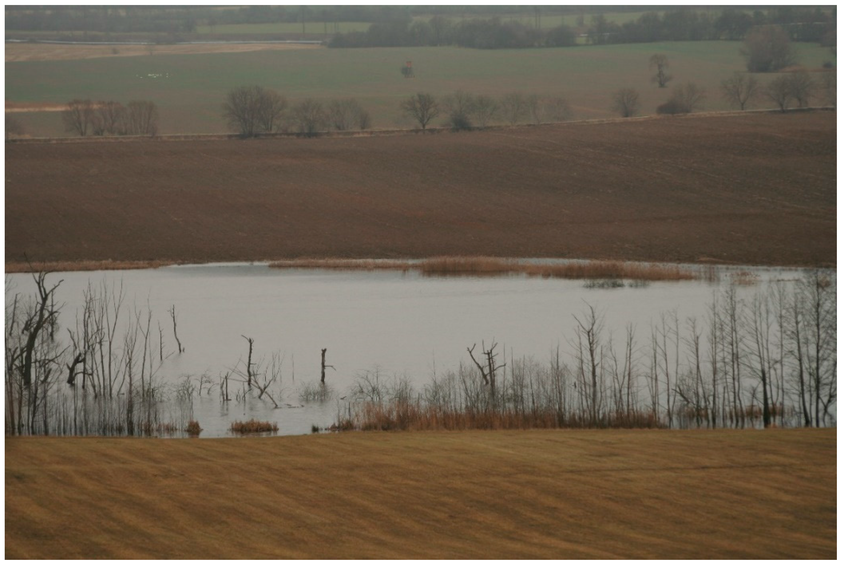
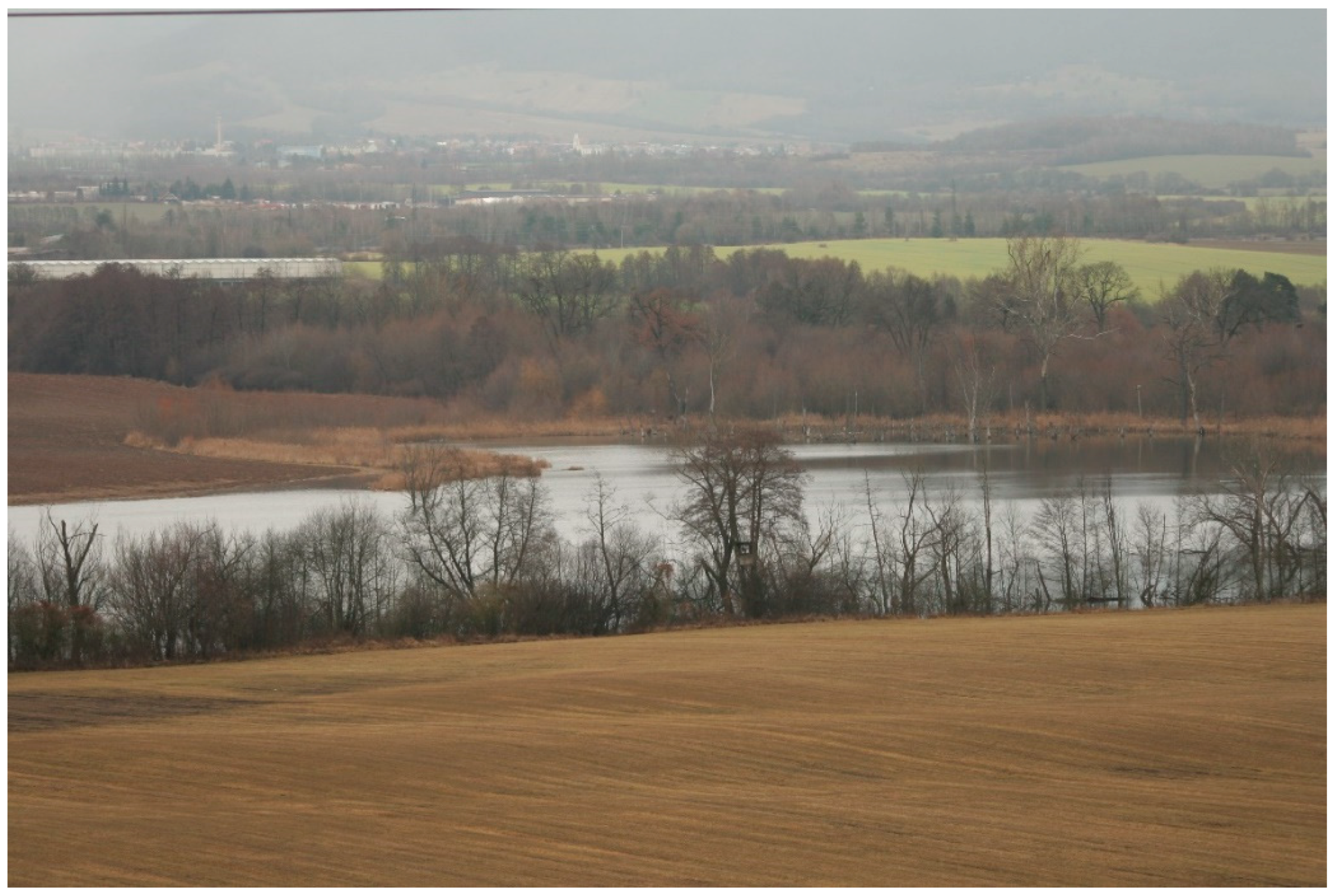
Water is a landscape element that is significantly influenced by man’s anthropogenic activity. The extent of changes may take the form of a direct impact on a particular habitat, or be a result of a secondary impact of land-use change. The researched area of the village of Koš cadastral area is clear proof of that. Four types of landscape habitats were selected to best capture the land-use changes of hydric ecosystems. By tracking changes in the nine time horizons, we tried to map the changes as accurately as possible. In 1949, the area was without significant anthropogenic interference. There were natural smaller watercourses (streams) with typical waterlogged localities, which is characteristic for habitats in the vicinity of unregulated watercourses. The habitats mentioned above had a dominant representation within the allocated hydric ecosystems (Table 6). The following decades were associated with changes typical of former socialist states, such as the creation of large-scale plots by merging narrow fields while at the same time regulating watercourses. This was reflected in the reduction in the riparian zone area to 1/3 of their original area. In 1990, the consequences of underground coal mining began to manifest themselves. The most significant feature was the disturbance of the geological strata above the mining fields, manifested by the emergence of depressions and by the disturbance of runoff processes. Land-use changes also affect groundwater level. Therefore, at the turn of the century, we recorded the emergence of new habitats—standing water and wet depressions (together, they occupied an area of about 22 ha in 2002). After 2002, with expanding underground mining, the areas of these habitats expanded to almost 51 ha (year 2017). Currently, there are 27 wet depressions in the cadastral area, although their number changes depend on where underground mining takes place in the area (Table 4, Figure 3, Figure 4, Figure 5 and Figure 6). It is assumed that water areas will increase, which has been confirmed by the added data from 2020 in Figure 4, in the western part of the territory where the largest body of water in the area was created.
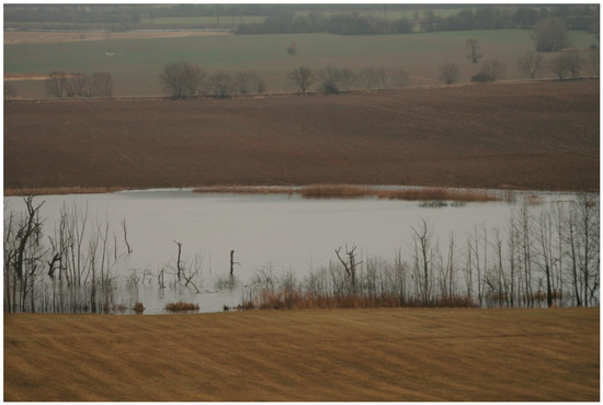
Figure 5.
The process of wetland formation is still ongoing.
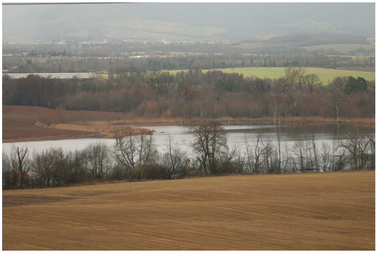
Figure 6.
Stabilized wetlands are beginning to be used for recreational purposes.
The intensity of the changes was also reflected in the qualitative parameters of surface water quality. The quality of surface water in the selected localities was significantly influenced by the age and area of the wetlands themselves. In the years 2007–2009, the measured pH values were in the range of 6.17–10.81, and conductivity values were between 16.56 and 245 mS.m−1. An important factor that influenced the hydrological regime of the area, and thus the quality of water and the level itself, was the part of the coal district that mined brown coal. The hydrological regime of the area was significantly affected by the reclamation processes of the wetlands themselves, but also by sites potentially threatened by declines. In these localities, soil weighing by a mining company was carried out as a preventive measure based on mining calculations. To a lesser extent, it was also the precipitation itself [80]. This also resulted in the high variability of water levels in wetlands [81].
5. Discussion
5.1. Evaluation Changes to the Mining Landscape
The evaluation of changes to the landscape structure and land use is necessary in terms of its further planning. Areas affected by coal mining are specific for their terrain diversity which, in the case of underground mining, results in terrain deformations in the form of subsidence [82,83,84,85,86,87,88]. If we compare the assessment of the development of landscape cover with other localities affected by mining activities in most cases, the country was negatively affected [89,90]. The evaluation of the LCLU (land cover and land use) development of the studied area can be divided into four phases [91]. The first phase represents the period before the start of mining. The development of the landscape was identical with other comparable areas with the same natural and ecological conditions. After the Second World War and collectivization, there was an intensification of agriculture and the number of inhabitants in the village grew significantly. The changes occurred after the decision to start intensive underground mining in the area, which is associated with significant interventions represented by the displacement of the population and interventions in hydrological regimes in the area. At the beginning of the second phase (the period between 1960 and 1990) the transformation of the LCLU was followed continuously by changes resulting from underground mining itself. Development here between 1960 and 1990 was similar to that in other regions with the characteristic processes of urbanization, agriculture intensification of crop cultivation, and extensification due to extending grazing areas [92]. At the end of the 1980s, there was a process of de-urbanization caused by a legal limitation on housing development; this was the only deviation with a great spatial extent, significantly affecting development in areas affected by coal mining [82].
Several studies carried out in coal mining regions show that the effects on environment, landscape, and species diversity can also be favorable. This is especially apparent in the development of subsiding terrain depressions, as new quasi-natural biotopes increase the total balance of natural species. However, this applies principally to water and hygrophilous biotopes [13]. Besides the wetland generation, there were other important processes with environmental impacts during 1960–1990, e.g., agriculture intensification affecting landscape connectivity. The disturbance of hydrological processes by removing and regulating water stream beds weakened landscape functions, which is exceedingly common in mining regions [13,87,88]. In the following phase, we included a period when the processes and changes to the territory were no longer so intense; we can state that the country entered a certain transition period, i.e., it did not fulfil its original function because anthropogenic influences were predominant. During the period 1990–2008, the ratio of the main processes changed. Although the predominance of intensification and extensification still persisted, the extent of urbanization and de-urbanization decreased. Extensification and land abandonment in this period represented an opposing process to the intensification of the previous period, although this was not so spatially extensive. Intensification also took up space, but this had a different origin. Unlike past expressive land unification, this process was actually more connected with changes from intensive pastures to arable land, owing to a decrease in livestock breeding in this region. Besides ecological influences, the effects of changes in landscape utilization upon the social and economic situation of the region was also obvious [93,94,95,96,97]. Delimited areas of de-urbanization and urbanization reflect the processes of resettlement, including demolitions, new housing constructions, loss and/or changes of jobs, and changes in environmental quality [11,15]. In contrast, some positive effects of underground coal mining emerged in relation to biodiversity. Due to subsoil subsidence, a number of terrain depressions were generated, changing hydrological conditions and making them wetland friendly. The results of a study carried out by Svitok et al. [81] confirmed the rapid development of vegetation in depressed wetlands within an agricultural landscape. In addition to successive changes, the average depth of water and conductivity also plays a significant role in shaping the diversity and species composition of wetlands. Besides this phenomenon, several other processes affecting the landscape structure were identified by classifying land-cover changes. Thus, the side effects of mining have been fully demonstrated in newly generated wetlands, with open water bodies and adjacent wet areas together composing the third largest type of land-cover change known as “swamping”.
The last phase began with the start of the reclamation processes in the affected area. Currently, mining progress continues with attendant effects on the landscape. In 2008, the Nitra and Handlovka riverbeds were transposed, and so was a portion of the railway to Prievidza. In addition, some of the existing wetlands were reclaimed by means of backfill to reconstruct the state that existed before the mining influence (Figure 4). Due to the changed hydrological conditions, but also the implemented anthropogenic interventions, there was an insufficient water supply in some wetlands, which caused drying out. Gradual development leads to the degradation of littoral vegetation [98]. The changes in the period 2008–2017 are a reflection of the underground mining in the new coal district, located below the northwestern and western part of the cadastral area. Mining calculations assume the creation of new terrain depressions with subsequent flooding over an area of 58 ha, which will continue to significantly change the land cover over a relatively short period of time [80]. The decrease in the length of watercourses is crucial. In 1949, the length was 38.69 km; in 2017, a decrease of half (21.4 km) could be seen. This trend was also confirmed by our research (Figure 4).
5.2. Managed versus Spontaneous Succession Restoration
The key task of land-use planning for an affected area in the short, but especially in the long term, is to establish a land-use strategy [87,95]. The proposal for a future zoning plan must be based on the agreement of all parties involved—the mining company, the government, and the local government—in order to take measures that will ensure the long-term sustainability of ecosystems established on mined land. Case studies of brownfield regeneration and redevelopment require problem solving related to urban structures, but they must also combine environmental, socio-economic, and cultural aspects [99,100,101]. The use of model software in a GIS environment for the quantitative assessment of landscape impacts seems to be a suitable tool for the design of reclamation plans [102,103,104]. Analyses of proposed reclamations from other post-mining areas highlight the demand to take into account and support the landscape heterogeneity and biodiversity of the area through ecological networks [105,106,107].
There are two basic approaches to reclamation. The first approach is to leave the site to self-development with as few anthropogenic interventions as possible. An example of this is the territory of Schlabendorf, located in the Lower Lusatia region of Germany [108]. The second approach is planned reclamation. A comprehensive proposal for the managed reclamation of a mining area should ensure a balance between environmental and economic aspects (61). If two different approaches are combined, conditions can be created for comparing developments in reclaimed and non-reclaimed localities affected by mining activities.
According to a study conducted in the Czech Republic, it has been confirmed that, in terms of diversity, primary succession leads to a more preferable environment for amphibians compared to reclaimed water bodies [109]. Therefore, the unilateral goal of reclamation should not be to modify the terrain to the original state of the landscape, as rare wetland ecosystems have emerged in the study area. This is important because the most important factor in designing reclamation is often the economic aspect, and the ecosystem approach to the problem is often pushed to the background. The fundamental problem in such cases is that the ecological value of wetlands, as well as the value of ecosystem services, are not taken into account. The specificity of such areas affected by former coal mining is the influence of several environmental factors, which lead to the creation of different types of habitats, leading to intense dynamics of colonization of different groups of animals, such as Arthropoda [53,110], Heteroptera [111] or Odonata [54]. According to David [98], the economic benefit from the agricultural production of a reclaimed area (wetland) is several times lower than the legally determined value of the occurring protected plants and animals before reclamation. One of the ways to solve the problem is to legislate the allocated ecologically valuable sites within protected areas, giving a certain degree of protection, as is already the case in some EU countries [112]. By applying the given procedure to our researched area, the preservation of the newly created wetland ecosystems would be achieved to a substantial extent, and the area would gain the status of regional biocentres. The creation of conditions for the continuation of the processes of spontaneous development will mainly provide but also support the landscape–aesthetic function of the territory. This is another positive element, as the country’s visual side should be taken into account in spatial planning. Research in areas similarly affected by surface mining confirm the fact that the inhabitants of these areas are influenced by the visual perception of physical attributes of mining and post-mining landscapes. Individual landscape elements can be perceived positively, e.g., water areas and non-forest woody vegetation; however, on the contrary, technical elements related to mining and built-up areas are in most cases perceived negatively [113]. Awareness of these facts and the implementation of the knowledge in our research area can ultimately positively affect further socio-economic development.
The Horná Nitra Region (Slovakia), to which the research area belongs, will be one of the three pilot regions of the new Platform for Coal Regions [114,115], set up by the European Commission to work together and help find concrete solutions for their transformation.
The decline in lignite mining in Nováky, and thus also lignite mining in this region, is approved until 2023. Slovenské elektrárne (SE), for which coal is mined, has long emphasized that the operation of the Nováky power plant is unprofitable for them, and they operate only due to a government decision that obliged them to produce and also provide support services. According to SE, the Novácka power plant is morally obsolete in spite of the investments made in 2015, which increases its failure rate. The company assumes that this will cause more and more need for repairs and maintenance, which will cause a decrease in the planned supply of electricity. Therefore, after 2023, SE does not anticipate further operation due to the technical life of the power plant.
6. Conclusions
The Novácko–Košské wetlands are a special element of the created landscape. They are a direct consequence of deep coal mining in the Nováky deposit. At present, from an ecology viewpoint, it is possible to characterize this area as a locality with the most intensive biodiversity within the inner Carpathians of the Slovak Republic. Depressions, flooded and transformed into wetlands, together with spontaneous woody vegetation, are positive elements of the scenery of otherwise monotonous large-scale fields, and give the landscape a new specific character. This creates an ideal opportunity to preserve the newly created landscape elements to optimize the use of the landscape, and has the potential to be perceived positively from a visual point of view.
Based on the information obtained, it is necessary to focus on the implementation of the following key proposals:
- -
- Given the existing legislation, we would propose to preserve those wetlands that have a conservation perspective for the future. The basic criterion should therefore be whether the wetland is connected to watercourses in order to ensure the supply of water to the wetland ecosystems;
- -
- Revitalization of depressed areas on which grounding was carried out. Focus on locations where there was individual housing construction in the past;
- -
- Optimization of ownership of land (redemption into state ownership) that has been affected by mining activities and will no longer fulfill the original land use (especially wetland ecosystems);
- -
- Design management measures for wetland ecosystems such as habitats of anthropogenic origin. Conditions will be created for maintaining landscape diversity;
- -
- Construction of an educational trail for educational activities and relaxation use, as the area is located near the towns of Prievidza, Nováky and also the spa town of Bojnice.
For a fair transformation of the Upper Nitra region, we need to engage local, regional and national representatives in a professional debate. We will gain valuable cooperation that will help overcome the challenges of transformation in this region. Thanks to the European Union and the willingness of several representatives, the Upper Nitra can thus become an example of how to prevent social and environmental problems. This change has already taken place in the region, as exemplified by the professional debate and the proposal to declare part of the territory (NW part) a protected site. The results of this study alone provide the basis for sustainable management, environmental planning or environmental impact assessment and environmental planning, which can be applied to sites equally affected by mining activities.
Author Contributions
Conceptualization, M.M., F.P. and G.B.; methodology, F.P. and G.B.; formal analysis, F.P. and G.B.; data curation, G.B.; writing, F.P. and M.M.; visualization, F.P. and G.B.; supervision, F.P.; project administration, M.M. and F.P.; funding acquisition, F.P. All authors have read and agreed to the published version of the manuscript.
Funding
This research was funded by Scientific Grant Agency of the Ministry of Education, Science, Research and Sports of the Slovak Republic and the Slovak Academy of Sciences, grant number VEGA 2/0018/19 and Cultural and Educational Grant Agency of the Ministry of Education, Youth and Sports of the Slovak Republic (KEGA) number 043UKF-4/2022.
Institutional Review Board Statement
Not applicable.
Informed Consent Statement
Not applicable.
Data Availability Statement
Data used in this contribution are from public resouces cited in the article.
Conflicts of Interest
The authors declare no conflict of interest.
References
- Antrop, M. Sustainable landscapes: Contradiction, fiction or utopia? Landsc. Urban Plan. 2006, 75, 187–197. [Google Scholar] [CrossRef]
- Sklenička, P.; Charvátová, E. Stand continuity- a useful parameter for ecological networks in post-mining landscapes. Ecol. Eng. 2003, 20, 287–296. [Google Scholar] [CrossRef]
- Townsend, P.A.; Helmers, D.P.; Kingdon, C.C.; McNeil, B.E.; de Beurs, K.M.; Eshleman, K.N. Changes in the extent of surface mining and reclamation in the Central Appalachians detected using a 1976–2006 Landsat time series. Remote Sens. Environ. 2009, 113, 62–72. [Google Scholar] [CrossRef]
- Demirel, N.; Düzgün, Ş.; Emil, M.K. Landuse change detection in a surface coal mine area using multi-temporal high-resolution satellite images. Int. J. Min. Reclam. Environ. 2011, 25, 342–349. [Google Scholar] [CrossRef]
- Skaloš, J.; Kašparová, I. Landscape memory and landscape change in relation to mining. Ecol. Eng. 2012, 43, 60–69. [Google Scholar] [CrossRef]
- Wu, W.-B.; Yao, J.; Kang, T.-J. Study on land use changes of the coal mining area based on TM image. J. Coal Sci. Eng. 2008, 14, 287–290. [Google Scholar] [CrossRef]
- Hu, X.; Hassink, R. Exploring adaptation and adaptability in uneven economic resilience: A tale of two Chinese mining regions. Camb. J. Reg. Econ. Soc. 2017, 10, 527–541. [Google Scholar] [CrossRef]
- Chudý, F.; Slámová, M.; Tomaštík, J.; Prokešová, R.; Mokroš, M. Identification of Micro-Scale Landforms of Landslides Using Precise Digital Elevation Models. Geosciences 2019, 9, 117. [Google Scholar] [CrossRef]
- Gallay, I.; Olah, B.; Gallayová, Z.; Lepeška, T. Monetary Valuation of Flood Protection Ecosystem Service Based on Hydrological Modelling and Avoided Damage Costs. An Example from the Čierny Hron River Basin, Slovakia. Water 2021, 13, 198. [Google Scholar] [CrossRef]
- Martinec, P.; Schejbalová, B. History and environmental impact of mining in the Ostrava—Karvina coal field (Upper Silesian coal basin, Czech Republic). Geol. Belg. 2004, 7, 215–223. [Google Scholar]
- Mulková, M.; Popelka, P.; Popelková, R. Landscape changes in the central part of the Karviná region from the first half of the 19th century to the beginning of the 21st century. Ekol. Bratisl. 2012, 31, 75–91. [Google Scholar] [CrossRef]
- Kunc, J.; Martinát, S.; Tonev, P.; Frantál, B. Destiny of urban brownfields: Spatial patterns and perceived consequences of post-socialistic deindustrialization. Transylv. Rev. Adm. Sci. 2014, 41E, 109–128. [Google Scholar]
- Pełka-Gościniak, J. Restoring nature in mining areas of the Silesian Upland (Poland). Earth Surf. Process. Landf. 2006, 31, 1685–1691. [Google Scholar] [CrossRef]
- Krzysztofik, R.; Tkocz, M.; Spórna, T.; Kantor-Pietraga, I. Some dilemmas of post-industrialism in a region of traditional industry: The case of the Katowice conurbation, Poland. Morav. Geogr. Rep. 2016, 24, 42–54. [Google Scholar] [CrossRef]
- Antwi, E.K.; Boakye-Danquah, J.; Asabere, S.B.; Takeuchi, K.; Wiegleb, G. Land cover transformation in two post-mining landscapes subjected to different ages of reclamation since dumping of spoils. SpringerPlus 2014, 3, 1–22. [Google Scholar] [CrossRef]
- Spreckels, V. Monitoring of coal mining subsidence by HRSC-A DATA. In Proceedings of the IAPRS 2000, Volume XXXIII, Amsterdam, The Netherlands, 16–23 July 2000; pp. 1452–1458, (CD-ROM). [Google Scholar]
- Krümmelbein, J.; Bens, O.; Raab, T.; Naeth, M.A. A history of lignite coal mining and reclamation practices in Lusatia, eastern Germany. Can. J. Soil Sci. 2012, 92, 53–66. [Google Scholar] [CrossRef]
- Longoni, L.; Papini, M.; Brambilla, D.; Arosio, D.; Zanzi, L. The risk of collapse in abandoned mine sites: The issue of data uncertainty. Open Geosci. 2016, 8, 246–258. [Google Scholar] [CrossRef]
- Loupasakis, C.; Angelitsa, V.; Rozos, D.; Spanou, N. Mining geohazards—land subsidence caused by the dewatering of opencast coal mines: The case study of the Amyntaio coal mine, Florina, Greece. Nat. Hazards 2013, 70, 675–691. [Google Scholar] [CrossRef]
- Sahu, P.; Lokhande, R.D. An Investigation of Sinkhole Subsidence and its Preventive Measures in Underground Coal Mining. Procedia Earth Planet. Sci. 2015, 11, 63–75. [Google Scholar] [CrossRef]
- Latifovic, R.; Fytas, K.; Chen, J.; Paraszczak, J. Assessing land cover change resulting from large surface mining development. Int. J. Appl. Earth Obs. Geoinf. 2005, 7, 29–48. [Google Scholar] [CrossRef]
- Fischer, C. Use of GIS and multitemporal imaging spectrometer data for modelling and mapping environmental changes in mining areas. In Proceedings of the Symposium on Geospatial Theory, Processing and Applications, Ottawa, ON, Canada, 9–12 July 2002; Available online: https://www.isprs.org/proceedings/xxxiv/part4/pdfpapers/350.pdf (accessed on 20 December 2021).
- Bian, Z.; Inyang, H.I.; Daniels, J.L.; Otto, F.; Struthers, S. Environmental issues from coal mining and their solutions. Min. Sci. Technol. 2010, 20, 215–223. [Google Scholar] [CrossRef]
- Wiegleb, G.; Felinks, B. Primary succession in post-mining landscapes of Lower Lusatia—Chance or necessity. Ecol. Eng. 2001, 17, 199–217. [Google Scholar] [CrossRef]
- Peh, N.; Plut, D. Sustainable landscape management in Slovenia: Environmental improvements for the Velenje coal mining community 1991–2000. GeoJournal 2001, 54, 569–578. [Google Scholar]
- Tokgoz, N. Case study of the Agacli landslide–gully complex during post-coal-mining reclamation and afforestation. Environ. Earth Sci. 2009, 59, 1559–1567. [Google Scholar] [CrossRef]
- Lei, M.; Qi-yan, F.; Lai, Z.; Ping, L.; Qing-jun, M. Environmental cumulative effects of coal underground mining. Procedia Earth Planet. Sci. 2009, 1, 1280–1284. [Google Scholar] [CrossRef]
- Akiwumi, F.A.; Butler, D.R. Mining and environmental change in Sierra Leone, West Africa: A remote sensing and hydrogeomorphological study. Environ. Monit. Assess. 2007, 142, 309–318. [Google Scholar] [CrossRef] [PubMed]
- Dawley, S.; Stennig, A.; Pike, A. Mapping Corporations, Connecting Communities: Remaking Steel Geographies in Northern England and Southern Poland. Eur. Urban Reg. Stud. 2008, 15, 265–287. [Google Scholar] [CrossRef]
- Kunzer, C.; Voigt, S.; Morth, D. Investigating land cover changes in two chinese coal mining environments using partial unmixing. In Remote Sensing & GIS for Environmental Studies; Erasmi, S., Cyffka, B., Kappas, M., Eds.; Göttinger Geographische Abhandlungen: Göttingen, Germany, 2005; Volume 113, pp. 31–37. [Google Scholar]
- Martinec, P.; Schejbalová, B.; Hortvík, K.; Maníček, J. The effects of coal mining on the landscapes of the Ostrava region. Morav. Geogr. Rep. 2005, 13, 13–26. [Google Scholar]
- Hietel, E.; Waldhardt, R.; Otte, A. Analysing land-cover changes in relation to environmental variables in Hesse, Germany. Landsc. Ecol. 2004, 19, 473–489. [Google Scholar] [CrossRef]
- Pan, D.; Domon, G.; de Blois, S.; Bouchard, A. Temporal (1958–1993) and spatial patterns of land use changes in Haut-Saint-Laurent (Quebec, Canada) and their relation to landscape physical attributes. Landsc. Ecol. 1999, 14, 35–52. [Google Scholar] [CrossRef]
- Hietala-Koivu, R. Landscape and modernizing agriculture: A case study of three areas in Finland in 1954–1998. Agric. Ecosyst. Environ. 2002, 91, 273–281. [Google Scholar] [CrossRef]
- Hietel, E.; Waldhardt, R.; Otte, A. Linking socio-economic factors, environment and land cover in the German Highlands, 1945–1999. J. Environ. Manag. 2005, 75, 133–143. [Google Scholar] [CrossRef] [PubMed]
- Kristensen, L.S.; Thenail, C.; Kristensen, S.P. Landscape changes in agrarian landscapes in the 1990s: The interaction between farmers and the farmed landscape. A case study from Jutland, Denmark. J. Environ. Manage. 2004, 71, 231–244. [Google Scholar] [CrossRef] [PubMed]
- Martínez, J.-M.; Suárez-Seoane, S.; Calabuig, E.D.L. Modelling the risk of land cover change from environmental and socio-economic drivers in heterogeneous and changing landscapes: The role of uncertainty. Landsc. Urban Plan. 2011, 101, 108–119. [Google Scholar] [CrossRef]
- Karlik, L.; Marián, G.; Falťan, V.; Havlíček, M. Vineyard zonation based on natural terroir factors using multivariate statistics—Case study Burgenland (Austria). OENO One 2018, 52, 105–117. [Google Scholar] [CrossRef]
- Weis, K.; Hroncek, P.; Tometzova, D.; Gregorova, B.; Pribil, M.; Jesensky, M.; Cech, V. Analysis of notice boards (panels) as general information media in the outdoor mining tourism. Acta Montan. Slovaca 2019, 24, 269–283. [Google Scholar]
- Calvo-Iglesias, M.S.; Fra.Paleo, U.; Crecente-Maseda, R.; Díaz-Varela, R.A. Directions of Change in Land Cover and Landscape Patterns from 1957 to 2000 in Agricultural Landscapes in NW Spain. Environ. Manag. 2006, 38, 921–933. [Google Scholar] [CrossRef]
- Petit, C.; Lambin, E. Impact of data integration technique on historical land-use/land-cover change: Comparing historical maps with remote sensing data in the Belgian Ardennes. Landsc. Ecol. 2002, 17, 117–132. [Google Scholar] [CrossRef]
- Tischendorf, L. Can landscape indices predict ecological processes consistently? Landsc. Ecol. 2001, 16, 235–254. [Google Scholar] [CrossRef]
- Muchová, Z. Assessment of land ownership fragmentation by multiple criteria. Surv. Rev. 2017, 51, 265–272. [Google Scholar] [CrossRef]
- Kubínsky, D.; Weis, K.; Fuska, J.; Lehotský, M.; Petrovič, F. Changes in retention characteristics of 9 historical artificial water reservoirs near Banská Štiavnica. Slovakia. Open Geosci. 2015, 7, 880–887. [Google Scholar] [CrossRef]
- Petrovič, F.; Stránovsky, P.; Muchová, Z.; Falťan, V.; Skokanová, H.; Havlíček, M.; Špulerová, J. Landscape-ecological optimization of hydric potential in foothills region with dispersed settlements—A case study of Nová Bošáca, Slovakia. Appl. Ecol. Environ. Res. 2017, 15, 379–400. [Google Scholar] [CrossRef]
- Wrbka, T.; Erb, K.; Schulz, N.B.; Peterseil, J.; Hahn, C.; Haberl, H. Linking pattern and process in cultural landscapes. An empirical study based on spatially explicit indicators. Land Use Policy 2004, 21, 289–306. [Google Scholar] [CrossRef]
- McGarigal, K.; Cushman, S.A. Compative evaluation of experimental approaches to the study of habitat fragmentation effects. Ecol. Appl. 2002, 12, 335–345. [Google Scholar] [CrossRef]
- Turner, M.G. Landscape Ecology: What Is the State of the Science? Annu. Rev. Ecol. Evol. Syst. 2005, 36, 319–344. [Google Scholar] [CrossRef]
- Pei, W.; Yao, S.; Knight, J.F.; Dong, S.; Pelletier, K.; Rampi, L.P.; Wang, Y.; Klassen, J. Mapping and detection of land use change in a coal mining area usung object-based image analysis. Environ. Earth Sci. 2017, 76, 125. [Google Scholar] [CrossRef]
- Buczyńska, A. Remote sensing and GIS technologies in land reclamation and landscape planning processes on post-mining areas in the Polish and world literature. AIP Conf. Proc. 2020, 2209, 040002. [Google Scholar] [CrossRef]
- Kuta, R.; Kučerová, R.; Pavelek, Z.; Dirner, V. Assessment of mining activities with respect to the environmental protection. Acta Mt. Slovaca 2017, 1, 79–93. [Google Scholar]
- Wang, L.; Jia, Y.; Yao, Y.; Xu, D. Identification and evaluation of land use vulnerability in a coal mining area under the coupled human-environment. Open Geosci. 2019, 11, 64–76. [Google Scholar] [CrossRef]
- Tropek, R.; Kadlec, T.; Hejda, M.; Kocarek, P.; Skuhrovec, J.; Malenovsky, I.; Vodka, S.; Spitzer, L.; Banar, P.; Konvicka, M. Technical reclamations are wasting the conservation potential of post-mining sites. A case study of black coal spoil dumps. Ecol. Eng. 2012, 43, 13–18. [Google Scholar] [CrossRef]
- Harabiš, F. High diversity of odonates in post-mining areas: Meta-analysis uncovers potential pitfalls associated with the formation and management of valuable habitats. Ecol. Eng. 2017, 90, 438–446. [Google Scholar] [CrossRef]
- Frouz, J.; Dvorščík, P.; Vávrová, A.; Doušová, O.; Kadochová, Š.; Matějíček, L. Development of canopy cover and woody vegetation biomass on reclaimed and unreclaimed post-mining sites. Ecol. Eng. 2015, 84, 233–239. [Google Scholar] [CrossRef]
- Xiao, W.; Fu, Y.; Wang, T.; Lv, X. Effects of land use transitions due to underground coal mining on ecosystem services in high groundwater table areas: A case study in the Yanzhou coalfield. Land Use Policy 2018, 71, 213–221. [Google Scholar] [CrossRef]
- Cao, Y.; Bai, Z.; Sun, Q.; Zhou, W. Rural settlement changes in compound land use areas: Characteristics and reasons of changes in a mixed mining-rural-settlement area in Shanxi Province, China. Habitat Int. 2017, 61, 9–21. [Google Scholar] [CrossRef]
- Wu, Z.; Lei, S.; Yan, Q.; Bian, Z.; Lu, Q. Landscape ecological network construction controlling surface coal mining effect on landscape ecology: A case study of a mining city in semi-arid steppe. Ecol. Indic. 2021, 133, 108403. [Google Scholar] [CrossRef]
- Chang, X.; Zhang, F.; Cong, K.; Liu, X. Scenario simulation of land use and land cover change in mining area. Sci. Rep. 2021, 11, 12910. [Google Scholar] [CrossRef]
- Lei, K.; Pan, H.; Lin, C. A landscape approach towards ecological restoration and sustainable development of mining areas. Ecol. Eng. 2016, 90, 320–325. [Google Scholar] [CrossRef]
- Vrablikova, J.; Wildova, E.; Vrablik, P. Sustainable Development and Restoring the Landscape after Coal Mining in the Northern Part of the Czech Republic. J. Environ. Prot. 2016, 7, 1483–1496. [Google Scholar] [CrossRef]
- Deshaies, M. Metamorphosis of Mining Landscapes in the Lower Lusatian Lignite Basin (Germany): New uses and new image of a mining region. Les. Cah. Rech. Arch. Urbaine Paysagère 2020, 7, 4018. [Google Scholar] [CrossRef]
- Cunningham, M.A. Accuracy assessment of digitized and classified land cover data for wildlife habitat. Landsc. Urban Plan. 2006, 78, 217–228. [Google Scholar] [CrossRef]
- Pinto, A.T.; Gonçalves, J.A.; Beja, P.; Pradinho Honrado, J. From Archived Historical Aerial Imagery to Informative Orthophotos: A Framework for Retrieving the Past in Long-Term Socioecological Research. Remote Sens. 2019, 11, 1388. [Google Scholar] [CrossRef]
- Feranec, J.; Hazeu, G.; Christensen, S.; Jaffrain, G. Corine land cover change detection in Europe (case studies of the Netherlands and Slovakia). Land Use Policy 2007, 24, 234–247. [Google Scholar] [CrossRef]
- Míchal, I. Principy krajinářského hodnocení území (in Czech). In Architektúra a Urbanizmus 1982, XVI/Z; VEDA SAV: Bratislava, Slovakia; pp. 65–87.
- Belčáková, I.; Diviaková, A.; Belaňová, E. Ecological Footprint in relation to Climate Change Strategy in Cities. Mater. Sci. Eng. 2017, 245, 62021. [Google Scholar] [CrossRef]
- Ivan, P.; Macura, V.; Belčáková, I. Various approaches to evaluation of ecological stability. In Proceedings of the SGEM 2014, GeoConference on Ecology, Economics, Education and Legislation: Conference Proceedings, Albena, Bulgaria, 17–26 June 2014; SGEM: Sofia, Bulgaria, 2014; Volume I, pp. 799–805, ISBN 978-619-7105-17-9. [Google Scholar]
- Belčáková, I. New approaches to the integration of ecological, social and economic aspects in land-use planning. Ekológia—Bratisl. 2003, 22, 183–189. [Google Scholar]
- Miklós, L.; Špinerová, A.; Belčáková, I.; Offertálerová, M.; Miklósová, V. Ecosystem Services: The Landscape-Ecological Base and Examples. Sustainability 2020, 12, 10167. [Google Scholar] [CrossRef]
- Izakovičová, Z. Ecological Interpretations and Evaluation of Encounters of interests in Landscape. Ekológia—Bratisl. 1995, 14, 261–275. [Google Scholar]
- Izakovičová, Z.; Miklós, L.; Miklósová, V.; Petrovič, F. The Integrated Approach to Landscape Management—Experience from Slovakia. Sustainability 2019, 11, 4554. [Google Scholar] [CrossRef]
- Miklós, L.; Izakovičová, Z.; Offertálerová, M.; Miklósová, V. The institutional tools of integrated landscape management in Slovakia for mitigation of climate change and other natural disasters. Eur. Countrys. 2017, 9, 647–657. [Google Scholar] [CrossRef]
- Petlušová, V.; Petluš, P.; Ševčík, M.; Hreško, J. The Importance of Environmental Factors for the Development of Water Erosion of Soil in Agricultural Land: The Southern Part of Hronská Pahorkatina Hill Land, Slovakia. Agronomy 2021, 11, 1234. [Google Scholar] [CrossRef]
- Petlušová, V.; Petluš, P.; Hreško, J. The effect of agricultural land use on soil erosion processes at upland landscape in Slovakia. J. Environ. Biol. 2017, 38, 999–1007. [Google Scholar] [CrossRef]
- Rempel, R.S.; Kaukinen, D.; Carr, A.P. Patch analyst 5.1. In Ontario Ministry of Natural Resources; Centre for Northern Forest Ecosystem Research: Thunder Bay, ON, Canada, 2012. [Google Scholar]
- Zlinska, A.; Gross, P. Age and lithology determination in the Handlovska kotlina Basin Palaeogene deposits, based on the FGHn-1 (Handlova) well reinterpretation. Acta Geol. Slovaca 2013, 5, 141–153. [Google Scholar]
- Halmo, J.; Bogdan, P.; Slobodník, V.; Boroška, F. Košsko-Novácke Mokrade—Historia a Súčasný Stav (In Slovak); Hornonitrianske Bane Prievidza, a.s. Baňa Nováky, odšt. Závod Nováky: Nováky, Slovakia, 2005; 20p. (In Slovak) [Google Scholar]
- Schwarz, J.; Slobodník, V.; Halmo, J. Exploatácia Uhlia v 11. Ťažobnom Poli—Hornonitrianske Bane Prievidza, a.s. 2006. Available online: https://www.enviroportal.sk/sk/eia/detail/exploatacia-uhlia-v-11-tazobnom-poli-hornonitrianske-bane-prievidza-ba (accessed on 20 December 2021). (In Slovak).
- David, S.; Mojses, M.; Petrovič, F.; Ambros, M.; Balaž, I.; Bugár, G.; Gajdoš, P.; Gerhátová, K.; Hreško, J.; Majský, J.; et al. Vplyv ťažby Uhlia na Krajinu a Biodiverzitu Košských Mokradí (Hornonitrianska kotlina); Ústav krajinnej ekológie SAV: Nitra, Slovakia, 2013; 154p. (In Slovak) [Google Scholar]
- Svitok, M.; Hrivnák, R.; Oťáhelová, H.; Dúbravková, D.; Paľove-Balang, P.; Slobodník, V. The Importance of Local and Regional Factors on the Vegetation of Created Wetlands in Central Europe. Wetlands 2011, 31, 663–674. [Google Scholar] [CrossRef]
- Marschalko, M.; Yilmaz, I.; Křístková, V.; Fuka, M.; Kubečka, K.; Bouchal, T. An indicative method for determination of the most hazardous changes in slopes of the subsidence basins in underground coal mining area in Ostrava (Czech Republic). Environ. Monit. Assess. 2012, 185, 509–522. [Google Scholar] [CrossRef] [PubMed]
- Michaeli, E.; Boltižiar, M. Selected Localities of Environmental Loads in the Slovak Republic. Geogr. Cassoviensis 2010, 2, 114–119. [Google Scholar]
- Michaeli, E.; Solár, V.; Maxin, M.; Vilček, J.; Boltižiar, M. The Nature of the Technosols on the Waste from Nickel Production. Sustainability 2021, 13, 406. [Google Scholar] [CrossRef]
- Michaeli, E.; Boltižiar, M.; Ivanová, M. Geoecological Structure of the Dump of Technological Waste (Fe-Concentrate) et Sereď. Folia Geogr. 2009, XLIX, 180–197. [Google Scholar]
- Michaeli, E.; Maxin, M.; Solár, V.; Vilček, J.; Boltižiar, M. Geomorphological Processes at the Industrial Sludge Landfill in Sered, Slovakia. Sustainability 2021, 13, 6605. [Google Scholar] [CrossRef]
- Martinát, S.; Navrátil, J.; Dvořák, P.; Klusáček, P.; Kulla, M.; Kunc, J.; Havlíček, M. The expansion of coal mining in the depresion areas—A way to development? Hum. Geogr. 2014, 8, 5–15. [Google Scholar]
- Wechsung, F.; Krysanova, V.; Flechsig, M.; Schaphoff, S. May land use change reduce the water deficiency problem caused by reduced brown coal mining in the state of Brandenburg? Landsc. Urban Plan. 2000, 51, 177–189. [Google Scholar] [CrossRef]
- Hendychova, M.; Kabrna, M. An analysis of 200-year-long changes in a landscape affected by large-scale surface coal mining: History, present and future. Appl. Geogr. 2016, 74, 151–159. [Google Scholar] [CrossRef]
- Guan, J.; Yu, P. Does Coal Mining Have Effects on Land Use Changes in a Coal Resource-Based City? Evidence from Huaibei City on the North China Plain. Int. J. Environ. Res. Public Health 2021, 18, 11616. [Google Scholar] [CrossRef] [PubMed]
- Xu, J.; Zhao, H.; Yin, P.; Bu, N.; Li, G. Impact of Underground Coal Mining on Regional Landscape Pattern Change Based on Life Cycle: A Case Study in Peixian, China. Pol. J. Environ. Stud. 2019, 28, 4455–4465. [Google Scholar] [CrossRef]
- Drobilová, L. Development dynamics of localities severly affected by antropogenic activities on the example of Doly Bílina. J. Landsc. Ecol. 2009, 2, 5–19. [Google Scholar] [CrossRef][Green Version]
- Sikdar, P.K.; Chakraborty, S.; Adhya, E.; Paul, P.K. Land Use/Land Cover Changes and Groundwater Potential Zoning in and around Raniganj coal mining area, Bardhaman District, West Bengal –A GIS and Remote Sensing Approach. J. Spat. Hydrol. 2004, 4, 1–24. [Google Scholar]
- Keken, Z.; Panagiotidis, D.; Skaloš, J. The influence of damming on landscape structure change in the vicinity of flooded areas: Case studies in Greece and the Czech Republic. Ecol. Eng. 2015, 74, 448–457. [Google Scholar] [CrossRef]
- Sheng, J.; Li-Zhong, L. Discussion on theory and methods of land-use planning in mining area. Procedia Earth Planet. 2009, 1, 956–962. [Google Scholar] [CrossRef][Green Version]
- Singh, P.K.; Singh, R.; Singh, G. Impact of coal mining and industrial activities on land use pattern in Angul-talcher region of Orissa, India. Int. J. Eng. Sci. Technol. 2010, 2, 7771–7784. [Google Scholar]
- Krzysztofik, R.; Runge, J.; Kantor-Pietraga, I. Paths of Environmental and Economic Reclamation: The Case of Post-Mining Brownfields. Pol. J. Environ. Stud. 2011, 21, 219–223. [Google Scholar]
- David, S. Krajinnoekologické, environmentálne a sociálno-ekonomické dôsledky ťažby uhlia v katastri obce Koš. Zivotn. Prostr. 2010, 44, 40–44. (In Slovak) [Google Scholar]
- Bradshaw, A. Restoration of mined lands—Using natural processes. Ecol. Eng. 1997, 8, 255–269. [Google Scholar] [CrossRef]
- Duží, B.; Jakubínsky, J. Brownfield dilemas in the transformation of post-communist cities: A case study of Ostrava, Czech Republic. Hum. Geogr. 2013, 7, 53–64. [Google Scholar]
- Ambrozy, M.; Králik, R.; Tavilla, I.; Roubalová, M. Sustainable life conditions from the view of logic, physics and astronomy. Eur. J. Sci. Theol. 2019, 15, 145–155. [Google Scholar]
- Menegaki, M.; Kaliampakos, D. Evaluating mining landscape: A step forward. Ecol. Eng. 2012, 43, 26–33. [Google Scholar] [CrossRef]
- Koch, H.; Kaltofen, M.; Grünewald, U.; Messner, F.; Karkuschke, M.; Zwirner, O.; Schramm, M. Scenarios of water resources management in the Lower Lusatian mining district, Germany. Ecol. Eng. 2005, 24, 49–57. [Google Scholar] [CrossRef]
- Jakubcová, A.; Grežo, H.; Hreško, J. Identification of areas with significant flood risk at the confluence of Danube and Ipel rivers (southern Slovakia). Nat. Hazards 2016, 75, 849–867. [Google Scholar] [CrossRef]
- Bell, L. Establishment of native ecosystems after mining—Australian experience across diverse biogeographic zones. Ecol. Eng. 2001, 17, 179–186. [Google Scholar] [CrossRef]
- Sklenička, P.; Lhota, T. Landscape heterogeneity—A quantitative criterion for landscape reconstruction. Landsc. Urban Plan. 2002, 58, 147–156. [Google Scholar] [CrossRef]
- Conesa, H.M.; Schulin, R.; Nowack, B. Mining landscape: A cultural tourist opportunity or an environmental problem? The study case of the Cartagena—La Unión Mining District (SE Spain). Ecol. Econ. 2008, 64, 690–700. [Google Scholar] [CrossRef]
- Antwi, E.K.; Krawczynski, R.; Wiegleb, G. Fetecting the effect of disturbance on habitat diversity and land cover change in a post-mining area using GIS. Landsc. Urban Plan. 2008, 87, 22–32. [Google Scholar] [CrossRef]
- Doležalová, J.; Vojar, J.; Smolová, D.; Solský, M.; Kopecký, O. Technical reclamation and spontaneous succession produce different water habitats: A case study from Czech post-mining sites. Ecol. Eng. 2012, 43, 5–12. [Google Scholar] [CrossRef]
- Bröring, U.; Mrzljak, J.; Niedringhaus, R.; Wiegleb, G. Soil zoology I: Arthropod communities in open landscapes of former brown coal mining areas. Ecol. Eng. 2005, 24, 121–133. [Google Scholar] [CrossRef]
- Bröring, U.; Wiegleb, G. Soil zoology II: Colonization, distribution, and abundance of terrestrial Heteroptera in open landscapes of former brown coal mining areas. Ecol. Eng. 2005, 24, 135–147. [Google Scholar] [CrossRef]
- Schultz, F.; Wiegleb, G. Development options of natural habitats in a post-mining landscape. Land Degrad. Dev. 2000, 11, 99–110. [Google Scholar] [CrossRef]
- Svobodova, K.; Sklenicka, P.; Molnarová, K.J.; Salek, M. Visual preferences for physical attributes of mining and post-mining landscapes with respect to the sociodemographic characteristics of respondents. Ecol. Eng. 2012, 43, 34–44. [Google Scholar] [CrossRef]
- Basic Strategy, Priorities and Possibilities. Available online: https://energy.ec.europa.eu/system/files/2019-04/4_wg1_sk_0.pdf (accessed on 20 December 2021).
- Available online: https://www.mirri.gov.sk/sekcie/cko/makroregionalne-strategie-v-podmienkach-sr/karpatska-strategia/zakladne-informacie (accessed on 20 December 2021).
Publisher’s Note: MDPI stays neutral with regard to jurisdictional claims in published maps and institutional affiliations. |
© 2022 by the authors. Licensee MDPI, Basel, Switzerland. This article is an open access article distributed under the terms and conditions of the Creative Commons Attribution (CC BY) license (https://creativecommons.org/licenses/by/4.0/).

