
The Assessment of Sedimentation Problems in Kenyir Hydropower Reservoir, Malaysia
 , , , ,
Abstract
:1. Introduction
2. Study Area Characteristics
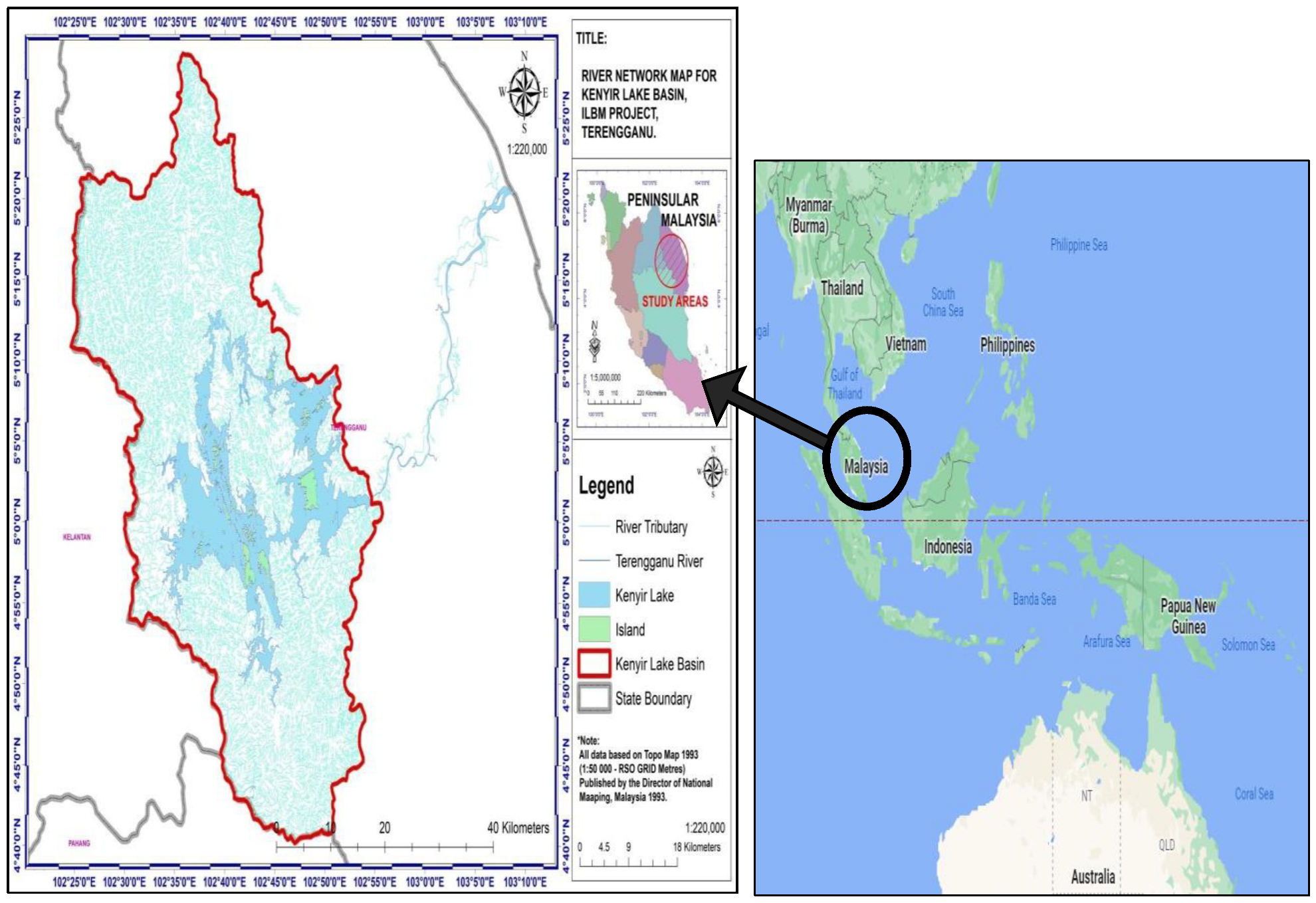
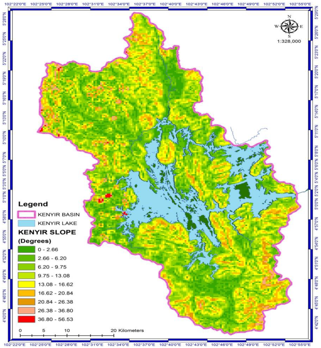
2.1. Study Area
2.1.1. Climatology Status
2.1.2. Land Use Distribution
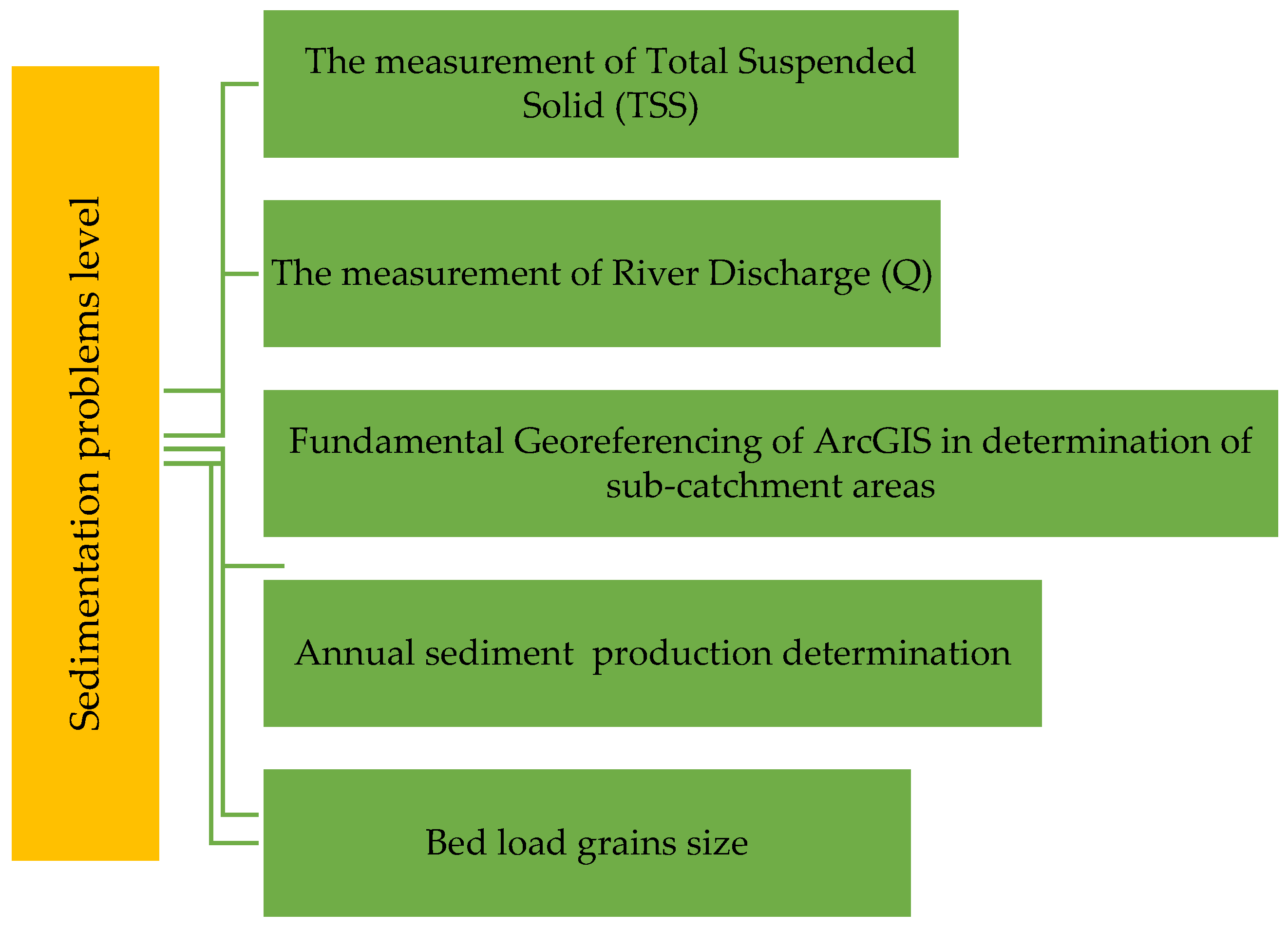
3. Research Methodology
3.1. The Measurement of Total Suspended Solid (TSS)
3.2. The Measurement of River Discharge (Q)
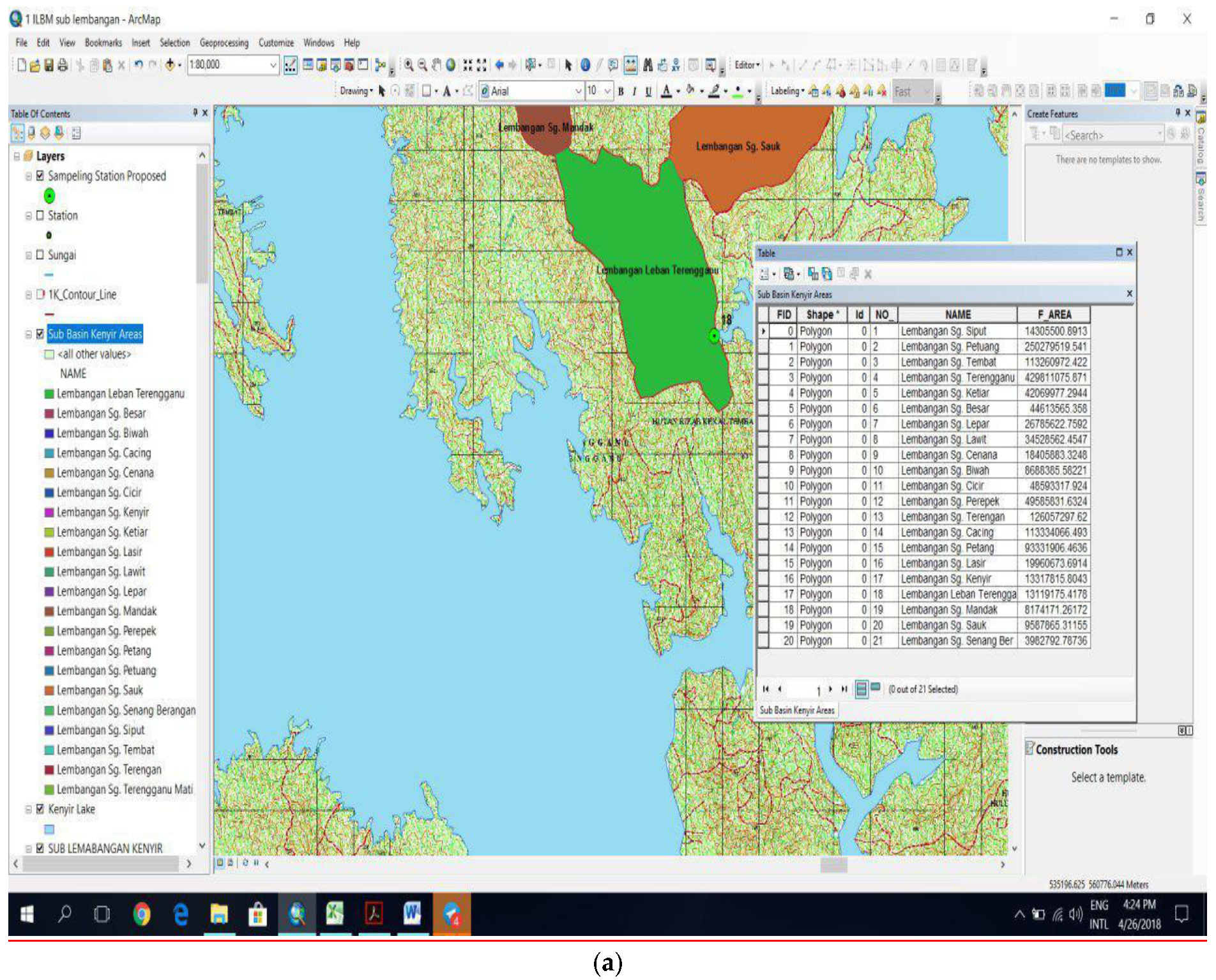
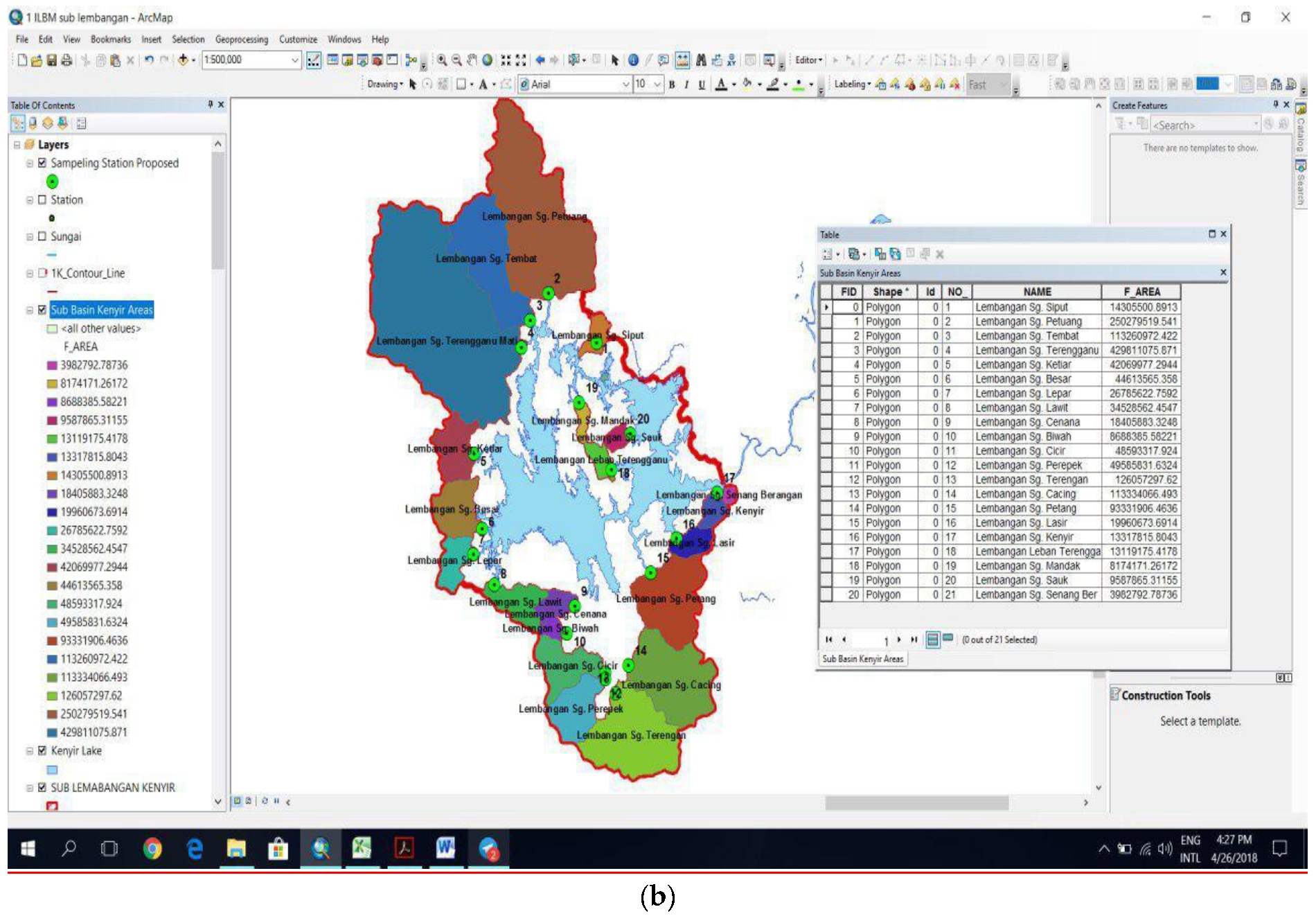
3.3. Fundamental Georeferencing of ArcGIS in the Determination of Catchment Areas
3.4. Annual Sediment Production Determination Areas
3.5. Size Measurement of Bed Load Grains
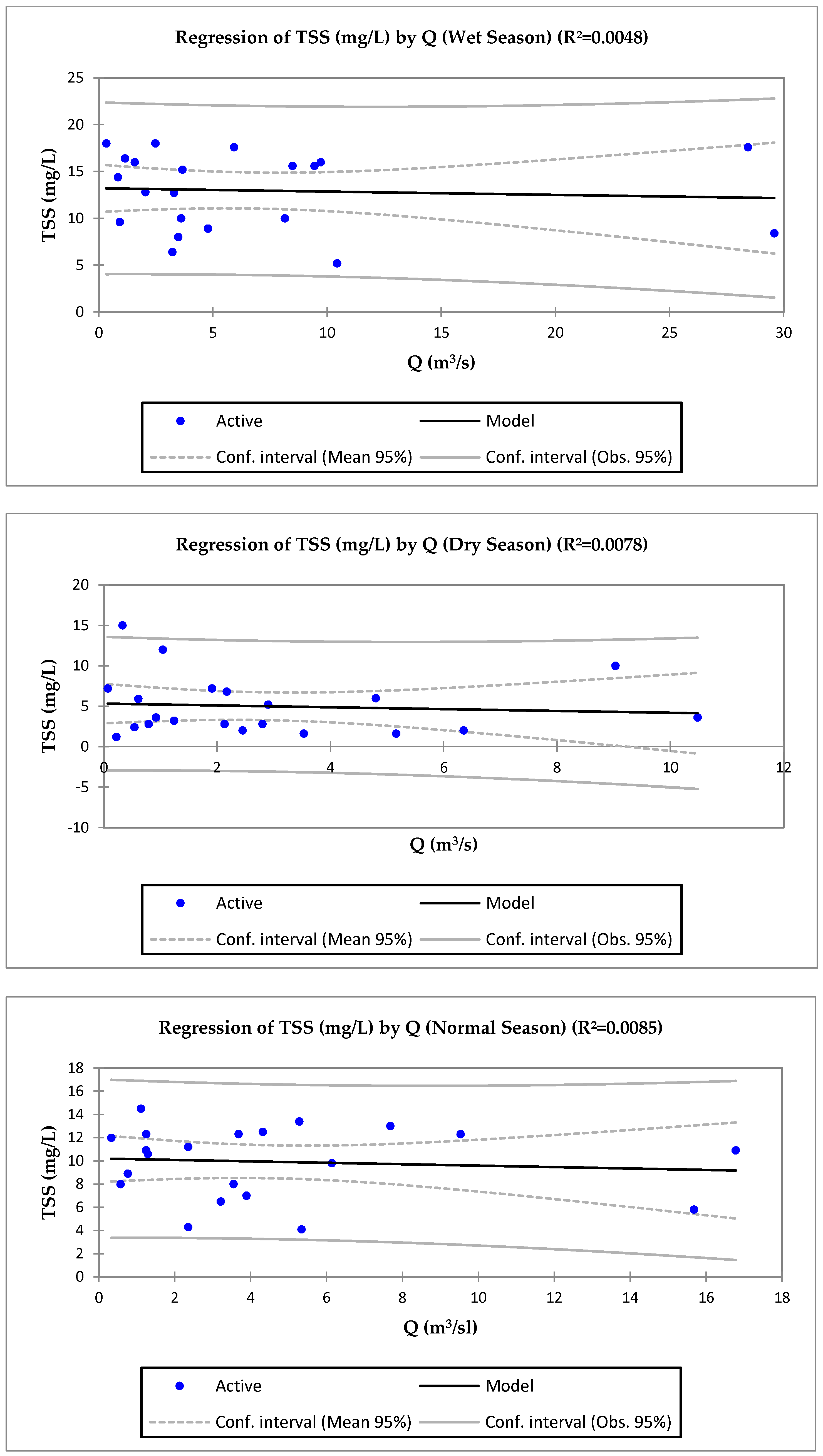
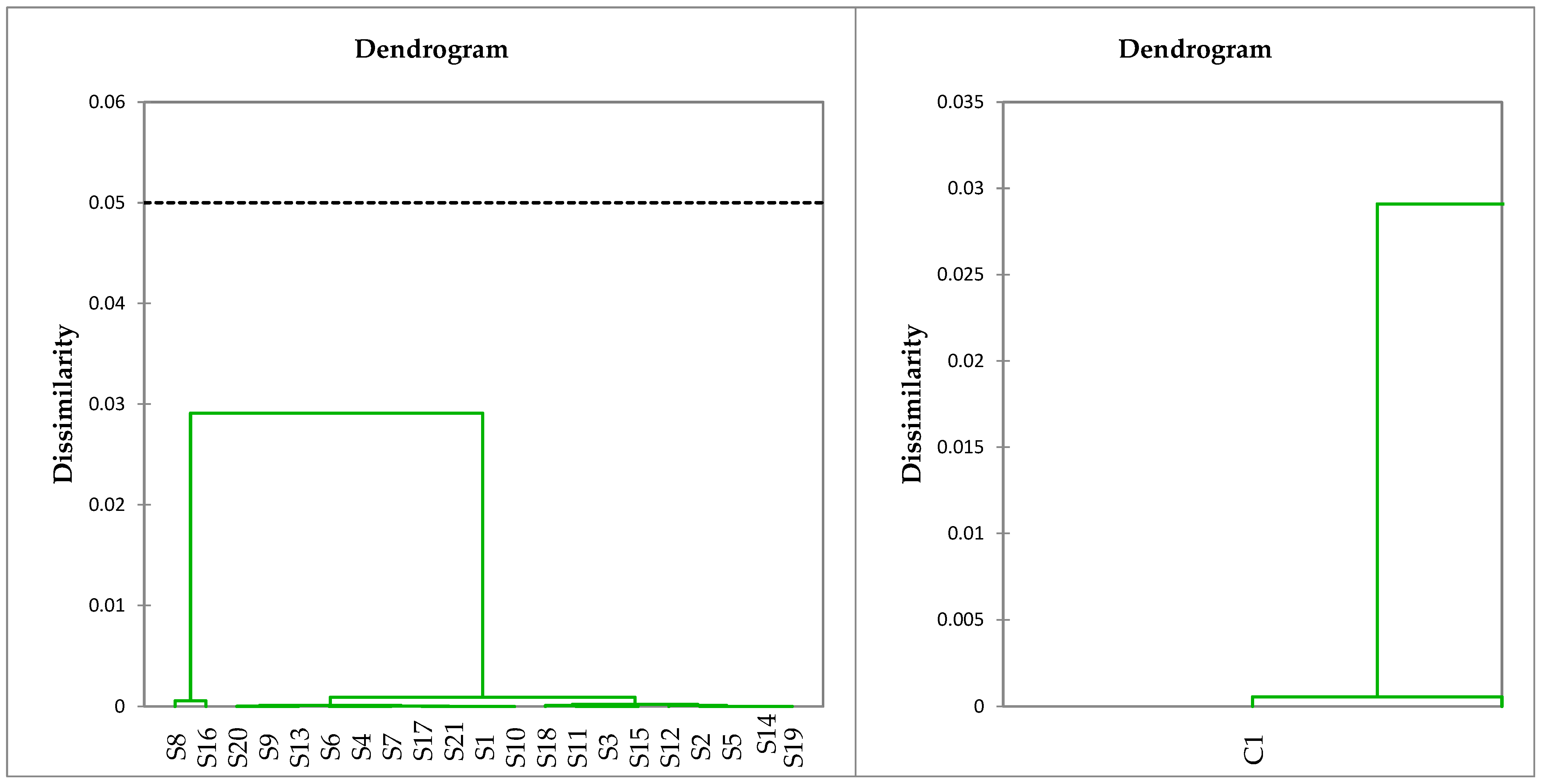
4. Results and Discussion
5. Conclusions
Author Contributions
Funding
Data Availability Statement
Acknowledgments
Conflicts of Interest
Appendix A

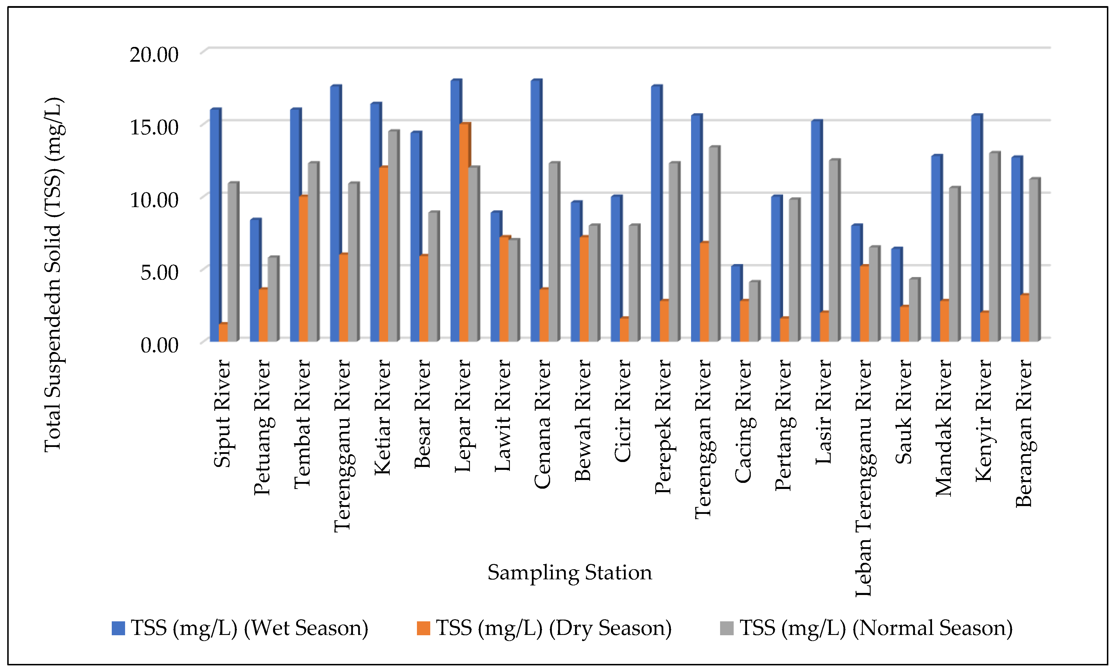
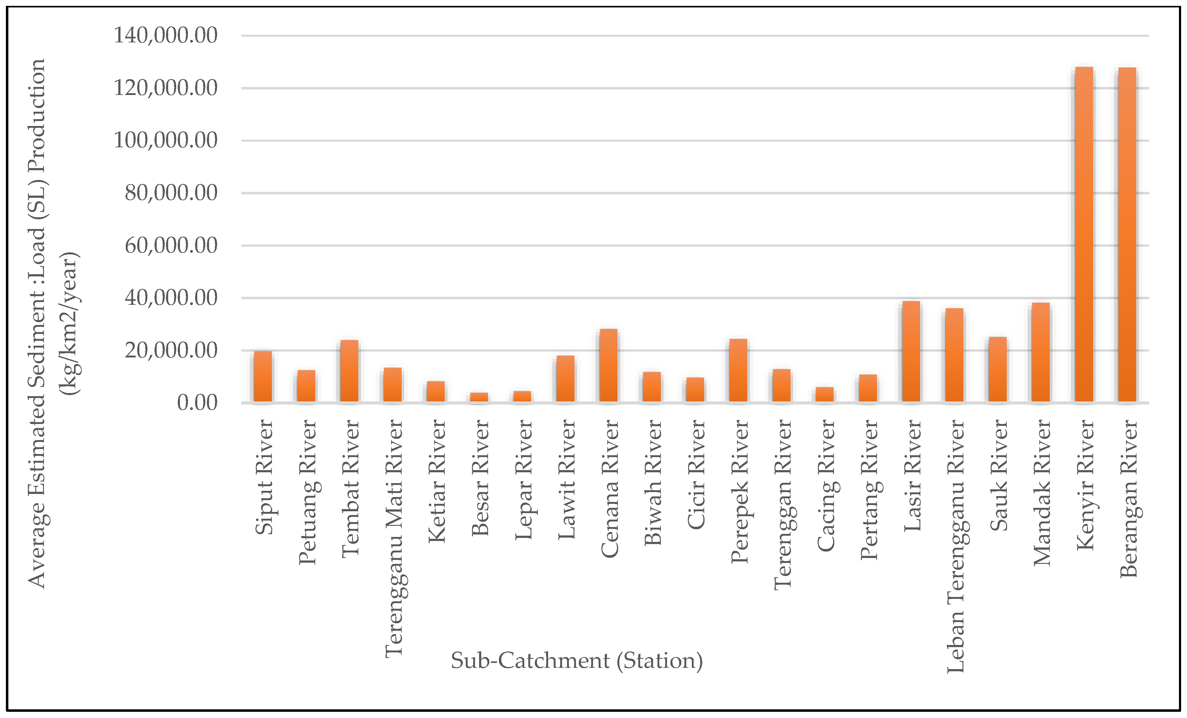
| Sampling Station | Sub-Catchment Area (km2) | Parameter | Wet Season (August 2018) | Dry Season (March 2019) | Normal Season (July 2019) | Average |
| Station 1 Sub-Catchment Siput River | 14.306 | TSS (mg/L) | 16.00 | 1.20 | 10.92 | 9.37 |
| Total Sediment (kg/km2/day) | 151.81 | 1.59 | 8.22 | 53.87 | ||
| Total Sediment (kg/km2/year) | 55,409.54 | 581.96 | 2999.36 | 19,663.62 | ||
| Total Sediment (tonnes/km2/day) | 0.15 | 0.0016 | 0.008 | 0.05 | ||
| Total Sediment (tonnes/km2/year) | 55.41 | 0.58 | 3.00 | 19.66 | ||
| Station 2 Sub-Catchment Petuang River | 250.28 | TSS (mg/L) | 8.40 | 3.60 | 5.8 | 5.93 |
| Total Sediment (kg/km2/day) | 85.80 | 13.02 | 3.14 | 33.99 | ||
| Total Sediment (kg/km2/year) | 31,318.77 | 4753.84 | 1145.92 | 12,406.18 | ||
| Total Sediment (tonnes/km2/day) | 0.09 | 0.01 | 0.003 | 0.03 | ||
| Total Sediment (tonnes/km2/year) | 31.32 | 4.75 | 1.15 | 12.41 | ||
| Station 3 Sub-Catchment Tembat River | 113.261 | TSS (mg/L) | 16.00 | 10.00 | 12.3 | 12.77 |
| Total Sediment (kg/km2/day) | 118.64 | 68.88 | 8.94 | 65.49 | ||
| Total Sediment (kg/km2/year) | 43,302.45 | 25,142.82 | 3263.81 | 23,903.02 | ||
| Total Sediment (tonnes/km2/day) | 0.12 | 0.07 | 0.009 | 0.07 | ||
| Total Sediment (tonnes/km2/year) | 43.30 | 25.14 | 3.26 | 23.90 | ||
| Station 4 Sub-Catchment Terengganu River | 429.811 | TSS (mg/L) | 17.60 | 6.00 | 10.9 | 11.50 |
| Total Sediment (kg/km2/day) | 100.60 | 5.79 | 3.68 | 36.69 | ||
| Total Sediment (kg/km2/year) | 36,720.64 | 2113.11 | 1341.98 | 13,391.91 | ||
| Total Sediment (tonnes/km2/day) | 0.10 | 0.01 | 0.004 | 0.04 | ||
| Total Sediment (tonnes/km2/year) | 36.72 | 2.11 | 1.34 | 13.39 | ||
| Station 5 Sub-Catchment Ketiar River | 42.07 | TSS (mg/L) | 16.40 | 12.00 | 14.5 | 14.30 |
| Total Sediment (kg/km2/day) | 38.56 | 25.63 | 3.31 | 22.50 | ||
| Total Sediment (kg/km2/year) | 14,076.14 | 9355.11 | 1206.49 | 8212.58 | ||
| Total Sediment (tonnes/km2/day) | 0.04 | 0.03 | 0.003 | 0.02 | ||
| Total Sediment (tonnes/km2/year) | 14.08 | 9.36 | 1.21 | 8.21 | ||
| Station 6 Sub-Catchment Besar River | 44.614 | TSS (mg/L) | 14.40 | 5.90 | 8.9 | 9.73 |
| Total Sediment (kg/km2/day) | 23.23 | 6.97 | 1.31 | 10.50 | ||
| Total Sediment (kg/km2/year) | 8478.97 | 2544.00 | 478.12 | 3833.70 | ||
| Total Sediment (tonnes/km2/day) | 0.02 | 0.01 | 0.001 | 0.01 | ||
| Total Sediment (tonnes/km2/year) | 8.48 | 2.54 | 0.48 | 3.83 | ||
| Station 7 Sub-Catchment Lepar River | 26.786 | TSS (mg/L) | 18.00 | 15.00 | 12 | 15.00 |
| Total Sediment (kg/km2/day) | 19.16 | 15.97 | 1.28 | 12.13 | ||
| Total Sediment (kg/km2/year) | 6993.35 | 5827.79 | 466.22 | 4429.12 | ||
| Total Sediment (tonnes/km2/day) | 0.02 | 0.02 | 0.001 | 0.01 | ||
| Total Sediment (tonnes/km2/year) | 6.99 | 5.83 | 0.47 | 4.43 | ||
| Station 8 Sub-Catchment Lawit River | 34.529 | TSS (mg/L) | 8.90 | 7.20 | 7 | 7.70 |
| Total Sediment (kg/km2/day) | 106.41 | 34.41 | 6.81 | 49.21 | ||
| Total Sediment (kg/km2/year) | 38,838.17 | 12,559.97 | 2486.97 | 17,961.70 | ||
| Total Sediment (tonnes/km2/day) | 0.11 | 0.03 | 0.007 | 0.05 | ||
| Total Sediment (tonnes/km2/year) | 38.84 | 12.56 | 2.49 | 17.96 | ||
| Station 9 Sub-Catchment Cenana River | 18.406 | TSS (mg/L) | 18.00 | 3.60 | 12.3 | 11.30 |
| Total Sediment (kg/km2/day) | 209.12 | 15.55 | 7.22 | 77.30 | ||
| Total Sediment (kg/km2/year) | 76,329.94 | 5674.63 | 2634.28 | 28,212.95 | ||
| Total Sediment (tonnes/km2/day) | 0.21 | 0.02 | 0.007 | 0.08 | ||
| Total Sediment (tonnes/km2/year) | 76.33 | 5.67 | 2.63 | 28.21 | ||
| Station 10 Sub-Catchment Bewah River | 8.688 | TSS (mg/L) | 9.60 | 7.20 | 8 | 8.27 |
| Total Sediment (kg/km2/day) | 87.55 | 5.01 | 4.53 | 32.36 | ||
| Total Sediment (kg/km2/year) | 31,954.16 | 1829.44 | 1655.20 | 11,812.93 | ||
| Total Sediment (tonnes/km2/day) | 0.09 | 0.01 | 0.005 | 0.03 | ||
| Total Sediment (tonnes/km2/year) | 31.95 | 1.83 | 1.66 | 11.81 | ||
| Station 11 Sub-Catchment Cicir River | 48.593 | TSS (mg/L) | 10.00 | 1.60 | 8 | 6.53 |
| Total Sediment (kg/km2/day) | 64.08 | 10.04 | 5.05 | 26.39 | ||
| Total Sediment (kg/km2/year) | 23,389.32 | 3665.45 | 1843.11 | 9632.63 | ||
| Total Sediment (tonnes/km2/day) | 0.06 | 0.01 | 0.005 | 0.03 | ||
| Total Sediment (tonnes/km2/year) | 23.39 | 3.67 | 1.84 | 9.63 | ||
| Station 12 Sub-Catchment Perepek River | 49.586 | TSS (mg/L) | 17.60 | 2.80 | 12.3 | 10.90 |
| Total Sediment (kg/km2/day) | 181.64 | 10.39 | 7.89 | 66.64 | ||
| Total Sediment (kg/km2/year) | 66,298.23 | 3793.02 | 2878.73 | 24,323.33 | ||
| Total Sediment (tonnes/km2/day) | 0.18 | 0.01 | 0.008 | 0.07 | ||
| Total Sediment (tonnes/km2/year) | 66.30 | 3.79 | 2.88 | 24.32 | ||
| Station 13 Sub-Catchment Terenggan River | 126.057 | TSS (mg/L) | 15.60 | 6.80 | 13.4 | 11.93 |
| Total Sediment (kg/km2/day) | 90.72 | 10.11 | 4.85 | 35.23 | ||
| Total Sediment (kg/km2/year) | 33,114.34 | 3691.55 | 1770.02 | 12,858.64 | ||
| Total Sediment (tonnes/km2/day) | 0.09 | 0.01 | 0.005 | 0.04 | ||
| Total Sediment (tonnes/km2/year) | 33.11 | 3.69 | 1.77 | 12.86 | ||
| Station 14 Sub-Catchment Cacing River | 113.334 | TSS (mg/L) | 5.20 | 2.80 | 4.1 | 4.03 |
| Total Sediment (kg/km2/day) | 41.37 | 5.98 | 1.67 | 16.34 | ||
| Total Sediment (kg/km2/year) | 15,100.24 | 2181.54 | 609.22 | 5963.66 | ||
| Total Sediment (tonnes/km2/day) | 0.04 | 0.01 | 0.002 | 0.02 | ||
| Total Sediment (tonnes/km2/year) | 15.10 | 2.18 | 0.61 | 5.96 | ||
| Station 15 Sub-Catchment Pertang River | 93.332 | TSS (mg/L) | 10.00 | 1.60 | 9.8 | 7.13 |
| Total Sediment (kg/km2/day) | 75.44 | 7.64 | 5.57 | 29.55 | ||
| Total Sediment (kg/km2/year) | 27,534.70 | 2789.62 | 2033.15 | 10,785.83 | ||
| Total Sediment (tonnes/km2/day) | 0.08 | 0.01 | 0.006 | 0.03 | ||
| Total Sediment (tonnes/km2/year) | 27.53 | 2.79 | 2.03 | 10.79 | ||
| Station 16 Sub-Catchment Lasir River | 19.961 | TSS (mg/L) | 15.20 | 2.00 | 12.5 | 9.90 |
| Total Sediment (kg/km2/day) | 240.80 | 54.97 | 23.37 | 106.38 | ||
| Total Sediment (kg/km2/year) | 87,891.93 | 20,064.49 | 8531.36 | 38,829.26 | ||
| Total Sediment (tonnes/km2/day) | 0.24 | 0.05 | 0.023 | 0.11 | ||
| Total Sediment (tonnes/km2/year) | 87.89 | 20.06 | 8.53 | 38.83 | ||
| Station 17 Sub-Catchment Leban Terengganu River | 13.119 | TSS (mg/L) | 8.00 | 5.20 | 6.5 | 6.57 |
| Total Sediment (kg/km2/day) | 183.25 | 99.31 | 13.74 | 98.77 | ||
| Total Sediment (kg/km2/year) | 66,884.49 | 36,249.93 | 5015.62 | 36,050.01 | ||
| Total Sediment (tonnes/km2/day) | 0.18 | 0.10 | 0.014 | 0.10 | ||
| Total Sediment (tonnes/km2/year) | 66.88 | 36.25 | 5.02 | 36.05 | ||
| Station 18 Sub-Catchment Sauk River | 9.588 | TSS (mg/L) | 6.40 | 2.40 | 4.3 | 4.37 |
| Total Sediment (kg/km2/day) | 185.82 | 11.68 | 9.11 | 68.87 | ||
| Total Sediment (kg/km2/year) | 67,824.11 | 4262.69 | 3323.65 | 25,136.81 | ||
| Total Sediment (tonnes/km2/day) | 0.19 | 0.01 | 0.009 | 0.07 | ||
| Total Sediment (tonnes/km2/year) | 67.82 | 4.26 | 3.32 | 25.14 | ||
| Station 19 Sub-Catchment Mandak River | 8.174 | TSS (mg/L) | 12.80 | 2.80 | 10.6 | 8.73 |
| Total Sediment (kg/km2/day) | 276.14 | 23.38 | 14.45 | 104.66 | ||
| Total Sediment (kg/km2/year) | 100,791.74 | 8534.09 | 5275.55 | 38,200.46 | ||
| Total Sediment (tonnes/km2/day) | 0.28 | 0.02 | 0.014 | 0.10 | ||
| Total Sediment (tonnes/km2/year) | 100.79 | 8.53 | 5.28 | 38.20 | ||
| Station 20 Sub-Catchment Kenyir River | 13.318 | TSS (mg/L) | 15.60 | 2 | 13 | 10.20 |
| Total Sediment (kg/km2/day) | 956.08 | 31.79 | 64.77 | 350.88 | ||
| Total Sediment (kg/km2/year) | 348,968.41 | 11,602.82 | 23,641.34 | 128,070.86 | ||
| Total Sediment (tonnes/km2/day) | 0.96 | 0.03 | 0.065 | 0.35 | ||
| Total Sediment (tonnes/km2/year) | 348.97 | 11.60 | 23.64 | 128.07 | ||
| Station 21 Sub-Catchment Berangan River | 3.983 | TSS (mg/L) | 12.70 | 3.2 | 11.2 | 9.03 |
| Total Sediment (kg/km2/day) | 907.19 | 86.07 | 57.09 | 350.12 | ||
| Total Sediment (kg/km2/year) | 331,124.83 | 31,417.24 | 20,839.25 | 127,793.77 | ||
| Total Sediment (tonnes/km2/day) | 0.91 | 0.09 | 0.057 | 0.35 | ||
| Total Sediment (tonnes/km2/year) | 331.12 | 31.42 | 20.84 | 127.79 |
References
- TNBR. Final Report of Pelan Pengurusan Pembangunan Bersepadu (ILBM) Lembangan Tasik Kenyir Dan Hulu Terengganu; TNB Research Sdn. Bhd.: Kajang, Malaysia, 2018. [Google Scholar]
- Farajzadeh, J.; Fard, A.F.; Lotfi, S. Modeling of Monthly Rainfall and Runoff of Urmia Lake Basin Using “Feed-Forward Neural Network” and “Time Series Analysis” Model. Water Resour. Ind. 2014, 7, 38–48. [Google Scholar] [CrossRef] [Green Version]
- Duan, W.; He, B.; Nover, D.; Yang, G.; Chen, W.; Meng, H.; Liu, C. Water Quality Assessment and Pollution Source Identification of the Eastern Poyang Lake Basin Using Multivariate Statistical Methods. Sustainability 2016, 8, 133. [Google Scholar] [CrossRef] [Green Version]
- Sharip, Z.; Zakaria, S.; Md Noh, M.N.; Nakamura, M.; Muhandiki, V. A Review of the Importance, Gaps and Future Directions of Integrated Lake Basin Management Planning in Malaysia. Lakes Reserv. Res. Manag. 2021, 26, e12355. [Google Scholar] [CrossRef]
- Sharip, Z.; Zakaria, S. Lakes and Reservoir in Malaysia: Management and Research Challenges. In Proceedings of the Taal 2007: The 12th World Lake Conference, Jaipur, India, 28 October–2 November 2007. [Google Scholar]
- Sharip, Z.; Jusoh, J. Integrated Lake Basin Management and Its Importance for Lake Chini and Other Lakes in Malaysia. Lakes Reserv. Res. Manag. 2010, 15, 41–51. [Google Scholar] [CrossRef]
- Tung, T.M.; Yaseen, Z.M. A Survey On River Water Quality Modelling Using Artificial Intelligence Models: 2000–2020. J. Hydrol. 2020, 585, 124670. [Google Scholar]
- Denaro, S.; Anghileri, D.; Giuliani, M.; Castelletti, A. Informing the Operations of Water Reservoirs Over Multiple Temporal Scales by Direct Use of Hydro-Meteorological Data. Adv. Water Resour. 2017, 103, 51–63. [Google Scholar] [CrossRef] [Green Version]
- Hossain, M.; Huda, A.S.N.; Mekhilef, S.; Seyedmahmoudian, M.; Horan, B.; Stojcevski, A.; Ahmed, M. A State-of-the-Art Review of Hydropower in Malaysia as Renewable Energy: Current Status and Future Prospects. Energy Strategy Rev. 2018, 22, 426–437. [Google Scholar] [CrossRef]
- Sim, L.M.; Onishi, A.; Gervais, O.; Chan, N.W. Comparative Research on River Basin Management in the Sagami River Basin (Japan) and the Muda River Basin (Malaysia). Resources 2018, 7, 33. [Google Scholar] [CrossRef] [Green Version]
- Wahab, N.A.; Kamarudin, M.K.A.; Toriman, M.E.; Juahir, H.; Saad, M.H.M.; Ata, F.M.; Ghazali, A.; Hassan, A.R.; Abdullah, H.; Maulud, K.N.; et al. Sedimentation and Water Quality Deterioration Problems at Terengganu River basin, Terengganu, Malaysia. Desalination Water Treat. 2019, 149, 228–241. [Google Scholar] [CrossRef] [Green Version]
- Maliki, A.A.; Chabuk, A.; Sultan, M.A.; Hashim, B.M.; Hussain, H.M.; Al-Ansari, N. Estimation of Total Dissolved Solids in Water Bodies by Spectral Indices Case Study: Shatt al-Arab River. Water Air Soil Pollut. 2020, 231, 482. [Google Scholar] [CrossRef]
- Sharip, Z.; Majizat, A.; Suratman, S. Socio-economic and Institutional Assessment of Malaysia’s First Biosphere Reserve: Chini Lake. Lakes Reserv. Res. Manag. 2018, 23, 104–116. [Google Scholar] [CrossRef]
- Islam, S.; Elfithri, R. The Potential Impacts of Anthropogenic and Climate Changes Factors on Surface Water Ecosystem Deterioration at Kenyir Lake, Malaysia. Int. J. Eng. Technol. 2018, 7, 67–74. [Google Scholar]
- Guidelines for Integrated Lake Basin Management (ILBM) Plan; National Hydraulic Research Institute of Malaysia (NAHRIM): Putrajaya, Malaysia, 2018.
- Bakar, A.F.A. Erosion and Sedimentation at Putrajaya Wetland. Ph.D. Thesis, University Malaya, Kuala Lumpur, Malaysia, 2009. [Google Scholar]
- Bhattarai, R.; Dutta, D. Estimation of Soil Erosion and Sediment Yield Using GIS at Catchment Scale. Water Resour. Manag. 2007, 21, 1635–1647. [Google Scholar] [CrossRef]
- Toriman, M.E.; Ata, F.M.; Kamarudin, M.K.A.; Idris, M. Bed-Load Sediment Profile and Effect of River Bank Erosion on River Cross-Section. Am. J. Environ. Sci. 2013, 9, 292–300. [Google Scholar] [CrossRef] [Green Version]
- Amran, N.H.M.; Kamarudin, M.K.A.; Wahab, N.A.; Saad, M.H.M.; Rolis, M.H.; Samah, M.A.A.; Baharim, N.B.; Razak, N.A.E.M.; Jusoh, S. Environmental Management on Natural River Based on Water Quality Deterioration in Terengganu River Basin, Terengganu, Malaysia. Int. J. Eng. Technol. 2018, 7, 28–32. [Google Scholar]
- Razak, N.A.E.M.; Kamarudin, M.K.A.; Wahab, N.A.; Saudi, A.S.M.; Saad, M.H.M.; Ata, F.M.; Amran, N.H.M. Water Resources Management of Sedimentation Problems in Terengganu River Basin, Terengganu, Malaysia. Int. J. Eng. Technol. 2018, 7, 4–20. [Google Scholar]
- Toriman, M.E.; Hassan, A.J.; Gasim, M.B.; Mokhtar, M.; Sharifah Mastura, S.A.; Jaafar, O.; Aziz, N.A.A. Integration of 1-D Hydrodynamic Model and GIS Approach in Flood Management Study in Malaysia. J. Earth Sci. Res. 2009, 1, 22–27. [Google Scholar]
- Toriman, M.E.; Mokhtar, M.; Karim, O.; Gasim, M.B.; Taha, R. Short-Term Sediment Yields From Small Catchment of Sungai Anak Bangi Selangor. Bull. Geol. Soc. 2009, 55, 55–59. [Google Scholar] [CrossRef] [Green Version]
- Toriman, M.E.; Jaafar, O.; Maru, R.; Arfan, A.; Ahmar, A.S. Daily Suspended Sediment Discharge Prediction Using Multiple Linear Regression and Artificial Neural Network. J. Phys. Conf. Ser. 2018, 954, 012030. [Google Scholar]
- Shah, M.R.M.; Sidek, L.M.; Yalit, M.R.; Marufuzzaman, M.; Basri, H.; Yaacob, M.K. 2D hydraulic modelling of dam break analysis using MIKE FLOOD for Kenyir Dam. In ICDSME 2019, Proceedings of the 1st International Conference on Dam Safety Management and Engineering, Penang, Malaysia, 18–22 December 2019; Springer Nature: Berlin/Heidelberg, Germany, 2019; p. 214. [Google Scholar]
- Abdullah, S.M.; Al-Toum, S.; Jaafar, O. Rainsplash Erosion: A Case Study in Telaka River Catchment, East Selangor, Malaysia. Geografia 2003, 1, 44–59. [Google Scholar]
- Gobin, A.; Jones, R.; Kirkby, M.; Campling, P.; Govers, G.; Kosmas, C.; Gentile, A.R. Indicators for Pan-European Assessment and Monitoring of Soil Erosion by Water. Environ. Sci. Policy 2004, 7, 25–38. [Google Scholar] [CrossRef]
- Sufiyan, I.; Ji, M.; Ogah, A.T. Hydrologic Assessment of Food Using SWAT as Geospatial Techniques in the Catchment Area of Terengganu Malaysia. Malays. J. Geosci. 2020, 4, 90–95. [Google Scholar] [CrossRef]
- Smakhtin, V.; Weragala, N. An Assessment of Hydrology and Environmental Flows in the Walawe River Basin, Sri Lanka; Working Paper 103; International Water Management Institute (IWMI): Colombo, Sri Lanka, 2005. [Google Scholar]
- Toriman, M.E.; Kamarudin, M.K.A.; Aziz, N.A.A.; Gasim, M.B.; Idris, M.H.; Jamil, N.R. Modeling the Hydrologic-Hydraulic of Backwater Flow and Sediment Particle Saiz Analysis in Sungai Chini, Pahang. e-Bangi 2009, 4, 56–69. [Google Scholar]
- Gasim, M.B.; Toriman, M.E.; Idris, M.; Lun, P.I.; Kamarudin, M.K.A.; Azlina, A.N.; Sharifah Mastura, S.A. River Flow Conditions and Dynamic State Analysis of Pahang River. Am. J. Appl. Sci. 2013, 10, 42–57. [Google Scholar]
- Chow, M.F.; Subbramaniam, P.; Sidek, L.M. Assessment of Sedimentation Problem in Kenyir Hydropower Reservoir. IOP Conf. Ser. Earth Environ. Sci. 2020, 541, 012008. [Google Scholar] [CrossRef]
- Kamarudin, M.K.A.; Gidado, K.A.; Toriman, M.E.; Juahir, H.; Umar, R.; Wahab, N.A.; Maulud, K.N.A. Classification of Land Use/Land Cover Changes Using GIS and Remote Sensing Technique in Lake Kenyir Basin, Terengganu, Malaysia. Int. J. Eng. Technol. 2018, 7, 12–15. [Google Scholar] [CrossRef]
- Sumi, T.; Okano, M.; Takata, Y. Reservoir Sedimentation Management with Bypass Tunnels in Japan. In Proceedings of the 9th International Symposium on River Sedimentation, Yichang, China, 18–21 October 2004. [Google Scholar]
- Hanif, N.M.; Latif, M.T.; Othman, M.R. Atmospheric Surfactants Around Lake Ecosystem of Tasik Kenyir, Terengganu. Malays. J. Anal. Sci. 2011, 15, 1–7. [Google Scholar]
- Bhuiyan, M.A.H.; Siwar, C.; Ismail, S.M. Sustainability Measurement for Ecotourism Destination in Malaysia: A Study on Lake Kenyir, Terengganu. Soc. Indic. Res. 2016, 128, 1029–1045. [Google Scholar] [CrossRef]
- Sufiyan, I.; Magaji, J.I. Modeling Flood Hazard using SWAT and 3D Analysis in Terengannu Watershed. J. Clean WAS 2018, 2, 19–24. [Google Scholar] [CrossRef]
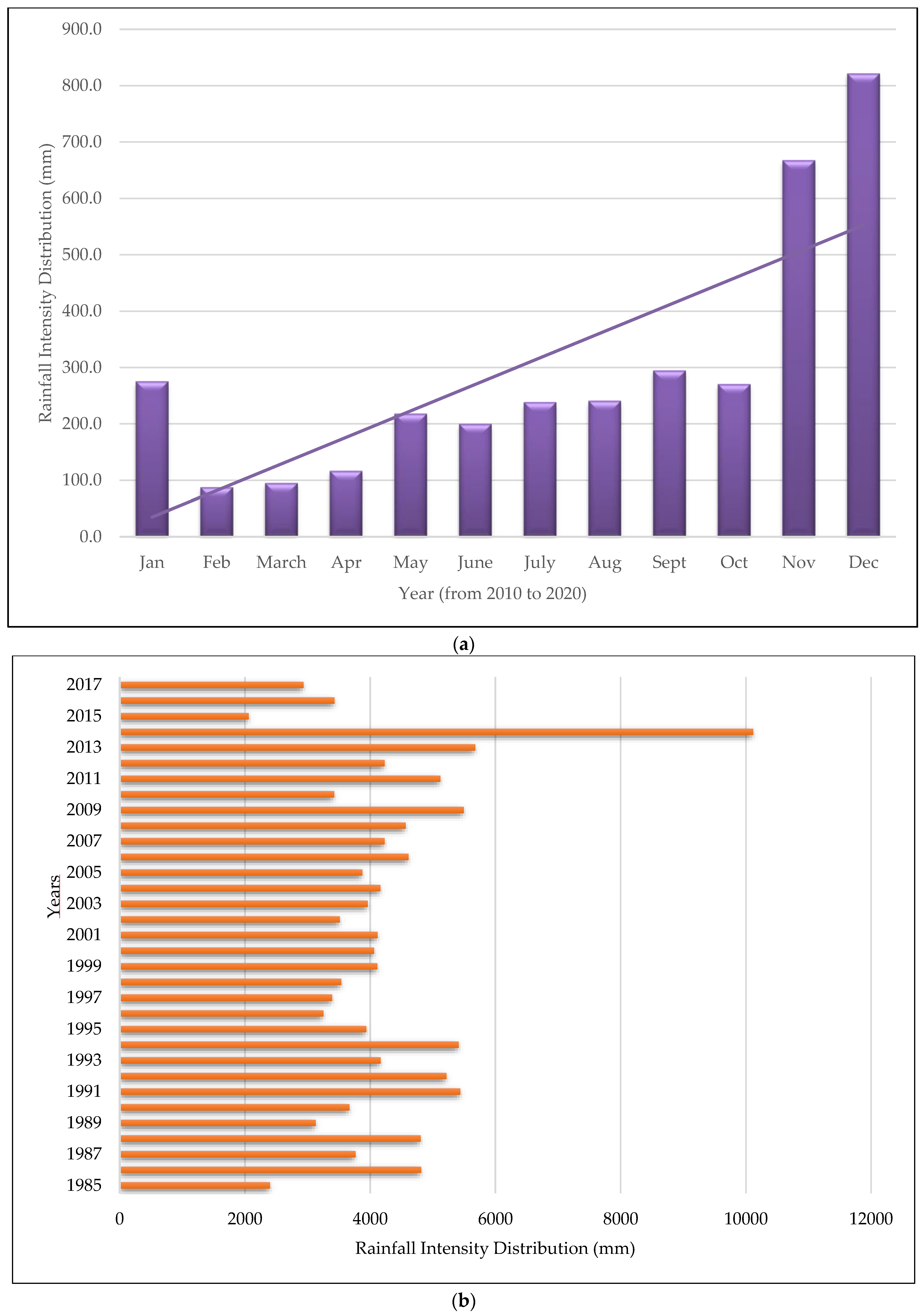
- The Distribution of Rainfall Intensity and Humidity Level at Kuala Terengganu Station and Felda Belara Station; Jabatan Meteorologi Malaysia, Malaysian Meteorological Department (MMD): Petaling Jaya, Malaysia, 2021.
- Wagner, T.; Themeßl, M.; Schüppel, A.; Gobiet, A.; Stigler, H.; Birk, S. Impacts of Climate Change on Stream Flow and Hydro Power Generation in the Alpine region. Environ. Earth Sci. 2017, 76, 4. [Google Scholar] [CrossRef] [Green Version]
- Wahab, N.A.; Kamarudin, M.K.A.; Toriman, M.E.; Juahir, H.; Gasim, M.B.; Rizman, Z.I.; Damayanti, P.P. Climate Changes Impacts Towards Sedimentation Rate at Terengganu River, Terengganu, Malaysia. J. Fundam. Appl Sci. 2018, 10, 33–51. [Google Scholar]
- Department of Drainage and Irrigation. Flood Archive; Ministry of Natural Resource and Environment: Kuala Lampur, Malaysia, 2014.
- Report of Rancangan Kawasan Khas (RKK): Kawasan Dataran Banjir, Tanah Lembab, Bekas Lombong, Tasik dan Sungai. Garis Panduan Perancangan Pemuliharaan dan Pembangunan, Kawasan Sensitif Alam Sekitar (KSAS); Town and Country Planning Department, Ministry of Local Government Development: Putrajaya, Malaysia, 2010.
- Gidado, K.A.; Kamarudin, M.K.A.; Firdaus, N.A.; Nalado, A.M.; Saudi, A.S.M.; Saad, M.H.M.; Ibrahim, S. Analysis of Spatiotemporal Land Use and Land Cover Changes using Remote Sensing and GIS: A Review. Int. J. Eng. Technol. 2018, 7, 56–60. [Google Scholar]
- Prodger, S.; Russell, P.; Davidson, M.; Miles, J.; Scott, T. Understanding and Predicting the Temporal Variability of Sediment Grain Size Characteristics on High-Energy Beaches. Mar. Geol. 2016, 376, 109–117. [Google Scholar] [CrossRef] [Green Version]
- Wahab, N.A.; Kamarudin, M.K.A.; Gasim, M.B.; Umar, R.; Ata, F.M.; Sulaiman, N.H. Assessment of Total Suspended Sediment and Bed Sediment Grains in Upstream Areas of Lata Berangin, Terengganu. Int. J. Adv. Sci. Technol. 2016, 6, 757–763. [Google Scholar] [CrossRef] [Green Version]
- Wahab, N.A.; Kamarudin, M.K.A.; Mustaffa, N.I.H.; Saad, M.H.M.; Bati, S.N.A.M.; Ata, F.M. Impact of Wastewater on Surface Water Quality in Kenyir Lake Basin, Hulu Terengganu. J. Waste. Biomass Manag. 2022, 4, 50–54. [Google Scholar]
- Toriman, M.E.; Er, A.C.; Mazlin, M.; Rahmah, E.; Muhammad, B.G.; Othman, K.; Jamil, N.R. River Regulation and Its Impact on River Channel Planform Changes. J. Eng. Appl. Sci. 2011, 6, 423–427. [Google Scholar]
- Abidin, M.H.Z.; Madun, A.; Tajudin, S.A.A.; Ishak, M.F. Forensic assessment on near surface landslide using electrical resistivity imaging (ERI) at Kenyir Lake Area in Terengganu, Malaysia. Procedia Eng. 2017, 171, 434–444. [Google Scholar] [CrossRef] [Green Version]
- Fathabadi, A.; Seyedian, S.M.; Malekian, A. Comparison of Bayesian, k-Nearest Neighbor and Gaussian process regression methods for quantifying uncertainty of suspended sediment concentration prediction. Sci. Total Environ. 2022, 818, 151760. [Google Scholar] [CrossRef]
- Nemerow, N.L. Stream, Lake, Estuary, and Ocean Pollution, 2nd ed.; Van Nostrand Reinhold: New York, NY, USA, 1991; pp. 1–472. [Google Scholar]
- Rozemeijer, J.; Noordhuis, R.; Ouwerkerk, K.; Pires, M.D.; Blauw, A.; Hooijboer, A.; Van Oldenborgh, G.J. Climate Variability Effects on Eutrophication of Groundwater, Lakes, Rivers, and Coastal Waters in the Netherlands. Sci. Total Environ. 2021, 771, 145366. [Google Scholar] [CrossRef]
- Sufiyan, I.; Zakariya, R.; Yaacob, R. Delineation of Flood Risk Zones and 3D Modeling in Terengganu River Catchment using GIS and SWAT. Environ. Ecosyst. Sci. 2018, 2, 1–5. [Google Scholar] [CrossRef]
- Ghurah, M.H.A.; Kamarudin, M.K.A.; Wahab, N.A.; Juahir, H.; Gasim, M.B.; Lananan, F.; Maulud, K.N.A.; Rosli, M.H.; Saudi, A.S.M.; Rizman, Z.I.; et al. Assesment of Urban Growth and Sprawl Using GIS and Remote Sensing Technique in South Ghor Region, Al-Karak, Jordan. Int. J. Eng. Technol. 2018, 7, 5–11. [Google Scholar] [CrossRef]
- Toriman, M.E.; Kamarudin, M.K.A.; Idris, M.H.; Gasim, M.B.; Jamil, N.R. Sedimentation Issue and Its Solution Through Environmental Management Approach: A Case Study in Sungai Chini, Pahang. e-Bangi 2008, 3, 1–14. [Google Scholar]
- Wisha, U.J.; Heriati, A. Analysis of Tidal Range and Its Effect on Distribution of Total Suspended Solid (TSS) in the Pare Bay Waters. Indones. J. Sci. Technol. 2016, 9, 23–31. [Google Scholar]
- Wahab, N.A.; Kamarudin, M.K.A.; Anuar, A.; Ata, F.M.; Sulaiman, N.H.; Baharim, N.B.; Harun, N.S.; Muhammad, N.A. Assessments of Lake Profiling on Temperature, Total Suspended Solid (TSS) and Turbidity in the Kenyir Lake, Terengganu, Malays. J. Fundam. Appl. Sci. 2017, 9, 256–278. [Google Scholar] [CrossRef] [Green Version]
- Wahab, N.A.; Kamarudin, M.K.A.; Toriman, M.E.; Ata, F.M.; Juahir, H.; Ghazali, A.; Anuar, A. The Evaluation of Dissolved Oxygen (DO), Total Suspended Solid (TSS) and Suspended Sediment Concentration (SSC) in Terengganu River, Malaysia. Int. J. Eng. Technol. 2018, 7, 44–48. [Google Scholar] [CrossRef]
- Kannel, P.R.; Lee, S.; Lee, Y.S.; Kanel, S.R.; Khan, S.P. Application of Water Quality Indices And Dissolved Oxygen As Indicators for River Water Classification and Urban Impact. Assessment. Environ. Monit. Assess. 2007, 132, 93–110. [Google Scholar] [CrossRef]
- Rashid, Z.A.; Amal, M.N.A.; Shohaimi, S. Water Quality Influences on Fish Occurrences in Sungai Pahang, Maran District, Pahang, Malaysia. Sains Malays. 2018, 47, 1941–1951. [Google Scholar] [CrossRef]
- Hasab, H.A.; Jawad, H.A.; Dibs, H.; Hussain, H.M.; Al-Ansari, N. Evaluation of Water Quality Parameters in Marshes Zone Southern of Iraq Based on Remote Sensing and GIS Techniques. Water Air Soil Pollut. 2020, 231, 183. [Google Scholar] [CrossRef] [Green Version]
- Kesel, R.H. Human Modifications to the Sediment Regime of the Lower Mississippi River Flood Plain. Geomorphology 2003, 56, 325–334. [Google Scholar] [CrossRef]
- Jha, M.; Pan, Z.; Takle, E.S.; Gu, R. Impacts of Climate Change on Streamflow in the Upper Mississippi River Basin: A Regional Climate Model Perspective. J. Geophys. Res. Atmos. 2004, 109, 1–12. [Google Scholar] [CrossRef]
- Mokhtar, M.B.; Toriman, M.E.H.; Hossain, M.A.A.; Tan, K.W. Institutional Challenges for Integrated River Basin Management in Langat River Basin, Malaysia. Water Environ. J. 2011, 25, 495–503. [Google Scholar] [CrossRef]
- Munoz, S.E.; Giosan, L.; Therrell, M.D.; Remo, J.W.; Shen, Z.; Sullivan, R.M.; Donnelly, J.P. Climatic Control of Mississippi River Flood Hazard Amplified by River Engineering. Nature 2018, 556, 95–98. [Google Scholar] [CrossRef]
- Hassan, M.A.A.; Kamarudin, M.K.A.; Samah, M.A.A.; Toriman, M.E.; Gasim, M.B.; Hanafiah, M.M.; Alubyad, L.O.M.; Saudi, A.S.M.; Maulud, K.N.; Wahab, N.A.; et al. Spatial and Temporal Variations of River Water Quality Using Multivariate Statistical Techniques. Desalin. Water Treat. 2022, 269, 106–122. [Google Scholar]
- Bati, S.N.A.M.; Kamarudin, M.K.A.; Toriman, M.E.; Samah, M.A.A.; Loh, I.H.; Hamzah, F.M.; Saad, M.H.M.; Wahab, N.A.; Mustaffa, N.I.H. Assessment of Water Quality Index in Lake Ecosystem. Desalin. Water Treat. 2022, 269, 123–131. [Google Scholar] [CrossRef]
- Zhang, H.; Jiang, Y.; Ding, M.; Xie, Z. Level, Source Identification, and Risk Analysis of Heavy Metal in Surface Sediments from River-Lake Ecosystems in the Poyang Lake, China. Environ. Sci. Pollut. Res. 2017, 24, 21902–21916. [Google Scholar] [CrossRef]
- Dlamini, N.S.; Kamal, M.R.; Soom, M.A.B.M.; Mohd, M.S.F.B.; Abdullah, A.F.B.; Hin, L.S. Modeling Potential Impacts of Climate Change on Streamflow Using Projections of the 5th Assessment Report for the Bernam River Basin, Malaysia. Water 2017, 9, 226. [Google Scholar] [CrossRef] [Green Version]
- Azid, A.; Che Hasnam, C.N.; Juahir, H.; Amran, M.A.; Toriman, M.E.; Kamarudin, M.K.A.; Saudi, A.S.M.; Gasim, M.B.; Mustafa, A.D. Coastal Erosion Measurement along Tanjung Lumpur to Cherok Paloh, Pahang during the Northeast Monsoon Season. J. Teknol. 2015, 74, 27–34. [Google Scholar] [CrossRef] [Green Version]
- Azaman, F.; Juahir, H.; Yunus, K.; Azid, A.; Kamarudin, M.K.A.; Toriman, M.E.; Mustafa, A.D.; Amran, M.A.; Hasnama, C.N.C.; Saudi, A.S.M. Heavy Metal in Fish: Analysis and Human Health-A Review. J. Teknol. 2015, 77, 61–69. [Google Scholar] [CrossRef] [Green Version]
- Liu, Y.; Long, H.; Li, T.; Tu, S. Land Use Transitions and Their Effects on Water Environment in Huang-Huai-Hai Plain, China. Land Use Policy 2015, 47, 293–301. [Google Scholar] [CrossRef]
- He, K.; Duan, C.Q.; Yang, S.M.; Ji, K.Q. Advances in Hydrological and Water Resources Response to Land Use/Cover Change. J. Water Resour. Res. 2015, 4, 240–248. [Google Scholar] [CrossRef]


| (a) | |||||||
| Elements | Specification Catchment Condition | ||||||
| Return period ARI | 2 | 5 | 10 | 50 | 100 | ||
| Catchment rainfall | 411 | 582 | 712 | 975 | 1087 | ||
| Peak flow (m3/s) | 3718 | 5277 | 6466 | 8880 | 9899 | ||
| Total flow | 1236 | 1679 | 2018 | 2706 | 2997 | ||
| Total sediment load production | tonnes/year | 693,238 | 853,227 | 998,355 | 1,437,772 | 1,682,334 | |
| m3/year | 450,155 | 554,043 | 648,283 | 933,618 | 1,092,425 | ||
| Year required to be fully deposited | Gross storage (m3) | 30,212 | 24,547 | 20,978 | 14,567 | 12,449 | |
| Live storage (m3) | 16,439 | 13,356 | 11,415 | 7926 | 6774 | ||
| Dead storage (m3) | 13,773 | 11,190 | 9564 | 6641 | 5675 | ||
| (b) | |||||||
| Elements | Present | Future 100-Year ARI | |||||
| Percentage reduction in forest from existing coverage | 10% | 25% | 50% | ||||
| Peak flow (m3/s) | 9899 | 10,011 | 10,132 | 50% | |||
| Total flow | 2997 | 3001 | 3007 | 10,267 | |||
| Peak water elevation (m) | 149.94 | 149.9 7 | 150.01 | 3018 | |||
| Total sediment load production | tonnes/year | 1,682,334 | 1,850,568 | 2,102,918 | 150.05 | ||
| m3/year | 1,092,425 | 1,201,667 | 1,365,531 | 2,523,501 | |||
| Year required to be fully deposited | Gross storage (m3) | 12,449 | 11,318 | 9959 | 1,638,637 | ||
| Live storage (m3) | 6774 | 6158 | 5419 | 8300 | |||
| Dead storage (m3) | 5675 | 5159 | 4540 | 4516 | |||
| (c) | |||||||
| Dam | Tunnel Completion (Year) | Cross-Section of Tunnel (B × H) (m) | Tunnel Length (m) | Design Discharge (m/s) | |||
| Nunobiki (Japan) | 1908 | 2.9 × 2.9 | 258 | 39 | |||
| Asahi (Japan) | 1998 | 3.8 × 3.8 | 2350 | 140 | |||
| Miwa (Japan) | 2004 | 2r = 7.8 | 4300 | 300 | |||
| Matsukawa (Japan) | 2016 | 5.2 × 5.2 | 1417 | 200 | |||
| Egshi (Switzerland) | 1976 | r = 2.8 | 360 | 74 | |||
| Palagnedra (Switzerland) | 1974 | 2r = 6.2 | 1800 | 110 | |||
| Pfaffensprung (Switzerland) | 1922 | A = 21 m2 | 280 | 220 | |||
| Rempen (Switzerland) | 1983 | 3.5 × 3.3 | 450 | 80 | |||
| Runcahez (Switzerland) | 1961 | 3.8 × 4.5 | 572 | 110 | |||
| Specification | Unit | Value |
|---|---|---|
| Length of Dam | [m] | 800 |
| Height of Dam | [m] | 150 |
| Spillway Length | [m] | 140 |
| Dam Crest Elevation | [mRL] | +155 |
| Maximum Flood Level | [mRL] | +153 |
| Full Supply Level | [mRL] | +145 |
| Minimum Operating Level | [mRL] | +120 |
| Lake Area | [km2] | 369 |
| Catchment Area | [km2] | 2612 |
| Gross Storage | [m3] | 13.6 × 10⁹ |
| Live Storage | [m3] | 7.4 × 10⁹ |
| Name of Power Station | - | Sultan Mahmud |
| Installed Capacity | MW | 4 × 100 |
| Average Annual Energy Output | GWh | 1600 |
| Station | Location | River Name | Area of Sub-Catchment (km2) | Datum Elevation M.S.L (m) | |
|---|---|---|---|---|---|
| Longitude | Latitude | ||||
| Station 1 (S1) | 102° 42′42.602″ E | 5°11′01.064″ N | Siput River | 14.306 | 151.26 m |
| Station 2 (S2) | 102°39′49.705″ E | 5°17′42.360″ N | Petuang River | 250.280 | 155.7 m |
| Station 3 (S3) | 102°38′19.879″ E | 5°12′57.393″ N | Tembat River | 113.261 | 153.62 m |
| Station 4 (S4) | 102°37′46.486″ E | 5°11′24.258″ N | Terengganu Mati River | 429.811 | 154.02 m |
| Station 5 (S5) | 102°33′17.735″ E | 5°03′30.462″ N | Ketiar River | 42.070 | 153.25 m |
| Station 6 (S6) | 102°34′15.044″ E | 4°58′03.613″ N | Besar River | 44.614 | 152.02 m |
| Station 7 (S7) | 102°33′09.379″ E | 4°56′16.506″ N | Lepar River | 26.786 | 149.9 m |
| Station 8 (S8) | 102°35′13.374″ E | 4°54′38.067″ N | Lawit River | 34.529 | 150.6 m |
| Station 9 (S9) | 102°42′04.9″ E | 4°52′32.0″ N | Cenana River | 18.406 | 153 m |
| Station 10 (S10) | 102°41′24.427″ E | 4°50′36.340″ N | Bewah River | 8.688 | 155.56 m |
| Station 11 (S11) | 102°44′30.707″ E | 4°47′42.302″ N | Cicir River | 48.593 | 156.4 m |
| Station 12 (S12) | 102°44′31.9″ E | 4°47′16.9″ N | Perepek River | 49.586 | 156.48 m |
| Station 13 (S13) | 102°45′00.244″ E | 4°46′28.235″ N | Terenggan River | 126.057 | 153.12 m |
| Station 14 (S14) | 102°42′32.595″ E | 4°48′17.089″ N | Cacing River | 113.334 | 152.16 m |
| Station 15 (S15) | 102°48′00.5″ E | 4°55′26.2″ N | Pertang River | 93.332 | 158 m |
| Station 16 (S16) | 102°50′22.510″ E | 4°57′54.633″ N | Lasir River | 19.961 | 155.92 m |
| Station 17 (S17) | 102°45′03.621″ E | 5°02′21.528″ N | Leban Terengganu River | 13.119 | 151.42 m |
| Station 18 (S18) | 102° 46′42.443″ E | 5°04′58.079″ N | Sauk River | 9.588 | 152.85 m |
| Station 19 (S19) | 102°20′6.25″ E | 5°07′34.463″ N | Mandak River | 8.174 | 153.23 m |
| Station 20 (S20) | 102°54′5.18″ E | 5°0′40.01″ N | Kenyir River | 13.318 | 145.00 m |
| Station 21 (S21) | 102°54′40.34″ E | 5°1′2.36″ N | Berangan River | 3.983 | 141.00 m |
| (a) | ||
| Land Use | Area (Hectare) | Percentage (%) |
| Forest | 476.55 | 52.83 |
| Water Body | 308.80 | 34.23 |
| Transportation | 46.81 | 5.19 |
| Public Infrastructure | 45.14 | 5.00 |
| Residential | 2.95 | 0.46 |
| Recreation | 1.84 | 0.33 |
| Utility and Infrastructure | 15.66 | 0.20 |
| Industry | 0.17 | 1.74 |
| Total | 902.00 | 100.00 |
| (b) | ||
| Zone of Land Use Classification | Area (Hectare) | |
| Tourism Centre Pengkalan Gawi | 111.3 | |
| Service Centre Kenyir One | 86.2 | |
| Institution Centre Kenyir One | 35.4 | |
| Pusat Desa Kg Basong | 22.4 | |
| Forest | 289.0 | |
| Agriculture | 255.9 | |
| Public Infrastructure | 25.4 | |
| Transportation | 76.2 | |
| Total | 902.0 | |
Disclaimer/Publisher’s Note: The statements, opinions and data contained in all publications are solely those of the individual author(s) and contributor(s) and not of MDPI and/or the editor(s). MDPI and/or the editor(s) disclaim responsibility for any injury to people or property resulting from any ideas, methods, instructions or products referred to in the content. |
© 2023 by the authors. Licensee MDPI, Basel, Switzerland. This article is an open access article distributed under the terms and conditions of the Creative Commons Attribution (CC BY) license (https://creativecommons.org/licenses/by/4.0/).
Share and Cite
Wahab, N.A.; Kamarudin, M.K.A.; Toriman, M.E.; Juahir, H.; Samah, M.A.A.; Azinuddin, M.; Saudi, A.S.M.; Hoe, L.I.; Saad, M.H.M.; Sunardi, S. The Assessment of Sedimentation Problems in Kenyir Hydropower Reservoir, Malaysia. Water 2023, 15, 2375. https://doi.org/10.3390/w15132375
Wahab NA, Kamarudin MKA, Toriman ME, Juahir H, Samah MAA, Azinuddin M, Saudi ASM, Hoe LI, Saad MHM, Sunardi S. The Assessment of Sedimentation Problems in Kenyir Hydropower Reservoir, Malaysia. Water. 2023; 15(13):2375. https://doi.org/10.3390/w15132375
Chicago/Turabian StyleWahab, Noorjima Abd, Mohd Khairul Amri Kamarudin, Mohd Ekhwan Toriman, Hafizan Juahir, Mohd Armi Abu Samah, Muaz Azinuddin, Ahmad Shakir Mohd Saudi, Loh Ing Hoe, Muhammad Hafiz Md Saad, and Sunardi Sunardi. 2023. "The Assessment of Sedimentation Problems in Kenyir Hydropower Reservoir, Malaysia" Water 15, no. 13: 2375. https://doi.org/10.3390/w15132375