Article

The Mechanism and Regularities of Ion Runoff Formation in the Ob River (Western Siberia) under the Influence of Its Tributaries and Underground Feeding

1
Department of Hydrology, National Research Tomsk State University, Lenin Ave, 36, Tomsk 634050, Russia
2
Department of Geology, National Research Tomsk Polytechnic University, Lenin Ave, 30, Tomsk 634050, Russia
*
Author to whom correspondence should be addressed.
Water 2023, 15(13), 2413; https://doi.org/10.3390/w15132413
Submission received: 6 June 2023 / Revised: 16 June 2023 / Accepted: 22 June 2023 / Published: 29 June 2023

Abstract

:
An analysis of observation data was conducted on the chemical composition of river and groundwater in the Ob River basin, covering more than 23 thousand samples taken from the network of governmental monitoring of surface and groundwater, the materials of scientific research, and engineering surveys. A model was developed for computing the total content of major ions along a stem of the Ob River. As a result, quantitative estimates of the total ion runoff and its underground component were obtained. Conclusions were drawn relating to: (1) uneven distribution of the ion flow over the Ob basin; (2) the predominant removal of dissolved solids from mountain regions and adjacent forest steppe and southern taiga areas and their accumulation in the middle taiga subzone with the maximum thickness of sedimentary cover of Mesozoic–Cenozoic deposits; (3) the influence of the main tributaries on the total dissolved solids (TDS) in the Ob River, limited to only a few kilometers downstream of their mouths (the rivers of Irtysh, Chumysh, and Severnaya Sosva as exceptions); (4) the maximum impact of groundwater on river water TDS in the forest steppe and southern taiga areas of the upper and middle Ob basin and minimum impact in the flat part of the lower reaches of the Ob in forest–tundra and tundra.

1. Introduction

Understanding the mechanisms and patterns of formation of the chemical composition and runoff of large hyperzonal rivers is a complex scientific problem, various aspects of which (including the assessment of the interaction of surface and groundwater and changes in their quality) are considered in many publications [1,2,3]. However, some issues remain insufficiently disclosed, including the case of the Ob River, which is one of the largest rivers in the world, formed at the confluence of the Katun and Biya rivers.
Its basin, with a total area of 2.99 million km2, is located within the Russian Federation (RF), the Republic of Kazakhstan (RK), the People’s Republic of China (PRC), and the Mongolian People’s Republic (MPR) (Figure 1). The southern part of the basin corresponds to the watersheds of the Katun and Biya rivers, the upper reaches of the Irtysh and Chulym rivers, and the upper and middle reaches of the Tom River (in the Altai-Sayan mountains, including Altai, Gornaya Shoria, and the Kuznetsk Alatau). The western part of the basin area is located on the eastern slopes of the Urals. Steppe and semi-desert landscapes are presented in the basin of the largest tributary of the Ob—the Irtysh River—as well as in the Ob–Irtysh interfluve on the border of the Russian Federation and the Republic of Kazakhstan. Forest steppe occupies the territory of the upper Ob region from a confluence of the Biya and Katun to the mouth of the Tom River, as well as the watersheds of the tributaries of the Ob River: the Irtysh, Tom, and Chulym rivers. Taiga (including a subzone of the southern taiga situated approximately from the mouth of the Tom River to the mouth of the Vasyugan River, a subzone of the middle taiga from the mouth of the Vasyugan River to the mouth of the Severnaya Sosva), subzones of the northern taiga and forest–tundra from the mouth of the Severnaya Sosva River to the city of Salekhard, and tundra (that reach downstream from Salekhard city and along the Gulf of Ob. The climate of the region is warming, especially in the Arctic; permafrost currently occupying the north of the Ob River basin is thawing and degrading [4,5].
In a geological section of the Ob–Irtysh basin, the West Siberian Plate is distinguished by a Paleozoic folded basement overlaid by a cover of Mesozoic and Cenozoic deposits (Figure 2). In the west of the Ob basin is the Ural (sections of the upper reaches of the rivers Severnaya Sosva, Konda, Tura, Tobol, and their tributaries); in the south and southeast are the Altai-Sayan and Tuva-Mongolian folded belts. In hydrogeological terms, two main structures of the first order are distinguished: the West Siberian artesian basin (WSAB), constituting the main part of the Ob basin (situated approximately from the city of Tomsk in the southeast to the city of Salekhard in the north and the Altai-Sayan hydrogeological folded region south of the city of Tomsk (ASGSS)) [6,7]. In the WSAB section, a folded basement composed of Paleozoic rocks and a cover formed by sedimentary deposits of the Mesozoic and Cenozoic age are distinguished, which, in turn, contain two hydrogeological stages with sharply different conditions for the formation of groundwater, separated by a regional aquiclude of the Upper Cretaceous–Paleogene age. At the same time, the upper hydrogeological stage is a multi-layered stratum of aquifers of Paleogene, Neogene, and Quaternary deposits. The hydrogeological conditions of the ASGSS are also characterized by the presence of two hydrogeological stages, the upper of which is confined to loose Mesozoic–Cenozoic deposits; the lower one is confined to Paleozoic and Proterozoic rocks of various geneses [6,7,8].
The socio-economic conditions in the Ob–Irtysh basin are also very diverse: agriculture (intensive plant growing in the forest steppe; cattle breeding in mountainous areas, forest steppe, and southern taiga; tourism (mountainous areas), mining, metallurgical, and chemical industries in the foothill areas in the southwest and southeast of the Ob basin in the Russian Federation and in the catchment of the Irtysh River in the Republic of Kazakhstan; mechanical engineering in the upper Ob and lower Irtysh; an oil and gas complex in taiga, forest–tundra and tundra zones of the basin), with the majority of the population living in the forest steppe part of the basin, mainly along the banks of the rivers Ob, Tom, and Irtysh. River flow of the Ob (i.e., Novosibirsk Reservoir in Russia), Irtysh rivers, and a number of their tributaries are regulated [9,10].
All this necessitates the effective management of water resources, which should be based on reliable information regarding the water and hydrochemical balances of the Ob basin and the regularities of the spatial and temporal distribution of their elements. The authors considered one of the aspects of this problem, namely the conditions for the interaction of the Ob River with its main tributaries and groundwater in the process of major ion runoff formation. This study is the result of work carried out directly by the authors and/or under their supervision over the past thirty years in the framework of scientific research, engineering surveys, and state and industrial monitoring of water bodies [11,12,13].
Studies of the Ob River basin have been carried out for a long time (mostly hydrological observations conducted since the 1930s); the main volume of hydrogeological studies was carried out during the 1950s–1970s. In recent years, the main attention in the study of surface and groundwater in this area has mainly been associated with the study of anthropogenic impact on natural processes, changes in water flow against the background of climate change (especially in the northern part of the basin), and the outflow of a number of substances into the Arctic basin [4,5,14,15,16,17]. There are practically no modern generalizations for the entire Ob River basin, which determined the purpose of this study (a quantitative assessment of the conditions for the interaction of the Ob River with its main tributaries and groundwater in the process of formation of the ion runoff from a confluence of the Biya and Katun rivers to the Gulf of Ob). In this respect, two main goals were considered: (1) generalization of data on the chemical composition and runoff of the main tributaries of the Ob and groundwater in various natural zones within the basin; (2) compilation and analysis of equations of the Ob River water major ion balance with assessment of the underground water feeding and the largest tributaries of the Ob contribution.

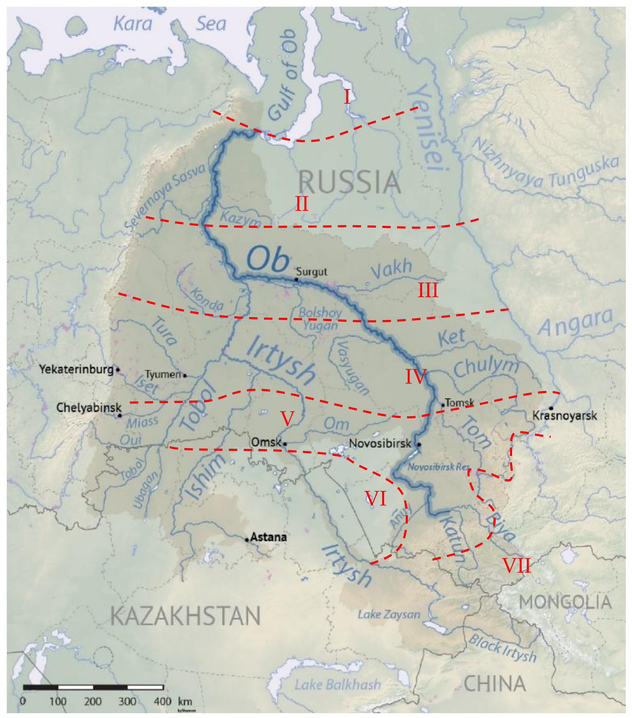
2. Materials and Methods

Research methodology, taking into account the recommendations of [1,3], was based on: (1) compiling and analyzing the equation of the ionic balance of river waters; (2) comparison of the results obtained with generalized data on the levels, discharges, chemical composition, and TDS (total dissolved solids) of river and groundwater in various landscape zones.
The equation for the major ions balance of river waters was presented as a mixing equation for water of the Ob and its main tributaries, similar to the calculation algorithm of the mixing of river and waste waters:
C O b , x = C K t , m + C B y , m C K t , m n max K t B y , x + i N t r C t r , i C O b , x Δ x n max t r , i , x + f x ,
n s u m = C t r C b c C O b , x C b c = n m × n 0 ,
n m r , i = γ i · Q + q i q i ,  
γ i = 1 exp α i × L x 3 1 + Q q i · exp α i × L x 3 ,
α i = φ × ε × D q i 3 ,
                D = g × h a × v a 37 × k r × k C h 2 ,
k C h = h a 1 6 k r ,  
n m w r , i = 1 + 0.412 × k x 0.627 + 0.0002 × k x ,
k x = L x 6.53 · h L 1.167 ,
f x = a 0 + a 1 × x + a 2 × x 2 + a 3 × x 3 ,  
where COb,x and COb,x−Δx are the sums of the main TDS ions (mg L−1); the sum of concentrations of Ca2+, Mg2+, Na+, K+, HCO3, CO32−, SO42−, and Cl in water of the Ob River at the distance of x and (x−Δx) from the confluence of the rivers of Katun and Biya; Δx = 0.5 km is the step along the length of the Ob; CKt,m and CBy,m are the sums of the major ions in the Katun and Biya waters (adopted from the measurements in the lower reaches of the Katun River at Srostki and the Biya River at Biysk); Ctr,i is the sum of the major ions in the water of the i-th tributary of the Ob (i = 1,…, Ntr); Cbc is the sum of major ions in the Ob at the “reference” cross-section (upstream from the mouth of the tributary); nmax(Kt−By),x and nmax(tr),i,x are the maximum (within reach of the mouth of tributary to the target section x) values of the basic dilution multiplicity nm in Equation (2) under the assumption that the initial dilution multiplicity n0 tends to one and the total dilution multiplicity nsum is approximately equal to the multiplicity of basic dilution nm; in the case of rivers, the calculation of the of basic dilution multiplicity of the i-th tributary water with water of the Ob nm(r),i was performed approximately using the Frolov–Rodziller method according to Equations (3)–(7) and, in the case of dilution in the Novosibirsk reservoir nm(wr),i, using the Ruffel method according to Equations (8) and (9) [18]; Q and qi are the water discharge in the Ob and in the i-th tributary, m3/s; γ is the coefficient of mixing; α is the coefficient of hydraulic conditions; D is the coefficient of hydrodispersion, m2/s; ha is the average depth of the Ob in the cross-section x, m; va is the average water flow velocity in the Ob River in the section x, m/s; kCh is the Chezy coefficient, m0.5/s; kr is the coefficient of roughness; g is the acceleration of gravity, m/s2; Lx is the distance from mouth of the study tributary to the target cross-section x in the river Ob; ϕ is the tortuosity coefficient; ε is the coefficient of mixing conditions (assumed ε = 1); hL is the average depth in the reach of the maximum influence of the tributary (assumed to be 250 m), m; f(x) is the correcting function reflecting changes in the conditions for the formation of the ion flow of the river and groundwater along the length of the river (inflow of groundwater and surface water, next to the main tributaries included in the model), taking into account the results of modeling the hydrochemical flow of the Angara River [19]; a0, a1, a2, a3 are the regression coefficients obtained for the difference between the computations by Equation (10) at f(x) = 1 and the values obtained from direct measurements.
Based on hydrometric observation data, a longitudinal profile was constructed for the mean annual water discharges of the Ob River and its tributaries, as well as the underground component, calculated as the arithmetic mean of the monthly groundwater discharge calculated by the equation:
Q g r j = Q j ,   j = 1 ,   2 ,   3 ,   12 Q 3 + Q 12 Q 3 · j 3 12 3 ,   4 j 11 ,
where Qj is the total discharge of river for the j-th month of the calendar year. Estimated values of current velocities and depths of the Ob at observation sites (Barnaul, Novosibirsk, Dubrovino, Kolpashevo, Prokhorkino, Belogorye, and Salekhard) were obtained from empirical dependencies from the observed water discharges Q and between the cross-sections used for regular observations through linear interpolation. Water discharges of the tributaries to the Ob were computed at their mouths as the product of the water flow modulus at the observation site and the total catchment area of the tributary. Sums of the major ions were determined from Equation (12) under assumption (13):
      C j = C 0 × Q j Q a k C k Q ,
      d C d t = d C d Q × d Q d t = d C d Q × k Q × Q = k C × C ,
where Qj and Cj are the computed water discharge and the corresponding concentration of the substance; Qa and C0 are the average long-term water discharge and the corresponding concentration, approximately expressed through the geometric means, which, in turn, can be considered as a conditional equilibrium value [13,20]; kC and kQ are the specific rates of change in the substance concentration and water flow rate, assuming kC/kQ ≈ const. The values of C0, kC, and kQ were determined using the least-squares method based on the data of joint hydrometric and hydrochemical observations under conditions (14), taking into account recommendations by [21,22]:
a j 2 × δ a , j ;   r 2 × δ r ; N 6 ;   R 2 0.36 ,  
    δ r 1 r 2 N 1 ,
  δ A σ N ,
where aj and δa,j are the regression coefficient and the error of its determination; r and δr are the correlation coefficient and the error of its determination by Equation (15); N is the sample size; R2 is the square of the correlation coefficient; σ is the standard deviation.
Comparison and analysis of hydrochemical and hydrogeological data in the framework of the study under consideration consisted mainly of the refinement of previously obtained data. The method of analysis included the calculation of statistics (arithmetic and geometric means, coefficients of variation and asymmetry, errors in their determination, including the error of determining the arithmetic mean by formula (16)) and testing for randomness by Pitman criterion and homogeneity by Wilcoxon and Fisher criteria. These procedures are described in more detail in [12,23,24].
The data were provided by the network of state monitoring of water bodies (rivers, the Roshydromet (Federal Service for Hydrometeorology and Environmental Monitoring); groundwater, the Federal State Budgetary Institution “Gidrospetsgeologiya”, JSC “Tomskgeomonitoring”, Tomsk Geological Exploration Expedition), and materials of scientific research and engineering surveys (Tomsk Polytechnic University, Tomsk branch of the Institute of Petroleum Geology, and Geophysics SB RAS, Ingeotech LLC) from the 1950s until 2021. The dataset on the chemical composition of river and groundwater exceeded 23 thousand samples, including materials obtained directly by the authors between 1994 and 2021. Data included pH value, permanganate oxidizability (PO) and COD, the sum of the major TDS (Ca2+, Mg2+, Na+, K+, HCO3, CO32−, SO42−, Cl), Si, Fe (total), phosphates, and NO3, NO2, NH4+ ions. The main condition for data generalization was the use of the same (or compatible) certified methods and requirements in accredited laboratories (Roshydromet, JSC Tomskgeomonitoring, TPU). All measurements of water flow rates were carried out in the subdivisions of Roshydromet. We also used data from regime observations of groundwater levels in the territory of the Siberian Federal District, according to the methods described in or identical to [25,26].
The main objects under study were the rivers of Ob, Biya, Katun, Peschanaya, Charysh, Alei, Chumysh, Berd, Inya, Tom, Chulym, Shegarka, Chaya, Parabel, Ket, Vasyugan, Tym, Vakh, Trom-Yugan, Bolshoi Yugan, Bolshoi Salym, Irtysh, Kazym, Northern Sosva, Poluy, and Shchuchya (Table 1). Most of the above-listed tributaries of the Ob, according to Ref. [27], corresponded to a category of “mid-size” rivers” with a catchment area from 2000 to 50,000 km2, reflecting the zonal conditions for the formation of water and hydrochemical runoff. A number of tributaries, such as the Ob itself, corresponded to a category of “big rivers” and were selected taking into account the expected impact on the flows of the Ob River.

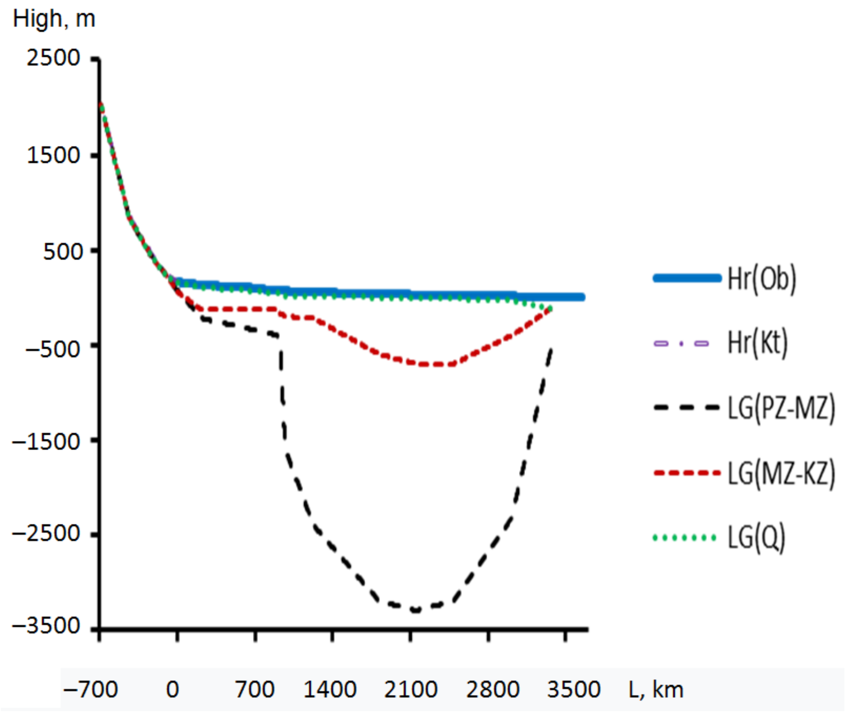
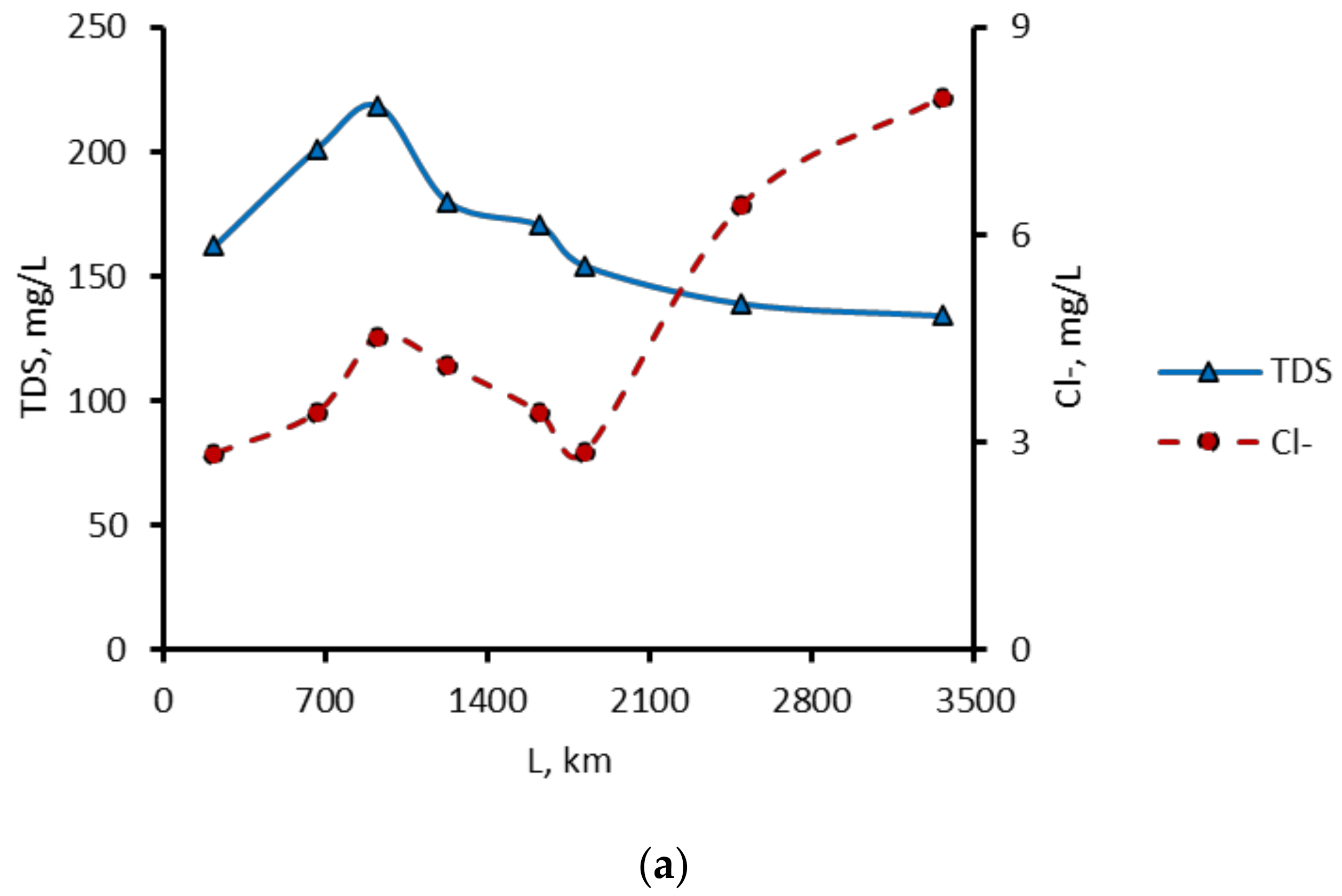
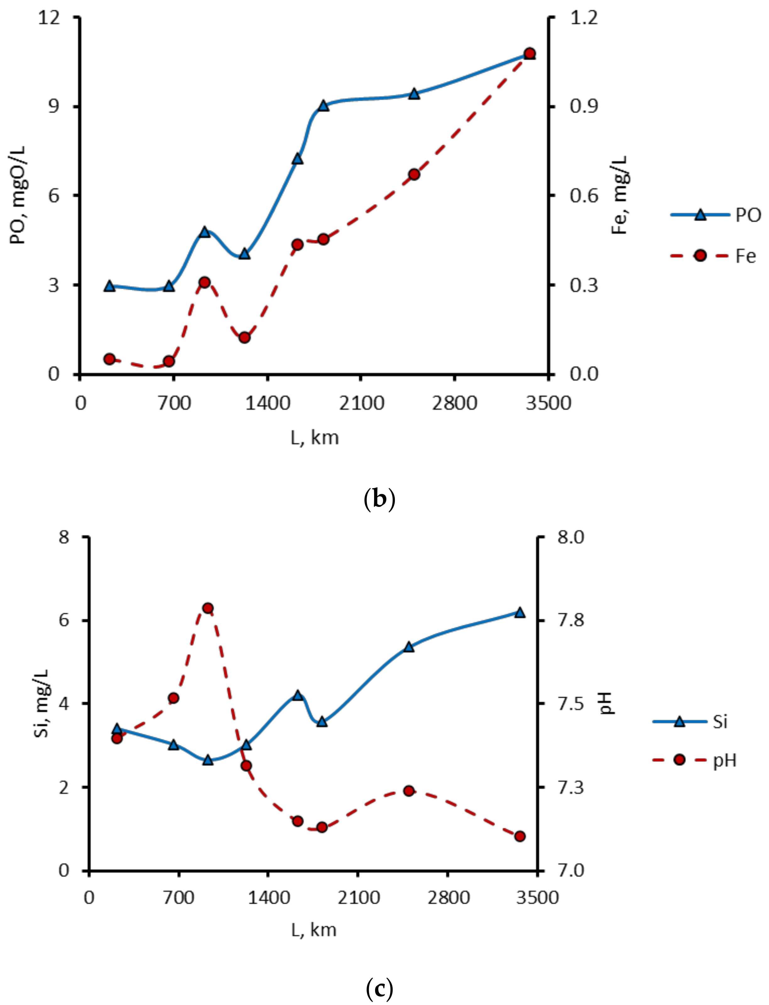
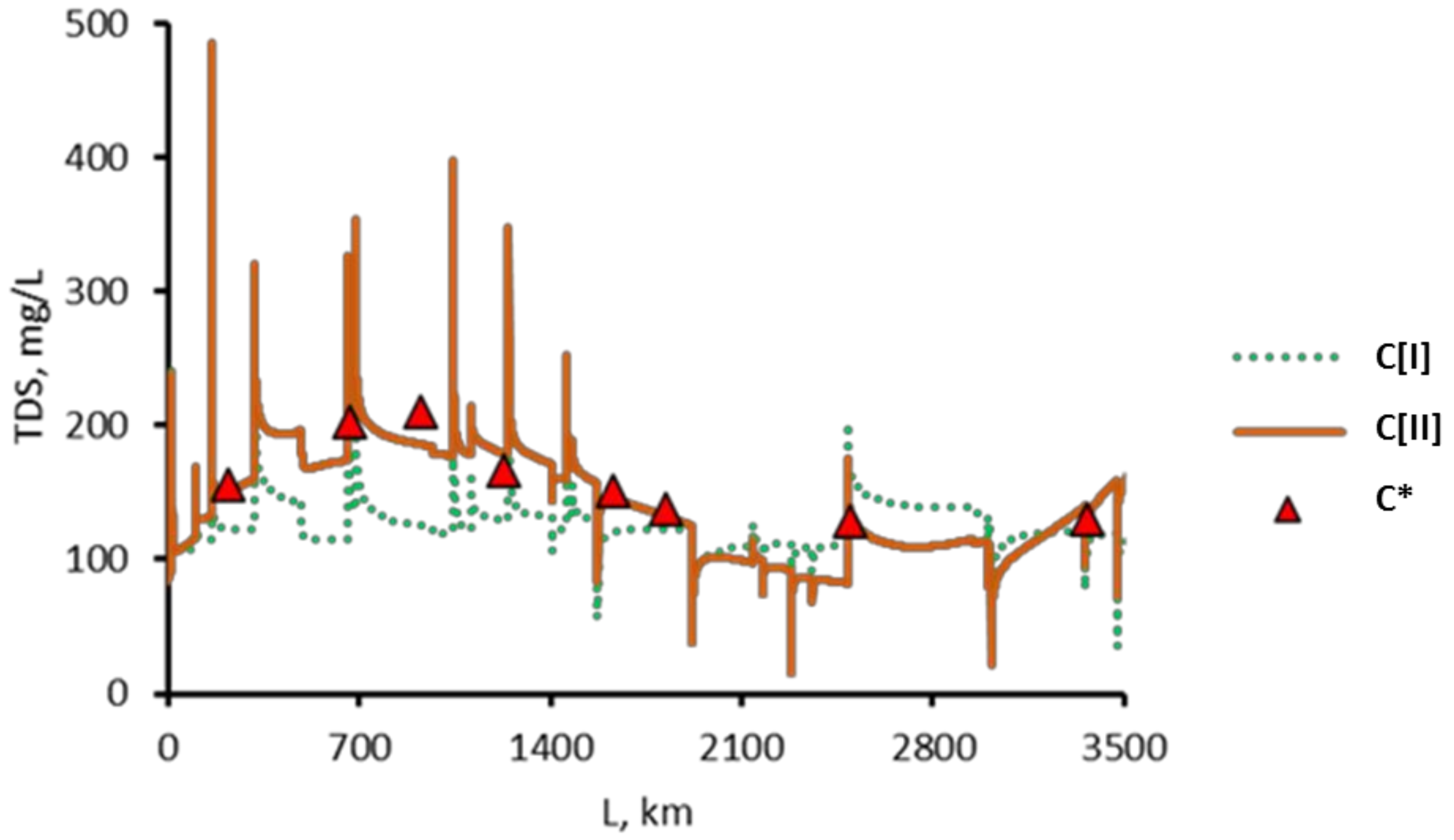
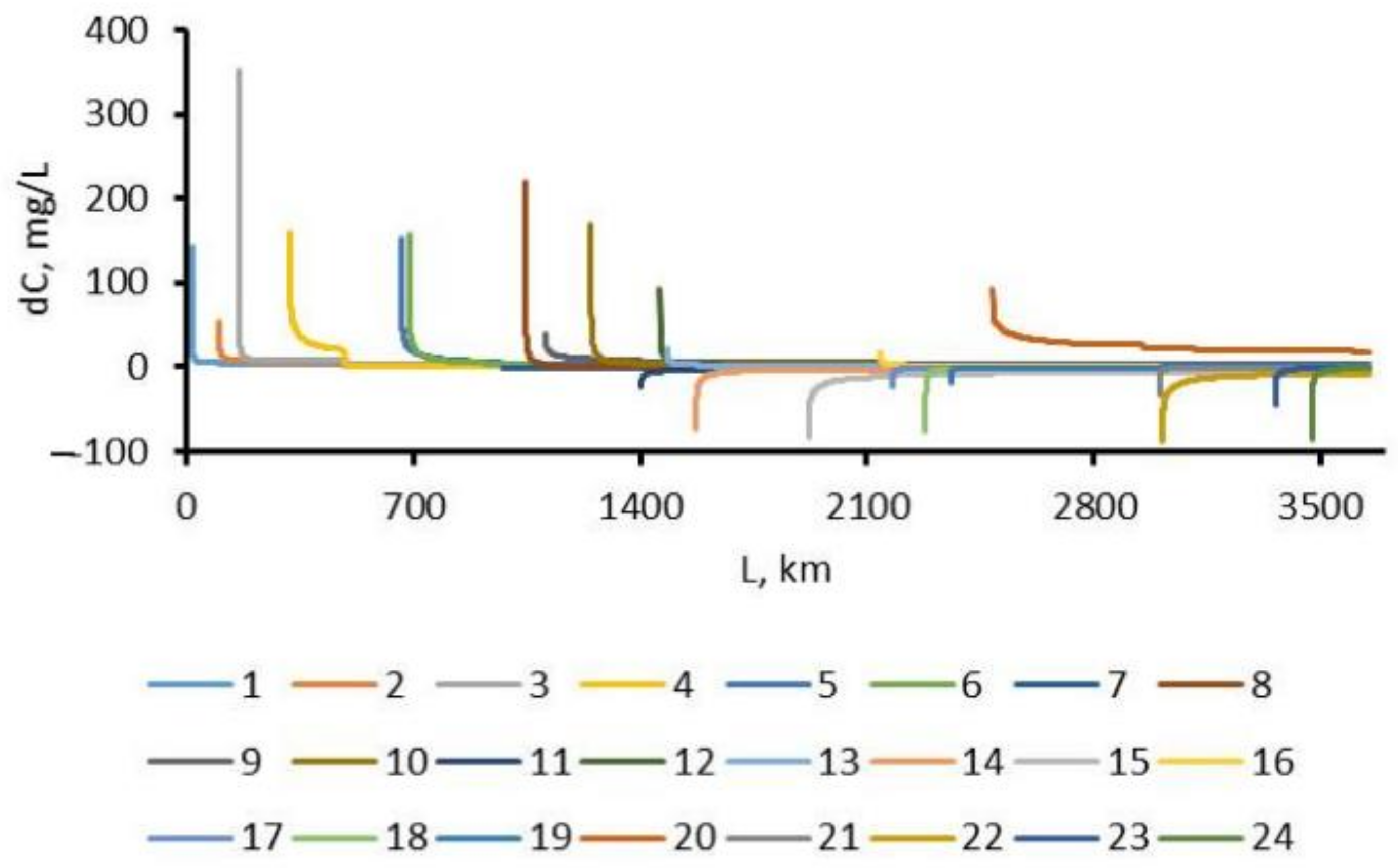
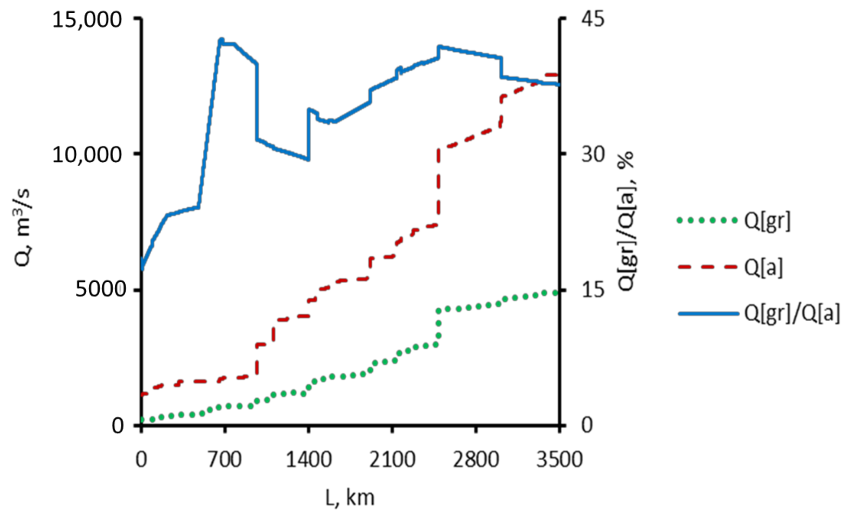
3. Results and Discussion

The river water of the Ob, according to the Alekin classification [28], was averagely fresh with low concentrations of dissolved ions (TDS < 200 mg L−1), bicarbonate calcium of the first type (CIICa), pH-neutral within the forest steppe area of the basin with an average concentration of dissolved solids (200 mg L−1 < TDS< 500 mg L−1), and slightly alkaline. From the confluence of the Katun and Biya rivers up to Salekhard, there was a general decrease in TDS, concentrations of Ca2+, HCO3−, SO42−, and NO3, and an increase in permanganate (PO) and chemical oxygen demand (COD) and contents of Cl, Si, and Fe (Figure 3). However, these changes in different areas can change direction, which in many cases might be explained not so much by anthropogenic influence (as one might think), but by the peculiarities of the natural conditions for the formation of water runoff and the chemical composition of natural waters. So, a sharp increase in Cl concentrations in the lower reaches of the Ob was explained by the inflow of the Irtysh water formed in the steppe and forest steppe areas, which were characterized by a high (for river water) content of dissolved substances, in general, and chloride ion, in particular (Figure 3a). The impact of wastewater can certainly be identified, especially in cities. However, this influence (for example, the inflow of underground saline water used in the pressure maintenance system in facilities for production of hydrocarbons) was still less than the influence of the inflow of fresh water, with a low content of dissolved substances incoming from the swampy areas of the southern and middle taiga (Table 2).
Predominantly natural causes could also explain the increase in the concentration of organic substances from the south to the north (according to COD). The main factor was very high bogging of the flat areas and, in southern taiga, intensive bogging continued at a rate of vertical growth of the peat deposit depth up to 1 mm/year and even more [29,30]. Accordingly, both organic matter and the products of its decomposition and transformation, including compounds with metals, entered the river network with swamp waters. Some of them had low solubility and were deposited in floodplains (for example, humates) and some were capable of long-range transportation in the form of colloids and suspended particles, in particular iron, the gross content of which (the sum of dissolved, colloidal, and suspended forms) varied along the length of the Ob almost synchronously with the value of permanganate oxidizability (Figure 3b). We also noted that, from the south to the north (within the flat part of the Ob basin), there was a general decrease in the pH value in the Ob and a certain increase in Si concentrations (Figure 3c). The latter trend was inversely proportional to the decrease in the average diameter of the sand particles in the channel and floodplain sediments from the confluence of the Biya and Katun rivers downstream to the city of Salekhard and, apparently, was associated both with the influx of products of destruction of bottom sediments and underlying rocks and with a decrease in the intensity of Si output processes from the solution (for example, according to [28], a decrease in consumption by aquatic organisms from the south to the north).
Water of small (catchment area up to 2000 km2) and medium (2000–50,000 km2) rivers reflecting local (azonal) and zonal conditions for the formation of water and hydrochemical runoff (in contrast to the hyperzonal rivers of the Ob, Irtysh, Tom, Chulym, and some others) were characterized by a very diverse chemical composition and total content of dissolved substances from fresh with low and medium TDS values, bicarbonate calcium waters in mountainous areas and in the northern part of the Ob basin (mountain taiga in the south of the basin, northern taiga, forest tundra, and tundra) to brackish (according to [31] at TDS 1–10 g L−1), bicarbonate sodium, and even chloride sodium in the forest steppe and steppe territories (Table 2; in this table, PO and COD are permanganate and dichromate oxidizability, mgO/L; TDS is total dissolved substances; TDS and content of dissolved substances are in mg/L; type of water by [28]: “C” corresponds to predominance of ion HCO3, “Ca” corresponds to predominance of ion Ca2+; type from I to IV is determined by the ratio of main ions and indicates the origin of water). The highest concentrations of organic matter (according to COD and PO) in the tributaries of the Ob were usually observed in the taiga zone against the background of intensive modern swamp formation. The concentrations of nitrates and phosphates outside the wastewater discharge zone (up to 8 km on the Tom and Ob rivers) were generally not high and usually did not exceed the standards for the quality of domestic and drinking water established in the Russian Federation. The situation was somewhat worse with the concentrations of NH4+ and NO2 and, especially, Fe, which was most often associated with the inflow of swamp water. At the same time, we noted that the influence of the latter factor was traced not only in the taiga zone, forest tundra, and tundra, but also in other natural zones due to the waterlogging in river valleys [12]. Across the territory, there was a general decrease in the content of dissolved substances from the south-southwest to the north-northeast, against which there was a difference in the chemical composition of river water within the same natural zones, for example, higher TDS values in the left-bank part of the basin in areas of middle and lower reaches compared with the right bank [12,23].
In general, both river and groundwater were characterized by a regular increase in the total content of dissolved solids as the intensity of water exchange decreased. With this in mind, dependencies of the form (12) between the total content of the main ions (TDS) and water discharges Q were obtained for river water, which were then used to model the distribution of TDS along the stem of the Ob (Table 3).
Analysis of the simulation results showed that, firstly, the mixing of the Ob River water and the water of its tributaries was satisfactorily described by Equations (2)–(9) in the longitudinal section of 1800–2200 km downstream from the Katun and Biya rivers’ confluence (a section that spans approximately from the Aleksandrovskoye settlement in the Tomsk region to the mouth of the Bolshoy Yugan River) (Figure 4).
In other areas, a satisfactory convergence of the calculated and measured values was achieved only when using the correcting function f(x), the values of which were at a maximum in the forest steppe and southern taiga sections of the Ob. In these sections, those tributaries entered the Ob, the flows of which were formed in more than a single landscape zone (the rivers of Tom, Chulym, Kiya, and Chumysh). The minimum values of f(x) corresponded to areas in the middle taiga subzone that had a maximum thickness of Mesozoic–Cenozoic deposits (Figure 2), which were quite homogeneous in terms of natural conditions. At the same time, we noted that the TDS peaks in Figure 4 and Figure 5 formally corresponded to values directly related to the water of the immediate tributaries.
Secondly, the effect of most tributaries on the long-term average concentrations of major ions usually did not exceed the distance of 4–6 km, both in the direction of increasing or decreasing TDS. The only exceptions were the rivers of Chumysh (an increase in TDS in the section up to 25.5 km in length), Vakh (a decrease within 47 km), Severnaya Sosva (a decrease within 54.5 km), and, especially, the Irtysh. Downstream of the Irtysh mouth, there was a noticeable increase in TDS indicated at a distance up to 636.5 km (Figure 5). We especially noted that this conclusion referred to the distribution of the major ions in water; the distribution of other dissolved substances might be considerably different.
Thirdly, changes in TDS values corresponding to the average annual long-term water discharge and its underground component were proportional to each other; the differences were mainly in the higher contents of the major ions, which on average corresponded (according to the Alekin classification) to the category “fresh water with average mineralization” (Figure 6). Taking into account the calculated ratio of water runoff and its underground component (Figure 7), this indirectly indicated that mainly fresh groundwater entered the river network (a sharp increase in the share of the underground component in the upper Ob section reflected the peculiarities of the calculation method within the boundaries of the Novosibirsk reservoir). Such waters can be present within the ARGO both in the Mesozoic–Cenozoic deposits and in the zone of fracturing of the Paleozoic formations, as well as in the WSAB (mainly in the aquifers of the Neogene–Quaternary and Paleogene age) (Table 2).
Fourthly, the distribution of the ion runoff (in absolute terms, e.g., in tons per year) along the length of the Ob River and, accordingly, in the area of the Ob basin was extremely uneven and was characterized by its growth from a confluence of the Katun and Biya rivers situated approximately downstream of the mouth of the Vasyugan River, followed by a decline to the mouth of the Irtysh River, and a sharp increase as a result of the confluence with the Irtysh and after the confluence of the Northern Sosva River (Figure 8). The groundwater component of the Ob ion runoff in absolute terms changed more smoothly but also increased sharply as a result of the confluence with the Irtysh River. A slightly different dynamic of downstream changes along the Ob was observed in the relative share of underground component, which more or less steadily increased to the mouth of the Irtysh River and then decreased down to the Gulf of Ob (Figure 8).
According to the authors, attention should be paid to the decrease in the total ion runoff of the Ob River in the middle taiga subzone with the maximum thickness of the sedimentary cover of Mesozoic–Cenozoic deposits (Figure 1 and Figure 8), taking into account the fact that this indirectly indicated the possibility of the accumulation of part of the dissolved substances coming with the surface and groundwater formed in the mountainous areas of ASGO and the Paleozoic basement in the central part of the WSAB. Under certain conditions (for example, a relatively sharp deterioration in the filtration properties of rocks), this can additionally contribute to the removal of a number of substances up to the formation of geochemical anomalies (including iron compounds), not only in the direction of river water flow but also along the general slope of relief and aquifers here. Such a possibility was indirectly evidenced by the data on changes in the surface topography and groundwater levels in the upper hydrodynamic zone along the profiles in the right- and left-bank parts of the Ob River basin in its middle course (Figure 9). In the first case, more favorable conditions for the movement of groundwater were observed (a higher content of sand particles, fewer aquicludes made from clay deposits, and higher gradients of groundwater levels), and, respectively, less interaction time in the water–rock system and the total content of dissolved solids in ground and river water. The opposite picture was in the left-bank area of the middle Ob basin (Table 2).
The analysis of changes in the ion flow of the Ob River should be carried out taking into account changes in the underground hydrosphere, in particular, an increase in groundwater levels in the southern and middle taiga subzones by about 0.3 m (noted by a number of authors [4,24]) and permafrost degradation in the northern part of the Ob basin.
The spatial regularities considered and discussed in the paper, as well as the model presented, might be checked and applicable for organization and analysis of multiple field data on river water chemistry (e.g., [32,33,34]) that has been collected during the last decades by different research groups on a river basin scale.

4. Conclusions

The analysis of observation data on the chemical composition of river and groundwater in the basin of the Ob has been carried out. A model describing the change in the total content of the major ions in river water along its length has been developed. As a result, quantitative estimates of the total ion runoff and its underground component were obtained, on the basis of which, the following conclusions were drawn: Firstly, the uneven distribution of the ion runoff over the territory of the Ob River basin was noted. Secondly, in the mountain regions of the Ob basin and adjacent areas of the forest steppe and southern taiga, mainly the removal of dissolved solids was observed. Some of these substances were accumulated in underground horizons at the boundary of the southern and middle taiga, directly in the middle taiga subzone and, above all, in areas with less intense water exchange in the left bank of the middle Ob.
Thirdly, the influence of the main tributaries on the total content of dissolved solids was generally limited to the distance of several kilometers downstream of the mouths of main tributaries. The main exception was the Irtysh River, the largest tributary of the Ob, as well as the Chumysh and Severnaya Sosva rivers. Fourthly, the influence of groundwater was maximal in the forest steppe and southern taiga areas of the upper and middle Ob and minimal in the flat part of the lower reaches of the Ob River in zones of forest–tundra and tundra.

Author Contributions

Conceptualization, V.Z. and O.S.; methodology, O.S. and V.Z.; software, O.S.; validation, V.Z. and O.S.; formal analysis, O.S. and V.Z.; investigation, O.S. and V.Z.; resources, O.S.; data curation, V.Z. and V.P.; writing—original draft preparation, O.S.; writing—review and editing, V.Z., O.S. and V.P.; visualization, V.P. All authors have read and agreed to the published version of the manuscript.

Funding

The study was carried out by using the equipment of the Unique Research Installation “System of experimental bases located along the latitudinal gradient” TSU, with financial support from the Ministry of Education and Science of Russia (RF-2296.61321X0043, 13.yHy.21.0005, agreement No. 075-15-2021-672), and O.S. also was supported by the Russian Science Foundation, project no. 23-27-00039. The APC was funded by MDPI.

Data Availability Statement

Publicly available data were analysed. The data that support the findings of this study are available from the corresponding author upon reasonable request.

Conflicts of Interest

The authors declare no conflict of interest.

References

  1. Loucks, D.P.; Van Beek, E. Water Resources Systems Planning and Management. An Introduction to Methods, Models and Applications; UNESCO Publishing: Turin, Italy, 2005; printed by Ages Arti Grafiche; 679p. [Google Scholar]
  2. Kalbus, E.; Reinstorf, F.; Schirmer, M. Measuring methods for groundwater—surface water interactions: A review. Hydrol. Earth Syst. Sci. 2006, 10, 873–887. Available online: www.hydrol-earth-syst-sci.net/10/873/2006 (accessed on 5 June 2023). [CrossRef]
  3. Benedini, M.; Tsakiris, G. Water Quality Modelling for Rivers and Streams; Springer: Dordrecht, The Netherlands, 2013; 288p. [Google Scholar]
  4. Shiklomanov, A.I.; Lammers, R.B.; Lettenmaier, D.P.; Polischuk, Y.M.; Savichev, O.G.; Smith, L.G. Hydrological changes: Historical analysis, contemporary status, and future projections. In Environmental Changes in Siberia: Regional Changes and Their Global Consequences; Groisman, P.Y., Gutman, G., Eds.; Springer: Berlin, Germany, 2013; pp. 111–154. Available online: http://link.springer.com/chapter/10.1007/978-94-007-4569-8_4 (accessed on 5 June 2023).
  5. Shiklomanov, A.; Déry, S.; Tretiakov, M.; Yang, D.; Magritsky, D.; Georgiadi, A.; Tang, W. River freshwater flux to the Arctic Ocean. In Arctic Hydrology, Permafrost and Ecosystems; Yang, D., Kane, D., Eds.; Springer: Berlin, Germany, 2021; pp. 703–738. [Google Scholar] [CrossRef]
  6. Hydrogeology of the USSR. In The West Siberian Plain (Tyumen, Omsk, Novosibirsk and Tomsk regions); Nudner, V.A. (Ed.) Nedra Publ.: Moscow, USSR, 1970; Volume 16, 368p. (In Russian) [Google Scholar]
  7. Hydrogeology of the USSR. In Kemerovo Region and Altai Territory; Nedra Publ.: Moscow, USSR, 1972; Volume 17, 398p. (In Russian)
  8. State of the Geological Environment in the Territory of Siberian Federal District in 2017; Bulletin; Filial «Sibirskiy regional’nyy tsentr GMSN», FGBU «Gidrospetsgeologiya»: Tomsk, Russia, 2018; Volume 14, 178p. (In Russian)
  9. Adam, A.M. Assessment of the ecological state of the territory of Western Siberia in order to ensure environmental safety in the context of sustainable nature management. In Nature Protection; NTL Publ.: Tomsk, Russia, 2005; pp. 1–12. [Google Scholar]
  10. Water Resources of the Russian Federation in 2018: State and Uses; Government Report; NIA-Priroda: Moscow, Russia, 2019; 290p. (In Russian)
  11. Zemtsov, V.A.; Savichev, O.G. Resources, regime and quality of surface waters in the Ob River basin: History, current state and problems of research. Intern. J. Environ. Stud. 2015, 72, 386–396. [Google Scholar] [CrossRef]
  12. Savichev, O.G. Water Resources of the Tomsk Region; Tomsk Polytechnic University Publ.: Tomsk, Russia, 2010; 248p. (In Russian) [Google Scholar]
  13. Savichev, O.G. Hydroecological Substantiation of Water Management Decisions; Tomsk Polytechnic University Publ. House: Tomsk, Russia, 2021; 167p. [Google Scholar]
  14. Georgievsky, M. Water resources of the Russian rivers and their changes. Proc. IAHS 2016, 374, 75–77. [Google Scholar] [CrossRef]
  15. Groisman, P.; Bulygina, O.; Henebry, G.; Speranskaya, N.; Shiklomanov, A.; Chen, Y.; Tchebakova, N.; Parfenova, E.; Tilinina, N.; Zolina, O.; et al. Dryland belt of Northern Eurasia: Contemporary environmental changes and their consequences. Environ. Res. Lett. 2018, 13, 115008. [Google Scholar] [CrossRef]
  16. Bui, M.T.; Lu, J.; Nie, L. A Review of Hydrological Models Applied in the Permafrost-Dominated Arctic Region. Geosciences 2020, 10, 401. [Google Scholar] [CrossRef]
  17. Gelfan, A.N.; Gusev, E.M.; Kalugin, A.S.; Krylenko, I.N.; Motovilov, Y.G.; Nasonova, O.N.; Millionshchikova, T.D.; Frolova, N.L. Runoff of russian rivers under current and projected climate change: A review 2. climate change impact on the water regime of russian rivers in the xxi century. Water Resour. 2022, 49, 351–365. [Google Scholar] [CrossRef]
  18. Methodology for Developing Standards for Permissible Discharges of Substances and Microorganisms into Water Bodies for Water Users. 17.05.2021; Ministry of Nature Resources of Russia Publ.: Moscow, Russia, 2021; 46p. (In Russian)
  19. Savichev, O.G.; Matveenko, I.A. Evaluation of chemical composition changes of surface water in Boguchan Reservoir (Siberia, Russia). Hydrol. Sci. J. 2013, 58, 706–715. [Google Scholar] [CrossRef]
  20. Savichev, O.G.; Zemtsov, V.A.; Pasechnik, E.Y. Hydrologic conditions for chemical composition of the Siberian river waters. Aktru IOP Conf. Ser. Earth Environ. Sci. 2019, 232, 1–6. [Google Scholar] [CrossRef]
  21. Nash, J.E.; Sutcliffe, J.V. River flow forecasting through conceptual models. P. I. A discussion of principles. J. Hydrol. 1970, 10, 282–290. [Google Scholar] [CrossRef]
  22. Determination of the Main Calculated Hydrological Characteristics. SP 33-101-2003. Code of Rules for Design and Construction; Gosstroy of Russia Publ.: Moscow, Russia, 2004; 72p. (In Russian)
  23. Ivanova, I.; Savichev, O.; Trifonov, N.; Kolubaeva, Y.V.; Volkova, N. Major-Ion Chemistry and Quality of Water in Rivers of NorthernWest Siberia. Water 2021, 13, 3107. [Google Scholar] [CrossRef]
  24. Savichev, O.; Moiseeva, J.; Guseva, N. Changes in the groundwater levels and regimes in the taiga zone of Western Siberia as a result of global warming. Theor. Appl. Climatol. 2022, 147, 1121–1131. [Google Scholar] [CrossRef]
  25. Weight, W.D. Hydrogeology Field Manual, 2nd ed.; The McGraw-Hill Education: New York, NY, USA, 2008; 751p. [Google Scholar]
  26. Manual on Stream Gauging. Vol. I. Fieldwork. WMO. No. 1044; World Meteorological Organization: Geneva, Switzerland, 2010; 252p.
  27. State Standard. Working Document GOST 19179-73 Land Hydrology. Terms and Definitions; Gosstandart USSR: Moscow, Russia, 1988; 47p. (In Russian) [Google Scholar]
  28. Alekin, O.A. Fundamentals of Hydrochemistry; Gidrometeoizdat: Leningrad, Russia, 1970; 444p. (In Russian) [Google Scholar]
  29. Liss, O.L.; Abramova, L.I.; Avetov, N.A. Bogs of Western Siberia and Their Conservation Value; Grif & Ko Publ.: Tula, Russia, 2001; 584p. (In Russian) [Google Scholar]
  30. Pologova, N.N.; Lapshina, E.D. Carbon accumulation in peat bog deposits of the Great Vasyugan. In Big Vasyugan Bog. Current Status and Development; Institute of Atmospheric Optics SB RAS Publ.: Tomsk, Russia, 2002; pp. 174–179. (In Russian) [Google Scholar]
  31. State Standard. Working Document GOST 27065–86 Water Quality. Terms and Definitions; Publishing House of Standards: Moscow, Russia, 2003; 9p. (In Russian) [Google Scholar]
  32. Pokrovsky, O.S.; Manasypov, R.M.; Kopysov, S.G.; Krickov, I.V.; Shirokova, L.S.; Loiko, S.V.; Lim, A.G.; Kolesnichenko, L.G.; Vorobyev, S.N.; Kirpotin, S.N. Impact of permafrost thaw and climate warming on riverine export fluxes of carbon, nutrients and metals in Western Siberia. Water 2020, 12, 1817. [Google Scholar] [CrossRef]
  33. Pokrovsky, O.S.; Manasypov, R.M.; Loiko, S.V.; Shirokova, L.S.; Krickov, I.A.; Pokrovsky, B.G.; Kolesnichenko, L.G.; Kopysov, S.G.; Zemtzov, V.A.; Kulizhsky, S.P.; et al. Permafrost coverage, watershed area and season control of dissolved carbon and major elements in western Siberian rivers. Biogeosciences 2015, 12, 6301–6320. [Google Scholar] [CrossRef]
  34. Kolesnichenko, I.; Kolesnichenko, L.G.; Vorobyev, S.N.; Shirokova, L.S.; Semiletov, I.P.; Dudarev, O.V.; Vorobev, R.S.; Shavrina, U.; Kirpotin, S.N.; Pokrovsky, O.S. Landscape, Soil, Lithology, Climate and Permafrost Control on Dissolved Carbon, Major and Trace Elements in the Ob River, Western Siberia. Water 2021, 13, 3189. [Google Scholar] [CrossRef]
Figure 1. Location of the study area; I—tundra; II—forest–tundra and northern taiga; III—middle taiga; IV—southern taiga; V—forest steppe; VI—steppe; VII—mountains. Permafrost corresponds to the boundaries of the tundra, forest–tundra, and northern taiga (island permafrost), as well as in the mountain glacial regions of Altai and the Northern Urals). (CC BY-SA 4.0, https://commons.wikimedia.org/w/index.php?curid=66496514 (accessed on 5 June 2023).
Water 15 02413 g001
Figure 2. Schematic longitudinal geological section of the Katun River (from −688 to 0 km on a horizontal axis) and Ob River basin (from 0 to 3650 km). Hr(Ob) is the average long-term water level of the Ob; Hr(Kt) is the average long-term water level of the Katun; LG(PZ-MZ) is the conditional dividing line between Paleozoic and Mesozoic deposits; LG(MZ-KZ) is the conditional dividing line between Mesozoic and Cenozoic deposits; LG(Q) is the line of the base of the Quaternary deposits (the scheme was compiled by the authors according to the data of [6,7,8]).
Water 15 02413 g002
Figure 3. Changes in the means of hydrochemical parameters along the Ob River length. Subfigure (a): TDS and chloride Cl- concentration, mg/L, (b): permanganate oxidizability (PO) and total iron (Fe) concentration, mg/L; (c): silicon concentration (Si), mg/L and pH.
Water 15 02413 g003aWater 15 02413 g003b
Figure 4. Changes in the means of TDS in the Ob under conditions of average long-term water flow; C[I]—calculated values without f(x); C[II]—calculated values taking into account f(x); C*—values corresponding to C0 in Table 3.
Water 15 02413 g004
Figure 5. Estimated influence of the main tributaries on TDS in the Ob River water under conditions of the average annual water flow: dC = (Ctr − Cbc)/n0, where Ctr is TDS in inflow water; Cbc—TDS in the Ob River at a distance of 0.5 km upstream of the mouth of a certain tributary; n0 is the multiplicity of basic dilution of the tributary water; numbers of tributaries are given in Table 1.
Water 15 02413 g005
Figure 6. Changes in the TDS means in the Ob River under average long-term water flow (C[a]) and its underground component (C[gr]).
Water 15 02413 g006
Figure 7. Changes in the mean water discharge Q[a] of the Ob River, its underground component Q[gr], and the share of the underground component Q[gr]/Q[a] along the river length.
Water 15 02413 g007
Figure 8. Changes in the means of the ion flow of the Ob G[a] = Q[a]×C[a], its underground component G[gr], and the share of the underground component G[gr]/G[a] along the length of the river.
Water 15 02413 g008
Figure 9. Schematic latitudinal relief profiles and marks of groundwater levels of the upper hydrodynamic zone in the right-bank area (top: the upper reaches of the Kiya River at Makaraksky, Kuznetsky Alatau (Kiya, Chulym, Ob), the Kiya River at Mariinsk, the Kiya River at Okuneevo, the Chulym River at Zyryanskoe, well 81r (deposit age 1QIII), the Ulu-Yul River at Argat-Yul, the Ket River at Beliy Yar, well 113r (N), the Paidugina River at Berezovka, the Tym River at Napas, well 156p (P2lg), the Vakh River at Laryak), and the left bank of the Ob River basin; down: the Ob River at Pobeda, Ob at Melnikovo, well 63r (P-Q), the Shegarka River at Babarykino, the Iksa River at Plotnikovo, the Chaya River at Podgornoye, well 94r (Q), the Parabel River at Novikovo, the Vasyugan River at Sredny Vasyugan, well 169r (P), the Bolshoy Yugan River at Ugut).
Water 15 02413 g009
Table 1. Morphometric and hydrologic parameters of the Ob River and its tributaries.
Cross-Section on the Ob River (Number)Lm, kmL, kmF*, km2River/Gauge StationF(s), km2Q(gr)/
Q(s),%
M(s), L/
(s⋅km2)
M(gr), L/
(s⋅km2)
Mouth of the Shchuchya River (24)178347212,300Shchuchya at Shchuchye10,6001910.301.98
Salekhard city28733632,950,000Ob at Salekhard384.381.66
Mouth of the Poluy River (23)291335921,000Poluy at Poluy15,100328.832.79
Mouth of the Severnaya Sosva River (22)638301298,300Severnaya Sosva at Sosva, cultbaza65,200139.371.23
Mouth of the Kazym River (21)648300235,600Kazym at Verkhnekazymsky20,400383.761.45
Belogorie village115224982,160,000Ob at Belogorie424.671.97
Mouth of the Irtysh River (20)116224881,650,000Irtysh at Khanty-Mansiysk1,640,000441.700.75
Mouth of the Bolshoy Salym River (19)1291235918,100Bolshoy Salym at Lempyny12,500275.561.50
Mouth of the Lyamin River (18)1369228115,900Lyamin at Gorshkovo12,800469.314.24
Mouth of the Bolshoy Yugan River (17)1471217934,700Bolshoy Yugan at Ugut22,100246.751.61
Mouth of the Trom-Yegan River (16)1509214155,600Trom-Yegan at Russkinskaya8800509.544.74
Mouth of the Vakh River (15)1730192076,700Vakh at Lobchinnskoye56,4004310.464.47
Prokhorkino village20241626738,000Ob at Prokhorkino356.832.42
Mouth of the Tym River (14)2077157332,300Tym at Napas24,500378.343.08
Mouth of the Vasyugan River (13)2169148161,800Vasyugan at Sredniy Vasyugan31,700245.191.24
Mouth of the Parabel River (12)2189146125,500Parabel at Novikivo17,900304.311.27
Mouth of the Ket River (11)2246140494,200Ket at Rodionovo71,500726.484.64
Mouth of the Chaya River (10)2403124727,200Chaya at Podgornoye25,000313.190.98
Kolpashevo town24221228486,000Ob at Kolpashevo347.182.43
Mouth of the Chulym River (9)25421108134,000Chulym at Baturino131,000305.961.78
Mouth of the Shegarka River (8)2605104512,000Shegarka at Babarykino8190182.220.39
Mouth of the Tom River (7)267797362,000Tom at Tomsk57,0001818.233.29
Dubrovino village2876774258,000Ob at Dubrovino436.542.84
Mouth of the Inya River (6)296568517,600Inya at Kaily15,700232.190.51
Novosibirsk city, Hydroelectric station2986664232,000Ob at Novosibirsk426.602.80
Mouth of the Berd River (5)29896618650Berd at Maslyanino2480366.562.39
Mouth of the Chumysh River (4)333331723,900Chumysh at Talmenka20,600275.691.52
Barnaul city3430220169,000Ob at Barnaul238.702.03
Mouth of the Aley River (3)349016021,100Aley at Aleysk18,700281.530.43
Mouth of the Charysh River (2)355010022,200Charysh at Charyshsly sovkhoz20,700238.822.06
Mouth of the Peschanaya River (1)3634165660Peschanaya at Tochilnoye4720316.281.92
Mouth of the Katun River365060,900Katun at Srostki58,4001810.361.84
Mouth of the Biya River365037,000Biya at Biysk36,9002012.892.54
Note: Lm and L are the distance from the mouth and source of the Ob River, respectively; F* is the area of the Ob River basin in the section under consideration or the total catchment area of the tributary; F(s) is the catchment area of the tributary at the gauge station (hydrometric observation point); Q(gr)/Q(s) is the ratio of the average annual values of the groundwater component Q(gr) of the total water discharge Q(s); M(s) and M(gr) are mean long-term values of total and groundwater runoff modules.
Table 2. Arithmetic means (A) of hydrochemical characteristics of river and groundwater in the Ob basin and errors (δA) of their determination.
Natural AreaDistrict (Catchment)ParameterpHTDSNO3NH4+PO43−SiFePOCODType of Water
River waters (waters of medium and small rivers)
Mountainous areasTomA7.4698.61.370.190.433.430.113.147.52CIICa
δA0.023.80.080.010.390.090.020.180.20-
ChulymA7.63153.30.540.160.103.920.144.4811.79CICa
δA0.0410.00.080.090.070.150.020.574.57-
Ob areaA7.43207.31.661.000.154.530.154.6310.26CIICa
δA0.039.90.320.380.020.530.040.411.14-
AltaiA7.60141.70.670.060.062.920.512.335.24CIICa
δA0.055.40.050.010.010.270.140.210.42-
TotalA7.48126.11.250.190.293.500.213.257.45CIICa
δA0.023.30.060.010.230.110.030.140.19-
SteppeTotalA7.55987.20.530.100.173.320.1615.4941.47ClIINa
δA0.0667.60.12-0.030.260.031.905.94-
Forest steppeIrtyshA7.62629.9---4.840.2913.4244.23CIINa
δA0.0641.2---0.640.111.0110.96-
Upper Ob areaA7.65407.80.740.420.233.870.114.6413.53CICa
δA0.0314.40.100.060.030.180.020.240.69-
TomA7.48515.81.390.250.303.770.297.0822.52CICa
δA0.1433.00.570.110.110.400.080.820.98-
TotalA7.63481.30.880.400.234.040.177.1019.67CIICa
δA0.0315.80.140.050.030.180.020.430.95-
Southern taigaRight bankA6.91147.00.730.600.134.430.6515.2928.82CICa
δA0.0510.20.300.110.010.180.070.961.54-
Left bankA7.03242.32.692.250.294.801.6328.6366.92CIICa
δA0.038.20.460.170.030.150.181.262.85-
TotalA7.00220.42.252.120.254.711.4324.9858.10CIICa
δA0.036.90.360.160.020.120.141.002.34-
Middle taigaRight bankA6.6251.00.515.540.115.461.4713.3826.71CIICa
δA0.063.00.114.790.020.260.090.591.51-
Left bankA6.92101.60.311.510.355.242.5422.0857.48CIIICa
δA0.088.90.250.520.130.440.601.907.93-
TotalA6.7265.80.494.840.155.421.6514.6331.60CIICa
δA0.053.70.103.950.030.230.130.632.14-
Northern taiga, forest tundra, tundraRight bankA7.3168.8---3.300.4310.5915.41CIIICa
δA0.096.4---0.240.082.431.59-
Left bankA6.1967.00.270.300.196.121.2814.7038.41CIICa
δA0.107.70.080.070.060.550.151.493.83-
TotalA6.5767.80.270.300.194.710.9612.9829.31CIIICa
δA0.095.00.080.070.060.340.101.342.68-
Groundwater (age of aquifers)
Mountainous areasAltai (Q/N)A7.60410.33.460.270.065.211.170.94-CIIICa
δA0.1372.81.310.170.040.780.940.52--
Altai (Pz)A7.58342.830.240.070.035.170.121.67-CICa
δA0.0315.417.040.010.010.160.040.29--
Mountainous regions, foothills and adjacent territories of forest
steppe and taiga
Tom/Chulym (Q/N)A7.19425.82.760.880.338.483.822.743.38CICa
δA0.0819.01.930.120.270.640.590.210.51-
Tom/Chulym (P)A7.30479.50.370.530.109.643.712.539.44CICa
δA0.258.70.060.050.020.290.310.103.32-
Tom/Chulym (Mz)A7.30452.3-------CICa
δA0.2037.5--------
Tom/Chulym (Pz)A7.01870.91.120.591.877.633.102.408.70CINa
δA0.09260.30.480.071.180.260.350.142.23-
Forest steppeUpper Ob area (Q)A7.49646.8--0.045.272.45--CIICa
δA0.3297.6--0.011.591.05--
Upper Ob area (P)A7.50710.00.541.070.1012.391.282.55-CICa
δA0.1354.60.200.430.042.030.420.66--
Upper Ob area (Pz)A7.25672.95.091.240.177.025.432.00-CICa
δA0.2571.84.660.860.141.084.970.98--
Southern taigaRight bank (Q)A6.92223.30.351.200.015.648.754.91-CICa
δA0.057.30.070.100.000.360.880.24--
Left bank (Q)A7.09342.93.770.580.033.222.553.46-CIIICa
δA0.0711.51.970.090.020.250.320.13--
Total (Q)A6.97257.61.321.030.025.067.074.50-CICa
δA0.046.60.570.080.010.290.660.18--
Right bank (P)A7.19456.70.601.890.057.919.377.53-CICa
δA0.0914.00.190.160.020.621.610.50--
Left bank (P)A7.23464.91.412.992.336.926.185.68-CICa
δA0.0614.10.410.250.200.440.580.26--
Total (P)A7.21462.21.152.640.137.247.326.30-CICa
δA0.0510.50.280.180.030.360.690.25--
Middle taigaRight bank (Q)A7.06183.21.101.96-9.234.183.25-CICa
δA0.0920.20.640.35-0.871.640.30--
Left bank (Q)A7.25376.11.022.11-5.785.634.75-CICa
δA0.1914.00.390.29-0.640.970.22--
Total (Q)A7.22337.11.032.09-6.705.414.58-CICa
δA0.1614.70.340.25-0.570.860.20--
Table 3. Estimated TDS values, ratios of specific rate of change of substance concentration and water discharge, and correlation relationships between water discharges and TDS values.
River/Gauge StationC0 in Equation (12)−kC/kQ in Equation (12)R2
Shchuchya at Shchuchye35.3−0.1480.90
Ob at Salekhard129.0−0.3790.57
Poluy at Poluy129.0−0.3790.57
Severnaya Sosva at Sosva, cultbaza41.9−0.4280.52
Ob at Belogorie127.5−0.4670.76
Irtysh at Khanty-Mansiysk203.3−0.1940.58
Bolshoy Salym at Lempyny91.4−0.5030.79
Trom-Yegan at Russkinskaya21.0−0.3500.64
Vah at Lobchinnskoye38.9−0.7810.87
Ob at Prokhorkino149.4−0.3820.53
Tym at Napas56.4−0.8990.86
Vasyugan at Sredniy Vasyugan131.1−0.5460.87
Parabel at Novikivo216.5−0.6500.79
Ket at Rodionovo108.7−0.6970.96
Chaya at Podgornoye298.9−0.4950.69
Ob at Kolpashevo165.5−0.3440.46
Chulym at Baturino162.0−0.3890.57
Shegarka at Babarykino340.0−0.2460.59
Tom at Tomsk111.2−0.2950.56
Inya at Kaily358.8−0.2220.64
Ob at Novosibirsk181.4−0.1820.40
Berd at Maslyanino267.0−0.3010.84
Chumysh at Talmenka282.7−0.3370.91
Ob at Barnaul154.0−0.2330.63
Aley at Aleysk338.5−0.1560.70
Charysh at Charyshsly sovkhoz160.0−0.1970.49
Peschanaya at Tochilnoye village243.8−0.1760.53
Katun at Srostki115.9−0.2310.78
Biya at Biysk84.6−0.2610.72
Disclaimer/Publisher’s Note: The statements, opinions and data contained in all publications are solely those of the individual author(s) and contributor(s) and not of MDPI and/or the editor(s). MDPI and/or the editor(s) disclaim responsibility for any injury to people or property resulting from any ideas, methods, instructions or products referred to in the content.

