Article

Vulnerability of Water Resources to Drought Risk in Southeastern Morocco: Case Study of Ziz Basin

by
Souad Ben Salem
1,*,
Abdelkrim Ben Salem
2,
Ahmed Karmaoui
3 and
Mohammed Yacoubi Khebiza
1
1
Laboratory of Water, Biodiversity and Climate Change, Department of Biology, Faculty of Sciences Semlalia, Cadi Ayyad University, Marrakech 40000, Morocco
2
Research Center Plant and Microbial Biotechnologies, Biodiversity and Environment, Botany, and Valorization of Plant and Fungal Resources Team, Faculty of Sciences, Mohammed V University in Rabat, Rabat 10000, Morocco
3
Bioactives (Health and Environmental, Epigenetics Team), Faculty of Sciences and Techniques (Errachidia, UMI), Moroccan Center for Culture and Sciences, University Moulay Ismail, Errachidia 52000, Morocco
*
Author to whom correspondence should be addressed.
Water 2023, 15(23), 4085; https://doi.org/10.3390/w15234085
Submission received: 24 October 2023 / Revised: 13 November 2023 / Accepted: 19 November 2023 / Published: 24 November 2023
(This article belongs to the Special Issue Hydrological Extremes and Water Resources Research)

Abstract

:
Water resources in Morocco have been severely influenced by climate change and prolonged drought, particularly in the pre-Saharan zone. The Ziz watershed faces increasing pressure due to the high demographic growth, increased demand for water, excessive groundwater consumption, and investment in agriculture. But how long will water resources withstand these problems? This study, therefore, enters into the context of the assessment of water resources and estimates their vulnerability using the Standardized Precipitation Index (SPI), Standardized Precipitation Evapotranspiration Index (SPEI), and Standardized Groundwater Index (SGI), on data from the Ziz watershed from 1986 to 2016. Additionally, climate projections were utilized to simulate the future SGI from 2017 to 2100. The Water Evaluation and Planning System (WEAP) was employed to evaluate changes in Land Use and Land Cover (LULC) during the period of 1992–2020, and to generate future scenarios for land class inflows and outflows from 2017 to 2100, in comparison to the reference period of 1986–2016, thereby incorporating the SSP climate scenarios. The results indicate that the Ziz Basin experienced significant drought events in 1986–1989 and 2000–2003. The SPI and SPEI significantly correlated with SGI in some monitoring wells and with specific accumulation periods. The LULC analysis showed an increase in agricultural land and urban land and a decrease in barren or sparse land. Climate data analysis and scenarios predict that under SSP5-8.5, minimum and maximum temperatures will increase by 2.61 °C and 2.93 °C, respectively, and precipitation will decrease by 30% over this century. This substantial shift in climate conditions is reflected in the decline in SGIs, especially in the long term under SSP5-8.5. Water availability will decrease during this century under SSP3-7.0 and SSP5-8.5, as reflected in reduced land class inflows and increased outflows. These findings emphasize the need for stakeholders to implement integrated water governance for sustainability in the Ziz watershed.

Graphical Abstract

1. Introduction

The impacts of climate change and catastrophic events have become highly felt at the global level [1]. In 2020, more than 100 million people were affected by extreme weather events such as floods, droughts, storms, and wildfires. Economies, livelihoods, and the environment have been affected by these disasters, especially in vulnerable areas, as in some African countries [1,2]. During the period of 2000 to 2019, 7348 major disasters were recorded, compared with the 4212 between 1980 and 1999 [3]. Climate-related disasters have increased the most, representing 6681 events [3]. Over the last twenty years (2002–2021) floods (n = 793) and droughts (n = 137) represented 55% of the natural hazards in Africa (n = 1693), with 14,053 and 20,821 deaths, respectively [4]. Drought is a natural hazard that can have significant impacts on natural resources such as water resources, agricultural yields, and land cover [5]. One of its defining features is the scarcity of water during a specific period, resulting from either below-average rainfall or excessive exploitation. [5]. Drought can lead to landscape changes, such as the formation of drylands and grasslands, and enhanced wind action [6,7]. Agricultural production is highly sensitive to weather extremes, including droughts and heat waves, and losses due to such hazard events pose a significant challenge to farmers as well as governments worldwide [6]. At the Moroccan level, many studies on climate change show that rainfall is much more contrasted with high spatiotemporal variability, rising temperatures, and the remarkable frequency of drought in recent decades [8,9,10,11].
Meteorological drought is most often expressed in terms of rainfall compared to a given average amount and the duration of a dry period, and can be defined as a period with a lack of precipitation or with rainfall lower than average, lasting sufficiently to cause hydrological and agricultural hazards [12]. This climate impact is compressed by the negative intervention of the anthropogenic factor. According to a World Bank report [13], the vulnerability of the country’s water resources to climate change is dramatic. In terms of unmet demand, Morocco will experience an increase in water shortages from 10 to 20 km3 in 2020–2030 and up to 40 km3 in 2040–2050 [14]. This has a negative impact on agriculture, which remains one of the most impacted sectors according to estimates for the next three decades [15]. The decline in agricultural productivity is expected to reach 50% in many countries if resilience to crises and shocks is not considered an emergency and comprehensive [16]. This issue is particularly serious in arid and semi-arid areas [17] such as the Moroccan pre-Sahara. The Tafilalet oasis, one of the largest palm groves of this zone, however, still faces the same challenges as the rest of the country regarding the water problem and is experiencing significant climate changes. The arid climate of this region causes long drought periods throughout the year and from one year to the next [18], so water resources are becoming increasingly scarce, considering the over-exploitation of surface and deep water [19]. The understanding of vulnerability and the assessment of drought risk are essential components in building resilient and sustainable strategies to mitigate the impacts of these events.
Studying the impacts of climate change on water resources is a complex task. To identify and characterize drought events, a variety of indices have been developed, encompassing meteorological, hydrological, agricultural, and socio-economic aspects [20,21,22,23]. These drought indices serve the purpose of assessing the qualitative state, extent, severity, and duration of drought events [24]. One widely used index worldwide is the Standardized Precipitation Index (SPI) [25], which calculates cumulative precipitation over consecutive months across different timescales. Its simplicity and calculation method have led to its adoption as an official meteorological drought index recommended by national meteorological agencies [26,27]. Another important index is the Standardized Precipitation Evapotranspiration Index (SPEI) [28], which considers the difference between precipitation and potential evapotranspiration (PET) to reflect changes in the surface water balance. SPEI operates on multiple timescales and can provide comprehensive insights into drought conditions [29].
Numerous studies have consistently affirmed the utility of both the (SPI) and the (SPEI) as indispensable tools for characterizing historical drought trends and evaluating the potential risk of future droughts [30,31,32,33]. Additionally, the Standardized Groundwater Index (SGI) [20] plays a crucial role in quantitatively assessing groundwater fluctuations during drought periods. The SGI achieves this by normalizing groundwater time series data obtained from monitoring wells, allowing for a comprehensive evaluation of drought-induced changes in groundwater levels [34].
The combined use of meteorological indices such as the SPI, SPEI, and SGI enables the analysis of climate change impacts on groundwater resources [35,36]. In this study, these indices were employed to assess drought in the Tafilalet region, specifically in the Ziz catchment. However, a comprehensive evaluation of drought risk in the Ziz catchment requires a study of land use and land cover changes, as well as an assessment of water resources. Changes in land cover and land use can significantly affect the ability of ecosystems to provide essential services, including biodiversity, food, fiber, and water resources [37]. Numerous studies in Africa have demonstrated that water availability in watersheds is decreasing due to land use and land cover changes [38,39]. Land use changes can impact the peak runoff, groundwater levels, and base flow, and alter the overall hydrological system of a region [40,41]. The interaction between long-term droughts and human activities can directly or indirectly influence landscape evolution, land use patterns, and land cover changes. Excessive water consumption and population growth can contribute to the scarcity of surface and groundwater resources, exacerbating hydrological droughts [42,43]. Understanding the impacts of drought and human interactions is crucial for effective water management and maintaining soil quality under drier-than-normal conditions [5].
In the literature, various tools have been utilized to simulate hydrologic processes and assess water resources [44]. These tools include the Dynamic Water Resources Assessment Tool (DWAT), the Hydrologic Modeling System (HEC-HMS), the Soil & Water Assessment Tool (SWAT), and the Water Evaluation and Planning System (WEAP). The WEAP, in particular, was initially developed in 1988 and has since been continuously supported and enhanced by the Stockholm Environment Institute (SEI) [45].
The WEAP serves multiple functions as a comprehensive water resource assessment tool. It can function as a database, allowing for the management of demand and distribution information. It also serves as a forecasting tool by simulating water demand, supply, flow, storage, treatment, and distribution [46]. Additionally, the WEAP functions as a policy analysis tool, enabling the evaluation of various water development and management options by considering multiple competing uses of water systems [18]. Its adaptability and versatility make it a valuable resource for water resource assessment and planning in diverse regions and contexts. This tool was applied in many areas at the Moroccan scale, including those assessed by Ben Salem et al. [47] in Tafilalet, by Rochdane et al. [48] in Rheraya, and by Karmaoui et al. [49] in the context of the Draa Valley, and was used in the current study in the context of Ziz catchment to examine changes in land use and land cover, and to evaluate the future changes in water resources in this catchment.
This study had three main objectives. Firstly, it aimed to assess the evolution of meteorological and groundwater droughts in the Ziz watershed in Morocco from 1986 to 2016 using standardized indices (SPI, SPEI, and SGI) and to examine the correlations between the SGI–SPI and SGI–SPEI. Secondly, it sought to present future climate projections and the corresponding SGI based on the SPI and SPEI for the period of 2017–2100, considering the MPI-ESM1.2-LR climate model and four greenhouse gas emissions scenarios (SSP1-2.6, SSP2-4.5, SSP3-7.0, and SSP5-8.5). Finally, the study aimed to analyze the changes in land use and land cover over the study period. Additionally, it sought to simulate the potential impacts of climate change on water inflows and outflows from 2017 to 2100 using the WEAP model, taking into account the selected climatic model and climate scenarios. These objectives aimed to provide valuable insights into drought trends, climate change impacts, and land use changes in water resources in the Ziz watershed.

2. Materials and Methods

2.1. Study Area

The Ziz unit is located in Southeastern Morocco (Figure 1). It corresponds to the basins of the Oued Ziz, delimited by the Moulouya watershed in the North, by the Guir in the East, and by the Rheris watershed in the West. This area covers approximately 13,185 km2 [50].
The study area’s climate is a semi-desert with strong continental influence. Precipitations vary from the north to the south. The average annual precipitation is estimated at 267.9 mm in Zaouit Sidi Hamza, 118.7 mm in BHD, and 47.72 mm in Taouz. The annual rain regime is characterized by the existence of two rainy seasons: autumn and spring, separated by two dry periods, a rapid winter season occurring at a low-relative minimum, and a long summer marked by drought [51]. The average annual temperature in these stations is 12 °C, 19.9 °C, and 22.3 °C, respectively. The average annual potential evaporation measured in the Ziz basin using an evaporating tank is 2500 mm. The prevailing winds are northeast, and the Chergui (hot and dry wind from the southeast) blows mainly in the spring and autumn [52,53].
Water resources in our study area have been significantly reduced due to the concentration of water withdrawals (especially in the alluvial aquifer) and the persistence of drought. Surface water supplies have been deficient compared to withdrawals for several years. The palm groves could not be irrigated by the traditional systems (Seguia and Khattaras), and the hydrodynamic imbalance of the aquifers was aggravated by intensive pumping without being able to make up the water deficit of the palm groves [53].

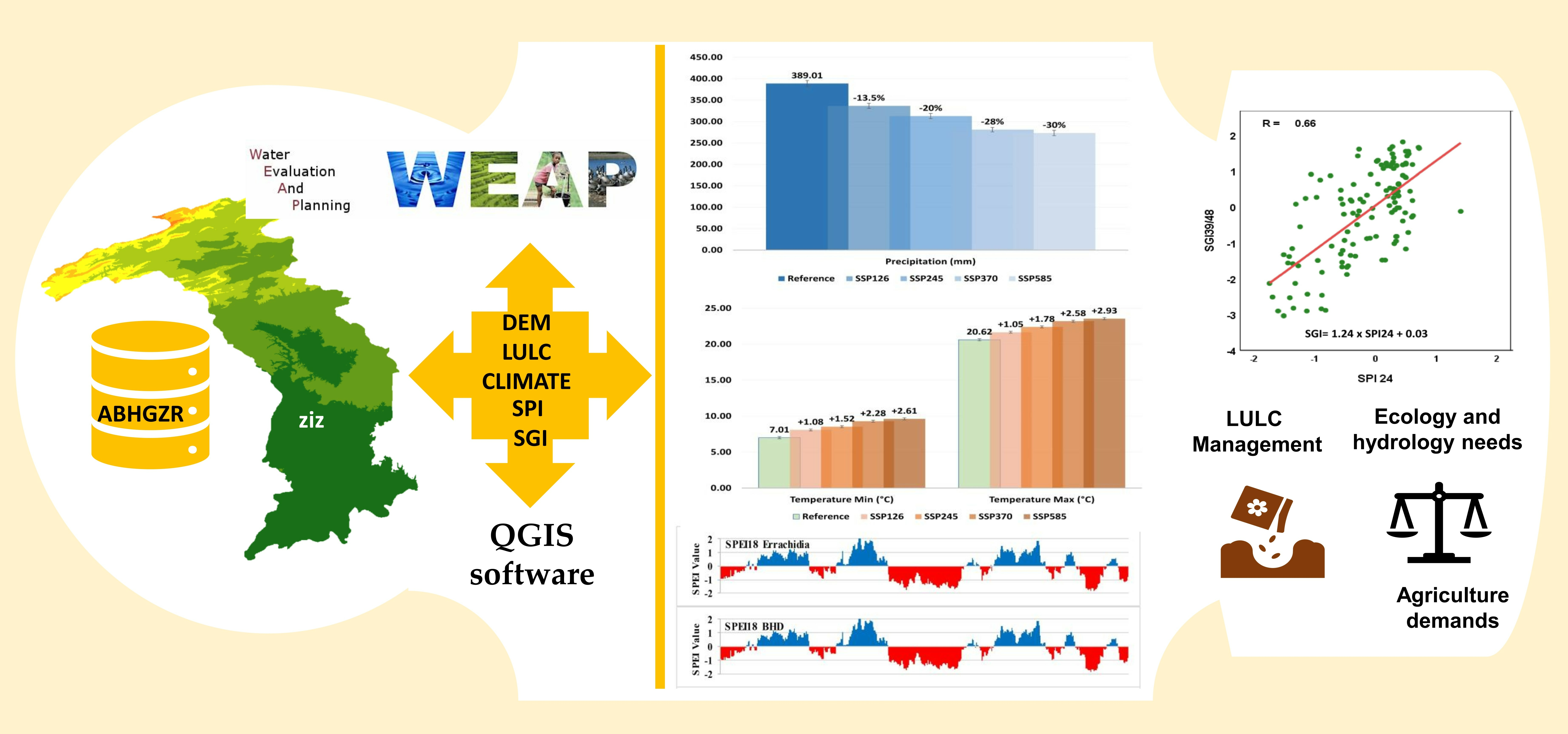
2.2. Data Compilation

To calculate the meteorological drought indices of SPI and SPEI, precipitation data, along with maximum and minimum temperature data, were collected from the MERRA-2 dataset, which is produced by the NASA Global Modeling and Assimilation Office (GMAO), for eight climate stations within the study area. The analysis focused on the pe-riod from 1986 to 2016. For the computation of the SGI, groundwater level observations (piezometric data) from the Guir Rhéris Ziz Water Basin Agency (ABHGRZ) were utilized for the same time frame. The analysis included nine monitoring wells, with three wells located in each of the three zones: the Hassan Addakhil Dam (BHAD), Foum Tillicht, and Radier Erfoud. Climate projections and future meteorological indices were generated using RCM climate data. Additionally, a comprehensive assessment of land use and land cover change was conducted to evaluate its impact on water availability in the watershed.
The data for this assessment was obtained from the delineation mode of the WEAP software (version 2023.0 (Official, non-beta, version)), which incorporates a digital elevation model (DEM), and historical and projected meteorological data including precipitation and temperature were obtained from the CMIP6_MPI-ESM1-2-LR_SSP climate model of the Ziz Basin. The raster map data, covering the years from 1992 to 2020, produced by the European Space Agency (ESA) Climate Change Initiative (CCI), was processed using the QGIS software (version 3.24.0 5) to determine the area of each land cover type at various elevations within the Ziz watershed. The inputs for the WEAP model were used to simulate land class inflows and outflows in the Ziz watershed.
In this study, various data were utilized as inputs for the WEAP model to simulate land class inflows and outflows in the Ziz watershed. These data can be categorized as follows: Firstly, the geographic boundaries of the Ziz watershed, including its components such as the Ziz River (a significant river in Southeast Morocco) and the Hassan Addakhil Dam (HAD) (a crucial unit in the Tafilalet area), were extracted from the delineation mode of the WEAP software. Secondly, historical and projected meteorological data, including that of precipitation and temperature, were obtained from the CMIP6_MPI-ESM1-2-LR_SSP climate model for the study area. Thirdly, evapotranspiration processes, based on land cover and vegetation types, were derived from the same CMIP6_MPI-ESM1-2-LR_SSP climate model. Fourthly, historical streamflow data from four hydroclimate measurement stations within the study area (Foum Tillicht, Foum Zaabel, BHAD, and Radier Erfoud) were acquired from the Ziz Guir Rheris and Maider Water Basin Agency. Lastly, groundwater recharge rates, river flow, and storage coefficients were obtained from the Ziz Guir Rheris and Maider Water Basin Agency as well. A technical flow chart illustrating the study methodology is shown below (Figure 2).

2.3. Calculation of Drought Indices

Drought indices play a crucial role in characterizing various aspects of drought, including its onset and end time, duration, spatial extent, severity, and frequency, at global, regional, and local scales [54].

2.3.1. Standardized Precipitation Index

The Standardized Precipitation Index (SPI) is widely used and recommended as the main meteorological drought index by the World Meteorological Organization (WMO) [55,56,57,58]. The SPI was developed by McKee et al. [25,59], and is known for its effectiveness, flexibility, and standardized nature. It can be calculated at various time scales, ranging from 1 to 48 months [60]. To analyze the impact of rainfall deficiency on drought development in the study area, monthly precipitation data spanning a continuous period of at least 30 years are required [61]. In this study, the cumulative precipitation data from 1986 to 2016 for eight climate stations in the study area were processed, and the SPI index was calculated for the accumulation periods of 1, 3, 6, 9, 12, 18, 24, and 48 months using the R software environment (Rstudio and R version 4.3.1). The precipitation data were fitted to a gamma probability distribution and transformed into a standard normal distribution [25,62]. The probability density function of the gamma distribution is given by the equation:
g x = 1 β α   Γ ( α )   x α 1 e x β   ( x > 0 )
where x (mm) is the amount of precipitation ( X > 0 ) , Γ(α) is the gamma function, α is the shape parameter ( α > 0 ), and β is the scale parameter ( β > 0 ).
McKee et al. [25] have established a classification system for drought based on the Standardized Precipitation Index (SPI). This classification system consists of seven different drought classes, ranging from extremely dry to extremely wet. Table 1 provides an overview of these drought classes.

2.3.2. Standardized Precipitation Evapotranspiration Index

The Standardized Precipitation Evapotranspiration Index (SPEI) provides a more comprehensive measure of drought by incorporating evapotranspiration [24]. The calculation of the SPEI is similar to that of the SPI, but includes the difference between rainfall and potential evapotranspiration (PET) as the input variable. In this study, PET was calculated using the Hargreaves-Samani formula, which is included in the R package Evapotranspiration [63,64]. The difference between precipitation (P) and PET for the given month (i) can be expressed as follows:
Di = Pi − PETi
According to Stagge et al. [62], the values of the Standardized Precipitation Evapotranspiration Index (SPEI) are fitted to a log-logistic probability distribution and then transformed into a normal distribution. Similar to the SPI, the SPEI provides values that represent the severity, intensity, and duration of drought. Negative values of the SPEI indicate dry conditions, which can range from moderate to severe or extreme drought. Positive values, on the other hand, indicate wet conditions, ranging from moderate to severe or extreme wetness.

2.3.3. Standardized Groundwater Index

Understanding and assessing groundwater resources and their vulnerability to climate change is a complex task that requires modeling programs capable of characterizing the subsurface and conceptualizing the aquifer system, including the withdrawal and recharge rates. Numerous studies have been conducted to explore the relationship between groundwater levels and climatic variables, such as precipitation and temperature, using standardized hydrometeorological indices [65].
The Standardized Groundwater Index (SGI) is one such indicator used to quantify the extent of groundwater drought. Its calculation method is conceptually similar to that of standardized indices [66,67]. Monthly mean groundwater level data from observation wells are required as input for the SGI calculation. In this study, the kernel non-parametric distribution [20,68] was utilized to analyze the groundwater data, and a normalization process was applied to derive the SGI. The SGI can range between −3 and 3, where negative values indicate drought conditions and positive values indicate moisture conditions. An SGI value of zero represents an average condition. The SGI serves as a valuable tool for monitoring long-term hydrological conditions and can be employed in groundwater resource management efforts.

2.4. Future Climate Projections and Future SGIs

In arid areas such as the Ziz Basin, the average groundwater level is strongly influenced by the precipitation and potential evapotranspiration (PET). However, the relative importance of these factors varies depending on local conditions such as geology and topography. Precipitation is limited in this basin and serves as the primary source of groundwater recharge, a relationship that has been confirmed in several relevant studies [20,65,69,70,71,72,73,74,75]. Conversely, the PET can be high in arid regions due to elevated temperatures and drought conditions, leading to increased evaporation and transpiration, which can result in a decline in the average groundwater level. Based on this understanding, this section aims to calculate the future SGI using SPI and SPEI values.
In order to obtain future projections of the Standardized Groundwater Index (SGI) for the study area, the relationships between the SPI or SPEI (at different time windows) and SGI over the historical period needed to be examined. A preliminary correlation analysis was conducted using the Pearson correlation coefficient on the indices calculated from 1986 to 2016. A correlation coefficient threshold of 0.6 was adopted to identify an acceptable relationship between the two indices [65]. Once a reasonable correlation was established, a simple linear relationship between the meteorological indices (SPI or SPEI) and the SGI was assumed for the wells with an acceptable correlation. Consequently, the SGI as a function of future meteorological indices (SPI or SPEI) was determined, assuming that the regression equations derived from the historical period would be applicable to the future.

2.5. The Application of the WEAP Model

In this article, the methodology employed relies on the utilization of the WEAP (Water Evaluation And Planning) software tool developed by the Stockholm Environment Institute (SEI) [45]. WEAP is employed for acquiring elevation data and obtaining future climate data (2017–2100) based on the CMIP6_MPI-ESM1-2-LR model, considering the four SSP scenarios (SSP1-2.6, SSP2-4.5, SSP3-7.0, and SSP5-8.5) (Table 2). Additionally, the WEAP was used for calculating land class inflows and outflows. Furthermore, the LULC data were integrated with the powerful WEAP software to conduct a comprehensive evaluation of the water resources associated with each land use class. This coupling allowed for a more robust analysis of the impacts of land cover changes on the water availability and overall water management in the area.

2.5.1. Land Use and Land Cover Change Analysis

Changes in land use and land cover have a significant influence on runoff characteristics and hydrological attributes [77]. These modifications can either augment or diminish water resources, depending on the alterations in landscape, vegetation, and human activities. This study aims to analyze and comprehend the changes in land use and land cover from 1992 to 2020 and assess their impact on water resources in the Ziz watershed. The WEAP software incorporates a feature that enables the automatic delineation of watersheds and rivers using numerical elevation data [78]. It represents land areas based on their elevation and land cover class. The land use and land cover were classified into seven groups: agriculture, urban areas, forest, grassland, shrubland, barren or sparse vegetation, and open water (according to the ESA CCI Land Cover classification). Agriculture encompasses land used for crop cultivation, livestock farming, and other agricultural activities. The forest class represents extensive tree cover and other plant species. Urban areas denote regions with high population density and human-made structures. Grassland refers to areas predominantly covered by grasses and herbaceous plants [79]. Barren or sparse vegetation describes areas with limited plant growth or vegetation cover. Shrubland includes smaller woody plants with multiple permanent stems or short woody plants lacking a single trunk. Open water represents flowing streams, small reservoirs, and dams [80].

2.5.2. Future Land Class Inflows and Outflows

Arid regions are particularly susceptible to the impacts of climate change, including shifts in rainfall patterns and rising temperatures. In order to effectively adapt to and mitigate the impacts of climate change, it is essential to comprehend the influence of these changes on surface water and groundwater resources. Surface water and groundwater are interconnected elements of a unified water system [81]. An overextraction of groundwater frequently leads to a reduction in river water levels [82]. Similarly, the extensive withdrawal of surface water can result in a lowering of the groundwater table.
To assess these water resources within a watershed, the utilization of the WEAP models is instrumental. These models simulate natural hydrological processes such as precipitation, evapotranspiration, and infiltration, allowing for a comprehensive analysis. Calculating land class inflows and outflows is achieved by inputting relevant data into the WEAP framework. In this study, scenarios based on the Shared Socioeconomic Pathways (SSP) were employed to project anticipated changes in land class inflows and outflows. These scenarios provide insights into potential future trends and facilitate the understanding of the impacts on water resources.

3. Results

3.1. Meteorological Drought Index

This section presents the analysis results of drought indices SPI24-48 and SPEI18-48. The selection of these specific timescales was based on previous research findings. Leelaruban et al. [71] identified a significant correlation between SPI24 and the Standardized Groundwater Index (SGI). Secci et al. [65] reported a strong correlation between the SPI–SPEI and SGI at shorter timeframes. Additionally, Kumar et al. [70] found that a variable precipitation accumulation period of 3–24 months is necessary to align the SPI and SGI temporally. By considering these findings, this analysis provides insights into the correlations between drought indices and groundwater conditions at various timescales, both locally and regionally.
According to the SPI results shown in Figure 3, there is general agreement among stations during major events within the 24- to 48-month accumulation periods, although some differences are observed in certain years. Within the 48-month timeframe, there were successive periods of drought and wetness observed. The first drought episode occurred from 1986 to 1989, followed by another significant and prolonged drought from 2000 to 2006, with varying severity from year to year. The lowest SPI values were observed in 1986 and 2002–2003 across all stations, indicating severe drought conditions (SPI < −1). Furthermore, the study period witnessed the occurrence of drought years, with a notable concentration in 2014, towards the end of the period. During the periods of 1996–1999 and 2007–2012, moderately wet to very wet years were experienced. The highest SPI values were recorded in 2009–2010 at Taouz and Radier Erfoud, ranging from 1.8 to 2.
Analyzing the results based on the 48-month time window for the SPEI, as shown in Figure 3, it is evident that all stations experienced a drought period starting in 1986, although the end of this period varied across stations. Three stations (Foum Tilicht, M’Zizel, and Zaouit Sidi Hamza) saw the end of the drought in 1989, while four stations (BHD, Errachidia, Foum Zaabel, and Radier Erfoud) experienced the end in 1988. The second drought period occurred from 2000 to 2006 at all stations. It is noteworthy to mention the occurrence of drought during the latter years of the study period, specifically between 2013 and 2016. The lowest SPEI values were obtained in 1986 at all stations except Taouz, and in 2002–2003 across all stations, indicating severe drought conditions (SPEI < −1.5). Nevertheless, the periods of 1990–1999 and 2007–2012 were characterized by a wet climate, although a few years within the first period showed negative SPEI values in three stations. The highest SPEI values were recorded in 2009–2010 at Taouz and Radier Erfoud. These findings provide an overview of the drought and wet periods observed in the region based on both the SPI and SPEI calculations, and by calculating the mean values of these indices for different time intervals, researchers or analysts can identify long-term patterns, such as periods of drought or excessive precipitation, and assess the variability in precipitation conditions over the years. Further analysis and discussion on the correlations between the meteorological and groundwater indices will be presented later in the study.

3.2. Groundwater Drought Index

The groundwater drought analysis was conducted using the Standardized Groundwater Index (SGI) based on data collected from monitoring wells spanning the period from 1986 to 2016. The SGI results, as depicted in Figure 4, reveal two distinct drought periods that align with the findings of the SPI and SPEI analyses. Notably, the drought period from 1986 to 1989 affected all wells in Radier Erfoud, two wells in BHD (SGI ≤ −2), and the well 597/39 in Foum Tillich (SGI ≤ −3). Similarly, the drought period from 2000 to 2006 was evident in five wells (SGI < −2), despite the presence of missing data for certain years. A third episode of drought appeared at the end of the study period during the years 2012–2016 for wells 599/39 and 592/39, as well as in the year 2014 for the remaining wells. These findings highlight the occurrence of drought events in the groundwater system, with specific emphasis on the notable drought periods from 1986 to 1989 and 2000 to 2006. Additionally, a dry period was observed towards the end of the study period, as indicated by the SGI values for the respective wells.

3.3. Relationships between Meteorological and Groundwater Drought Indices

To examine the relationship between meteorological and groundwater droughts, the Pearson correlation coefficient was employed, which is a widely used method in various studies worldwide. The analysis considered eight different time scales (1, 3, 6, 9, 12, 18, 24, and 48 months) to assess the correlations.
Table 3 presents the Pearson correlation results between the Standardized Groundwater Index (SGI) and other drought indices. The correlation analysis was conducted without considering any time lag between the meteorological and groundwater drought indices. In this table, correlations equal to or greater than 0.5 are considered moderate, while correlations equal to or greater than 0.7 are classified as strong. Generally, the Standardized Precipitation Index (SPI) exhibits moderate correlations with the SGI for accumulation periods ranging from 18 to 48 months. Similarly, the Standardized Precipitation Evapotranspiration Index (SPEI) demonstrates moderate correlations with the SGI for accumulation periods of 12 to 48 months, particularly in the monitoring wells of the Errachidia zone. However, the other wells in the remaining two zones show relatively low correlations, except for well 525/57, which exhibits a good correlation in the 48-month accumulation period. The strongest correlations were observed between SPI 48 and 525/57 at Sifa Oulad Zahra, as well as between SPEI 18 and 24 with 29/48 at Tazouka and 39/48 at Tighiwrine.
The relationships between the SPI–SGI and SPEI–SGI vary across observation wells for accumulation periods ranging from 1 to 9 months. In some wells, the relationships are weak, while in others they exhibit negative correlations. The correlation coefficients between SPI/SPEI and SGI at these time scales are typically below 0.5, which may indicate the influence of other parameters, such as geological characteristics, on the redistribution of monthly atmospheric water volume within the underground. On the other hand, longer accumulation periods provide a better understanding of the cumulative impact of climate conditions on groundwater.
In essence, climatological drought serves as a precursor to hydrological drought [83], making it a critical factor for understanding and managing water resource challenges during periods of reduced precipitation and prolonged dry conditions. Recognizing this relationship is crucial for effective drought monitoring and mitigation efforts.
After analyzing the correlation between the SPI and SGI, we proceeded to examine their relationship using a linear regression analysis. The accumulation periods of 24 and 48 months were selected due to the highest correlations being observed between SPI and SGI in Tazouka 29/48, Tighiwrine 39/48, Sifa Oulad Zahra 525/57, and Oulad Talb 448/57, with correlation coefficients exceeding the threshold of 0.6 (Table 3). In these wells, the slope of the regression line consistently remains below one (Figure 5). This suggests the presence of an attenuation mechanism within the study area, indicating that the groundwater system exhibits a resilience or buffering capacity against rapid and severe responses to precipitation deficits [66].
The results of the correlation analysis between the SPI and groundwater levels index (SGI) at different monitoring stations in the region are consistent with previous studies that have shown a significant relationship between precipitation patterns and groundwater recharge. According to Srinivasan et al. [84], the SPI has been widely used as a tool for drought monitoring and prediction and is a reliable indicator of groundwater recharge in arid and semi-arid regions. Similarly, Zhang et al. [85] reported significant correlations between the groundwater levels and SPI at different time scales in the North China Plain, with longer-term SPI values having a stronger influence on groundwater levels than shorter-term values.
In the analysis of the relationship between the Standardized Precipitation Evapotranspiration Index (SPEI) and the Standardized Groundwater Index (SGI) using linear regression, significant correlations are observed for the accumulation periods of 18, 24, and 48 months, surpassing the threshold correlation coefficient of 0.6. This is particularly evident in the wells of Tazouka 29/48, Tighiwrine 39/48, and Mouch Kalal 1208/48, with correlation coefficients of 0.73, 0.74, and 0.64, respectively, for SPEI 18 with coefficients of 0.75, 0.77, and 0.70, respectively, for SPEI 24, and a coefficient of 0.6 for SPEI 48, as indicated in Table 3. For these wells, the slope of the regression line consistently remains below one, as depicted in Figure 6. The spread around the regression line suggests that factors other than useful precipitation also influence groundwater levels. However, due to the moderate correlation between the SPEI and SGI, this straightforward relationship can still be utilized for further analysis.
It is important to acknowledge that the relationship between precipitation, evapotranspiration, and groundwater levels can be intricate and influenced by various factors, including geology, soil properties, land use, and groundwater recharge rates. Furthermore, there are distinctions among the different drought indices in terms of drought intensity and duration. The SPI and SPEI are primarily based on precipitation and evapotranspiration, while the SGI incorporates subsoil properties, such as infiltration and geological variables, in addition to precipitation [34]. Therefore, it is crucial to consider these factors when interpreting drought analysis results and formulating effective management strategies for groundwater resources.

3.4. Future Climate Projections and Future Meteorological Indices

The future climate projections for the study area were obtained using the CMIP6_MPI-ESM1-2-LR model. These projections offer valuable insights into the anticipated climate conditions over the study area for the next periods under various Shared Socioeconomic Pathways (SSP) scenarios. Figure 7 visually presents the projected changes in important climate variables, specifically those of precipitation and temperature.
The analysis of precipitation scenarios for the period of 2017–2100, compared to the reference years (1986–2016), reveals a decrease in the percentage of precipitation. The optimistic SSP1-2.6 scenario shows a decrease of −13.5%, while the pessimistic SSP5-8.5 scenario indicates a decrease of up to −30% (Figure 7A). Additionally, the scenario analysis of minimum and maximum temperatures in the study area, compared to the reference years, shows an increase in minimum temperature. The SSP1-2.6 scenario predicts a minimum temperature increase of 0.8 °C, while the SSP5-8.5 scenario projects a greater increase of 2.61 °C. Regarding maximum temperature, the SSP1-2.6 scenario indicates a 1.5 °C increase compared to the reference years, while the SSP5-8.5 scenario suggests a larger increase of 2.93 °C (Figure 7B). These findings are consistent with studies conducted by the Directorate General of Meteorology, which predict a warming of 2 to 3 degrees in the southeast region of the country by 2050 under the RCP8.5 scenario [15]. Considering these projected climate changes, it is possible to assess their impact on future meteorological indices. These indices, derived from the climate model outputs, are used to determine the future groundwater index, providing insights into potential changes in groundwater availability.

3.5. Future Standardized Groundwater Index

Based on the analysis of the SGI–SPI and SGI–SPEI relationships using linear regression analysis (Section 3.3), specific wells and accumulation periods were selected based on their strong correlation (correlation coefficient exceeding the threshold of 0.6). These wells, including Tazouka 29/48 and Tighiwrine 39/48 for SPI24, Sifa Oulad Zahra 525/57 and Oulad Talb 448/57 for SPI48, as well as Tazouka 29/48, Tighiwrine 39/48, and Mouch Kalal 1208/48 for SPEI18, 24, and 48, were used to create future SGI values based on future SPIs and SPEIs.
After calculating the future meteorological indices from the regional climate model (RCM) data, the SPI and SPEI values obtained from the climate models at each station location were averaged across the Ziz basin for each SSP scenario. Using the relationships depicted in Figure 5 and Figure 6, the SGI values for future periods (2017–2100) were estimated.
The results of the SGIs based on the meteorological indices indicate that the wells in each regression relationship exhibited similar trends over the years and across each SSP scenario. Therefore, the results of the SGI–SPI24 and SGI–SPEI18 for Tighiwrine 39/48 were chosen as representative illustrations for the other wells. The summarized results for this well can be seen in Figure 8 using boxplots.
According to the SGI–SPI24 regression relationships, significant changes were observed between the historical and future periods across the four scenarios. In the short and medium term, there was a significant decrease in median SGI values, indicating a negative trend compared to the reference median value. However, under SSP126, the median SGI value increased in the long term. In contrast, under SSP245 and SSP585, there was an increase in SGI value in the short term compared to the historical period, with values close to zero in the medium term. Conversely, a reduction in SGIs was observed in the long term under the same scenarios. The SSP370 scenario displayed median values that closely aligned with those of the reference period in the short and medium term but dropped below zero in the long term.
For the SGI–SPEI18 regression relationships, the median SGI value decreased in the short and medium term, taking on negative values compared to the median reference value. However, under SSP125 and SSP245, the median SGI value increased in the long term. Under SSP370 and SSP585, there was an increase in the SGI in the short term compared to the reference period, with values close to the reference in the medium term. However, under the same scenarios, the SGI value reached −1 in the long term.
Numerous studies have provided evidence that Morocco is expected to face dry years and a precipitation deficit as a result of climate change [86,87]. Considering the findings of this analysis, it is highly probable that the future of water resources in this oasis will be greatly compromised. These simulations can help in assessing potential changes in drought or wet conditions in our study area and provide insights into potential changes in groundwater availability in response to the changing climatic conditions.

3.6. Land Use and Land Cover Changes and Elevations

The Ziz basin is a geographic region with an area of 1,400,890 hectares and an elevation ranging from 615 to 3675 m, with a mean elevation of 1210 m (Figure 9). The basin is characterized by a diverse range of elevations, with most of the catchment area falling between 500 to 1500 m. The results showed that 42.42% of the catchment area falls between 500 to 1000 m, while 32.26% falls between 1001 to 1500 m. The elevation range of 1501 to 2000 m makes up 16.31% of the area, while the remaining elevation ranges of 2001 to 4000 m contribute to less than 10% of the total catchment.
These statistics suggest that the Ziz watershed is a region with a predominantly low- to mid-elevation range, with a smaller portion of the catchment area characterized by higher elevations. The distribution of elevation ranges within the catchment area is important to consider when assessing the region’s ecological and hydrological processes, as different elevations may be associated with distinct vegetation types, precipitation patterns, and runoff characteristics. The land cover information is presented in terms of the different land cover types, their area in hectares, and percentages of the total catchment area (Table 4).
The findings showed that most of the catchment area is covered by barren or sparse vegetation, accounting for 81.82% of the total area (Table 4). Agriculture is the next largest land cover type, covering 2.75% of the catchment area, followed by urban areas, shrubland, forest, grassland, and open water, which have much smaller coverage percentages. The dominance of the sparse vegetation is likely due to the arid and semi-arid climate, which limits the growth of vegetation. The presence of agriculture is likely associated with irrigation practices, which are necessary for sustaining crop growth. The small coverage percentages of forest, grassland, urban, shrubland, and open water suggest that these land cover types are relatively rare in the catchment area. The presence of forest and grassland may be associated with areas with higher elevations or more favorable conditions for vegetation growth. The presence of urban areas may be associated with population centers or economic activity, while the presence of open water may be associated primarily with reservoirs. The land cover information can be useful for understanding the spatial distribution of different land cover types in the study area and their potential impact on hydrological processes. For example, areas with barren or sparse vegetation may have higher rates of runoff and erosion than areas with vegetation cover. Urban areas may have higher rates of impervious surfaces, leading to increased surface runoff and decreased infiltration.
The land use and land cover changes between 1992 and 2020 are summarized in Table 5, and the corresponding visual representation is in Figure 10.
Table 5 represents the land use and land cover transition matrix in the Ziz basin, covering the period from 1992 to 2020 (data acquisition period for land use). According to the matrix, the percentage of agricultural land increased from 7.46% to 13.33% in 2020 (a gain of over 5%). The zone with the largest agricultural land is the downstream zone of the B.H.AD at altitudes of 1001 to 1500 m. Despite the relative drying up of the dam, this zone remains in a favorable position, with water consumption reaching about 12,400 m3/ha, the highest water consumption in the valley [88]. The Haut-Ziz zone, upstream of the dam in altitudes of 1501 to 2000 m, is the second zone in terms of agricultural land. However, this zone has experienced an increase in agricultural land since 2003. This latter zone draws its water resources from the groundwater through individual motor pumps, as precipitation mainly falls as snow on the high reliefs of the North and West, with relatively short durations due to high sunlight on the high reliefs. The barren or sparse vegetation class experienced a decrease of 5% (from 90.80% in 1992 to 85.67% in 2020). The decrease in barren or sparse land area at the altitude range of 1501–2000 m may be due to vegetation regrowth and natural land restoration processes, or to human interventions, such as reforestation and conservation efforts. The forest area showed a very slight increase of 0.01%. Grassland transitioned from 0.25% to only 0.02%, and is mainly located in the northern part of the basin, at altitudes between 1501 m and 3000 m, and provides important resources for local communities, such as grazing lands for livestock. However, overgrazing and other human activities can lead to the degradation of grasslands, reducing their productivity and resilience [89]. Grasslands can affect the water cycle, as they act as a type of land cover that can affect rainwater infiltration, surface runoff, and groundwater recharge [23]. Urban land is located in the lower and middle zones at altitudes of 500–1500 m, and it witnessed a significant increase from 0.45% in 1992 to 0.68% in 2020. The expansion of urban areas has significant environmental impacts, including habitat fragmentation, and an increased demand for resources, such as water and energy. The other two classes, open water and shrubland, remained unchanged during the study period. The largest area of shrublands, covering 1247 hectares, is located at altitudes between 2001 and 2500 m. The change in the surface area of this type of vegetation cover is much less significant than that of the previous categories.
These land use and land cover changes are closely related to climate change and anthropogenic activities such as excessive groundwater extraction, which is the primary source for irrigation and drinking water supply in arid areas. In fact, Figure 10 illustrates the spatial distribution of areas that have undergone changes, particularly towards agricultural land. These areas are located along the banks of the Ziz River, where a high number of wells have been dug by the local population to access drinking water and irrigate cultivated areas (oases). Starting from 2008, with the implementation of the Morocco Green Plan, local farmers and agricultural investors were granted extensions of land (thousands of hectares), which explains the decline in groundwater levels in most monitored wells by the Rheris-Guir-Ziz Hydraulic Basin Agency, and in personal wells of the local population.

3.7. Impact of LULC on Surface Runoff and Groundwater Flow

According to the findings presented in Table 5, the expansion of agricultural land can be attributed to the conversion of both barren or sparse vegetation and grassland into agricultural areas. These changes in land use and land cover have significant implications for drought assessment. The application of the WEAP (Water Evaluation and Planning) model to evaluate the impact of land use and land cover (LULC) on surface runoff and groundwater flow in the Ziz watershed is essential. Agriculture typically demands substantial water resources for irrigation, and even a relatively small increase in agricultural land can lead to a noticeable surge in the water demand. This is particularly critical as water resources are already strained during drought conditions, and any additional demand can worsen water scarcity. Therefore, the WEAP model must consider the increased water demand for agriculture. Furthermore, with expanded agricultural land, higher evapotranspiration rates can deplete soil moisture and reduce groundwater levels during dry periods. Consequently, the region becomes more vulnerable to drought conditions, potentially resulting in more severe consequences.
To study the impact of land use types on water resources, calculations of surface runoff and groundwater flow were conducted at the 1001 m and 1500 m altitude fields. This specific area was selected because it includes wells that exhibited a strong correlation between meteorological drought indices and the SGI. It is important to note that this zone encompasses five different land use classes. Future scenarios of surface runoff and groundwater flow quantity were created for each land use class by comparing them to the reference period. The results of these comparisons are depicted in Figure 11.
Findings show that the amount of surface water and groundwater in agricultural land will increase in the coming years in the short term compared to the previous period in agricultural land, barren or sparse vegetation land, urban areas, and open water areas, but will decrease in the medium and long term in these lands. Water resources in shrubland are too low and show no change over time.
The largest quantity of surface runoff and groundwater flow is found in barren or sparse vegetation land. This class has a high potential for increased surface runoff. Without vegetation to absorb and slow the movement of rainwater, precipitation can quickly flow over the land surface, leading to higher runoff rates. The absence of vegetation also means that there are no roots to create pathways for water to penetrate the soil and recharge the groundwater. This reduced infiltration can result in more water flowing to the surface and less being absorbed by the soil.
The second class which shows a high quantity of surface runoff is agricultural land, and this can lead to increased surface runoff due to deforestation, soil compaction, and excessive irrigation. The result is a drop in groundwater levels, which can affect the sustainability of water resources.
Urban lands have the same impact on water resources, as these areas generally have large impermeable surfaces, which do not allow water to infiltrate into the ground. Open water in the Ziz watershed is rare, so the quantity of surface runoff and groundwater flow is also rare in this land class. Open water can contribute to groundwater recharge. Water from these lands can percolate into the ground and recharge aquifers. This helps maintain or increase groundwater levels, making open water bodies a valuable source of groundwater recharge. Shrublands can reduce surface runoff compared to barren lands and urban landscapes. The presence of shrubs slows and absorbs rainfall, allowing more water to infiltrate into the soil, thereby reducing the amount and rate of surface runoff.

3.8. Future Scenarios of Land Class Inflow and Outflow in Ziz Watershed

The results obtained from the WEAP simulation of hydroclimatic data in the Ziz watershed provide insights into the future changes in land class inflows and outflows. Figure 12a–e shows land class inflows and outflows in million cubic meters on annual or monthly average bases for the agriculture land class under different climate change scenarios. Across all scenarios, the key trends observed are decreases in the snowmelt/snowfall and soil moisture, contributing to reduced water storage. Substantial volumes are lost to evapotranspiration each year. Some water flows into groundwater reserves or is extracted for irrigation, while the rest is lost through surface runoff or percolation between soil layers. The magnitude and proportions of these inflows and outflows vary significantly depending on the emission scenario. Under lower emission scenarios like those of SSP1-2.6 and SSP2-4.5 (Figure 12b,c), annual snow melt/snowfall decreases range from 3–4 million m3, accounting for 0.7–0.8% of total precipitation. Soil moisture decreases by 255–286 million m3, which represents 55–56% of precipitation. Higher emission scenarios lead to much greater impacts. Under SSP5-8.5 (Figure 12e), annual snowmelt decreases are over 114 million m3 or 21% of precipitation, while soil moisture decreases are 153 million m3 or 28% of precipitation. Across all scenarios, evapotranspiration is the dominant outflow pathway, removing 487–557 million m3 or 96–102% of annual precipitation. Groundwater recharge and irrigation extractions generally account for 1–7% of precipitation. Table 6 presents the changes (Δ) in each parameter for the SSP1-2.6, SSP2-4.5, SSP3-7.0, and SSP5-8.5 scenarios compared to the reference scenario. The values are indicated in million cubic meters (M m3) and percentages (%), reflecting the differences in each scenario.
The results provide insight into changing hydrological dynamics under climate change to support water resource management in the study region.

4. Discussion

4.1. Drought Evolution in Ziz Watershed

The results of this study have significant implications for water management in the region, particularly during periods of drought. The utilization of drought indices such as the SPI, SPEI, and SGI can assist water managers in identifying drought-prone areas and developing appropriate strategies for mitigation. Additionally, Zhang et al. [85] suggested that SPI-based groundwater recharge models can enhance water management strategies in regions where groundwater serves as a primary water source.
Based on the SPI and SPEI results, the study area has experienced varying severities and durations of drought periods at each station. The driest years across all stations were 1986–1989 and 2000–2006, while the wettest years were 1996–1997 and 2007–2012. The SGI analysis reveals similar drought periods, with the addition of a dry period observed at the end of the study period from 2013–2016 for wells Kerrandou 599/39 and Ait Ousoumor 592/39, and in the year 2014 for the rest of the wells. These findings align with previous studies conducted in Morocco and the Tafilalet region. Research by Dafouf et al. [90] also indicated that 1986 and 2000–2001 were characterized by dry and severely dry conditions at all stations within the Ziz Basin, while 2008–2011 exhibited wet and extremely wet conditions. These findings are supported by the study conducted by Mahdaoui et al. [18] on drought characteristics in the Ziz basin. According to the reports from the Regional Office for Agricultural Development of Tafilalet (ORMVATF), the inflow to the Hassan Addakhil Dam in recent years showed low levels during 1986, 2000–2001, and 2013, while higher levels were recorded during 1996 and 2008–2010. The report also highlighted the 2009–2010 season as one of the most favorable for the Hassan Addakhil Dam in terms of recorded inflows, with a volume of 139 M m3. Ezzine et al. [91] revealed that Morocco experienced moderate droughts in the late 1990s until 2001, while 2008–2011 were characterized by wet and extremely wet conditions. This indicates that the drought and wet conditions observed in the Ziz Basin were generally consistent with conditions across Morocco.
The dependence on groundwater resources and the lack of precipitation contribute to a decrease in piezometric levels, as demonstrated by the results of this study. Consequently, the study area experienced the drying up of wells and Khettaras, and the number of wells decreased by half [19]. Additionally, due to drought in recent years, the Hassan Addakhil Dam in the Ziz Basin has experienced a year-over-year decline [92,93].
Regarding the correlation analysis between the SPI, SPEI, and SGI, the results indicate that the SPI exhibits a good correlation with the SGI for accumulation periods of 18–48 months. This finding is consistent with the study by [75], which confirmed that the 48-month accumulation period showed the highest correlation between the two indices.The SPEI displays a good correlation with the SGI for accumulation periods of 12–48 months. The strongest correlation was observed for SPI 24 and 48 at Tighiwrine 39/48 and Sifa Oulad Zahra 525/57, respectively, and for SPEI 18 and 24 at Tazouka 29/48 and Tighiwrine 39/48, respectively. Finally, SPEI 48 at Sifa Oulad Zahra 525/57 also exhibited a strong correlation. These results align with several studies, including the research presented by [75], which confirmed that meteorological drought indices (SPI, SPEI) displayed the strongest correlation with the groundwater drought index. Other studies by [65,73,94] have also shown high correlation coefficients between these indices, indicating a clear influence of antecedent precipitation or useful antecedent precipitation on groundwater indices. The correlation between the SPI–SGI and SPEI–SGI for accumulation periods ranging from 1 to 9 months is generally weak and occasionally negative in certain observation wells. On the other hand, longer accumulation periods provide a more thorough insight into the cumulative effects of climate conditions on groundwater. This study’s area depends on rainfall in upstream zones (in our case, in the Upper Atlas zone). The water supply in this zone is stored in the Hassan Addakhil dam and temporarily released into the middle and lower Ziz valley zones to irrigate the oases (desert agro-ecosystem). This may explain why most of the wells showing a relationship between the SPI/SPEI and SGI are located in the Errachidia region, while the other two zones show a weak correlation between precipitation and groundwater.
The vulnerability analysis conducted by the Ministry of Energy, Mines, and the Environment [95] revealed that the impact of climate change is estimated to result in a 25% reduction in water resources, including the effects of droughts experienced in Morocco since the 1980s. Droughts and precipitation levels below 100 mm are characteristic of Southern and Southeastern Morocco [96]. Given the vulnerability of water resources in the Tafilalet region and the projected water deficit for irrigation, which is expected to reach −419 million m3 by 2030 [50], the vision of the state is to enhance, improve, and develop the phoeniciculture sector by producing high-quality varieties in response to national and international demand. This necessitates the development of plans and policies to enhance the adaptive capacity of the southeastern oases of Morocco.

4.2. Land Use and Land Cover Change in the Ziz Watershed

Land use and land cover change is a major driver of environmental change in many regions around the world. The Ziz watershed has undergone significant changes in land use/cover over the past few decades, with implications for the region’s ecology, hydrology, and socioeconomic development. This article reviews the current state of knowledge about land use change in the Ziz watershed and discusses the implications of these changes for the region’s sustainability and resilience.
The Ziz watershed is an arid and semi-arid region, with a hot and dry climate and limited rainfall. Historically, the region was characterized by pastoralism and rainfed agriculture, with small-scale irrigation systems developed along the river’s course. However, since the 1960s, the region has undergone significant changes in land use, with a shift towards large-scale irrigated agriculture, particularly the cultivation of date palms. This shift has been driven by government policies to promote agricultural development and has been facilitated by the construction of large-scale dams and irrigation systems. The findings of this study show that the Ziz watershed saw an increase of 5% in agricultural land, which can exert considerable pressure on surface and groundwater resources. These are also the findings of a study conducted by [97]. The expansion of irrigated agriculture has had significant impacts on the region’s ecology and hydrology. The conversion of natural vegetation to cropland has reduced the region’s biodiversity, and increased soil erosion and sedimentation in the river. Further, the construction of dams has also disrupted the natural flow of the river, leading to changes in water quality and quantity, and the displacement of communities living along the river’s course.
The barren or sparse vegetation class experienced a decrease of 5% during the study period. In this type of land, surface runoff becomes more significant and groundwater flow gets weaker [98]. The Grassland category, which represents natural grassy areas, showed a decrease in surface area by 22%. Grasslands are important ecosystems that provide important ecological functions, such as soil conservation, carbon sequestration, and biodiversity conservation [99]. The presence of grasslands helps reduce soil erosion and promotes groundwater recharge, which is important for maintaining water availability [100]. The decrease in the surface area of the grassland category in the Ziz basin can be attributed to overgrazing, which is the most significant threat to natural grasslands in the region [101]. The high density of livestock in the upper Ziz communities has led to the progressive degradation of natural grasslands and the exhaustion of edible grass species [101]. This can lead to a loss of soil fertility, increased soil erosion, and the loss of vegetation cover.
As for the urban area, the results of this study revealed an increase of 0.22 in this class of land, and a study by [102] showed an increasing trend in urban areas in the Errachidia province during the period of 2005–2020. This increase in urban land reflects the population growth and development of infrastructure in the region. According to projections made by the Moroccan Urbanism Department, the Ziz Valley is expected to experience an increase of nearly 93,000 inhabitants between 2004 and 2029, corresponding to an average population growth rate of +0.92% [103]. Xu et al. stated that agricultural activities, domestic water supply, and urban expansion can affect the propagation time of meteorological and hydrological droughts [104]. Urbanization can contribute to climate change through the emission of greenhouse gases from transportation, buildings, and industry. The shrublands class remained unchanged during the study period according to the findings of this study. They are an important ecosystem that provides various ecological functions, such as soil conservation, carbon sequestration, and biodiversity conservation [105]. They also provide important resources for local communities, such as fuelwood, medicinal plants, and grazing lands for livestock [106]. The stability of the shrubland category in the Ziz basin over time may be attributed to the relatively stable climatic and environmental conditions at higher altitudes, which are more favorable for vegetation growth and development. However, the shrubland category is also vulnerable to land degradation and desertification due to overgrazing, deforestation, and other human activities that can lead to soil erosion and the loss of vegetation cover [107].
Open water bodies are an important class that provides various ecological functions, such as water storage, habitats for aquatic species, and flood control. They also provide important resources for local communities, such as water for irrigation and domestic use [108]. These water bodies are important for local communities and support a wide range of aquatic and terrestrial species [109].
The stability of the open water category in the Ziz basin over time can be attributed to the natural characteristics of the water bodies, which are relatively resistant to changes in land use and climate. The water bodies in the study area are rare and the estimated change is slight since the area is arid, as mentioned by [102]. However, open water bodies in the region are also vulnerable to pollution, over-extraction, and other human activities that can lead to water quality degradation and the loss of biodiversity [110]. In the Ziz basin, the open water bodies are mainly composed of rivers and streams, including the Hassan Addakhil Dam, as well as the Ramsar sites of the Tafilalet oasis [111].
In arid and semi-arid regions, forests are particularly important for their role in regulating water resources, reducing soil erosion, and contributing to the infiltration of precipitation into deep aquifers, thereby increasing groundwater flow, and they can act as a source of evapotranspiration. This process affects the overall water balance in a watershed. The forest area showed a very slight increase of 0.01% in the Ziz watershed between 1992–2020. The expansion of forest land can be explained by the resistance of some species of trees to drought and high temperatures [112]. However, forests in the region are also vulnerable to degradation and deforestation due to human activities, such as overgrazing, logging, and land conversion for agriculture and urbanization [113].
To address these challenges, there is a need for integrated land use planning that balances the demands of agriculture with the need to protect the region’s ecology and hydrology. This requires a participatory approach that engages all stakeholders, particularly the small-scale farmers and pastoralists who are often marginalized in decision-making processes. It also requires the development of alternative livelihoods, particularly in sectors such as tourism and renewable energy, that can provide sustainable economic opportunities for communities in the region.
The land use change in the Ziz River basin has significant consequences for the environment and the people living in the area. The causes of land use change include agricultural expansion, urbanization, tourism development, and the increase in the demand for wood and charcoal. The consequences of land use change include the loss of natural habitats, soil erosion, and increased pollution. The future implications of land use change include climate change, water scarcity, and reduced soil productivity. The implementation of sustainable land use practices is necessary to mitigate these effects and ensure a better future for the Ziz River basin.

4.3. Climate Change Scenarios Adapted to the Moroccan Context and Arid and Saharan Zones

Climate change is a global phenomenon that has already had a significant impact on various sectors, including agriculture, water resources, and human health. The situation is particularly challenging in Morocco, a country that is already prone to droughts and water scarcity. Therefore, it is essential to develop climate change scenarios that are specific to the Moroccan context and are adapted to its arid and Saharan zones. The Moroccan government has been actively involved in climate change adaptation efforts and has developed a national strategy to mitigate the impacts of climate change, which includes the identification of priority sectors, such as water resources, agriculture, and health, and the development of adaptation measures specific to each sector. One of the most critical steps in climate change adaptation is the development of climate change scenarios that can provide information on possible future climate conditions. These scenarios are developed based on climate models that simulate how the climate will change in response to various factors, such as greenhouse gas emissions. Several studies have developed climate change scenarios for Morocco, considering the specificities of the country’s climate and geography [114,115,116].
According to the study by [117], the CMIP6_MPI-ESM1-2-LR_SSP model has shown improvements in simulating key climate features such as the global temperature, sea level rise, and extreme events compared to its predecessors, the CMIP5 models. It has been used also in various studies, such as that of the assessment of future water availability in the Nile River basin under different climate scenarios [118] and the projection of future precipitation changes in the Sahel region [119]. These studies demonstrate the potential of the CMIP6_MPI-ESM1-2-LR_SSP model for informing decision-making processes and developing climate adaptation strategies. This model is a state-of-the-art global climate model that can provide useful insights into the climate change projections for Morocco. It considers a wide range of factors such as the atmospheric carbon dioxide concentration, land use change, and anthropogenic emissions to simulate future climate scenarios. One of the key strengths of this model is its ability to provide information on regional climate patterns, which is essential for countries like Morocco that are highly vulnerable to climate change. The CMIP6_MPI-ESM1-2-LR_SSP model is designed to provide climate projections for the North African region, including Morocco. It has been validated for the region, and the results show good agreement with observed data. The model has been used to project future climate conditions in Morocco under different scenarios.
According to the CMIP6_MPI-ESM1-2-LR_SSP model, the temperature in Morocco is projected to increase in the future, with the magnitude of the increase depending on the scenario. Under the SSP1-2.6 scenario, the temperature is projected to increase by 1.1 °C by the mid-century (2041–2060) and by 2.2 °C by the end of the century (2081–2100), relative to the reference period (1986–2005). Under the SSP5-8.5 scenario, the temperature is projected to increase by 2.5 °C by mid-century and by 5.5 °C by the end of the century. The model also projects changes in precipitation in Morocco. Under the SSP1-2.6 scenario, there is a slight increase in precipitation in some parts of Morocco, while other areas experience a decrease in precipitation. Under the SSP5-8.5 scenario, most parts of Morocco are projected to experience a decrease in precipitation.
To develop effective adaptation measures, it is essential to consider not only the projected changes in temperature and precipitation but also their impacts on various sectors. For example, in the agriculture sector, changes in temperature and precipitation can affect crop yields, soil moisture, and pest and disease dynamics. Therefore, adaptation measures such as crop diversification, water-efficient irrigation systems, and pest management strategies need to be developed and implemented.
In conclusion, climate change is a significant challenge for Morocco, particularly in its arid and Saharan zones. Climate change scenarios are essential for developing effective adaptation measures and should be used to inform decision-making processes and guide the development of sector-specific adaptation measures.

4.4. Future Climate Projections and Future Water Availability in the Ziz Watershed: Impacts and Adaptation Strategies

The Ziz Watershed is an important agricultural area that produces a variety of crops, including dates, citrus fruits, and vegetables. However, this region is also prone to water scarcity, which is expected to be exacerbated by climate change. This article presents the climate projections of the Ziz watershed and discusses the potential impacts on water resources in this oasis ecosystem. It also highlights potential adaptation strategies that could help mitigate the impacts of climate change in the region.
The CMIP6_MPI-ESM1-2-LR_SSP model is a valuable tool for assessing the potential impacts of climate change on the water resources of the Ziz basin and for informing strategies to adapt to future changes in the region. According to the SSP scenarios used in this study, the Ziz watershed is expected to experience a decrease in precipitation and an increase in temperature over the coming decades. The same results were obtained by [120]. Results showed a decrease in annual precipitation accumulation of up to 13.5% under the SSP1-2.6 scenario, and up to 30% under the SSP5-8.5 scenario, over the period of 2017- 2100 relative to the reference period (1986–2016), and an increase in minimum temperature of 1.08 °C under the SSP1-2.6 scenario and 2.61 °C under the SSP5-8.5 scenario, and an increase in maximum temperature of 1.05 °C under the SSP1-2.6 scenario and 2.93 °C under the SSP5-8.5 scenario in this century. These changes have had an impact on groundwater levels, as described in the results of this study. An analysis of the future SGI based on future SPI24, 48, SPEI18, 24, and 48 reveals a decrease in the SGIs in the long term (2071–2100) compared to the reference under SSP3-7.0 and SSP5-8.5. In their research, conducted in 2021, D. Secci et al. [65] utilized this approach for projecting future groundwater conditions. Their findings demonstrated that climate change had a discernible influence on groundwater drought in the northern region of Tuscany, Italy. These conclusions were drawn from the analysis of historical data, climate model outputs, and the application of standardized indices (SPI and SPEI). The decrease in precipitation over most of the national territory could reach 5% to 40% for the 2080s and 40% to 60% for the 2080s [121,122].
These changes could have significant impacts on the water resources of the region, as well as on the agricultural production and biodiversity [123]. For example, the decrease in precipitation could lead to a reduction in surface water flows, which could negatively impact the region’s ecosystems and agricultural productivity [124].
The modeling results presented in this study carry significant implications for water resource availability and management in arid regions affected by climate change. The Ziz basin, characterized by its arid climate, already faces challenges related to low and variable precipitation. Even modest reductions in snowmelt and soil moisture, as observed under lower emission scenarios, have the potential to impose substantial stress on water resources. However, under higher emission pathways such as SSP5-8.5, the projected reductions in these water storage components reach magnitudes of over 100 M m3 annually for snowmelt and 150 M m3 for soil moisture. These substantial declines would severely deplete surface and subsurface water supplies, which are essential for the functioning of ecosystems and the sustenance of economic sectors like agriculture.
This decrease is confirmed by the study by El Ouali et al. [116], which indicates that average runoff will fall by around 26% for RCP 4.5 and 24% for RCP 8.5 in the period of 2040/2070 in the Ziz Valley. Thus, in the more distant future of the 2070/2100 period, the reduction will be 29% for RCP 4.5 and 28% for RCP 8.5.
Simultaneously, the results of this study reveal a concerning intensification of evaporative losses across all analyzed future scenarios. In arid environments characterized by minimal precipitation, elevated temperatures associated with climate change augment the demand for evaporation, resulting in increased water loss to the atmosphere through evapotranspiration each year. In some scenarios, more than 95% of the annual precipitation is projected to be lost to the air, further diminishing the availability of water for other purposes.
Furthermore, this study projects that groundwater reserves, which play a critical role in arid regions during dry periods, will experience amplified outflows due to impeded recharge caused by diminishing snowmelt and infiltration from rainfall. Consequently, sustaining groundwater supplies under the influence of climate change will pose increasingly formidable challenges. Addressing irrigation demands, which already consume a substantial proportion of the basin’s annual runoff, will become progressively more arduous. The escalating water requirements for agriculture exacerbate conflicts with other demand sectors, potentially compromising the overall food and water security of the region.
In Morocco, approximately 80% to 95% of water resources are allocated for agricultural purposes, with at least 40% sourced from groundwater. In the southern basins, this groundwater proportion surpasses 70% [125,126]. Groundwater assessments reveal that a total of 4226 M m3 of water is annually extracted, while the estimated renewable potential stands at about 3404 M m3. This results in an annual groundwater deficit of roughly 862 M m3 for the entire country. Furthermore, climate change models predict that future drought intensification will exacerbate the groundwater crisis [127]. To adapt to these changes, several strategies could be implemented in the region. One potential approach is to increase the efficiency of irrigation systems and promote the use of drought-resistant crops [128,129]. Another strategy is to encourage the adoption of soil conservation practices, such as conservation tillage and cover cropping, which can improve soil health and increase water retention [130,131]. Overall, the impacts of climate change in the Ziz watershed are expected to be significant, and adaptation strategies will be necessary to help mitigate these impacts. By implementing sustainable water management practices, which may include the establishment of water-use regulations, the promotion of water-saving technologies, and the adoption of wastewater treatment measures [132], and by promoting the use of drought-resistant crops, the region could potentially maintain its agricultural productivity and protect its ecosystems in the face of a changing climate, and by adopting sustainable urban development strategies, such as those of compact urban design, green infrastructure, and renewable energy sources. These strategies can help to reduce resource consumption and emissions while promoting economic and social development [133].
Morocco has adopted several programs and plans aimed at improving the agricultural sector and rationalizing irrigation water consumption, such as the “Green Morocco Plan”. But Morocco encourages investors to undertake large-scale agricultural projects (phoeniciculture...) in Tafilalet, for example, which leads to increased drilling of wells and pumping of water for irrigation, thus depleting water reserves. Therefore, governance and concerted efforts must be improved for a good management of water resources to ensure sustainable developments and benefits for future generations.

5. Conclusions

This paper presents the findings of a study that examined the impact of climate change on water resources in the Ziz watershed. The study period revealed distinct periods of drought, with the driest periods occurring between 1986 and 1989, as well as from 2000 to 2006. Conversely, the wettest periods were observed in 1996–1997 and 2007–2012. During the drought periods, monitoring wells showed an increase in groundwater levels, as indicated by the Standardized Groundwater Index (SGI). However, towards the end of the study period (2012–2016), drought conditions were evident in some wells. The present study also found significant correlations between precipitation indices, such as the Standardized Precipitation Index (SPI), the Standardized Precipitation Evapotranspiration Index (SPEI), and the Standardized Groundwater Index (SGI). These correlations were particularly pronounced for accumulation periods of 12–48 months in the wells of the Errachidia zone, suggesting that precipitation has a direct impact on groundwater levels. Future climate projections and the SGI indicate a high risk of climate change in the study area. Over the period from 2017 to 2100, a decrease in precipitation is expected, while minimum and maximum temperatures are projected to increase under the different Shared Socioeconomic Pathway (SSP) scenarios. These changes are likely to lead to a decline in the Standardized Groundwater Index (SGI), especially in the long term (2071–2100) under the SSP3-7.0 and SSP5-8.5 scenarios. This study also revealed notable changes in land use and land cover in the Ziz watershed over the study period. Agricultural and urban land areas have experienced an upward trend, while barren or sparse land and grassland have shown a decline. These changes, coupled with the effects of climate change, can further exacerbate issues related to water availability. By utilizing the Water Evaluation and Planning (WEAP) model, this study projected a decrease in inflows and an increase in outflows for agricultural land in response to climate change throughout the 21st century, particularly under the SSP3-7.0 and SSP5-8.5 scenarios. These findings raise concerns about the potential disruption of the fragile water balance that characterizes arid regions such as the Ziz basin, due to the climate-induced impacts on hydrological cycles. It emphasizes the urgent need for proactive adaptation measures to safeguard water resources and enhance the economic and social resilience of vulnerable dryland regions. The Ziz watershed, like other regions in Morocco, faces numerous challenges, including those of rapid population growth, increasing water demand, excessive groundwater use, and expanding agricultural investment. Rationalizing water resource use is crucial for achieving sustainable development in dryland areas, including the Ziz watershed. In conclusion, this study underscores the complex interactions between climate change, land use change, and water resources in the Ziz watershed. It emphasizes the urgent need for proactive measures to effectively manage and conserve water resources in the face of changing climatic conditions and growing water demands.

Author Contributions

S.B.S. and A.B.S. contributed to the study conception, design, and data collection and analyses. A.B.S., A.K. and M.Y.K. supervised the study. S.B.S., A.B.S. and A.K. drafted the manuscript. All authors have read and agreed to the published version of the manuscript.

Funding

This research received no external funding.

Data Availability Statement

The data used in this study were obtained from various reliable sources. Meteorological data, including precipitation, maximum temperature, and minimum temperature, were collected from eight climate stations within the study area for the period of 1986 to 2016. The MERRA-2 dataset, generated by NASA’s Global Modeling and Assimilation Office, was used to calculate the meteorological drought indices of SPI and SPEI. Groundwater analysis relied on piezometric data from the Guir Rhéris Ziz Water Basin Agency, obtained from nine monitoring wells distributed across three zones. Land use and land cover data were assessed using the ESA-CCI-LC Land Cover database, covering 1992–2020. These data were acquired through the Centre for Environmental Data Analysis (http://www.esa-landcover-cci.org accessed on 26 July 2023). Additionally, the study utilized digital elevation models, future climate projections, and land use classes obtained through the integrated tools of the WEAP software (https://www.weap21.org accessed on 26 July 2023). Climate data from WEAP and future projections from CMIP6 scenarios (NASA Earth Exchange Global Daily Downscaled Projections: https://doi.org/10.7917/OFSG3345 accessed on 26 July 2023) were also employed. All the data sources mentioned above are publicly accessible through the provided links and platforms.

Acknowledgments

We would like to express our sincere gratitude to the Stockholm Environment Institute for providing us with a free license for the Water Evaluation and Planning (WEAP) system, which was instrumental in our research. We would also like to thank the Agence du Bassin Hydraulique Ziz Guir Ghris (ABHGZR) for providing us with the necessary hydroclimatic data for the study area. Their support and assistance were invaluable in the successful completion of our research.

Conflicts of Interest

The authors declare that they have no financial or non-financial competing interests.

References

  1. Jones, R.L.; Guha-Sapir, D.; Tubeuf, S. Human and Economic Impacts of Natural Disasters: Can We Trust the Global Data? Sci. Data 2022, 9, 572. [Google Scholar] [CrossRef] [PubMed]
  2. IPCC. Climate Change 2022: Impacts, Adaptation and Vulnerability Working Group. II Contribution to the Sixth Assessment Report of the Intergovernmental Panel on Climate Change; Pörtner, H.-O., Roberts, D.C., Tignor, M., Poloczanska, E.S., Mintenbeck, K., Alegría, A., Craig, M., Langsdorf, S., Löschke, S., Möller, V., et al., Eds.; Cambridge University Press: Cambridge, UK; New York, NY, USA, 2022. [Google Scholar]
  3. CRED. The Human Cost of Disasters: An Overview of the Last 20 Years (2000–2019); Centre for Research on the Epidemiology of Disasters United Nations Office for Disaster Risk Reduction: Brussels, Belgium, 2020; p. 30. [Google Scholar]
  4. CRED. The Interplay of Drought-Flood Extreme Events in Africa over the Last Twenty Years (2002–2021); EM-DAT International Disaster Database; Centre for Research on the Epidemiology of Disasters (CRED), Institute of Health & Society (IRSS), UCLouvain: Brussels, Belgium, 2022. [Google Scholar]
  5. Tran, H.T.; Campbell, J.B.; Wynne, R.H.; Shao, Y.; Phan, S.V. Drought and Human Impacts on Land Use and Land Cover Change in a Vietnamese Coastal Area. Remote Sens. 2019, 11, 333. [Google Scholar] [CrossRef]
  6. Canedo-Rosso, C.; Hochrainer-Stigler, S.; Pflug, G.; Condori, B.; Berndtsson, R. Drought Impact in the Bolivian Altiplano Agriculture Associated with the El Niño–Southern Oscillation Using Satellite Imagery Data. Nat. Hazards Earth Syst. Sci. 2021, 21, 995–1010. [Google Scholar] [CrossRef]
  7. Descroix, L.; Moussa, I.B.; Genthon, P.; Sighomnou, D.; Mahé, G.; Mamadou, I.; Vandervaere, J.-P.; Gautier, E.; Maiga, O.F.; Rajot, J.-L.; et al. Impact of Drought and Land–Use Changes on Surface–Water Quality and Quantity: The Sahelian Paradox. In Current Perspectives in Contaminant Hydrology and Water Resources Sustainability; IntechOpen: London, UK, 2013; ISBN 978-953-51-1046-0. [Google Scholar]
  8. Elbouqdaoui, K.; Haida, S.; Aboulabbes, O.; Benaabidat, L.; Zahraoui, M.; Ozer, A. Evolution du régime pluviométrique et hydrométrique du bassin versant du Srou (Moyen Atlas, Maroc). Geo-Eco-Trop Rev. Int. Géologie Géographie Ecol. Trop. 2006, 30, 41. [Google Scholar]
  9. Driouech, F. Distribution des Précipitations Hivernales Sur Le Maroc Dans Le Cadre d’un Changement Climatique. Ph.D. Thesis, Institut National Polytechnique de Toulouse, Toulouse, France, 2010. [Google Scholar]
  10. Tramblay, Y.; Badi, W.; Driouech, F.; El Adlouni, S.; Neppel, L.; Servat, E. Climate Change Impacts on Extreme Precipitation in Morocco. Glob. Planet. Change 2012, 82–83, 104–114. [Google Scholar] [CrossRef]
  11. Sebbar, A. Etude de La Variabilité et de l’évolution de La Pluviométrie Au Maroc (1935–2005): Réactualisation de La Carte Des Précipitations. Ph.D. Thesis, Université Hassan II, Casablanca, Morocco, 2013. [Google Scholar]
  12. Łabędzki, L.; Bąk, B. Meteorological and Agricultural Drought Indices Used in Drought Monitoring in Poland: A Review. Meteorol. Hydrol. Water Manag. 2014, 2, 3–14. [Google Scholar] [CrossRef]
  13. Immerzeel, W.W.; Droogers, P.; Terink, W.; Hoogeveen, J.; Hellegers, P.; Bierkens, M.F.P.; Beek, L.P.H. Middle-East and Northern Africa Water Outlook. Rep. Future 2011, 98, 31. [Google Scholar]
  14. MNSSD. Morocco-Climate Change and Fisheries: Impacts and Recommendations: Royaume du Maroc-Changement Climatique et Secteur Halieutique: Impacts et Recommandations; World Bank Group: Washington, DC, USA, 2013. [Google Scholar]
  15. MTEDD. 4ème Communication Nationale du Maroc à la Convention Cadre des Nations Unies sur les Changements Climatiques; Ministere de la Transition Energetique et du Developpement Durable-Département de l’Environnement: Rabat, Morocco, 2020. [Google Scholar]
  16. INRA. Agriculture Résiliente dans un Contexte de Changement Climatique (Actes de Séminaire); INRA-Editions: Meknès, Morocco, 2018; p. 128. [Google Scholar]
  17. Zhang, H.; Ding, J.; Wang, Y.; Zhou, D.; Zhu, Q. Investigation about the Correlation and Propagation among Meteorological, Agricultural and Groundwater Droughts over Humid and Arid/Semi-Arid Basins in China. J. Hydrol. 2021, 603, 127007. [Google Scholar] [CrossRef]
  18. Mehdaoui, R.; Mili, E.-M.; Seghir, A. Caractérisation à l’aide du SPI de la Sécheresse climatique dans le bassin versant de Ziz (Sud-Est, Maroc). ESJ 2018, 14, 177. [Google Scholar] [CrossRef]
  19. Khoumsi, W.E.; Hammani, A.; Kuper, M.; Bouaziz, A. La durabilité du système oasien face à la détérioration des ressources en eaux souterraines: Cas de la palmeraie de Tafilalet. Rev. Mar. Sci. Agron. Vét. 2017, 5, 41–51. [Google Scholar]
  20. Bloomfield, J.P.; Marchant, B.P. Analysis of Groundwater Drought Building on the Standardised Precipitation Index Approach. Hydrol. Earth Syst. Sci. 2013, 17, 4769–4787. [Google Scholar] [CrossRef]
  21. Halwatura, D.; McIntyre, N.; Lechner, A.M.; Arnold, S. Capability of Meteorological Drought Indices for Detecting Soil Moisture Droughts. J. Hydrol. Reg. Stud. 2017, 12, 396–412. [Google Scholar] [CrossRef]
  22. Parente, J.; Amraoui, M.; Menezes, I.; Pereira, M.G. Drought in Portugal: Current Regime, Comparison of Indices and Impacts on Extreme Wildfires. Sci. Total Environ. 2019, 685, 150–173. [Google Scholar] [CrossRef]
  23. Wang, Y.; Peng, T.; Lin, Q.; Singh, V.P.; Dong, X.; Chen, C.; Liu, J.; Chang, W.; Wang, G. A New Non-Stationary Hydrological Drought Index Encompassing Climate Indices and Modified Reservoir Index as Covariates. Water Resour. Manag. 2022, 36, 2433–2454. [Google Scholar] [CrossRef]
  24. Nandgude, N.; Singh, T.P.; Nandgude, S.; Tiwari, M. Drought Prediction: A Comprehensive Review of Different Drought Prediction Models and Adopted Technologies. Sustainability 2023, 15, 11684. [Google Scholar] [CrossRef]
  25. McKee, T.B.; Doesken, N.J.; Kleist, J. The Relationship of Drought Frequency and Duration to Time Scales. In Proceedings of the 8th Conference on Applied Climatology, Anaheim, CA, USA, 17–22 January 1993; Volume 17, pp. 179–183. [Google Scholar]
  26. Dabanlı, İ.; Mishra, A.K.; Şen, Z. Long-Term Spatio-Temporal Drought Variability in Turkey. J. Hydrol. 2017, 552, 779–792. [Google Scholar] [CrossRef]
  27. Patel, N.R.; Chopra, P.; Dadhwal, V.K. Analyzing Spatial Patterns of Meteorological Drought Using Standardized Precipitation Index. Meteorol. Appl. 2007, 14, 329–336. [Google Scholar] [CrossRef]
  28. Vicente-Serrano, S.M.; Beguería, S.; López-Moreno, J.I. A Multiscalar Drought Index Sensitive to Global Warming: The Standardized Precipitation Evapotranspiration Index. J. Clim. 2010, 23, 1696–1718. [Google Scholar] [CrossRef]
  29. Zhang, Q.; Qi, T.; Singh, V.P.; Chen, Y.D.; Xiao, M. Regional Frequency Analysis of Droughts in China: A Multivariate Perspective. Water Resour. Manag. 2015, 29, 1767–1787. [Google Scholar] [CrossRef]
  30. Botai, C.M.; Botai, J.O.; Dlamini, L.C.; Zwane, N.S.; Phaduli, E. Characteristics of Droughts in South Africa: A Case Study of Free State and North West Provinces. Water 2016, 8, 439. [Google Scholar] [CrossRef]
  31. Pei, Z.; Fang, S.; Wang, L.; Yang, W. Comparative Analysis of Drought Indicated by the SPI and SPEI at Various Timescales in Inner Mongolia, China. Water 2020, 12, 1925. [Google Scholar] [CrossRef]
  32. Liu, F.; Wang, X.; Chang, Y.; Xu, Y.; Zheng, Y.; Sun, N.; Li, W. Multivariate Drought Risk Analysis for the Weihe River: Comparison between Parametric and Nonparametric Copula Methods. Water 2023, 15, 3283. [Google Scholar] [CrossRef]
  33. Abu Arra, A.; Şişman, E. Characteristics of Hydrological and Meteorological Drought Based on Intensity-Duration-Frequency (IDF) Curves. Water 2023, 15, 3142. [Google Scholar] [CrossRef]
  34. Seo, J.Y.; Lee, S.-I. Spatio-Temporal Groundwater Drought Monitoring Using Multi-Satellite Data Based on an Artificial Neural Network. Water 2019, 11, 1953. [Google Scholar] [CrossRef]
  35. Brleković, T.; Tadić, L. Hydrological Drought Assessment in a Small Lowland Catchment in Croatia. Hydrology 2022, 9, 79. [Google Scholar] [CrossRef]
  36. Mukhawana, M.; Thokozani, K.; Kahler, D.M. Review of In-Situ and Remote Sensing-Based Indices and Their Applicability for Integrated Drought Monitoring in South Africa. Water 2023, 15, 240. [Google Scholar] [CrossRef]
  37. Barati, A.A.; Pour, M.D.; Sardooei, M.A. Water Crisis in Iran: A System Dynamics Approach on Water, Energy, Food, Land and Climate (WEFLC) Nexus. Sci. Total Environ. 2023, 882, 163549. [Google Scholar] [CrossRef]
  38. Jaweso, D.; Abate, B.; Bauwe, A.; Lennartz, B. Hydro-Meteorological Trends in the Upper Omo-Ghibe River Basin, Ethiopia. Water 2019, 11, 1951. [Google Scholar] [CrossRef]
  39. Gedefaw, M.; Denghua, Y.; Girma, A. Assessing the Impacts of Land Use/Land Cover Changes on Water Resources of the Nile River Basin, Ethiopia. Atmosphere 2023, 14, 749. [Google Scholar] [CrossRef]
  40. Huang, X.-D.; Shi, Z.-H.; Fang, N.-F.; Li, X. Influences of Land Use Change on Baseflow in Mountainous Watersheds. Forests 2016, 7, 16. [Google Scholar] [CrossRef]
  41. Yeshaneh, E.; Wagner, W.; Exner-Kittridge, M.; Legesse, D.; Blöschl, G. Identifying Land Use/Cover Dynamics in the Koga Catchment, Ethiopia, from Multi-Scale Data, and Implications for Environmental Change. ISPRS Int. J. Geo-Inf. 2013, 2, 302–323. [Google Scholar] [CrossRef]
  42. Li, Y.; Chang, J.; Luo, L. Assessing the Impacts of Climate and Land Use Lane Cover Changes on Hydrological Droughts in the Yellow River Basin Using SWAT Model with Time-Varying Parameters. In Proceedings of the 2017 6th International Conference on Agro-Geoinformatics, Fairfax, VA, USA, 7–10 August 2017; pp. 1–6. [Google Scholar]
  43. Findell, K.L.; Berg, A.; Gentine, P.; Krasting, J.P.; Lintner, B.R.; Malyshev, S.; Santanello, J.A.; Shevliakova, E. The Impact of Anthropogenic Land Use and Land Cover Change on Regional Climate Extremes. Nat. Commun. 2017, 8, 989. [Google Scholar] [CrossRef] [PubMed]
  44. Touch, T.; Oeurng, C.; Jiang, Y.; Mokhtar, A. Integrated Modeling of Water Supply and Demand Under Climate Change Impacts and Management Options in Tributary Basin of Tonle Sap Lake, Cambodia. Water 2020, 12, 2462. [Google Scholar] [CrossRef]
  45. Seiber, J.; Purkey, D. WEAP—Water Evaluation and Planning System User Guide for WEAP 2015; Stockholm Environmental Institute: Boston, MA, USA, 2015. [Google Scholar]
  46. Dhaqane, A.; Murshed, M.F.; Mourad, K.; Abd Manan, T.S. Assessment of the Streamflow and Evapotranspiration at Wabiga Juba Basin Using a Water Evaluation and Planning (WEAP) Model. Water 2023, 15, 2594. [Google Scholar] [CrossRef]
  47. Ben Salem, A.; Ben Salem, S.; Yacoubi Khebiza, M.; Messouli, M. Ecosystem Services Demand Management Under Climate Change Scenarios: Use of WEAP Software in Case of Water Demand in Ziz Basin, Morocco. In Research Anthology on Environmental and Societal Impacts of Climate Change; IGI Global: Hershey, PA, USA, 2022; pp. 1944–1964. ISBN 978-1-66843-686-8. [Google Scholar]
  48. Rochdane, S.; Reichert, B.; Messouli, M.; Babqiqi, A.; Khebiza, M.Y. Climate Change Impacts on Water Supply and Demand in Rheraya Watershed (Morocco), with Potential Adaptation Strategies. Water 2012, 4, 28–44. [Google Scholar] [CrossRef]
  49. Karmaoui, A.; Minucci, G.; Messouli, M.; Khebiza, M.Y.; Ifaadassan, I.; Babqiqi, A. Climate Change Impacts on Water Supply System of the Middle Draa Valley in South Morocco. In Climate Change, Food Security and Natural Resource Management: Regional Case Studies from Three Continents; Behnassi, M., Pollmann, O., Gupta, H., Eds.; Springer International Publishing: Cham, Switzerland, 2019; pp. 163–178. ISBN 978-3-319-97091-2. [Google Scholar]
  50. ABHZGR Agence Du Bassin Hydraulique Du Guir-Ziz-Rhéris-Errachidia. Available online: http://www.abhgzr.ma/ (accessed on 6 January 2023).
  51. Ait Boughrous, A.; Yacoubi Khebiza, M.; Martin, P.; Ben Salem, A.; Messouli, M. Menaces Climatiques sur les Écosystèmes Aquatiques Souterrains de la Réserve de la Biosphère des Oasis du Sud Marocain. In Barbault, R. & Foucault, A., Changements Climatiques et Biodiversité; Vuibert-AFAS: Paris, France, 2010; pp. 111–122. [Google Scholar]
  52. Bousfoul, M.; Babakhouya, A.; Abaouz, A. Gestion Integrée des Ressources en Eau dans le Tafilalet: Une Nécessité pour la Préservation des Oasis du Sud-Est Marocain. In Proceedings of the Symposium International sur le Développement Durable des Systèmes Oasiens, Erfoud, Morocco, 8–10 March 2005. [Google Scholar]
  53. ORMVATF. Rapport de L’irrigation au Tafilalet, Office Régional de Mise En Valeur Agricole du Tafilalet; Office Régional de Mise en Valeur Agricole du Tafilalet: Errachidia, Morocco, 2016. [Google Scholar]
  54. Piechota, T.C.; Dracup, J.A. Drought and Regional Hydrologic Variation in the United States: Associations with the El Niño-Southern Oscillation. Water Resour. Res. 1996, 32, 1359–1373. [Google Scholar] [CrossRef]
  55. Beth, L.; Brown, T. A Comparison of Precipitation and Drought Indices Related to Fire Activity in the US. In Proceedings of the 5th Symposium on Fire and Forest Meteorology, Orlando, FL, USA, 16–19 November 2003. [Google Scholar]
  56. Tsakiris, G.; Vangelis, H. Towards a Drought Watch System Based on Spatial SPI. Water Resour. Manag. 2004, 18, 1–12. [Google Scholar] [CrossRef]
  57. WMO. Standardized Precipitation Index: User Guide; Svoboda, M., Hayes, M., Wood, D., Eds.; WMO: Geneva, Switzerland, 2012. [Google Scholar]
  58. Mashari Eshghabad, S.; Omidvar, E.; Solaimani, K. Efficiency of Some Meteorological Drought Indices in Different Time Scales (Case Study: Tajan Basin, Iran). Ecopersia 2014, 2, 441–453. [Google Scholar]
  59. McKee, T.B. Drought Monitoring with Multiple Time Scales. In Proceedings of the 9th Conference on Applied Climatology, Boston, MA, USA, 15–20 January 1995. [Google Scholar]
  60. Wmo, G.; Gwp, G. Handbook of Drought Indicators and Indices; World Meteorological Organization (WMO) and Global Water Partnership (GWP): Geneva, Switzerland, 2016. [Google Scholar]
  61. WMO. Annual Report of the World Meteorological Organization 1987; World Meteorological Organization (WMO): Geneva, Switzerland, 1988; p. 234. [Google Scholar]
  62. Stagge, J.; Tallaksen, L.M.; Gudmundsson, L.; Van Loon, A.; Stahl, K. Candidate Distributions for Climatological Drought Indices (SPI and SPEI). Int. J. Climatol. 2015, 35, 4267. [Google Scholar] [CrossRef]
  63. Guo, E.; Wang, Y.; Jirigala, B.; Jin, E. Spatiotemporal Variations of Precipitation Concentration and Their Potential Links to Drought in Mainland China. J. Clean. Prod. 2020, 267, 122004. [Google Scholar] [CrossRef]
  64. Khandelwal, S.; Dhiman, S. Reference Crop Evapotranspiration Estimation-A Comparative Study. In Proceedings of the National Conference on Recent Advances in Civil and Structural Engineering, (RACSE ‘14), Jointly Organized by AD Patel Institute of Technology and Birla Vishvakarma MahaVidyalaya, Vallabh Vidya Nagar, India, 25–26 April 2014. [Google Scholar]
  65. Secci, D.; Tanda, M.G.; D’Oria, M.; Todaro, V.; Fagandini, C. Impacts of Climate Change on Groundwater Droughts by Means of Standardized Indices and Regional Climate Models. J. Hydrol. 2021, 603, 127154. [Google Scholar] [CrossRef]
  66. Van Loon, A.F.; Laaha, G. Hydrological Drought Severity Explained by Climate and Catchment Characteristics. J. Hydrol. 2015, 526, 3–14. [Google Scholar] [CrossRef]
  67. Kubicz, J.; Bąk, B. The Reaction of Groundwater to Several Months’ Meteorological Drought in Poland. Pol. J. Environ. Stud. 2018, 28, 187–195. [Google Scholar] [CrossRef]
  68. Vidal, J.-P.; Martin, E.; Franchistéguy, L.; Habets, F.; Soubeyroux, J.-M.; Blanchard, M.; Baillon, M. Multilevel and Multiscale Drought Reanalysis over France with the Safran-Isba-Modcou Hydrometeorological Suite. Hydrol. Earth Syst. Sci. 2010, 14, 459–478. [Google Scholar] [CrossRef]
  69. Khan, S.; Gabriel, H.; Rana, T. Standard Precipitation Index to Track Drought and Assess Impact of Rainfall on Watertables in Irrigation Areas. Irrig. Drain. Syst. 2008, 22, 159–177. [Google Scholar] [CrossRef]
  70. Kumar, C.P. Impact of Climate Change on Groundwater Resources. In Handbook of Research on Climate Change Impact on Health and Environmental Sustainability; IGI Global: Hershey, PA, USA, 2016; pp. 196–221. ISBN 978-1-4666-8814-8. [Google Scholar]
  71. Leelaruban, N.; Padmanabhan, G.; Oduor, P. Examining the Relationship between Drought Indices and Groundwater Levels. Water 2017, 9, 82. [Google Scholar] [CrossRef]
  72. Soleimani Motlagh, M.; Ghasemieh, H.; Talebi, A.; Abdollahi, K. Identification and Analysis of Drought Propagation of Groundwater During Past and Future Periods. Water Resour. Manag. 2017, 31, 109–125. [Google Scholar] [CrossRef]
  73. Van Loon, A.; Kumar, R.; Mishra, V. Testing the Use of Standardised Indices and GRACE Satellite Data to Estimate the European 2015 Groundwater Drought in Near-Real Time. Hydrol. Earth Syst. Sci. 2017, 21, 1947–1971. [Google Scholar] [CrossRef]
  74. Uddameri, V.; Singaraju, S.; Hernandez, E.A. Is Standardized Precipitation Index (SPI) a Useful Indicator to Forecast Groundwater Droughts?—Insights from a Karst Aquifer. JAWRA J. Am. Water Resour. Assoc. 2019, 55, 70–88. [Google Scholar] [CrossRef]
  75. Babre, A.; Kalvāns, A.; Avotniece, Z.; Retiķe, I.; Bikše, J.; Popovs, K.; Jemeljanova, M.; Zelenkevičs, A.; Dēliņa, A. The Use of Predefined Drought Indices for the Assessment of Groundwater Drought Episodes in the Baltic States over the Period 1989–2018. J. Hydrol. Reg. Stud. 2022, 40, 101049. [Google Scholar] [CrossRef]
  76. O’Neill, B.C.; Tebaldi, C.; van Vuuren, D.P.; Eyring, V.; Friedlingstein, P.; Hurtt, G.; Knutti, R.; Kriegler, E.; Lamarque, J.-F.; Lowe, J.; et al. The Scenario Model Intercomparison Project (ScenarioMIP) for CMIP6. Geosci. Model. Dev. 2016, 9, 3461–3482. [Google Scholar] [CrossRef]
  77. Letha, J.; Nair, B.; Chand, A. Effect of Land Use/Land Cover Changes on Runoff in a River Basin: A Case Study. WIT Trans. Ecol. Environ. 2011, 145, 139–149, ISBN 978-1-84564-514-4. [Google Scholar]
  78. WEAP WebHelp/Catchment_Delineation.Htm. Available online: https://www.weap21.org/WebHelp/ (accessed on 11 July 2023).
  79. He, M.; Pan, Y.; Zhou, G.; Barry, K.; Fu, Y.; Zhou, X. Grazing and Global Change Factors Differentially Affect Biodiversity-Ecosystem Functioning Relationships in Grassland Ecosystems. Glob. Chang. Biol. 2022, 28, 5492–5504. [Google Scholar] [CrossRef] [PubMed]
  80. Obahoundje, S.; Ofosu, E.; Akpoti, K.; Kabo-bah, A.T. Land Use and Land Cover Changes under Climate Uncertainty: Modelling the Impacts on Hydropower Production in Western Africa. Hydrology 2017, 4, 2. [Google Scholar] [CrossRef]
  81. Winter, T.; Harvey, J.; Franke, O.; Alley, W. Ground Water and Surface Water a Single Resource: US Geological Survey Circular; US Geological Survey: Denver, CO, USA, 1998; Volume 1139. [Google Scholar]
  82. Mukherjee, A.; Bhanja, S.; Wada, Y. Groundwater Depletion Causing Reduction of Baseflow Triggering Ganges River Summer Drying. Sci. Rep. 2018, 8, 12049. [Google Scholar] [CrossRef] [PubMed]
  83. Minea, I.; Iosub, M.; Boicu, D. Multi-Scale Approach for Different Type of Drought in Temperate Climatic Conditions. Nat. Hazards 2022, 110, 1153–1177. [Google Scholar] [CrossRef]
  84. Srinivasan, V.; Konar, M.; Sivapalan, M. A Dynamic Framework for Water Security. Water Secur. 2017, 1, 12–20. [Google Scholar] [CrossRef]
  85. Zhang, Y.; Wang, P.; Chen, Y.; Yang, J.; Wu, D.; Ma, Y.; Huo, Z.; Liu, S. The Optimal Time-Scale of Standardized Precipitation Index for Early Identifying Summer Maize Drought in the Huang-Huai-Hai Region, China. J. Hydrol. Reg. Stud. 2023, 46, 101350. [Google Scholar] [CrossRef]
  86. Giorgi, F.; Lionello, P. Climate Change Projections for the Mediterranean Region. Glob. Planet. Chang. 2008, 63, 90–104. [Google Scholar] [CrossRef]
  87. El Moçayd, N.; Kang, S.; Eltahir, E.A.B. Climate Change Impacts on the Water Highway Project in Morocco. Hydrol. Earth Syst. Sci. 2020, 24, 1467–1483. [Google Scholar] [CrossRef]
  88. ORMVATF. Note Relative à la Mobilisation et L’exploitation des Ressources en Eaux dans le Tafilalet; ORMVATF: Errachidia, Morocco, 2017; Available online: https://www.ormvatafilalet.ma/ (accessed on 2 January 2020).
  89. Bardgett, R.D.; Bullock, J.M.; Lavorel, S.; Manning, P.; Schaffner, U.; Ostle, N.; Chomel, M.; Durigan, G.; Fry, E.L.; Johnson, D.; et al. Combatting Global Grassland Degradation. Nat. Rev. Earth Environ. 2021, 2, 720–735. [Google Scholar] [CrossRef]
  90. Dafouf, S.; Lahrach, A.; Tabyaoui, H.; Hafyani, M.E.; Benaabidate, L. Meteorological Drought Assessment in the Ziz Watershed (South East of Morocco). Ecol. Eng. Environ. Technol. 2022, 23, 243–263. [Google Scholar] [CrossRef]
  91. Ezzine, H.; Bouziane, A.; Ouazar, D. Seasonal Comparisons of Meteorological and Agricultural Drought Indices in Morocco Using Open Short Time-Series Data. Int. J. Appl. Earth Obs. Geoinf. 2014, 26, 36–48. [Google Scholar] [CrossRef]
  92. Ben-said, E.; Boukdir, A.; Mahboub, A.; Younsi, A.; Zitouni, A.; Alili, L.; Ikhmerdi, H. Functioning of the Primary Aquifer Relating to the Maider Basin, Morocco: Case of the Ordovician Aquifer. E3S Web Conf. 2018, 37, 01001. [Google Scholar] [CrossRef]
  93. Hssaisoune, M.; Bouchaou, L.; Sifeddine, A.; Bouimetarhan, I.; Chehbouni, A. Moroccan Groundwater Resources and Evolution with Global Climate Changes. Geosciences 2020, 10, 81. [Google Scholar] [CrossRef]
  94. Guo, M.; Yue, W.; Wang, T.; Zheng, N.; Wu, L. Assessing the Use of Standardized Groundwater Index for Quantifying Groundwater Drought over the Conterminous US. J. Hydrol. 2021, 598, 126227. [Google Scholar] [CrossRef]
  95. Ministry of Energy, Mines and the Environment. Morocco First NDC (Updated Submission); Ministry of Energy, Mines and the Environment: Rabat, Morocco, 2021. [Google Scholar]
  96. Driouech, F.; Stafi, H.; Khouakhi, A.; Moutia, S.; Badi, W.; ElRhaz, K.; Chehbouni, A. Recent Observed Country-Wide Climate Trends in Morocco. Int. J. Climatol. 2021, 41, E855–E874. [Google Scholar] [CrossRef]
  97. Torabi Haghighi, A.; Abou Zaki, N.; Rossi, P.M.; Noori, R.; Hekmatzadeh, A.A.; Saremi, H.; Kløve, B. Unsustainability Syndrome—From Meteorological to Agricultural Drought in Arid and Semi-Arid Regions. Water 2020, 12, 838. [Google Scholar] [CrossRef]
  98. Kashaigili, J.J.; Majaliwa, A.M. Implications of Land Use and Land Cover Changes on Hydrological Regimes of the Malagarasi River, Tanzania. J. Agric. Sci. Appl. 2013, 2, 45–50. [Google Scholar] [CrossRef]
  99. Bengtsson, J.; Bullock, J.M.; Egoh, B.; Everson, C.; Everson, T.; O’Connor, T.; O’Farrell, P.J.; Smith, H.G.; Lindborg, R. Grasslands—More Important for Ecosystem Services than You Might Think. Ecosphere 2019, 10, e02582. [Google Scholar] [CrossRef]
  100. Kowalczyk, A.; Jaguś, A.; Grabowska-Polanowska, B. Impact of Mountain Grassland Management on Groundwater Recharge in the Polish Carpathians. J. Ecol. Eng. 2023, 24, 321–329. [Google Scholar] [CrossRef]
  101. Fenjiro, I.; Zouagui, A.; Manaouch, M. Assessment of the Effects of Land Use/Land Cover Changes on Soil Loss and Sediment Yield Using WaTEM/SEDEM Model: Case Study of Ziz Upper Watershed in SE-Morocco. Curr. Appl. Sci. Technol. 2021, 21, 337–350. [Google Scholar]
  102. Karmaoui, A.; Ben Salem, A.; El Jaafari, S.; Chaachouay, H.; Moumane, A.; Hajji, L. Exploring the Land Use and Land Cover Change in the Period 2005–2020 in the Province of Errachidia, the Pre-Sahara of Morocco. Front. Earth Sci. 2022, 10, 962097. [Google Scholar] [CrossRef]
  103. RMDU. Plan Directeur Régional D’aménagement du Territoire de la Région de L’oriental; RMDU: Oujda, Morocco, 2009. [Google Scholar]
  104. Xu, Y.; Zhang, X.; Wang, X.; Hao, Z.; Singh, V.P.; Hao, F. Propagation from Meteorological Drought to Hydrological Drought under the Impact of Human Activities: A Case Study in Northern China. J. Hydrol. 2019, 579, 124147. [Google Scholar] [CrossRef]
  105. Nelson, J.T.; Reeves, M.K.; Amidon, F.; Miller, S.E. Hawaiʻi Wet Grassland and Shrubland. In Encyclopedia of the World’s Biomes; Goldstein, M.I., DellaSala, D.A., Eds.; Elsevier: Oxford, UK, 2020; pp. 900–922. ISBN 978-0-12-816097-8. [Google Scholar]
  106. Paudel, A.; Markwith, S.H.; Konchar, K.; Shrestha, M.; Ghimire, S.K.; Paudel, A.; Markwith, S.H.; Konchar, K.; Shrestha, M.; Ghimire, S.K. Anthropogenic Fire, Vegetation Structure and Ethnobotanical Uses in an Alpine Shrubland of Nepal’s Himalaya. Int. J. Wildland Fire 2020, 29, 201–214. [Google Scholar] [CrossRef]
  107. FAO. The State of the World’s Forests 2018: Forest Pathways to Sustainable Development; El Estado de los Bosques del Mundo (SOFO); FAO: Rome, Italy, 2018; ISBN 978-92-5-130561-4. [Google Scholar]
  108. Wetzel, R.G. Freshwater Ecosystems. In Encyclopedia of Biodiversity, 2nd ed.; Levin, S.A., Ed.; Academic Press: Waltham, MA, USA, 2001; pp. 560–569. ISBN 978-0-12-384720-1. [Google Scholar]
  109. Rhazi, L.; Rhazi, M.; Grillas, P.; Khyari, D.E. Richness and Structure of Plant Communities in Temporary Pools from Western Morocco: Influence of Human Activities. Hydrobiologia 2006, 570, 197–203. [Google Scholar] [CrossRef]
  110. Lgourna, Z.; Warner, N.; Bouchaou, L.; Boutaleb, S.; Tagma, T.; Hssaisoune, M.; Ettayfi, N.; Vengosh, A. Nitrate Contamination of Alluvial Groundwater in the Ziz Basin, Southeastern Morocco. Moroc. J. Chem. 2014, 2, 2–451. [Google Scholar] [CrossRef]
  111. Karmaoui, A.; Ifaadassan, I.; Messouli, M.; Khebiza, M.Y. Characterization of Common Environmental Indicators of the Moroccan Oasean Biome, Pilot Study in the Reserve Biosphere of Oases in Southern Morocco. Adv. Res. 2015, 5, 1–15. [Google Scholar] [CrossRef]
  112. Vernon, M.J.; Sherriff, R.L.; van Mantgem, P.; Kane, J.M. Thinning, Tree-Growth, and Resistance to Multi-Year Drought in a Mixed-Conifer Forest of Northern California. For. Ecol. Manag. 2018, 422, 190–198. [Google Scholar] [CrossRef]
  113. Dahan, R.; Boughlala, M.; Mrabet, R.; Abdelali, L.; Balaghi, R.; Lajouad, L. A Review of Available Knowledge on Land Degradation in Morocco; Oasis Contry; Report 2; ICARDA: Rabat, Morocco, 2012; ISBN 92-9127-265-5. [Google Scholar]
  114. Filahi, S.; Tanarhte, M.; Mouhir, L.; El Morhit, M.; Tramblay, Y. Trends in Indices of Daily Temperature and Precipitations Extremes in Morocco. Theor. Appl. Climatol. 2016, 124, 959–972. [Google Scholar] [CrossRef]
  115. Filahi, S.; Tramblay, Y.; Mouhir, L.; Diaconescu, E.P. Projected Changes in Temperature and Precipitation Indices in Morocco from High-Resolution Regional Climate Models. Int. J. Climatol. 2017, 37, 4846–4863. [Google Scholar] [CrossRef]
  116. El Ouali, A.; Dichane, Z.; Roubil, A.; El Ouardi, H.; El Hmaidi, A.; Lahrach, A. Hydrological Modeling and Impact of Climate Change on Water Resources in the Ziz Valley, Central High Atlas, Morocco. Ecol. Eng. Environ. Technol. 2023, 24, 192–210. [Google Scholar] [CrossRef]
  117. Tebaldi, C.; Debeire, K.; Eyring, V.; Fischer, E.; Fyfe, J.; Friedlingstein, P.; Knutti, R.; Lowe, J.; O’Neill, B.; Sanderson, B.; et al. Climate Model Projections from the Scenario Model Intercomparison Project (ScenarioMIP) of CMIP6. Earth Syst. Dyn. 2021, 12, 253–293. [Google Scholar] [CrossRef]
  118. Alaminie, A.A.; Tilahun, S.A.; Legesse, S.A.; Zimale, F.A.; Tarkegn, G.B.; Jury, M.R. Evaluation of Past and Future Climate Trends under CMIP6 Scenarios for the UBNB (Abay), Ethiopia. Water 2021, 13, 2110. [Google Scholar] [CrossRef]
  119. Monerie, P.-A.; Wainwright, C.M.; Sidibe, M.; Akinsanola, A.A. Model Uncertainties in Climate Change Impacts on Sahel Precipitation in Ensembles of CMIP5 and CMIP6 Simulations. Clim. Dyn. 2020, 55, 1385–1401. [Google Scholar] [CrossRef]
  120. Ait Ouhamchich, K.; Karaoui, I.; Arioua, A.; Kasmi, A.; Elhamdouni, D.; Elfiraoui, F.E.; Arioua, Z.; Nazi, F.; Nabih, N. Climate Change Trend Observations in Morocco: Case Study of Beni Mellal-Khenifra and Darâa-Tafilalt Regions. J. Geosci. Environ. Prot. 2018, 6, 34. [Google Scholar] [CrossRef]
  121. Babqiqi, A.; Messouli, M.; Kasmi, A. High Resolution Climate Change Scenarios for Morocco for the 21st Century. In Geoinformatics for Climate Change Studies; TERI Press: New Delhi, India, 2011; pp. 321–336. ISBN 978-81-7993-409-8. [Google Scholar]
  122. Babqiqi, A.; Messouli, M. Simulation of Climate and Its Implication on Agriculture in Morocco Using Statistical Downscaling. Int. J. Latest Res. Sci. Technol. 2013, 2, 83–96. [Google Scholar]
  123. El Alami El Filali, A.; Ben Salem, A.; Messouli, M. Impact of Climate Change on Subterranean Wetland Biodiversity in Tafilalet South-Eastern Morocco. In Climatic and Environmental Significance of Wetlands: Case Studies from Eurasia and North Africa; IGI Global: Hershey, PA, USA, 2023; pp. 58–73. ISBN 978-1-79989-289-2. [Google Scholar]
  124. Karami, E.; Keshavarz, M. Sociology of Sustainable Agriculture. In Sociology, Organic Farming, Climate Change and Soil Science; Springer Nature: Berlin/Heidelberg, Germany, 2009; Volume 3, pp. 19–40. ISBN 978-90-481-3332-1. [Google Scholar]
  125. Hssaisoune, M.; Bouchaou, L.; N’Da, B.; Malki, M.; Houria, A.; Fryar, A. Isotopes to Assess Sustainability of Overexploited Groundwater in the Souss–Massa System (Morocco). Isot. Environ. Health Stud. 2017, 53, 298–312. [Google Scholar] [CrossRef]
  126. Klose, S.; Reichert, B.; Lahmouri, A. Management Options for a Sustainable Groundwater Use in the Middle Drâa Oases under the Pressure of Climatic Changes. In Climatic Changes and Water Resources in the Middle East and North Africa; Springer: Berlin/Heidelberg, Germany, 2008. [Google Scholar]
  127. Seif-Ennasr, M.; Zaaboul, R.; Hirich, A.; Caroletti, G.N.; Bouchaou, L.; El Morjani, Z.E.A.; Beraaouz, E.H.; McDonnell, R.A.; Choukr-Allah, R. Climate Change and Adaptive Water Management Measures in Chtouka Aït Baha Region (Morocco). Sci. Total Environ. 2016, 573, 862–875. [Google Scholar] [CrossRef]
  128. Ziyadi, M.; Dahbi, A.; Aitlhaj, A.; El Ouahrani, A.; El Ouahidi, A.; Achtak, H. Terraced Agroforestry Systems in West Anti-Atlas (Morocco): Incidence of Climate Change and Prospects for Sustainable Development. In Climate Change-Resilient Agriculture and Agroforestry: Ecosystem Services and Sustainability; Castro, P., Azul, A.M., Leal Filho, W., Azeiteiro, U.M., Eds.; Climate Change Management; Springer International Publishing: Cham, Switzerland, 2019; pp. 1–19. ISBN 978-3-319-75004-0. [Google Scholar]
  129. Boselli, V.; Ouallali, A.; Briak, H.; Houssni, M.; Kassout, J.; El Ouahrani, A.; Michailidi, E.M. System Dynamics Applied to Terraced Agroecosystems: The Case Study of Assaragh (Anti-Atlas Mountains, Morocco). Water 2020, 12, 1693. [Google Scholar] [CrossRef]
  130. Sharma, P.; Singh, A.; Kahlon, C.S.; Brar, A.S.; Grover, K.K.; Dia, M.; Steiner, R.L. The Role of Cover Crops towards Sustainable Soil Health and Agriculture—A Review Paper. Am. J. Plant Sci. 2018, 9, 1935–1951. [Google Scholar] [CrossRef]
  131. Crystal-Ornelas, R.; Thapa, R.; Tully, K.L. Soil Organic Carbon Is Affected by Organic Amendments, Conservation Tillage, and Cover Cropping in Organic Farming Systems: A Meta-Analysis. Agric. Ecosyst. Environ. 2021, 312, 107356. [Google Scholar] [CrossRef]
  132. UNESCO. The United Nations World Water Development Report 2021: Valuing Water; UNESCO: Paris, France, 2021; ISBN 978-92-3-100434-6. [Google Scholar]
  133. UN-Habitat. Sustainable Urbanization; UN-Habitat: Nairobi, Kenya, 2021. [Google Scholar]
Figure 1. Localization of Ziz catchment including its climatic stations, Hassan Addakhil dam, and groundwater wells.
Water 15 04085 g001
Figure 2. Technical flowchart of the study methodology.
Water 15 04085 g002
Figure 3. Evolution of SPI 24-48 and SPEI 18-48 by station during the study period (1986–2016). The red and blue colors indicate dry and moist conditions.
Water 15 04085 g003
Figure 4. Evolution of SGI for the nine monitoring wells during the study period (1986–2016). The red and blue colors indicate dry and moist conditions.
Water 15 04085 g004
Figure 5. SGIs compared for SPI24 and 48; the green points represent the data; the red line indicates the regression line. The correlation coefficient (R) and the regression equation are reported for each well.
Water 15 04085 g005
Figure 6. SGIs compared for SPEI18, 24, and 48; the blue points represent the data; the red line indicates the regression line. The correlation coefficient (R) and the regression equation are reported for each well.
Water 15 04085 g006
Figure 7. Precipitation development scenarios in the Ziz watershed compared across reference years for the whole period (2017–2100) (A). Temperature development scenarios in the Ziz watershed compared across reference years for the whole period (2017–2100) (B).
Water 15 04085 g007
Figure 8. Clustered Box plots of the SGIs obtained for the BHD (29/48) monitoring well, according to the whole RCM, through the SGI–SPI24 and SGI–SPEI18 regression equations for the historical period and at short- (ST), medium- (MT), and long-term (LT) under the four SSP scenarios. Colored points are outliers.
Water 15 04085 g008
Figure 9. Distribution of elevation ranges within the Ziz watershed.
Water 15 04085 g009
Figure 10. Land use and land cover changes during the period of 1992–2020 in the Ziz catchment.
Water 15 04085 g010
Figure 11. Surface runoff and groundwater flow within LULC classes in the Ziz basin.
Water 15 04085 g011
Figure 12. Land class inflows and outflows for the agriculture land class under different climate change SSP Scenarios from 2017 to 2100.
Water 15 04085 g012
Table 1. SPI classifications according to McKee et al. [25].
SPI ValueCategory
2.0+Extremely wet
1.5 to 1.99Very wet
1.0 to 1.49Moderately wet
−0.99 to 0.99Near normal
−1.0 to −1.49Moderately dry
−1.5 to −1.99Severely dry
−2 and lessExtremely dry
Table 2. Description of SSP Scenarios for CMIP6_MPI-ESM1-2-LR Model (Based on O’Neill et al. [76]).
ScenarioAbbreviationDescription and Key Features
SSP1-2.6Sustainability PathwayThis scenario envisions a future where global cooperation and sustainable development are prioritized. Key features include low population growth, strong environmental policies, and a focus on social equity. Fossil fuel use is significantly reduced, and renewable energy sources play a major role in the energy mix.
SSP2-4.5Middle-of-the-Road PathwaySSP2 represents a future where the world follows a middle-of-the-road development path. It assumes moderate population growth, balanced economic development, and a mix of fossil fuels and renewable energy sources. Adaptation and mitigation efforts are moderate, reflecting a “business-as-usual” approach.
SSP3-7.0Regional Rivalry PathwayThis scenario depicts a future marked by regional competition, fragmentation, and limited global cooperation. It includes high levels of global population growth and significant income inequalities. Fossil fuels dominate the energy sector, and efforts to address climate change and environmental issues are insufficient.
SSP5-8.5Fossil-Fueled Development PathwaySSP5 describes a future characterized by high population growth and strong economic development driven by the use of fossil fuels. Efforts to mitigate climate change are limited, resulting in high greenhouse gas emissions. This scenario foresees a fragmented world with different levels of technological development.
Table 3. Pearson correlation coefficients between SGI and the two other indices, SPI and SPEI.
CityErrachidia (B.H.AD)Rich (F.Tillicht, F. Zaabel, M’zizel)Erfoud (Radier Erfoud)
WellsTazouka
29/48
Tighiwrine
39/48
Mouch Kalal
1208/48
Ait Tikarte
597/39
Kerrandou
599/39
Ait
Ousoumor
592/39
Sifa Oulad Zahra
525/57
Oulad Talb
448/57
LhainTizimi
454/57
IndexSGI
SPI 10.13−0.10.060.090.168 **0.12−0.05−0.04−0.09
SPI 30.05−0.050.050.159 *0.213 **0.09−0.110.00−0.12
SPI 60.160.1500.169 *0.296 **0.190 **0.06−0.06−0.01−0.1
SPI 90.324 **0.253 **0.26 **0.267 **0.179 *0.02−0.02−0.01−0.09
SPI 120.419 **0.409 **0.367 **0.369 **0.258 **0.090.10.090.01
SPI 180.531 **0.585 **0.493 **0.45 **0.222 **0.120.183 *0.304 **0.11
SPI 240.573 **0.661 **0.526 **0.379 **0.201 **0.060.277 **0.351 **0.13
SPI 480.589 **0.684 **0.548 **0.389 **−0.040−0.142 *0.741 **0.595 **0.368 **
SPEI 10.247 *−0.020.080.140.156 *0.163 *−0.05−0.06−0.06
SPEI 30.180.090.140.171 *0.242 *0.157 *−0.050.02−0.03
SPEI 60.31 **0.344 **0.26 **0.312 **0.279 **0.168 *0.030.050.06
SPEI 90.482 **0.469 **0.379 **0.317 **0.242 **0.138 *0.080.080.11
SPEI 120.595 **0.59 **0.492 **0.425 **0.319 **0.212 **0.198 **0.181 *0.205 **
SPEI 180.73 **0.752 **0.609 **0.511 **0.28 **0.228 **0.288 **0.337 **0.313 **
SPEI 240.738 **0.773 **0.604 **0.437 **0.26 **0.161 *0.337 **0.346 **0.331 **
SPEI 480.643 **0.696 **0.546 **0.374 **0.03−0.040.683 **0.494 **0.455 **
Water 15 04085 i001
Notes: ** Correlation is significant p-value < 0.01. * Correlation is significant p-value < 0.05.
Table 4. Land covers of the study area using ESA-CCI-LC classification.
Land CoverArea (ha)%
Agriculture38,5102.75
Forest4190.03
Grassland1640.01
Urban78340.56
Shrubland12470.09
Barren or Sparse Vegetation1,146,16381.82
Open Water5550.04
TOTAL1,400,890100
Table 5. Land use and land cover transition matrix in the Ziz basin, 1992–2020.
1992
AgricultureBarren or sparse vegetationForestGrasslandOpen WaterShrublandUrbanGrand total (%)
2020Agriculture7.465.79-0.08---13.33
Barren or sparse vegetation0.5684.94-0.16---85.67
Forest-0.010.16----0.17
Grassland0.010.02-0.001---0.02
Open Water----0.041--0.04
Shrubland-----0.093-0.09
Urban0.180.040.00---0.450.68
Grand total (%)8.2190.800.160.250.040.090.45100.00
Table 6. Changes in water dynamic parameters for land class inflow and outflow under SSP Scenarios from 2017 to 2100.
Scenarios
ParameterSSP1-2.6SSP2-4.5SSP3-7.0SSP5-8.5
Snow melt/fall ∆−3.7 M m3
(−0.7%)
−4.1 M m3
(−0.8%)
−4.7 M m3
(−1.0%)
−114.6 M m3
(−21.0%)
Soil moisture ∆−286.5 M m3
(−55.3%)
−280.8 M m3
(−55.3%)
−317.6 M m3
(−58.0%)
−152.6 M m3
(−27.8%)
Evapotranspiration ∆+527.9 M m3
(+101.8%)
+487.8 M m3
(+95.6%)
+556.6 M m3
(+101.4%)
+433.5 M m3
(+78.9%)
Groundwater recharge ∆−6.2 M m3
(−1.2%)
−5.6 M m3
(−1.1%)
−6.2 M m3
(−1.1%)
−9.1 M m3
(−1.7%)
Interflow ∆−1.1 M m3
(−0.2%)
−1.0 M m3
(−0.2%)
−1.1 M m3
(−0.2%)
−1.6 M m3
(−0.3%)
Irrigation ∆+31.5 M m3
(+6.1%)
+28.7 M m3
(+6.0%)
+29.7 M m3
(+5.4%)
+43.4 M m3
(+7.9%)
Disclaimer/Publisher’s Note: The statements, opinions and data contained in all publications are solely those of the individual author(s) and contributor(s) and not of MDPI and/or the editor(s). MDPI and/or the editor(s) disclaim responsibility for any injury to people or property resulting from any ideas, methods, instructions or products referred to in the content.

