Article

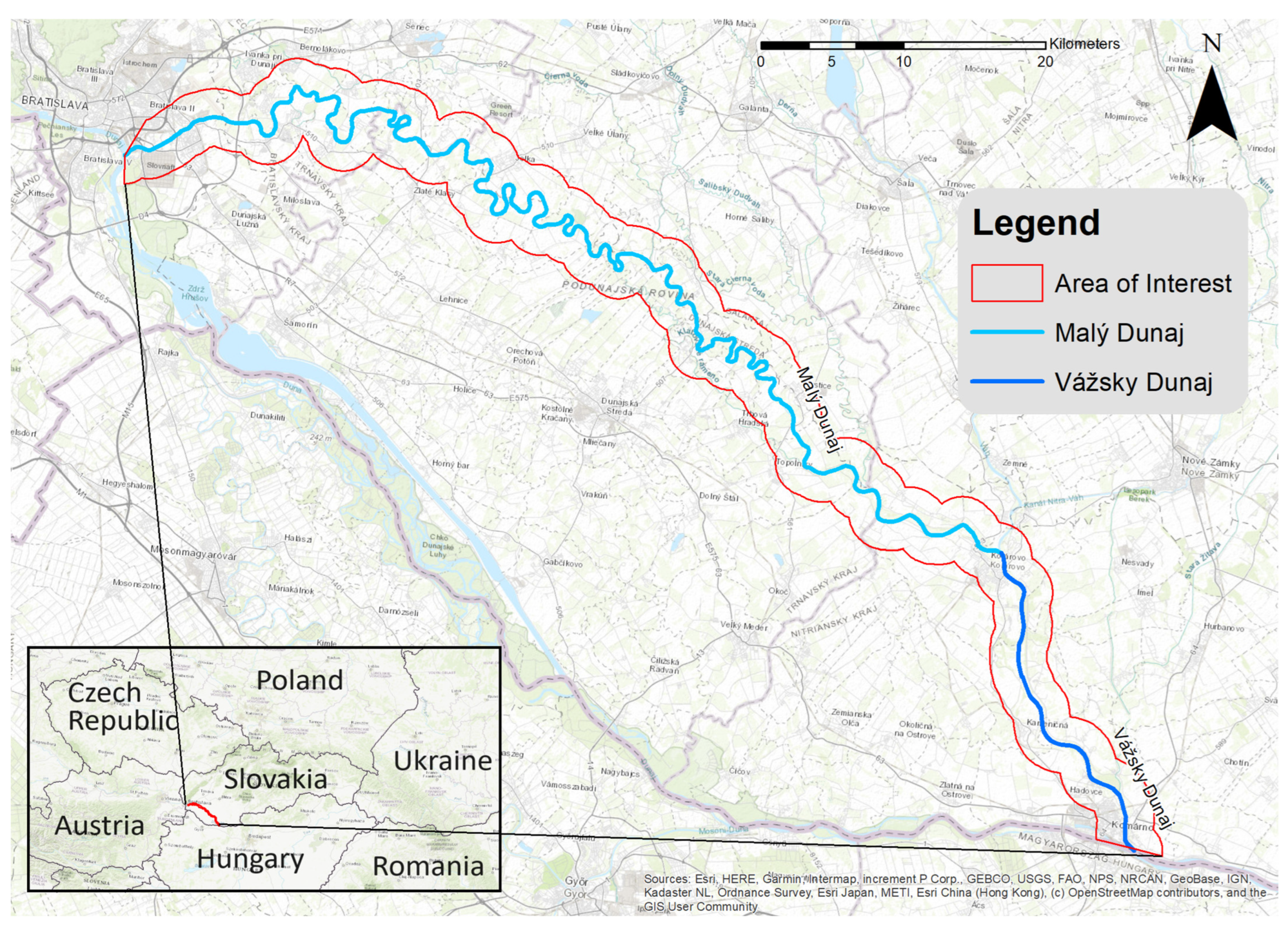
Conflicts of the Land Use and Ecosystem Services in the Riverine Landscape of the Little Danube

by
Viktória Miklósová
and
Ivana Kozelová
*
Institute of Landscape Ecology, Slovak Academy of Sciences, Štefánikova 3, 814 99 Bratislava, Slovakia
*
Author to whom correspondence should be addressed.
Water 2023, 15(24), 4221; https://doi.org/10.3390/w15244221
Submission received: 29 October 2023 / Revised: 26 November 2023 / Accepted: 29 November 2023 / Published: 7 December 2023

Abstract

:
Ecosystem benefits, now known as ecosystem services (ESs), confront continuous threats from human activities and lack adequate protection, often suffering degradation and destruction despite their inherent advantages. This paper aims to introduce the geosystem approach as an exact scientific basis for assessing ESs. By emphasizing the interconnectedness of abiotic and biotic components within ecosystems, this method involves in-depth research across landscape dimensions and socioeconomic factors influencing the utilization of ecosystem services (ESs). It highlights a deep understanding of their connections and interactions. The key operational units, termed landscape–ecological complexes or geoecological complexes, result from fundamental research. Their interpretation as potentially useful for the chosen ESs is already an applied procedure. ES assessment employs two approaches: participatory and biophysical assessments. The outcomes contribute to the development of management measures for preserving or enhancing ESs in the broader study area. Methodological procedures were tested in the Little Danube model area, a unique lowland stream in Central Europe’s Rye Island and a significant drinking water reservoir. The assessment results provide a foundation, supporting arguments, and criteria for ecologically appropriate landscape planning, as well as the sustainable management, utilization, and conservation of natural resources.

1. Introduction

The decisive problem for humanity’s survival on Earth is that the geobiosphere “shrinks” relative to the growth in the human population, which affects not only the accelerating depletion of nonrenewable resources but also the degradation of the conditions for the regeneration of renewable resources [1]. The mapping of ecosystem services (hereafter ESs) can contribute to a better understanding of the interrelationships between the ecosystems in a territory and the benefits they provide for society, which should result in more efficient use of the ecosystems in a given territory and their maintenance, as well as the protection of habitats [1,2,3]. As remote sensing provides an effective source of data for monitoring ecosystem services and land use changes in a watershed, we used it to obtain baseline data for our research. And for the evaluation of our data, geographic information systems proved to be the most suitable tools.
In this study, we focused on ES assessment around the Little Danube, a lowland river (hereafter the study area) in southern Slovakia. After passing Danube Gate, the Danube River creates an inland delta filled with thick layers of gravel and sand, forming a very valuable aquifer containing the largest reservoir of drinking water in Central Europe—Žitný ostrov (Rye Island) [4,5]. The study area represents the northern border of this river island. At the same time, Žitný ostrov is a valuable source of various productive ESs derived from its high-quality soils [6,7].
The Little Danube—a specific, strongly meandering lowland stream, whose adjacent ditches and their riparian vegetation provide refuge for animals—contributes to the stabilization of agricultural land and represents migration corridors for animals [8]. This significantly increases the biodiversity and spatial ecological stability of the landscape [9]. Hence, it is important to preserve the value of the area. The level of biodiversity is a key element that influences the ability of ecosystems to provide a broad scale of ESs and maintain their stability [10].
A number of significant issues prevent the optimal use of the rich resources in this area [11]. The major pressures facing European rivers are related to pollution, hydrological changes, and hydromorphological alterations [12]. Polluted water in the Little Danube significantly affects the water surrounding Žitný ostrov [13]. The pollution originates from industrial factors, mainly from chemical plants at the eastern border of Bratislava city, which were built during a period of intensive industrialization. Water management adjustments to the groundwater and surface water have gradually changed and regulated the riverbed of the Little Danube and the whole river system of Žitný ostrov over the 20th century. These changes, needed and justified at the time, allowed for the prevention of floods and the faster drainage of inland water by creating a system of dams and irrigation and drainage ditches around the streams in the study area [14]. However, these interventions have had a significant and often negative impact on the network of surface water bodies, oxbow lakes, and channels [15].
The area still lacks a comprehensive scientific study that can serve as a basis for the planning of the optimal land use and ecostabilizing measurements. Existing sectoral approaches are considered to be positive; however, they are not based on a complex ES assessment. Sectoral approaches have resulted in conflicts of interest between intensive agriculture and the protection of underground water sources, as well as nature conservation. Additionally, they conflict with the goals of nature conservation, which aim to protect unique ecosystems in a comprehensive manner.
The aim of our study is to present the results of the assessment of natural values and ESs in the study area that can serve as a basis for planning procedures [16,17,18], including an outline of the prospective measures [9]. However, the quantitative projecting of these measures is outside of the scope of the presented paper.
The scientific basis of our research was an integrated landscape–ecological and geoecological understanding of the ecosystems [9,16]. The definition of ecosystem has been the same since its introduction by Tansley [19]: The ecosystem is a complex system of a “house” and its “inhabitants”. Its material components are the abiotic surroundings (i.e., physiotop) and the biocenosis (i.e., the site and the cover). This means that both parts of the ecosystem should be considered at the same level during the ES assessment rather than focusing analytically on their individual elements. In our case, permanent abiotic conditions, such as water, topography, and soils, are more crucial from the ES perspective, because the change in biotic components depends on the protection and use of abiotic conditions (see Sections below).
In Slovakia, this concept is supported by legislation as a mandatory part of territorial plans and agricultural projecting [9,17,18,20].
Opportunities to improve cohesion are most apparent in the support for the integration of the concept of ecosystem services in the implementation of existing EU policies at national and regional levels [21]. There has been great progress; however, there is still a gap between research and implementation [21,22].

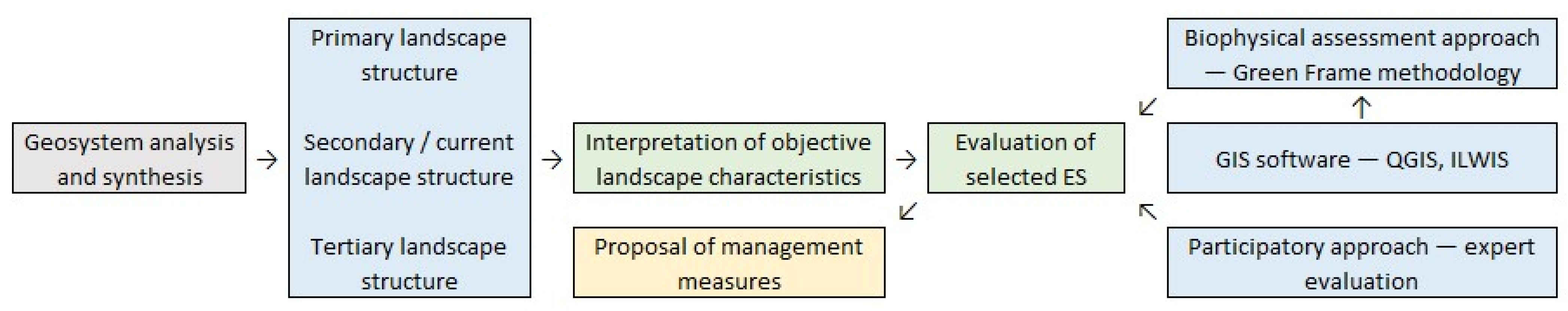
2. Materials and Methods

The study area is a 2 km broad buffer zone on both sides of the Little Danube (Malý Dunaj) river and the Vážsky Danube (Vážsky Dunaj) river in south Slovakia. Together the streams are 153.5 km long. The length of the Malý Dunaj river is 128 km, and the length of the Vážsky Dunaj river is 25.5 km. The total area of the study area is 47 618.43 ha. The Little Danube is the longest left tributary of the Danube River, separated from the main course of the Danube at Bratislava. After confluence with the Váh River in Kolárovo town, the Little Danube, like the Vážsky Danube, joins the main stream of the Danube near Komárno town. The larger tributaries of the Little Danube include the streams Blatina, Čierna Voda, and Klátovské rameno (Figure 1).
Its watershed, together with adjacent streams and channels, creates a substantially different complex of natural and seminatural ecosystems compared with the surrounding intensively used agricultural landscape.
We used three interrelated procedures and methodologies (Figure 2):
(1)
Geosystem analysis and synthesis of the objective properties of the landscape as a basis for other applications
The basic concept for the analyses and syntheses of the area was the perception of the landscape as a geosystem [23,24,25,26,27,28,29,30]. Slovak legislation defines landscape as a geosystem in Act 50/1976 Coll. [31] of the territorial planning and building code (Building Act), as amended in Act 237/2000 Coll [32].
This concept is particularly suitable for the evaluation of ESs that depend heavily on the presence and flow of water in geosystems. It encompasses all landscape structures that affect the existence, movement, and quality of water, as well as the possibilities of its use. The distinction among these structures is very important for the use of ESs. We selected the indicators that most significantly influence the spatial differentiation and zonation of geosystem properties in the study area and, thus, most significantly influence the differentiation of ecosystem services provided.
We defined the landscape structures as the permanent potential of the landscape for ecosystem services (i.e., localization criteria), the secondary structure as the existing physical and biological condition (i.e., selective criteria), and the tertiary structure as the socioeconomic and legal prerequisites for the real use of the ES potential (i.e., implementation criteria):
(a)
Primary landscape structure—The abiotic components like the bedrock and Quaternary layers, microrelief, soils, and micro- and mesoclimates. They create environments and borders for the flow of water, material, and energy in geosystems;
(b)
Secondary/current landscape structure—The existing physical and biological conditions (i.e., selective criteria), and the biotic components, including land use and land cover, artificial objects in the landscape that affect water retention in the landscape, evapotranspiration, and the ecological stability of the landscape;
(c)
Tertiary landscape structure—Socioeconomic phenomena of the landscape for the real use of the ES potential (i.e., implementation criteria) [9].
(2)
Evaluation of the selected ESs as an applied methodology for the interpretation of objective landscape characteristics
The objective properties of a landscape as a geosystem provide many possibilities for the evaluation of different ESs. We selected four ESs based on the Common International Classification of Ecosystem Services (CICES) [33], according to the actual conditions of the landscape around the study area: (1) “provisioning (biotic)—cultivated terrestrial plants for nutrition, materials, and energy”; (2) “provisioning (abiotic)—surface water used for nutrition, materials, or energy”; (3) “regulation and maintenance (biotic)—lifecycle maintenance, habitat, and gene pool protection”; (4) “cultural (biotic)—physical and experiential interactions with natural environment”.
We assessed the ESs in the study area using two approaches:
(a)
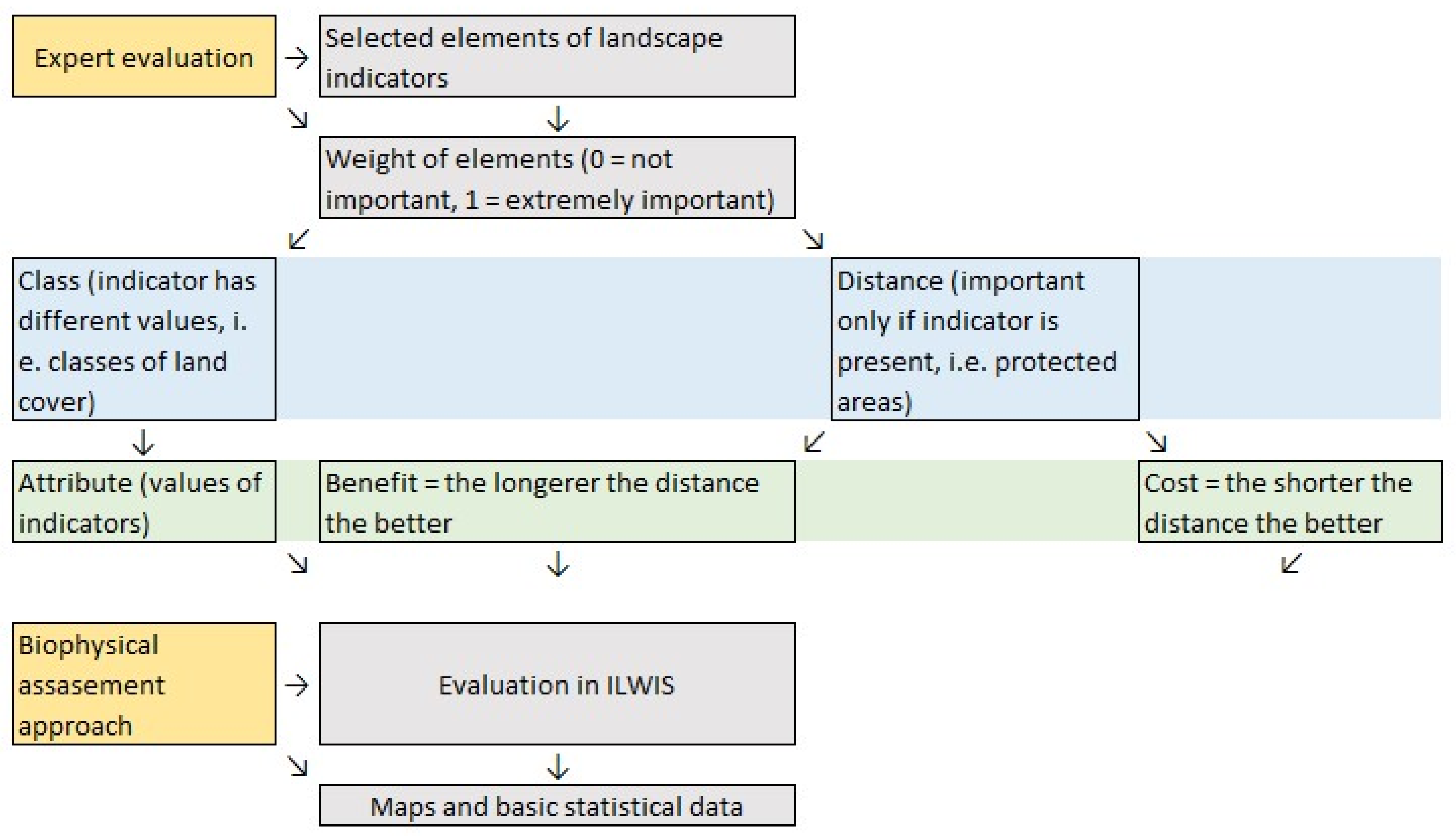
A participatory approach based on a field survey and an expert evaluation to select the indicators [14,17,34]. An interdisciplinary team of experts studied the area, selected the indicators that are relevant for the provisioning of the selected ESs, and assigned weights to them. The selected indicators of the primary, secondary, and tertiary landscape structures respect the character of the model area, most significantly affect the spatial differentiation and division of the properties of geosystems in the model area, and, thus, most significantly affect the differentiation of the ESs provided (Table 1).
(b)
A biophysical assessment approach based on the relationship between pressures on the ecosystems, ecological status, and the delivery of ESs to evaluate the ESs in the study area and their benefits. We used a Green Frame methodology scheme that was based on a comparison of the positive (support for the use of ESs) and negative (restrictions on the provision of ESs) elements of the landscape indicators [35] (Table 1).
We used GIS software based on 2D modeling—ILWIS 3.72. This program statistically and spatially evaluates raster maps of selected landscape indicators. According to the expert assessment, we weighted elements according to their relevance for the provisioning of the given ES, where zero is the lowest value (i.e., not an important element) and one is the highest value (i.e., a very important element). This weight determines the level of impact that indicator has on the potential of the selected area to provide the selected ES. For indicators that were evaluated as “distance”, only their presence in the area was considered important, as well as distance from them, i.e., protected areas. Negative factors were considered a “benefit” if the greater the distance from them the better, and vice versa positive factors were considered a “cost”. We assigned one weight to the indicator. Indicators were evaluated as “classes” when an indicator had more classes with different values, i.e., land cover. These indicators were considered as “attributes”, and we assigned different weights to the different classes (Table 1, Figure 3).
The result of the first step was an evaluation of the basic statistical data: minimum, maximum, and mean average. We performed the calculations using QGIS software 3.28.3 Firenze.
The functional objects for the application of the above-described process were spatial units of landscape–ecological complexes (LECs) with a defined set of values. We defined the values by overlapping the elements of the landscape structure and their indicators in GIS software. An important part of this spatial synthesis was the removal of illogical combinations of indicators that resulted from inaccuracies in the maps of input indicators that came from different sources.
(3)
Proposal of management measures for the optimal use of ESs
Ecosystems are, in principle, renewable resources that provide ESs. The key to solving the depletion of nonrenewable resources and degradation of renewable resources is the improvement in the management of ecosystems and improvement in the use of their outputs. Based on the landscape analyses and syntheses and the subsequent assessment of the ESs, we proposed measures for the optimal management of the study area. This approach involved using the assessment of the changes in land use and evaluating the ESs of the study area. The result is the proposition of a variety of ecological, physical, spatial, and management measures and practices, which aim to restore the function of the natural state of the study area in support of biodiversity and recreation. The presented measures are only qualitative. The quantitative values of the measures depend on more indicators than the presented landscape–ecological indicators. Therefore, qualitative measurements are the subject of our further research.

3. Results

We analyzed the primary, secondary, and tertiary landscape structures of the area of interest. On the basis of the results of the analysis, we evaluated the potential of the study area to provide the selected ESs. Finally, we proposed qualitative management measures to maintain or improve the ESs in the research region.

3.1. Primary Landscape Structure (PLS)

The study area is situated in the southwestern part of Slovakia, in the geomorphological unit Podunajská rovina [36]. According to the basic types of erosion–sedimentation relief, the study area is a relief of plains and alluvial plains. The maximum altitude of the area is 140 m above sea level, and the minimum is 105 m above sea level. The most significant geological phenomenon in the area is the massive layer of Neogene but mainly Quaternary sediments [37]. The thickness of the Quaternary gravels and sands in the study area is from 10 to 12 m, and in the center of the area, it is approximately 100 m. It reaches its greatest thickness, up to 400 m, in the Gabčíkovo Depression [38].
The hydrological regime of the study area is strongly dependent on the water table level and the direction of the groundwater flow. It is strongly influenced by manipulation at the distribution and intake structures, as well as the pumping stations [38]. The average depth to the groundwater table in the study area ranges from 1.52 to 6.7 m below the ground’s surface. From a genetic point of view, groundwater with potamogenic mineralization occurs here [39]. Anthropogenic influences also determine the chemical composition of the groundwater.
Along the Little Danube and Váh rivers, there are typical carbonate fluvisols of different grain sizes. Accompanying soil types are carbonate gley soils, carbonate chernozems, and typical carbonate chernozems, such as carbonate gley chernozems and carbonate chernozems, on carbonate alluvial sediments [40]. The soils are fertile, medium to heavy, deep, and without skeleton. The favorable hydrological regime in the area, established irrigation systems, and flat terrain contribute to their fertility. The high natural mineralization of the groundwater and the evaporation regime cause the salinization of the soils in many places. The high level of the water table causes temporary or permanent waterlogging and the occurrence of wetlands.
According to the climate classification, the study area is classified as a warm and very dry area with a mild winter. The average annual temperature is 10 to 11 °C [41]. The micro- and mesoclimates are dependent mainly on relief. Because the relief here is relatively homogenous, the micro- and mesoclimatic conditions are not very diverse [41].
The operational objects and spatial frame for the synthetic display of the PLS are abio-complexes (ABCs) [42]. Their system expression is as follows:
PLS {ABC (REL, ATM, GEQ, WAT, SOL)}
where ABC—abio-complexes; REL—georelief; ATM—atmosphere (climate); GEQ—geological substrate, including quaternary sediments; WAT—waters (surface and groundwaters); and SOL—soils.

3.2. Current Landscape Structure (CLS)
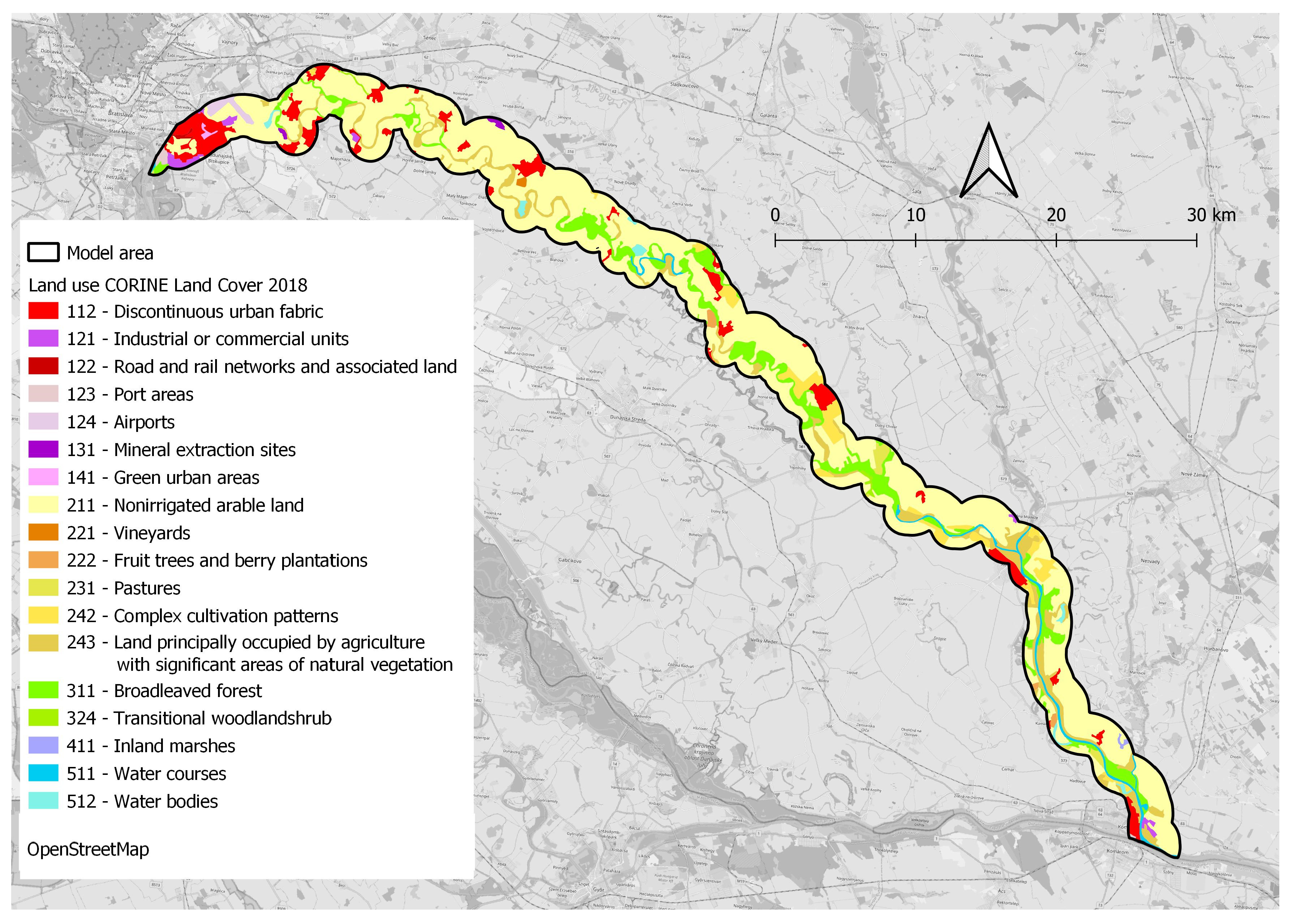
The mapping units of the current landscape structure (CLS) are physical objects resulting from land use. Together with ecosystem types, they form a spatial framework for the occurrence of biota. The system expression of the CLS [42] is as follows:
CLS {LUC [TES (VEG, ZOO)]}
where LUC—mapping units of the current landscape structure; TES—type of ecosystem; VEG—real vegetation in the ecosystem; and ZOO—real fauna in the ecosystem.
(1)
Land use/land cover—The basic frame elements of the CLS. The study area is one of the most productive agricultural areas in Slovakia. The most widespread type of land use is arable land, which accounts for 66.91% of the study area (Figure 4). Other significant types of land use are provided in Table 2. Despite the intensive cultivation and urbanization of the landscape, some natural areas of high landscape value remain preserved. These areas are forests with the original composition of trees, the natural parts of meandering water streams with the original riparian vegetation, parts of alluvial plains with the original biocenoses, or wetland habitats and riparian forest communities.
(2)
Real vegetation (VEG)—The elements of the CLS form a spatial framework for the real vegetation. We performed a floristic survey of the study area using a field survey [34]. At our level of analysis, we considered units of real vegetation bounded by the boundaries of the CLS elements as the ecosystem types to which the ESs are associated. Many native ecosystems have been converted into agricultural crops, various types of synanthropic vegetation, or grasslands. Forest cover is affected by silvicultural measures and is often transformed into monocultures [43]. Non-native species also have a significant impact on the forest cover.
Floodplain forests in the vicinity of the Little Danube have a secondary character, and a significant part of natural forests is converted into monocultures, with a preference for poplar cultivars [43]. They usually take the form of strips only a few meters wide. At the upper part of the river, near Bratislava, the forest is almost absent, and it is only present in the meanders of the river. Forests are surrounded by agricultural land and are under strong anthropogenic pressure. The current spatial distribution of floodplain forests is only a fragment of its original state.
(3)
Fauna (ZOO)—The real fauna in the ecosystems. We performed the research on the fauna with a field survey in the area of interest [34]. Since fauna are an integral part of the TES and strongly determined by the vegetation, we did not evaluate them separately.

3.3. Tertiary Landscape Structure (TLS)

Spatially, the TLS has the characteristics of zones, sections, bands, areas, or protected areas. They are defined in regulations of legal character: laws, decrees, directives, standards, methodological guidelines, or conventions. Socioeconomic factors (SEFs) are the bearers of guidelines, restrictions, and prohibitions on human activities planned or carried out in the area. We considered SEFs to be positive phenomena aimed at protecting nature and natural resources (Figure 5).
In the TLS, we also include stress factors (STFs) derived from the current land use [9,42,44]. The mapping of SEFs is crucial for detecting potential conflicts associated with management and planning practices [45].
The system expression of the tertiary landscape structure is as follows:
TLS {SEF (SEP, STF)}
where TLS—tertiary landscape structure; SEFs—socioeconomic factors; SEP—socioeconomic phenomena of a positive character; and STFs—stress factors.
We determined the SEFs in the study area according to the following groups (see also Figure 6):
(1)
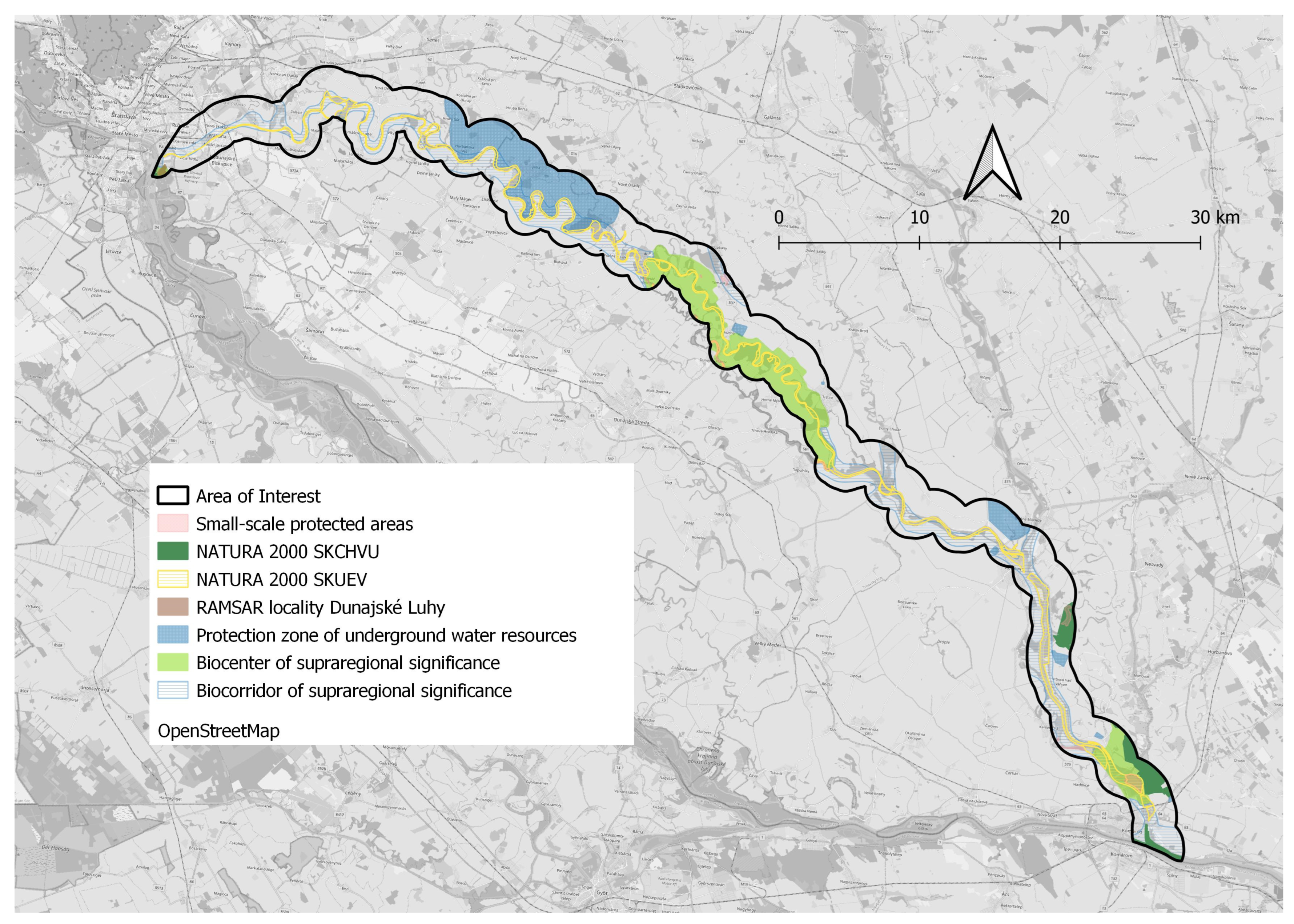
SEFs of nature protection. They directly indicate areas with the most significant values of biodiversity and with significant values of ESs of cultural and educational character. They represent significant limiting factors on all human activities, including recreation. The protected natural areas in the study area are as follows (Figure 5):
(a)
NATURA 2000; SKUEV0822 Little Danube; SKUEV0083 Eliášovský forest; and SKUEV0075 Klátovské river arm.
(b)
Territorial systems of ecological stability (TSES), pursuant to Act 543/2002 Coll. [46] on Nature and Landscape Protection, represent spatial structures of interconnected ecosystems, their components, and elements, such as the transregional biocorridor (NRBk), a stream of the Little Danube River composed of alluvial forests, linear riparian vegetation, and important gene pool sites of flora and fauna, and transregional biocenters (NRBcs), including NRBc Bratislava wetlands and the NRBc Little Danube Klátovské river arm.
(c)
Small-scale protected areas: protected areas—Tomášikovský Park; natural parks—Tomášikovský spillway; and national protected areas—Klátovské river arm.
(2)
SEF protection of water resources—The reservoir of drinking water in Žitný ostrov is constantly replenished by infiltration of water from the Danube River. Part of this reservoir is protected as an area of natural water accumulation (CHVO Žitný ostrov).
(3)
SEF protection of soil resources—The main characteristic of the soils is their legally approved rating classes, called rated soil–ecological units—BPEJ [47]. To the BPEJ are bound other significant SEFs, such as protection for soil resources, payments for exclusion from the agricultural land fund, taxes, and land price. The BPEJ classes have thus become an implementation criterion for the provision of ESs in the area.
(4)
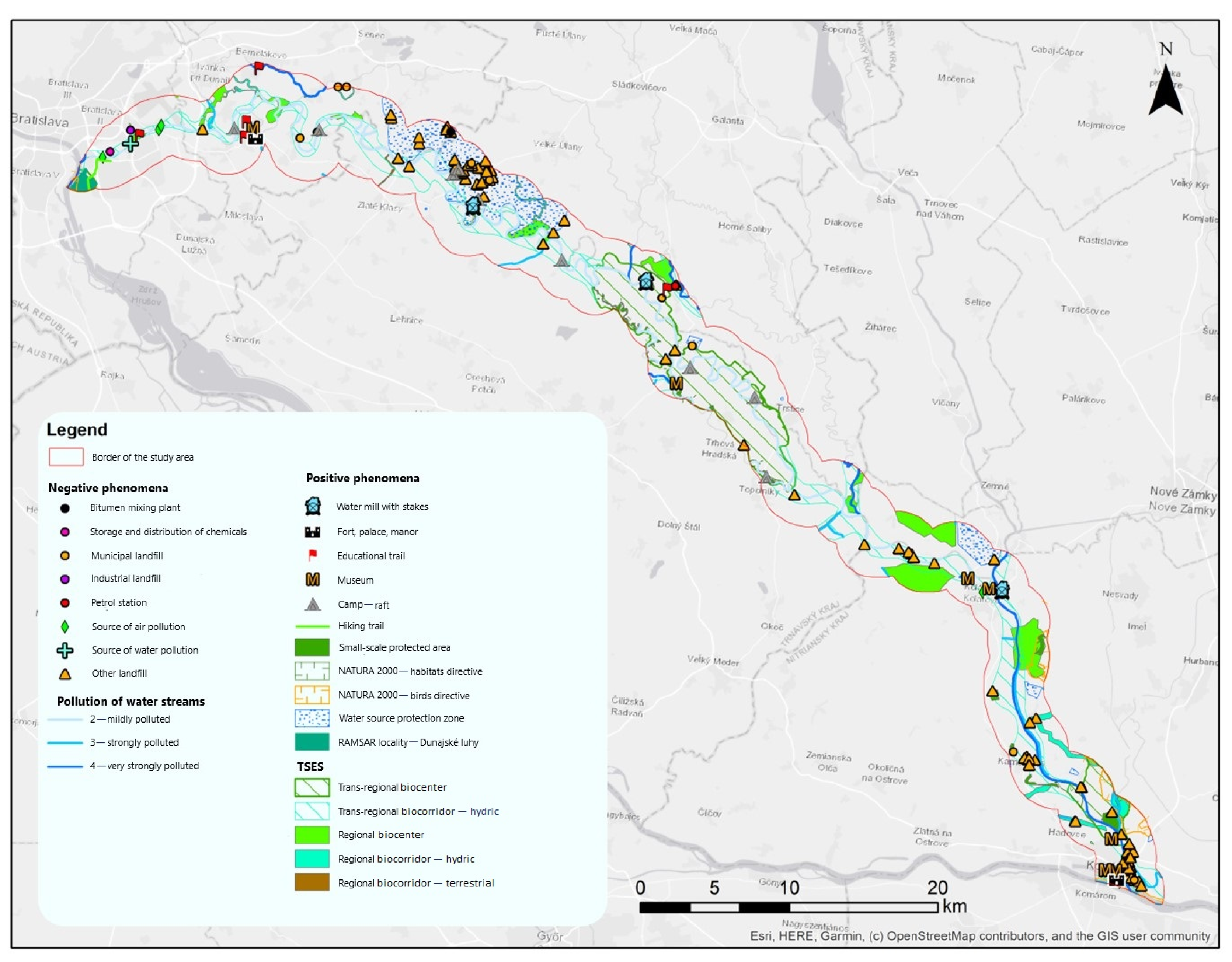
SEF environmental burdens—The environmental burdens in the area are sources of water pollution, bitumen mixing plants, manure dumps, old municipal and industrial landfills, sources of air pollution, wastewater treatment plants, and industrial wastewater [48]. These burdens are negative factors that significantly affect water resources, bioproduction, the gene pool, and other ecological functions [49,50].
As for the conclusion of the analyses and syntheses of the landscape structure, all of the above-analyzed components of the primary, secondary, and tertiary landscape structures can be synthetically expressed in spatial units, which we refer to as the landscape–ecological complex (LEC). The LEC contains the whole: abiotic base, land cover, and biota, and even SEFs (if they occur in situ) [42,51]. The spatial framework—the boundary in space—for this integration is usually the mapping unit of the type of current landscape structure (CLS), which can be considered as the ecosystem type [52,53,54,55,56].
The systematic expression of the LEC content is as follows:
LECS {ABC, (LUC, TES), (SEF, STF)}
where LECs—landscape–ecological complexes; ABCs—abio-complexes; LUC—land use and land cover; TES—type of the ecosystem (i.e., biotic characteristic); SEP—socioeconomic phenomena of positive character (legal supports or limits); and STFs—stress factors.
By this definition, the LEC becomes the basic topical operational unit for ESs [56].

3.4. Potential of the Study Area to Provide Ecosystem Services

We considered the evaluation of the ESs using our methodology to be a purposeful interpretation of the objective indicators of the primary, secondary, and tertiary landscape structures as a geosystem [9]. Every point of the landscape represents an integrating space, a scenario in which all natural resources occur as layers of the component of primary, secondary, and tertiary landscape structures, which are in permanent mutual functional interrelation. The properties of the individual resources and their combination in given space are the objective determining factors for the ES potential of the area.
The real results of this evaluation are linked to spatial elements of the landscape–ecological complexes (LECs). It is not necessary to express these spatial units graphically. They are recorded using GIS as a group of pixels from a raster map with the same set of values associated with the input parameters. Their basis is the abio-complex (ABC), and the spatial frame is represented by the mapping unit of the CLS. The mapping unit of the CLS indicates the type of ecosystem, including stress factors, which are also subject to legislative constraints.
The results of the biophysical assessment of the ESs are presented in Table 3. Values higher than 0.5 indicate a good potential for the provisioning of the selected ES. The results of the interpretation of the LECs as bearers of the selected ES are also presented in the form of maps.

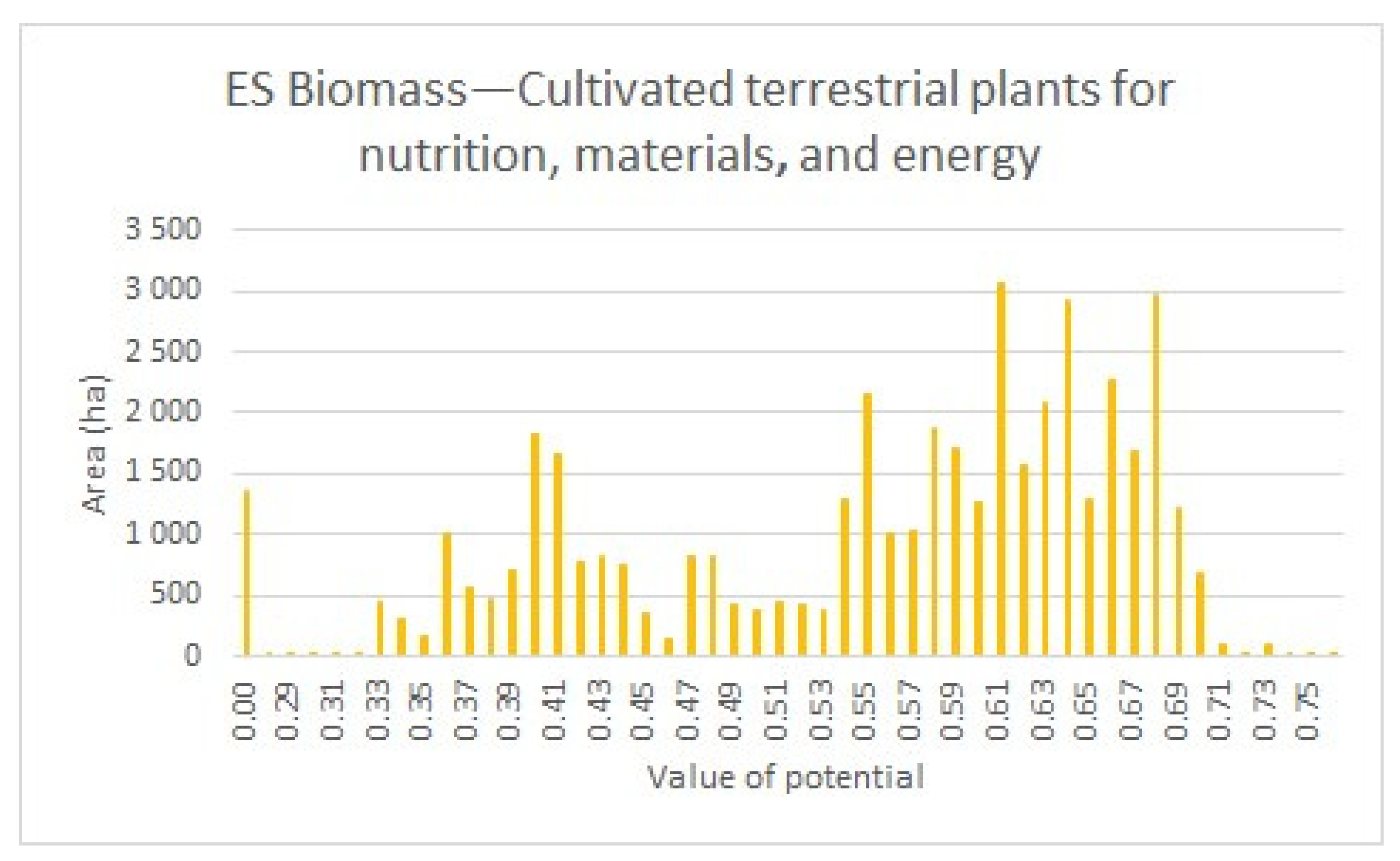
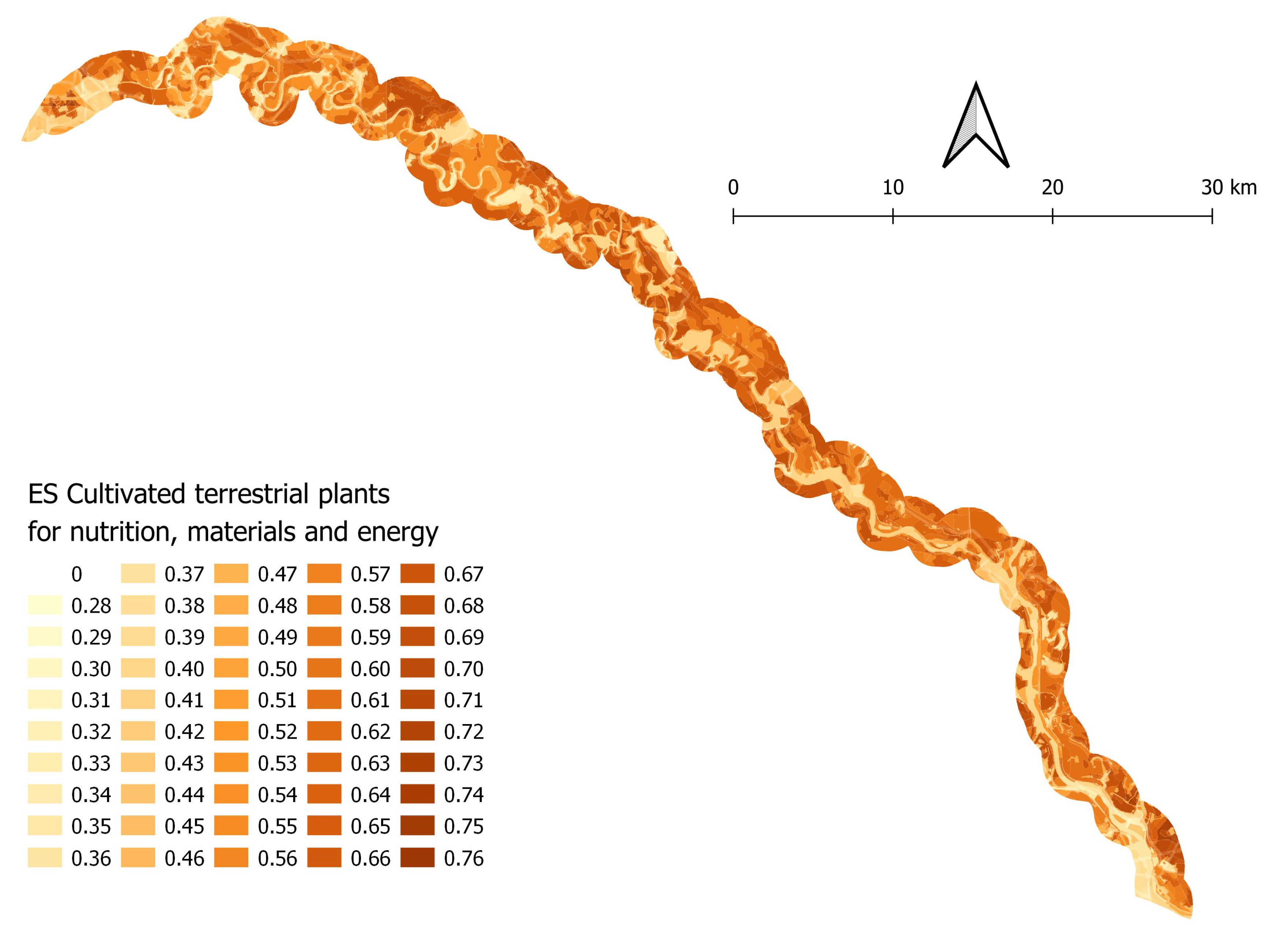
3.4.1. Potential of the Study Area for the ES “Biomass—Cultivated Terrestrial Plants for Nutrition, Materials, and Energy”

In terms of ESs, the structure of the study area is relatively simple. The largest part of the area is covered by high-quality agricultural land on a plain that has a very high-value ES for biomass provisioning [57,58,59]. Agriculture in the area is dependent on climate, soil, and water conditions. The type of soil and accessibility of water for biota are crucial criteria for assessing the potential for the provision of ES biomass production determining the suitability of areas for the cultivation of different crops, and, on the contrary, also for limiting their cultivation and development of biota, including crop production and the overall yield.
In the conditions of the model area, the highest yield is possible to achieve by farming arable land. Therefore, the CLS element “arable land” with high-quality soils has the highest potential for this ES. According to the results of the biophysical assessment, the model area has very good potential for the provisioning of this ES, in which 70.38% of the area has a potential of 0.5 or higher, with a mean value of 0.5 (Table 3). This potential is distributed unevenly (Figure 7 and Figure 8).
Within the structure of arable land prevail cereals and fodder crops, such as wheat, barley, alfalfa, and maize. Sunflower is cultivated too, mostly for its economic value. The main fertilizer in many villages is manure. The use of industrial agricultural fertilizers has recently declined, and there has been a decline in the intensity of mechanization.
There are large orchards in many places in the study area. Gardens with cottages are used for growing vegetables and fruit but also for recreational purposes. They have a very high biomass production value.
Forests, greenery, wetlands, water streams, and water bodies cover other parts of the study area. They are linked to the channel system and arms of the Little Danube and Vážsky Danube. These areas have low values for ES biomass provisioning, but they have high values for the preservation of the gene pool, biodiversity, regulation of water quality, climate, recreation, research, etc.

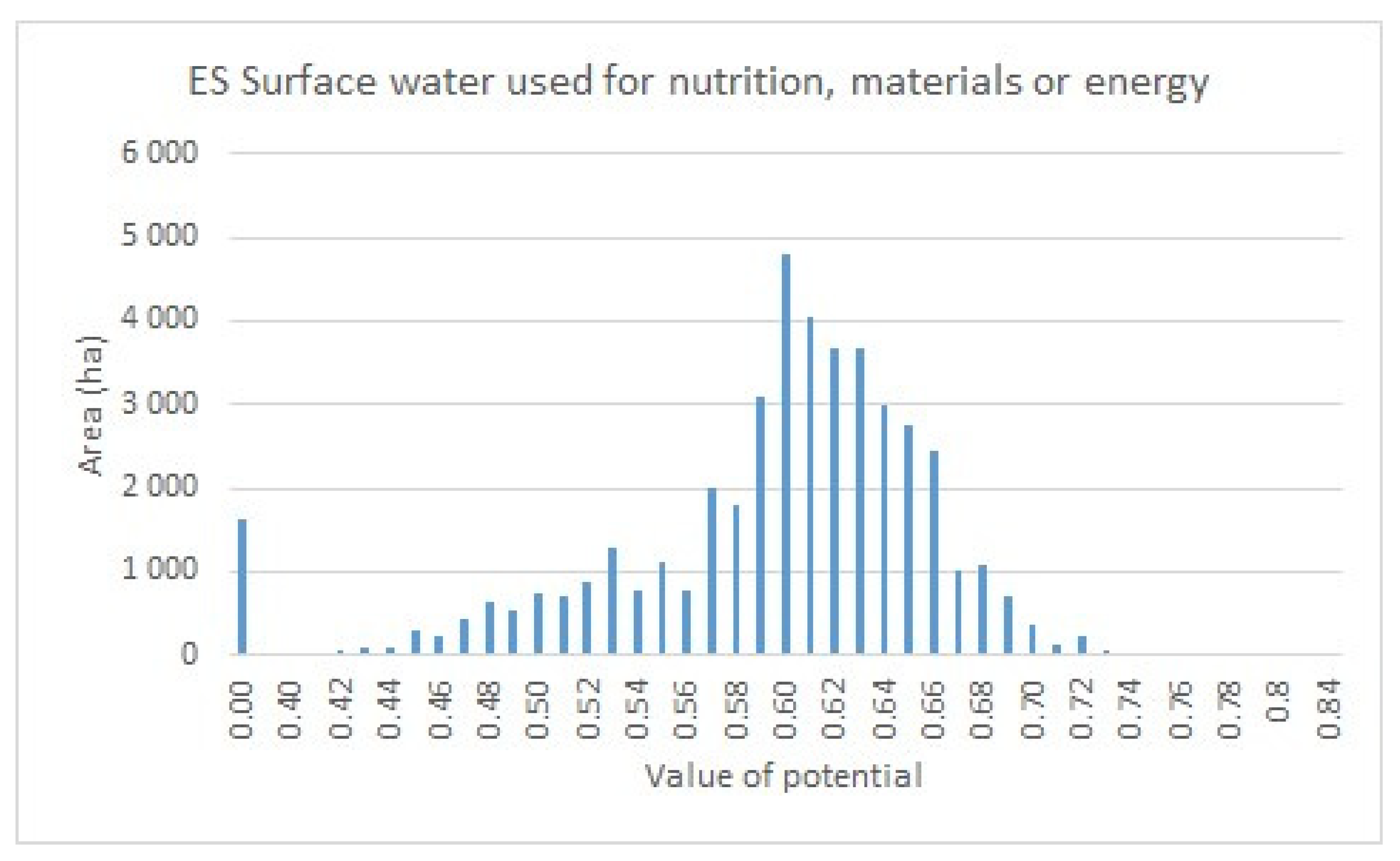
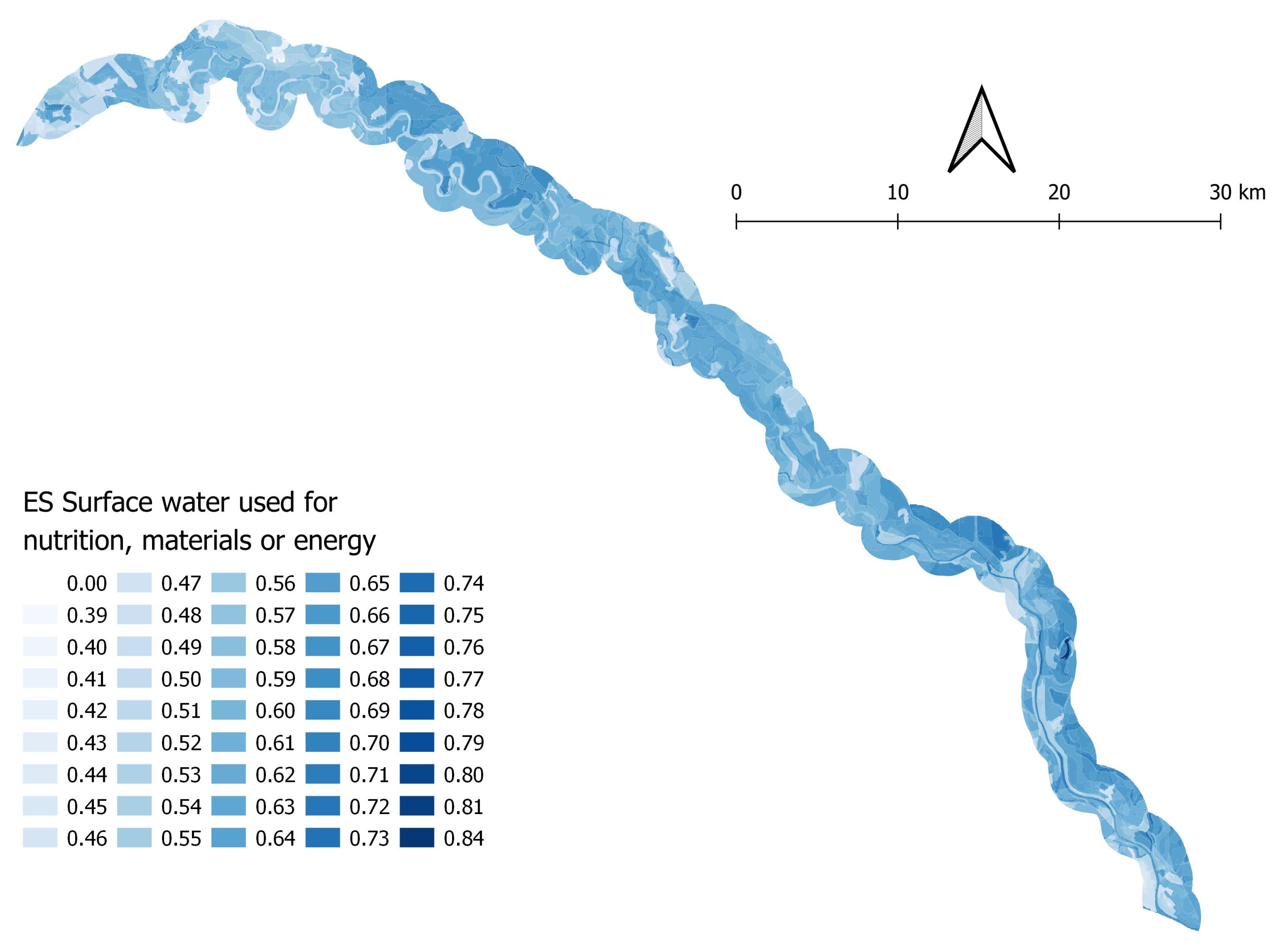
3.4.2. Potential of the Study Area to Provide ES “Surface Water Used for Nutrition, Materials, or Energy”

This potential is the main value of the study area. From a physical point of view, its value is the same throughout the study area. The basic factor is the same throughout the study area: the water resources are protected by the protected water management area Žitný ostrov, which regulates possible threatening factors. The law protects and regulates both the sources and abstractions of drinking water and sources of thermal water.
The characteristics of the study area indicate that water-based ecosystems have the greatest potential for provisioning this ES [59]. According to the results of the biophysical assessment, the model area has very good potential for the provisioning of this ES, in which 91% of the area has a potential of 0.5 or higher, with a mean value of 0.60 (Figure 9 and Figure 10, Table 3). The most important ecosystems are the streams of the Little Danube and Vážsky Danube and their tributaries. Existing ecostabilization elements, like floodplain forests, riparian vegetation, and woodland shrubs, are also significant for this ES.
A special feature of the potential for this ES is the presence of geothermal waters. There are two geothermal wells in the study area used for greenhouse farming.

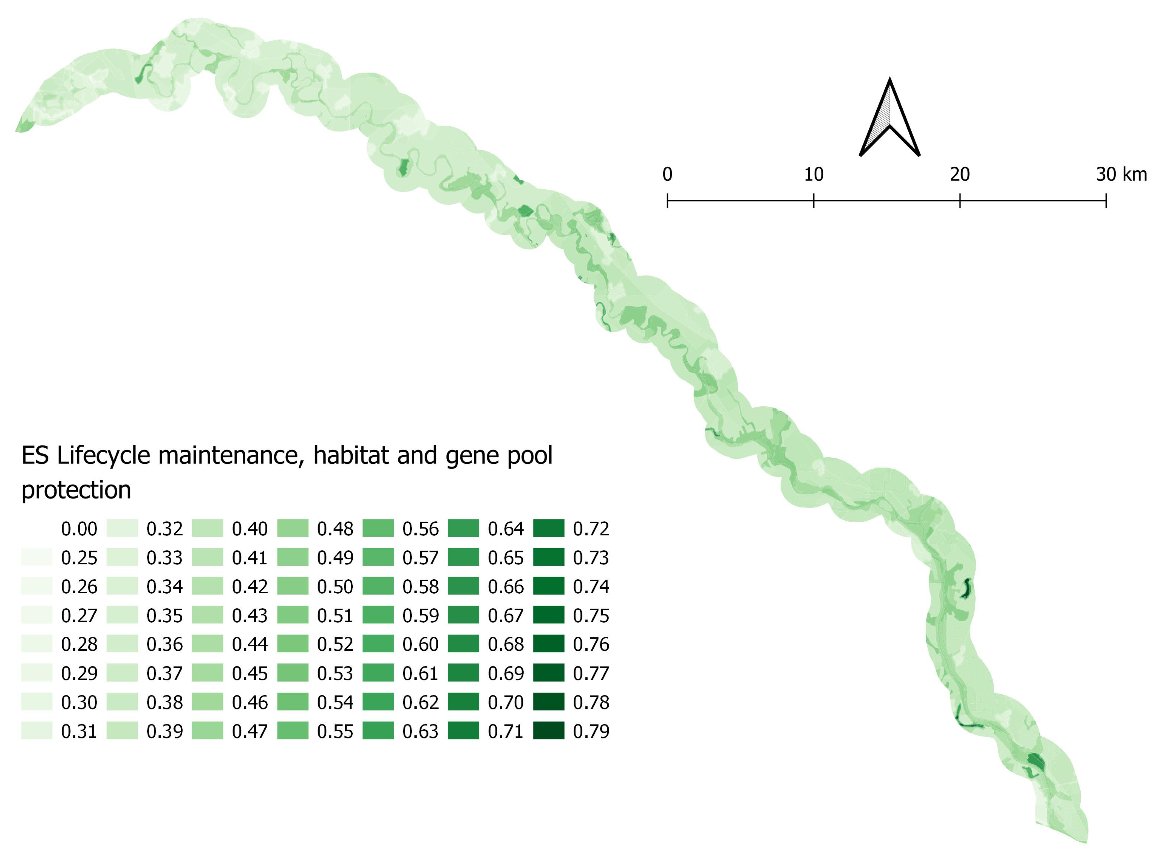
3.4.3. Potential of the Study Area to Provide the ES “Regulation of Physical, Chemical, and Biological Conditions—Lifecycle Maintenance, Habitat and Gene Pool Protection”

This potential depends mainly on the type and quality of the biota in the CLS elements and the characteristic indicators of the abio-complex (geology, soil, relief, and water). These indicators have conditioned the proposal of ecostabilizing measures in the landscape.
The most important elements of this ES are the stream of the Little Danube River and other water bodies, oxbow lakes, and channels, which aid in the preservation of the biota and gene pool specific for this area.
According to the results of the biophysical assessment, the model area has moderate potential for the provisioning of this ES, whereby 2.84% of the area has a potential of 0.5 or higher, with a mean value of 0.5 (Figure 11 and Figure 12, Table 3). A good potential for the provisioning of this ES is only found in areas directly next to the watercourse.
Other important elements are also linked to water, namely broad-leaved forests (especially soft floodplain forests), riparian vegetation, line greenery that accompanies watercourses [60], as well as permanent crops and agricultural mosaics (i.e., gardens), and transitional woodland shrubs, which are important refuges for plants and animals in the intensively farmed agricultural landscape and urban landscape.
Elements with a high level of biodiversity in the study area include the following:
  • Side stream of the Little Danube—Klátovské river arm, with the most important habitats along the stream. It is a national natural reservation with the highest level of protection (fifth level) [46]. At the same time, this area is part of the NATURA 2000 network as a site under the Habitats Directive.
  • Riparian vegetation along stream of the Little Danube is protected by law [46], as a protected zone of the nature reserve, up to 100 m from the boundary of the nature reserve with the third level of protection.
  • Areas with remnants of floodplain forest and groups of important tree species—protected elements with various levels of protection.
  • Riparian vegetation and greenery along the streams—they are protected by regional TSES as biocorridors and biocenters.

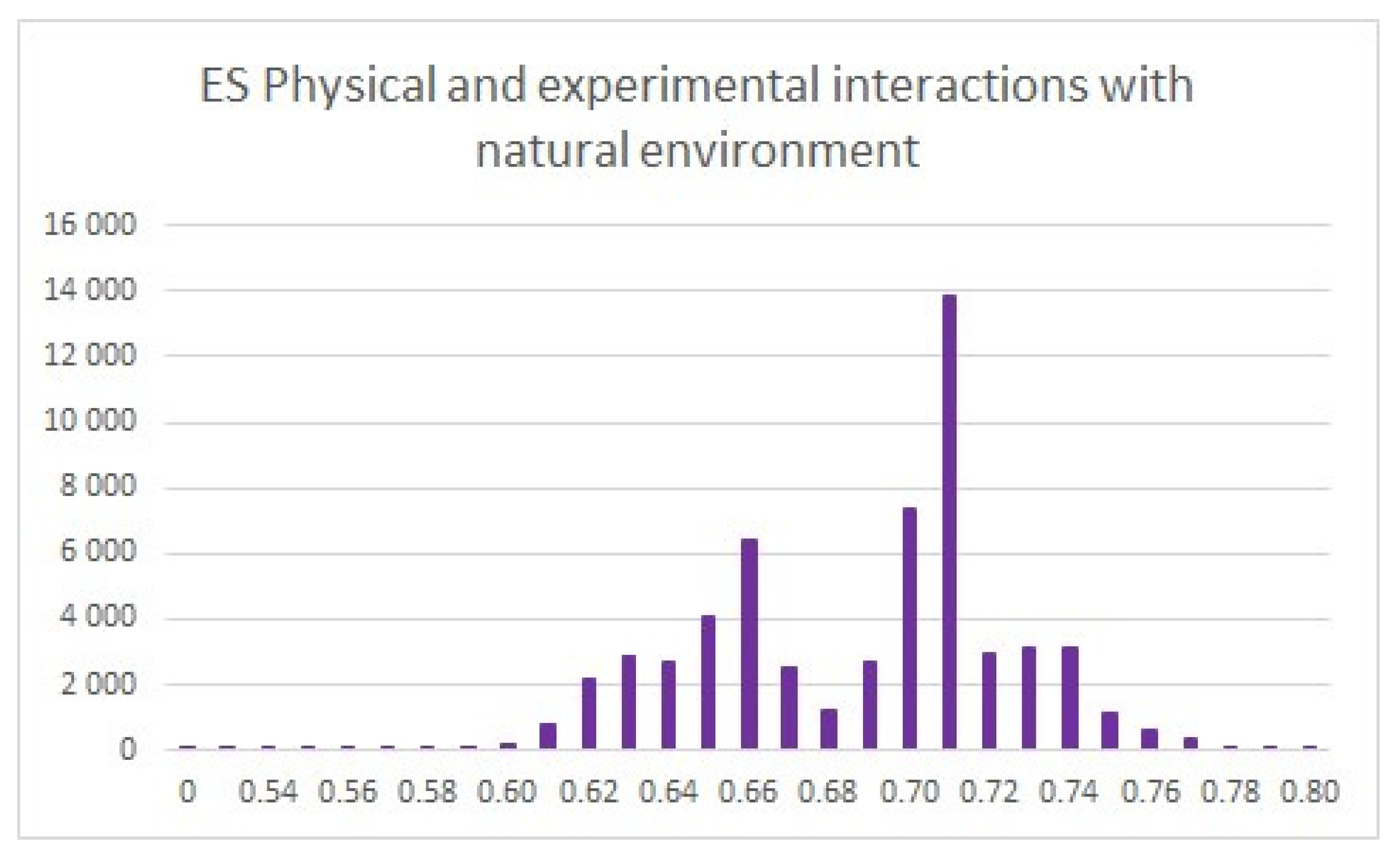
3.4.4. Potential of the Study Area to Provide the ES “Physical and Experiential Interactions with the Natural Environment”

For the regeneration of physical and mental strengths, daily rest in a suitable apartment, as well as relaxation and sporting activities close to one’s dwelling, are essential prerequisites for health [61]. This potential in an area depends on the quality of the elements that provide everyday living and rest, i.e., the quality of the housing; possibility of gardening nearby one’s home; everyday leisure activities, as well as sports and recreational facilities, near one’s residence; and the physiognomic character of the ecostabilizing elements that potentially mean a prerequisite for a stay in nature (forests, riparian vegetation, meadows, and pastures).
In the urban fabric, sports and leisure facilities have the greatest potential for providing this ES. Many residents consider gardens (elements such as permanent crops and complex cultivation patterns) to have high potential for this ES. Areas with ecostabilizing functions, such as broad-leaved forests (mainly soft floodplain forests), riparian and line vegetation, water bodies and watercourses, wetlands, meadows, and pastures, also have high potential for this ES. According to the results of the biophysical assessment, the model area has very good potential for the provisioning of this ES, whereby 99.89% of the area has a potential of 0.5 or higher, with a mean value of 0.7 (Figure 13 and Figure 14, Table 3).

3.5. Proposal of Management Measures/Ecostabilizing Measures to Maintain or Improve ESs in the Wider Study Area

The proposed measures were a choice of the kinds of qualitatively defined measures used in different sectors, which have also been implemented in the surrounding areas of Rye Island. On the basis of the research results, we consider the same measures to be applicable to our study area, but not individually, rather as a complex. There are two groups of measures, which are linked to compromises between intensive use and the protection of natural and water resources.
(1)
Elimination of the impact of stress factors on surface water and groundwater
The source of the surface water pollution in the study area is mainly intensive agriculture. Other causes include unregulated landfills near the stream and the fact that complete coverage of the area by wastewater treatment plants is still lacking. Therefore, the following are needed to protect water:
(a)
Monitoring as a basis for the measures: continuous and thorough monitoring of the water quality in the Little Danube, including microbiological and organic pollution, and a thorough investigation of the discharges of polluted water from industrial and agricultural sites;
(b)
Regulation of livestock production: stopping or preventing the operation of farmyards that have technical conditions that do not comply with hygiene principles;
(c)
Land use changes: reducing the intensive arable farming along the stream’s meanders, namely the conversion of arable land into grasslands, avoiding the use of fertilizers, and implementing organic farming that uses green manure (incorporating vetch, alfalfa, clover, etc., into the sowing procedure);
(d)
Landfills and sewage system: preventing unorganized and illegal landfills; completing the public sewage system with the use of water treatment plants.
(2)
Protection and restoration of natural sites
(a)
Excluding intensive forestry activities near the flow of the Little Danube and the renewal of forest management plans [62];
(b)
Revitalization of the wider surroundings of the stream, including the prevention of the erosion of the banks;
(c)
Restoring the natural state of microdepressions—the bottoms of meliorated depressions, such as dead river arms and oxbow lakes—after these sections are excluded from agricultural use and left, becoming overgrown with wetland vegetation.
The quantitative definition of the different sectoral measures is not within the scope of the present article. Quantitative values for these measurements also depend on factors other than landscape–ecological indices and are now under elaboration.

4. Discussion

As defined by Izakovičová [50], ESs are at the interface of natural and social systems. While natural systems create the supply for the provision of services, socioeconomic systems represent the demand for these services [17,63,64]. There are several approaches to ES mapping, and several overviews of methodologies are available.
The study of ESs at the landscape level is usually performed via the inclusion of land use/land cover typologies [65,66,67,68,69], and, at the same time, social perception of ESs or landscapes [70,71]. However, a linear relationship is usually assumed between ecosystems and the provision of their services. This theory is unlikely to be universally valid and excludes existing relationships among individual ESs [72].
Given the complex linkages and relationships between ESs and human well-being, a nonlinear, complex, and context-dependent approach is expected [73], which in the scientific community has led to integrated assessment methods [74,75].
The present paper introduces a different method—a geosystem-based approach to ES assessment [42].
The analyses deal not only with land use/land cover but also with all three basic structures of landscape: primary (abiotic), secondary (land cover and biota), and tertiary (socioeconomic) structures. They all markedly influence the ability of ecosystems to provide ESs. The basic operational units were spatially defined landscape–ecological complexes (LECs), defined as all of the abiotic indices, land cover, biotic indices, and socioeconomic limits within the GIS. In this way, we could distinguish in the evaluation process between landscape characteristics that represent locational, selective, and realization criteria in terms of their utility properties, i.e., the locational criteria—the relatively stable potential of the landscape supply for ecosystem services; the selective criteria—the existing but changeable physical and biological states of the current landscape structure; and the realization criteria—the socioeconomic and legal prerequisites for the actual use of this potential. The mapping units of the current landscape structure (CLS) are the basis of the various analyses of the area and the entire following assessment process. On the basis of this, we can identify the areas in the current economic activities that may support or negatively influence the use of ESs in a given area. It is also possible to evaluate the current state of the anthropization of the area based on the proportion of single elements in the CLS. The level of anthropization indicates whether the area is natural with a high landscape–ecological value or whether it has been altered at different levels.
The results of the analyses and syntheses were the characteristic and spatial differentiations of the LECs of the area of interest, which formed the basic database for all other procedures.
The creation of the LECs is the result of basic research, since further steps—the assessment of the properties of the LECs for the ESs—are part of a goal-oriented interpretation. In addition, LECs have more general use than just ES assessment. They can be interpreted for several other goals in different applied landscape–ecological studies.
Considering the specifications of the study area, four ESs were assessed. The results of the assessment are provided in the maps (Figure 5, Figure 6, Figure 7 and Figure 8). We elaborated on all steps, such as the analyses and syntheses, as well as the interpretation of the LECs and the results of the ES assessment in the GIS.
The characteristics of the assessed ESs in the study area are as follows:
Under the conditions found in the study area, it is possible to achieve the highest level of biomass production by managing arable land (Figure 8). However, the increasing intensity of agriculture is undermining the ecological stability of the area [17,76], and it threatens water and soil resources through chemicalization or intensive mechanization.
Since the elements of the primary and secondary landscape structures are very favorable for this ES, the elements of the tertiary landscape structure have different impacts on it.
A large part of the area of interest is covered by the most fertile soils in Slovakia, with the highest rated soil–ecological unit (BPEJ) classes, which require strict protection. This criterion clearly identifies the high value of the area for food production, as well as restrictions on any nonagricultural use. It follows from various studies that land conservation is the best way to achieve high levels of biodiversity conservation and commodity production [77]. The legal protection of high-quality soils has a supporting function for ES biomass provisioning. This factor determines which areas are under strict protection with a clearly stated purpose for food production and which areas may have purposes other than agriculture.
The protection of water resources is a significant limiting factor for ES biomass production. Protected water management areas in Žitný ostrov and sanitary protection zones for water sources occupy a large part of the study area and have a significant limiting function for industrial activities in addition to agriculture.
The environmental burdens on the study area are important factors threatening the provision of ES biomass, water resources, gene pools, and other ecological functions. We can consider the areas characterized by the application of large-scale fertilizer irrigation as cases of intensive point source pollution. However, thanks to the natural conditions (thickness of cover and geological composition), these cases do not cause such large changes in concentrations as do agriculture and urban areas.
In conclusion, the production of biomass is one of the main values of the study area. Nevertheless, the constant increase in the intensity of agricultural production has a negative impact on the structure of the landscape (disturbance of the ecological stability of the territory), as well as on individual landscape components (threatens water and soil resources through chemicalization, intensive mechanization, etc.) [11,57,76].
The study area has the best potential for providing the ES water supply, as it is physically the same throughout the study area. According to Mederly et al. [59], this ES depends on abiotic conditions and processes. The character of the study area implies that the ecosystems with the highest potential for providing for this ES are water-related ecosystems (Figure 10), like the streams of the Little Danube and Vážsky Danube, their tributaries, and surface water leaking into groundwater.
Water resources in the study area are protected by the protected water management area of Žitný ostrov. The law also protects and regulates the sources and abstraction of drinking water, as well as the sources of geothermal water. The protected water management area of Žitný ostrov is of crucial importance for the country’s water supply. This SEP has a major limiting function, mainly for industrial and agricultural activities (gravel extraction and livestock production).
On the other hand, the protected water management area of Žitný ostrov is significantly influenced by industrial and agricultural activities, residential development, transport, and recreation [16].
The threat to the potential of this ES in the study area is mainly pollution of surface water and groundwater because of waste from chemical facilities and intensive agriculture.
Systematic waste discharge into the surface water of the Little Danube in the past has caused pollution that subsequently leaked into groundwater nearby. Currently, it is not possible to remove this pollution completely. The most contaminated areas are riparian vegetation and the bottom of the riverbed of the Little Danube. The most common pollutants in this area are petroleum and chemical derivatives, like pesticides, herbicides, or benzenes, from the former chemical plant Juraj Dimitrov in Bratislava. These zones still pose the biggest threat to ecosystems and the provision of this ES [48,78].
The groundwater quality is largely threatened by intensive agriculture. The problem is the intensive fertilization of the soil and the leakage of agrochemicals into groundwater and surface water through rainfall. No significant changes in agricultural land use are expected compared with the present.
These zones represent the greatest potential hazard to the aquatic ecosystems of the study area and still pose the biggest threat for ecosystems and provision of this ES [48,78].
Inadequately treated urban wastewater discharged to surface water, livestock farming, and landfills represent point pollution. According to data from the SHMÚ [38], the water quality in the Little Danube is improving over the long term. This improvement is related to the construction of wastewater treatment plants in the municipalities.
If the current state of the land use in the areas along the stream is maintained, we propose the exclusion of the use of inorganic and liquid organic fertilizers to prevent their leakage into water. We recommend organic farming that is green manuring (incorporating vetch, alfalfa, clover, etc., into the sowing procedure). Therefore, in addition to determining the most appropriate initial use of the area, it is also necessary to determine a set of ecostabilization measures that will enable the optimal functioning of the selected activities [78].
Landscape elements with a high level of biodiversity, like forests and water ecosystems, have a crucial potential for the ES “lifecycle maintenance, habitat, and gene pool protection”. According to the results of the biophysical assessment, the model area has moderate potential for the provisioning of this ES (Figure 12). This potential is basically threatened by the main economic activity, namely intensive agriculture around valuable habitats [59]. The riparian vegetation of the Little Danube and Vážsky Danube is highly damaged in many places. In some sections, there is a complete lack of tree and shrub vegetation. This phenomenon is the most dangerous on steep banks without vegetation. Of particular concern is the condition of and threat to the most important protected area: the Klátovské river arm. The problem is that there is no buffer zone between intensively cultivated land and streams in the study area. Moderately used grasslands are a good example of such a buffer zone [79]. This ES is basically threatened by the main economic activity, namely intensive agriculture around valuable habitats [59]. A key criterion for the increase in the provision of this ES is the protection of existing landscape elements with a high level of biodiversity from devastating interventions.
Since we are discussing not only the current situation but the future potential as well, we also attributed a high potential to large-scale arable land. It is suitable for future ecostabilizing functions that are associated with the characteristics of ABC, which can be proposed. In the future, it can provide functions for the preservation of and improvement in the biodiversity, gene pool, and ecologic stability of the area. Wetlands and water ecosystems may also be proposed as ecostabilizing elements in the future, with protection proposed at the fifth level, at least, for nature reservations [46].
Ives et al. [80] and other authors claim that the potential of the ES “Physical and experiential interactions with the natural environment“ strongly depends on the quality of the elements that provide everyday housing and leisure and recreational activities near a residence, such as sports and recreational facilities. The presence and quality of ecostabilizing features are the potential conditions for staying in nature (forests, riparian vegetation, meadows, and pastures). Housing in the study area has a mainly rural character, predominantly in detached houses with gardens. Apartment houses are less common. New areas of individual housing construction have characteristics of residential parks without gardens or only with a small ornamental green yard (Figure 14). This activity is limited by zoning plans, which also reflect the restrictions from the protection of the land fund. Housing, domestic relaxation activities, and the quality of the environment are at a good level, without major problems. Each settlement has areas with some recreational facilities, but only a few of them are of broader importance.
The water mill near the Dunajský Klátov, Jahodná, Jelka, and Tomášikovo settlements and the ship water mill in the Kolárovo settlement belong to unique cultural and historical monuments. The presence of geothermal water can be considered a specific, small-scale element of the potential for this ES. The swimming pool in the Topoľníky settlement uses the geothermal water in this area.
Staying outdoors in the open air, especially in forests and riparian vegetation, is regulated by the physiognomic character of growth (throughput) and legal protection of nature. The law protects the Klátovské river arm and its surroundings, and they are among the most attractive parts of this area. The threat to the potential of this ES is intensive agricultural production, which may cause dustiness and allergies. The restrictions resulting from nature protection, especially the protected area of the Klátovské river arm, cause problems for its use in water sports. Road traffic, leisure facilities, and other threats are less important in the study area.
From an environmental point of view, typical problems related to agricultural land are accumulating in the study area. The decisive integrating characteristic here is the existence of a monofunctional intensive agricultural landscape with large-scale arable land and a low level of ecological stability [81].
The main factors that threaten and limit the use of ecosystem services in the study area [9,11,82] are the following:
  • Land use/land cover: the intensively farmed agricultural land significantly limits the surface area and qualitative development of other landscape types, like grasslands, forests, and water elements;
  • Economic activity: the soils in the study area are among the most fertile soils in Slovakia, which serves as the basis for primary agricultural production and related industrial activity, water management, urbanization, and recreational activities;
  • The endangered water quality of the Little Danube and the polluted surface water and groundwater negatively affect the provisioning of ESs;
  • Environmental burdens threaten the provision of the ESs of water resources, bioproduction, gene pools, and other ecological functions;
  • Legislation and the protection of territory is a positive factor in the protection of nature and natural resources. At the same time, it significantly limits economic activity including recreation.
Agriculture, housing, the expansion of industrial and service areas, transport, and recreation are also putting great pressure on the current state of the ecosystems in the study area [17,83]. There are different sectoral measures mostly aimed at agricultural practices and water protection in the surrounding previous agricultural and settlement areas, but they are not oriented specifically to our study area, which is a complex mosaic of different ecosystems. In detail, this mosaic needs a complex, cross-sectoral interlinked system of measures.
Finally, the measures are in the competence of single sectors but, at least, they should be involved as an interlinked system of measures in plans that cover the whole space, such as territorial plans and agricultural field consolidation projects [84].
The realization of the proposed kinds of measures also requires the active involvement of the population to resolve local relations and conflict points in the territory. The final goal is the improvement of general comfort and quality of life. The ideal solution is to manage the area in a way that provides a compromise between nature conservation, protection of natural resources, and the interests of local people. We consider it crucial to raise awareness and involve residents in the management process.
The proposal of the measurements represents a physical intervention into the area. The mode and the intensity of this require further investigation of the quantitative positive and negative impacts of the measures [85], including rigorous monitoring to track changes and, subsequently, to carry out further revitalization measures.
As defined in the Millennium Ecosystem Assessment [86], ecosystem management should be a coordinated process that supports the development and management of resources to maximize the resulting economic and social well-being to a degree that does not threaten the sustainability of vital ecosystems. ES research is a way to determine the opportunities and challenges for integrating ESs into landscape planning processes and policies [11,22,44], especially into spatial plans, land improvement projects, and municipal economic and social development programs [45]. In essence, this study advocates for an interdisciplinary and holistic approach merging science, planning, and policy to ensure the resilience and conservation of ecosystems in the face of evolving anthropogenic pressures.

5. Conclusions

In conclusion, this study not only establishes the geoecosystem approach as a robust and precise foundation for evaluating ecosystem services but also underscores its applicability for conducting comprehensive assessments. The emphasis on landscape–ecological complexes as operational units, shaped through rigorous research, adds practical value to the assessment methodology.
The presented ES assessment results not only highlight the significance of scientific methodologies in defining landscape properties beneficial to humans but also establish a basis for argumentation and criteria in resolving potential conflicts of interest. These conflicts often arise from divergent interests in nature conservation, natural resources, landscapes, and sectors such as agriculture, urbanization, transport, and recreation.
While evidence supports the positive correlation between biodiversity, ecosystem functions, and individual ES provision, the consensus on their mechanisms remains limited [87,88]. The scientifically derived results of the ES assessment provide a useful basis for planning ecologically optimal landscape organization and use, nature conservation, and protection of natural resources [52].
The unique ecosystem formed by the Little Danube flowing through intensively agriculturally used territory underscores the need to preserve the diversity of its biocenoses in the face of anthropogenic influences. Despite the landscape’s anthropogenic influences, there is dedicated interest in preserving the biodiversity of the Little Danube’s biocenoses [16,18,89].
The ongoing preservation effort necessitates a multifaceted approach, including continuous scientific research, sectoral investigations, and permanent monitoring. Improved collaboration between scientific research and planning practices is essential for effective conservation strategies. Additionally, refining legal frameworks to better integrate scientific findings into the planning and implementation processes is crucial for achieving sustainable and ecologically sound landscape management. In conclusion, this study not only establishes the effectiveness of the geoecosystem approach in ES assessment but also underscores the importance of ongoing scientific efforts and collaborative planning practices in preserving unique ecosystems within anthropogenically influenced landscapes.

Author Contributions

Conceptualization, methodology, writing—original draft, and formal analysis, V.M.; writing—review and editing, methodology, and visualization, I.K. All authors have read and agreed to the published version of the manuscript.

Funding

This research was supported by the Operational Program Integrated Infrastructure within the project “Support of research and development activities of a unique research team”, 313011BVY7, co-financed by the European Regional Development Fund.

Data Availability Statement

The data presented in this study are not available in a publicly accessible repository due to technical issues. However, they are available upon request.

Conflicts of Interest

The authors declare no conflict of interest.

References

  1. Burkhard, B.; Maes, J. Mapping Ecosystem Services. Adv. Books 2017, 1, e12837. [Google Scholar] [CrossRef]
  2. Baró, F.; Gómez-Baggethun, E.; Haase, D. Ecosystem Service Bundles along the Urban-Rural Gradient: Insights for Landscape Planning and Management. Ecosyst. Serv. 2017, 24, 147–159. [Google Scholar] [CrossRef]
  3. Foley, J.A.; DeFries, R.; Asner, G.P.; Barford, C.; Bonan, G.; Carpenter, S.R.; Chapin, F.S.; Coe, M.T.; Daily, G.C.; Gibbs, H.K.; et al. Global Consequences of Land Use. Science 2005, 309, 570. [Google Scholar] [CrossRef] [PubMed]
  4. Grischek, T.; Schoenheinz, D.; Worch, E.; Hiscock, K. Bank Filtration in Europe—An Overview of Aquifer Conditions and Hydraulic Controls. In Management of Aquifer Recharge for Sustainability; CRC Press: Boca Raton, FL, USA, 2020; pp. 485–488. ISBN 978-1-00-307883-8. [Google Scholar]
  5. Velísková, Y.; Dulovičová, R. Surface Water As Natural Reserves Of Soil Water In Rye Island. Cereal Res. Commun. 2008, 36, 1595–1598. [Google Scholar]
  6. Dudgeon, D.; Arthington, A.H.; Gessner, M.O.; Kawabata, Z.-I.; Knowler, D.J.; Lévêque, C.; Naiman, R.J.; Prieur-Richard, A.-H.; Soto, D.; Stiassny, M.L.J.; et al. Freshwater Biodiversity: Importance, Threats, Status and Conservation Challenges. Biol. Rev. 2006, 81, 163–182. [Google Scholar] [CrossRef]
  7. Lee, H.; Lautenbach, S. A Quantitative Review of Relationships between Ecosystem Services. Ecol. Indic. 2016, 66, 340–351. [Google Scholar] [CrossRef]
  8. Pandey, S.; Kumari, T.; Verma, P.; Singh, R.; Raghubanshi, A.S. Chapter 16—Impact of Anthropogenic Stresses on Riparian Ecosystem and Their Management Perspectives. In Ecological Significance of River Ecosystems; Madhav, S., Kanhaiya, S., Srivastav, A., Singh, V., Singh, P., Eds.; Elsevier: Amsterdam, The Netherlands, 2022; pp. 299–324. ISBN 978-0-323-85045-2. [Google Scholar]
  9. Miklós, L.; Diviaková, A.; Izakovicova, Z. Ecological Networks and Territorial Systems of Ecological Stability, 1st ed.; Springer: Berlin/Heidelberg, Germany, 2019; ISBN 978-3-319-94018-2. [Google Scholar]
  10. Heal, G. Economics of Biodiversity: An Introduction. Resour. Energy Econ. 2004, 26, 105–114. [Google Scholar] [CrossRef]
  11. Izakovičová, Z.; Miklós, L.; Miklósová, V. Integrative Assessment of Land Use Conflicts. Sustainability 2018, 10, 3270. [Google Scholar] [CrossRef]
  12. Grizzetti, B.; Pistocchi, A.; Liquete, C.; Udias, A.; Bouraoui, F.; van de Bund, W. Human Pressures and Ecological Status of European Rivers. Sci. Rep. 2017, 7, 205. [Google Scholar] [CrossRef]
  13. Bezák, P.; Dobrovodská, M. Role of Rural Identity in Traditional Agricultural Landscape Maintenance: The Story of a Post-Communist Country. Agroecol. Sustain. Food Syst. 2019, 43, 3–20. [Google Scholar] [CrossRef]
  14. Kozelová, I.; Špulerová, J.; Miklósová, V.; Gerhátová, K.; Izakovičová, Z.; Kalivoda, H.; Kalivodová, M.; Kanka, R. The Role of Artificial Ditches and Their Buffer Zones in Intensively Utilized Agricultural Landscape. Environ. Monit. Assess. 2020, 192, 656. [Google Scholar] [CrossRef] [PubMed]
  15. Bączyk, A.; Wagner, M.; Okruszko, T.; Grygoruk, M. Influence of Technical Maintenance Measures on Ecological Status of Agricultural Lowland Rivers—Systematic Review and Implications for River Management. Sci. Total Environ. 2018, 627, 189–199. [Google Scholar] [CrossRef]
  16. Izakovičová, Z.; Špulerová, J.; Raniak, A. The Development of the Slovak Agricultural Landscape in a Changing World. Front. Sustain. Food Syst. 2022, 6, 862451. [Google Scholar] [CrossRef]
  17. Izakovičová, Z.; Špulerová, J.; Baránková, Z.; Palaj, A. Perception of the Values of the Biocultural Landscape Types of Slovakia by the Population. Land 2022, 11, 72. [Google Scholar] [CrossRef]
  18. La Rosa, D.; Izakovičová, Z. Visibility Analysis to Enhance Landscape Protection: A Proposal of Planning Norms and Regulations for Slovakia. Land 2022, 11, 977. [Google Scholar] [CrossRef]
  19. Tansley, A.G. The Use and Abuse of Vegetational Concepts and Terms. Ecology 1935, 16, 284–307. [Google Scholar] [CrossRef]
  20. Act No 330/1991 Coll. Act No 330/1991 Coll. on Land Improvements, Arrangement of Land Ownership, Land Offices, Land Fund and Land Communities, as Amended. 1991. Available online: https://www.slov-lex.sk/pravne-predpisy/SK/ZZ/1991/330/20220901 (accessed on 25 November 2022).
  21. Bouwma, I.; Schleyer, C.; Primmer, E.; Winkler, K.J.; Berry, P.; Young, J.; Carmen, E.; Špulerová, J.; Bezák, P.; Preda, E.; et al. Adoption of the Ecosystem Services Concept in EU Policies. Ecosyst. Serv. 2018, 29, 213–222. [Google Scholar] [CrossRef]
  22. Sitas, N.; Prozesky, H.E.; Esler, K.J.; Reyers, B. Opportunities and Challenges for Mainstreaming Ecosystem Services in Development Planning: Perspectives from a Landscape Level. Landsc. Ecol. 2014, 29, 1315–1331. [Google Scholar] [CrossRef]
  23. Bastian, O.; Grunewald, K.; Khoroshev, A.V. The Significance of Geosystem and Landscape Concepts for the Assessment of Ecosystem Services: Exemplified in a Case Study in Russia. Landsc. Ecol. 2015, 30, 1145–1164. [Google Scholar] [CrossRef]
  24. Demek, J. The Landscape as a Geosystem. Geoforum 1978, 9, 29–34. [Google Scholar] [CrossRef]
  25. Isachenko, A. Optimization of the Natural Environment; Mysl: Moscow, Russia, 1980. [Google Scholar]
  26. Khoroshev, A.V. Geosystem Approach to Landscape Pattern and Process Studies in Russia. Curr. Landsc. Ecol. Rep. 2022, 7, 25–40. [Google Scholar] [CrossRef]
  27. Krcho, J. The Spatial Organization of the Physical-Geographical Sphere as a Cybernetic System Expressed by Means of Entropy. Acta Fac. Rerum Nat. Univ. Comen. Geogr. 1978, 16, 57–145. [Google Scholar]
  28. Miklós, L. Space and Position—Scene of the Origin of Spatial Ecological Landscape Problems. Ekológia (CSSR) 1988, 7, 381–395. [Google Scholar]
  29. Miklós, L.; Izakovičová, Z. Krajina Ako Geosystém; VEDA, vydavateľstvo SAV: Bratislava, Slovakia, 1997; ISBN 80-224-0519-1. [Google Scholar]
  30. Preobrazhensky, V.S. A System Orientation of Landscape Research in Geography and Its Present-Day Realization. In Landscape Synthesis. Geoecological Foundations of the Complex Landscape Management; VEDA: Bratislava, Slovakia, 1983; pp. 31–36. [Google Scholar]
  31. Act 50/1976 Coll. Act 50/1976 Coll. on Territorial Planning and Building Code (Building Act) 1976. Available online: https://www.slov-lex.sk/pravne-predpisy/SK/ZZ/1976/50/20210601 (accessed on 25 November 2022).
  32. Act 237/2000 Coll Act 237/2000 Coll That Changes and Extends the Act 50/1976 Coll. about Territorial Planning and Building Law (Building Act) as Amended and on Amendment and Supplementation of Certain Laws 2000. Available online: https://www.slov-lex.sk/pravne-predpisy/SK/ZZ/2000/237/20010701 (accessed on 25 November 2022).
  33. Haines-Young, R.; Potschin, M. Common International Classification of Ecosystem Services (CICES) V5.1 Guidance on the Application of the Revised Structure 2018. Available online: https://seea.un.org/sites/seea.un.org/files/lg23_cices_v5.1_final_revised_guidance_03-10-2017.pdf (accessed on 21 April 2021).
  34. Miklósová, V. Evaluation of Ecosystem Services in the Territory of National Nature Reserve of the River Arm Klátovské Rameno. Ph.D. Thesis, Constantine the Philosopher University, Nitra, Slovakia, 2017. [Google Scholar]
  35. Kopperoinen, L.; Itkonen, P.; Niemelä, J. Using Expert Knowledge in Combining Green Infrastructure and Ecosystem Services in Land Use Planning: An Insight into a New Place-Based Methodology. Landsc. Ecol. 2014, 29, 1361–1375. [Google Scholar] [CrossRef]
  36. Mazúr, E.; Lukniš, M. Regionálne Geomorfologické Členenie Slovenskej Socialistickej Republiky. Geogr. Časopis 1978, 30, 101–125. [Google Scholar]
  37. Vass, D.; Began, A.; Gross, P.; Kahan, S.; Krystek, I.; Köhler, E.; Lexa, J.; Nemčok, J.; Ružička, M.; Vaškovský, I. Regionálne Geologické Členenie Západných Karpát A Severných Výbežkov Panónskej Panvy Na Území ČSSR [Regional Geological Division of the Western Carpathians and the Northern Spurs of the Pannonian Basin in Czechoslovakia]; Map 1: 500,000; Geologický Ústav Dionýza Štúra: Bratislava, Slovakia, 1988. [Google Scholar]
  38. SHMÚ. Kvalita Vôd v Chránených Vodohospodárskych Oblastiach Za Rok 2021; SHMÚ: Bratislava, Slovakia, 2022; ISBN 978-80-99929-37-2. [Google Scholar]
  39. Ženišová, Z.; Povinec, P.P.; Šivo, A.; Breier, R.; Richtáriková, M.; Ďuričková, A.; L’uptáková, A. Hydrogeochemical and Isotopic Characterization of Groundwater at Žitný Island (SW Slovakia). Hydrol. Res. 2015, 46, 929–942. [Google Scholar] [CrossRef]
  40. Šefčík, P.; Maglay, J.; Fordinál, K.; Moravcova, M. Pôdy Podunajskej Roviny a Ich Vývoj v Kvartéri. In Proceedings of the Otevřený Kongres České Geologické Společnosti a Slovenskej Geologickej Spoločnosti, Beroun, Czech Republic, 3–6 September 2019. [Google Scholar]
  41. SAŽP. Atlas Krajiny SR—Webová Mapová Aplikácia. Available online: https://app.sazp.sk/atlassr/ (accessed on 14 December 2022).
  42. Miklós, L. Landscape as a Geosystem Miklós Ladislav. Ekológia 1998, 17 (Suppl. S1), 52–74. [Google Scholar]
  43. Kollár, J. Lužné Lesy v Okolí Malého Dunaja v Úseku Od Bratislavy Po Tomášikovo. Acta Environ. UC 2000, 10, 67–72. Available online: https://fns.uniba.sk/fileadmin/prif/actaenvi/ActaEnvi_2000_10/11_Kollar.pdf (accessed on 29 November 2022).
  44. Izakovičová, Z.; Miklós, L.; Miklósová, V.; Petrovič, F. The Integrated Approach to Landscape Management—Experience from Slovakia. Sustainability 2019, 11, 4554. [Google Scholar] [CrossRef]
  45. Castro, A.J.; Verburg, P.H.; Martín-López, B.; Garcia-Llorente, M.; Cabello, J.; Vaughn, C.C.; López, E. Ecosystem Service Trade-Offs from Supply to Social Demand: A Landscape-Scale Spatial Analysis. Landsc. Urban Plan. 2014, 132, 102–110. [Google Scholar] [CrossRef]
  46. Act 543/2002 Coll. Act 543/2002 Coll. Act on nature and landscape protection 2002. Available online: https://www.slov-lex.sk/pravne-predpisy/SK/ZZ/2002/543/20220115 (accessed on 23 November 2022).
  47. VÚPOP. BPEJ-Bonitované Pôdno-Ekologické Jednotky. Available online: http://www.podnemapy.sk/portal/verejnost/bpej/bpej.aspx (accessed on 4 December 2022).
  48. MŽP SR Zoznam Environmentálnych Záťaží—Informačný Systém Environmentálnych Záťaží. Available online: https://envirozataze.enviroportal.sk/ (accessed on 12 December 2022).
  49. Birk, S.; Chapman, D.; Carvalho, L.; Spears, B.M.; Andersen, H.E.; Argillier, C.; Auer, S.; Baattrup-Pedersen, A.; Banin, L.; Beklioğlu, M.; et al. Impacts of Multiple Stressors on Freshwater Biota across Spatial Scales and Ecosystems. Nat. Ecol. Evol. 2020, 4, 1060–1068. [Google Scholar] [CrossRef]
  50. Izakovičová, Z. Evaluation of the Stress Factors in the Landscape. Ekológia 2000, 19, 92–103. [Google Scholar]
  51. Miklós, L. The Concept of the Territorial System of Ecological Stability in Slovakia. In Ecological and Landscape Consequences of Land-Use Change in Europe; ECNC publication series on Man and Nature 2; Jongmann, R.H.G., Ed.; European Centre for Nature Conservation European Centre for Nature Conservation: Tillburg, The Netherlands, 1996; pp. 385–406. [Google Scholar]
  52. Bezák, P.; Mederly, P.; Izakovičová, Z.; Špulerová, J.; Schleyer, C. Divergence and Conflicts in Landscape Planning across Spatial Scales in Slovakia: An Opportunity for an Ecosystem Services-Based Approach? Int. J. Biodivers. Sci. Ecosyst. Serv. Manag. 2017, 13, 119–135. [Google Scholar] [CrossRef]
  53. Forman, R.T.T.; Godron, M. Landscape Ecology; John Wiley and Sons Ltd.: New York, NY, USA, 1986. [Google Scholar]
  54. Izakovičová, Z.; Miklós, L.; Miklósová, V.; Raniak, A. Integrated Approach to the Management of the Landscape for the Implementation of the Danube Strategy. Ekológia 2020, 39, 357–379. [Google Scholar] [CrossRef]
  55. Leser, H.; Nagel, P. Landscape Diversity—A Holistic Approach. In Biodiversity: A Challenge for Development Research and Policy; Barthlott, W., Winiger, M., Biedinger, N., Eds.; Springer: Berlin/Heidelberg, Germany, 2001; pp. 129–143. ISBN 978-3-662-06071-1. [Google Scholar]
  56. Miklós, L.; Špinerová, A.; Belčáková, I.; Offertálerová, M.; Miklósová, V. Ecosystem Services: The Landscape-Ecological Base and Examples. Sustainability 2020, 12, 10167. [Google Scholar] [CrossRef]
  57. Mauser, W.; Klepper, G.; Zabel, F.; Delzeit, R.; Hank, T.; Putzenlechner, B.; Calzadilla, A. Global Biomass Production Potentials Exceed Expected Future Demand without the Need for Cropland Expansion. Nat. Commun. 2015, 6, 8946. [Google Scholar] [CrossRef] [PubMed]
  58. MEA. Ecosystems and Human WellBeing: Synthesis. In Millenium Ecosystem Assessment; Island Press: Washington, DC, USA, 2005. [Google Scholar]
  59. Mederly, P.; Černecký, J.; Špulerová, J.; Izakovičová, Z.; Ďuricová, V.; Považan, R.; Švajda, J.; Močko, M.; Jančovič, M.; Gusejnov, S.; et al. National Ecosystem Services Assessment in Slovakia—Meeting Old Liabilities and Introducing New Methods. OE 2020, 5, e53677. [Google Scholar] [CrossRef]
  60. Liquete, C.; Cid, N.; Lanzanova, D.; Grizzetti, B.; Reynaud, A. Perspectives on the Link between Ecosystem Services and Biodiversity: The Assessment of the Nursery Function. Ecol. Indic. 2016, 63, 249–257. [Google Scholar] [CrossRef]
  61. Ohrnberger, J.; Fichera, E.; Sutton, M. The Relationship between Physical and Mental Health: A Mediation Analysis. Soc. Sci. Med. 2017, 195, 42–49. [Google Scholar] [CrossRef]
  62. Decree 453/2006 Coll. Decree 453/2006 Coll. on the Economic Management of Forests and Forest Protection 2006. Available online: https://www.slov-lex.sk/pravne-predpisy/SK/ZZ/2006/453/20220101 (accessed on 1 December 2022).
  63. Hák, T.; Moldan, B.; Dahl, A.L. Sustainability Indicators: A Scientific Assessment; Island Press: Washington, DC, USA, 2012; Volume 67, ISBN 1-59726-628-0. [Google Scholar]
  64. Spangenberg, J.H.; Görg, C.; Truong, D.T.; Tekken, V.; Bustamante, J.V.; Settele, J. Provision of Ecosystem Services Is Determined by Human Agency, Not Ecosystem Functions. Four Case Studies. Int. J. Biodivers. Sci. Ecosyst. Serv. Manag. 2014, 10, 40–53. [Google Scholar] [CrossRef]
  65. Ayumi, Y.; Chanhda, H. Ecosystem Service Values and Land Use Change in Trans-Boundary National Biodiversity Conservation Areas (NBCA): A Case Study of Phou Dean Din NBCA, Lao PDR. In Proceeding of the 8th International Conference of the European Society for Ecological Economics, Ljubljana, Slovenia, 29 June–2 July 2009. [Google Scholar]
  66. Burkhard, B.; Kroll, F.; Müller, F.; Windhorst, W. Landscapes’ Capacities to Provide Ecosystem Services—A Concept for Land-Cover Based Assessments. LO 2009, 15, 1–22. [Google Scholar] [CrossRef]
  67. Li, M.; Li, S.; Liu, H.; Zhang, J. Balancing Water Ecosystem Services: Assessing Water Yield and Purification in Shanxi. Water 2023, 15, 3261. [Google Scholar] [CrossRef]
  68. Nelson, E.; Mendoza, G.; Regetz, J.; Polasky, S.; Tallis, H.; Cameron, D.; Chan, K.M.; Daily, G.C.; Goldstein, J.; Kareiva, P.M.; et al. Modeling Multiple Ecosystem Services, Biodiversity Conservation, Commodity Production, and Tradeoffs at Landscape Scales. Front. Ecol. Environ. 2009, 7, 4–11. [Google Scholar] [CrossRef]
  69. OpenNess, 2012–2017. Operationalisation of Natural Capital and Ecosystem Services: From Concepts to Real-World Applications. Landscape-Ecological Planning in Urban and Peri-Urban Areas: Case Study of Trnava; Institute of Landscape Ecology of Slovak Academy of Sciences: Bratislava, Slovakia, 2017. [Google Scholar]
  70. Buijs, A.E.; Pedroli, B.; Luginbühl, Y. From Hiking Through Farmland to Farming in a Leisure Landscape: Changing Social Perceptions of the European Landscape. Landsc. Ecol. 2006, 21, 375–389. [Google Scholar] [CrossRef]
  71. Martín-López, B.; Iniesta-Arandia, I.; García-Llorente, M.; Palomo, I.; Casado-Arzuaga, I.; Amo, D.G.D.; Gómez-Baggethun, E.; Oteros-Rozas, E.; Palacios-Agundez, I.; Willaarts, B. Uncovering Ecosystem Service Bundles through Social Preferences. PLoS ONE 2012, 7, e38970. [Google Scholar] [CrossRef] [PubMed]
  72. Koch, E.W.; Barbier, E.B.; Silliman, B.R.; Reed, D.J.; Perillo, G.M.; Hacker, S.D.; Granek, E.F.; Primavera, J.H.; Muthiga, N.; Polasky, S.; et al. Non-Linearity in Ecosystem Services: Temporal and Spatial Variability in Coastal Protection. Front. Ecol. Environ. 2009, 7, 29–37. [Google Scholar] [CrossRef]
  73. Daw, T.M.; Hicks, C.C.; Brown, K.; Chaigneau, T.; Januchowski-Hartley, F.A.; Cheung, W.W.L.; Rosendo, S.; Crona, B.; Coulthard, S.; Sandbrook, C.; et al. Elasticity in Ecosystem Services: Exploring the Variable Relationship between Ecosystems and Human Well-Being. Ecol. Soc. 2016, 21, 11. [Google Scholar] [CrossRef]
  74. Dunford, R.; Harrison, P.; Smith, A.; Dick, J.; Barton, D.N.; Martin-Lopez, B.; Kelemen, E.; Jacobs, S.; Saarikoski, H.; Turkelboom, F.; et al. Integrating Methods for Ecosystem Service Assessment: Experiences from Real World Situations. Ecosyst. Serv. 2018, 29, 499–514. [Google Scholar] [CrossRef]
  75. Jacobs, S.; Martín-López, B.; Barton, D.N.; Dunford, R.; Harrison, P.A.; Kelemen, E.; Saarikoski, H.; Termansen, M.; García-Llorente, M.; Gómez-Baggethun, E.; et al. The Means Determine the End—Pursuing Integrated Valuation in Practice. Ecosyst. Serv. 2018, 29, 515–528. [Google Scholar] [CrossRef]
  76. Duflot, R.; San-Cristobal, M.; Andrieu, E.; Choisis, J.-P.; Esquerré, D.; Ladet, S.; Ouin, A.; Rivers-Moore, J.; Sheeren, D.; Sirami, C.; et al. Farming Intensity Indirectly Reduces Crop Yield through Negative Effects on Agrobiodiversity and Key Ecological Functions. Agric. Ecosyst. Environ. 2022, 326, 107810. [Google Scholar] [CrossRef]
  77. Neyret, M.; Fischer, M.; Allan, E.; Hölzel, N.; Klaus, V.H.; Kleinebecker, T.; Krauss, J.; Le Provost, G.; Peter, S.; Schenk, N.; et al. Assessing the Impact of Grassland Management on Landscape Multifunctionality. Ecosyst. Serv. 2021, 52, 101366. [Google Scholar] [CrossRef]
  78. Arthington, A.H.; Naiman, R.J.; McClain, M.E.; Nilsson, C. Preserving the Biodiversity and Ecological Services of Rivers: New Challenges and Research Opportunities: Preserving the Biodiversity and Ecological Services of Rivers. Freshw. Biol. 2010, 55, 1–16. [Google Scholar] [CrossRef]
  79. Knozowski, P.; Nowakowski, J.J.; Stawicka, A.M.; Górski, A.; Dulisz, B. Effect of Nature Protection and Management of Grassland on Biodiversity—Case from Big Flooded River Valley (NE Poland). Sci. Total Environ. 2023, 898, 165280. [Google Scholar] [CrossRef]
  80. Ives, C.D.; Abson, D.J.; von Wehrden, H.; Dorninger, C.; Klaniecki, K.; Fischer, J. Reconnecting with Nature for Sustainability. Sustain. Sci. 2018, 13, 1389–1397. [Google Scholar] [CrossRef] [PubMed]
  81. Miklós, L. Stabilita Krajiny v Ekologickom Genereli SSR. Životné Prostredie 1986, 20, 87–93. [Google Scholar]
  82. Kronenberg, J. Environmental Impacts of the Use of Ecosystem Services: Case Study of Birdwatching. Environ. Manag. 2014, 54, 617–630. [Google Scholar] [CrossRef] [PubMed]
  83. Antrop, M. Landscape Change and the Urbanization Process in Europe. Landsc. Urban Plan. 2004, 67, 9–26. [Google Scholar] [CrossRef]
  84. Mederly, P.; Černecký, J.; Špulerová, J.; Jančovič, M.; Ďuricová, V.; Hreško, J.; Petrovič, F.; Šatalová, B.; Vrbičanová, G.; Kaisová, D.; et al. Katalóg ekosystémových služieb Slovenska; Štátna ochrana prírody SR, Univerzita Konštantína Filozofa v Nitre, Ústav krajinnej ekológie SAV: Banská Bystrica, Slovakia, 2019; ISBN 978-80-8184-067-8. [Google Scholar]
  85. Sendzimir, J.; Magnuszewski, P.; Flachner, Z.; Balogh, P.; Molnar, G.; Sarvari, A.; Nagy, Z. Assessing the Resilience of a River Management Regime: Informal Learning in a Shadow Network in the Tisza River Basin. Ecol. Soc. 2007, 13, 11. [Google Scholar] [CrossRef]
  86. MAES. Millenium Assessment Reports; World Resources Institute: Washington, DC, USA, 2005. [Google Scholar]
  87. Haines-Young, R.; Potschin-Young, M. The Links between Biodiversity, Ecosystem Service and Human Well-Being. In Ecosystem Ecology: A New Synthesis; Cambridge University Press: Cambridge, UK, 2010; pp. 110–139. [Google Scholar]
  88. Harrison, P.A.; Berry, P.M.; Simpson, G.; Haslett, J.R.; Blicharska, M.; Bucur, M.; Dunford, R.; Egoh, B.; Garcia-Llorente, M.; Geamănă, N.; et al. Linkages between Biodiversity Attributes and Ecosystem Services: A Systematic Review. Ecosyst. Serv. 2014, 9, 191–203. [Google Scholar] [CrossRef]
  89. Ekka, A.; Pande, S.; Jiang, Y.; der Zaag, P.V. Anthropogenic Modifications and River Ecosystem Services: A Landscape Perspective. Water 2020, 12, 2706. [Google Scholar] [CrossRef]
Figure 1. Study area.
Water 15 04221 g001
Figure 2. Schematic representation of the workflow for the applied methodology.
Water 15 04221 g002
Figure 3. Schematic representation of the evaluation of the selected ES.
Water 15 04221 g003
Figure 4. Current landscape structure of the study area.
Water 15 04221 g004
Figure 5. SEP—socioeconomic phenomena of positive character/protected areas.
Water 15 04221 g005
Figure 6. Tertiary landscape structure (TLS).
Water 15 04221 g006
Figure 7. Distribution of the values of the potential for the ES “Biomass—Cultivated terrestrial plants for nutrition, materials, and energy”.
Water 15 04221 g007
Figure 8. Spatial distribution of the potential of the study area for provisioning the ES “Cultivated terrestrial plants for nutrition, materials, and energy”. A value of 0 is the lowest potential, and 1 is the highest potential.
Water 15 04221 g008
Figure 9. Distribution of the values of the potential for the ES “Surface water used for nutrition, materials, or energy”.
Water 15 04221 g009
Figure 10. Spatial distribution of the potential of the study area to provide the ES “Surface water used for nutrition, materials, or energy”. A value of 0 is the lowest potential, and 1 is the highest potential.
Water 15 04221 g010
Figure 11. Distribution of the values of the potential for the ES “Lifecycle maintenance, habitat, and gene pool protection”.
Water 15 04221 g011
Figure 12. Spatial distribution of the potential of the study area to the provide the ES “Lifecycle maintenance, habitat, and gene pool protection”. A value of 0 is the lowest potential, and 1 is the highest potential.
Water 15 04221 g012
Figure 13. Distribution of the values of the potential for the ES “Physical and experimental interactions with natural environment”.
Water 15 04221 g013
Figure 14. Spatial distribution of the potential of the study area for the provisioning of the ES “Physical and experiential interactions with the natural environment”. A value of 0 is the lowest potential, and 1 is the highest potential.
Water 15 04221 g014
Table 1. Landscape indicators used in the biophysical assessment of the ESs.
Landscape IndicatorsElements of Landscape IndicatorsProvisioning (Biotic) ESsProvisioning (Abiotic) ESsRegulation and Maintenance ESsCultural ESs
Biomass Provisioning—Cultivating CropsWater for Non-Drinking PurposesLifecycle Maintenance, Habitat and Gene Pool ProtectionPhysical and Experiential Interactions with Natural Environment
WeightEvaluated asConsider asWeightEvaluated asConsider asWeightEvaluated asConsider asWeightEvaluated asConsider as
Land cover0.5Class 4Attribute 71Class 4Attribute 71Class 4Attribute 7---
Land useBuilt-up area (urban)1Distance 5Benefit 80.2Distance 5Benefit 80.8Distance 5Benefit 80.2Distance 5Cost 9
Built-up area (transport)0.2Distance 5Benefit 80.2Distance 5Benefit 80.3Distance 5Benefit 80.8Distance 5Benefit 8
Built-up area (industry)1Distance 5Benefit 80.7Distance 5Benefit 81Distance 5Benefit 80.2Distance 5Cost 9
Mine, dumps, and construction---------0.9Distance 5Benefit 8
Arable land0.5Distance 5Cost 9---0.4Distance 5Benefit 80.4Distance 5Cost 9
Permanent crops0.5Distance 5Cost 90.1Distance 5Benefit 8------
Grasslands and pastures0.4Distance 5Cost 9------0.5Distance 5Cost 9
Forest---------0.6Distance 5Cost 9
Wetlands---0.9Distance 5Cost 9---0.6Distance 5Cost 9
Water bodies and streams---1Distance 5Cost 90.8Distance 5Cost 90.7Distance 5Cost 9
Morphology1Class 4Attribute 7---0.4Class 4Attribute 7---
Soil quality1Class 4Attribute 71Class 4Attribute 7------
Water quality0.5Value 6Cost 9---------
Naturalness of habitat------1Class 4Benefit 8---
Tourist attractions---------0.7Distance 5Cost 9
PressuresAccelerated runoff/flood risk0.2Value 6Benefit 80.2Value 6Benefit 80.2Value 6Benefit 8---
Air, water, and soil pollution, sources of pollution0.2Distance 5Benefit 80.9Value 6Benefit 80.5Value 6Benefit 80.9Distance 5Benefit 8
Legislated protection of nature MCHÚ and VCHÚ 10.5Distance 5Benefit 80.8Distance 5Cost 91Distance 5Cost 90.7Distance 5Cost 9
ÚSES 20.5Distance 5Benefit 80.8Distance 5Cost 90.5Distance 5Cost 9---
UEV 30.5Distance 5Benefit 80.8Distance 5Cost 9------
Protected water management area/water sources---1Distance 5Cost 9------
1 MCHÚ—small-scale protected areas; VCHÚ—large-scale protected areas. 2 ÚSES—regional system of ecological stability. 3 UEV—area of European importance. 4 Class—elements of the landscape indicator divided into classes: text, every class has its own value, and two or more classes can have the same value. 5 Distance—distance from the element of the landscape indicator: number. 6 Value—element of the landscape indicator has different values: number. 7 Attribute—values are linked to classes: text, and the values can repeat. 8 Benefit—values are arranged linearly: 0 is the worst, 1 is the best. 9 Cost—values are arranged linearly: 0 is the best, and 1 is the worst.
Table 2. Area of land use elements.
Land UseArea (ha)
Arable land31,860.14
Broad-leaved forest4576.11
Urban fabric3067.15
Meadows and pastures2896.10
Water bodies1549.60
Permanent crops1195.31
Industrial, commercial, and transport units1184.56
Unknown forests848.07
Inland wetlands162.25
Artificial, nonagricultural vegetated areas114.97
Sparsely vegetated areas75.25
Coniferous forest47.58
Mixed forest33.82
Mine, dump, and construction sites6.45
Other forests1.09
Total47,618.43
Table 3. Comparison of the potentials for the provisioning of various ESs in the study area. A value of 0 is the lowest potential, and 1 is the highest potential.
Ecosystem ServiceMin.Max.Mean
Biomass provisioning—cultivating crops0.250.760.51
Water for non-drinking purposes0.390.840.60
Lifecycle maintenance, habitat, and gene pool protection0.510.800.70
Physical and experiential interactions with the natural environment0.240.790.52
Disclaimer/Publisher’s Note: The statements, opinions and data contained in all publications are solely those of the individual author(s) and contributor(s) and not of MDPI and/or the editor(s). MDPI and/or the editor(s) disclaim responsibility for any injury to people or property resulting from any ideas, methods, instructions or products referred to in the content.

