Article

Research on the Early Warning Model for Pipelines Due to Landslide Geohazards under Multiple Influencing Factors

1
Institute of Mountain Hazards and Environment, Chinese Academy of Sciences, Chengdu 610000, China
2
School of Civil Engineering and Architecture, Southwest University of Science and Technology, Mianyang 621010, China
*
Author to whom correspondence should be addressed.
Water 2023, 15(4), 693; https://doi.org/10.3390/w15040693
Submission received: 6 January 2023 / Revised: 7 February 2023 / Accepted: 7 February 2023 / Published: 9 February 2023

Abstract

:
Because of the wide distribution of overland oil and gas pipelines, some pipelines will unavoidably pass through landslide-prone mountainous areas. Landslides may cause deformation or even damage to pipelines, affecting the normal working of the pipeline system. Therefore, it is necessary to study the multiple influence factors of pipeline deformation caused by landslides and establish a forewarning model for oil and gas pipelines buried in landslides. In the present research, the field investigation and a series of large deformation numerical simulations are conducted along four pipelines located in the southeast region of China. Results show that small soil landslides are the main types of landslides threatening the safety of pipelines, whose deformation degree mainly depends on the scale of the landslides and the location of the pipelines in the landslides. Through the investigation, the scale of landslides is the main factor determining the deformation of pipelines induced by landslides. Considering the variation of the scale of landslides, with the increase of the angles, thicknesses, and lengths of the landslides, the pipeline deformation keeps increasing. When crossing the landslides laterally, the pipeline buried in the leading edge of landslides is safer than in the tail edge. What is more, it is most dangerous when the pipeline is buried in the middle of a landslide. Considering the variation of the scale of landslides, including the longitudinal length, horizontal width, thickness, and slope of landslides, as well as the location of pipelines in the landslides, a piecewise forewarning model including those parameters was established based on the influence function for crossing pipelines in landslides. The proposed forewarning model can be used for monitoring and evaluating landslide geological disasters of pipelines and reduce the risk of pipeline landslide geological hazards in the monitored area effectively.

1. Introduction

Oil and gas pipelines are among the most critical and influential energy transmission methods. China’s total mileage of onshore oil and gas pipelines is long and widely distributed, and the geological environment along the route is quite complex and ever-changing. Due to various considerations, the pipelines sometimes have to lay in landslide areas, or landslides may occur along the pipeline for multiple reasons, such as engineering activities or geological engineering conditions changing after the pipeline is buried. Landslide disasters harm pipelines and can cause pipeline deformation or even damage by squeezing the pipeline. This leads to the leakage of oil and gas transported by the pipelines and affects the pipeline network’s operation. Therefore, it is of great engineering significance to study the influence of various factors on the deformation and damage behavior of pipelines caused by landslides. Based on this, we give its influence function and the criteria at each stage of the landslide and then propose a piecewise landslide warning model which can provide beneficial support for monitoring and warning pipelines in landslide zones.
Many researchers have studied landslide stability and pipeline hazards caused by landslides. In the studies of landslide stability, traditional analysis methods include field surveys, inclinometers, extensometers, total stations, and so on [1,2,3,4]. In recent years, interferometric synthetic aperture radar (InSAR), optical fiber sensors, and numerical simulations have been extensively applied to identify and monitor landslide surface displacement [5,6,7,8]. For regions with poor accessibility of transmission, in-line device technologies (ILDTs) (echologics.com, accessed on 2 February 2023) and transient test-based techniques (TTBTs) [9,10] could be used for effective monitoring systems. Shuai et al. [11] studied the damage characteristics and prevention strategies of channels under the landslide. Zahid et al. [12] established the ultimate axial strain calculation model of an underground gas pipeline under a longitudinal landslide, with a focus on pipe–soil interaction, pipe pressure, and pipe weight. Tsatsis et al. [13] analyzed the relationship between the maximum strain of pipeline under lateral and longitudinal landslides, and determined the maximum soil displacement that could be contained when the pipeline reached the critical failure value. Deng et al. [14] calculated the stress and deformation of pipelines during the progress of landslides movement by a nonlinear method. Pei et al. [15] used the fiber Bragg grating (FBG) in-place inclinometers to monitor landslides. Rajani et al. [16] used a simplified method to analyze the mechanical behavior of pipelines under the influence of landslides. Sarvanis et al. [17] proposed a new method to calculate the strain of underground pipelines caused by permanent foundation deformation, which can be applied to the design of pipelines in intersecting fault areas. Chan [18] considered the relationship between pipe–soil interaction, derived three typical mathematical models of pipeline strain under landslides, and conducted a reliability analysis of pipelines. Challamel [19] proposed a pipe–soil interaction model. Zhang [20] described the deformation of buried pipelines under slip force and acquired the maximum stress location of pipelines. Bruschi et al. [21,22] have studied the actual situation of the pipe–soil response in creep-slip deformation landslides by analyzing the finite element discretization and nonlinear spring model of the pipe based on field and indoor tests. Zhang et al. [23] studied the impact force of submarine landslides on pipelines. Zheng et al. [24] studied the failure analysis and safety evaluation of buried pipelines in landslide deformation progress. Yan et al. [25] developed a multi-parameter integrated monitoring system for pipeline landslide hazards.
In general, a series of efforts on pipeline deformation caused by landslides have been carried out by recent studies. The correlational research mainly focuses on the deformation and mechanical behavior of pipelines under landslides. However, for the complex process involving multiple influencing factors of pipeline landslides, there is still a lack of quantitative analysis and research. Therefore, based on the combination of field research and numerical simulation, this study analyzes the deformation and damage laws of pipelines when the pipelines are buried at different relative locations and laterally or longitudinally cross the landslides with different lengths, widths, and thicknesses. Then the influences of these factors are quantified. Finally, the early warning model is proposed for the pipeline landslide.

2. Site Survey

A site survey was first launched to get first-hand information about landslide disasters along the pipeline and understand the impact of landslides on the pipelines. A total of 17 landslide hazard sites were surveyed along four pipelines in the southeast region of China, around Zhoushan City, Zhejiang Province; one case is shown in Figure 1. The results of the survey show that: (1) the landslide hazards along the pipeline are mainly caused by human activities (12 of the 17 landslides are mainly due to human engineering activities), including artificial slope cutting, air mining, and crushing the top of the slope. (2) The landslides along the pipeline are mainly small soil landslides (11 of the 17 landslides are pure soil landslides, 5 are gravelly soil landslides, and a 1 is fine-grained rock landslide), and sizeable rocky landslide disasters have not been found. Since the landslides that cause pipeline damage are all soil landslides, gravelly soil landslides have less gravel content, which will not significantly impact soil stability. Therefore, all the models in this paper are established for pure soil landslides. (3) The relative position relationship between the pipeline’s location and the landslide and the scale jointly determine the degree of the pipeline’s deformation.

3. Numerical Simulation

3.1. Simulation of Working Conditions

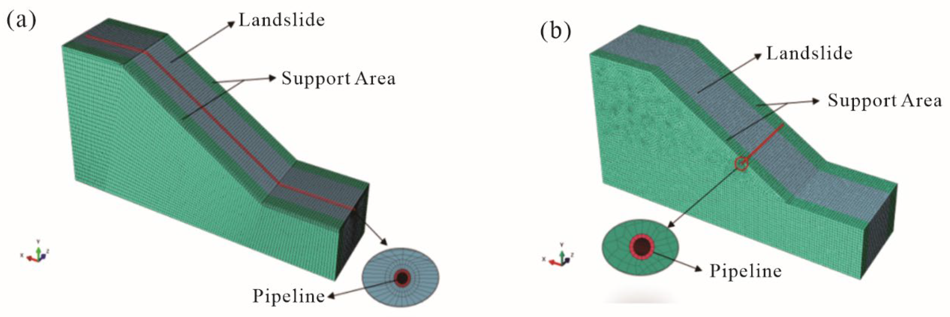
The simulation conditions are shown in Table 1. The main factor affecting the deformation of the pipeline is the additional force exerted on the pipeline. Furthermore, the scale of the landslide and the relative position of the pipeline landslides affects the additional force on the pipeline. Based on the field survey results, the primary geometry characteristic parameters of landslides, which affect the degree of pipeline deformation, were determined and included the width, thickness, slope, and length of the landslide body. The relative position of the pipelines and the landslides consists of two cases: the pipeline crossing the landslide body laterally and the pipeline crossing the landslide body longitudinally. Especially when the pipelines cross the landslides laterally, the locations of pipelines in landslides, including the leading edge, the middle, and the trailing edge of the landslide body, were also considered in the present study. Abaqus was used for simulation. The simulation model of pipeline landslide geological hazards is shown in Figure 2. The mesh size of the pipeline is set as 0.086 m. The mesh sizes of the landslide in length and width are set as 1.5 m and 1.0 m, respectively. The numerical model is simplified based on the actual condition. The terrain, underlying structure, etc. are not considered. The numerical model is only suitable for simple scenarios.

3.2. Simulation Parameters

As shown in Table 2, to quantify the influence of the composition of the body of the material landslide, there are four geotechnical materials in the simulation, which were sampled from field surveys and then attained their basic parameters by the laboratory geotechnical tests. The constitutive models of the pipeline and the soil are the Mohr–Coulomb and Ramberg–Osgood models, respectively. Based on the actual pipeline parameters in the study area and concerning the technical requirements of oil pipeline execution standard “Steel pipe for oil and gas industry pipeline transmission system” (GB/T9711-2011) in China, the pipeline used in this study area is spiral seam submerged arc welded (SSAW) L320 steel pipe. Its physical parameters are shown in Table 3. A gravity of 9.8 m/s2 is applied to all the elements. The pressure inside the pipeline is 2.4 MPa. The z-direction displacement of the left and right planes of the soil is fixed. The x-direction displacement in front and back and all displacement of the bottom of the soil are fixed. At the same time, the z-direction displacement of the pipeline is fixed.

3.3. Simulation Results

There are two pipeline failure criteria: stress criterion and strain criterion. The stress criteria are not applicable in the stage of continuing deformation, in which the stress of pipelines exceeds the point of the proportional limit under landslide disasters. Thus, the strain failure criterion is used in this study. Furthermore, ovality, another strain criterion, is also a standard criterion for judging the failure of pipelines. Therefore, the effect of each influencing factor on the maximum strain and ovality of the pipelines is mainly extracted in this study.

3.3.1. The Pipeline Crossing Landslide Laterally

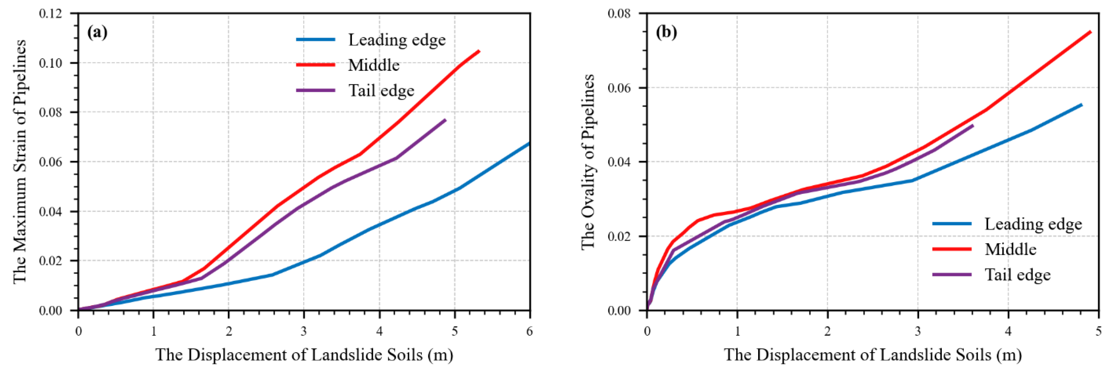
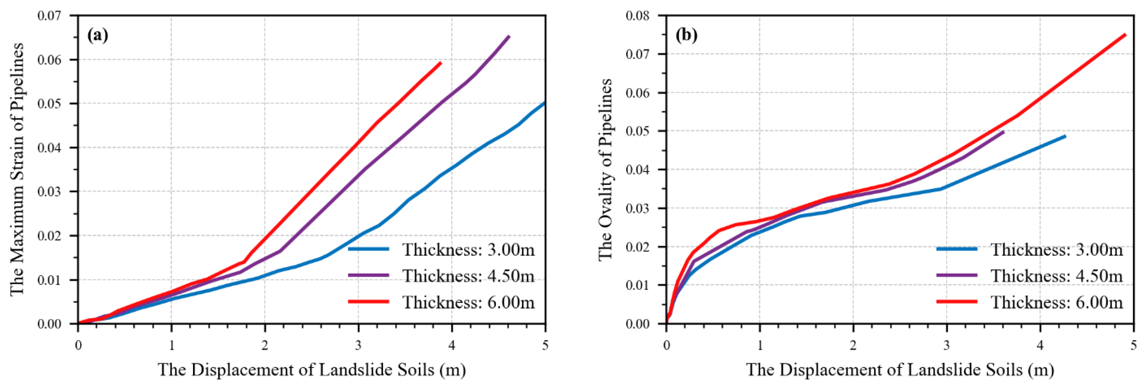
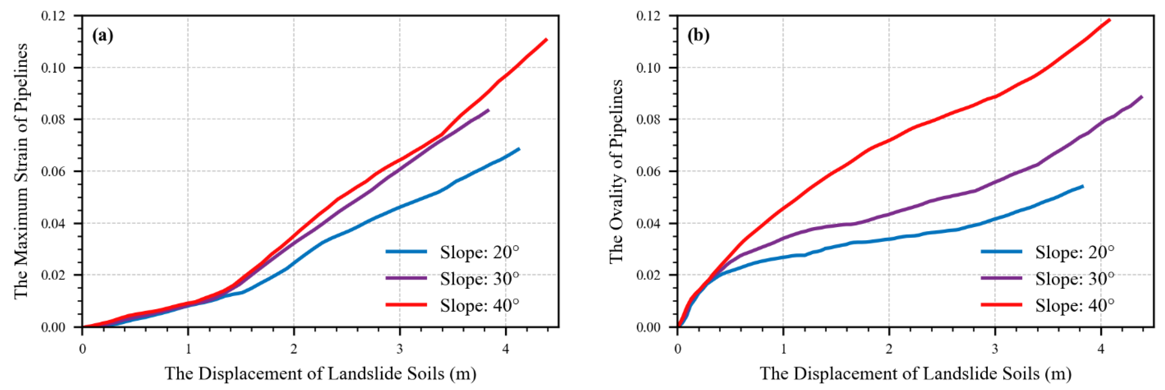
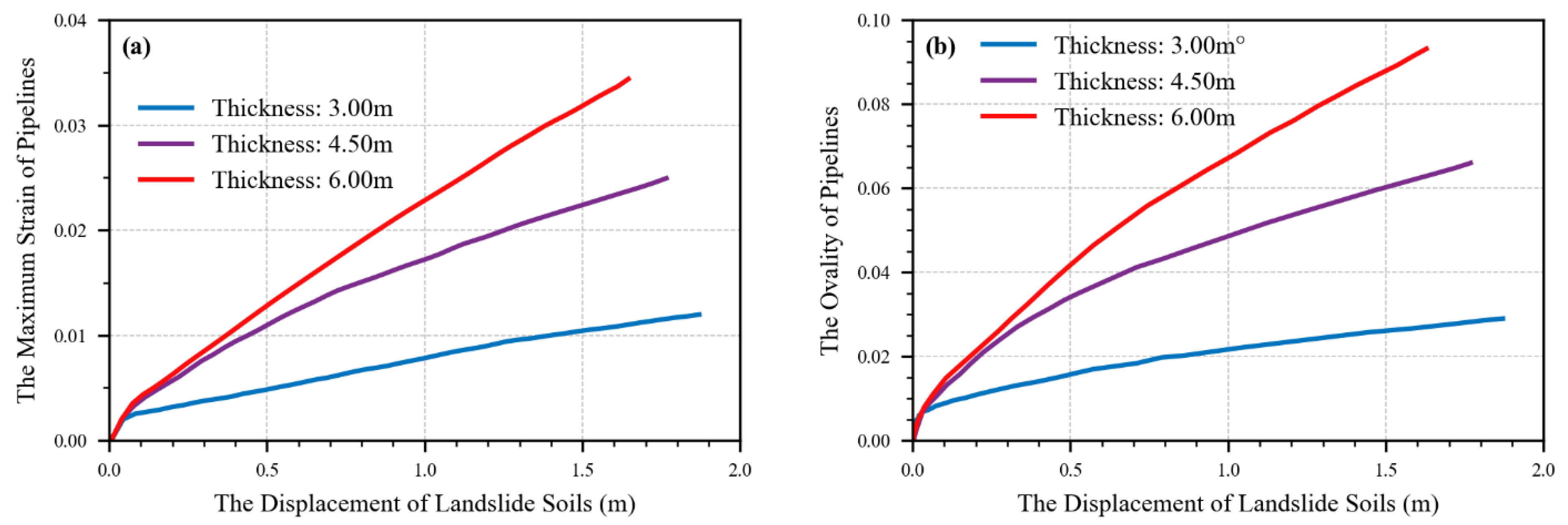
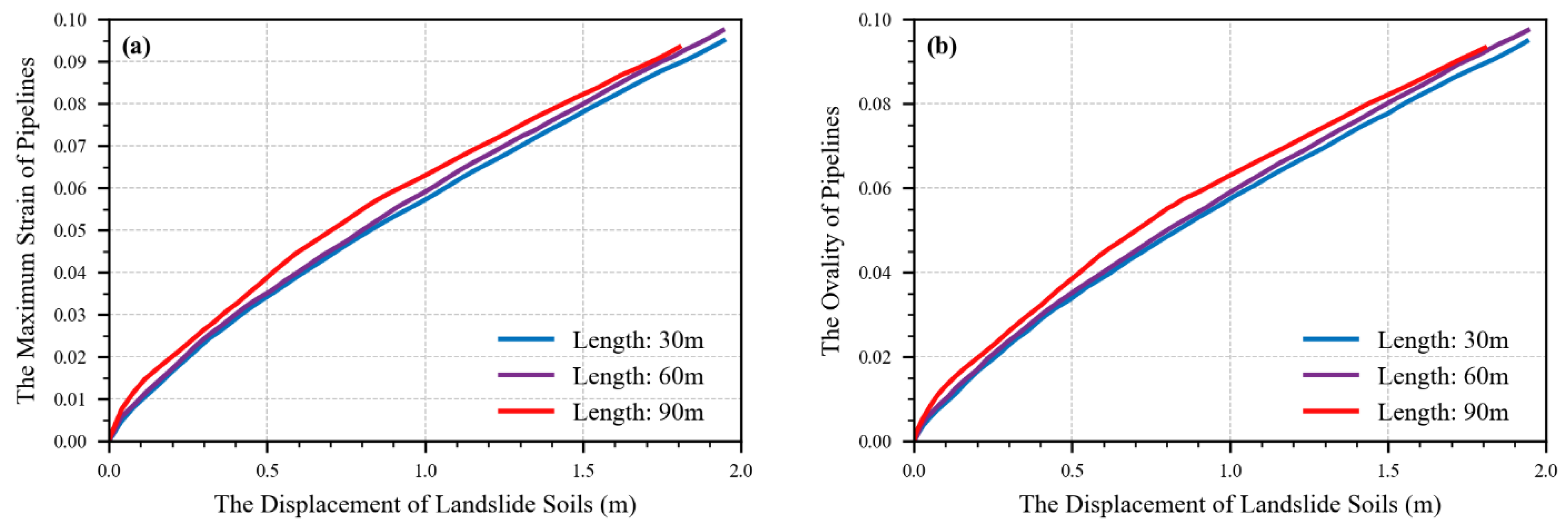
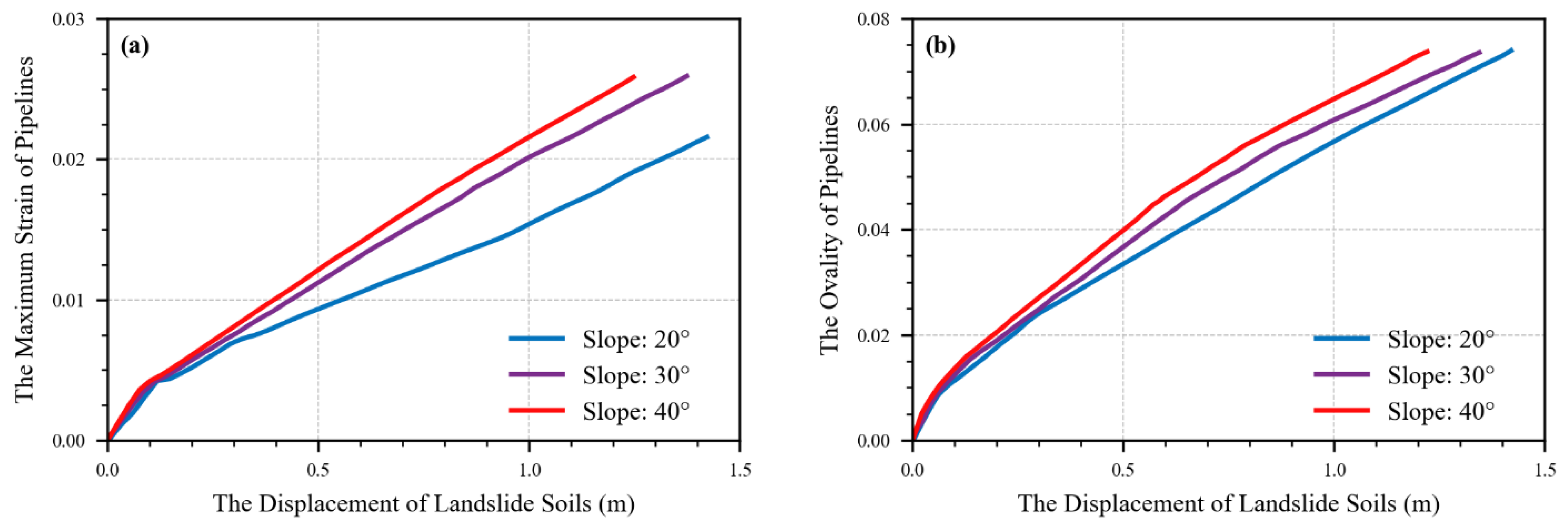
When the pipeline crosses the landslide laterally, the maximum strain and the variation of ovality are extracted when the pipeline was located at different landslides with different thicknesses, widths, lengths, and slopes. Figure 3 shows that with the increase in landslide displacement, the maximum strain and ovality of the pipeline increase. However, the relative locations between landslides and pipelines significantly impact the increased range. The pipeline deformation is the largest when it is located in the middle of the landslide, the second at the trailing edge, and the least when it is located at the leading edge. As shown in Figure 4, Figure 5, Figure 6 and Figure 7, the general rule is that, with the increase of landslide displacement, the maximum strain and ovality of the pipeline increase. Nevertheless, the geometric properties of landslides are controlled by the law of increasing range. As shown in Figure 4, the greater the landslide thickness, the greater the increased range of the maximum strain and ovality of the pipeline. As shown in Figure 5, the more extensive the landslide width, the larger the increased range of the maximum strain and ovality of the pipeline, but the increase is not significant. As shown in Figure 6, the more extensive the landslide length, the larger the increased range of the maximum strain and ovality of the pipeline. As shown in Figure 7, the larger the slope angle of the landslide, the more significant the increase of the maximum strain and ovality of the pipeline, and the increased range of ovality is apparent.

3.3.2. The Pipeline Crossing Landslide Longitudinally

When the pipeline crosses the landslide longitudinally, as in the case of the pipeline crossing the landslide laterally, the maximum strain and the variation of ovality are extracted. However, the influence of the relative positions between pipelines and landslides and the width of the landslide body is not considered because the pipelines are located in the middle of landslides in those cases. As shown in Figure 8, Figure 9 and Figure 10, the general rule is that, with the increase of landslide displacement, the maximum strain and ovality of the pipeline increase. Nevertheless, the growth rate change law are controlled by landslides’ geometric properties. As shown in Figure 8, the greater the landslide thickness, the more significant the increase of the maximum strain and ovality of the pipeline. As shown in Figure 9, the more significant the landslide length, the larger the increase of the maximum strain and ovality of the pipeline, but the increase is not significant. As shown in Figure 10, the more significant the slope angle of the landslide, the larger the increase of the maximum strain and ovality of the pipeline.

3.4. Discussion of Simulation Results

Summarizing the simulation results, the following conclusions can be drawn:
  • Whether the pipe crosses the landslide laterally or longitudinally, the effects of landslide slope, landslide thickness, and landslide length on pipeline deformation are consistent with the same trend, which means that the degree of pipeline deformation is increasing with those variables. It is because both the mass of the unstable soil above the pipe and the unbalance force become larger as these quantities become larger. Thus, the deformation of the pipeline becomes larger.
  • When the pipeline crosses the landslide laterally, it is noticed that the pipeline deformation decreases with the increasing width of the landslide body. The smaller the landslide width is, the more concentrated the strain is, and, therefore, the larger the pipeline deformation is.
  • When the pipeline crosses the landslide laterally, the pipelines are relatively safe at the leading edge of the landslide body, followed by the trailing edge of the landslide body, and are most dangerous in the middle of the landslide body. The unbalanced force is the slightest because the soil at the front edge of the landslide body is supported by the stable soil below. Thus, the deformation of pipelines is minor when the pipeline is located at the front edge of the landslide body. Furthermore, the unstable soil mass carried in the middle of the landslide body is more significant than that at the back edge of the landslide body. Therefore, the pipeline in the middle of the landslide body shows the most significant deformation.

4. Quantitative Impact of Influencing Factors and Early Warning Models

4.1. Quantitative Impact of Influencing Factors

As shown in Equation (1), we reference the derivations of the widely spreading Johnson–Cook dynamic constitutive model [26]. Firstly, the influence of each influencing factor on the pipe deformation is analyzed separately to form the influence function of individual influencing factors. Then the global influence function is obtained by multiplying all the influence functions of each element:
d = K × f ( x 1 ) × f ( x 2 ) × × f ( x n )
where d is the deformation of the pipelines, xn denotes the influence factors, f(xn) is the influence function, the subscript n is the total number of factors, and K is the benchmark data.
Based on the numerical simulation results, the slope, width, thickness, and length of the landslide body were considered the primary influence factors in this study. To guarantee the accuracy of the dimension, dimensionlessization is carried out first. The width of the landslide is the easiest to measure. The width, thickness, length of the landslide, and the deformation of the pipe are divided by the width of the landslide to carry out the dimensionlessization, respectively. Thus, the influences function modified by the dimensionlessization is:
d w = f ( A ) × f ( D W ) × f ( L w ) × K W
where A is the slope of the landslide body, w is the width of the landslide body, D is the thickness of the landslide body, L is the length of the landslide, K is the base data, and f(x) is the influence function. Take the pipe deformation data with 90° slope, 30 m width, 30 m thickness, and 30 m length of landslide body as the base data. Equation (2) can be written as:
f ( 90 ) × f 30 30 × f 30 30 × 1 30 = 1
To further analyze the difference between each data and the benchmark data, the influence coefficient of each data was obtained by fitting the regression algorithm. Then the influence function of each influence factor can be fitted by the method of fixed coefficient. Finally, the ultimate influence functions are listed in Table 4 and Table 5.

4.2. Discussion of the Early Warning Models

Based on the derived influence function, the dimensionless parameters of the pipeline’s maximum strain, ovality, and safety coefficient are calculated. The state of landslides was obtained by multiplying the deformation of the landslides and the function of the influence factors. Then the relationship between the state of landslides and these three dimensionless parameters above was illustrated, as shown in Figure 11. According to the curves, the piecewise early warning models are proposed for the pipeline landslides hazards for the pipelines crossing the landslides laterally and longitudinally, respectively. They will be introduced in the next paragraph.
As shown in Figure 11a: (1) when the normalized soil displacement reaches 0.016, the safety coefficient of the landslide soil decreases abruptly, and the maximum strain and ovality of the pipelines change linearly with the normalized soil displacement of the landslides. However, the maximum strain and the variation of ovality are both still less than the threshold value, and the safety coefficient of the landslide exceeds 1.05, which demonstrates that the shear strength of the landslide soil is greater than the sliding strength, so the landslide is kept in a stable state. In this situation, the pipeline behaves with a certain degree of deformation characteristics, but the possibility of damage and then leakage of the pipeline located in the landslide area is minimal; thus, the warning level is the attention level. (2) When the normalized soil displacement reaches 0.03, the maximum strain and the ovality of the pipeline increase with the variation rate of the normalized soil displacement, and the soil safety coefficient continues to decrease and closes to the under-stable state, which is when the safety coefficient is below 1.05. It is during this time that the pipelines have prominent deformation characteristics. The possibility of the damage leading to leakage of pipelines buried in the landslide zones is still slight. Therefore, the warning level is the caution level. (3) As the normalized soil displacement reaches 0.05, the safety coefficient of the landslide is less than 1.05, which means that the landslide is in an under-stable state. In this case, the ovality of the pipe has reached the threshold, but the maximum strain of the pipelines still does not reach the point of destabilization. Thus, the warning level is the alarm level. (4) As the normalized soil displacement reaches 0.077, the landslide is in an under-stable state, with its safety coefficient being less than 1.05. The ovality of the pipeline reaches the specified threshold, but the maximum strain of the pipeline exceeds about 3% of the set strain threshold and keeps continuously increasing. According to the “Gas Transmission Pipeline Engineering Design Regulations” in China, the pipeline is currently in an unstable and damaged state; there is a huge possibility that the damage leads to leakage of the pipeline located in the landslide zone; meanwhile, various short-term precursor features are apparent. Naturally, the warning level is the catastrophe level.
As shown in Figure 11b: (1) when the normalized soil displacement reaches up to 0.25, the safety coefficient of the landslide decreases abruptly. The maximum strain and the variation of ovality change linearly with the normalized soil displacement of the landslide. However, the maximum strain and the variation of ovality are more minor than the set threshold value. The safety coefficient of the landslide is more significant than 1.05, so the shear strength of the landslide soil is greater than the sliding strength, and the landslide is in a stable state. Though the pipeline has a minor deformation characteristic, the possibility of damage and leakage is slight for the pipeline buried in the landslide areas. So the warning level is the attention level. (2) When the normalized soil displacement climbs up to 0.5, the maximum strain and the variation of ovality increase with the normalized soil displacement’s change rate, and the landslide safety coefficient continues to reduce and approaches the unstable state (FS < 1.05). At this moment, the pipeline performs a recognizable degree of deformation along with the deformation of landslide soil. Damage and leakage are less likely to occur. Therefore, the warning level is the caution level at this stage. (3) With the normalized soil displacement continuously increasing to 0.65, the safety coefficient of the landslide is lower than 1.05, and the landslide is in an unstable state. The ovality of the pipeline is close to the threshold. However, the maximum strain of the pipeline is still under the set threshold value. Thus, the warning level is the alarm level. (4) As the normalized soil displacement remains increasing to 1.3, the landslide is in the unstable stage (FS < 1.05). At this time, the ovality of the pipeline has gone beyond the set threshold value, and the max strain of the pipeline also exceeds over 3% of the threshold of strain with an accelerating trend. According to the “Gas Transmission Pipeline Engineering Design Regulations” in China, the pipeline is currently in an unstable and damaged state; there is a huge possibility that the damage leads to leakage of the pipeline located in the landslide zone; meanwhile, various short-term precursor features are apparent. Naturally, the warning level is the catastrophe level.
When landslide disasters occur, the existing warning model of pipeline landslides based on the single state of pipelines is too sluggish to respond. Due to lacking enough emergency time, pipeline deformation and even damage may occur promptly. The existing warning model based on the deformation progress of the body of the landslide is too conservative because the pipeline may still keep a stable state under the movement of landslides. However, the warning model proposed by the present study combines the advantages of the above two types of warning models and considers the landslide state, the safety coefficient of landslides, and the state of the pipeline itself. It can remarkably improve the accuracy of early warning, reduce the probability of false or missed forecasts, and guarantee the safe operation of the pipeline network.

5. Conclusions

  • Through a field investigation, we found that the scale of landslides, including the length, width, slope, and thickness, and the relative position of the pipeline landslide are the main factors determining the deformation of pipelines induced by landslides. The degree of the pipeline’s deformation was determined by the relative position between the pipeline’s location and the landslide and the landslide scale.
  • Based on numerical simulation, no matter whether the pipeline crosses the landslide laterally or longitudinally, with the increase of the landslides’ angles, thicknesses, and lengths, the deformation characteristic of pipelines appears almost identical. The deformation of pipelines keeps continues to increase. The smaller the landslide width is, the more concentrated the strain is, and therefore, the larger the pipeline deformation is.
  • When the pipelines cross the landslides laterally, the deformation of pipelines reduces with the broadening of the width of landslides, it is safer for the pipelines buried in the leading edge of landslides than the tail edge, and it is most dangerous when the pipelines are located in the middle of landslides.
  • Considering the variation of the scale, a piecewise forewarning model including multiple parameters was established based on the influence function for crossing pipelines in landslides.
The proposed forewarning model can be beneficial to monitoring and evaluating landslide geological disasters of pipelines and effectively reduce the risk of pipeline landslide geological hazards in the monitored area. It can provide a fundamental basis for adopting prevention and control measures of pipeline landslide geological hazards and protect the safety of pipeline operations.

Author Contributions

Conceptualization, P.N. and Y.-j.J.; methodology, J.-j.T. and Q.-j.X.; software, J.-j.T.; investigation, J.-j.T.; writing—original draft preparation, P.N. and J.-j.T.; writing—review and editing, P.N., Y.-j.J. and Q.-j.X.; supervision, Y.-j.J. and Q.-j.X.; funding acquisition, P.N. and Y.-j.J. All authors have read and agreed to the published version of the manuscript.

Funding

This research was funded by International Science & Technology Cooperation Program of China grant number 2018YFE0100100 and National Natural Science Foundation of China grant number 12202465.

Data Availability Statement

Data not available due to legal restrictions. Due to the nature of this research, participants of this study did not agree for their data to be shared publicly, so supporting data is not available.

Acknowledgments

The authors also thank the reviewers for their helpful comments and suggestions.

Conflicts of Interest

The authors declare no conflict of interest.

Abbreviations

InSARInterferometric synthetic aperture radar
FBGFiber Bragg grating
SSAWSteel pipe of spiral seam submerged arc welded
ILDTsIn-line device technologies
TTBTsTransient test-based techniques
ρDensity
EElastic modulus
φInternal friction
CCohesive force
DOutside diameter of the pipeline
TThickness of pipeline
μPoisson’s ratio
σSMinimum yield strength
dDeformation of pipeline
xnInfluence factor
f(xn)Influence function
KBenchmark data
ASlope of the landslide body
wWidth of the landslide body

References

  1. Bekaert, D.P.S.; Handwerger, A.L.; Agram, P.; Kirschbaum, D.B. InSAR-Based Detection Method for Mapping and Monitoring Slow-Moving Landslides in Remote Regions with Steep and Mountainous Terrain: An Application to Nepal. Remote Sens. Environ. 2020, 249, 111983. [Google Scholar] [CrossRef]
  2. Ding, C.; Feng, G.; Liao, M.; Tao, P.; Zhang, L.; Xu, Q. Displacement History and Potential Triggering Factors of Baige Landslides, China Revealed by Optical Imagery Time Series. Remote Sens. Environ. 2021, 254, 112253. [Google Scholar] [CrossRef]
  3. Liu, Z.; Qiu, H.; Ma, S.; Yang, D.; Pei, Y.; Du, C.; Sun, H.; Hu, S.; Zhu, Y. Surface Displacement and Topographic Change Analysis of the Changhe Landslide on September 14, 2019, China. Landslides 2021, 18, 1471–1483. [Google Scholar] [CrossRef]
  4. Pei, Y.; Qiu, H.; Yang, D.; Liu, Z.; Ma, S.; Li, J.; Cao, M.; Wufuer, W. Increasing Landslide Activity in the Taxkorgan River Basin (Eastern Pamirs Plateau, China) Driven by Climate Change. CATENA 2023, 223, 106911. [Google Scholar] [CrossRef]
  5. Liu, Z.; Qiu, H.; Zhu, Y.; Liu, Y.; Yang, D.; Ma, S.; Zhang, J.; Wang, Y.; Wang, L.; Tang, B. Efficient Identification and Monitoring of Landslides by Time-Series InSAR Combining Single-and Multi-Look Phases. Remote Sens. 2022, 14, 1026. [Google Scholar] [CrossRef]
  6. Wang, L.; Qiu, H.; Zhou, W.; Zhu, Y.; Liu, Z.; Ma, S.; Yang, D.; Tang, B. The Post-Failure Spatiotemporal Deformation of Certain Translational Landslides May Follow the Pre-Failure Pattern. Remote Sens. 2022, 14, 2333. [Google Scholar] [CrossRef]
  7. Zhou, W.; Qiu, H.; Wang, L.; Pei, Y.; Tang, B.; Ma, S.; Yang, D.; Cao, M. Combining Rainfall-Induced Shallow Landslides and Subsequent Debris Flows for Hazard Chain Prediction. Catena 2022, 213, 106199. [Google Scholar] [CrossRef]
  8. Yin, Y.; Zheng, W.; Liu, Y.; Zhang, J.; Li, X. Integration of GPS with InSAR to Monitoring of the Jiaju Landslide in Sichuan, China. Landslides 2010, 7, 359–365. [Google Scholar] [CrossRef]
  9. Meniconi, S.; Capponi, C.; Frisinghelli, M.; Brunone, B. Leak Detection in a Real Transmission Main through Transient Tests: Deeds and Misdeeds. Water Resour. Res. 2021, 57, e2020WR027838. [Google Scholar] [CrossRef]
  10. Meniconi, S.; Cifrodelli, M.; Capponi, C.; Duan, H.-F.; Brunone, B. Transient Response Analysis of Branched Pipe Systems toward a Reliable Skeletonization. J. Water Resour. Plan. Manag. 2021, 147, 04020109. [Google Scholar] [CrossRef]
  11. Shuai, J.; Wang, X.L.; Zuo, S.Z. Breakage Action and Defend Measures to Pipeline under Geological Disaster. Welded Pipe Tube 2008, 31, 9–15. [Google Scholar]
  12. Zahid, U.; Godio, A.; Mauro, S. An Analytical Procedure for Modelling Pipeline-Landslide Interaction in Gas Pipelines. J. Nat. Gas Sci. Eng. 2020, 81, 103474. [Google Scholar] [CrossRef]
  13. Tsatsis, A.; Gazetas, G.; Kourkoulis, R. Pipeline Response under Landslide Action. Geohazards Pipelines 2021, 107–121. [Google Scholar] [CrossRef]
  14. Deng, D.M.; Zhou, X.H.; Shen, Y.P. Calculation of Pipeline Inner Force and Distortion during Transverse Landslide Body. Oil Gas Storage Transp. 1998, 17, 18–22. [Google Scholar]
  15. Pei, H.; Cui, P.; Yin, J.; Zhu, H.; Chen, X.; Pei, L.; Xu, D. Monitoring and Warning of Landslides and Debris Flows Using an Optical Fiber Sensor Technology. J. Mt. Sci. 2011, 8, 728–738. [Google Scholar] [CrossRef]
  16. Rajani, B.B.; Robertson, P.K.; Morgenstern, N.R. Simplified Design Methods for Pipelines Subject to Transverse and Longitudinal Soil Movements. Can. Geotech. J. 1995, 32, 309–323. [Google Scholar] [CrossRef]
  17. Sarvanis, G.C.; Karamanos, S.A. Analytical Model for the Strain Analysis of Continuous Buried Pipelines in Geohazard Areas. Eng. Struct. 2017, 152, 57–69. [Google Scholar] [CrossRef]
  18. Chan, P.D.S. Soil-Pipe Interaction in Slopes. Master’s Thesis, University of Calgary, Calgary, AB, Canada, 1999. [Google Scholar] [CrossRef]
  19. Challamel, N.; de Buhan, P. Mixed Modelling Applied to Soil-Pipe Interaction. Comput. Geotech. 2003, 30, 205–216. [Google Scholar] [CrossRef]
  20. Zhang, D.C.; Bykov, L.I. The Force-Summing Analysis of Buried Pipeline under Landslide Condition. Pet. Plan. Eng. 2001, 12, 1–3. [Google Scholar]
  21. Bruschi, R.; Spinazze, M.; Tomassini, D.; Cuscuna, S.; Venzi, S. Failure Modes for Pipelines in Landslide Areas; American Society of Mechanical Engineers: New York, NY, USA, 1995. [Google Scholar]
  22. Bruschi, R.; Glavina, S.; Spinazze, M.; Tomassini, D.; Bonanni, S.; Cuscuna, S. Pipelines Subject to Slow Landslide Movements: Structural Modeling vs. Field Measurement; American Society of Mechanical Engineers: New York, NY, USA, 1996. [Google Scholar]
  23. Zhang, Y.; Wang, Z.; Yang, Q.; Wang, H. Numerical Analysis of the Impact Forces Exerted by Submarine Landslides on Pipelines. Appl. Ocean Res. 2019, 92, 101936. [Google Scholar] [CrossRef]
  24. Zheng, J.Y.; Zhang, B.J.; Liu, P.F.; Wu, L.L. Failure Analysis and Safety Evaluation of Buried Pipeline Due to Deflection of Landslide Process. Eng. Fail. Anal. 2012, 25, 156–168. [Google Scholar] [CrossRef]
  25. Yan, Y.; Yang, D.S.; Geng, D.X.; Hu, S.; Wang, Z.A.; Hu, W.; Yin, S.Y. Disaster Reduction Stick Equipment: A Method for Monitoring and Early Warning of Pipeline-Landslide Hazards. J. Mt. Sci. 2019, 16, 2687–2700. [Google Scholar] [CrossRef]
  26. Umbrello, D.; M’Saoubi, R.; Outeiro, J.C. The Influence of Johnson-Cook Material Constants on Finite Element Simulation of Machining of AISI 316L Steel. Int. J. Mach. Tools Manuf. 2007, 47, 462–470. [Google Scholar] [CrossRef]
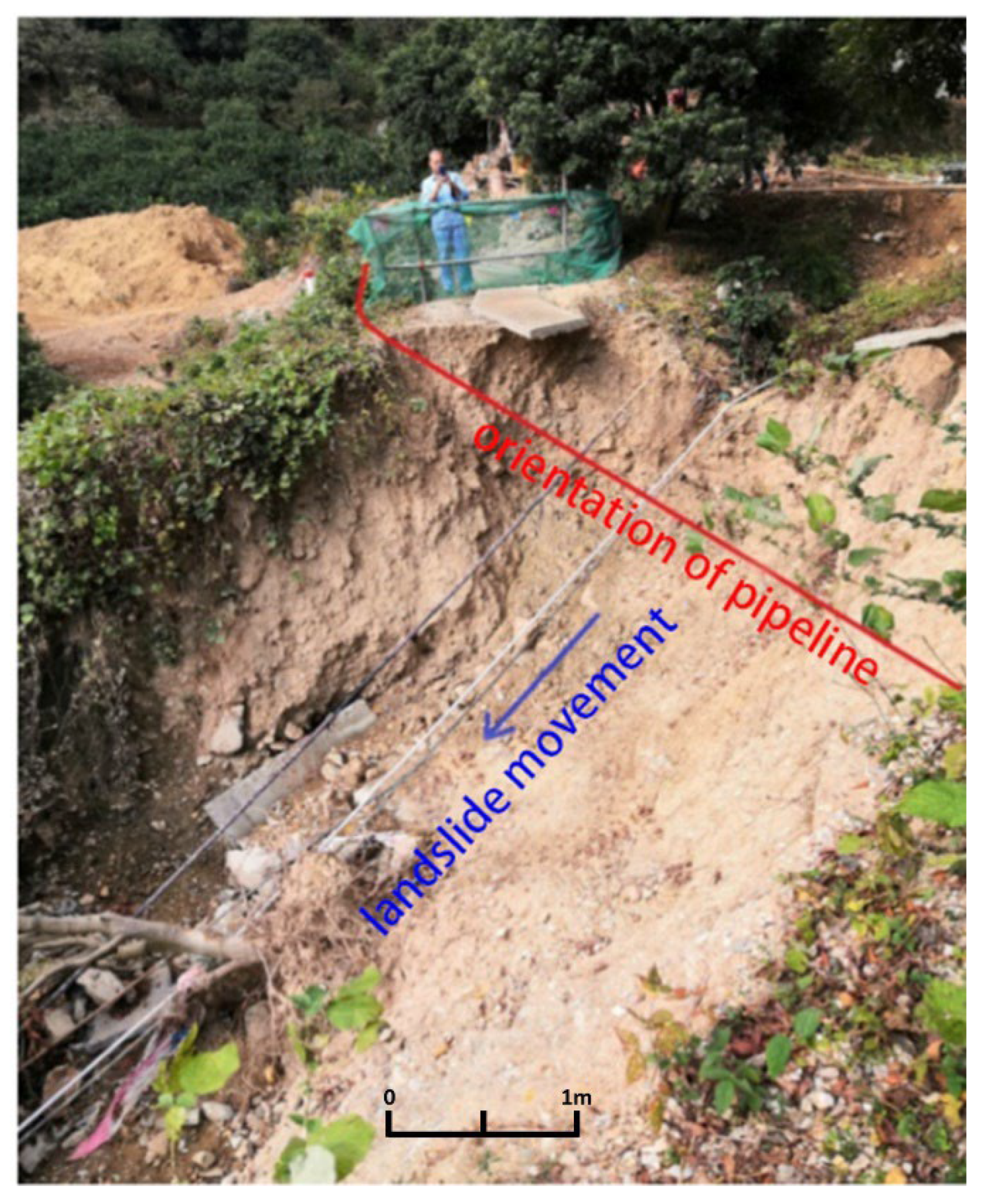
Figure 1. One example of the field survey of a landslide along the pipeline in the southeast areas of China.
Water 15 00693 g001
Figure 2. Model configuration: (a) pipeline crossing landslide laterally; (b) pipeline crossing landslide longitudinally.
Water 15 00693 g002
Figure 3. The influences of relative locations between landslide and pipeline (laterally): (a) the maximum strain; (b) the variation of ovality.
Water 15 00693 g003
Figure 4. The influences of thickness of the main landslide body (laterally): (a) the maximum strain; (b) the variation of ovality.
Water 15 00693 g004
Figure 5. The influences of the width of the main landslide body (laterally): (a) the maximum strain; (b) the variation of ovality.
Water 15 00693 g005
Figure 6. The influences of the length of landslide the main body (laterally): (a) the maximum strain; (b) the variation of ovality.
Water 15 00693 g006
Figure 7. The influences of the slope of landslide (laterally): (a) the maximum strain; (b) the variation of ovality.
Water 15 00693 g007
Figure 8. The influences of thickness of landslide (longitudinally): (a) the maximum strain; (b) the variation of ovality.
Water 15 00693 g008
Figure 9. The influences of the length of landslide (longitudinally): (a) the maximum strain; (b) the variation of ovality.
Water 15 00693 g009
Figure 10. The influences of the slope of landslide (longitudinally): (a) the maximum strain; (b) the variation of ovality.
Water 15 00693 g010
Figure 11. Schematic diagram of early warning model: (a) pipeline crossing landslide horizontally; (b) pipeline crossing landslide vertically.
Water 15 00693 g011
Table 1. Program of numerical simulation.
CategoryValue
landslidewidth (m)30/40/50
thickness (m)3/4.5/6
slope (°)20/30/40
length (m)30/60/90
relative location of the pipelinepipeline crossing landslide laterallyleading edge/middle/tail edge
pipeline crossing landslide longitudinallymiddle
Table 2. The material parameters of slope soil.
MaterialsStateDensity
ρ (kg/m³)
Elastic Modulus
E (MPa)
Poisson’s Coefficient μInternal
Friction φ (°)
Cohesive Force
C (kPa)
Landslide bodysaturated2360200.3515.013.0
Support areanatural1980200.318.025.0
Basement of slope/26005.56 × 1040.2335.026.0
Table 3. The material parameters of the pipeline.
ItemValueItemValue
Steel typesL320Outside diameter
D (mm)
610
Elastic modulus E (MPa)2.1 × 10⁵Thickness
T (mm)
7.9
Poisson’s ratio
μ
0.25Minimum yield strength
σS (MPa)
320
Density
ρ (kg/m3)
7800
Table 4. The influence function of impact factors when the pipeline crosses the landslide laterally.
CategoryFunction
Relative locationNot considering other influence factors, the deformation degree of the pipeline in the middle of the landslide is 1.6 times at the leading edge of the landslide, and the deformation degree of a pipeline at the tail edge is 1.4 times at the leading edge
Slopes of landslide 0.6 + 0.01 × A
Thickness of landslide 0.1 + 13.05 × D W 40.05 × ( D W ) 2
Lengths of landslide 0.7 + 0.1 × L W
Global influence function ( 0.6 + 0.01 × A ) × ( 0.1 + 13.05 × D W 40.05 × ( D W ) 2 ) × ( 0.7 + 0.1 × L W ) × K W = d W
Table 5. The influence function of impact factors when the pipeline crosses the landslide longitudinally.
CategoryFunction
Slopes of landslide 0.45 A + 5 × 10 4 A 2
Thickness of landslide 0.475 0.25 D W
Lengths of landslide 0.7 + 6 × 10 3 L W 2.8 × 10 5 ( L W ) 2
Global influence function ( 0.45 A + 5 × 10 4 A 2 ) × ( 0.475 0.25 D W ) × ( 0.7 + 6 × 10 3 L W 2.8 × 10 5 ( L W ) 2 ) × K W = d W
Disclaimer/Publisher’s Note: The statements, opinions and data contained in all publications are solely those of the individual author(s) and contributor(s) and not of MDPI and/or the editor(s). MDPI and/or the editor(s) disclaim responsibility for any injury to people or property resulting from any ideas, methods, instructions or products referred to in the content.