Abstract
In this article we present the first investigation of the stable isotope composition of groundwater in Romania, East-Central Europe, with a focus on the karst areas. Our aim is twofold: (1) to provide a countrywide map with the distribution of stable oxygen and hydrogen isotope ratios in groundwater, and (2) to assess the recharge patterns of karst water. We collected more than 600 water samples from springs and wells across Romania for stable isotope analyses and monitored in detail the stable isotope composition of the waters as they pass through five cave systems. Our data show a spatial distribution of the stable isotope composition of the groundwater with low values in the mountainous area and high values in the surrounding lowlands and the central Transylvanian Depression. However, waters in karst areas induce departures from this distribution, resulting from the fast (hours to days) transfer of waters from high (ponor) to low (spring) altitudes. Water emerging from the karst springs has generally lower δ values than before sinking through the ponors, thus indicating a substantial contribution of winter recharge through diffuse infiltration and seepage. This contribution results in overall dilution of the water entering through ponors, likely resulting in changes in the chemical composition of the water and diluting potential pollutants. Our data call for careful separation between karst and non-karst spring/well waters, as indiscriminate common treatment might lead to erroneous interpretations.
1. Introduction
Groundwater is one of the main sources of public water supplies across the globe and is also an important resource for agriculture and industry. Understanding the source, age and recharge patterns of groundwater is one of the first steps towards ensuring the right of all humans to clean water and sanitation (EEA), one of the sustainable development goals (SDG 6) adopted by the United Nations [1]. About 25% of the groundwater used globally is sourced from karst springs, i.e., springs draining karstified rocks (mainly limestone and dolomite), with several large cities (e.g., London, Paris, Rome) relying completely or partly on karst waters [2]. Contrary to porous aquifers, water in karst regions mainly flows through secondary (fractures) and tertiary (conduits, or caves) pores, and thus its flow characteristics are strongly controlled by the characteristics of the terrain [3]. One of the consequences of this contrast in flow characteristics is the relative homogenization of the oxygen and hydrogen stable isotope composition of groundwater in porous rocks, while in karstified rocks the homogenization is less evident, due to the fast transfer of surface runoff in the underground [4,5]. The heterogeneity of karstic aquifers leads to difficulties in understanding the source, recharge patterns, age and availability of these waters [6].
In Romania (Eastern Europe), the Carpathian Mountains act as a large water tower, with virtually all surface and shallow groundwater being derived from “captured“ precipitation. Previous studies have shown a large variability in the stable isotopic composition of both precipitation [7] and groundwater [8], resulting from a strong interplay between moisture sources, atmospheric circulation patterns and orography. However, the groundwater study was restricted to a small area in the northern Carpathian Mountains, and it did not include karstified areas.
While karst terrains are limited to less than 3% of the country’s area, they harbour numerous rural settlements exclusively supplied with drinking water from karst aquifers. Several of these areas can be found in touristic hot-spots and the recent increase in touristic activity continuously strains the already limited water resources. In this context, our research objective was to investigate the recharge patterns of several karst springs in Romania and provide a stable isotope-based tool for future similar studies. Therefore, we provide here insights into the dynamics of water flow through several karst systems in NW Romania using the ratios of oxygen and hydrogen stable isotopes as tracers, one of most powerful hydrogeological and hydrological tools available [9,10]. The results of the stable isotope analyses of karst waters are analysed in conjunction with similar data from precipitation, rivers and groundwater in Romania. As part of our work, we also provide the first overall map of δ18O distribution in groundwaters in Romania, as a potential tool for future hydrologic and also provenance studies.
2. Site Description, Materials and Methods
2.1. Site Description
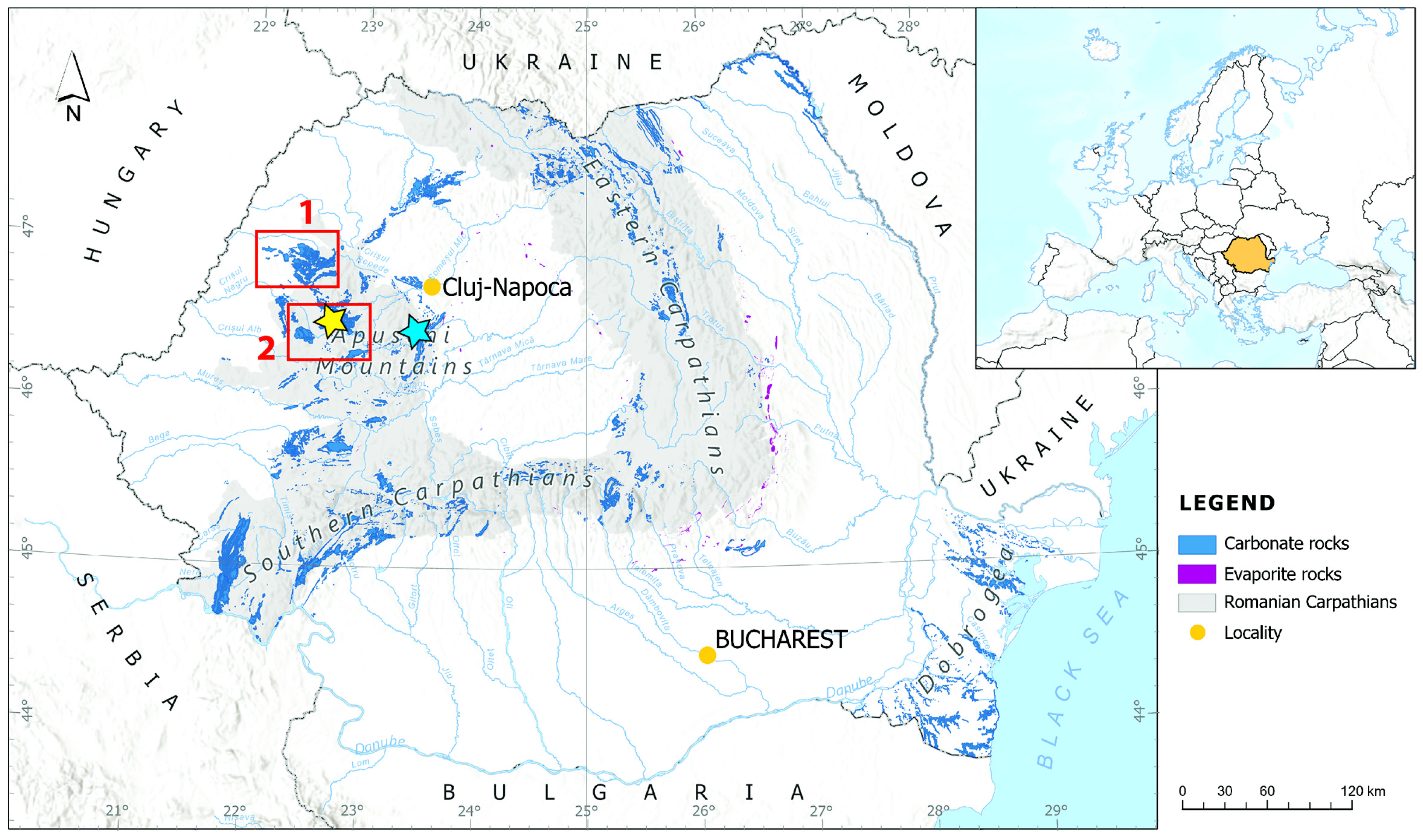
Karst rocks (mainly limestone) outcrop over ~5500 km2 in Romania and are mostly found in the Carpathian Mountains (Figure 1), but they are also present below Pliocene and Quaternary deposits in the eastern and south-eastern regions of the country [11]. The greatest concentration of caves is in the Apuseni Mountains, developed mostly in Jurassic and Cretaceous limestones. For this study, we have investigated five karst systems located in the NW Apuseni Mountains (Figure 1), namely in the Pădurea Craiului Mountains (three systems) and Bihor Mountains (two systems) and one system located in the Trascău Mountains (Figure 1). The investigated caves from the Pădurea Craiului Mountains are carved in Neocomian–Lower Aptian (Lower Cretaceous) limestones, deposited on top of Oxfordian–Lower Tithonian (Upper Jurassic) reefal limestones, the two units being separated by an intensively karstified paleosurface [11]. The two systems in the Bihor Mountains developed in thickly bedded Kimmeridgian limestones, while Huda lui Păpară Cave formed in Tithonian limestone, both deposited in the Upper Jurassic.
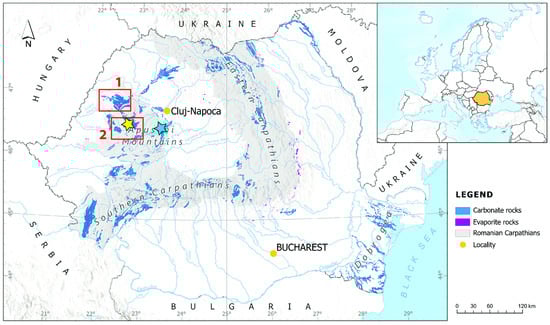
Figure 1.
Location of the sampling sites. The red rectangles show the location of sampling sites in the Pădurea Craiului Mountains (1) and Bihor Mountains (2); the yellow star marks the position of the precipitation sampling station, and the blue star marks the location of water sampling. Huda lui Păpară Cave is located just south of the blue star.
The five investigated karst systems are described below, and their main characteristics are shown in Table 1.
The Peştera lui Potriva–Peştera de la Aştileu (Pădurea Craiului Mountains) system is formed along the Mniera Valley, which drains a 1.5 km long flat-bottomed karst depression covered by thick alluvium before sinking into Peștera lui Potriva. The entrance of the karst system (5–6 m high and 17 m wide) is located at the base of a 10 m limestone outcrop and gives access to a 3713 m long cave. The upper section of the cave is fossil, and its galleries descend towards the active stream which is intercepted at several points, separated by slums. The water passes through several lakes before disappearing into an impassable sump. Following a yet unexplored 2620 m long underwater passage, the waters emerge in Aștileu Cave, some 107 m below the lowest point in Peştera lui Potriva. Aștileu Cave (5080 m long) is a typical water table cave [12,13], with a mean discharge of 356 L/s (varying between 74 and 3410 L/s) and a base flow index (defined as the ratio between the monthly mean discharge of the driest month and the mean annual discharge [13]) of 0.303. While the main source of water emerging through Aștileu Cave is the river sinking into Peștera lui Potriva, minor contributions are provided by losses through several ponors along small streams (the Poienii and Peștișului) located between the two caves. The entire watershed of Aștileu Cave is 106 km2, of which only 19 km2 is exclusive to the cave, the remaining being shared with several other, smaller, springs [12]. The average speed of water moving from ponor (Peștera lui Potriva) to spring (Aștileu Cave) is 262.2 m/h, resulting in a 10 h transfer time between the two.

Table 1.
Main characteristics of the studied karst systems (data from Orășeanu and Iurkiewicz, 2010 [13]).
Table 1.
Main characteristics of the studied karst systems (data from Orășeanu and Iurkiewicz, 2010 [13]).
| Karst System | Length (m) | Altitude Difference (m) | Flow Time (h) |
|---|---|---|---|
| Potriva Cave–Aștileu Cave (POT-AST) | 2620 | 107 | 10 |
| Gălășeni Cave–Josani Spring (GAL-JOS) | 1750 | 95 | 13 |
| Toaie Ponor–Dămișenilor Spring (TOA-DAM) | 3550 | 255 | 90 |
| Ocoale Valley–Cotețul Dobreștilor (OCO-COT) | 2800 | 390 | 38 |
| Vuiagă well–Poliței Spring (VUI-POL) | 1360 | 225 | 10 |
The Peştera de la Gălăşeni–Izbucul Groapa Moţului de la Josani (Pădurea Craiului Mountains) system is formed as the Deblei stream sinks underground into the ~2500 m long Gălășeni Cave. The active cave passage ends in a sump after 100 m, the water emerging 95 m below and 1750 m away through several small springs, of which the Josani is the largest [12]. Along the way, the water sinking into Gălășeni Cave receives a small tributary, which contributes water from a small ponor to the overall water balance of the spring. Dye tracing (fluorescein) gives a sort (13 h) transit time, with an average speed of 134.8 m/h.
The Toaie Ponor–Peștera Izbucul Dămișenilor system is the longest (3550 m, straight line between the end points) and deepest (255 m between the altitude of the end points) of the five investigated karst systems [12]. It forms as the waters of a small stream sink underground through a ponor at the base of a 25 m high limestone wall dotted with fossil cave entrances closing the Damiș karstic depression. The emergence is through four springs, two temporarily active and two permanent, of which the largest continues through the Izbucul Dămișenilor, a 2810 m long water table cave. Along the route, the system receives water from two small tributaries. The cave can be accessed only by diving in a short (between 10 and 25 m long, depending on discharge) sump which gives access to a long, narrow and meandering passage, dotted by four large rooms, partly filled with sediments transported and deposited by the river. Several small tributaries bring additional water to the main passage, but these are small, compared to the main source—the sinking stream at Toaie Ponor. The discharge at Izbucul Dămișenilor is low (82 m/s), varying between 28 and 519 L/s), with a base flow index of 0.361, close to that of the Peştera lui Potriva–Peştera de la Aştileu system. The length of the hydrological connection between the ponor and the spring is 3550 m and the altitude difference is 255 m [13]. Fluorescein dye tracing indicates a transit time of 90 h, with an average speed of 39.5 m/h, very slow compared to the other systems investigated here.
The Ocoale–Dobrești system drains the Ocoale Depression, a small contact karst depression formed between Upper Jurassic sandstones and Middle Jurassic limestones. At the contact point between the two units, several ponors have formed, with the lowest being inactive and the middle ones activating only during floods induced by spring rains and snow melt. The water sinking into the ponors emerges 770 m below, through the ~400 m long vauclausian Izbucul de la Cotețul Dobreștilor spring (~67 m deep). Before sinking, the Ocoale valley collects water from springs and small brooks draining into a shallow surface aquifer stored in sands overlaying the limestone bedrock, as well as several small karst springs. The length of the underground, unexplored passages between the ponors and the spring is 2800 m and the altitude difference is 390 m. Fluorescein dye tracing [13] indicates a velocity of 73.7 m/h between the two and an average transfer time of 38 h. The Izbucul de la Cotețul Dobreștilor spring is the overflow of the system, with the permanent outflow located several meters below, at Izbucul Morii. Izbucul de la Cotețul Dobreștilor also receives water from temporary losses along the Ordâncușa River, the two being connected via a 2900 m long yet-unexplored passage. The transfer time along this secondary connection is low (90 h) resulting from a very low flow velocity (32 m/h), likely along phreatic passages. The drainage area of the permanent source (Ocoale ponors) is 8.2 km2. The discharge at Izbucul de la Cotețul Dobreștilor ranges between 0 and 2120 L/s, with an average value of 274.7 L/s and a maximum monthly flow rate of 1.06 m3/s [13]. The base flow index is extremely low, at 0.03 (the lowest in this study, resulting from the temporary drying-out of the spring). The recession coefficients of the base flow at Izbucul de la Cotețul Dobreștilor [13] indicate a well-organized cave system behind the stream, likely along vadose cave passages.
The Vuiaga well–Izbucul Poliței system is only partly known. On the western side of the Ocoale Depression (see above), a thin layer of alluvial and colluvial deposits hosts a shallow aquifer which is reached by several springs, the largest being the Vuiagă. These waters emerge in Avenul din Șesuri Cave, some ~90 m below the altitude of the lowest spring (Vuiagă) and after a short unexplored underground passage emerge through several small springs, collectively known as Izbucul Poliței. The transfer time between the two endpoints of the system is 10 h, with a velocity of 136 m/h along the 1360 m long and 225 m high hydrologic connection.
Huda lui Păpară is the longest (5200 m) cave in the Trascău Mountains. It is the resurgence of three small streams, draining a total area of 105 km2, sinking together through the Vănătarea Ponor. The distance between the ponor and the emergence of the water in the cave is only several tens of meters long. The water flows for more than 1 km before emerging through Huda lui Păpară Cave. Downstream from Huda lui Păpară, a large karst spring (Șipote, 660 m asl, average discharge 30 L/s) drains the same limestone massif, supposedly infiltrating from Huda lui Păpară Cave. The discharge at Huda lui Păpară varies between 50 and 3960 L/s (the highest in our study area), with a mean value of 233 L/s. The base flow index is 0.32, average among the investigated karst systems.
2.2. Sampling
Water for stable isotope analyses was collected along the five karst systems described above, monthly between March 2015 and March 2018. Additional karst waters were collected monthly between January and November 2015 from the main passage of Huda lui Păpară Cave (Huda) and Șipote Spring. Along each karst system, water samples were collected between one and two hours apart, well below the flow time (Table 1) between the two endpoints (ponor and emergence). River water was collected from the Arieș River (average discharge—19 m3/s, drainage area—3005 km2), the main collector of surface waters from the Apuseni Mountains, at its emergence from the mountain area (Figure 1), monthly between April 2015 and February 2018. Between July 2020 and August 2023, we collected 414 samples of groundwater from non-karstic springs and hand-dug wells across Romania, from sea level (5 m above sea level, a.s.l.) to 2025 m a.s.l. Additionally, we used a data set of stable isotope dynamics in groundwater published by [8]. Precipitation was collected monthly using Palmex rain samplers and the data were previously published by our group [7,14]. All water samples were collected directly from the main flow of the spring/rivers in high-density polyethylene (HDPE) bottles. In the case of the Arieș River (20–40 m wide), we collected the water from a site where the flow was directed against the banks of the river, to avoid possible evaporative enrichment in 2H and 18H isotopes.
2.3. Stable Isotope Analyses
The samples were collected in 22-mL HDPE vials and kept at 4 °C prior to analyses. The stable isotope analyses were carried out in the Stable Isotope Laboratory (University of Suceava, Romania), using a Picarro L2130-i CRDS analyzer (Picarro, Inc., Santa Clara, CA, USA) with high precision vaporizer [8]. All samples were filtered through 0.45-μm nylon membranes prior to analyses. The raw values were normalized on the SMOW-SLAP scale using two internal standards calibrated against VSMOW2 and SLAP2 standards provided by the IAEA. A third standard was used to check the long-term stability of the analyzer. The stable isotopic compositions of oxygen and hydrogen are reported using the standard δ notation, with precision (1 σ) better than 0.16‰ for δ18O and 0.7‰ for δ2H, respectively (based on repeated measurements of an internal standard).
3. Results
The main characteristics of the stable isotope composition of the cave waters are shown in Supplementary Materials Table S1. In all samples, δ18O and δ2H show similar variability and for brevity and clarity we will only present and discuss δ18O values. The values range between −8.1‰ and −11.5‰, and between −54‰ and −78‰ for δ18O and δ2H, respectively, with no significant differences between the karst systems. The waters from Huda lui Păpară and Șipote Spring are virtually identical, with the δ values being lower by 0.1‰ for δ18O and 0.8‰ for δ2H, respectively, too close in analytical precision to allow for detailed discussions. Except for the Vuiagă–Polița system (see Section 4), in all systems the δ values are lower at the springs compared with the ponors (Figure 2).
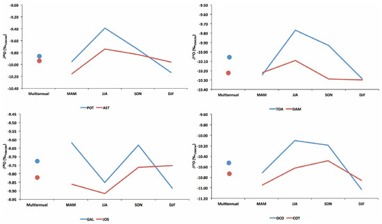
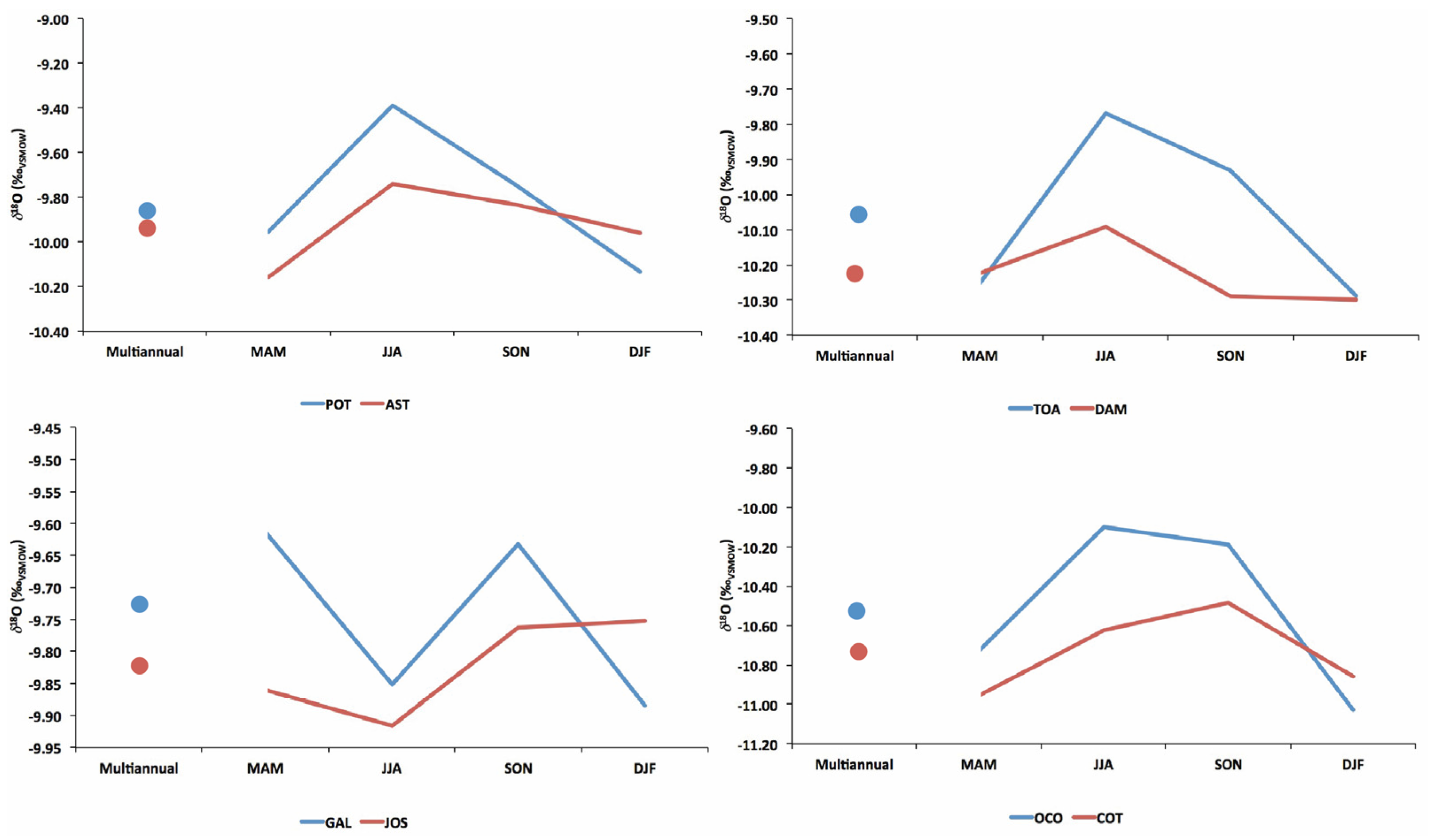
Figure 2.
Spring (March–April–May, MAM), summer (June–July–August), autumn (September–October–November, SON) and winter (December–January–February, DJF) average δ18O values of karst waters in four of the investigated karst systems. The blue and red dots in each panel represent the multiannual averages.
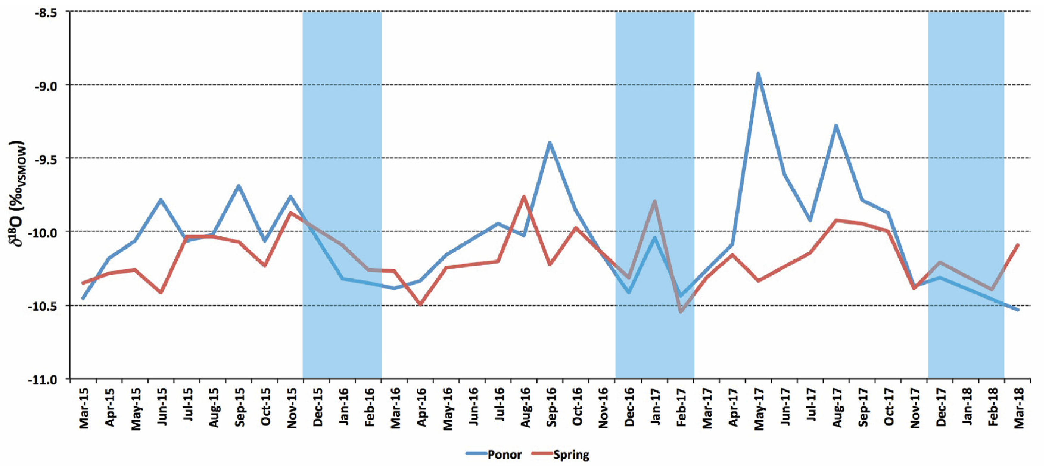
All karst waters have a weak intra-annual variability (Figure 3), with the lowest values occurring towards the end of the cold season (February or March) and the highest at the end of summer and beginning of autumn (August and September). In 2017, the maximum values occurred in the late spring, which was anomalously warm in SE Europe [15].

Figure 3.
Monthly average δ18O values of all investigated karst springs. The blue line shows the average values of all ponor samples and the red line shows the average value of all springs. Blue shading indicates winter months.
The Arieș River waters have similarly low variability of the δ18O (between −10.7‰ and −9.2‰) and δ2H (between −73‰ and −62‰) values, being lower in the winter months and higher in summer, apart from spring 2017, when the highest values are recorded. The d-excess parameter has a low range of variability, between 10.7‰ and 13.9‰ except for June 2017, when it reaches 8.3‰.
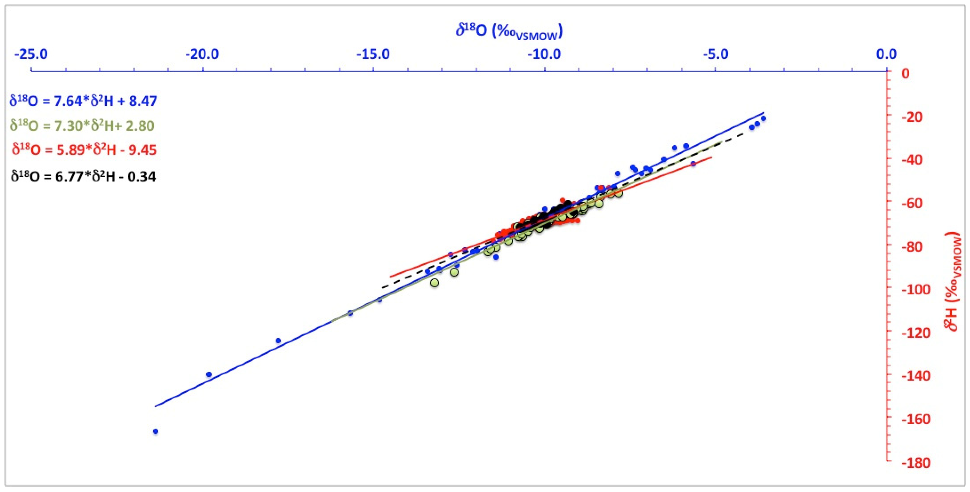
In Figure 4, the data are plotted in a δ18O-δ2H diagram against the Local Meteoric Water Line (LMWL, modified from [7]) from the central Apuseni Mountains. For the non-karst groundwater, we have plotted only the data from the Apuseni Mountains. All data lie on (or close to) the LMWL, defined by the equation δ18O = 7.64 × δ2H + 8.47. However, samples collected from non-karstic groundwater, rivers and karst waters plot along lines with successively lower slopes and intercepts (Figure 4).
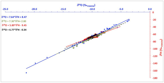
Figure 4.
Summary δ18O-δ2H diagram of the investigated waters. Blue dots and equation indicate precipitation, green dots and equation indicate non-karstic groundwater, black dots and equation indicate river water and red dots and equation indicate karst (ponor and spring) waters.
The δ18O values in groundwater in Romania (414 data points) have a narrow range of variability, between −13.2‰ and −7.8‰, and are mirrored by similarly narrowly distributed δ2H values (between −98‰ and −55‰). The lowest values are in the Southern Carpathian Mountains (the highest mountains in Romania), and the highest in the southern, western and eastern lowlands. Secondary spots of low values are in NW Romania, at the border with the Republic of Moldova and near the western border with Hungary.
4. Discussion
The distribution of δ18O in groundwater (Figure 5) clearly follows the local topography, with a few exceptions, discussed below. The Carpathian Mountains (maximum altitude 2544 m a.s.l.) act as an orographic barrier, blocking atmospheric moisture derived from the Atlantic Ocean, the Mediterranean Sea and the Black Sea [7,8]. Precipitation in Romania has a dual (Atlantic and Mediterranean) source on the western and southern flanks of the Carpathians [16,17], while Atlantic air masses and eastern (continental) sources dominate on their eastern flanks. Easterly sources dominate especially in winter, during periods of strong anticyclonic winds linked to the strengthened Siberian High over Asia picking up moisture from the Black Sea [8].
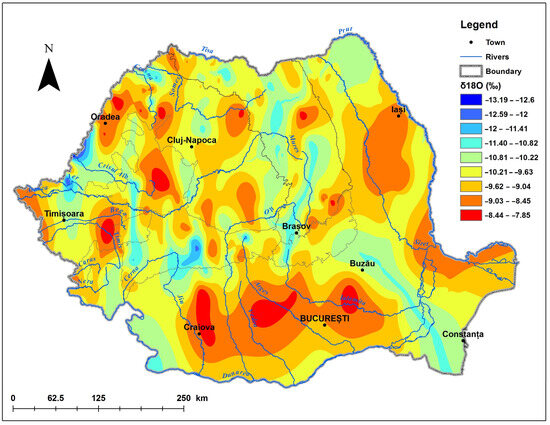
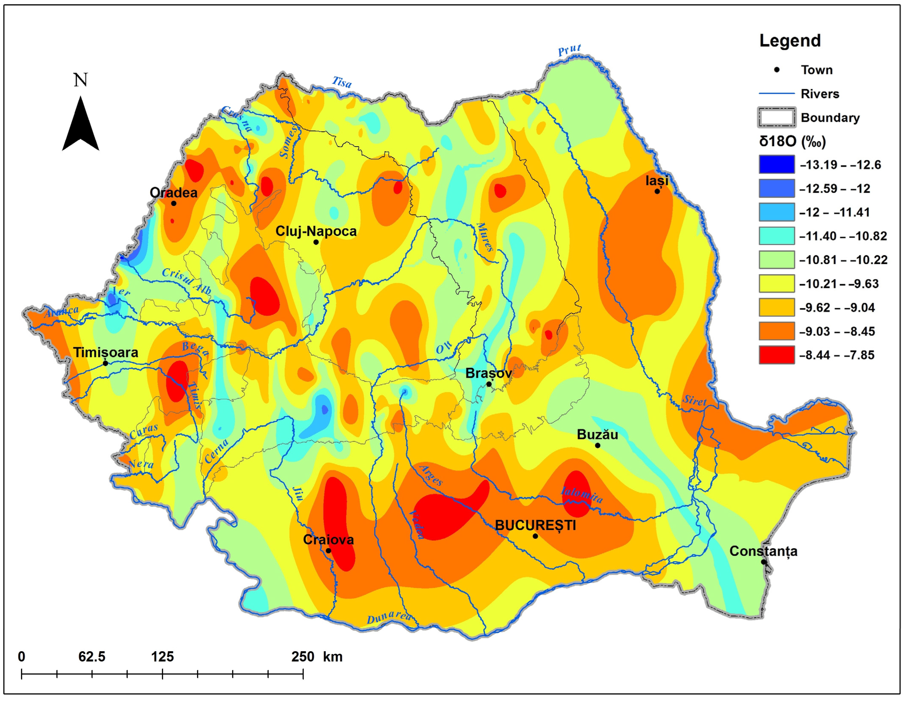
Figure 5.
Map of δ18O distribution in groundwater in Romania, with highest values in red and lowest in blue. Black lines show the outlines of the Carpathian Mountains.
These contributions result in the overall stable isotope composition of precipitation water with low values in the Carpathian Mountains and high values in western, southern and southeastern Romania. Under the influence of northerly cold air outbreaks, in northern Romania the δ18O and δ2H values in precipitation are lower, especially in winter [7]. This pattern is also discernible in the distribution of δ18O in groundwater presented in Figure 5, with the lowest values occurring in the high Southern Carpathian Mountains (with peaks above 2500 m a.s.l.), as well in the northern region (with almost similarly high peaks at 2300 m a.s.l). Groundwater in the lowlands has generally high δ18O and δ2H values, mainly as the combination of similarly high values in precipitation (e.g., [7]) and evaporation of rainwater before infiltration and/or from the soil. Especially in SE Romania, evapotranspiration exceeds precipitation [18], and this is clearly visible in the higher δ values. This progressive enrichment in heavy isotopes of the groundwaters is visible also in Figure 4, which shows groundwater samples aligning along an “evaporative line”, with a slope lower than that of precipitation [17,19]. The low values in NE Romania are likely linked to moisture derived from cold and dry continental Asia during winter [7,8]. Several departures from this overall distribution potentially reflect the influence of deep circulating waters rising to the surface (e.g., in western Romania, along the border with Hungary, where thermal waters are frequently encountered in springs and deep wells) and in SE Romania, where water from deep (~900 m below surface) aquifers reaches the surface and mixes with the surficial ones. However, a detailed study of these cases is beyond the scope of this paper, and it is being investigated elsewhere.
The stable isotopic composition of karstic waters is influenced by several factors, related to the nature of karst itself and the resulting complexities of recharge, storage and flow patterns, and these are analysed in detail below. Water in karst circulates through fissures, fractures (secondary porosity) and cave passages (tertiary porosity) developed in an otherwise low-permeability matrix (primary permeability). However, these pores of the limestone matrix are the main reservoirs of water in karst, with water being stored and released back to conduits in relation to flow characteristics [20,21,22].
As expected, the stable isotopic composition of karst waters has a much narrower range of δ18O and δ2H variability, compared to precipitation, as also observed by others [23]. However, notable differences exist between the river waters at the inflows and the outflows, the amplitude of δ18O and δ2H at the ponors being double than that of the springs. The average values of δ18O and δ2H in the springs are lower than in precipitation, a potential indication of preferential recharge from snow (see below). With one exception (the Gălășeni–Josani system, Figure 3), the maximum values of δ18O and δ2H were registered in the summer months, and the minimum ones in winter (again, with the exception of the Gălășeni–Josani system) reflecting the rapid transfer of surface waters through the karst system. In the Gălășeni–Josani system, the maxima occur in autumn and the minima in summer (JJA), suggesting either a delay of several months between the inflow and outflow, or an outsized contribution of matrix flow from water stored in the limestone matrix. The delay hypothesis is excluded, as fluorescein tracing showed a transfer time of only 13 h (Table 1), so we suggest that the waters of this system are mostly draining surface runoff and are less influenced by winter infiltration. The system is the shallowest (and second shortest) of all the investigated ones, thus with less matrix available for water storage and further release.
For all springs, the δ values of the outflowing water are generally lower than those of the inflows (Figure 2 and Figure 3), except in winter, when the trend reverses. In winter, the surface-flowing streams carry a much more depleted stable isotope signal, hence the lower δ values (Figure 2 and Figure 3) compared to the outflows. These differences suggest that the springs discharge a combination of river water entering through ponors and a contribution from seepage infiltration, likely biased towards winter recharge (e.g., [24,25]) as suggested by the lower δ values. Thus, we infer that the discharge of the springs consists mostly of water from snowmelt that slowly infiltrated through the epikarst and was mixed with point inflows. This is further supported by the observations of the rivers’ discharge before entering the caves and the corresponding discharges, the latter being generally higher, except in winter, when the two are more similar (likely because no water is released from the matrix, being stored at the surface as snow). Additionally, water can be stored in sediments along the cave passages (observed by cave divers in Aștileu and Dămișeni caves). During summer, these waters are slowly released back to the stream. Similar storage of karst waters in sediments has been inferred in other caves based on temperature measurements [20] and geochemical observations [25,26]. The one notable difference is the Vuiagă–Poliței system, in which the water in the Vuiagă Well discharges into local alluvium–colluvium aquifers, already strongly biased towards winter recharge.
An important result of this recharge (and subsequent discharge) pattern is the fact that the δ18O and δ2H values of karst springs do not reflect those of precipitation values at the springs’ altitude (e.g., [7]), but rather that of the recharge area (which could be higher) and/or preferential winter recharge, thus making construction of maps (e.g., Figure 1) problematic if these conditions are not properly accounted for.
Samples collected from karst waters and rivers show a similar evaporative trend, stronger in the case of karst waters, as opposed to those of the comparatively large Arieș River (Figure 4). This difference likely results from a combination of the very small discharge of the karst rivers reaching the ponors (in the order of tens of litres/m) and the strong evaporation process during the summer. For example, the Mniera Stream sinking into Peștera lui Potriva dries up completely in the summer months almost on a yearly basis. These heavily evaporated surface waters pass rapidly through the caves (Table 1) carrying the evaporative signal visible in the low d-excess values (between 8.3 and 3.3‰ in summer months) to the outflows. However, these low d-excess values at the springs occur only sporadically, a further indication of the strong mixing of point and diffuse sources of water feeding the springs.
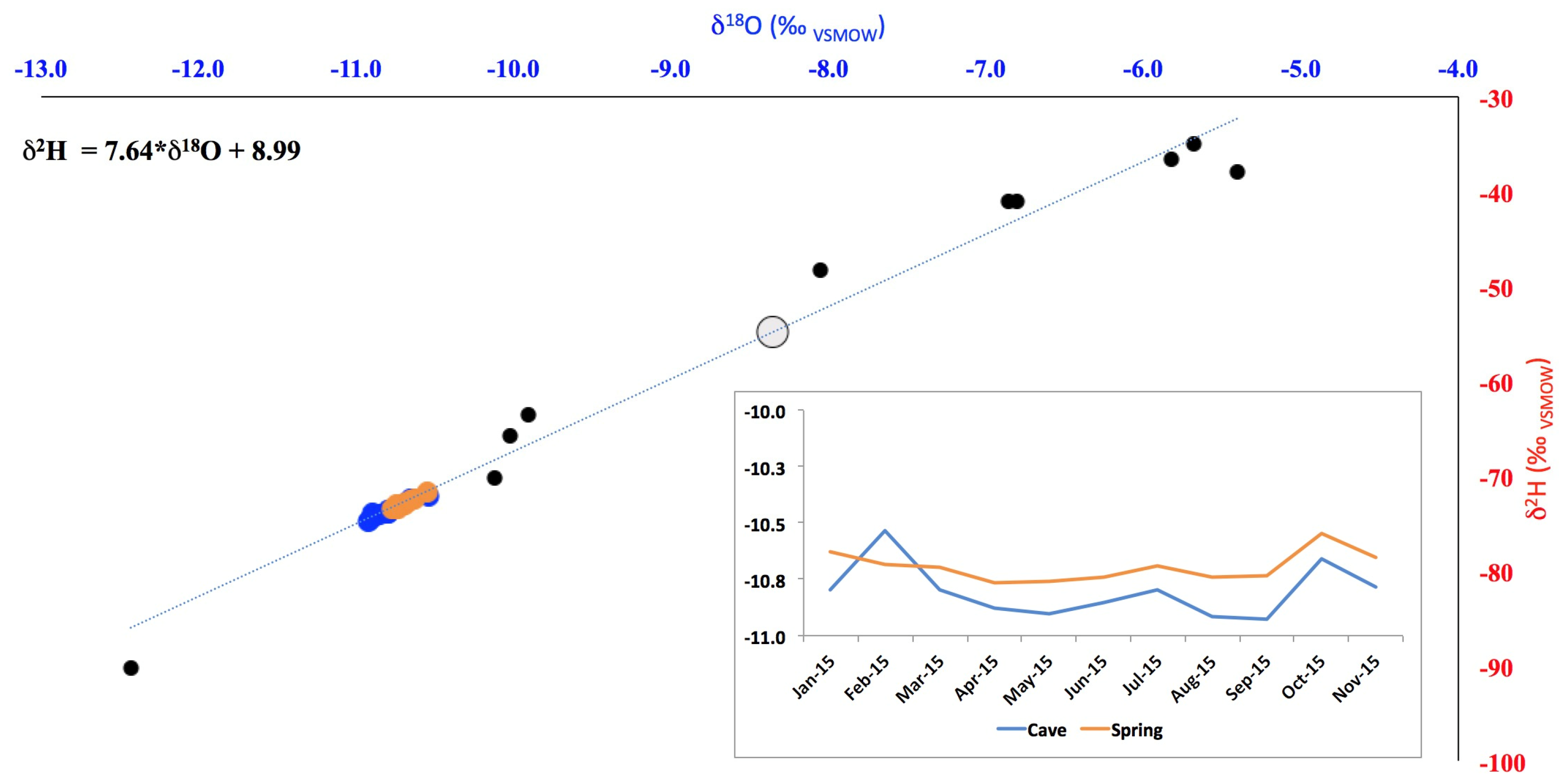
One notable exception for the above “rule” of lower δ values in the springs compared to the ponors can be seen at the Huda lui Păpară Cave (Figure 6). Here, sampling was carried out at two outflows, one through a cave river and the other through a spring. The variability of the two is similar, but the δ18O and δ2H values in the spring are always higher than those in the cave river. No direct connection between the two has been identified so far, but the similarities in δ18O and δ2H values suggest that the cave river in Huda lui Păpară is diverted through yet-unknown passages towards the spring and the slightly higher δ values could only be the result of slow flow through low porosity rock. In both spring and cave river, the average values are lower than in precipitation, again highlighting the outsized role of winter precipitation in recharging karst aquifers.
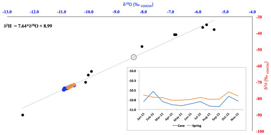
Figure 6.
Plot of δ18O vs. δ2H at Huda lui Păpară Cave. Black dots indicate precipitation, blue dots and line are the δ values at the cave and orange dots and line are the δ values at the spring. The grey dot indicates the average δ values of precipitation at the cave site.
Overall, the stable isotope data suggest that the investigated springs (except those in the Huda lui Păpară system) discharge a combination of point and diffuse inflow. The diffuse inflow component is likely the result of winter snowmelt infiltration through the soil and epikarst above the cave passages forming a reservoir of 18O and 2H-depleted water that slowly forms concentrated flows feeding the springs. On top of this baseflow, point inputs add additional water throughout the year. These findings are on a par with similar ones based on stable isotope analysis of drip water from caves in Romania [27,28] showing preferential recharge of the karstic aquifers during winter months and a combination of both slow (via primary porosity) and fast (through fissures and fractures) transfer of matrix water to cave passages [29]. Our results have further implications for understanding the potential of natural attenuation of pollution in karst. Previous studies [30] have identified a putative natural attenuation of pollution along the underground river passages we have investigated in this study, with an overall reduction in chemical and bacterial loads between the ponors and the springs. Our findings suggest that the attenuation of pollution might be the result of dilution of (polluted) water entering the karst through ponors with clean water infiltrated through soil cover and further filtered through several hundreds of meters of limestone.
5. Conclusions
We have analysed >600 samples of water collected across Romania from groundwater, to build a map of stable isotope distribution across the country and study the processes governing cave water movement along cave rivers. Our data illustrate first the main role of the general topography upon the distribution of δ18O in groundwater, with local/regional departures linked to either atmospheric circulation patterns (in NE Romania) or local hydrogeological conditions (in W Romania), where karst springs discharge water sourced from higher altitudes, thus skewing a simple altitude–stable isotope relationship. Second, we have identified that winter recharge through diffuse infiltration plays an important role in the overall hydrologic balance of karst springs. Our data show that the mass balance of small streams entering karst massifs is modified by addition of large volumes of water concentrated from diffuse infiltration processes through the rock above underground passages and these secondary sources form the base flow of springs draining the limestone massifs.
Overall, our data indicate that, even in the case where springs have clearly identified point sources (i.e., ponors), diffuse infiltration has an outside role in recharging the aquifers feeding these springs. These processes should be considered in both groundwater modelling studies and planning or managements of water resources, with further implications for speleogenesis and water pollution. Overall, stable isotope data from cave waters indicate complex recharge patterns of karst waters, and simple sink to resurgence approaches should be reconsidered.
Supplementary Materials
The following supporting information can be downloaded at: https://www.mdpi.com/article/10.3390/w16111489/s1, Table S1: Water groundwater supp data—the main characteristics of the stable isotope composition of the cave waters.
Author Contributions
Conceptualization, A.P.; methodology, A.P. and R.F.; validation, C.-A.B. and R.F.; formal analysis, R.F. and A.P.; investigation, C.-A.B., R.F., C.D., A.P., D.Ș.M. and V.D.; resources, R.F., D.Ș.M., V.D., C.D., T.B. and A.P.; data curation, R.F., V.D. and C.-A.B.; writing—original draft preparation, A.P.; writing—review and editing, R.F., A.P. and C.-A.B.; visualization, C.-A.B. and M.-L.T.; supervision, A.P.; project administration, R.F. and C.-A.B.; funding acquisition, A.P. All authors have read and agreed to the published version of the manuscript.
Funding
This research was funded by UEFISCDI Romania, grants number PN-III-P2-2.1-PED-2019-4102 and PN-III-P4-ID-PCE-2020-2723 and the IAEA, grants number 18452, 22895 and 23550. This work has been supported in part by Croatian Science Foundation under the project Dynamics and distribution of CO2 in karst vadose and epiphreatic zone (CARDIKARST) IPS -2022-02-2260.
Data Availability Statement
Precipitation and river stable isotope data will be made available in GNIP and GNIR.
Acknowledgments
We thank Viorica Nagavciuc for help in the laboratory, Anisia Domide for help in the field and the laboratory and the numerous owners of the springs and wells who allowed us to sample the water. We thank the Administration of the Apuseni Natural Park for sampling permits.
Conflicts of Interest
Author Dragoș Ștefan Măntoiu was employed by the company Wilderness Research and Consultancy. The remaining authors declare that the research was conducted in the absence of any commercial or financial relationships that could be construed as a potential conflict of interest.
References
- United Nations. Global Sustainable Development Report, 2015 Edition. Available online: https://www.un.org/en/development/desa/publications/global-sustainable-development-report-2015-edition.html (accessed on 21 April 2024).
- Ford, D.; Williams, P.D. Karst Hydrogeology and Geomorphology; John Wiley & Sons: Chichester, UK, 2007. [Google Scholar]
- Stevanović, Z. Karst waters in potable water supply: A global scale overview. Environ. Earth Sci. 2019, 78, 662. [Google Scholar] [CrossRef]
- Worthington, S. Characteristics of channel networks in unconfined carbonate aquifers. GSA Bull. 2014, 127, 759–769. [Google Scholar] [CrossRef]
- Hartmann, A.; Lange, J.; Weiler, M.; Arbel, Y.; Greenbaum, N. A new approach to model the spatial and temporal variability of recharge to karst aquifers. Hydrol. Earth Syst. Sci. 2012, 16, 2219–2231. [Google Scholar] [CrossRef]
- Williams, P.W. The role of the epikarst in karst and cave hydrogeology: A review. Int. J. Speleol. 2008, 37, 1–10. [Google Scholar] [CrossRef]
- Nagavciuc, V.; Perșoiu, A.; Bădăluță, C.-A.; Bogdevich, O.; Bănică, S.; Bîrsan, M.-V.; Boengiu, S.; Onaca, A.; Ionita, M. Defining a precipitation stable isotope framework in the wider Carpathian Region. Water 2022, 14, 2547. [Google Scholar] [CrossRef]
- Bădăluță, C.-A.; Perșoiu, A.; Ionita, M.; Nagavciuc, V.; Bistricean, P.-I. Stable H and O isotope-based investigation of moisture sources and their role in river and groundwater recharge in the NE Carpathian Mountains, East-Central Europe. Isot. Environ. Health Stud. 2019, 55, 161–178. [Google Scholar] [CrossRef]
- Koeniger, P.; Gaj, M.; Beyer, M.; Himmelsbach, T. Review on soil water isotope-based groundwater recharge estimations. Hydrol. Process. 2016, 30, 2817–2834. [Google Scholar] [CrossRef]
- Sprenger, M.; Stumpp, C.; Weiler, M.; Aeschbach, W.; Allen, S.T.; Benettin, P.; Maren, D.; Hartmann, A.; Hrachowitz, M.; Kirchner, J.W.; et al. The demographics of water: A review of water ages in the critical zone. Rev. Geophys. 2019, 57, 800–834. [Google Scholar] [CrossRef]
- Ponta, G.M.L.; Onac, B.P. Cave and Karst Systems of Romania; Springer: Cham, Switzerland, 2019. [Google Scholar]
- Rusu, T. Carstul din Munţii Pădurea Craiului; Dacia: Cluj-Napoca, Romania, 1988. [Google Scholar]
- Orăşeanu, I.; Iurkiewicz, A. Karst Hydrogeology of Romania; Belvedere: Oradea, Romania, 2010. [Google Scholar]
- Feher, R.; Voiculescu, M.; Chiroiu, P.; Perșoiu, A. The stable isotope composition of hoarfrost. Isot. Environ. Health Stud. 2021, 57, 386–399. [Google Scholar] [CrossRef] [PubMed]
- Copernicus Climate Change Service (C3S). Available online: https://climate.copernicus.eu/climate-2017-european-temperature (accessed on 23 April 2024).
- Bojar, A.V.; Ottner, F.; Bojar, H.P.; Grigorescu, D.; Perşoiu, A. Stable isotope and mineralogical investigations on clays from the Late Cretaceous sequences, Haţeg Basin, Romania. Appl. Clay Sci. 2009, 45, 155–163. [Google Scholar] [CrossRef]
- Bojar, A.V.; Halas, S.; Bojar, H.P.; Chmiel, S. Stable isotope hydrology of precipitation and groundwater of a region with high continentality, South Carpathians, Romania. Carpathian J. Earth Environ. Sci. 2017, 12, 513–524. [Google Scholar]
- Busuioc, A.; Dobrinescu, A.; Bîrsan, M.V.; Dumitrescu, A.; Orzan, A. Spatial and temporal variability of climate extremes in Romania and associated large-scale mechanisms. Int. J. Clim. 2014, 35, 1278–1300. [Google Scholar] [CrossRef]
- Gibson, J.J.; Birks, S.J.; Yi, Y. Stable isotope mass balance of lakes: A contemporary perspective. Quat. Sci. Rev. 2016, 131, 316–328. [Google Scholar] [CrossRef]
- Skoglund, R.Ø.; Pennos, C.; Perşoiu, A.; Sotiriadis, Y. Karstic Aquifers—Simple or Hybrid Systems? Thermal Stories from Maaras Cave, Greece. Water 2023, 15, 488. [Google Scholar] [CrossRef]
- Liedl, R.; Sauter, M.; Hückinghaus, D.; Clemens, T.; Teutsch, G. Simulation of the development of karst aquifers using a cou-pled continuum pipe flow model. Water Resour. Res. 2003, 39, 1057. [Google Scholar] [CrossRef]
- Dreybrodt, W.; Gabrovšek, F.; Romanov, D. Processes of a Speleogenessis: A Modeling Approach; Založba ZRC: Ljubljana, Slovenia, 2005; Volume 4. [Google Scholar]
- Chimenti, M.; Natali, S.; Giannecchini, R.; Zanchetta, G.; Baneschi, I.; Doveri, M.; Isola, I.; Piccini, L. Hydrogeochemistry and Isotopic Composition of Waters in the Renella Cave (Central Italy): New Insights into Groundwater Dynamics. Water 2023, 15, 1764. [Google Scholar] [CrossRef]
- Jasechko, S.; Wassenaar, L.I.; Mayer, B. Isotopic evidence for widespread cold- season-biased groundwater recharge and young streamflow across Central Canada. Hydrol. Process. 2017, 31, 2196–2209. [Google Scholar] [CrossRef]
- Jasechko, S.; Birks, J.S.; Gleeson, T.; Wada, Y.; Fawcett, P.J.; Sharp, Z.D.; McDonnell, J.J.; Welker, J.M. The pronounced seasonality of global groundwater recharge. Water Resour. Res. 2014, 50, 8845–8867. [Google Scholar] [CrossRef]
- Kiyanii, V.; Esmaili, A.; Alijani, F.; Samani, S.; Vasić, L. Investigation of drainage structures in the karst aquifer system through turbidity anomaly, hydrological, geochemical, and stable isotope analysis (Kiyan springs, western Iran). Environ. Earth Sci. 2022, 81, 517. [Google Scholar] [CrossRef]
- Ersek, V.; Onac, B.P.; Perșoiu, A. Kinetic processes and stable isotopes in cave dripwaters as indicators of winter severity. Hydrol. Process. 2018, 32, 2856–2862. [Google Scholar] [CrossRef]
- Drăgușin, V.; Balan, S.; Blamart, D.; Forray, F.L.; Marin, C.; Mirea, I.; Nagavciuc, V.; Perșoiu, A.; Tîrlă, L.; Tudorache, A.; et al. Transfer of environmental signals from surface to the underground at Ascunsă Cave, Romania. Hydrol. Earth Syst. Sc. 2017, 21, 5357–5373. [Google Scholar] [CrossRef]
- Moldovan, O.; Meleg, I.; Perşoiu, A. Habitat fragmentation and its effects on groundwater populations. Ecohydrology 2012, 5, 445–452. [Google Scholar] [CrossRef]
- Brad, T.; Fekete, A.; Sandor, M.S.; Purcarea, C. Natural attenuation potential of selected hydrokarst systems in the Carpathian Mountains (Romania). Water Sci. Technol. Water Supply 2015, 15, 196–206. [Google Scholar] [CrossRef]
Disclaimer/Publisher’s Note: The statements, opinions and data contained in all publications are solely those of the individual author(s) and contributor(s) and not of MDPI and/or the editor(s). MDPI and/or the editor(s) disclaim responsibility for any injury to people or property resulting from any ideas, methods, instructions or products referred to in the content. |
© 2024 by the authors. Licensee MDPI, Basel, Switzerland. This article is an open access article distributed under the terms and conditions of the Creative Commons Attribution (CC BY) license (https://creativecommons.org/licenses/by/4.0/).