Article

Conceptual Model Based on Groundwater Dynamics in the Northern Croatian Dinaric Region at the Transition from the Deep Karst and Fluviokarst

1
Department of Hydrogeology and Engineering Geology, Croatian Geological Survey, Milana Sachsa 2, 10000 Zagreb, Croatia
2
Department of Geology and Geological Engineering, Faculty of Mining, Geology and Petroleum Engineering, University of Zagreb, Pierottijeva 6, 10000 Zagreb, Croatia
*
Author to whom correspondence should be addressed.
Water 2024, 16(11), 1630; https://doi.org/10.3390/w16111630
Submission received: 16 May 2024 / Revised: 31 May 2024 / Accepted: 1 June 2024 / Published: 6 June 2024
(This article belongs to the Special Issue Research on Hydrogeology and Hydrochemistry: Challenges and Prospects)

Abstract

:
The Dinaric karst in the north differs from the rest of the karst in Croatia in terms of karstification depth. The infiltrating precipitation drains in cascades from deeply karstified mountainous areas to the shallow or fluviokarst, forming the tributaries of the Kupa River. Time series analyses were conducted on a 5-year dataset to elucidate the hydrogeological conceptual model of the area and clarify disparate findings from tracer tests under varying hydrological conditions. The flow duration curve, autocorrelation functions, and recession curves were used to evaluate the spring discharge variability, the karstification degree, and the karst aquifer’s size. The crosscorrelation function and temperature dynamics were employed to assess the spring’s response to recharge and the hydrogeological system behavior. Comparative analysis with previous studies was conducted to contextualize the obtained results. The research outcomes delineated several key findings: (i) the deep karst zone is less developed than the shallow karst zone; (ii) groundwater exchange is significantly faster in shallow karst; (iii) groundwater divides in the Kapela Mountain are zonal; (iv) the homogenization of groundwater occurs during periods of high water levels; (v) fast water exchange transpires without concurrent groundwater temperature homogenization; and (vi) a definition of the boundary between deep and fluviokarst in Croatia.

1. Introduction

Karst aquifers are widely acknowledged as the most anisotropic and heterogeneous groundwater systems, with limits in research possibilities [1]. The high permeability of karst rocks facilitates rapid infiltration of precipitation and swift drainage of water through well-developed conduit systems, referred to as fast-flow. Conversely, slower drainage is attributed to the laminar flow within a matrix or fissures, fractures, and small conduits, known as base-flow [2,3,4]. Hydraulic conditions within the aquifer govern the pathway of the water flow, which tends to gravitate towards areas of lower pressure, directly depending on aquifer saturation. The interconnected karst network culminates in a discharge at an exsurgence, or a karst spring. The hydrograph of karst springs typically exhibits distinct, sudden peaks caused by discharge fluctuations, with short-term delayed reactions to rainfall and a gradual decline during dry periods [4,5]. Hydrodynamical characterization of an extensive karst system with similar behaviors to karst springs is challenging. Conventional hydrogeological surveys, such as tracing and borehole tests, supplemented by geophysical and speleological observations, provide only limited insights into the hydraulic properties and spatial configuration of underground networks, depending on the survey locations and hydrological conditions at the time of investigation [6,7].
Consequently, a good understanding of the hydrodynamics and functioning of karst aquifers is achieved through comprehensive analysis of karst spring hydrographs, which encapsulate the system’s global response, including recharge, storage and throughflow [8]. Karst aquifers represent formations with conduits, fractures, and fissures embedded within relatively low-permeability rock with numerous outflows. In highly karstified environments, catchment boundaries often exhibit variable zonation, causing difficulty in quantifying and spatially delineating input into the system. Hence, time series statistical analyses are a valuable tool for elucidating the characteristics of specific systems and their interconnections.
Time series analyses of a springs discharge and water temperature, accompanied by classical hydrogeological prospection techniques from previous studies, have proven instrumental in comprehending the dynamics of complex karst systems, particularly in extensive karst mountains where numerous springs react differently depending on the precipitation distribution and aquifer saturation levels. Hydrograph recession curve analyses (RCA) have been used for over a century, undergoing constant methodological refinements [9,10,11,12,13,14,15,16,17,18,19,20,21], and serving to infer aquifer hydraulic or geometrical properties [3,21,22] and/or ascertain the karstification degree based on the flow type [6,23,24].
The flow duration curve (FDC) provides a graphical representation of the percentage of time within a given period when the discharge rate equals or exceeds a specific threshold. This method is employed to evaluate the range and fluctuation of spring discharge [25,26,27].
Autocorrelation functions (AFC) quantify the system’s memory effect [7,28], while the crosscorrelation function (CCF) offers a comprehensive perspective of the relationship between two series, such as precipitation and spring discharge [29,30,31], allowing definition of the aquifer’s response to recharge impulses and the interrelationship between discharge patterns [25,32,33].
However, approx. 50% of Croatia’s territory lies within karstic areas, primarily in the Dinaric karst regions. The study area exhibits pronounced karstification attributed to tectonics, and is recognized as the most karstified part within the Dinaric karst region, according to the high sinkhole density [34]. However, due to the sparse population and low anthropogenic activities in the mountain catchment area, low to very low values of the groundwater quality index (WQIgw) are assigned to the most significant part of the study area [35], meaning good water quality.
The terrain has also been disturbed by numerous hydrotechnical constructions, including accumulations, dams, and tunnels. These man-made interventions, dating back almost a century, are considered as baseline conditions for the area. The construction of a hydropower plant caused significant changes in the hydrogeological and hydrological settings, while the hydropower potential will be additionally exploited as the construction of retention walls in the Drežnica polje started in 2022. Furthermore, the ongoing revitalization of a ski resort, hotel settlement, and sports-recreation center of the Croatian Olympic Centre Bjelolasica could cause additional pressure on the strategically crucial hydrogeological system and the water quality.
The hydrogeology of the study area has been described based on its tectonics and lithological composition [36]. Numerous groundwater tracing tests were carried out over 70 years ago to define the catchment boundaries, yet were greatly limited by available instruments and methods, reflecting only certain hydrological conditions.
This paper examines a 5-years dataset from six springs and five meteorological stations, utilizing analysis including RCA, FDC, ACF, and CCF, alongside temperature dynamics. The objectives are to (1) define the hydrological characteristics of the transition zone from deep to shallow karst in north Dinaric Croatia, (2) develop a conceptual hydrogeological model to address the discrepancies in tracing results within the Kapela Mountain (referred to as Kapela), and (3) characterize new hydrogeological relations concerning human interventions in the area as zero-state.
The groundwater dynamics of the deeply karstified area in Kapela was performed through time series analyses of four observed springs: Draškovac, Vitunj, Zagorska Mrežnica, and Bistrac Sabljaki. These springs feed short watercourses through the Ogulin polje and subsequently sink into a well-developed karst network up to 100 m deep, contributing groundwater downstream to numerous springs, from which the Gojak and Tounjčica springs are analyzed in this paper, and form the Kupa River tributaries. This paper is the first of its kind in this study area, employing statistical methods to characterize the regional hydrogeological relationships. In this research area, many open questions remain, and the watersheds are not clearly defined. For example, the Jasenak polje, according to official sanitary protection zones, belongs within the catchment area of the Mrežnica River, while according to official river watershed classifications, it falls within the catchment area of the Dobra River. A combined hydrological and hydrogeochemical approach was previously used in research on the neighboring catchments like the Gacka River springs [33,37,38], the mountainous section of the Kupa River in the north [39,40], and the Lička Jesenica catchment [41]. In this research area, Buljan et al. [42] studied the immediate watershed of the Zagorska Mrežnica spring, and Bonacci and Andrić [43] examined the effects of hydro-technical building and climate change on the Dobra River catchment.
The scientific novelty of this research lies in the comprehensive time series analysis, alongside temperature dynamics, to understand the hydrological characteristics and groundwater dynamics, and give new insights into the hydrogeological impacts of long-standing human interventions. This research addresses discrepancies in historical groundwater tracing results giving explanations for illogical tracing results and provides evidence that tracer tests are not unambiguous and depend on the conditions, primarily on the aquifers saturation in which they are performed, contributing to effective and sustainable management. Additionally, the applied methods and review of previous studies dynamically characterized the transition zone from a deep to shallow karst, which has been only described descriptively so far, and positions it more precisely geographically.

2. Materials and Methods

2.1. Setting

The study area is located in the northern part of the Dinaric karst region of Croatia (Figure 1) and is a central part of the karstic transboundary Kupa River catchment area. Its western boundary delineates the catchment divide between the Adriatic and Black Sea. The Ogulinska Dobra and Zagorska Mrežnica are sinking rivers that form a karst landscape, the Dobra Valley and the Ogulin polje. The Ogulinska Dobra River originates in clastic formations with numerous small springs in the north, transversing less permeable dolomite to dolomitic limestone over a 51.2 km long watercourse. The research area starts where Ogulinska Dobra waterflow receives significant water input from right tributaries, namely the Kamačnik, the Ribnjak stream, and the Vitunjčica River, which drains the highly tectonized limestone. About 4 km upstream of Ogulin city, the Bukovnik Reservoir collects water from the Ogulinska Dobra. Water from the reservoir is conveyed via a technical tunnel to the Gojak hydropower plant (HPP Gojak). Naturally, or when the reservoir is full, the Ogulinska Dobra River sinks into a 40 m deep ponor, located in Ogulin city. The ponor marks the start of an extensive cave system, Đula-Medvedica, a natural karst drainage system spanning 16 396 m through limestone, with a vertical range of 83 m. The underground flow reemerges at the Gojak spring, where the Dobra River starts its watercourse. The shortest aerial distance between the Đula ponor and the Gojak spring is approx. 4.6 km [43]. The HPP Gojak was built about 100 m downstream from the Gojak spring.
The major spring of the Ogulin polje, the Zagorska Mrežnica, along with the Bistrac Sabljaki and many smaller springs on the south edge, fill the artificial hydro-technical Sabljaki lake. This reservoir was built in 1954, alongside the natural course of the Zagorska Mrežnica River. Before the intervention and during high water levels, the river used to submerge into numerous sinkholes spanning the SW part of the polje. The groundwater connections within the Tounjčica catchments were identified through the first tracing experiment conducted in Croatia [44].
Water is transferred via a tunnel from the Sabljaki Reservoir to the Bukovnik Reservoir and then to the HPP Gojak on the Dobra River. This inter-catchment process redirects water from the Mrežnica River to the Dobra River catchment area, thereby decreasing water levels in the Tounjčica River, with a substantial drop in the average annual discharge, which is now 9.8 m3/s [43]. These authors noted that the construction of the HPP Gojak did not exert any discernible impact on the discharge of the Zagorska Mrežnica and Vitunj springs. However, the reduction of water loss at the gauging stations upstream in Ogulinska Dobra was explained with an increase in the groundwater level in the broader area of the Ogulin polje caused by the construction of the reservoirs.
In addition to its importance for hydroenergy, the Zagorska Mrežnica serves as the main source of drinking water for Ogulin city with a maximum capacity of 200 L/s (with an average of 74 L/s), which is far below the spring’s potential capacity. In the wider area of the polje, the water supply is equipped with a few smaller captured springs up to a flow rate of <16 L/s. Across the Kapela, two water intakes meet the needs of the sparse population, in the Jasenak and Krakar polje, each with a flow rate of 5 L/s. According to the water law license, the cumulative maximum flow rate for the Ogulin water supply system is 18.302 m3/day. The study area exhibits a continental and mountainous climate regime, predominantly influenced by the relief’s horizontal and vertical division. The Kapela obstructs the humid air masses from the Mediterranean and Atlantic, resulting in the highest amount of precipitation in Croatia. The mean annual temperature of the mountainous belt remains below 6 °C. Annual precipitation levels are considerable and vary between 1750 and 2500 mm, contributing to substantial spring discharges at the mountain’s foothills. Furthermore, the dynamics of aquifers is notably affected by the snow cover, which typically persists for approx. 60 days annually. The seasons are much more pronounced in the wider area of the Ogulin polje, with prolonged periods without precipitation. Summers are dry and warm, while the winters are wet and cold. The average annual temperature in the lower parts ranges from 10 to 11 °C with an average annual rainfall of 1250–1500 mm. The duration of snow cover in these areas averages around 40 days per year [45,46].

2.2. Hydrogeological Characteristics

The area under investigation represents a part of the Adriatic carbonate microplate formed by the sedimentation of carbonate rocks between the Triassic and Lower Cretaceous. This geological formation has been analyzed and interpreted in numerous publications [47,48,49,50]. Nevertheless, researchers remain focused on the complex geological, structural, and tectonic frameworks caused by ongoing compressional tectonics that began in the Paleogene era and resulted in a zone of steep faults, generally striking in a NW–SE direction [51]. A basic geological map at a scale of 1:100,000 was created for the entire research area and is divided into three sheets: Ogulin [52], Crikvenica [53] and Črnomelj [54]. The rocks within the research area were classified into three primary hydrogeological groups regarding their lithology and structural–geological relations:
High-permeability carbonates—represented predominantly by limestone and thinner beds or interbeds of dolomite or dolomitic limestone, formed by deposition between the Jurassic and the Cretaceous.
Low-permeability carbonates—lower degree of karstification, mainly composed of dolomite, dolomitized limestone, or dolomite/limestone exchange, with dissolution cavities infilled with secondary materials like silt, sand, and fragments, deposited from the Upper Triassic to Lower Cretaceous.
Quaternary deposits—encompass heterogeneous deposits, mostly mixtures of rock fragments and fine-grained material. The soil covers the carbonate base across the entire area, but their hydrogeological significance is only notable within morphological depressions such as karst poljes.
The lithology, thickness, and tectonics define the rock permeability, while their hydrogeological function depends on the hypsometric and structural positions. Groundwater flow is influenced by numerous, often regional, intersecting fractures, normal and inverse folds, reverse faults, and thrusts.
The part of the Croatian Dinaric karst investigated in this study differs from the rest of the Croatian karst due to the most recent erosional base. Unlike the majority of karst formations in the Dinarides, the erosional base in this area is relatively shallow and has not accumulated like most of the karst in the Dinarides. The karst of the Adriatic catchment area, located to the southwest of the study area, is distinguished by significant karstification depths exceeding 1500 m, particularly in southern regions with pronounced vertical karstification [55]. The study area can be divided into three distinct zones: (1) the Kapela, characterized by karstification depths of several hundred meters and cascading discharge, (2) the Ogulin polje serving as a hydrogeological barrier, and (3) a shallow karst or fluviokarst zone with karstification depths reaching a maximum of approx. 200 m. As a result of significant karstification across the study area, groundwater primarily flows orthogonal to the NW-SE oriented Dinaric formations.
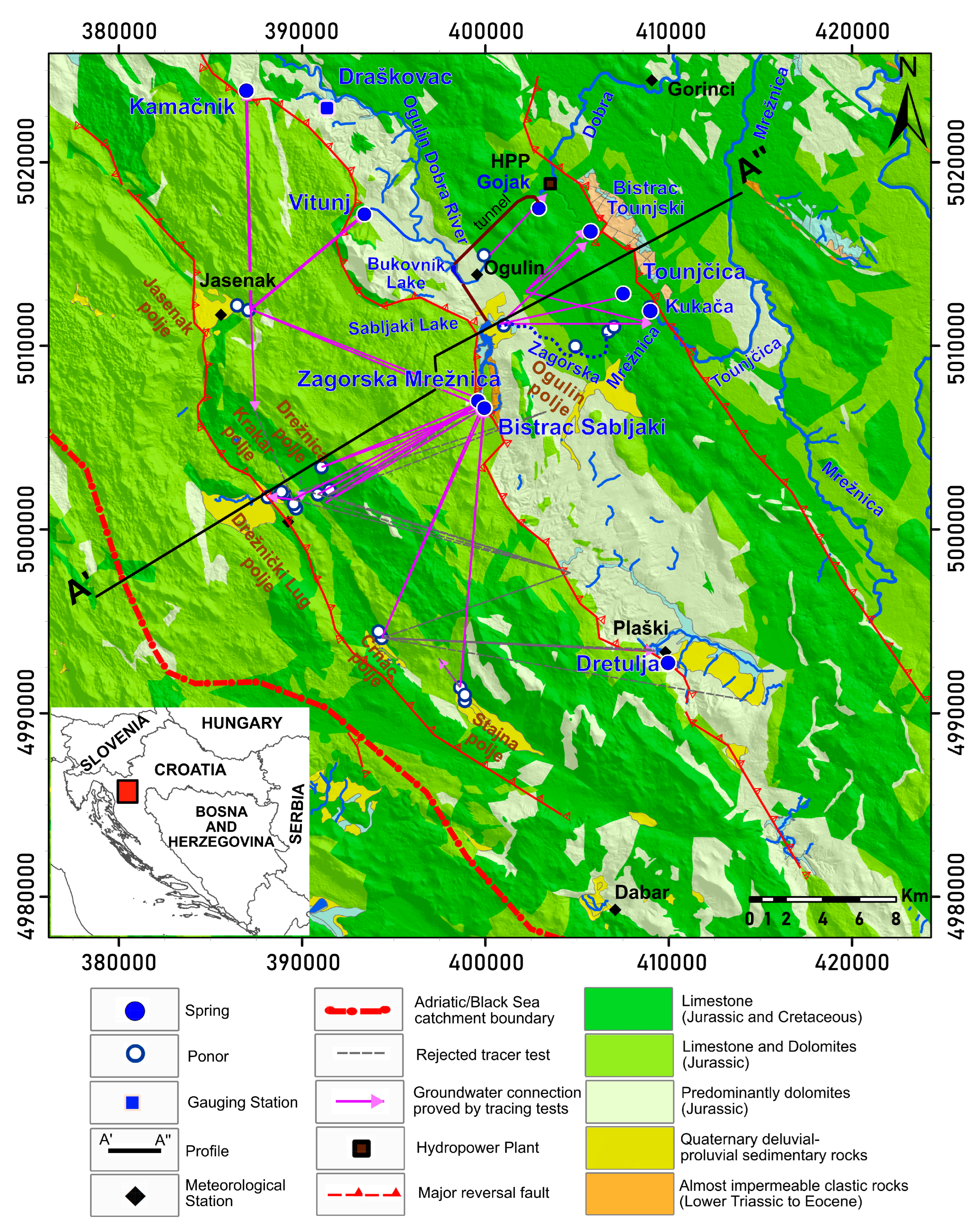
Kapela is the first recharge area formed by substantially fractured Jurassic and Cretaceous rocks of high secondary porosity, provided by limestone with thinner beds of dolomites or dolomitic limestone. Abundant karstic forms in this area result in rare and ephemeral surface watercourses during dry periods. Highly karstified rocks facilitate substantial groundwater accumulation. The caves are primarily horizontal and shallow, not exceeding 100 m [56]. Typical for karst, the springs are periodic and have large discharge oscillations. During wet seasons, the flooded karst poljes feed the springs situated at the mountain’s base. Groundwater connections under varying hydrological conditions have been elucidated through numerous tracing experiments (summarized in Section 3.2. Hidrogeological Conceptual Model of Karst System). Tracing results have revealed a direct connection between the Crnac, Drežnica and Stajnica poljes only with springs located at the southern side of the Sabljaki lake, including the Zagorska Mrežnica and Bistrac Sabljaki springs (Figure 2). In the northernmost Jasenak polje, tracing experiments were carried out twice under different hydrological conditions. In 1972, during high water levels, tracing established a groundwater connection between the Kamačnik and Vitunj springs in the Ogulinska Dobra River basin, but also with the spring in the Krakar polje, which undoubtedly gravitates towards the Drežnica polje and the Zagorska Mrežnica and Bistrac Sabljaki springs. Conversely, during low water conditions, only connectivity with the springs of the Zagorska Mrežnica and the Bistrac was observed, with no tracers appearing in the Krakar polje (1986).
At the foot of the mountain, the Jurassic dolomites and Triassic clastic rocks form a hydrogeological barrier and through Quaternary deluvial–proluvial sedimentary rocks direct the groundwater and cause abundant springing along the Ogulin polje and the Dobra valley [36,42,57]. The low permeability of carbonate rocks and nearly impermeable clastic formations facilitate surface runoff and allow retention within hydropower reservoirs. In the west part of the Ogulin polje, surface water sinks underground in the area of highly permeable limestone or the shallow karst zone. This area exhibits a high density of sinkholes and extensive underground karst formations, indicating the most karstified area of the Dinaric karst [34]. The caves extend horizontally for several kilometers, with height differences of less than 80 m. After 5 to 15 km, the groundwater resurfaces at the karst plateau approx. 100 m lower in elevation, forming direct tributaries of the Kupa River, the Dobra, and the Mrežnica River. This part of the Dinaric karst in Croatia, situated north of the Kapela, is significantly different from the rest of the Dinaric karst. While much of the Croatian Dinaric karst is tectonically “accumulated”, reaching depths of kilometers, this northern region exhibits limited karstification confined to the recent erosional base of major rivers in the area (Kupa, Mrežnica, Korana, and Dobra) at the groundwater level. This area is known as a shallow karst or typical fluviokarst.

2.3. Methods and Data

Hourly data are indispensable for analyzing the dynamic characteristics of a highly karstified karst system, given its rapid response [40,42]. Precipitation, discharge, and water temperature data were systematically collected at hourly intervals over a five-year period from January 2018 to December 2022. The Croatian Electric Power Company (HEP) provided discharge and water temperature data from six gauging stations, four of which reflect the aquifer characteristics in the mountain catchment area across the Kapela: Vitunj, Draškovac, Zagorska Mrežnica, and Bistrac Sabljaki springs. The remaining two stations, Gojak and Tounjčica, located downstream of the Ogulin polje, represent the zone of shallow karst.
The Draškovac station, located in the stream formed by two springs, facilitates a clear interpretation of the aquifer’s response, due to their close proximity. Flow data expressed in the decimal number were available for all stations from May 2020 to December 2022. Hence, only this subset was used for detailed hourly analyses. HOBO Water Level Data Loggers (Oneset Computer Corporation, Bourne, MA, USA) were deployed in February 2020 in the Tounjčica and Zagorska Mrežnica springs to minimize atmospheric influences and accurately measure the water temperature. They also served as water level controls.
Groundwater sampling was performed thrice for all monitored springs to determine the main components of the chemical composition of the groundwater, the origin and the comparison between springs. The nitrate, sulphate, and chloride concentrations were utilized to assess the quality of the water. Concentrations of the major anions and cations in the water samples were analyzed using ion chromatography (Thermo Scientific Dionex ICS-6000 HPIC System, Thermo Fisher Scientific Inc., Waltham, MA, USA) in the Croatian Geological Survey.
Hourly precipitation data were obtained from three meteorological stations in the study area by the Croatian Meteorological and Hydrological Service (DHMZ): Jasenak station in Kapela (629 m a.s.l.), Ogulin station (328 m a.s.l.) and Gorinci station (203 m a.s.l.), located 0.5 km from the Gojak spring. Additionally, daily precipitation data from meteorological stations in the Dabar polje (573 m a.s.l.) and the Plaški station (395 m a.s.l.) were utilized to assess the influence of the wider research area. Although Plaški is not within the direct catchment area, it is the closest station on the southern side of the study area, and alongside the Ogulin and Gorinci stations represent the immediate catchment area of the springs (Figure 1).
Time series analyses and spring runoff hydrographs reflect the aquifer’s comprehensive reaction to the system’s input and output [21], while aquifers behave like a black box. A karst springs’ discharge variability is primarily associated with the geometry and physical properties of the system and recharge intensity. To characterize a spring’s catchment area, three methods based on discharge data were employed: (1) flow duration curve (FDC) analysis, (2) recession curves analysis (RCA), and (3) autocorrelation function (ACF) analysis. The CCF and water temperature dynamics were used to elucidate the karst system’s response to precipitation and the interconnectedness between springs.
FDC analysis of springs assesses the extent and variability of spring discharge, representing the percentage of time during which spring’s flow rates exceed a predetermined threshold [4,23]. This analysis entails organizing and plotting discharge values in descending order, irrespective of their chronological sequence. The resulting graph displays discharge along the vertical axis and the percentage of monitored time during which the specified flow-rate threshold is exceeded along the horizontal axis. The steepness of the duration curve indicates deducing key karst systems characteristics; steeper slopes suggest a well-developed system characterized by conduit-dominant flow; conversely, gentler slopes signify systems with slower circulation, greater storage capacity, and lower degrees of karstification [26,58].
RCA is a valuable tool in karst hydrogeological research, focused at understanding the structural characteristics and storage properties of the aquifer based on their response to recharge events. This method involves analyzing the declining limbs of runoff hydrographs, independently of other system parameters, and quantifying the recession coefficient (α) using a simple exponential equation:
Q t = Q 0 e α t t 0  
where Qt is the discharge at time t, Q0 is the initial discharge at time t0, and α is the recession coefficient.
The α correlates with the degree of aquifer karstification, including permeability and porosity, but it also depends on the aquifer saturation [3,4,6,11,19,23,59,60,61,62]. Due to multiple influences, the α tends to be lower in catchments characterized by lower karstification, thicker deposits, or dense forest cover.
The “matching-strip” tool program was chosen for its ability to utilize all recessionary events, which in the study area’s climatic conditions typically lasts no more than 20 days. Developed by Posavec et al. [16,18], the MRCTools v3.1 tool operates on an Excel Visual Basic for Applications (VBAs) algorithm and is used to assemble the master recession curve (MRC) from the partial recessional limbs observed in each spring’s hydrograph. The MRC is further subdivided into typically two or three discharge micro-regimes, each describing distinct reservoirs with varying hydrogeological characteristics. This subdivision is facilitated by the FDC analysis of daily discharges, allowing pinpointing of the crucial discharge points where a sudden and significant shift in the curve’s slope occurs [17]. Engineering expertise and a thorough understanding of the terrain are essential for an objective analysis.
The ACF analysis is a statistical tool used to analyze and quantify the degree of similarity between values within a single time series, taking into account their temporal separation [63]. The relation of the autocovariance covxx can be described as the variance of the signal x for a single event measurement in time t, where x(t) with n data points over lag time, k [31].
r k = c o v x x k c o v x x 0
In which:
c o v x x ( k ) = 1 n     t = 1 n k x t x ¯ x t + k x ¯   k = 0 , 1 , 2 ( n 1 )
c o v x x 0 = 1 n     t = 1 n   x t x ¯ 2  
In hydrogeology, the mathematical analysis of discharge data enables the evaluation of a karst system’s response to recharge and quantifies the system’s memory effect based on decorrelation lag time. It is assumed that the system loses the input impulse once the ACF value attains a predetermined threshold, usually set at 0.2 [7,28,31]. A significant memory effect is frequently associated with a high storage capacity of the system [4,64].
The CCF analysis represents the correlation between two time series data, defining the covariance covxy and the lag time between them [63]:
c o v x y = 1 n     t = 1 n k x t x ¯ y t + k y ¯   k = 0 , 1 , 2 ( n 1 )
c o v x y = 1 n   t = 1 k n x t x ¯ y t + k y ¯   k = 0 , 1 , 2 ( n 1 )
where x ¯ and ȳ are the average of the input and output parameters. CCF is defined as:
r x y   ( k ) = c o v x y ( k ) c o v x x ( 0 ) c o v x y ( 0 )
This method was used to examine linear relations between input (rainfall) and output (discharge) signals of karst systems [25,31,33], aiming to define the travel time of meteoric water through the vadose zone and discern the similarity between two springs. The ACF and CCF were performed using the XLSTAT (Lumivero, Denver, CO, USA) in the Excel 2021 program (Microsoft, Redmond, WA, USA).

3. Results and Discussion

Figure 3 displays the discharge data of monitored springs spanning from January 2018 to 2022, while Table 1 presents the corresponding basic statistical parameters. The observed lowest, median, and highest discharge ratios are very high, suggesting a rapid water exchange within the system and torrential characteristics. The highest amplitudes are recorded in downstream springs, namely the Gojak and the Tounjčica. However, the increased flow in these springs is caused by the water transfer from their respective catchments to the turbine of the HPP Gojak, primarily during low waters. During dry seasons, the discharge at the Vitunj, Gojak, and Tounjčica springs is significantly reduced, whereas flood events trigger increased activity across the entire spring zone. Notably, the Zagorska Mrežnica spring has the most uniform discharge pattern.
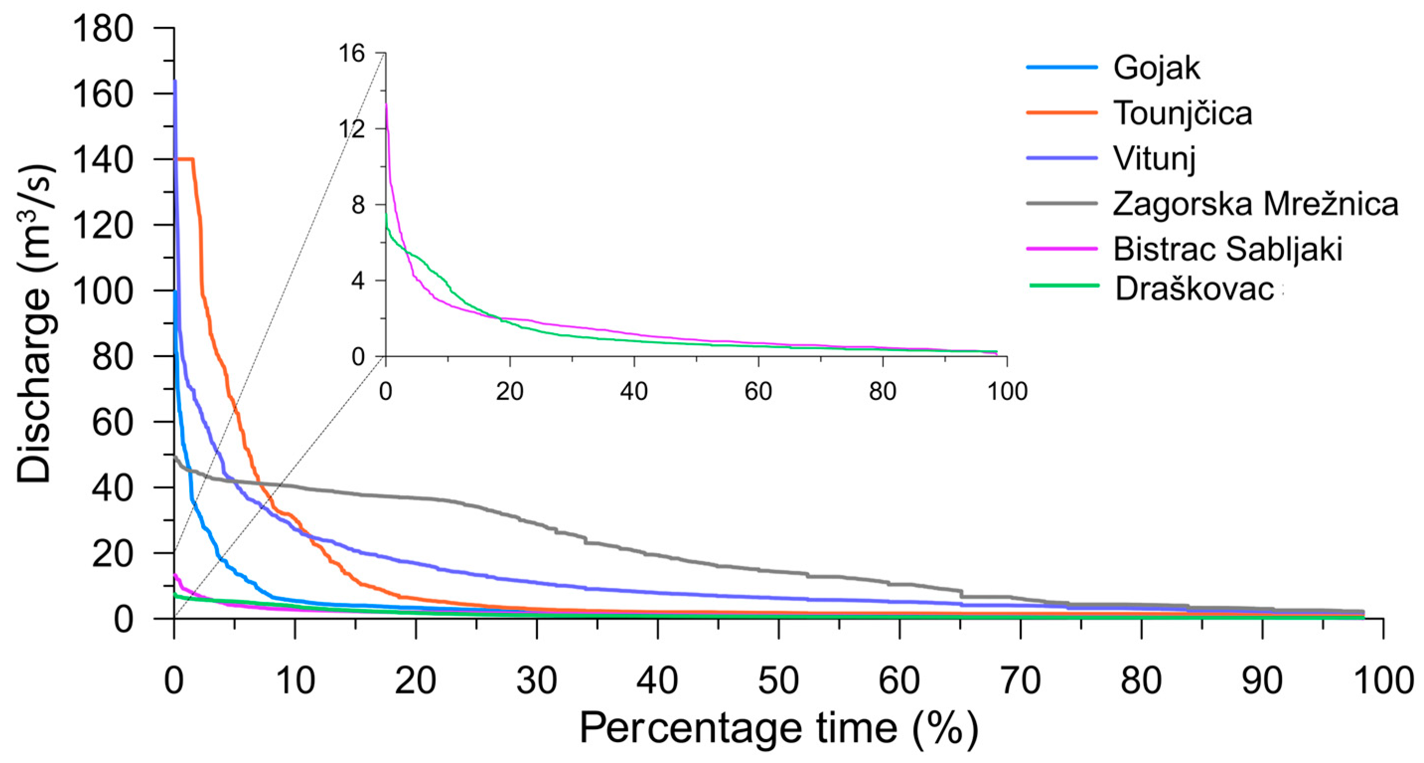
The hydrodynamic characteristics of the examined springs are effectively depicted through the configuration of their FDCs, which are based on daily discharge data (Figure 4). FDCs significantly oscillate at the aquifer outflows. The slopes of the FDCs of monitored springs indicate the predominance of two types of flow: a short, mixed time between rapid flow through a well-developed system of karst channels, typical for high-permeability karst, and diffuse flow, typical for low-permeability systems indicating water storage. However, notable differences in behavior are observed among the six springs. The Zagorska Mrežnica spring exhibits the longest duration of high discharge values. Nevertheless, based on earlier research [42], this does not reflect the karstification degree of the catchment area; rather, it signifies the influx of water from the flooded poljes in the hinterland and the limited outflow capacity. The Vitunj spring reaches five or more times the median discharge value of 9.4% for the year, equivalent to 34 days, with a peak discharge of 163 m3/s. Similarly, the Draškovac spring exceeds this threshold for 40 days throughout the year, with a peak of 7.5 m3/s, the Bistrac Sabljaki for 17 days with a peak of 13.3 m3/s, the Gojak for 21 days with a peak of 99.58 m3/s, the Tounjčica for 49 days with a peak of 140 m3/s, and the Zagorska Mrežnica for 133 days with a peak of 49.15 m3/s.
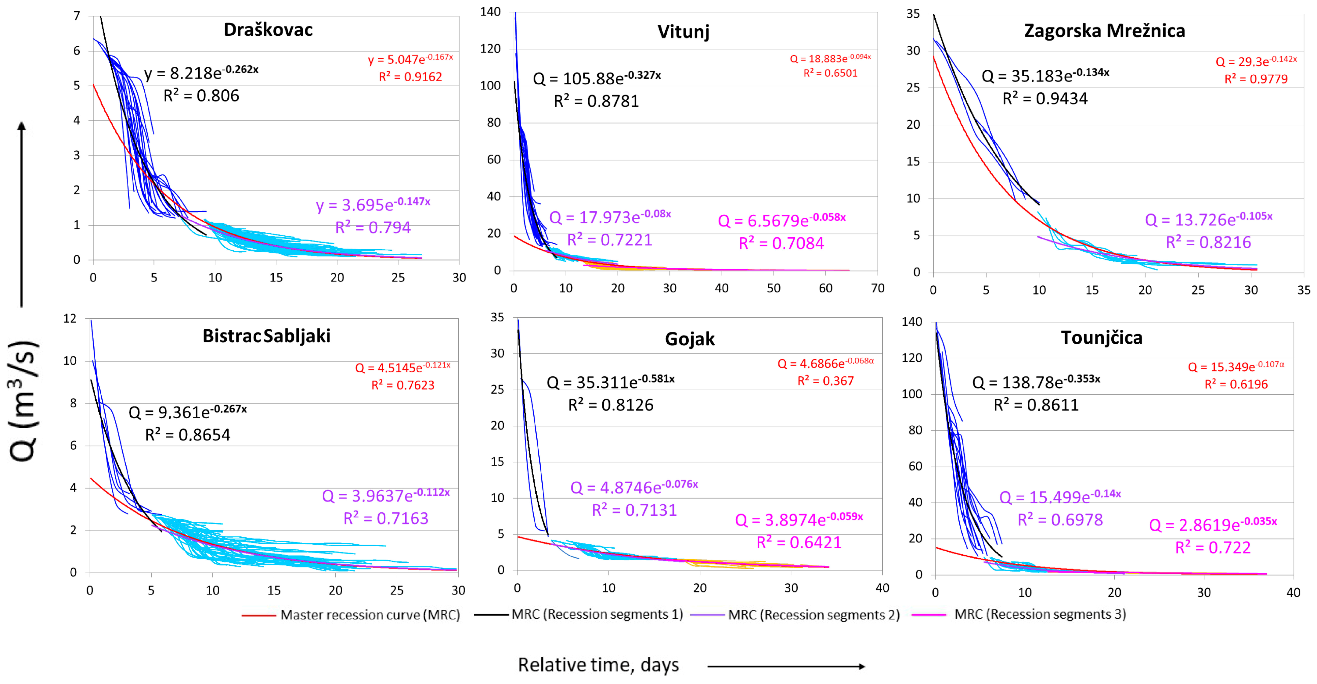
Exponential regression models were developed using the “matching-strip” method to estimate the α, enabling comparative analysis of the hydrogeological characteristics of the monitored springs catchments [65]. In the regression analysis of the Zagorska Mrežnica spring, discharge values exceeding 35 m3/s were excluded to ensure fidelity of the analyzed data in reflecting the degree of aquifer karstification, independent of the spring outflow capacity’s influence. Consequently, the lowest α value obtained for the Zagorska Mrežnica spring should be cautiously considered in interpretation. The recession curves are shown in Figure 5. Generally, the springs have two predominant sub-regimes, first described by α coefficients within the range of 10−1, indicative of rapid discharge through well-developed conduits, and second within the range of 10−2, suggesting an intermediate or mixed to diffuse flow regime with slower circulation in fractured rocks. The MRCs are divided into two or even three sub-regimes to enhance comprehension of the heterogeneous system, although, in these rocks, diffuse flow can be considered as being extremely low. The overview of recession curves in monitored springs are presented in Table 2.
Similarity in the regression models of two smaller springs situated at the foot of Kapela, the Bistrac Sabljaki and the Draškovec is emphasized. The first sub-regime for both springs is characterized by an α of 0.26, and the second is described with an α of 0.112 for the Bistrac Sabljaki and 0.147 for the Draškovac spring, respectively. Bistrac Sabljaki discharge changes regime at the critical point of 2.6 m3/s, while the Draškovac discharge regime changes at 1.1 m3/s. Both sub-regimes of the Zagorska Mrežnica aquifer are also characterized by an α higher than 10−2, the first one with 0.134 and the second one with 0.105. We assume that the first value is slightly reduced due to the exclusion of extreme values from the analysis. A regime change occurs at 8.3 m3/s. For other springs, models comprising three discharge sub-regimes were deemed more appropriate for comparing catchment characteristics. The Vitunj changes flow regime first at 13.2 m3/s, and subsequently at 4.9 m3/s, with an α value defined as 0.327 for high, 0.08 for medium, and 0.058 for low waters, as ascertained through automatic regression analysis. The time series for the Gojak and the Tounjčica exhibit the highest α values, suggesting a higher degree of karstification in the shallow karst zone. Discharge from the Gojak spring changes the flow regimes at 4.9 and 1.5 m3/s, with the highest α value of 0.581 for high, 0.076 for medium, and 0.059 for low waters. At the Tounjčica spring, change in the discharge regime appears at 10.1 and 1.6 m3/s, with high waters best described by α values of 0.353, medium waters by 0.14, and slower flow by an α value of 0.035.
The α values calculated for the six springs underscore the varying karstification degrees exhibited by the structural tectonic processes and lithologies forming the aquifer reservoirs, thereby indicating a higher karstification within the shallow karst. Furthermore, notable differences in flow velocities observed during distinct recession periods for the Draškovec and Bistrac Sabljaki springs yield different slopes of recession segments, suggesting recharge emanating from different areas within catchments, depending on the precipitation event location and the prevailing saturation levels of the aquifer [18].
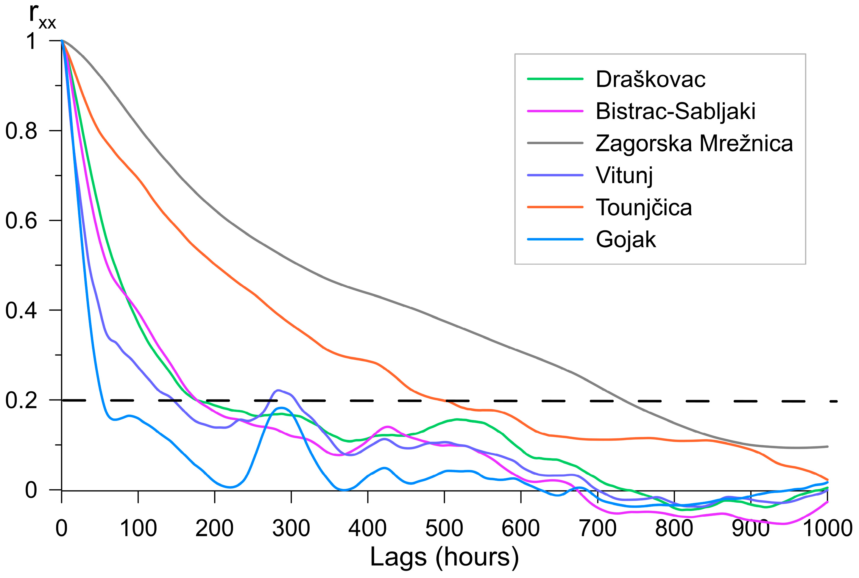
Short-term analyses often show a large dispersion of memory effect values due to variations in hydrological conditions [32,42,66]. To avoid this, the precipitation analysis was conducted using 5-year hourly discharge data. The ACF indicates different dynamics of the six monitored springs, characterized by different slopes of ACFs (Figure 6). At the Gojak and Vitunj springs, the ACFs exhibit the quickest decrease within the first 53 h, indicative of well-developed karst conduits facilitating rapid discharge flow. Subsequently, the Gojak spring reaches the threshold value of 0.2, defined as the average duration of the spring’s reaction to precipitation or the memory effect. Conversely, a second component is present in the ACF of the Vitunj, denoting a prolonged drainage period lasting from approx. 53 to 146 h before the system loses memory. The Bistrac Sabljaki and the Draškovac reflected similar system dynamics, with generally the same steep slopes of the function and memory loss after approx. 176 h. The Bistrac Sabljaki spring exhibits a short change in dynamics around 65 h, suggesting the activation of an additional system in the hinterland and marking the memory loss observed after 95 h.
The Zagorska Mrežnica and Tounjčica springs have significantly longer memory effects to the precipitation pulse. Specifically, the Zagorska Mrežnica spring shows memory loss after approx. 730 h or 30.5 days, while the downstream Tounjčica spring exhibits memory loss after approx. 495 h, or 10 days less. Generally, their ACF slopes follow each other without pronounced components. However, in Tounjčica’s ACF, a slight increase in discharge is discernible within the first 50 h, with a gentler slope compared to the Vitunj and Gojak springs.
Previous investigation of the ACF of the Zagorska Mrežnica spring, conducted between 2000 and 2013, divided into six-month intervals representing summer and winter seasons [42], resulted in no memory loss during winter periods. In a dataset spanning from 2018 to 2022, the same analysis resulted in memory effect values ranging from 5 to 30 days regardless of the season, probably due to the absence of snow cover during the winter season.
According to the theoretical values [28] and compared with other investigated karst systems within the Dinaric karst [25,30,33], the Gojak spring has an exceptionally rapid loss of memory, reaching 0.2 within 2.5 days. Similarly, the Vitunj, Bistrac Sabljaki and Draškovac springs experience memory loss within 6–7 days. A higher memory effect of 30 days was observed for the Zagorska Mrežnica spring and of 20 days for the Tounjčica spring, likely caused by the existence of intergranular sediment in the catchments and the limited outflow capacity of the Zagorska Mrežnica spring.
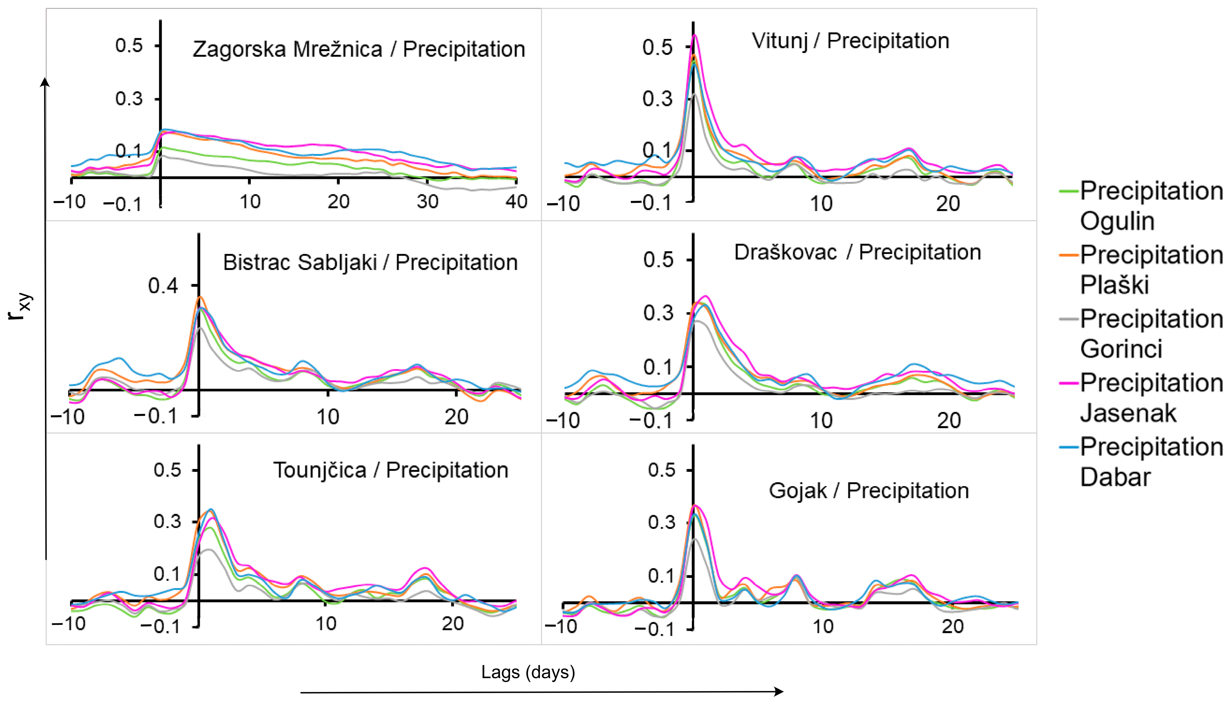
Figure 7 illustrates the positive crosscorrelations between precipitation recorded at five meteoric stations and the discharge observed at six springs. The daily response of the monitored springs to precipitation events indicates a very well-drained system. The correlation between Vitunj spring discharge and precipitations across all stations significantly surpasses that of other springs. The average delay between the Vitunj spring and rainfall in Jasenak is 12–22 h (CCF based on hourly data). The lowest correlation between precipitation and discharge was recorded at the Zagorska Mrežnica spring, with a maximum covxy of 0.2. The springs in the Dobra River basin, the Vitunj, Draškovac and Gojak, have the highest correlation with rainfall in the mountainous hinterland in the Jasenak polje. Conversely, the southern springs, including the Zagorska Mrežnica, Bistrac Sabljaki and Tounjčica, demonstrate a slightly more pronounced correlation with rainfall in the Dabar polje and Plaški. The Vitunj, Gojak and Bistrac Sabljaki have a simultaneous response to precipitation from all stations within a day of a rainfall event. The Zagorska Mrežnica spring shows positive correlations at a lag of 1 day for rainfall in the Dabar polje, and 2 days for rainfall in Jasenak. The Draškovac spring displays a response within a day to rainfall from its immediate stations and delays of 1 day from hinterland stations, the Dabar polje, and Jasenak. The Tounjčica spring reacts with a 1 day delay for all stations. Despite the lower correlation with precipitation in their immediate catchments, a comprehensive analysis of the hourly precipitation data was conducted due to the high correlation between the discharge of all springs and the precipitation from Jasenak (Figure 8).
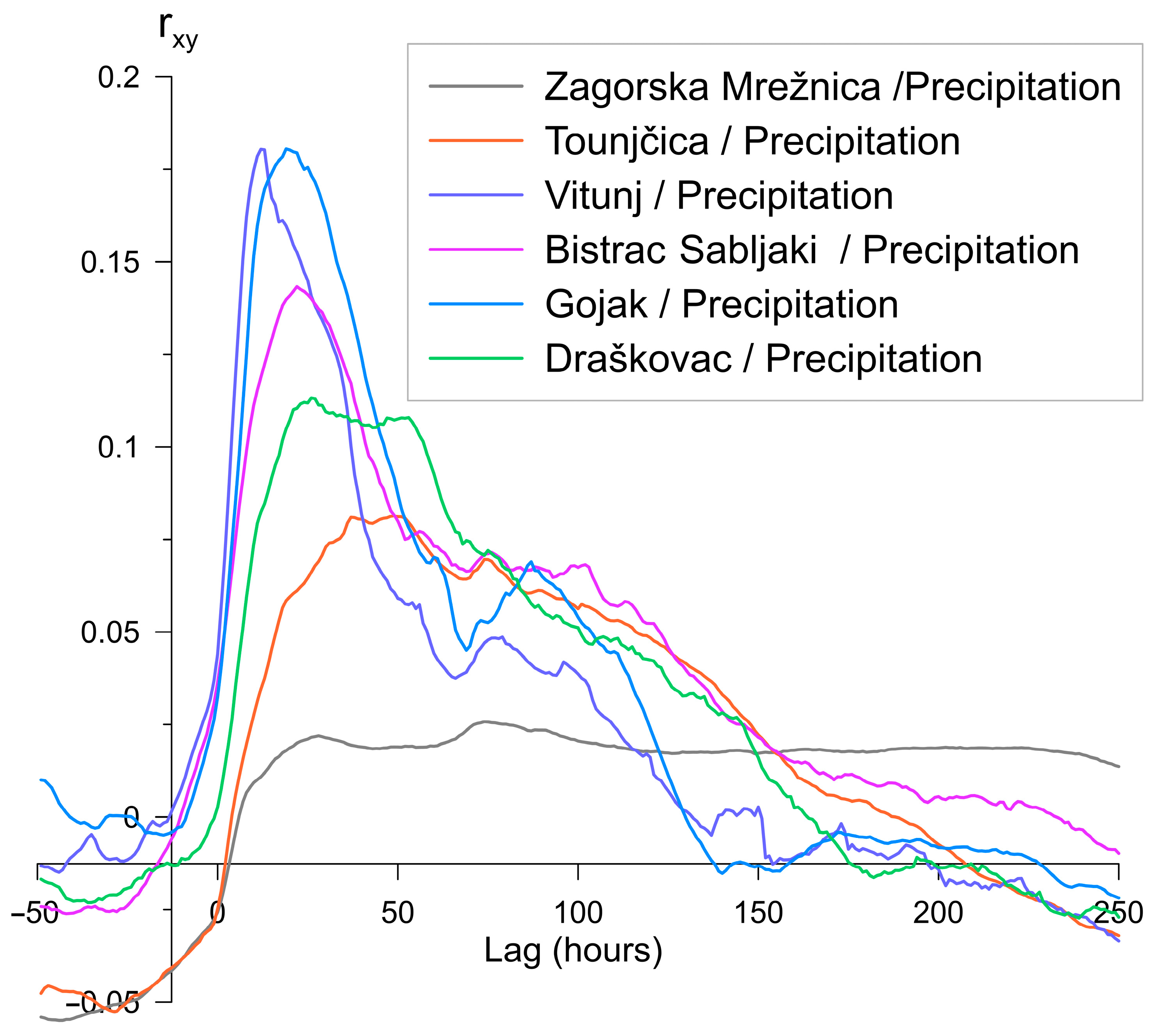
After rainfall, the first hydrograph peak with the highest correlation appears at the Vitunj spring with average delays of 8–16 h, where rxy = 0.18. With the same correlation, the water wave occurs at the Gojak spring after 4–6 h. The Bistrac Sabljaki spring has a slightly higher correlation, with rxy = 0.15, compared to the Draškovac karst system, with a 3–5 h faster response; it reacts approx. 18–26 h following rainfall in Jasenak. The CCF of the Draškovac karst system shows two reactions at the same event, with rxy = 0.1. The first reaction occurs with a delay of 21–30 h and the second one with a delay of 46–55 h. The rationale for this can be traced back to two springs that collectively supply the stream where the measuring station is located. The Tounjčica spring responds to Jasenak precipitation with delays of 37–52 h, with rxy = 0.08; while the Zagorska Mrežnica spring has the lowest correlation, rxy = 0.02, with Jasenak precipitation, with an average delay of 70–83 h.
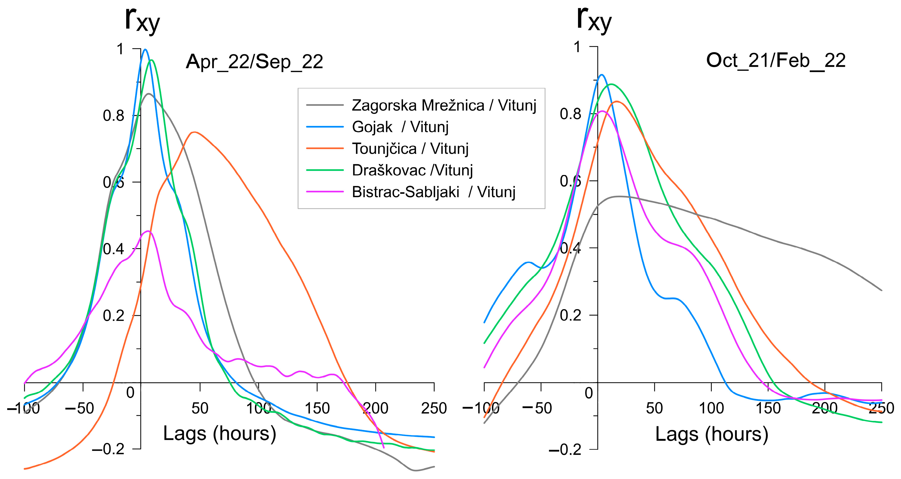
Since the CCFs between spring discharge depends on environmental variables like vegetation, hydrogeological properties, underground saturation, and precipitation quantity, the time series for the CCFs in different hydrological conditions were conducted between the Vitunj spring, which responds first to rainfall, and the other monitored springs (Figure 9). Regardless of the precipitation distribution and season, the correlation between the Vitunj spring and the downstream Gojak spring is expectedly strong, with a maximum correlation coefficient of rxy = 0.97 in the dry season and rxy = 0.91 in the wet season with a similar delay reaction of 3–6 h. The Draškovac reacts with the high correlation coefficient of rxy = 0.95 approximately 4–8 h after the Vitunj spring in the dry season and with a rxy = 0.88 during the wet season after approximately 8–16 h. The Zagorska Mrežnica and the Bistrac Sabljaki springs have opposite reactions in the same hydrological conditions. The Zagorska Mrežnica spring reacts quite simultaneously with a high rxy = 0.85 during low water conditions with the Vitunj spring, but during the wet season, the correlation is lower, rxy = 0.55, with a delay of 3–6 h. The Bistrac Sabljaki spring has a lower correlation, rxy = 0.44, during the dry season, and a higher correlation during the wet season, rxy = 0.81, with simultaneous reactions with the Vitunj spring. The average delay between the Tounjčica and Vitunj spring hydrograph peaks is 30–45 h with a lower correlation, rxy = 0.73, during low water conditions, while during high water conditions, the correlation is rxy = 0.83 and the average delay between peaks is shorter, 12–22 h.
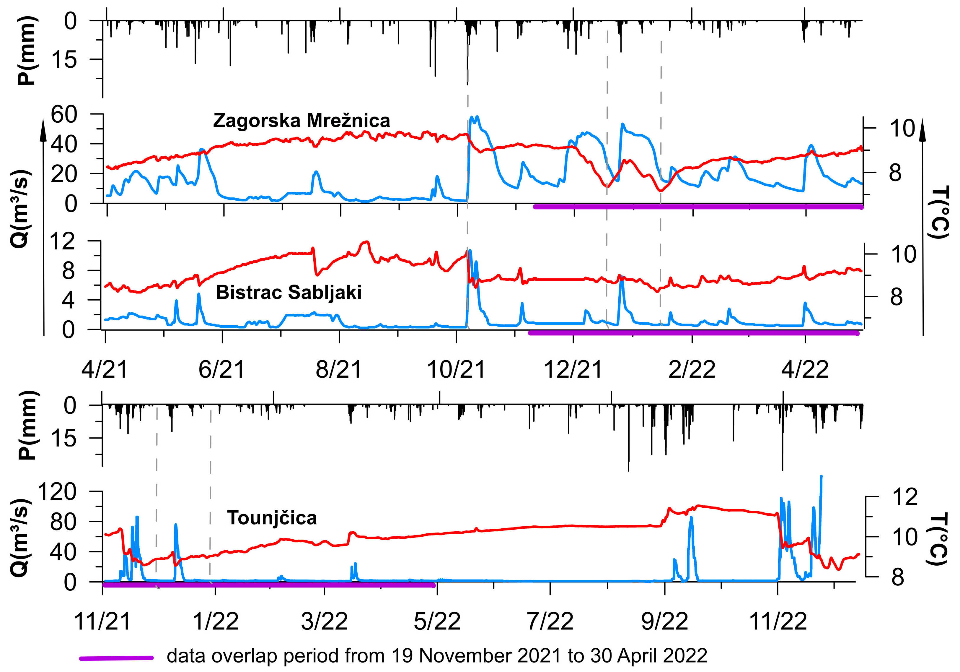
The water temperature was measured at all gauging stations. However, only at the Zagorska Mrežnica, Bistrac Sabljaki, and Tounjčica springs were the sensors positioned directly within the spring, ensuring that the temperature did not change under atmospheric temperature. The water temperature reflects the thermodynamics of the karst aquifer, giving insight into the dynamics and structural features of the hydrogeological system. The one-year undisturbed temperature variations are shown in Figure 10 and Table 3. All three aquifers exhibit two distinct patterns: long-term variations following the seasonal oscillations and short-term oscillations resulting from new recharge.
The water temperature in the Zagorska Mrežnica spring fell within the range from 7.17 to 9.85 °C, with a relatively high variation coefficient of 6.60%. The water flows through the aquifer without total homogenization caused by heat exchange between the rock and water, with a noticeable seasonal oscillation referring to influences of atmospheric conditions. Three flood events were recorded between October 2021 and January 2022. In October, after the dry season, the first heavy rainfall caused a decrease in the temperature before the hydrograph peak, proving that new water reaches the spring still in the rising phase of the hydrograph. The linear lowering of the temperature lasted during the maximum duration of the flow, with a decrease of 0.8 °C.
On 26 November 2021, at the beginning of the second flood event, the aquifer was moderately saturated, and the discharge began to increase six days before the decrease in temperature. The maximum discharge lasted for 16 days, the same as the temperature linearly decreasing, resulting in a temperature reduction of 1.7 °C. The third event started ten days later, with a temperature-decreasing delay of seven days with the same coincidence in the 15 day maximum flow and temperature drop duration with a temperature reduction of 1.4 °C. The minimum water temperature was recorded at the midpoint of the recession, after which the water temperature was rising towards the average temperature of the mountain region.
The hydrogeological structure of the terrain allows us to interpret fluctuations in the water temperature as a clear tracer of spring recharge. In the unsaturated aquifer, new infiltrated precipitation appears in the spring water within the first discharge impulse. In the saturated aquifer, fresh cold water appears with a lag of a few days, depending on the degree of saturation. In the case of complete saturation, the heavy rains caused the flooding of the karst poljes in the hinterland, where ponors are directly connected with the Zagorska Mrežnica spring [41]. The ratio of infiltrated colder surface water at spring outflow increases over time due to a decrease in the hydraulic pressure of the mountain rock mass, and its proportion would finally be insignificant after emptying the accumulation, which can be read in the rising water temperature after the flood event. Similar behavior can be observed in the temperature dynamics of the neighboring Bistrac Sabljaki spring, but only during the third flood event, when the aquifer was the most saturated. The gradual cooling of the spring water started 7 days after the temperature drop in the Zagorska Mrežnica spring, but ended at the exact moment when the accumulation was empty.
The water temperature in the Bistrac Sabljaki spring fluctuated from 8.2 to 10.6 °C. The coefficient of variation is relatively high: 5.92%. The water temperatures measured at the Tounjčica spring ranged from 8.4 to 11.6 °C, with the highest coefficient of variation of 7.7%. In both springs, the seasonal variations are evident, with a maximum temperature recorded at the end of summer or the dry period. The consistent response of the temperature to the change of flow indicates the fast water transfer through the system by well-developed conduits.
The short temperature rises before drops are likely linked to the release of water from narrow cracks with low permeability. This release is triggered by sudden increases in pressure resulting from the infiltration of precipitation, or it could be the activation of deep conduit flow due to a heightened hydraulic gradient within the system [67].
The mean annual groundwater temperature calculated for the Bistrac Sabljaki spring amounts to 8.8 °C, for the Zagorska Mrežnica spring, 9.0 °C, and for the Tounjčica spring waters, 10.1 °C. Calculating the average recharge height should consider the tempering of surface waters in the Zagorska Mrežnica catchment area. However, the mean temperature in the Bistrac Sabljaki is still lower than in the Zagorska Mrežnica spring, which indicates the preferred feed of the Bistrac Sabljaki spring by draining the mountain massif above, while the majority of the Zagorska Mrežnica catchment area is located behind the first mountain peak. The average recharge height of the Tounjčica spring is anticipated to be several hundred meters lower.

3.1. Hydrochemical of Groundwater

The chemical properties of the sampled water are presented in Table 4. All sampled water belongs to the Ca-HCO3 hydrochemical facies [68], indicating the carbonate aquifer without evaporates and other rocks. A low Mg concentration suggests groundwater has no significant retention in dolomites, which is expected due to large oscillations in the discharge. The bicarbonate is the dominant anion with an average contribution to the anion budget of ~95%. The mineralization of spring water during summer is lower, due to higher groundwater temperature. Lower nitrate and sulphate concentrations were observed during periods of high water levels, perhaps as a result of dilution. Regardless, the amounts of these substances are significantly lower than the maximum allowable limits, suggesting that the water being studied is of excellent quality.

3.2. Hidrogeological Conceptual Model of Karst System

The time series analyses provide detailed insights into the significant karst system dynamics. The FDC, RCA, and ACF delineated two types of reservoirs in the observed karst systems: well-developed karst conduit systems developed in size compared to fracture-matrix systems without clear diffuse flow. In the mountain massif, the Draškovac, Vitunj, and Bistrac Sabljaki aquifers have a similar behavior, indicating dominant drainage of higher mountain areas, from which the karst conduits are most developed in the Vitunj catchment area, characterized by a higher recession coefficient, discharge ratio, first reaction to the precipitation and a low memory effect. The Bistrac Sabljaki karst network is slightly more developed than the Draškovac aquifer. However, both aquifers respond a few hours after the Vitunj spring, practically simultaneously to precipitation, and lose memory simultaneously. The hydrograph of the Zagorska Mrežnica is not typical for a karst spring as it does not have discharge peaks (Figure 3); the high discharge is rather uniform, with low recession coefficients and a significantly longer memory effect, indicating direct connections with the poljes in the hinterland and a limited spring outflow.
Reviewing all available data and the research results is necessary to define the dynamics of a complex and highly karstified system. In the study area, 23 underground flow tracings have been done in the last 70 years, primarily focused on the Sabljaki catchment area and the Zagorska Mrežnica drinking water supply spring. Table 5 shows 18 tracing tests for which detailed data are available and considered in this interpretation. The results of the tracing tests show interesting and occasionally opposite data. Therefore, tracing tests of the same ponors showed a connection with different springs, but in different hydrological conditions. However, engineers questioned their reliability mainly due to the time lag and outdated techniques.
In the hinterland, the tracing tests in low and medium waters have established the connection between the Drežnica polje and a series of karst poljes. On the NW site from the Jasenak and Krakar, via the Drežnicki Lug to the Drežnica poljes; and on the SE site from the Stajnica polje, via Jezerane to the Crnac polje, without detecting the tracer in other springs. In general, during low waters, the shape of the tracer curve of the Zagorska Mrežnica spring was untypically symmetrical, pointing to the significant and uniform dispersion of tracers, longer retention in the underground, and relatively low velocity.
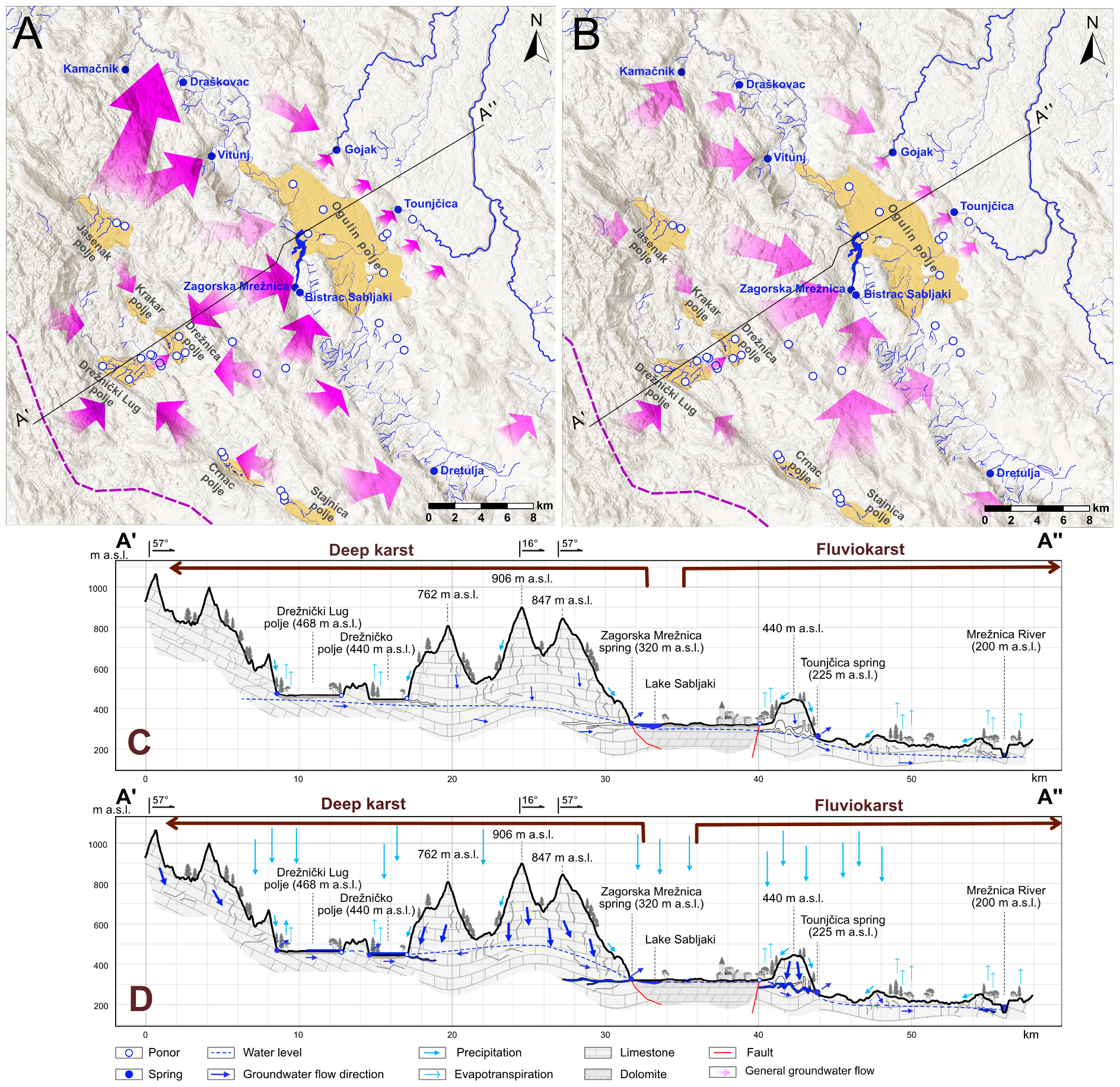
Figure 11 presents dynamics during (a) low and (b) high water conditions. In the dry seasons, the water drains the surrounding mountain from the boundary of the Adriatic/Black Sea catchment, with occasional surface flows in the poljes, and gravitates to the Zagorska Mrežnica springs. In the karst poljes, the vadose zone is not deeper than several tens of meters. Based on time series analysis and tracing results, the Draškovac, Vitunj, and Bistrac Sabljaki springs mainly drain the higher mountain massifs directly above them. On the other hand, during high waters, when the mountain massif is saturated, and the poljes are flooded, the tracers of the same ponors did not appear at the Zagorska Mrežnica spring. In 1972, on the NW, the Jasenak polje established connections in the north with the Kamačnik and Vitunj springs. The high correlation of precipitation in Jasenak with the Vitunj and Draškovac springs and the hydrogeological settings offer compelling evidence for this connection. In the same tracer test, lower tracer concentrations appeared in the Krakar polje in the south of the area, which undoubtedly gravitates towards the Drežnica polje and further towards the Zagorska Mrežnica, but probably due to dilution, it was not detected at the spring.
On the SE, the tracing test during high waters linked the ponor in Crnac polje with the Dretulja spring. The tracings conducted during high waters do not disprove the poljes relationship with the Zagorska Mrežnica spring. However, it is more likely that the absence of tracers is attributed to dilution in retentions, as demonstrated in the tracing experiments conducted in the Drežnica polje on the Kolovoz ponor in 1972 and Bosanić in 2013, when the traced sinkholes started acting as springs. The temperature dynamics of the observed springs show that the hydraulic potential in the mountain massif above the springs is higher than the hydraulic potential from flooded poljes during high water conditions, resulting in the potential runoff of the groundwater towards the peripheral springs, probably incorporating the Jasenak polje as part of the Vitunj catchment area, and the Crnac or Stajnica polje as part of the Dretulja catchment area. Conceptually, the four analyzed karst systems can be considered as a part of the common mountain karst system, in which the catchment area boundaries are zonal, based on the aquifer saturation degree in the high permeability tectonic-formed limestone, which is devoid of the significant hydrogeological barriers and precipitation distribution.
The highest degree of karstification is evident in the karst complex downstream of the Ogulin polje, in the catchment areas of the Gojak and Tounjčica springs. According to the trace tests, the velocity of the groundwater is up to 10 times faster than in the mountain area, which is proved by the recession coefficients and discharge ratios. The CCF and ACF indicate faster water exchange in the Gojak spring system than in the Tounjčica system. If the long pulse of precipitation is taken into account, the fracture-matrix systems component in the Tounjčica system has a significantly higher proportion than the Gojak system. Despite the absence of water in the main entrances to the cave systems throughout the dry season as a result of hydrotechnical interventions, the springs never dry, indicating good hydraulic connections with the immediate hinterland.
Shallow or fluviokarst zone has limited water circulation due to the thinner, highly permeable carbonate deposits than in the deep karst zone. Previously, the boundary between deep and shallow karst was only descriptively defined [69] as a transition zone from deep to shallow karst based on structural geological units. This investigation has shown that the hydrogeological characteristics of the area north of Kapela are significantly different from the deep karst zone, categorizing it as part of the shallow karst zone. This new boundary is depicted on the hydrogeological map (Figure 2).

4. Conclusions

By comparing the results of implemented methodologies, differences between two karst types within the study area were determined: (1) deep karst with karstification extending over several hundred meters, and (2) the shallow or fluviokarst with a karstification depth below 200 m.
The Kapela represents the northern part of the typical Dinaric deep karst area and presents the first recharge area formed by substantially fractured Mesozoic limestone and dolomites. The hydrogeological relations are intrinsically complex and caused by compressional tectonics. Due to numerous karstic forms, the area is characterized by rare and ephemeral surface watercourses, with occurrences solely in karst poljes. The geological structure often impedes the vertical movement of groundwater, resulting in the predominantly horizontal development of karst channels. Highly karstified rocks enable the accumulation of groundwater in great amounts. The springs are periodic and have large discharge oscillations, as typical of karst springs. Although numerous tracing tests have been carried out, the catchment areas of the observed springs, and thus the catchments of the main tributaries of the Kupa River, the Dobra and Mrežnica Rivers, have not been unambiguously delineated. The precipitation in the mountains is abundant, resulting in tracer dilution and challenging detection. The time series analyses show that the groundwater dynamics depend on hydrological conditions. The conducted time series analyses indicated that the catchment areas of the monitored springs could be more specifically delineated by obtaining the additional hourly data on water temperature, electrolytic conductivity, and the hourly precipitation data from all meteorological stations.
The zone of shallow karst begins in a sinking area on the NE edge of the dolomite hydrogeological barrier in the Ogulin polje. The watercourses sink in the area of highly permeable limestone and reappear at the surface after 5 to 15 km of around 100 m lower elevation in the recent erosional base of the main rivers in this area. The karst phenomena are highly represented by numerous horizontal caves, sinkholes, springs and river valleys. The conducted time series analyses established a significant difference between the areas of deep and shallow karst, suggesting a more developed karst network, faster water exchange, and shorter retention of groundwater in the shallow karst zone.
The fluvial or shallow karst area in Croatia extended from this study area on the west to the Pannonian basin on the east, without clear and exact defined boundaries. This paper suggests the definition of the western boundary of the shallow karst in Croatia and provides the groundwork for establishing the base for further research of this scientifically not-yet-investigated area.
The practical significance of this research is manifold. Firstly, by delineating the hydrological characteristics of the transition zone from deep to shallow karst, this study offers crucial insights into groundwater flow and storage in one of the most karstified regions of the Dinaric karst. Such insights are essential for effective water resource management in the area. Secondly, the development of a conceptual hydrogeological model that addresses historical discrepancies in groundwater tracing results provides a more accurate depiction of the underground water system. This aids in better management and prediction of groundwater behavior. Thirdly, through the characterization of new hydrogeological relationships concerning long-standing human interventions like dams, tunnels, and reservoirs, this research establishes a baseline condition for the area. This baseline is crucial for evaluating the impacts of these structures on groundwater dynamics and water quality, thus informing future environmental and developmental planning.
While the total capacity of drinking water far exceeds the needs of the population, the region faces challenges during increasingly frequent climatic extremes and rapid water flow through the system. Sustainable management is essential to ensure the long-term availability and quality of water resources. Despite no significant change in total annual precipitation, climatic extremes are becoming more frequent, resulting in longer dry periods and intensified precipitation events. In highly karstified areas, similar to the one in question, intensive precipitation fails to effectively recharge the aquifer and swiftly exits the system. The depletion of the aquifer is further compounded by the absence of snow cover, which gradually melts and fills smaller fractures, thereby promoting longer water retention within the aquifer.
Furthermore, this study highlights the significant quality of groundwater, underscoring the importance of preserving the region’s water quality for sustainable development and conservation efforts. Lastly, the integration of various time series analysis techniques, including RCA, FDC, ACF, and CCF, provides a dynamic framework that could serve as a basis for advanced simulations using AI algorithms in the future. This methodological approach can be applied to similar studies in other karst regions globally, significantly contributing to the broader field of hydrogeology.

Author Contributions

All authors contributed to the study conception and design. I.B.: Investigation, Conceptualization, Data curation, Methodology, Visualization, Writing—original draft. J.T.: Investigation, Conceptualization, Methodology, Supervision, Writing—review & editing. J.L.R.: Methodology, Writing—review & editing. Ž.D.: Investigation, Conceptualization, Methodology, Supervision, Writing—review & editing. A.S.: Investigation, Visualization, Writing—review & editing. All authors have read and agreed to the published version of the manuscript.

Funding

This work was funded by two projects: Croatian Electric Power Company (B2Z30-76/19), and the Interreg Danube CAMARO-D project (DTPT1-1-096-2.1), co-funded by the European Regional Development Fund.

Data Availability Statement

The datasets presented in this article are not readily available because the data are collected and the ownership of third party. Requests to access the datasets should be directed to the Croatian Electric Power Company and the Croatian Meteorological and Hydrological Service.

Acknowledgments

Authors would like to thank the anonymous reviewers for their careful review, which helped to improve the quality of the manuscript. The Croatian Geological Survey, Department of Hydrogeology and Engineering Geology supported this research (administrative and technical support and utilization of laboratory services). This paper is partly the result in the scope of the internal research project “NONa” at the Croatian Geological Survey, funded by the National Recovery and Resilience Plan 2021–2026 of the European Union—NextGenerationEU, and monitored by the Ministry of Science and Education of the Republic of Croatia. The authors express their gratitude to the Croatian Meteorological and Hydrological Service and the Croatian Electric Power Company for the provided data.

Conflicts of Interest

The authors declare no conflicts of interest.

References

  1. Ford, D.; Williams, P.D. Karst Hydrogeology and Geomorphology; John Wiley & Sons: Chichester, UK, 2007; p. 562. [Google Scholar]
  2. Goldscheider, N.; Drew, D. Methods in Karst Hydrogeology. In IAH International Contributions to Hydrogeology, 1st ed.; Taylor & Francis: London, UK, 2007; Volume 26, p. 264. [Google Scholar]
  3. Fiorillo, F. The Recession of Spring Hydrographs, Focused on Karst Aquifers. Water Resour. Manag. 2014, 28, 1781–1805. [Google Scholar] [CrossRef]
  4. Torresan, F.; Fabbri, P.; Piccinini, L.; Dalla Libera, N.; Pola, M.; Zampieri, D. Defining the hydrogeological behavior of karst springs through an integrated analysis: A case study in the Berici Mountains area (Vicenza, NE Italy). Hydrogeol. J. 2020, 28, 1229–1247. [Google Scholar] [CrossRef]
  5. Fiorillo, F.; Doglioni, A. The relation between karst spring discharge and rainfall by crosscorrelation analysis (Campania, Southern Italy). Hydrogeol. J. 2010, 18, 1881–1895. [Google Scholar] [CrossRef]
  6. Kovács, A.; Perrochet, P. A quantitative approach to spring hydrograph decomposition. J. Hydrol. 2008, 352, 16–29. [Google Scholar] [CrossRef]
  7. Panagopoulos, G.; Lambrakis, N. The contribution of time series analysis to the study of the hydrodynamic characteristics of the karst systems: Application on two typical karst aquifers of Greece (Trifilia, Almyros Crete). J. Hydrol. 2006, 329, 368–376. [Google Scholar] [CrossRef]
  8. Krešić, N. Quantitative Solutions in Hydrogeology and Ground-Water Modeling; Lewis Publishers: New York, NY, USA, 1997; 461p. [Google Scholar]
  9. Boussinesq, M.J. Essai sur la Theories des eax Courantes; Memoires Presentes par Divers Savants a l’Academie des Sciences de l’Institut National de France; Imprimerie Nationale: Paris, France, 1877; Volume XXIII. [Google Scholar]
  10. Boussinesq, M.J. Recherches the´oriques sur l’e´coulement des nappes d’eau infiltre´es dans le sol et sur le debit des sources. J. Mathématiques Pures Appliquées 1904, 10, 5–78. [Google Scholar]
  11. Maillet, E. Mécanique et Physique du Globe: Essai D’hydraulique Souterraine et Fluviale [Mechanics and Physiques of the World: An Essay of Subterranean and Fluviatile Hydraulics]; Hermann: Paris, France, 1905. [Google Scholar]
  12. Schoeller, H. Hydrodynamique dans le Karst. Hydrogeologie des roches fissure´es. In Actes du Colloque de Dubrovnik; IAHS-UNESCO: Paris, France, 1965. [Google Scholar]
  13. Atkinson, T.C. Diffuse Flow and Conduit Flow in Limestone Terrain in the Mendip Hills, Somerset, UK. J. Hydrol. 1977, 35, 93–110. [Google Scholar] [CrossRef]
  14. Malik, P. Assessment of regional karstification degree and groundwater sensitivity to pollution using hydrograph analysis in the Velka Fatra Mountains. Slovakia. Environ. Geol. 2007, 51, 707–711. [Google Scholar] [CrossRef]
  15. Krešić, N.; Bonacci, O. Spring discharge hydrograph. In Groundwater Hydrology of Springs: Engineering, Theory, Management, and Sustainability; Elsevier: Amsterdam, The Netherlands, 2010; Chapter 4; pp. 129–163. [Google Scholar] [CrossRef]
  16. Posavec, K.; Bačani, A.; Nakić, Z. A visual basic spreadsheet macro for recession curve analysis. Groundwater 2006, 44, 764–767. [Google Scholar] [CrossRef]
  17. Posavec, K.; Parlov, J.; Nakić, Z. Fully Automated Objective-Based Method for Master Recession Curve Separation. Groundwater 2010, 48, 598–603. [Google Scholar] [CrossRef]
  18. Posavec, K.; Giacopetti, M.; Materazzi, M.; Birk, S. Method and Excel VBA Algorithm for Modeling Master Recession Curve Using Trigonometry Approach. Groundwater 2017, 55, 891–898. [Google Scholar] [CrossRef] [PubMed]
  19. Kovács, A. Quantitative classification of carbonate aquifers based on hydrodynamic behaviour. Hydrogeol. J. 2017, 29, 33–52. [Google Scholar] [CrossRef]
  20. Bailly-Comte, V.; Ladouche, B.; Charlier, J.B.; Hakoun, V.; Maréchal, J.C. XLKarst, an Excel tool for time series analysis, spring recession curve analysis and classification of karst aquifers. Hydrogeol. J. 2023, 31, 240–2415. [Google Scholar] [CrossRef]
  21. Padilla, A.; Pulido-Bosch, A.; Mangin, A. Relative Importance of Baseflow and Quickflow from Hydrographs of Karst Spring. Groundwater 1994, 32, 267–277. [Google Scholar] [CrossRef]
  22. Krešić, N.; Stevanović, Z. Groundwater Hydrology of Springs: Engineering, Theory, Management, and Sustainability; Butterworth-Heinemann: Oxford, UK, 2010; 573p. [Google Scholar]
  23. Malík, P.; Vojtková, S. Use of recession-curve analysis for estimation of karstification degree and its application in assessing overflow/underflow conditions in closely spaced karstic springs. Environ. Earth Sci. 2012, 65, 2245–2257. [Google Scholar] [CrossRef]
  24. Kovács, A.; Perrochet, P.; Király, L.; Jeannin, P.Y. A quantitative method for the characterization of karst aquifers based on spring hydrograph analysis. J. Hydrol. 2005, 303, 152–164. [Google Scholar] [CrossRef]
  25. Kovačič, G. Hydrogeological study of the Malenščica karst spring (SW Slovenia) by means of a time series analysis. Acta Carsologica 2010, 39, 201–215. [Google Scholar] [CrossRef]
  26. Malík, P. Evaluating Discharge Regimes of Karst Aquifer. In Karst Aquifers—Characterization and Engineering. Professional Practice in Earth Sciences; Stevanović, Z., Ed.; Springer: Cham, Switzerland, 2015. [Google Scholar] [CrossRef]
  27. Verma, R.K.; Murthy, S.; Verma, S.; Kumar Mishra, S. Design flow duration curves for environmental flows estimation in Damodar River Basin, India. Appl. Water Sci. 2017, 7, 1283–1293. [Google Scholar] [CrossRef]
  28. Mangin, A. Pour une meilleure connaissance des systèmes hydrologiques a partir des analyses correlatoire et spectrale. J. Hydrol. 1984, 67, 25–43. [Google Scholar] [CrossRef]
  29. Chung, S.Y.; Senapathi, V.; Sekar, S.; Kim, T.H. Time series analyses of hydrological parameter variations and their correlations at a coastal area in Busan, South Korea. Hydrogeol. J. 2018, 26, 1875–1885. [Google Scholar] [CrossRef]
  30. Jemcov, I.; Petrič, M. Measured precipitation vs. effective infiltration and their influence on the assessment of karst systems based on results of the time series analysis. J. Hydrol. 2009, 379, 304–314. [Google Scholar] [CrossRef]
  31. Zhang, Z.; Chen, X.; Chen, X.; Shi, P. Quantifying time lag of epikarstspring hydrograph response to rainfall using correlation and spectral analyses. Hydrogeol. J. 2013, 21, 1619–1631. [Google Scholar] [CrossRef]
  32. Paiva, I.; Cunha, L. Characterization of the hydrodynamic functioning of the Degracias-Sicó Karst Aquifer, Portugal. Hydrogeol. J. 2020, 28, 2613–2629. [Google Scholar] [CrossRef]
  33. Stroj, A.; Briški, M.; Oštrić, M. Study of Groundwater Flow Properties in a Karst System by Coupled Analysis of Diverse Environmental Tracers and Discharge Dynamics. Water 2020, 12, 2442. [Google Scholar] [CrossRef]
  34. Pahernik, M. Prostorna gustoća ponikava na području Republike Hrvatske. Hrvat. Geogr. Glas. 2012, 74, 5–26. [Google Scholar] [CrossRef]
  35. Selak, A.; Boljat, I.; Reberski, J.L.; Terzić, J.; Čenčur, B.C. Impact of land use on Karst water resources—A case study of the Kupa (Kolpa) transboundary river catchment. Water 2020, 12, 3226. [Google Scholar] [CrossRef]
  36. Bahun, S. Geološka osnova hidrogeoloških odnosa krškog područja između Slunja i Vrbovskog (Geological basis of the hydrogeological relations in the karst area between Slunj and Vrbovsko). Geološki Vjesn. 1968, 21, 19–82. [Google Scholar]
  37. Lukač Reberski, J.; Kapelj, S.; Terzić, J. An estimation of groundwater type and origin of the complex karst catchment using hydrological and hydrogeochemical parameters: A case study of the Gacka river springs. Geol. Croat. 2009, 62, 157–178. [Google Scholar] [CrossRef]
  38. Lukač Reberski, J.; Marković, T.; Nakić, Z. Definition of the river Gacka springs subcatchment areas on the basis of hydrogeological parameters. Geol. Croat. 2013, 66, 39–53. [Google Scholar] [CrossRef]
  39. Biondić, B.; Biondić, R.; Kapelj, S. Karst groundwater protection in the Kupa River catchment area and sustainable development. Environ. Geol. 2006, 49, 828–839. [Google Scholar] [CrossRef]
  40. Pavlić, K.; Parlov, J. Crosscorrelation and Cross-Spectral Analysis of the Hydrographs in the Northern Part of the Dinaric Karst of Croatia. Geosciences 2019, 9, 86. [Google Scholar] [CrossRef]
  41. Terzić, J.; Stroj, A.; Frangen, T. Hydrogeological investigation of karst system properties by common use of diverse methods: A case study of Lička Jesenica springs in Dinaric karst of Croatia. Hydrol. Process 2012, 26, 3302–3311. [Google Scholar] [CrossRef]
  42. Buljan, R.; Pavlić, K.; Terzić, J.; Perković, D. A Conceptual Model of Groundwater Dynamics in the Catchment Area of the Zagorska Mrežnica Spring, the Karst Massif of Kapela Mountain. Water 2019, 11, 1983. [Google Scholar] [CrossRef]
  43. Bonacci, O.; Andrić, I. Impact of an inter-basin water transfer and reservoir operation on a karst open streamflow hydrological regime: An example from the Dinaric karst (Croatia). Hydrol. Process 2010, 24, 3852–3863. [Google Scholar] [CrossRef]
  44. HGI-CGS Arhive; Croatian Geological Survey: Zagreb, Croatia, 1948.
  45. Gajić-Čapka, M.; Perćec Tadić, M.; Patarcic, M. Digitalna godisnja oborinska karta Hrvatske. (A Digital Annual Precipitation Map of Croatia-m Croatian). Hrvat. Meteorološki Časopis (Croat. Meteorol. J.) 2003, 38, 21–33. [Google Scholar]
  46. Zaninović, K.; Srnec, L.; Perčec-Tadić, M. Digitalna godišnja temperaturna karta Hrvatske [A Digital Annual Temperature Map of Croatia—In Croatian]. Hrvat. Meteorološki Časopis (Croat. Meteorol. J.) 2004, 39, 51–58. [Google Scholar]
  47. Korbar, T. Orogenic evolution of the External Dinarides in the NE Adriatic region: A model constrained by tectonostratigraphy of Upper Cretaceous to Paleogene carbonates. Earth-Sci. Rev. 2009, 96, 296–312. [Google Scholar] [CrossRef]
  48. Tari, V. Evolution of the northern and western Dinarides: A tectonostratigraphic approach. Eur. Geosci. Union Stephan. Mueller Spec. Publ. 2002, 1, 223–236. [Google Scholar] [CrossRef]
  49. Schmid, S.M.; Bernoulli, D.; Fügenschuh, B.; Matenco, L.; Schefer, S.; Schuster, R.; Tischler, M.; Ustaszewski, K. The Alpine-Carpathian-Dinaridic orogenic system: Correlation and evolution of tectonic units. Swiss J. Geosci. 2008, 101, 139–183. [Google Scholar] [CrossRef]
  50. Vlahović, I.; Tišljar, J.; Velić, I.; Matičec, D. Evolution of the Adriatic Carbonate Platform: Palaeogeography, main events and depositional dynamics. Palaeogeogr. Palaeoclimatol. Palaeoecol. 2005, 220, 333–360. [Google Scholar] [CrossRef]
  51. Prelogović, E.; Aljinović, B.; Bahun, S. New data on structural relationships in the Northern Dalmatian Dinaride Area. Geol. Croat. 1995, 48, 167–176. [Google Scholar]
  52. Velić, I.; Sokač, B. Basic Geological Map of the Republic of Croatia 1:100.000; Sheet Ogulin; Croatian Geological Survey: Zagreb, Croatia, 1982. [Google Scholar]
  53. Šušnjar, M.; Bukovac, J.; Nikler, L.; Crnolatac, I.; Milan, A.; Šikic, D.; Griman, I.; Vulić, Ž.; Blašković, M. Basic Geological Map of the Republic of Croatia 1:100.000; Sheet Crikvenica; Croatian Geological Survey: Zagreb, Croatia, 1970. [Google Scholar]
  54. Bukovac, J.; Šušnjar, M.; Poljak, M.; Čakalo, M. Basic Geological Map of the Republic of Croatia 1:100.000; Sheet Črnomelj; Croatian Geological Survey: Zagreb, Croatia, 1983. [Google Scholar]
  55. Stroj, A.; Paar, D. Water and air dynamics within a deep vadose zone of a karst massif: Observations from the Lukina jama–Trojama cave system (−1,431 m) in Dinaric karst (Croatia). Hydrol. Process 2019, 33, 551–561. [Google Scholar] [CrossRef]
  56. Bočić, N.; Pahernik, M.; Mihevc, A. Geomorphological significance of the palaeodrainage network on a karst plateau: The Una–Korana plateau, Dinaric karst, Croatia. Geomorphology 2015, 247, 55–65. [Google Scholar] [CrossRef]
  57. Kovačević, A. Hydrogeological Features of Karlovac County. Master’s Thesis, University of Zagreb, Zagreb, Croatia, 2006. [Google Scholar]
  58. Karlović, I.; Pavlić, K.; Posavec, K.; Marković, T. Analysis of the hydraulic connection of the Plitvica stream and the groundwater of the Varaždin alluvial aquifer. Geofizika 2021, 38, 15–35. [Google Scholar] [CrossRef]
  59. Baedke, S.J.; Krothe, N.C. Derivation of effective hydraulic parameters of a Karst Aquifer from discharge hydrograph analysis. Water Resour. Res. 2001, 37, 13–19. [Google Scholar] [CrossRef]
  60. Milanović, P. Water regime in deep karst—Case study of the Ombla Spring drainage area. In Karst Hydrology and Water Resources, Proceedings of the U.S.-Yugoslavian Symposium, Dubrovnik, Croatia, 2–7 June 1975; Yevjevich, V., Ed.; Water Resources Publication: Littleton, CO, USA, 1981; pp. 165–191. [Google Scholar]
  61. Tallaksen, L.M. A review of baseflow recession analysis. J. Hydrol. 1995, 165, 349–370. [Google Scholar] [CrossRef]
  62. Urumović, K.; Duić, Ž.; Hlevnjak, B. Hydrogeological significance of recession coefficients at the example of Istrian springs. Rud.-Geološko-Naft. Zb. 2009, 21, 25–34. [Google Scholar]
  63. Trauth, M.H. MATLAB Recipes for Earth Sciences; Springer: Berlin/Heidelberg, Germany, 2015. [Google Scholar]
  64. Liu, L.; Chen, X.; Xu, G.; Shu, L. Use of hydrologic time-series data for identification of hydrodynamic function and behavior in a karstic water system in China. Hydrogeol. J. 2011, 19, 1577–1585. [Google Scholar] [CrossRef]
  65. Taylor, C.J.; Green, E.A. Hydrogeologic characterization and methods used in the investigation of karst hydrology. In Field Techniques for Estimating Water Fluxes Between Surface Water and Groundwater; Techniques and Methods 4–D2; U.S. Geological Survey: Reston, VA, USA, 2008; pp. 75–114. [Google Scholar]
  66. Guo, Y.; Wang, F.; Qin, J.D.; Zhao, F.Z.; Gan, F.P.; Yan, B.K.; Bai, J.; Muhammed, H. Hydrodynamic characteristics of a typical karst spring system based on time series analysis in northern China. China Geol. 2021, 4, 433–445. [Google Scholar] [CrossRef]
  67. Kuhta, M.; Stroj, A.; Brkić, Ž. Hydrodynamic characteristics of Mt. Biokovo foothill springs in Croatia. Geol. Croat. 2012, 65, 41–52. [Google Scholar] [CrossRef]
  68. Boljat, I.; Terzić, J.; Duić, Ž.; Lukač Reberski, J.; Selak, A.; Briški, M. Tracing Hydrological Processes: Insights from Hydrochemical and Isotopic Investigations in the Northern Part of Croatian Dinaric Karst. Geol. Croat. 2024; in progress. [Google Scholar]
  69. Herak, M.; Bahun, S.; Magdalenić, A. Pozitivni i negativni utjecaji na razvoj krša u Hrvatskoj (Positive and negative influences on the development of the Karst in Croatia). Jugosl. Akad. Znan. I Umjet. Odjel Za Prir. Nauk. 1969, 6, 45–71. [Google Scholar]
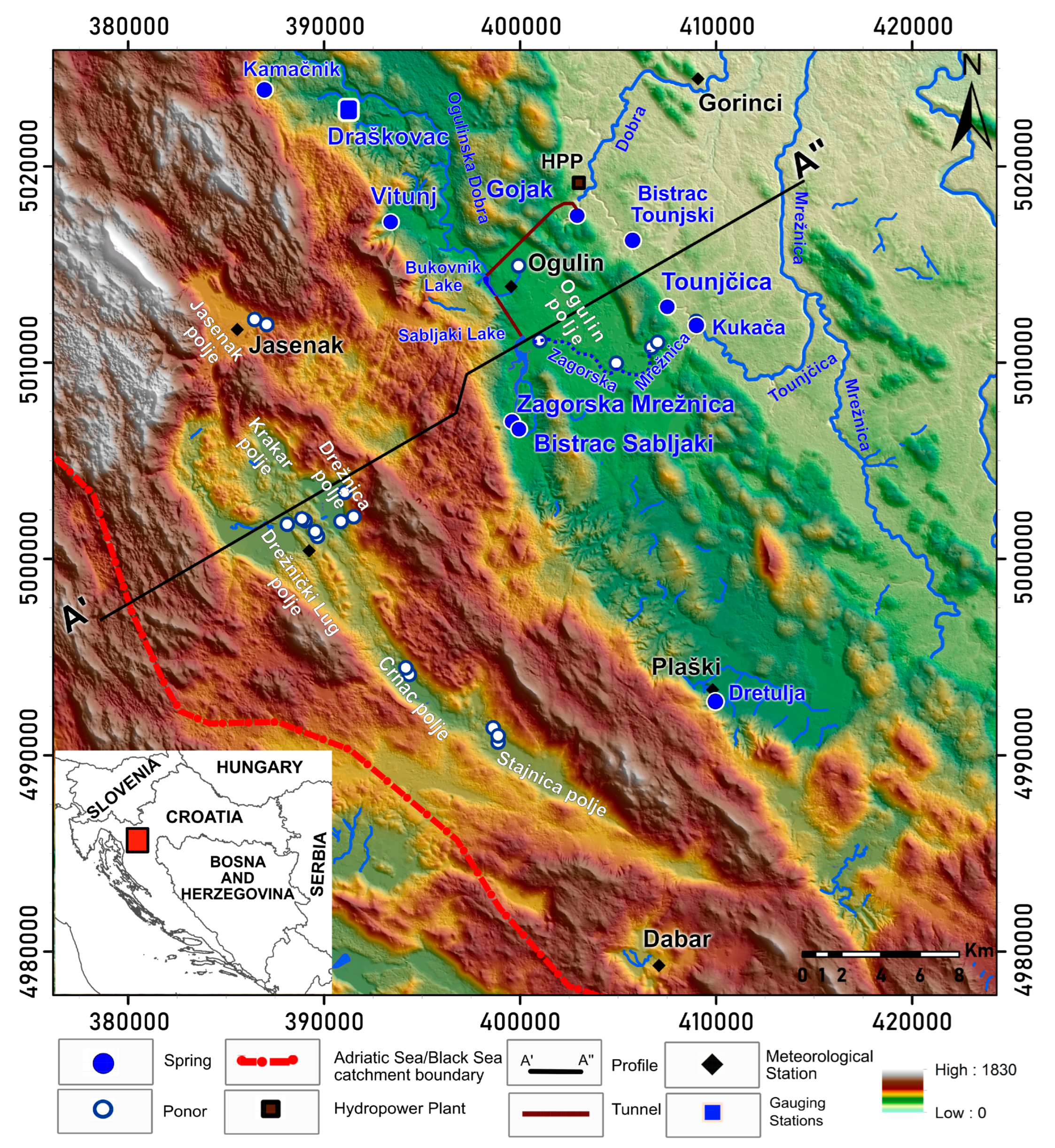
Figure 1. Location of the north Dinaric karst in Croatia (hillshade map modified according to Geoportal. Državna geodetska uprava. Available online: https://geoportal.dgu.hr/ (accessed on 19 December 2023).
Water 16 01630 g001
Figure 2. Hydrogeological map of the north Dinaric karst in Croatia (Modified according to [42]).
Water 16 01630 g002
Figure 3. The discharge data of the Vitunj, Draškovac, Gojak, Zagorska Mrežnica, Bistrac Sabljaki and Tounjčica springs from January 2018 to 2022.
Water 16 01630 g003
Figure 4. The flow duration curves of daily data for Vitunj, Draškovac, Gojak, Zagorska Mrežnica, Bistrac Sabljaki and Tounjčica springs.
Water 16 01630 g004
Figure 5. Recession analyses of the Vitunj, Draškovac, Gojak, Zagorska Mrežnica, Bistrac Sabljaki and Tounjčica springs.
Water 16 01630 g005
Figure 6. Autocorrelation function in Vitunj, Draškovac, Gojak, Zagorska Mrežnica, Bistrac Sabljaki and Tounjčica springs.
Water 16 01630 g006
Figure 7. Crosscorrelation between the discharge of six monitoring springs and five meteorological stations in the wider study area between January 2018 and December 2022.
Water 16 01630 g007
Figure 8. Crosscorrelation function between the discharge of all springs and rainfall in Jasenak.
Water 16 01630 g008
Figure 9. Crosscorrelation between the discharge of the Vitunj spring and Draškovac, Gojak, Zagorska Mrežnica, Bistrac Sabljaki, and Tounčica springs.
Water 16 01630 g009
Figure 10. Detailed dynamics of the Bistrac Sabljaki, Zagorska Mrežnica and Tounjčica water springs temperature and discharge.
Water 16 01630 g010
Figure 11. Conceptual map of interpreted regional groundwater flow directions during (A) high and (B) low water conditions, and a cross-section profile through the study area in low (C) and high (D) water conditions.
Water 16 01630 g011
Table 1. The basic statistical parameters for the springs’ discharge.
Vitunj
(m3/s)
Zagorska Mrežnica
(m3/s)
Bistrac Sabljaki
(m3/s)
Gojak
(m3/s)
Draškovac
(m3/s)
Tounjčica
(m3/s)
QMin0.300.300.100.300.100.20
QMax163.7849.1513.3099.587.50140.00
Qavg9.0714.161.393.131.067.98
Qmedian4.277.410.851.500.510.54
Ϭ sd14.0714.541.577.221.4021.75
QMin:Qmed:QMax1:14:5461:25:1641:9:1331:5:3321:5:751:3:700
Table 2. Recession equations of monitored springs.
SpringsRecession Segment 1 CurveRecession Segment 2 CurveRecession Segment 3 CurveMaster Recession Curve
Vitunj Q = 105.88 e 0.327 x Q = 17.973 e 0.08 x Q = 6.568 e 0.058 x Q = 18.883 e 0.094 x
Zagorska Mrežnica Q = 35.183 e 0.134 x Q = 13.726 e 0.105 x / Q = 29.3 e 0.142 x
Bistrac Sabljaki Q = 9.36 e 0.27 x Q = 3.96 e 0.112 x / Q = 4.51 e 0.121 x
Draškovac Q = 8.218 e 0.262 x Q = 3.695 e 0.147 x / Q = 5.047 e 0.167 x
Tounjčica Q = 138.78 e 0.353 x Q = 15.499 e 0.14 x Q = 2.862 e 0.035 x Q = 15.349 e 0.107 x
Gojak Q = 35.311 e 0.581 x Q = 4.8751 e 0.076 x Q = 3.897 e 0.059 x Q = 4.69 e 0.068 x
Table 3. The temperature parameters of groundwater in Zagorska Mrežnica, Bistrac Sabljaki and Tounjčica springs.
Zagorska Mrežnica Bistrac Sabljaki Tounjčica
MIN7.178.208.36
MAX9.8510.5811.55
Mean8.968.8510.09
Average8.909.0610.03
SD0.590.520.78
CV6.60%5.92%7.72%
Table 4. The chemical composition of groundwater in Draškovac, Vitunj, Zagorska Mrežnica, Bistrac Sabljaki, Gojak and Tounjčica springs.
Sampled SpringDateCa2+ (mg/L)Mg2+
(mg/L)
Na+
(mg/L)
HCO3
(mg/L)
Cl
(mg/L)
NO3
(mg/L)
SO42−
(mg/L)
Draškovac10 July 2019 *58.2023.641.522542.416.086.09
12 February 2020 **58.5522.760.672721.875.665.42
28 January 2021 ***52.4916.260.982561.803.501.99
Vitunj10 July 2019 *55.757.10.631661.224.75.69
12 February 2020 **55.015.770.731991.445.245.18
28 January 2021 ***51.3720.930.442211.041.352.23
Zagorska Mrežnica10 July 2019 *73.908.011.762622.744.776.76
12 February 2020 **71.029.411.452542.044.536.47
28 January 2021 ***65.805.882.122573.172.191.98
Bistrac Sabljaki10 July 2019 *64.5721.692.553253.975.598.30
12 February 2020 **67.6219.133.142904.024.737.09
28 January 2021 ***63.0014.392.812684.742.792.74
Tounjčica10 July 2019 *65.617.861.411812.217.456.65
12 February 2020 **73.898.351.682642.295.645.95
28 January 2021 ***66.867.871.992433.123.072.51
Gojak10 July 2019 *68.4111.043.271833.985.717.20
12 February 2020 **59.9314.124.542395.646.456.74
28 January 2021 ***60.6610.275.232337.744.873.54
Notes: * low water, ** medium water, *** high water.
Table 5. Tracing tests in the north Dinaric karst.
Location of Tracing TestInjection LocationSpring of the Tracer DetectionCalculate Flow Rate
(cm/s)
Emergence of Tracer
(h)
Water Conditions
Jasenak polje South ponor, 1972Kamačnik
Vitunj
2.4
1.6
130
144
High water
100 L/s
South ponor, 1986Zagorska Mrežnica Bistrac0.86
0.85
448
456
Low water
12.8 L/s
Drežnica poljeKolovoz, 1972Pećina
Bistrac
1.6
1.9
162
146
High water 6 m3/s
Potočak, 1980Zagorska Mrežnica1.73167Low water 17.3 L/s
Pražića jaruga, 1985Zagorska Mrežnica
Bistrac
2.9
2.9
88
88
High water 3–4 m3/s
Zrnića, 1981Zagorska Mrežnica Pećina3.480End of the water wave
Bosanić, 2013- Flood
Drežnički LugPećina Maravić Dragi, 1980Pećina Sušik0.5543Low water
Stajnica poljeJaruga-Jezerane, 2002Rokina Bezdani2.3624Medium water
Jezerane ponor, 1988Zagorska Mrežnica
Bistrac Sabljaki
1.36
1.21
320
344
5 L/s
Jaruga-Jezerane, 2000Zagorska Mrežnica
Bistrac
1.53
1.38
284
308
80–100 L/s
Crnac polje1972Dretulja2.3182High water
1985Zagorska Mrežnica Bistrac2.3
2.16
160
173
Low water 150–200 L/s
Ogulin poljeĐula ponor, 1948Gojak5.6823.452 m3/s
Zagorska Mrežnica watercours, 1948Bistrac Sabljaki
Tounjčica
Kukača
10.2
5.5
11.7
18.45
32.55
18.25
9.37 m3/s
Zagorska Mrežnica watercourse, 1948Bistrac Sabljaki
Tounjčica
Kukača
11.76
6.97
6.17
15.98
28.45
37.25
13.20 m3/s
Disclaimer/Publisher’s Note: The statements, opinions and data contained in all publications are solely those of the individual author(s) and contributor(s) and not of MDPI and/or the editor(s). MDPI and/or the editor(s) disclaim responsibility for any injury to people or property resulting from any ideas, methods, instructions or products referred to in the content.