Abstract
Human activities play a key role in landscape evolution. Mining is one of the most important of these since it changes large parts of the Earth’s surface. In abandoned mines and quarries, pit lakes are quite common due to water table blocking. These lakes have remarkable ecological characteristics, but they are still poorly understood. Northwestern Spain has a long tradition in the use of slate for roofs. This exploitation, mostly open-pit, has caused a great transformation in the landscape including the generation of pit lakes. In this work, 27 pit lakes in abandoned slate quarries areas have been analysed using orthophotos of different years, UAV (unmanned aerial vehicle) images and field work. In each lake, the topographic context, geomorphological dynamics, morphometric parameters (including depth), pH, and ecological variables were measured. Other uses for these quarry pit lakes and their significance as a new geo-ecological environment are also discussed. The results show different types of pit lakes and, consequently, different potential uses in each case. Only six offer good conditions for recreational uses, whereas the rest (21) show slope instability or poor water quality.
1. Introduction
Open-pit mining is a major driver of anthropic changes in topography [1,2] and landscape [3]. Extensive use of machinery and blasting can often dismantle entire mountains and generate severe environmental impacts [4,5,6,7]. Conversely, the use of post-mining areas as sites of heritage value has become a relevant topic in recent decades [8,9,10,11,12,13], including some areas of Spain [14,15,16].
One of the most unique features of open-pit mining is the formation of pit lakes. These water bodies represent a radical and permanent alteration of the landscape compared to the pre-operational state [17,18]. The terminology for these lakes varies, including strip mine lakes [19], pit lakes [20,21] and post-mining lakes [22,23]. Nonetheless, they all reflect significant transformative effects on natural conditions and introduce a distinct and lasting change in the landscape [24]. The enduring nature of these changes [25] makes pit lakes a prominent example of human impact on topography [26,27].
The continuous open-pit mining of various minerals and rocks in northwestern Spain has resulted in the creation of numerous pit lakes. Examples include water bodies formed in historic gold, coal, sand, alluvium, and slate mines. All these water bodies share the common feature of occupying the bottoms of old, abandoned mining sites [25,27,28]. The water can originate from different sources: groundwater [28], direct precipitation, surface runoff from the surrounding basin, or a combination of multiple factors [29].
Pit lakes in slate quarries are formed after the mines are abandoned and subsequently flooded. These depressions on the surface constitute small, closed basins characterised as endorheic [28]. Occasionally, a drainage channel is constructed to evacuate the excess of water from the pit lake [17,27].
Spain is one of the leading producers of roofing slate in the world and has exploited slate for some centuries [30]. In northwestern Spain, slate has historically been used for building roofs [31,32]. Traditionally, slate was extracted in an artisanal manner. Industrial exploitation commenced in the mid-20th century [33,34], when the largest slate deposit in Western Europe was discovered. The abundant reserves and high quality of the rock have enabled continuous exploitation to supply roofing slates to European and North American markets.
Mining, most of which is open-pit, has significantly transformed the landscape of the slate mining areas in the provinces of Orense [34,35] and León [21], and has generated some geological risks [36]. This includes, although with less extensive changes, mines in Zamora, Lugo, and La Coruña. In these regions, the pit lakes are among the most distinctive features of abandoned quarries.
These wetland areas are generally unknown, even to local residents. They are not often mapped in inventories or on maps, leading to their undervaluation and underutilisation. Moreover, these pit lakes are often viewed as an insignificant part of the mining landscape. However, many are located near important Protected Natural Areas, such as Sierra de Caurel [37], Sierra de la Culebra, Ancares, La Cabrera [38], and Trevinca, as well as the Ortigueira estuary. Owing to their low valuation, they are considered to be marginal lands of the old, abandoned mines.
A total of 27 pit lakes in abandoned slate quarries were analysed in this study (Figure 1, Supplementary Materials). Although some more exist, they could not be examined as their location within or proximity to active quarries makes them inaccessible. All these pit lakes resulted from the extraction of ornamental slate, but their morphological and water characteristics are different. Additionally, their specific location, proximity to inhabited areas, age, and accessibility conditions, among other factors, make each of them a unique mining legacy. Some experiences in Wales, where slate landscape, including pit lakes, has been listed as a World Heritage Site by UNESCO [39,40], or the valorization of slate quarries in Belgium [41], indicate the potential value of the slate mining of NW Spain. Therefore, their future use will require a personalised approach [18,42].
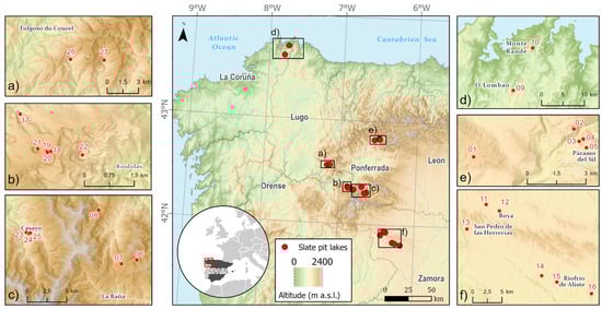
Figure 1.
Location of abandoned slate quarry pit lakes in northwestern Spain. More detailed mapping can be seen in Supplementary Materials.
This study aims to characterise the morphometric and basic quality parameters of the waters in these pit lakes, identifying common patterns and unique features that distinguish them. The data gathered will enhance the understanding of mining lakes in northwestern Spain and contribute to a broader project that began with analysing similar parameters in open-pit coal mining lakes in León [28]. Additionally, this study explores the potential uses of these spaces, such as water storage for various purposes, recreational activities, wildlife habitats, waste storage [42], and geological or geomorphological heritage sites. Therefore, the objective of this work was to highlight their significance as a new geo-ecological environment.
2. Materials and Methods
To determine the transformation caused by mining exploitation, multi-temporal remote sensing data are required. This approach enables monitoring land use, changes in land use, and landscape status [26,43,44,45]. Such methods are particularly relevant for the exploitation of ornamental slate. The existing slate quarries in northwestern Spain and the pit lakes within them were identified by analysing panchromatic aerial photos (1945–1946 American flight [A Series], 1956–1957 American flight [B Series], 1973–1986 Interministerial Flight, and 1980–1986 National Flight), as well as recent orthoimages (https://fototeca.cnig.es/fototeca/, accessed on 1 July 2024).
Using the ArcMap 10.6 application of the ArcGIS software, the pit lakes were delineated, and the following morphometric parameters were calculated: S, surface area, delimited by the contour of the pit lake; P, perimeter, or the length of the pit lake’s shoreline, which remains almost constant throughout the year; L, maximum length, the line connecting the two farthest points on the pit lake’s shore [46]; and W, maximum width, defined as the maximum distance along a straight line perpendicular to the maximum length line [47]. These dimensions are commonly used in limnology studies [46,47,48,49,50].
The fieldwork involved recognising and verifying the gaps in the abandoned slate quarries that were previously identified through photointerpretation. Basic parameters that could not be obtained in the lab were measured on-site, including the maximum depth (Z) and average depth (ZZ) [28]. A sonar device (Deeper Chirp + 2 Smart Sonar) with a range of 100 m of distance and 80 m of depth was used for the measurements. Additionally, water samples were collected from the pit lake surface to measure pH—a key parameter for determining the geo-ecological condition of these waters. The Basic 20 benchtop pH meter (CRISON) was employed following the standard procedure. Data on the general environmental status and stability of the pit lake surroundings were recorded. Finally, when accessibility was limited, zenithal images were captured using a UAV (DJI Mavic 3) to obtain an overall view of the pit lake.
Using the collected data, the water volume (V) was estimated based on the mean depth and surface area [47]. The waterbody development index (DL), which indicates the pit lake’s contour, was calculated using the following formula: DL= P/2 √π A [47,51]. The categories for this index include circular (1 < DL ≤ 1.25), subcircular (1.25 < DL < 1.5), elongated subrectangular (1.5 < DL < 3), and dendritic (DL > 3) [47,51,52]. All morphometric data were stored in a database for treatment and statistical analysis.
3. Results
The pit lakes studied are located in the provinces of Orense (9), León (8), Zamora (6), La Coruña (2), and Lugo (2) (Figure 1 and Figure 2, Table 1, Supplementary Materials). Most of these pit lakes are situated in mountainous areas, at altitudes between 600 and 1500 m, except for those in La Coruña.
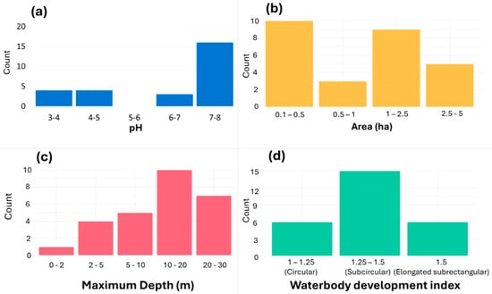
Figure 2.
(a) pH groups of the pit lakes. (b) Surface (ha) groups. (c) Maximum depth of the pit lakes. (d) Waterbody development index groups of the pit lakes.

Table 1.
Analysis of characteristics of the mining pit lakes.
Of the 27 pit lakes analysed, 17 are located at the bottom of a valley, coinciding with the talweg of the old valley. In a few cases, they share the lower part of a slope with a margin of the valley floor (Table 1). The remaining pit lakes are located on valley slopes. This preferential location could be attributed to the fact that the gentler slope along the talweg facilitates mining activities. Additionally, as morphogenesis has exposed the rock, access has improved and a lower volume of surface formation has to be removed. However, this location also presents certain disadvantages. As mining operations move deeper into the massif, they are more likely to intercept water tables. Furthermore, runoff water may enter directly into the quarry, necessitating pumping to continue mining activities.
Conversely, the proximity of watercourses to the bottom of the quarry, or their concurrence, implies the emission of water from the operation outside the quarry into the natural watercourses. When the quarry is abandoned and the pit lake is formed, its waters can overflow the artificial enclosure that confines the waters. When the flow is constant, they flow directly through a small drainage channel into the natural channel (PI 15; Figure 3a; Figure 8a; PI 21), especially when they are located at the bottom of a valley. Thus, 18 of the pit lakes lack connectivity to natural channels (67%). They are endorheic areas with no water outlet to runoff and are typically located on slopes (Figure 3b). The remaining nine pit lakes (33%) have functional water outlets and are located at the bottom of the valley (Table 1).
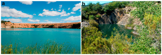
Figure 3.
(a) PI 15 in Palazuelo (Zamora), encompassing an area of 4.9 ha, is the largest of all the pit lakes studied; (b) On the right, PI 05 in Páramo del Sil is smaller in size (0.25 ha), but it exhibits natural characteristics and a neutral pH, and supports ichthyofauna.
Regarding the pH value of the waters (Table 1, Figure 2a), eight of the pit lakes present pH values equal or below 5.0. Seventeen pit lakes display pH values above 7 (13 > 7.5), while only three are between 5.0 and 7.0. As illustrated in Figure 2, the distribution of pH values tends to be concentrated above 7.0. Moreover, there are more pit lakes that tend toward alkalinity than acidity.
The pit lakes studied are relatively small in size, with 13 of them encompassing areas between 0.1 and 0.7 ha, and 13 pit lakes ranging from 1 to 4 ha (Figure 2b). The largest lake, PI 15 (Figure 3a), spans less than 5 ha (Table 1).
Regarding depth, eight pit lakes have a maximum depth exceeding 20 m, while 10 have a maximum depth of less than 10 m (Figure 2c). The deepest are also the largest in surface area, with the average depth across all pit lakes being 8.6 m.
Regarding their contours, the waterbody development index (DL) (Table 1) indicates that the predominant shapes are subcircular (17 pit lakes) and circular (6) (Figure 2d). This implies that 85% of them have a DL of less than 1.5. Often, there is a marked contrast between the geometric shape of the surrounding slopes and stepped berms (which often also extend below the pit lake surface) and the surface of the lake, which tends toward circularity once the excavation site has been flooded.
4. Discussion
Most of the pit lakes have been abandoned for years and their existence is relatively unknown. We are unaware how these spaces are managed, but it appears that they have been neglected, possibly because of their small size, remote location, or severe degradation from mining activities (Figure 4). However, there is a growing concern regarding the management of these mining pit lakes. In other mining areas, the tourism potential of these spaces has grown in recent decades, as occurred in the slate mining areas of Wales [39,40].
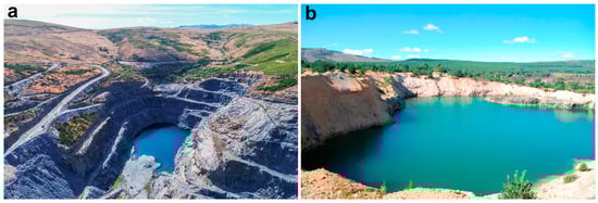
Figure 4.
(a) PI 07 in Forna (León) located at the bottom of the valley with a functional drainage channel; (b) PI 11 in Boya (Zamora), located on a slope without an outlet to the valley floor.
Various methods have been developed and several studies have been conducted to analyse how these environments should be managed to avoid compromising future uses [53,54,55,56]. In this sense, the key issues include the stability of the slopes surrounding the pit lake [53,55,57], the evolution and behaviour of rocks in open-pit mines subjected to multiple freeze–thaw cycles [58], water contamination and soil pollution in the vicinity [59,60], as well as planning for mine closure and maintaining water balance in the pit lake [61].
Integrating the pH (and other water quality data) with information on slope stability around mining pit lakes is crucial for the appropriate management of these spaces [62]. Determining potential uses, whether for anthropic purposes (cultural values), natural conservation (ecological values), or mixed uses, requires assessing soil stability, slope integrity, and water quality specific to each pit lake [63].
The extensive voids within rock formations and resulting decompressions significantly compromise slope stability in these areas. Similar to coal mining pit lakes [28], slate pit lakes often exhibit cracks along the top of their main slopes. These discontinuous deformations sometimes appear as staggered normal faults following the slope (e.g., PI 01 and PI 03 in Páramo del Sil; PI 22 in Riodolas; PI 26 in Monte Rande).
On the slopes, above quarry voids, frequent landslides occur because of massif decompressions caused by mining activities (Figure 5b, PI 26). In certain massif structures, vertical overturns affect even the escarpments of abandoned berms (e.g., PI 09, O Lambao; PI 10, Monte Rande, Figure 5a; PI 13, Flechas). In most of the pit lakes, gravitational erosion of loose materials from abandoned rocky slopes is observed.
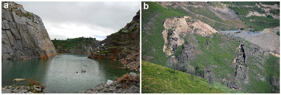
Figure 5.
(a) PI 10 in Monte Rande (Coruña) shows structural slopes that promote landslides on the left bank and overturning on the opposite bank; (b) on the right, a detailed view of a landslide and the cracks located on the northern slope of PI 26, near Pacios (Lugo).
The surroundings of slate pit lakes are characterised by extremely steep or vertical slopes resulting from mining activity and an abundance of loose material. Therefore, the closest areas are considered high-risk areas; that is, highly unstable environments prone to rockfalls of various sizes. Therefore, soil movements and slope instability are key factors to consider for future land use planning [53].
The slopes around the pit lakes are characterised by the total absence of vegetation because of their excessive steepness and lack of soil, which hinders natural stabilisation. Similarly, the shores of the pit lakes lack vegetation, except for a few isolated spots or enclaves.
Although a few of the pit lakes visited discharge water into nearby streams, most of the larger pit lakes retain water within the confines of the old quarries. For example, the three pit lakes on the Valborraz River (Orense) completely occupy the river’s talweg, with the river redirected through an artificial channel along its right bank and then its left bank. These abandoned pit lakes appear staggered and enclosed, while the river runs through a channel suspended tens of metres above the current bottom of the pit lake (Figure 6).
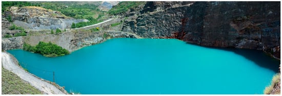
Figure 6.
The Valborraz River (Orense) is diverted to both sides of the valley via an artificial channel suspended above the three abandoned pit lakes (Figure 1c. PI 23, PI 24, and 25). In the image PI 24.
Only in certain cases did low-quality water exit the pit lakes. However, given that almost all of them exhibit signs of low water levels along their banks (and that they were observed during the dry season), it is possible that they may overflow during periods of increased flow, causing water to escape the basin. Therefore, it is essential to monitor their hydrological cycles and runoff patterns with a view to informing future use.
The slate pit lakes are generally larger than the coal pit lakes in León (Figure 7) [28]. However, they are still small in size when compared to pit lakes formed by the flooding of lignite mines, such as Puentes de García Rodríguez, which exceed 850 ha.
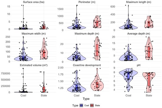
Figure 7.
Graphical representation of the variables analysed, comparing coal pit lakes and slate pit lakes.
As illustrated in Figure 7, the pH values of these pit lakes are generally above 7.5, indicating a tendency toward alkalinity rather than acidity. This trend is observed in both slate and coal pit lakes—a phenomenon previously noted in the coal mining pit lakes of León [28].
The pH value of the water, whether it trends toward acidity or alkalinity, is a crucial factor regarding the rehabilitation of post-mining landscapes [64,65]. For pit lakes created by mining, pH is a key parameter in determining whether the water is chemically inert [42,66], which might favour recreational uses, wildlife habitats (wetlands), water storage for different uses, and even aquaculture. Some treatment could be performed to the remediate acidic water in pit lakes [67], but specific uses might be appropriate for some high or low pH values. For example, some studies noted that acidic water may be helpful in dermatology [68,69], so more detailed studies and original initiatives may offer new alternative uses for some pit lakes. Also, the pH value can vary slightly throughout the year, normally reaching its maximum value in summer [70], so more exhaustive monitoring would be necessary in some cases for certain uses.
Conversely, the presence of certain minerals and compounds [29,62,71] could lead to marked acidity or alkalinity in the waters, precluding many potential uses. These conditions restrict the pit lakes to purposes such as research and teaching [21,42,72], or simply to be preserved as elements of mining heritage [25,28]. Due to the complexity of these pit lakes [73], several parameters should be analysed before approving certain uses (especially human ones) [74].
Out of the 27 pit lakes that were included in the study, 5 and 13 presented acidic and alkaline conditions, respectively. We believe this prevents their conventional use. These pit lakes might best serve as subjects for studying their conditions and evolution over the medium to long term. The remaining nine pit lakes exhibited a neutral pH of approximately 6.5–7.5, making them suitable for certain anthropic uses, such as water storage and supply, recreational activities, and natural habitats (wetlands).
However, owing to the widespread presence of extremely unstable slopes with constant rockfalls, only two pit lakes would be suitable for any use (Figure 1f, PI 12 and PI 15 in the province of Zamora). These pit lakes not only have appropriate water conditions, but also offer good access, fairly stable slopes, and perimeter protection with mesh in the most abrupt areas.
The small—and difficult to access—pit lake located to the north of Páramo del Sil (Figure 3b, PI 05) could also be considered for anthropic use because of its water quality and presence of ichthyofauna. Additionally, three pit lakes are being currently used for water supply (Figure 8b, PI 18, PI 19 and PI-20) in the communities of Riodolas and Casoio (Orense). In total, only six pit lakes (22%) out of the 27 analysed meet suitable conditions for anthropic use.
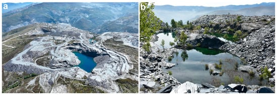
Figure 8.
(a) PI 21 with a functional drainage channel; (b) PI 18, PI 19, and PI 20 serve as the water reservoir for the towns of Riodolas and Casoio (Orense).
The detection of stability issues in the surroundings of 21 pit lakes and the conditions of alkalinity or acidity of their waters excluded most of the pit lakes from anthropic use. These pit lakes should be left as they are, with access prohibited and risks explicitly indicated. However, medium- and long-term monitoring should be conducted to track the evolution of detected issues, such as the cessation of falling of rock fragments, slope stabilisation, resettlement of landslides, vegetation colonisation in areas degraded by mining activities, and other factors that might, over time, impact water quality [75,76].
The 27 pit lakes studied exhibit a wide diversity in their primary characteristics, as illustrated in Figure 7. The imbalance between the abandoned quarries—now occupied by pit lakes—and their surrounding environment is evident. To appropriately allocate future uses for each pit lake, it is essential to understand the stability of the surrounding soils and slopes, the risk of material falling from the slopes, and the minimum water quality (pH) conditions. A proper stability design of open-pit rock slopes [77,78] and evaluation the impact of water [79] according existing guidelines should reduce the impacts in present and future mining areas, but it is too late to apply these procedures in most of the pit lakes in abandoned slate quarries in NW Spain.
5. Conclusions
The characteristics of 27 abandoned slate pit lakes in northwest Spain have been analysed, focusing on morphometric factors, slope stability, accessibility, and water properties (pH). Understanding, monitoring, and tracking their attributes is essential for identifying potential uses for these mining lakes in the medium to long term.
Due to the geographical particularities and high variability of the analysed factors, a detailed examination of each pit lake is required. Thus, most of the pit lakes are small, generally with an area less than 2.5 ha. They have an average depth of 8.6 m, and 67% of them are endorheic.
Of the 27 slate pit lakes analysed, only 12 have acceptable pH values for potential alternative use. Considering that most of the analysed pit lakes are in areas with unstable slopes and difficult access, only six of them meet criteria for both water quality and slope stability and accessibility to be suitable for alternative use.
The steep slopes surrounding these pit lakes are characterised by their instability. We believe it will take a considerable amount of time for these areas to naturally achieve adequate conditions of stability. If these spaces were initially designed to be abandoned—as they are now—then reversing these conditions later will be expensive. Therefore, allowing natural changes to occur remains the only feasible action for now. Consequently, in the short and medium terms, it will not be possible to propose anthropic uses for most of the pit lakes studied.
Finally, the water quality characteristics of these pit lakes require continuous monitoring to detect any improvements over time. Many pit lakes, especially those located on slopes, are confined, thereby preventing the emission of low-quality water. However, this endorheic condition creates an unfavourable situation for the improvement of the water properties and conditions by constraining its renewal. Further studies should be extended to other areas not yet analysed, particularly in the provinces of León and Orense. This could help determine whether the conditions observed thus far are consistent across a broader region.
Supplementary Materials
A viewer on the slate quarries pit lakes is available at: https://amelon00.shinyapps.io/Slate_pit_lakes_2024/ (accessed on 1 July 2024).
Author Contributions
J.M.R.-V.: conceptualization, methodology, investigation, field work, writing—original draft preparation; J.S.-G.: field work, validation, formal analysis, investigation, review and editing, supervision, project administration, funding acquisition; A.M.-N.: methodology, software, data curation, statics, website; A.G.-V.: methodology, review and editing, supervision, project administration; S.A.P.-P.: UAV images, field work, cartography, data curation, review and editing; R.B.G.-G.: field work, formal analysis, cartography, review and editing. All authors have read and agreed to the published version of the manuscript.
Funding
This research was funded by the Universidad de León, grant number Ref. 2022/00232/001, entitled “Environmental features, potential for use and geomorphological dynamics in pit lakes in northwestern Spain”. Adrián Melón-Nava was supported by the FPU programme of the Spanish Ministerio de Universidades (FPU20/01220).
Data Availability Statement
The original contributions presented in the study are included in the article/Supplementary Materials, further inquiries can be directed to the corresponding author/s.
Conflicts of Interest
The authors declare no conflicts of interest.
References
- Mossa, J.; James, L.A. 13.6 Impacts of Mining on Geomorphic Systems. Treatise Geomorphol. 2013, 13, 74–95. [Google Scholar] [CrossRef]
- Townsend, P.A.; Helmers, D.P.; Kingdon, C.C.; McNeil, B.E.; Beurs, K.M.; Eshleman, K.N. Changes in the extent of surface mining and reclamation in the Central Appalachians detected using a 1976–2006 Landsat time series. Remote Sens. Environ. 2009, 113, 62–72. [Google Scholar] [CrossRef]
- Tarolli, P.; Sofia, G. Human topographic signatures and derived geomorphic processes across landscapes. Geomorphology 2016, 255, 140–161. [Google Scholar] [CrossRef]
- Reece, E. Lost Mountain. A Year in the Vanishing Wilderness Radical Strip Mining and the Devastation of Appalachia; Riverhead Books: New York, NY, USA, 2006. [Google Scholar]
- Bernhardt, E.S.; Palmer, M.A. The environmental costs of mountaintop mining valley fill operations for aquatic ecosystems of the Central Appalachians. Ann. N. Y. Acad. Sci. 2011, 1223, 39–57. [Google Scholar] [CrossRef] [PubMed]
- Palmer, M.A.; Bernhardt, E.S.; Schlesinger, W.H.; Eshleman, K.N.; Foufoula-Georgiou, E.; Hendryx, M.S.; Lemly, A.D.; Likens, G.E.; Loucks, O.L.; Power, M.E.; et al. Mountaintop mining consequences. Science 2010, 327, 148–149. [Google Scholar] [CrossRef]
- Wickham, J.; Bohall Wood, P.; Nicholson, M.C.; Jenkins, W.; Druckenbrod, D.; Suter, G.W.; Strager, M.P.; Mazzarella, C.; Galloway, W.; Amos, J. The overlooked terrestrial impacts of mountaintop mining. BioScience 2013, 63, 335–348. [Google Scholar] [CrossRef]
- Edwards, J.A.; Llurdés I Coit, J.C. Mines and quarries: Industrial heritage tourism. Ann. Tour. Res. 1996, 23, 341–363. [Google Scholar] [CrossRef]
- García-Sánchez, L.; Canet, C.; Cruz-Pérez, M.Á.; Morelos-Rodríguez, L.; Salgado-Martínez, E.; Corona-Chávez, P. A comparison between local sustainable development strategies based on the geoheritage of two post-mining areas of Central Mexico. Int. J. Geoherit. Parks 2021, 9, 391–404. [Google Scholar] [CrossRef]
- Gioncada, A.; Pitzalis, E.; Cioni, R.; Fulignati, P.; Lezzerini, M.; Mundula, F.; Funedda, A. The volcanic and mining geoheritage of San Pietro Island (Sulcis, Sardinia, Italy): The potential for geosite valorization. Geoheritage 2019, 11, 1567–1581. [Google Scholar] [CrossRef]
- Prosser, C.D. Geoconservation, Quarrying and Mining: Opportunities and Challenges Illustrated through Working in Partnership with the Mineral Extraction Industry in England. Geoheritage 2018, 10, 259–270. [Google Scholar] [CrossRef]
- Ruban, D.A.; Sallam, E.S.; Khater, T.M.; Ermolaev, V.A. Golden Triangle Geosites: Preliminary Geoheritage Assessment in a Geologically Rich Area of Eastern Egypt. Geoheritage 2021, 13, 54. [Google Scholar] [CrossRef]
- Vlachopoulos, N.; Voudouris, P. Preservation of the geoheritage and mining heritage of Serifos Island, Greece: Geotourism perspectives in a potential new global UNESCO geopark. Geosciences 2022, 12, 127. [Google Scholar] [CrossRef]
- Damas Mollá, L.; Aranburu, A.; García-Garmilla, F.; Uriarte, J.A.; Zabaleta, A.; Bodego, A.; Sagarna, M.; Antigüedad, I. Cantera Gorria and Red Ereño: Natural and Cultural Geoheritage (Basque Country, Spain). Geoheritage 2022, 14, 76. [Google Scholar] [CrossRef]
- López-García, J.A.; Oyarzun, R.; López Andrés, S.; Manteca Martínez, J. Scientific, educational, and environmental considerations regarding mine sites and geoheritage: A perspective from SE Spain. Geoheritage 2011, 3, 267–275. [Google Scholar] [CrossRef]
- Mazadiego, L.F.; Llamas, B.; de Górgolas, C.R.; Pous, J.; Puche, O. The Contingent Valuation Method Applied to the Mining Heritage of Extremadura (Spain). Geoheritage 2019, 11, 665–679. [Google Scholar] [CrossRef]
- Redondo Vega, J.M. Las Minas de Carbón a Cielo Abierto en la Provincia de León. Transformación del Medio y Explotación de Recursos no Renovables; Universidad de León, Secretariado de Publicaciones: León, Spain, 1988. [Google Scholar]
- Lund, M.A.; Blanchette, M.L. Closing pit lakes as aquatic ecosystems: Risk, reality, and future uses. Wires Water 2023, 10, e1648. [Google Scholar] [CrossRef]
- Hildmann, E.; Wünsche, M. Lignite mining and its after-effects on the Central German landscape. Water Air Soil Pollut. 1996, 91, 79–87. [Google Scholar] [CrossRef]
- Castro, J.M.; Moore, J.N. Pit lakes: Their characteristics and the potential for their remediation. Environ. Geol. 2000, 39, 1254–1260. [Google Scholar] [CrossRef]
- Gammons, C.H.; Harris, L.N.; Castro, J.M.; Cott, P.; Hanna, B.W. Creating lakes from open pit mines: Processes and considerations, with emphasis on northern environments. Can. Tech. Rep. Fish. Aquat. Sci. 2009, 2826, 1–117. [Google Scholar]
- Hangen-Brodersen, C.; Strempel, P.; Grünewald, U. Characteristics of catchments disturbed by lignite mining—Case study of Schlabendorf/Seese (Germany). Ecol. Eng. 2005, 24, 37–48. [Google Scholar] [CrossRef]
- Baeten, J.; Langston, N.; Lafreniere, D. A spatial evaluation of historic iron mining impacts on current impaired waters in Lake Superior’s Mesabi Range. Ambio 2018, 47, 231–244. [Google Scholar] [CrossRef]
- Nixdorf, B.; Lessmann, D.; Deneke, R. Mining lakes in a disturbed landscape: Application of the EC Water Framework Directive and future management strategies. Ecol. Eng. 2005, 24, 67–73. [Google Scholar] [CrossRef]
- Redondo-Vega, J.M.; González-Gutiérrez, R.B.; Melón-Nava, A.; Peña Pérez, S.A.; Santos-González, J.; Gómez-Villar, A. Cambios antiguos en el paisaje de origen minero en León (España): Localización y caracteres morfométricos de las lagunas auríferas romanas. In Proceedings of the VIII Congreso Internacional La Plata en Iberoamérica, León, Spain, 13–17 September 2021. [Google Scholar]
- Redondo-Vega, J.M.; Gómez-Villar, A.; Santos-González, J.; González-Gutiérrez, R.B.; Álvarez-Martínez, J. Changes in land use due to mining in the north-western mountains of Spain during the previous 50 years. Catena 2017, 149, 844–856. [Google Scholar] [CrossRef]
- Redondo-Vega, J.M.; Gómez-Villar, A.; González-Gutiérrez, R.B.; Santos-González, J. El origen de las lagunas de León. In Xeomorfoloxía e Paisaxes Xeográficas. Catro Décadas de Investigación e Ensino. Homenaxe a Augusto Pérez Alberti; Chao, R.B., Rodríguez, F.C., Casais, M.C., García, J.H., Díaz, M.V., Eds.; Universidade de Santiago de Compostela: Santiago de Compostela, Spain, 2018; pp. 469–486. [Google Scholar]
- Redondo-Vega, J.M.; Melón-Nava, A.; Peña-Pérez, S.A.; Santos-González, J.; Gómez-Villar, A.; González-Gutiérrez, R.B. Coal pit lakes in abandoned mining areas in León (NW Spain): Characteristics and geoecological significance. Environ. Earth Sci. 2021, 80, 792. [Google Scholar] [CrossRef]
- Zhao, L.Y.L.; McCullough, C.D.; Lund, M.A.; Management, M. Mine Voids Management Strategy (I): Pit Lake Resources of the Collie Basin. Mine Water and Environment Research/Centre for Ecosystem Management. 2009. Available online: https://www.water.wa.gov.au/data/assets/pdf_file/0012/5601/96275.pdf (accessed on 1 July 2024).
- Cárdenes, V.; Ponce de León, M.; Rodríguez, X.A.; Rubio-Ordóñez, A. Roofing Slate Industry in Spain: History, Geology, and Geoheritage. Geoheritage 2019, 11, 19–34. [Google Scholar] [CrossRef]
- Cárdenes, V.; Rubio, A.; Ruiz de Argandoña, V.G. Roofing slate from Bernardos, Spain: A potential candidate for global heritage stone. Episodes 2021, 44, 3–9. [Google Scholar] [CrossRef]
- Lindoso Tato, E. La industria de la pizarra española en perspectiva histórica. Investig. Hist. Económica 2019, 11, 52–61. [Google Scholar] [CrossRef]
- García de Celis, A.; González Fernández, A.M.; Redondo Vega, J.M. La explotación de pizarras ornamentales en Castilla y León. Ería 1993, 32, 251–264. [Google Scholar] [CrossRef]
- Ferrero Arias, A.; Baltuille Martín, J.M. (Eds.) Mapa de Minerales y Rocas Industriales de Galicia. Escala 1:250000; IGME-Xunta de Galicia: Galicia, Spain, 2008; Available online: https://info.igme.es/SidPDF/166000/585/166585_0000001.pdf (accessed on 1 July 2024).
- San Román Rodriguez, J.M. Valdeorras. La Industria de la Pizarra y las Transformaciones Espaciales. Municipios de O Barco, Carballeda y Rubiá (1950–1998); Cuaderno Monográfico; Instituto de Estudios Valdeorreses: Galicia, Spain, 2000; Volume 32. [Google Scholar]
- González Nicieza, C.; Taboada Castro, J.; Menéndez Díaz, A.; Álvarez Vigil, A.E. Geological risks in slag heaps of roofing slate in Spain. Int. J. Surf. Min. Reclam. Environ. 2007, 11, 145–150. [Google Scholar] [CrossRef]
- Pérez-Alberti, A. El patrimonio glaciar y periglaciar del Geoparque Mundial UNESCO Montañas do Courel (Galicia). Cuaternario Y Geomorfol. 2021, 35, 79–98. [Google Scholar] [CrossRef]
- Santos González, J.; Redondo Vega, J.M.; González Gutiérrez, R.; Gómez Villar, A. New data about The La Baña lake origin (Cabrera Range, NW Spain) using geomorphological and sedimentological analysis. Boletín Asoc. Geógrafos Españoles 2015. [Google Scholar] [CrossRef]
- Gwyn, D. ‘The Slate Landscape of Northwest Wales’—A New Industrial World Heritage Site. Ind. Archaeol. Rev. 2023, 45, 19–31. [Google Scholar] [CrossRef]
- Price, W.R. Quarrying for World Heritage Designation: Slate Tourism in North Wales. Geoheritage 2019, 11, 1839–1854. [Google Scholar] [CrossRef]
- Goemaere, E.; Demarque, S.; Dreesen, R.; Declercq, P.Y. The Geological and Cultural Heritage of the Caledonian Stavelot-Venn Massif, Belgium. Geoheritage 2016, 8, 211–233. [Google Scholar] [CrossRef]
- McCullough, C.; Schultze, M.; Vandenberg, J. Realizing beneficial and uses from abandoned pit lakes. Minerals 2020, 10, 133. [Google Scholar] [CrossRef]
- Dwiyanto, M.R.; Damayanti, A.; Indra, T.L.; Dimyati, M. Land use changes due to mining activities in Penajam Paser Utara Regency, East Kalimantan Province. IOP Conf. Ser. Earth Environ. Sci. 2021, 1811, 012088. [Google Scholar] [CrossRef]
- Yu, L.; Xu, Y.; Xue, Y.; Li, X.; Cheng, Y.; Liu, X.; Porwal, A.; Holden, E.J.; Yang, J.; Gong, P. Monitoring surface mining belts using multiple remote sensing datasets: A global perspective. Ore Geol. Rev. 2018, 101, 675–687. [Google Scholar] [CrossRef]
- Werner, T.T.; Bebbington, A.; Gregory, G. Assessing impacts of mining: Recent contributions from GIS and remote sensing. Extr. Ind. Soc. 2019, 6, 993–1010. [Google Scholar] [CrossRef]
- Hakanson, L. A Manual of Lake Morphometry; Springer: Berlin/Heidelberg, Germany, 1981. [Google Scholar] [CrossRef]
- Del Castillo Jurado, M. Morfometría de Lagos. Aplicación a los Lagos del Pirineo. Ph.D. Thesis, Universitat de Barcelona, Barcelona, Spain, 2003. Available online: https://www.tesisenred.net/handle/10803/1428 (accessed on 1 July 2024).
- Vega, J.C.; De Hoyos, C.; Aldasoro, J.J.; De Miguel, J.; Fraile, H. Nuevos datos morfométricos para el Lago de Sanabria. Limnetica 2005, 24, 115–125. [Google Scholar] [CrossRef]
- Mijares Coto, M.J. Procedimiento de Actuación para la Aplicación de la Directiva Marco del Agua a los Lagos Artificiales Creados por la Rehabilitación de las Explotaciones Mineras a Cielo Abierto. Ph.D. Thesis, Universidade da Coruña, Corunha, Spain, 2013. Available online: http://hdl.handle.net/2183/11702 (accessed on 22 April 2023).
- Fuentes-Pérez, J.F.; Navarro Hevia, J.; Ruiz Legazpi, J.; García-Vega, A. Inventario y caracterización morfológica de lagos y lagunas de alta montaña en las provincias de Palencia y León (España). Pirineos 2015, 170, E013. [Google Scholar] [CrossRef]
- Contreras, F.I.; Paira, A.R. Comparación morfométrica entre lagunas de la planicie aluvial del río Paraná Medio y La Lomada Norte (Corrientes, Argentina). Cuad. Geogr. Rev. Colomb. Geogr. 2015, 24, 61–71. [Google Scholar] [CrossRef]
- Kalff, J. Limnology. Inland Water Ecosystems; Prentice Hall: Upper Saddle River, NJ, USA, 2002; Available online: https://livresbioapp.files.wordpress.com/2016/03/limnology-kalff.pdf (accessed on 1 July 2024).
- Al Heib, M.; Varouchakis, E.A.; Galetakis, M.; Renaud, V.; Burda, J. A framework for assessing hazards related to pit lakes: Application on European case studies. Environ. Earth Sci. 2023, 82, 365. [Google Scholar] [CrossRef]
- Kubalíková, L. Risk assessment on dynamic geomorphosites: A case study of selected abandoned pits in South-Moravian Region (Czech Republic). Geomorphology 2024, 458, 109249. [Google Scholar] [CrossRef]
- Renaud, V.; Al Heib, M.; Burda, J. 3D large-scale numerical model of open-pit lake slope stability-case study of Lake Most. Bull. Eng. Geol. Environ. 2022, 81, 282. [Google Scholar] [CrossRef]
- Wang, S.; Zhuang, Y.; Cao, Y.; Yang, K. Ecosystem Service Assessment and Sensitivity Analysis of a Typical Mine-Agriculture-Urban Compound Area in North Shanxi, China. Land 2022, 11, 1378. [Google Scholar] [CrossRef]
- Steiakakis, E.; Syllignakis, G.; Galetakis, M.; Vavadakis, D.; Renaud, V.; Al Heib, M.; Burda, J. Pit Lake Slope Stability under Water Level Variations. Geosciences 2024, 14, 142. [Google Scholar] [CrossRef]
- Yang, G.; Chen, Y.; Xie, Q.; Wu, P.; Zhang, Y. Physical and mechanical characteristics deterioration and crack evolution of sandy mudstone in an open-pit mine under multiple freeze-thaw cycles. Geomech. Geophys. Geo-Energy Geo-Resour. 2024, 10, 87. [Google Scholar] [CrossRef]
- Dziuba, E.; Buzmakov, S.; Khotyanovskaya, Y. Study of geochemical features of soils on the territory of an abandoned coal mining area using geoinformation technologies. Environ. Geochem. Health 2023, 45, 9135–9155. [Google Scholar] [CrossRef] [PubMed]
- Suhernomo, S.; Luthfi Fatah, L.; Saidy, A.R.; Priatmadi, B.J.; Noor, I.; Triwibowo, D. Strategies of water flow treatment of Paringin Pit Lake to meet wastewater discharge compliance. J. Degrad. Min. Lands Manag. 2023, 10, 4683–4695. [Google Scholar] [CrossRef]
- Soni, A.K.; Mishra, B.; Singh, S. Pit lakes as an end use of mining: A review. J. Min. Environ. 2014, 5, 99–111. [Google Scholar] [CrossRef]
- Eary, L.E. Geochemical and equilibrium trends in mine pit lakes. Appl. Geochem. 1999, 14, 963–987. [Google Scholar] [CrossRef]
- Gulpinar Sebkan, D.U.; Acar, C. Determining usages in post-mining sites according to landscape design approaches. Land Degrad. Dev. 2021, 32, 2661–2676. [Google Scholar] [CrossRef]
- Ayala Carcedo, F.J.; Vadillo Fernández, L. Manual de Restauración de Terrenos y Evaluación de Impactos Ambientales en Minería; Instituto Tecnológico Geominero de España: Madrid, Spain, 1989. [Google Scholar]
- Uhlmann, W.; Büttcher, H.; Totsche, O.; Steinberg, C.E.W. Buffering of Acidic Mine Lakes: The Relevance of Surface Exchange and Solid-Bound Sulphate. Mine Water Environ. 2004, 23, 20–27. [Google Scholar] [CrossRef]
- Gupta, S.; Palit, D.; Kar, D.; Mukherjee, A. Pitlakes of Raniganj Coal Field, W.B, India. Inventory and Water Quality Status; Natural Science, Technical Report; GRIN: München, Germany, 2019. [Google Scholar]
- Geller, W.; Schultze, M. Remediation and Management of Acidified Pit Lakes and Outflowing Waters. In Acidic Pit Lakes. Environmental Science and Engineering; Geller, W., Schultze, M., Kleinmann, R., Wolkersdorfer, C., Eds.; Springer: Berlin, Heidelberg, 2013. [Google Scholar] [CrossRef]
- Lee, N.R.; Lee, H.J.; Yoon, N.Y.; Kim, D.; Jung, M.; Choi, E.H. Acidic Water Bathing Could Be a Safe and Effective Therapeutic Modality for Severe and Refractory Atopic Dermatitis. Ann. Dermatol. 2016, 28, 126–129. [Google Scholar] [CrossRef]
- Matz, H.; Orion, E.; Wolf, R. Balneotherapy in dermatology. Dermatol. Ther. 2003, 16, 132–140. [Google Scholar] [CrossRef]
- Savage, K.S.; Ashley, R.P.; Bird, D.K. Geochemical Evolution of a High Arsenic, Alkaline Pit-Lake in the Mother Lode Gold District, California. Econ. Geol. 2009, 104, 1171–1211. [Google Scholar] [CrossRef]
- Kumar, R.N.; McCullough, C.D.; Lund, M.A. Water resources in Australian mine pit lakes. Min. Technol. Trans. Inst. Min. Metall. Sect. A 2009, 118, 205–211. [Google Scholar] [CrossRef]
- McCullough, C.; Lund, M.A. Opportunities for sustainable mining Pit Lakes in Australia. Mine Water Environ. 2006, 25, 220–226. [Google Scholar] [CrossRef]
- Geller, W.; Schultze, M.; Kleinmann, R.; Wolkersdorfer, C. (Eds.) Acidic Pit Lakes. In Environmental Science and Engineering; Springer: Berlin/Heidelberg, Germany, 2013. [Google Scholar] [CrossRef]
- Mantero, J.; Thomas, R.; Holm, E.; Rääf, C.; Vioque, I.; Ruiz-Canovas, C.; García-Tenorio, R.; Forssell-Aronsson, E.; Isaksson, M. Pit lakes from Southern Sweden: Natural radioactivity and elementary characterization. Sci. Rep. 2020, 10, 13712. [Google Scholar] [CrossRef]
- Varnell, C. Utilization of Abandoned Coal Mines as Sources of Municipal Water. Acad. Lett. 2021, 19, 251–258. [Google Scholar] [CrossRef]
- Varnell, C.J.; Van Brahana, J.; Steele, K. The Influence of Coal Quality Variation on Utilization of Water from Abandoned Coal Mines as a Municipal Water Source. Mine Water Environ. 2004, 23, 204–208. [Google Scholar] [CrossRef]
- Read, J.; Stacey, P. Guidelines for Open Pit Slope Design; CSIRO-CRC: Collingwood, VIC, Australia, 2009; 490p. [Google Scholar] [CrossRef]
- Abdulai, M.; Sharifzadeh, M. Probability Methods for Stability Design of Open Pit Rock Slopes: An Overview. Geosciences 2021, 11, 319. [Google Scholar] [CrossRef]
- Beale, G.; Read, J. Guidelines for Evaluating Water in Pit Slope Stability; CSIRO-CRC: Collingwood, VIC, Australia, 2013; 599p. [Google Scholar]


Disclaimer/Publisher’s Note: The statements, opinions and data contained in all publications are solely those of the individual author(s) and contributor(s) and not of MDPI and/or the editor(s). MDPI and/or the editor(s) disclaim responsibility for any injury to people or property resulting from any ideas, methods, instructions or products referred to in the content. |
© 2024 by the authors. Licensee MDPI, Basel, Switzerland. This article is an open access article distributed under the terms and conditions of the Creative Commons Attribution (CC BY) license (https://creativecommons.org/licenses/by/4.0/).