Article

Climate-Driven Dynamics of Runoff in the Dayekou Basin: A Comprehensive Analysis of Temperature, Precipitation, and Anthropogenic Influences over a 25-Year Period

1
Gansu Qilian Mountain Water Conservation Forest Research Institute, Zhangye 734000, China
2
Qilian Mountain Eco-Environment Research Center of Gansu Province, Lanzhou 730000, China
3
Gansu Qilian Mountain Forest Ecosystem of the State Research Station, Zhangye 734000, China
4
Department of Environmental Sciences, University of Arizona, Tucson, AZ 85721, USA
*
Author to whom correspondence should be addressed.
Water 2024, 16(7), 919; https://doi.org/10.3390/w16070919
Submission received: 2 March 2024 / Revised: 18 March 2024 / Accepted: 20 March 2024 / Published: 22 March 2024
(This article belongs to the Special Issue Research on Watershed Ecology, Hydrology and Climate)

Abstract

:
Understanding runoff dynamics is vital for effective water management in climate-affected areas. This study focuses on the Dayekou basin in China’s Qilian Mountains, known for their high climate variability. Using 25 years of data (1994–2018) on river runoff, precipitation, and temperature, statistical methods were applied to explore the annual variations and climate change impacts on these parameters. Results reveal a significant variability in the river runoff (132.27 to 225.03 mm), precipitation (340.19 to 433.29 mm), and average temperature (1.38 to 2.08 °C) over the period. Decadal rising rates average 17 mm for runoff, 17 mm for precipitation, and 0.25 °C for temperature, with the peak precipitation and runoff occurring in 1998–2000, 2008, and 2016. The annual runoff distribution also exhibited a unimodal pattern, peaking at 39.68 mm in July. The cumulative runoff during low periods constituted only 13.84% of the annual total, concentrated in the second half of the year, particularly during the June-October flood season. The correlation analysis underscored a strong relationship between river runoff and precipitation (correlation coefficient > 0.80), while the temperature correlation was weaker (correlation coefficient < 0.80). This 25-year analysis provides valuable insights into runoff variation, elucidating the interconnected effects of temperature and precipitation in the Dayekou basin, with substantial implications for sustainable development amid climate challenges.

1. Introduction

Evaluating the changes in the hydrological cycle due to climate change, as well as their impacts on ecological systems, is crucial for understanding climate-driven dynamics [IPCC, 2023] [1]. Runoff is an important part of the hydrological cycle, which is strongly affected by climate variability and human activities, and changes dramatically at different spatial and temporal scales [2,3]. Furthermore, precipitation plays a vital role in the water cycle, alongside runoff and evaporation. Together, they form the dynamic pattern of regional water distribution and the balance of water resources [4,5]. In the context of global warming, the water cycle between land and sea has also undergone tremendous changes [6,7]. Climate change includes changes in precipitation, temperature, and potential evaporation, which greatly affect the future runoff in a basin [8]. Previous studies have shown that global runoffs have increased in the 20th century [9,10]. This could be linked to the increase in average global surface temperatures. For instance, the Intergovernmental Panel on Climate Change (IPCC) reports that the global average surface temperature increased by 0.85 (0.65~1.06) °C from 1880 to 2012. Furthermore, the direct and indirect effects of human activities, such as deforestation, afforestation, reservoir operation, large-scale irrigation, and urbanization, have been recognized as significant factors contributing to regional variations in runoff patterns [11,12].
The precipitation characteristics of a basin can more intuitively reflect the original state of the atmospheric environment [13] and this could potentially significantly impact basin runoff. Over the years, scholars have analyzed and studied various factors such as river runoff characteristics, precipitation, and temperature values to assess the interannual, intergenerational, and abrupt changes in regional runoff flow over long time series. Their research has yielded relatively significant findings regarding the response of runoff to climate change [9,14]. These studies employed several methods to analyze the effects of climate variability and human intervention on runoff changes [15,16]. Although hydrological modeling is powerful, it is subject to the inherent variability and uncertainty of the impact of human activities on the hydrological system [17], and it is difficult to obtain a large amount of input data related to human activities.
The Dayekou Basin in the middle of the northern foot of the Qilian Mountains is a typical semi-closed basin recharged by precipitation and seasonal ice and snow meltwater. The runoff in the basin is very sensitive to climate change [18]. Due to the influence of climate change and human activities, the sudden decrease of runoff in the Dayekou Basin of the Qilian Mountains has attracted wide attention. As early as 1973, some scholars have carried out relevant research in the upstream basin [19]. Shang et al. [20] simulated the runoff change in the upper reaches of the Heihe River and concluded that the change in runoff was positively correlated with the change in precipitation, and the relationship with temperature change was more complicated. Others studied the runoff characteristics of three discontinuous hydrological years in the Dayekou Basin and concluded that the runoff was mainly affected by precipitation and previous precipitation [10]. Most of the above-mentioned studies on the runoff characteristics of a typical watershed in the Qilian Mountains focus on the daily variation characteristics of the runoff in one or more discontinuous hydrological years and lack a long-term scale on the interannual and interdecadal continuity of river runoff in the alpine region. Due to the short time scale, the coupling relationship between temperature and annual runoff is also not clear. Considering that the 18 km river channel upstream of the Dayekou Reservoir covers over 98% of the basin’s catchment area and that the Dayekou Basin, spanning 80 km2, experiences substantial inflow and swift water movement, the challenge arises in establishing a water weir due to the challenging conditions. Consequently, accurately monitoring real-time basin runoff becomes a difficult task in basin research. This underscores the necessity for multi-scale and multi-factor investigations into the water cycle and water conservation functions within the Qilian Mountains.
The current paper addresses this information gap by studying the snow-covered Dayekou Basin, with multi-year meteorological and hydrological data for an extended period. Based on 25 years (1994–2018) of runoff and meteorological data, the dynamic characteristics of the precipitation in the basin and its impact on runoff changes are studied to reveal the mechanism of the water cycle and climate change in the basin. The dynamic characteristics of precipitation, temperature, and runoff in the basin and their coupling relationship are of practical significance for the comprehensive management and development of water resources in the basin, the understanding of water cycle processes, and the corresponding mechanisms. These aspects are evaluated in depth in this study. The findings are, therefore, not only relevant for the Dayekou basin in the Qilian Mountains, but could also be applied to other related areas.

2. Materials and Methods

2.1. Study Area

The Dayekou Basin is in the upper reaches of the Heihe River in the middle of the northern foot of the Qilian Mountains of China (100°13′~100°16′ E, 38°16′~38°33′ E), as shown in Figure 1. It starts from Xigouliang in the west, extends to Mazongliang in the east, Pailugou in the south, and Zhengnangou in the north. It originates from the Yeniu Mountain in the Sunan Yugur Autonomous County, and is composed of six tributaries namely, Dongcha, Xicha, Toutangou, Xigoulianggou, Guantaigou, and Shengou. The basin’s area is 80 km2, which belongs to the typical continental semi-arid alpine climate. Mild metamorphic rocks, volcanic rocks, carbonates, and intermediate-acid igneous rocks are widely distributed in the high mountains where the basin is located. The soil-forming parent materials are mainly peat, conglomerate, and purple sand shale. The Dayekou Reservoir, constructed in 1980, is in the Bayi Village Horseshoe District, downstream from the basin. The dam is a masonry gravity dam and is a small reservoir, with a total capacity of 350 m3. It is a regulating reservoir mainly for irrigation and flood control, with an overall irrigation area of 1342.93 hm2. Due to the good water collection function, the dam body goes deep into the bedrock layer, and there is no leakage of water in the catchment area of the basin. The dam body itself is a measuring weir, which can accurately measure the total water inflow of the basin. The change in the reservoir water level can be used to measure the river runoff of the basin, which solves the problem of monitoring river runoff in medium-scale basins for a long period of time. This basin is characterized by different types of landcovers (See Figure S1), such as a closed forest (the most common landcover), sparse wood land, high coverage grassland and many more.
The common land use in the Dayekou Basin in the Qilian Mountains of China, as evidenced by the published literature, is primarily grassland. Multiple studies conducted over different periods have consistently identified grassland as the dominant land use type in this region [21,22]. Additionally, there is a presence of construction land, farmland, unused land, and woodland, though these cover smaller proportions compared to the grassland. Over time, water areas and grasslands have exhibited a declining trend, while increases have been observed in the unused land, construction land, and farmland. Woodland areas have seen less change compared to other land types. The drivers of these land use changes include population growth, technological advancements, urbanization, economic development levels, and policy decisions. This study focused on the impact of hydropower plants on runoff in the Dayekou Basin due to the dominance of grassland cover and the limited other anthropogenic activities, as illustrated in Figure S1. This decision aligns with the existing literature that identifies hydropower as a primary influence on hydrological dynamics within the region. The analysis, therefore, centers on the substantial modifications to the basin’s flow regime and water availability attributed to hydropower development.

2.2. Source of Water Volume and Weather Data

Three main datasets, measured from 1994 to 2018, were used in this study: precipitation, temperature, and runoff. The temperature and precipitation data were collected from the automatic weather station of the Qilian Mountain Forest Ecological Positioning Research Station located at the outlet of the basin (altitude of 2900 m). The collected data were classified and summarized according to the Forestry Industry Standard of the People’s Republic of China [23]. The forest ecosystem positioning observation index system and the forest ecosystem service function evaluation specification guided by the Standard [24] were also compiled. The runoff data was determined using the visual water gauge method based on the water volume within the Dayekou Reservoir measured daily from 8:00 to 20:00. The water storage capacity was calculated using the reservoir capacity curve table. The difference in the stored water of the basin across various time scales represents the incoming water volume in the basin during a specific period (measured in cubic meters). The river runoff of the basin during this timeframe (expressed in millimeters) is commonly referred to as the basin’s river runoff, calculated as the ratio of the incoming water volume per unit of time to the total area of the basin as described above.

2.3. Statistical Characteristics of the Runoff, Temperature, and Precipitation Series

Initial descriptive statistics were performed on the collected data and represented using metrics such as the mean, variance, coefficient of variation, and skewness coefficient. Inferential statistical analyses, such as a regression and trend analysis, were performed using the approach described below (Section 2.5 and Section 2.6):
Mean   value :   R ¯ = 1 n i = 1 n R i
Variance :   δ = 1 n i = 1 1 ( R i R ¯ ) 2
Coefficient   of   variation :   C v = δ R ¯ = 1 n i = 1 n ( Κ i 1 ) 2
where, K i = R i R ¯
Coefficient   of   skewness :   C S = i = 1 n ( K i 1 ) 3 n C n 3

2.4. Concentration Analysis

Concentration is a vector accumulation. It was determined by dividing the monthly runoff into a certain angle (360°), and then calculating the percentage of the combined amount to the annual runoff. The following formula was used:
C n = R i = 1 12 R i , R = R x 2 + R y 2 , R x = i = 1 12 R i c o s θ i , R y = i = 1 12 R i s i n θ i
The amplitude of runoff variation (ΔR) was calculated using the relative variation range Ck and the absolute variation range δR. The following formula was used:
Ck = Rmax/Rmin
δR = RmaxRmin
where Rmax is the maximum monthly runoff, and Rmin is the minimum monthly runoff.

2.5. Linear Trend Analysis of Interannual Variability

The linear tendency method is used to intuitively analyze the changing trends of the runoff, precipitation, and temperature in the time series. The slope of the linear equation was used to characterize the average trend change rate of the time series as shown in the equation:
y = a + b x
where y is the series of runoff and climate factors, x is the time series, b is the linear trend term, and 10b is the climate tendency rate of runoff and climate every 10a (°C/10a or mm/10a). The results of the linear regression calculations indicate that when the tendency of runoff and climate variables is greater than 0, it signifies an upward trend over time, while a tendency less than 0 indicates a downward trend. The magnitude of these values reflects the degree of fluctuation in the rate of climate change, indicating the extent of the rise or fall in trends.

2.6. Regression Analysis of Interannual Variation

A multiple regression analysis was used to analyze the interannual variation in temperature, precipitation, and river runoff. The regression model was established with river runoff (R) as the dependent variable, precipitation (P) and temperature (T) as independent variables (R = a + b1T + b2T). The regression model of the annual average temperature, annual precipitation, and annual river runoff was obtained via linear regression analysis, and the standard deviation was used to test and rank. A sensitivity analysis of climate-hydrology models is used to determine how changes in temperature and precipitation might influence river runoff. For a sensitivity analysis of the regression model provided (R = a + b1T + b2P), where R is the runoff, T is the temperature, and P is the precipitation, we would perturb T and P to be within realistic ranges based on climate projections. The sensitivity of R to T and P would then be determined by how much R changes in response to changes in T and P. The regression coefficients (b1 and b2) would give an initial estimate of this sensitivity, but a thorough sensitivity analysis would also consider non-linear responses and interactions between T and P.

2.7. Uncertainty Analysis in Methodological Approach

In this study, the evaluation of uncertainty is meticulously addressed through a twofold approach: quantifying statistical uncertainties and testing the robustness of our hydrological model’s assumptions. Standard statistical methods were employed to calculate 95% confidence intervals and standard errors for all principal hydrological parameters, making it possible to present a probabilistic range that encapsulates the expected variability within the observational data. To ensure the reliability of the hydrological model, a comprehensive sensitivity analysis was conducted, as described above (Section 2.6). This analysis entailed systematically altering temperature and precipitation inputs within their expected range of variability, derived from regional climate projections, to observe the consequent effects on runoff estimates. This rigorous assessment of model sensitivity serves not only to elucidate the uncertainty bounds associated with the assumptions but also to refine the understanding of the intricate water cycle dynamics specific to the Dayekou Basin.

3. Results and Discussion

3.1. Temporal Analysis of Precipitation, Runoff, and Temperature (1994–2018)

3.1.1. Interannual Variation of Runoff, Precipitation, and Temperature

Temporal variations in hydroclimatic conditions were observed in the Dayekou Basin over the 25-year period under examination. The annual river runoff, precipitation, and average temperature exhibited considerable variability, ranging from 132.27 to 225.03 mm, 340.19 to 433.29 mm, and 1.38 to 2.08 °C, respectively. The calculated annual average values of 178.65 mm for river runoff, 388.33 mm for precipitation, and 1.81 °C for temperature provide insight into the central tendencies of these climatic parameters (Supplementary Materials, Tables S1 and S2). The observed peaks in precipitation and runoff during 1998–2000, 2008, and 2016 (Figure 2) could be due to climatic influences, potentially associated with phenomena such as El Niño or La Niña [25]. The data obtained in this study, therefore, provide a context for understanding the implications of these climatic fluctuations on regional precipitation patterns. The delineated annual temperature extremes of 0.76 °C and 2.89 °C indicate a relatively constrained temperature range. Analyzing the ecological ramifications of these variations on local ecosystems, particularly in terms of their impact on flora and fauna, aligns with the broader discourse on the intersection of climate change and ecological dynamics.
Furthermore, the identified temperature change trend of 0.25 °C/10a warrants consideration in the context of global climate change. This is especially important considering the observed trend enhances our understanding of the region’s susceptibility to broader climatic shifts, with reference to the IPCC’s “Global Warming of 1.5 °C” [26]. This offers a framework for contextualizing these findings within the global climate change discourse, most especially within the Qilian mountains, which forms the northeastern escarpment of the Tibetan Plateau. The Tibetan Plateau has been reported by the IPCC to be warming up three times faster than the rest of the Earth, with an estimated two-thirds of the region’s remaining glaciers expected to vanish by the end of the century [27].
The rising demand for economic development has driven human activities to modify the utilization of water resources in the basin. Since 2000, over 20 hydropower stations have been constructed in the Zhangye section of the Qilian Mountains, as reported in the ‘Evaluation Report on the Effectiveness of Ecological Governance in Qilian Mountains’ (hereinafter referred to as the Report). These developments have resulted in varying degrees of disruption to the watershed habitat and alterations to the natural hydrological processes of the basin. The synchronous upward trend in river runoff and precipitation, coupled with the proliferation of hydropower stations since 2000, signifies a critical intersection between climatic patterns and anthropogenic interventions. The findings in this study enrich the discussion on the ecological implications of human-induced changes in the hydrological regime. An examination of the impact of hydropower station construction on the watershed habitat, considering alterations in flora and fauna, also provides additional information for evaluating the ecological consequences of anthropogenic interventions. This analysis aligns with broader discussions on the ecological repercussions of dam operations, as expounded by da Silva et al. [28]. Chen et al. [29] observed from their study in the Yantze river of China that runoff shows little response to major developments from 1955–2011.
Furthermore, these results provide significant insights into the intricate interplay between climatic variations, anthropogenic activities, and their ecological ramifications within the Dayekou Basin. However, it is important to note that within this study, the impact of anthropogenic activities was limited to information regarding the effects of water conservancy projects, such as hydropower stations. Furthermore, the trends observed and reported were only statistically significant in respect to temperature (p value ≤ 0.05).

3.1.2. Runoff Concentration and Amplitude Analysis

The observed changes in the annual runoff distribution within the Dayekou Basin provide valuable insights into the dynamic interplay of atmospheric factors, human activities, and the resulting hydrological response. By employing metrics such as the inhomogeneity coefficient, distribution complete adjustment coefficient, concentration degree, and change range, this study seeks to characterize the distribution patterns over time, shedding light on the underlying mechanisms driving these changes. The data from Table 1 reveal a compelling temporal trend in the annual distribution concentration of runoff, demonstrating a gradual downward trajectory. This finding suggests a shift in the hydrological dynamics of the basin, prompting further exploration into potential contributing factors. A plausible explanation emerges with the consideration of rising temperatures, which are known to influence ice and snow melting, consequently leading to an increased water inflow in the upper reaches of the basin. Glacial melt is a significant contributor to runoff in the Dayekou Basin, where elevated temperatures have accelerated glacial melting rates. The increased meltwater volume enhances river system inflows, particularly during warm months, aligning with observed peak runoff periods. Understanding the contribution of glacial melt to runoff is essential for deciphering seasonal flow variations and ensuring the long-term sustainability of water resources in the region, influencing both river discharge rates and the water availability for ecological systems and human consumption. This hypothesis finds support in the 2018 report issued by the Northwest Institute of Eco-environment and Resources of the Chinese Academy of Sciences. The fluctuation in the relative variation range (Ck) of the Dayekou Basin, with an average of 18.106 and peaking at 26.167 between 1999–2003, presents an additional layer of complexity to the discussion. This peak aligns with a period marked by the centralized construction of water conservancy facilities in the upper reaches of the basin. The interference with the self-regulation function of the hydrological ecosystem during this phase underscores the significant role of anthropogenic activities in shaping the runoff dynamics. However, as the study progresses through time, a discernible trend emerges—a gradual decrease in the amplitude. This diminishing trend, which was statistically significant (p value ≤ 0.05) and especially notable in the later period of 2014–2018, corresponds to the ecological environment rectification efforts in the Qilian Mountains. This phase was characterized by the demolition of water conservancy projects in the basin, resulting in the reduction in human-induced impacts, allowing the self-regulation function of the basin to gradually restore itself. Consequently, the annual distribution of the entire basin tends to become more uniform. This study’s findings align with the existing literature discussing the impact of climate change on hydrological processes [30] and the role of human activities in disrupting natural water systems [31]. Moreover, the specific contributions of increasing temperature and water conservancy projects to the observed changes resonate with the works of Chen et al. [32], Xia et al. [33], and Chang et al. [34].

3.1.3. Examination of Seasonal Patterns and Fluctuations

The annual runoff distribution in the Dayekou Basin displays a distinctive unimodal pattern, characterized by a peak from June to October, reaching its maximum value of 39.68 mm in July. Conversely, the lowest values occur in January, with a minimum of 1.55 mm, and in April, November, and December. The cumulative runoff during these low periods only accounts for 13.84% of the annual total. Consequently, the Dayekou Basin experiences a concentration of runoff in the second half of the year, particularly during the flood season from June to October.
The observed runoff pattern is closely linked to the interplay between precipitation and temperature changes throughout the year, as depicted in Figure 3. The monthly average temperature and precipitation in the Dayekou Basin exhibit a single peak type, with the highest temperatures occurring from June to August. Notably, this period aligns with the peak time of runoff, reinforcing the influence of temperature on runoff dynamics. The basin’s geographical location at the northern foot of the Qilian Mountains contributes to this correlation. Apart from precipitation, the dominant contributor to river runoff is the melting snow during the summer months. Consequently, the unique phenomenon of a single-peak runoff curve and an extended runoff period can be attributed to the interplay between precipitation and temperature, with snowmelt playing a pivotal role. This observation is consistent with the existing literature on hydrological processes in mountainous regions. For instance, studies by Yin et al. [35] emphasized the significance of temperature in governing snowmelt and subsequent river runoff. Additionally, the influence of topography and geographical features on runoff characteristics aligns with the findings of Sajikumar and Remya [36], emphasizing the importance of understanding local climate and landscape dynamics in hydrological studies. However, in contrast Chen et al., [29] observed that the annual precipitation and runoff variability in the Yangtze River was very low. For instance, soil moisture dynamics play a pivotal role in runoff generation, acting as an intermediary that modulates the infiltration and surface flow of water. Variations in soil moisture, influenced by precipitation patterns and evapotranspiration rates, can either facilitate the storage of water, mitigating immediate runoff, or contribute to runoff during periods of soil saturation. In the Dayekou Basin, the interplay between soil moisture and topographical features could have determined the proportion of precipitation that became surface runoff, with potential implications for flood frequency and water availability in downstream ecosystems and human settlements.

3.1.4. Temporal Dynamics of Seasonal Runoff Variations

This study investigates the temporal dynamics of seasonal runoff variations and their respective contributions to the overall variability in total runoff within the specified study area. The presented results, summarized in Table 2, depict the percentage distribution of seasonal runoff variations (in spring, summer, autumn, and winter) for five distinct time intervals spanning from 1994 to 2018. A five-year interval was chosen for the data presentation and analysis to provide a standard time period to be compared over the entire 25 years and also balance the detailed temporal resolution with the long-term climate variability, facilitating a robust analysis of decadal trends and patterns in the hydroclimatic data. The mean values across the study period provide a comprehensive overview of the average contribution of each season to the total runoff variation. Notably, the summer season exhibits the highest mean percentage (53.36%), emphasizing its substantial role in influencing overall runoff patterns. In contrast, winter demonstrates the lowest mean percentage (3.01%), indicating a comparatively minor impact on the total runoff variation. These variations were determined to be statistically significant (p value ≤ 0.05), which indicates the influence of external factors.
The dominance of the summer season in contributing to total runoff, as evidenced by its consistently high mean percentage (53.36%), aligns with previous studies emphasizing the significance of summer precipitation and snowmelt in shaping hydrological patterns [37,38]. The observed variations underscore the importance of considering seasonal dynamics in water resource management strategies, particularly during periods of increased water demand. The observed significant increase in runoff in the winter of 1999–2003 (Table 2) can be attributed to several factors, but mainly could be due to the warmer winter in that time period.
The temporal variations in the contributions of different seasons may indicate broader climate-related shifts in precipitation patterns. Previous research has highlighted the potential influence of climate change on seasonal hydrological cycles, with alterations in precipitation regimes impacting runoff dynamics [39]. The observed increases in summer and autumn contributions alongside decreases in winter contributions merit further investigation into the potential climatic drivers behind these trends. The identified patterns in seasonal runoff variations have implications for the local ecosystem. Studies have demonstrated that alterations in runoff patterns can influence aquatic habitats, affecting species’ composition and biodiversity [40]. Understanding the specific impacts of each season on the aquatic ecosystem is crucial for informed conservation and management strategies.
These findings contribute valuable insights into the temporal dynamics of seasonal runoff variations, facilitating a better understanding of the hydrological regime within the study area. Furthermore, the results presented in this table lay the groundwork for further research aimed at assessing the implications of seasonal variations on water resource management and ecosystem sustainability.

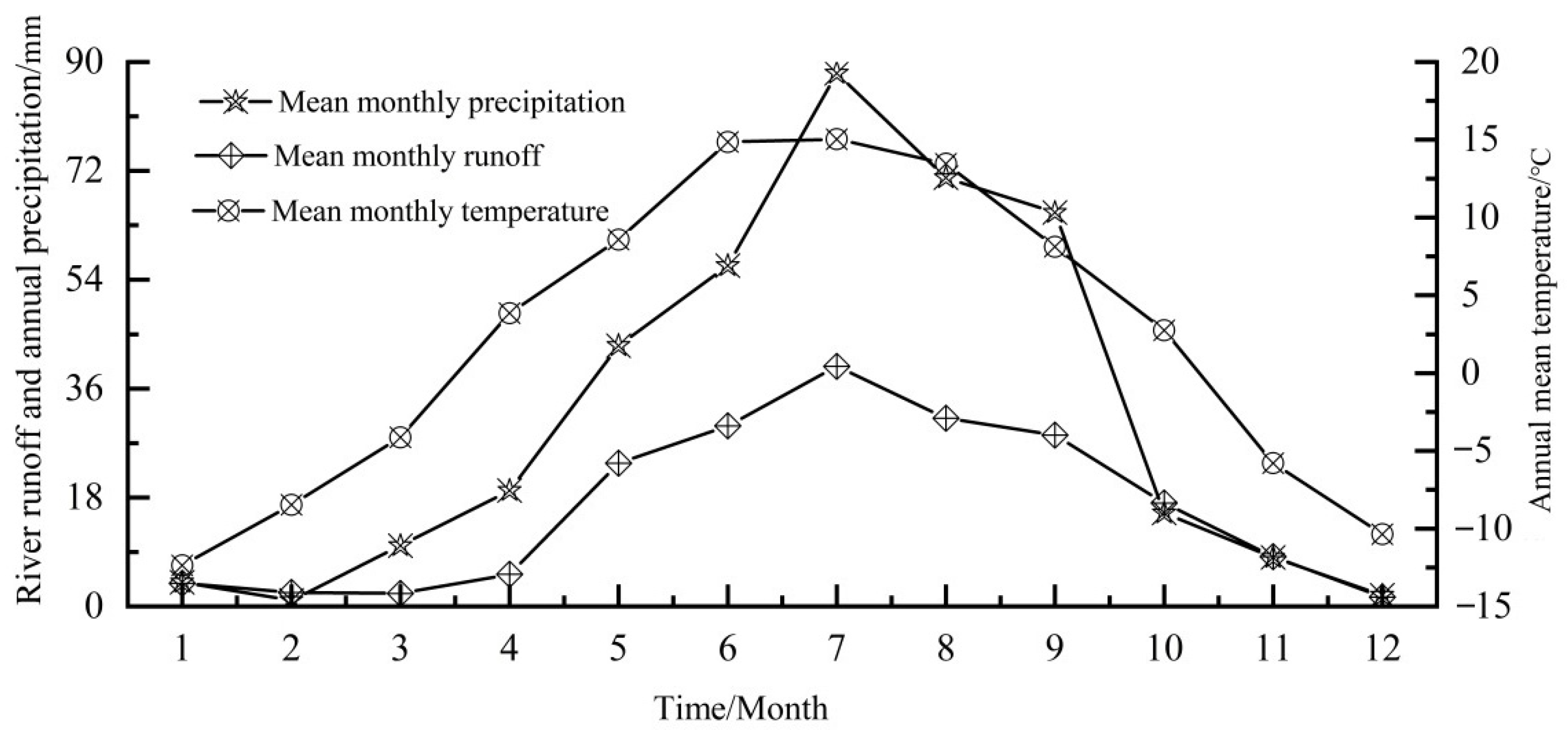
3.2. Coupling Relationship among Runoff, Precipitation, and Temperature

The comprehensive analysis of river runoff, precipitation, and temperature in the Dayekou Basin over the past 25 years elucidates an interplay between these environmental factors. The correlation results, as depicted in Table 3, underscore a significant relationship between river runoff and precipitation (correlation coefficient > 0.80), while the correlation with temperature is comparatively weaker (correlation coefficient < 0.80). This finding accentuates the multifaceted nature of runoff dynamics, influenced by both atmospheric precipitation and temperature. The pronounced correlation with precipitation is particularly notable, affirming its predominant role in shaping the runoff patterns within the alpine Dayekou Basin.
The alpine characteristics of the Dayekou Basin, situated in the ice and snow basin of the Qilian Mountains, introduce unique hydrological dynamics. In addition to direct atmospheric precipitation, river recharge includes a substantial contribution from the ice and snow meltwater originating upstream. This complexity underscores the importance of considering both atmospheric precipitation and the influence of temperature variation on the basin’s upstream water source. The relevance of this approach is supported by similar studies in the Kuitun River Basin, where a significant correlation between runoff and precipitation was observed, aligning with the findings of the present study [41]. In contrast, Shang et al. [20] reported that the relationship of runoff with the change in temperature is more complicated. However, the influence of precipitation change is stronger. This was found in studies of the Heihe River Basin, which originates from the Qilian Mountain region (the same area as the present study).
In alpine regions, a rise in temperature emerges as a pivotal factor inducing changes in regional runoff. The literature, such as the work by Allan et al. [39] and Abbas et al. [42], attests to the significance of temperature in influencing glacier meltwater discharge, further emphasizing its role in driving variations in runoff dynamics.
The quantitative verification of the correlation coefficients through the analysis of residuals (Figure 4 and Figure 5) adds robustness to the study. The small absolute values and variation ranges of residuals for precipitation and temperature affirm the high degree of fit between the regression line and the linear data. This suggests a strong correspondence between the observed factors and the model, substantiating the accuracy of the correlation. Moreover, the statistical results, demonstrating that nearly 65% of annual river runoff, annual average temperature, and annual precipitation fall within specific ranges, offer additional validation.
The consideration of the coefficient of variation underscores the relative magnitudes of variations within the studied variables. Notably, runoff exhibits the largest variation, followed by annual precipitation, with the average annual temperature showing the least variability. This insight into the probability of climate extreme events in the Dayekou Basin over the past 25 years indicates a relatively low likelihood. The discussion above emphasizes the predominant role of atmospheric precipitation in controlling the runoff dynamics of the Dayekou Basin. The general consistency in the evolutional trend of runoff with precipitation and temperature is attributed to the indirect influence of temperature on runoff through processes like evaporation and snowmelt. Consequently, precipitation emerges as a direct influencing factor, while temperature serves as an indirect influencer, both impacting the basin’s runoff output in distinct ways.

3.3. Annual Regression Analysis of River Runoff, Precipitation, and Temperature

There was a significant regression relationship between river runoff, precipitation, and temperature in the Dayekou Basin (see Supplementary Material Table S3). The regression equation of the basin can be fitted accordingly using the 25-year data, which is completed through Formula (9):
r = 27.02 t + 0.61 p 28.52   ( R 2 = 0.701 )
In the formula, r, p and t represent the annual river runoff, annual precipitation, and annual average temperature, respectively. In the statistical table of the F test (Table S4), the test value of F at this time is 21.32, far greater than F0.05 (2,15) = 3.68. The re-examination t test (Table S5) demonstrates the regression coefficient a = −25.82, b = 27.02, the test coefficient T1 = 3.47 and T2 = 5.41, with both being greater than T0.05/2 (15) = 2.182.
As highlighted in the literature, the increasing trend of global warming and increasing human activities have prompted a shift in the approach to understanding land water resource utilization and the water cycle. Notably, alpine regions such as the Dayekou Basin, characterized by snow and ice, present unique challenges in predicting runoff variations due to their diverse, random, and nonlinear nature [43].
To capture the temporal dynamics of river runoff, precipitation, and temperature, a monthly data model is formulated, treating the month as the independent variable and river runoff, precipitation, and temperature as dependent variables (Table 4). The derived function equations facilitate the simulation of monthly variations, allowing for a comparison between the actual monitored values in 2018 (Supplementary Table S6). The results, presented in Table 5, show distinct simulation value variations among the variables. For instance, the largest variations occured in January, September, and April, while the smallest variations occured in August and December, respectively. These variations underscore the temporal heterogeneity in the response of river runoff, precipitation, and temperature to monthly fluctuations.
The approach employed in this study aligns with previous studies that emphasize the importance of monthly or seasonal analyses in understanding hydroclimatic variations. For instance, Arab and Mesgari [44] demonstrated the significance of monthly modeling in capturing the nuances of precipitation variability, highlighting its implications for water resource management. Additionally, the observed temporal heterogeneity echoes the findings of Dong et al. [45], who emphasized the importance of considering season-specific responses in hydrological modeling.
Considering an average annual temperature of 1.62 °C and an annual precipitation of 374.06 mm, our model predicted an annual river runoff in the basin of 165.47 mm, closely aligning with the monitored value (Figure 6). This alignment not only reinforces the reliability of the model but also contributes valuable insights into the interconnections between temperature, precipitation, and river runoff. The findings of this study align with the broader literature on hydroclimatic modeling, supporting the notion that considering monthly dynamics is crucial for accurate simulations and predictions in water resource studies. The sensitivity analysis revealed that temperature has a noticeable impact on runoff. Specifically, a 1 °C increase in temperature is associated with a decrease in runoff by 30 mm, indicating a sensitivity coefficient of −0.3 mm/°C (Figure 6b). Conversely, a decrease in temperature by 1 °C would result in an increase in runoff by the same magnitude. This negative sensitivity to temperature suggests that rising temperatures, possibly due to climate change, could reduce river runoff levels, potentially through mechanisms such as increased evapotranspiration and reduced snowpack contributions.
Precipitation demonstrated a more pronounced effect on runoff compared to temperature. The analysis showed that a 10% increase in precipitation would lead to a 120 mm increase in runoff, while a 10% decrease would result in a 120 mm decrease (Figure 6a). This implies a high sensitivity of runoff to precipitation, with a coefficient of +0.12 mm/mm of precipitation change. The direct proportionality between precipitation and runoff underscores the significance of precipitation as a driver of runoff variability in the basin.
The findings from this analysis underscore the greater sensitivity of the modeled runoff to precipitation changes over temperature fluctuations. This suggests that in the context of the basin, variations in precipitation are a more critical factor affecting runoff volumes than temperature changes.

4. Conclusions

In light of global warming and the ongoing ecological restoration and management efforts in the Qilian Mountains, an analysis was conducted on the river runoff, temperature, and precipitation data of the Dayekou Basin from 1994 to 2018. Employing basic statistical methods, a regression analysis, and a correlation analysis, we examined the basin’s runoff characteristics, including interannual variations and trends. Over the 25-year period, the annual river runoff, precipitation, and average temperature fluctuated within the ranges of 132.27–225.03 mm, 340.19–433.29 mm, and 1.38–2.08 °C, respectively. Roughly 65% of the years experienced fluctuations within these ranges. Temperature exhibited the greatest interannual variation, followed by river runoff, with precipitation showing the smallest variation. The distribution of annual runoff series in the Dayekou Basin aligns with typical ice and snow basin characteristics.
During the past 25 years, the river runoff, atmospheric precipitation, and temperature in the Dayekou Basin showed a fluctuating upward trend. The temperature change tendency rate was approximately 0.25 °C/10a, while the average trend change rate of the precipitation and river runoff was 17 mm/10a. Assuming a 1 °C rise in temperature and a 50 mm increase in precipitation, river runoff is estimated to increase by 17.8 mm. Under the comprehensive influence of precipitation, temperature, and summer snowmelt, the annual runoff distribution in the study area exhibits a unique single-peak curve and long runoff time. There exists a correlation between the river runoff, precipitation, and temperature in the Dayekou Basin, like findings from other studies. Runoff is significantly positively correlated with precipitation, but insignificantly correlated with temperature, except in summer and autumn when it shows a positive correlation. Runoff is mainly controlled by atmospheric precipitation in this area, with approximately 53.45% of the atmospheric precipitation in the basin contributing to river runoff. In conclusion, the comprehensive monthly modeling approach, supported by empirical validation and an alignment with the existing literature, enhances the understanding of the temporal dynamics of river runoff, precipitation, and temperature. These findings have broader implications for improving the accuracy of hydroclimatic models and advancing the ability to predict and manage water resources in a changing climate.

Supplementary Materials

The following supporting information can be downloaded at: https://www.mdpi.com/article/10.3390/w16070919/s1, Table S1: Basic statistical characteristic values of annual runoff series. Table S2: Basic statistical characteristic values of runoff series. Table S3: Interannual regression statistics of temperature, precipitation and river runoff at Dayekou Basin. Table S4: Interannual regression statistics of temperature and precipitation and river runoff at Dayekou Basin. Table S5: Interannual regression statistics of temperature and precipitation and river runoff at Dayekou Basin. Table S6: Measured and predicted temperature, precipitation and river runoff at Dayekou Basin. Figure S1: Map of the study area showing the landcover.

Author Contributions

Conceptualization, E.X. and X.R.; methodology, R.W.; software, J.Z.; validation, X.R.; formal analysis, X.R.; investigation, I.D.A.; resources, E.X.; data curation, X.R. and R.W.; writing—original draft preparation, E.X.; writing—review and editing, E.X., I.D.A., K.E.S.II, C.A.M., and X.R.; visualization, E.X.; supervision, E.X. and J.Z.; funding acquisition, E.X. and X.R. All authors have read and agreed to the published version of the manuscript.

Funding

This research was funded by the National Natural Science Foundation of China (U21A20468, U22A20592); the Innovation Base and Talent Plan of Gansu Science and Technology Plan Project (23JDKG0001); the Gansu Youth Science and Technology Fund Project (20JR10RG824); and the Gansu Sea Wisdom Project Demonstration Project (GSHZSF2023-02).

Data Availability Statement

The data presented in this study are available on request from the corresponding author.

Acknowledgments

The authors express their gratitude to anonymous reviewers for the significant improvement of the manuscript.

Conflicts of Interest

We declare that we have no financial and personal relationships with other people or organizations that can inappropriately influence our work, there are no professional or other personal interests of any nature or kind in any product, service and/or company that could be construed as influencing the position presented in, or the review of, the manuscript entitled, “Climate-Driven Dynamics of Runoff in the Dayekou Basin: A Comprehensive Analysis of Temperature, Precipitation, and Anthropogenic Influences Over a 25-Year Period”. The funders had no role in the design of the study; in the collection, analyses, or interpretation of the data; in the writing of the manuscript; or in the decision to publish the results.

References

  1. IPCC. Climate Change 2023: Synthesis Report. Contribution of Working Groups I, II and III to the Sixth Assessment Report of the Intergovernmental Panel on Climate Change; Core Writing Team, Lee, H., Romero, J., Eds.; IPCC: Geneva, Switzerland, 2023; p. 184. [Google Scholar] [CrossRef]
  2. PAGES2k Consortium. A global multiproxy database for temperature reconstructions of the Common Era. Sci. Data 2017, 4, 170088. [Google Scholar] [CrossRef]
  3. Martin, J.T.; Pederson, G.T.; Woodhouse, C.A.; Cook, E.R.; McCabe, G.J.; Anchukaitis, K.J.; Wise, E.K.; Erger, P.J.; Dolan, L.; McGuire, M.; et al. Increased drought severity tracks warming in the United States’ largest river basin. Sci. Data 2020, 117, 11328–11336. [Google Scholar] [CrossRef]
  4. Gu, L.; Chen, J.; Yin, J.; Xu, C.-Y.; Zhou, J. Responses of precipitation and runoff to climate warming and implications for future drought changes in China. Earth’s Future 2020, 8, e2020EF001718. [Google Scholar] [CrossRef]
  5. Thompson, R.J. Modelling the impacts of climate change on upland catchments in southwest Scotland using MIKE SHE and the UKCP09 probabilistic projections. Hydrol. Res. 2012, 43, 507–530. [Google Scholar] [CrossRef]
  6. Ashrafi, K.; Shafiepour, M.; Ghasemi, L.; Araabi, B. Prediction of climate change induced temperature rise in regional scale using neural network. Int. J. Environ. Res. 2012, 6, 677–688. [Google Scholar]
  7. Intergovernmental Panel on Climate Change-Working Group I. Contribution to the IPCC Fifth Assessment Report. Climate Change: The physical Science Basis: Summary for policymakers. 28 October 2013. Available online: https://www.cambridge.org/core/books/abs/climate-change-2013-the-physical-science-basis/summary-for-policymakers/356E277FD1FBC887845FB9E8CBC90CCD (accessed on 20 December 2023).
  8. Xu, X.Y.; Yang, D.W.; Yang, H.B.; Lei, H.M. Attribution analysis based on the Budyko hypothesis for detecting the dominant cause of runoff decline in Haihe basin. J. Hydrol. 2014, 510, 530–540. [Google Scholar] [CrossRef]
  9. Labat, D.; Goddéris, Y.; Probst, J.L.; Guyot, J.L. Evidence for global runoff increase related to climate warming. Adv. Water Resour. 2004, 27, 631–642. [Google Scholar] [CrossRef]
  10. Liu, G.; Chen, R.; Li, K. Glacial Change and Its Hydrological Response in Three Inland River Basins in the Qilian Mountains, Western China. Water 2021, 13, 2213. [Google Scholar] [CrossRef]
  11. Javadinejad, S.; Dara, R.; Jafary, F. Climate change scenarios and effects on snow-melt runoff. Civ. Eng. J. 2020, 6, 1715–1725. [Google Scholar] [CrossRef]
  12. Potter, N.J.; Chiew, F.H.S. An investigation into changes in climate characteristics causing the recent very low runoff in the southern Murray-Darling Basin using rainfall-runoff models. Water Resour. Res. 2011, 47, W00G10. [Google Scholar] [CrossRef]
  13. Pu, T.; He, Y.Q.; Zhu, G.F.; Xin, H.J.; Du, J.K.; Wang, S.X.; Wang, S.J. Hydrochemical characteristics of three rivers around Yu long Mountain in rainy season. Sci. Geogr. Sin. 2011, 31, 734–740. [Google Scholar]
  14. Resende, N.C.; Miranda, J.H.; Cooke, R.; Chu, M.L.; Chou, S.C. Impacts of regional climate change on the runoff and root water uptake in corn crops in Parana, Brazil. Agric. Water Manag. 2019, 221, 556–565. [Google Scholar] [CrossRef]
  15. Griggs, D.J.; Noguer, M. Climate change 2001: The scientific basis. Contribution of working group I to the third assessment report of the intergovernmental panel on climate change. Weather 2002, 57, 267–269. [Google Scholar] [CrossRef]
  16. Wang, G.S.; Xia, J.; Chen, J. Quantification of effects of climate variations and human activities on runoff by a monthly water balance model: A case study of the Chaobai River basin in northern China. Water Resour. Res. 2009, 45, W00A11. [Google Scholar] [CrossRef]
  17. Song, X.Y.; Sun, W.Y.; Zhang, Y.Q.; Song, S.B.; Li, J.Y.; Gao, Y.J. Using hydrological modelling and data-driven approaches to quantify mining activities impacts on centennial streamflow. J. Hydrol. 2020, 585, 124764. [Google Scholar] [CrossRef]
  18. Karis, T.; Silvester, E.; Rees, G. Chemical regulation of alpine head water streams during a storm event (Bogong High Plains, Victoria, Australia). J. Hydrol. 2016, 542, 317–329. [Google Scholar] [CrossRef]
  19. Chang, Z.; Feng, Q.; Si, J.; Su, Y.; Xi, H.; Li, J. Analysis of the spatial and temporal changes in soil CO2 flux in alpine meadow of Qilian Mountain. Environ. Geol. 2009, 58, 483–490. [Google Scholar] [CrossRef]
  20. Shang, X.; Jiang, X.; Jia, R.; Wei, C. Land use and climate change effects on surface runoff variations in the upper Heihe River basin. Water 2019, 11, 344. [Google Scholar] [CrossRef]
  21. Fu, J.X.; Cao, G.C.; Guo, W.J. Land use change and its driving force on the southern slope of Qilian Mountains from 1980 to 2018. Ying Yong Sheng Tai Xue Bao J. Appl. Ecol. 2020, 31, 2699–2709. [Google Scholar]
  22. Wang, M.; Yang, M. Analysis of the Evolution of Land-Use Types in the Qilian Mountains from 1980 to 2020. Land 2023, 12, 287. [Google Scholar] [CrossRef]
  23. LY/T 1606-2003; Indicators System for Long-Term Observation of Forest Ecosystem. Standards Press of China: Beijing, China, 2003.
  24. LY/T 1721-2008; Specifications for Assessment of Forest Ecosystem Services in China. Standards Press of China: Beijing, China, 2008.
  25. Goddard, L.; Gershunov, A. Impact of El Niño on weather and climate extremes. In El Niño Southern Oscillation in a Changing Climate; American Geophysical Union: Washington, DC, USA, 2020; pp. 361–375. [Google Scholar]
  26. Masson-Delmotte, V.; Zhai, P.; Pörtner, H.O.; Roberts, D.; Skea, J.; Shukla, P.R. Global Warming of 1.5 C: IPCC Special Report on Impacts of Global Warming of 1.5 C above Pre-Industrial Levels in Context of Strengthening Response to Climate Change, Sustainable Development, and Efforts to Eradicate Poverty; Cambridge University Press: Cambridge, UK, 2022. [Google Scholar]
  27. IPCC. ‘Special Report on the Ocean and Cryosphere in a Changing Climate’. 2019; p. 149, Chapter 2, p. 18. Available online: https://www.ipcc.ch/srocc/download-report/ (accessed on 1 December 2023).
  28. da Silva, G.C.X.; Medeiros de Abreu, C.H.; Ward, N.D.; Belúcio, L.P.; Brito, D.C.; Cunha, H.F.A.; da Cunha, A.C. Environmental impacts of dam reservoir filling in the East Amazon. Front. Water 2020, 2, 11. [Google Scholar] [CrossRef]
  29. Chen, J.; Wu, X.; Finlayson, B.L.; Webber, M.; Wei, T.; Li, M.; Chen, Z. Variability and trend in the hydrology of the Yangtze River, China: Annual precipitation and runoff. J. Hydrol. 2014, 513, 403–412. [Google Scholar] [CrossRef]
  30. Liu, J.; Long, A.; Deng, X.; Yin, Z.; Deng, M.; An, Q.; Gu, X.; Li, S.; Liu, G. The Impact of Climate Change on Hydrological Processes of the Glacierized Watershed and Projections. Remote Sens. 2022, 14, 1314. [Google Scholar] [CrossRef]
  31. Raimi, M.O.; Abiola, I.; Alima, O.; Omini, D.E. Exploring how human activities disturb the balance of biogeochemical cycles: Evidence from the carbon, nitrogen and hydrologic cycles. Res. World Agric. Econ. 2021, 2, 23–44. [Google Scholar] [CrossRef]
  32. Chen, L.; Yang, M.; Liu, X.; Lu, X. Attribution and Sensitivity Analysis of Runoff Variation in the Yellow River Basin under Climate Change. Sustainability 2022, 14, 14981. [Google Scholar] [CrossRef]
  33. Xia, C.; Liu, G.; Zhou, J.; Meng, Y.; Chen, K.; Gu, P.; Yang, M.; Huang, X.; Mei, J. Revealing the impact of water conservancy projects and urbanization on hydrological cycle based on the distribution of hydrogen and oxygen isotopes in water. Environ. Sci. Pollut. Res. 2021, 28, 40160–40177. [Google Scholar] [CrossRef]
  34. Chang, J.; Wang, Y.; Istanbulluoglu, E.; Bai, T.; Huang, Q.; Yang, D.; Huang, S. Impact of climate change and human activities on runoff in the Weihe River Basin, China. Quat. Int. 2015, 380, 169–179. [Google Scholar] [CrossRef]
  35. Yin, Z.; Xiao, H.; Zou, S.; Zhu, R.; Lu, Z.; Lan, Y.; Shen, Y. Simulation of hydrological processes of mountainous watersheds in inland river basins: Taking the Heihe Mainstream River as an example. J. Arid. Land 2014, 6, 16–26. [Google Scholar] [CrossRef]
  36. Sajikumar, N.; Remya, R.S. Impact of land cover and land use change on runoff characteristics. J. Environ. Manag. 2015, 161, 460–468. [Google Scholar] [CrossRef] [PubMed]
  37. Laudon, H.; Sponseller, R.A. How landscape organization and scale shape catchment hydrology and biogeochemistry: Insights from a long-term catchment study. Wiley Interdiscip. Rev. Water 2018, 5, e1265. [Google Scholar] [CrossRef]
  38. Ali, G.; Tetzlaff, D.; McDonnell, J.J.; Soulsby, C.; Carey, S.; Laudon, H.; McGuire, K.; Buttle, J.; Seibert, J.; Shanley, J. Comparison of threshold hydrologic response across northern catchments. Hydrol. Process. 2015, 29, 3575–3591. [Google Scholar] [CrossRef]
  39. Allan, R.P.; Barlow, M.; Byrne, M.P.; Cherchi, A.; Douville, H.; Fowler, H.J.; Zolina, O. Advances in understanding large-scale responses of the water cycle to climate change. Ann. N. Y. Acad. Sci. 2020, 1472, 49–75. [Google Scholar] [CrossRef]
  40. Cantonati, M.; Poikane, S.; Pringle, C.M.; Stevens, L.E.; Turak, E.; Heino, J.; Richardson, J.S.; Bolpagni, R.; Borrini, A.; Cid, N.; et al. Characteristics, main impacts, and stewardship of natural and artificial freshwater environments: Consequences for biodiversity conservation. Water 2020, 12, 260. [Google Scholar] [CrossRef]
  41. Qiao, C.; Wang, Y.; Liu, Y.; Li, J.; Zhang, H.; Lu, J. Study of Water Resources Optimal Operation Model of Multireservoir: A Case Study of Kuitun River Basin in Northwestern China. Wirel. Commun. Mob. Comput. 2022, 2022, 7715398. [Google Scholar] [CrossRef]
  42. Abbas, M.; Zhao, L.; Wang, Y. Perspective Impact on Water Environment and Hydrological Regime Owing to Climate Change: A Review. Hydrology 2022, 9, 203. [Google Scholar] [CrossRef]
  43. Wang, S.; Sun, M.; Wang, G.; Yao, X.; Wang, M.; Li, J.; Duan, H.; Xie, Z.; Fan, R.; Yang, Y. Simulation and Reconstruction of Runoff in the High-Cold Mountains Area Based on Multiple Machine Learning Models. Water 2023, 15, 3222. [Google Scholar] [CrossRef]
  44. Arab Amiri, M.; Mesgari, M.S. Modeling the spatial and temporal variability of precipitation in northwest Iran. Atmosphere 2017, 8, 254. [Google Scholar] [CrossRef]
  45. Dong, F.; Neumann, A.; Kim, D.K.; Huang, J.; Arhonditsis, G.B. A season-specific, multi-site calibration strategy to study the hydrological cycle and the impact of extreme-flow events along an urban-to-agricultural gradient. Ecol. Inform. 2019, 54, 100993. [Google Scholar] [CrossRef]
Figure 1. The location of the Dayekou Basin in the central Qilian Mountains in Northern China.
Water 16 00919 g001
Figure 2. Interannual variability in the temperature, precipitation, and river runoff of the Dayekou Basin.
Water 16 00919 g002
Figure 3. Monthly average flow distribution of the Dayekou Basin.
Water 16 00919 g003
Figure 4. Residual analysis of the annual average temperature in the Dayekou Basin of the Qilian Mountains.
Water 16 00919 g004
Figure 5. Residual analysis of the annual average precipitation in the Dayekou Basin of the Qilian Mountains.
Water 16 00919 g005
Figure 6. Measured and predicted temperature (b), precipitation (a), and river run off of Dayekou Basin.
Water 16 00919 g006aWater 16 00919 g006b
Table 1. Runoff distribution characteristic index values by years.
Time (Years)Concentration Ratio (Cn)Amplitude (∆R)
Ci/%Vector DirectionCk (Relative Amplitude)δR (Absolute Amplitude)
1994–199861.125231°22.3671.221
1999–200358.637231°26.1671.118
2004–200858.214231°17.5331.013
2009–201358.361228°14.4151.228
2014–201857.148228°10.0491.875
Mean Value58.697231°18.1061.291
Table 2. Percentage (%) of seasonal runoff variation in the total runoff variation (%).
Time (Year)SpringSummerAutumnWinter
1994–19987.6051.7540.210.44
1999–200315.1638.0035.3911.45
2004–200814.7758.2026.200.83
2009–20137.7458.8432.860.57
2014–20188.9160.0129.341.74
Mean value10.8453.3632.803.01
Table 3. Correlation coefficients of the annual runoff, annual precipitation, and annual average temperature.
Annual Average TemperatureAnnual PrecipitationAnnual River Runoff
Annual river runoff0.6440.8441.000
Annual precipitation0.1671.000
Annual average temperature1.000
Table 4. Regression function model of the temperature, precipitation, and river runoff of the Dayekou Basin.
Dependent VariableIndependent VariableRegression EquationR2
Air temperature tMonth xt = −0.7312x2 +17.123 − 23.5190.9113
Precipitation pMonth xp = 0.1034x4 − 4.0917x3 + 28.702x2 − 69.731x + 57.0820.9285
Runoff volume RMonth xR = 0.0693x4 − 1.5875x3 + 12.215x2 − 31.913x + 22.4050.9643
Table 5. Ranking of the difference between the measured and predicted temperature, precipitation, and river runoff of the Dayekou Basin.
RankingMonthTemperature Difference (%)MonthPrecipitation Difference (%)MonthRiverrunoff Difference (%)
1116.93915.34422.2
2316.02713.98118.6
3711.58113.94716.27
4210.41611.951111.56
549.78210.0188.76
657.7957.5328.43
7106.29106.2665.09
885.936.1453.74
965.62125.75103.04
10113.5545.1831.8
1192.64114.9691.43
12122.0980.28121.01
Disclaimer/Publisher’s Note: The statements, opinions and data contained in all publications are solely those of the individual author(s) and contributor(s) and not of MDPI and/or the editor(s). MDPI and/or the editor(s) disclaim responsibility for any injury to people or property resulting from any ideas, methods, instructions or products referred to in the content.

