Review

The Role of Spatial Planning in Landscape-Based Groundwater Recharge: A Systematic Literature Review

Landscape Architecture Section Department of Urbanism, Faculty of Architecture and Built Environment, TU Delft, 2628 CD Delft, The Netherlands
*
Author to whom correspondence should be addressed.
Water 2025, 17(6), 862; https://doi.org/10.3390/w17060862
Submission received: 17 February 2025 / Revised: 10 March 2025 / Accepted: 12 March 2025 / Published: 17 March 2025

Abstract

:
Groundwater is a vital resource for ecosystems, with its recharge process influenced by climate change and urbanization. The transformation of natural and urban landscapes and the over-extraction of groundwater contribute to its depletion and degradation. Groundwater recharge and management are intricately linked to land use and the landscape. Despite this close connection, spatially integrating groundwater recharge strategies in the landscape context remains underexplored. This systematic review synthesizes state-of-the-art research at the intersection of spatial planning, landscapes, and groundwater recharge. We employed a combination of bibliometric visualization and thematic analysis and reviewed 126 studies published between 1990 and April 2024 from the Scopus and Web of Science databases. Based on their objectives and outcomes, we found four prominent themes in these clusters: groundwater recharge potential studies, groundwater vulnerability studies, design-based studies, and participatory studies. When organized iteratively, these clusters can become potential building blocks of a framework for a landscape-based groundwater recharge approach. With interdisciplinary collaboration, spatial visualization and mapping, a co-creative design, and a feedback mechanism at its core, this approach can enhance stakeholder communication and translate highly specialized technical knowledge into adaptive, actionable insights. This study also highlights that including spatial design can help develop landscape-based groundwater recharge for long-term sustainable regional development.

1. Introduction

The global urban population is expected to reach 2.5 million dwellers by 2050, encompassing 70% of the world population [1,2]. This rapid population explosion is causing overcrowding, air pollution, and natural resource depletion [3,4]. Many cities, particularly in developing countries like Asia and Africa, face critical challenges associated with high population growth and inadequate water supply [5]. Significant overexploitation of groundwater is happening to compensate for the water demands in the urban peripheries of developing countries. Groundwater is a vital source of freshwater, particularly in these water-scarce regions [6]. In addition to serving as a drinking water source to over two billion people around the globe, it also supports the agriculture industry and overall socio-economic growth [7]. This uncontrolled urbanization and overexploitation of groundwater resources threaten groundwater resources’ sustainability [8,9]. For example, in regions like North Africa and South Asia, the over-extraction of groundwater for irrigation and rapidly growing urbanization have led to aquifer depletion and reduced recharge zones [10].
These challenges are further exacerbated by altered rainfall patterns, prolonged droughts, and accelerated evapotranspiration rates due to climate change [11,12]. In addition, pollutants from untreated wastewater and agriculture runoff continue to degrade groundwater quality [13]. These multiple threats to groundwater underscore the urgent need for sustainable groundwater management strategies to address recharge and quality issues [14,15]. Moreover, attention is needed to reduce urbanization’s hydrological and ecological impacts and increase urban green spaces [2].
Groundwater recharge (GWR) is the process of replenishing underground aquifers. It is essential for maintaining groundwater levels and ensuring long-term water security. It occurs naturally (through precipitation and infiltration) or through managed interventions (managed aquifer recharge) [16]. Various surface and subsurface landscape conditions influence GWR, including land use, vegetation, geology, and soil type. Besides its hydrological importance, GWR provides essential ecosystem services, such as reducing saltwater intrusion, enhancing biodiversity, and improving soil fertility [15].
This nexus between GWR and spatial, social, and ecological processes aligns with using landscape as a base for design and planning, emphasizing the interconnectedness of natural and human systems [17]. Besides physical landscape characteristics, this approach values social, economic, and political drivers of land use decisions to offer a holistic framework for addressing complex environmental challenges [18]. This approach is particularly relevant in groundwater management, where recharge processes depend on geological, ecological, and anthropogenic factors.
Spatial planning umbrellas GWR into sustainable urban and regional development. Practices such as water-sensitive urban design (WSUD), integrated water resources management (IWRM), and sponge cities demonstrate the potential of planning strategies to enhance GWR measures through permeable pavements, green roofs, and rainwater harvesting. However, despite these advances, spatial planning rarely prioritizes GWR in a landscape context. While most groundwater recharge review studies focus on recharge estimation methods and modeling and offer technical insights [19,20,21,22,23,24,25,26,27], only three literature reviews explore the integration of GWR in spatial planning through the landscape- and nature-based solutions [9,28,29] (Table 1). The critical barriers include insufficient collaboration between stakeholders like hydrologists, urban planners, landscape designers, and governments and limited subsurface hydrological data. Addressing these gaps holds significant implications, particularly for water-scarce developing regions, where ineffective recharge is the leading cause of water stress and compromised ecosystem resilience.
This review synthesizes state-of-the-art studies at the intersection of spatial planning, landscapes, and groundwater recharge. We used bibliometric visualization and thematic analysis of 126 studies published between 1990 and April 2024, identifying four key themes: groundwater recharge potential, vulnerability, design-based approaches, and participatory studies (Figure 1). By highlighting gaps in the spatial application of GWR, this review proposes an operational framework for landscape-based GWR. This bridges the gap between hydrology and spatial landscape design to support adaptive, socially inclusive, and ecologically sustainable groundwater management practices.

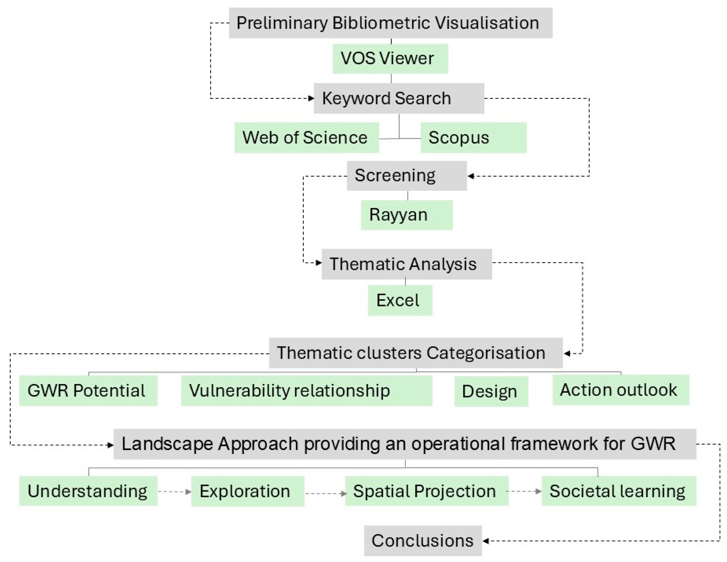
2. Materials and Methods

Firstly, we conducted an exploratory bibliometric visualization using VOS Viewer as a preliminary tool to examine trends and identify gaps in the existing literature on “groundwater recharge” [30]. VOS Viewer is a Java-based software program version 1.6.19 used to create colored maps from bibliographic data and visualize and dig the intrinsic meaning of the maps. We used network maps to represent the significant research clusters among current bibliometric data [31]. Next, we defined three primary keywords: “groundwater recharge”, “landscape”, and “spatial planning”. We included two multidisciplinary databases, Web of Science (WOS) and Scopus, to obtain robust datasets and a wide range of records from different disciplines, including natural science, social science, arts, and the humanities, on the relationship between GWR, the landscape, and spatial planning. These databases were also chosen for their extensive coverage of the scientific literature and for being recognized as high-quality and credible information resources. Then, we selected the related keywords to reflect the key research themes, and the keywords were expanded with associated terms to ensure comprehensive coverage of the relevant literature (Table 2).
The three groups of keywords were combined using the “AND” operation to retrieve articles relevant to the specific research topic. We performed searches on titles, abstracts, and keywords for both databases. The search was limited to studies published between 1990 and 2024, with English as the language option. Following the PRISMA guidelines [32], 257 results were obtained from Scopus and 116 from Web of Science on 6 May 2024 (Figure 2).
To facilitate initial screening and the removal of duplicates, we used Rayyan [33], an advanced web-based tool designed to assist in systematic review management, particularly in the screening and inclusion/exclusion process. After removing 96 duplicates, we further screened the remaining 277 records based on the inclusion and exclusion criteria and their accessibility. The inclusion criteria were (1) empirical research studies and (2) studies relevant to spatial planning or landscape. The exclusion criteria were (1) studies not focused on groundwater (GW) and groundwater recharge (GWR) as the research theme (52 studies), (2) studies that did not integrate spatial planning (4 studies), and (3) studies with irrelevant methodological approaches (17 studies). Additionally, 60 studies were excluded because they were not accessible or had broken links, and 18 records were removed as they were previous literature reviews.
We also employed inductive thematic analysis to identify different themes within the literature. This thematic analysis followed the approach outlined by Braun and Clarke [34]. After the first round of screening, we thematically clustered the 126 remaining records based on their objectives, relevance to spatial planning and the landscape, methodologies, and findings using Excel. Subsequently, the findings from the literature were synthesized and applied to develop a framework for landscape-based groundwater recharge [35], and conclusions were drawn based on the analysis (Figure 1). After all the authors discussed the selected groups of keywords and inclusion and exclusion criteria, the first author screened the studies and performed categorization and organization in Excel and Rayyan. This process and the results were discussed and validated weekly by the other two authors to resolve conflicts and bias and assess certainty. This also helped in the thematic categorization of different records and in forming an outlook toward landscape-based groundwater recharge in the existing literature.

3. Results

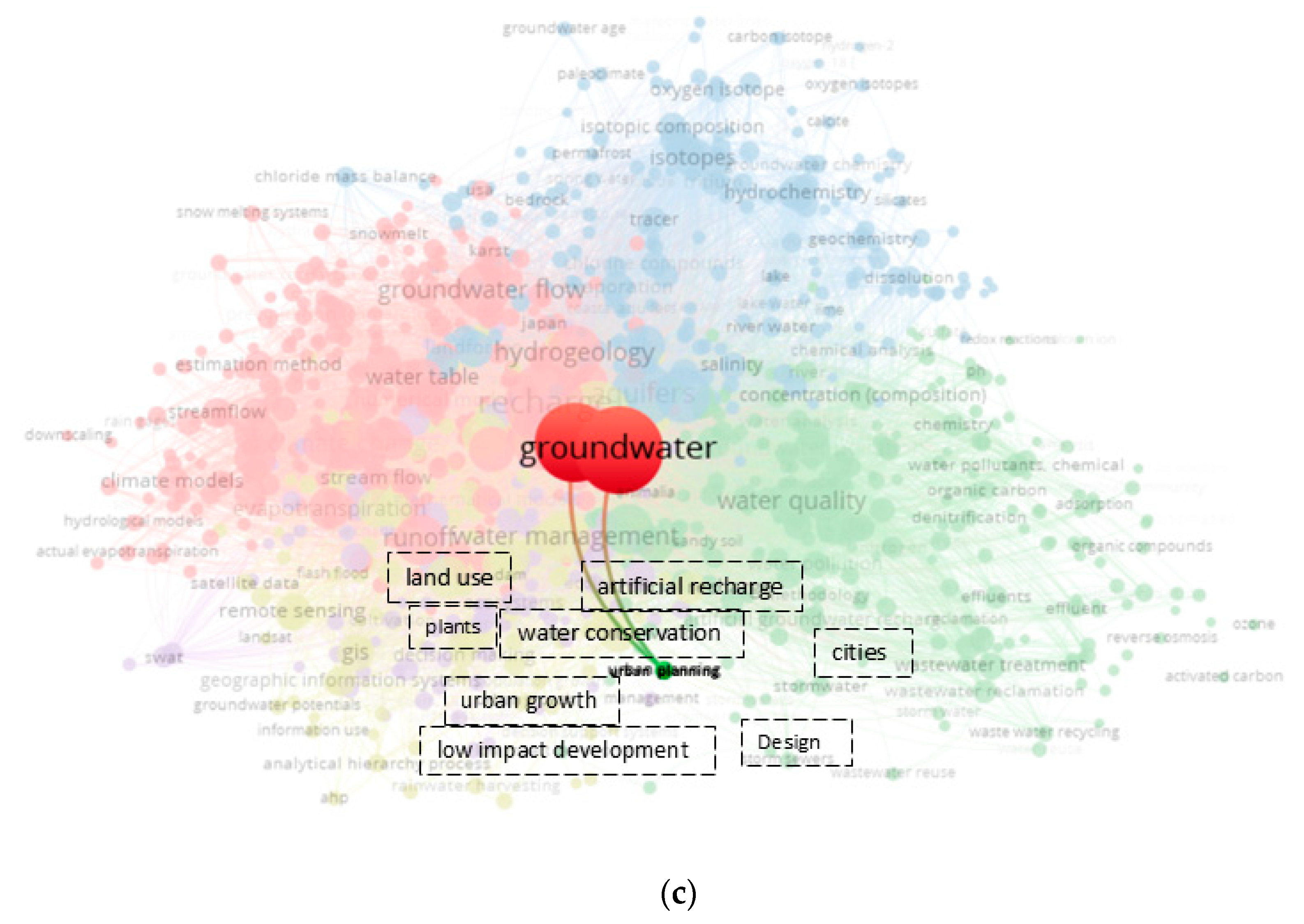
3.1. Visualization Analysis

The bibliometric visualization results showed key groundwater recharge (GWR) research trends. This highlighted a focus on its quality, flow, climate change impacts, and analytical techniques. Notably, we found that urban planning is a minor area of interest and is disconnected from related themes such as design, development, land use, and landscape features. This gap will be further explored in Section 3.2.
A comparative analysis of annual publication trends in the Web of Science (WOS) and Scopus databases from 1990 to 2024 indicates a general increase in publications, although with noticeable fluctuations. There were no publications in WOS from 1990 to 1995, while Scopus saw a decline in publications between 2008 and 2015, with a notable increase in 2018. Since data were retrieved in early May 2024, the number of publications for that year is still lower than expected, but this number is likely to rise by the end of the year (Figure 3).
The spatial distribution of the studies is fragmented, with the United States contributing to the most publications (14), followed by China (13) (Figure 4). Discipline-wise, most studies in both databases fall under environmental sciences (46% in WOS and 38.8% in Scopus), followed by Earth and planetary sciences in Scopus and water resources in WOS. Interestingly, there is no significant association between urban planning and landscape design disciplines (Figure 5). However, the research demonstrates strong connections with ecology, geography, computer science, mathematics, and civil engineering, highlighting the multidisciplinary nature of groundwater recharge studies.
We systematically categorized the studies based on their objectives, relevance to spatial planning and the landscape, methodologies, and findings. In total, six thematic clusters were identified, which were subsequently merged into four main areas. These clusters represent the major themes emerging from the literature on groundwater recharge (GWR) about spatial planning and the landscape:
  • Groundwater Recharge Potential Mapping: studies focusing on identifying and mapping areas with high groundwater recharge potential.
  • Vulnerable relationship between climate change, urban landscape, and groundwater hydrology: research underscoring the vulnerable relationship between climate change and urban landscapes and factors affecting groundwater recharge and hydrological processes.
  • Spatial Design in Groundwater Recharge: studies exploring spatial design interventions such as green infrastructure, water-sensitive urban design (WSUD), and landscape planning to enhance groundwater recharge.
  • Participatory outlook: research focused on participatory approaches in groundwater management, emphasizing community and stakeholder engagement and collaborative decision-making processes.
These four thematic clusters highlight key areas of research that intersect with spatial planning and the landscape, offering spatial insights into sustainable groundwater recharge and ecosystem management strategies. It is also clear from Table 3 that vulnerability studies, particularly those focusing on the intersection of climate change and groundwater, dominate the literature, with a high concentration of studies addressing the role of groundwater in ecosystem services.

3.2. Thematic Categorization in the Groundwater Recharge Literature from a Spatial Planning and Landscape Perspective

3.2.1. GWR Potential Mapping

Groundwater recharge potential mapping studies render the relationship between spatial and hydrological layers (both surface and sub-surface) to estimate the influence of different landscape factors on groundwater hydrology. These studies identified optimal GWR locations on different scales using GIS-based analysis, machine learning, and statistical models. We found six studies in this cluster, five from arid and semi-arid regions, where groundwater recharge is crucial for water security and resilience.
The research outcomes include comprehensive maps of the landscape composition (geomorphology, geological conditions, and soil conditions), land use practices (Urban, infrastructure, agriculture), socio-cultural influences (administrative and cultural landscapes), hydrology-related ecosystems (surface water bodies and existing aquifers), and suitability mapping to find the optimum landscape conditions for GWR. Integrating remote sensing data has made these analyses cost-effective and more accessible.
Various decision-making frameworks enhance the reliability of these studies. For example, the analytical hierarchy process (AHP) systematically assigns weights to different landscape factors that impact groundwater recharge [36,37]. However, the analytical network process (ANP) accounts for interdependencies and feedback loops among input factors, addressing potential subjectivity in AHP-based models [38]. Advanced machine learning algorithms and hybrid approaches further improve the accuracy of GWR potential mapping [39,40] (Table 4).
Validation techniques such as groundwater level data analysis, sensitivity testing, and incorporating human perceptions strengthen the reliability and applicability of these studies [37,39,40,41]. These methods provide a holistic framework for understanding and planning GWR’s potential, particularly in regions with critical groundwater reliance.

3.2.2. Vulnerability Studies: Understanding the Relationship Between Groundwater, the Urban Landscape, and Climate Change

This cluster explores the two-way relationship between groundwater (GW) and natural and urban landscapes while also emphasizing how both are influenced by climate change and anthropogenic pressures. The studies highlight the vulnerability of GW under current and future scenarios, providing insights into sustainable landscape planning and ecosystem management.

Landscape and Climate Conditions as Indicators of GW Vulnerability

By taking individual or collective urban landscape layers/climate changes as indicators, this section explores how GW quality, quantity, flow, and temperature changes are affected. GW’s vulnerability to pollution calls for context-specific spatial and environmental strategies, interdisciplinary collaboration, and policy integration for sustainable urban and rural development [42]. The spatial divergence between master planning and urban growth trends can severely impact GW conditions, potentially compromising urban water supplies. Hard surfaces, as well as poorly planned landscape interventions, disrupt the terrain context, exacerbating water management challenges [43]. Ecological integration and stakeholder collaboration can help revitalize urban landscapes and optimize GW conditions [44].
Landforms and Soil Conditions as Key Indicators of GW Vulnerability: Landforms and soil conditions are critical for understanding groundwater recharge and contamination risks. For example, Falkowska found that morainic uplands and ablation covers are more suitable for GW storage due to their insulating properties [45]. In contrast, sandy landforms offer poor insulation and are more susceptible to GW pollution because of shallow water tables. At the local scale, isotopic analyses of various urban green spaces during drought revealed that shrublands are the most resilient, showing minimal evapotranspiration losses and maintaining high moisture content, followed by grasslands [46].
High karstification potential areas, typically with significant groundwater vulnerability, pose additional challenges [47]. The EPIK (epikarst, the protective cover, infiltration conditions, and the Karst network) method for karst aquifer vulnerability mapping highlights areas near mining and urban developments as prone to contamination [48]. Additionally, agriculture, grazing, waste dumping, and illegal landfills further deteriorate the GW quality in karst landscapes. In tectonic structures like grabens, which act as accumulation points, excessive water logging exacerbates the challenges of GW management [49]. Urbanization has a particularly critical impact on water resources in arid zones, further complicating GW management.
Landscape Types and Their Impact on GW Flow: Certain landscape types, such as grasslands, the forest cover, and agroforestry, correlate positively with improved GW flow [50,51]. Replacing conventional crops with perennials like switchgrass and short rotation coppice (SRC) in watershed management can also enhance GW recharge [52,53]. However, transitioning landscapes to plantations like blue gum can reduce GW recharge potential [54]. A study by R. Li et al. (2023) examining the effects of urbanization on the water cycle at the basin scale showed that increased agricultural activities and urbanization negatively impact GW quality [55]. Similarly, trees can deplete GW in waterlogged areas or recharge it in drought-prone zones [56].
Role of Urbanization and the Urban Heat Island Effect in Groundwater Vulnerability: Urbanization often results in converting vegetated or forested areas into barren land and, eventually, urbanized spaces. This transition increases runoff, accelerates soil erosion, decreases agricultural activities, and diminishes GW recharge capacity. Furthermore, traditional GW harvesting systems, such as Aflaj, are negatively impacted by these changes [57,58,59,60,61]. Specific urban land uses, such as cemeteries, road salting sites, and areas with reclaimed water containing pharmaceuticals and personal care products, are also known to have a detrimental effect on GW quality because of waste affluents with groundwater [62,63,64,65]. Barren land and pasture positively correlate with GW depth [66].
Dense residential development in low infrastructure and unsewered areas increases contamination risks to GW, particularly in regions with shallow groundwater tables [67]. Unregulated real estate developments cause the over-exploitation of open spaces and wells and disruptions in canal systems, decreasing GWR opportunities. These fragmented changes in the land cover affect larger-scale water systems, reducing GW levels and regional ecosystem services. Furthermore, the lack of integration between local and state-level land use planning and regulation limits the ability to address these challenges effectively [68].
The urban heat island (UHI) effect is positively correlated with increased impermeable surfaces, leading to enhanced runoff, decreased infiltration capacity, and flooding [69]. The effective impervious area (EIA)—a refined metric—is a more accurate indicator of hydrological responses than the total impervious area (TIA) [70]. The EIA index has revealed that sparse vegetation and croplands are associated with positive GW recharge, while urbanized areas with high imperviousness negatively impact GW flow.
Water Bodies and Groundwater Recharge: Urban waterbodies serve as aqua nature-based solutions. They enhance GW recharge and improve resilience to droughts and flooding by providing additional infiltration and seepage opportunities [71]. In areas of high GW tables, groundwater-fed ponds provide stable habitats, benefiting macroinvertebrate biodiversity. In the case of low GW table areas, the water bodies can be a means to increase GW levels by improving precipitation and runoff infiltration. Integrating waterbodies as nature-based solutions in planning and modifications to the water bodies, such as ecological water diversion, positively correlates with improved GW quality, vegetation health, landscape restoration, and support for agricultural activities and tourism, contributing to socio-economic, hydrological, and ecological sustainability [72].
Role of Geological and Geomorphological Features in Groundwater Flow: Urban planning often overlooks the potential for groundwater flooding risk despite geological and geomorphological features being key contributors to flooding in aquifer zones. Features like faults and slopes, which contribute to increased runoff and rising groundwater tables, complicate urban water management, especially in areas far from riparian zones [73]. Physiographic landscape features also indicate the discharge and recharge point of GW [74]. A study in Abu Dhabi by Elmahdy and Mohamed revealed that groundwater flow dynamics differ significantly across various geomorphological surfaces, such as local, intermediate, and regional flows, which are characterized by fresh, brackish, and saline water, respectively [75]. Integrating recharge and discharge systems into urban planning can help identify landscape features that contribute to sustainable groundwater management.
Impact of Surface Cover on Groundwater Temperature: Surface sealing significantly impacts the GW temperature. Impervious surfaces increase GW temperatures [76]. A positive correlation exists between impervious areas and shallow subsurface aquifer temperature magnitudes [77]. Additionally, vertical groundwater flow, which acts as a heat transport mode in shallow depths, diminished after a radius of approximately 175 m.
Monitoring Landscape and Climate Impacts on Groundwater: The “WATERWISE” and “Saxon Academy Landscape Monitoring Approach” (SALMA) are two integrated hydrological models that monitor the impacts of landscape and climate changes on hydrological conditions, providing valuable insights into the long-term sustainability of groundwater systems [78,79]. A high sensitivity of peak discharges to increased precipitation is recorded in grasslands and agricultural areas, which is positively correlated to groundwater levels. Flow retardation in upstream areas can be performed to control the peak discharge in the lower regions. This highlights the significance of a suitable strategy in terms of spatial planning to utilize climate change as an opportunity rather than for GWR [78].
Drought conditions cause humus loss, soil degradation, and conversion to arable land due to climate and anthropogenic influences that have decreased groundwater levels in several areas [79]. Monitoring the landscape conditions and effective planning strategies can also help mitigate these challenges.

Groundwater as a Marker of Landscape Fragility

Groundwater (GW) levels and quality serve as critical indicators of landscape vulnerability, particularly in the context of natural and human-induced hazards. Changes in GW storage are strongly correlated with hazard mitigation and dryland resource management, reflecting its role in buffering against both natural and anthropogenic pressures [80]. Declines in GW levels, for instance, are often precursors to hazards such as landslides, land subsidence, and extreme rainstorm-induced challenges. Excessive GW extraction amplifies landslide risks, emphasizing the need for its monitoring as part of pre-hazard planning and urban development strategies, especially in mountainous terrains [81,82,83,84].
Interactions between GW and the landscape highlight its role in maintaining ecological functions, particularly during water scarcity. Urban natural reserves rely on GW to sustain transpiration rates during dry months and warm nights, ensuring vegetation resilience. Shallow-rooted vegetation, such as grasses, demonstrates greater vulnerability to water table depth fluctuations than deep-rooted trees, which can maintain high evapotranspiration (ET) rates due to adjacent water sources [85,86].
Hazards and Landscape Modifications: Improperly designed vineyard terraces and poorly managed drainage systems exacerbate hydrological instability, erosion, and landslide risks on slopes landslides [87,88]. Similarly, high groundwater coal basins (HGCBs) are highly susceptible to land subsidence and collapse, especially in areas with shallow GW levels and inadequate drainage [89]. In karst terrains, collapse susceptibility is heightened in regions close to springs, roads, and settlements, while areas with vegetation tend to be less vulnerable. Methods like the PI (protective cover and infiltration conditions) model demonstrate how GW elevation significantly influences aquifer vulnerability in these landscapes [90,91].
Urban and Regional Planning Implications: GW levels provide essential data for land use optimization, guiding urban and regional planning efforts. For example, areas with deeper GW tables are better suited for landfill siting due to reduced contamination risks [92]. GW recharge (GWR) is a valuable indicator for ecological-economic zoning [93]. Infiltration systems like vegetated swales and bioretention cells are more effective in deeper GW regions, as they minimize pollutant transfer risks and improve urban water management transfer [94,95]. GW mapping further aids in identifying vulnerable zones for activities such as oil and gas extraction, ensuring environmental safety [96].
In arid and semi-arid regions, GW levels are integral for revising zoning methods for eco-environmental fragility assessments [97]. For instance, urban soil quality in areas with saline shallow GW shows higher levels in forests compared to local and riverside parks, highlighting the role of vegetation in enhancing soil quality [98]. Additionally, conservation practices in exurban housing areas help balance GW demands, social acceptance, and wildlife safety, optimizing landscape management [99].
Agriculture and climate response: GW availability is a cornerstone of irrigation expansion and agroforestry initiatives [100]. Performance indices for GW irrigation systems demonstrate how GW levels, infrastructure, and exploitation affect agricultural outcomes [101]. Crops sensitive to waterlogging require alternative land use strategies informed by ecological and social sustainability criteria [90]. Agroforestry systems in saline GW regions have successfully minimized the water demand while reactivating marginal landscapes, particularly in urban areas [102].
GW also influences forest responses to climate change, with variations observed across groundwater table depths and soil types [103]. Excessive extraction and over-reliance on GW lead to fragmented land use patterns and declining meadows, emphasizing the need for sustainable extraction practices [104]. However, studies suggest that water table depth alone may not be a robust indicator for specific ecosystems, such as peatland vegetation, which rely on a broader range of environmental factors [105].

GW in Ecosystem Services Evaluation

The spatial valuation of regional landscapes links groundwater (GW) with ecosystem services (ESs) and underscores its role in land use planning and policymaking. Integrated spatial arrangements based on prioritization strategies and multi-zoning can mitigate conflicts among ecosystem services. For instance, trade-offs often arise between GW availability for irrigation and biodiversity conservation [106]. A driver–pressure–state–impact–response (DPSIR) framework used to analyze conflicts among ecosystem services for GW and bioenergy crop production under three scenarios (centralized, decentralized, and trend-based) indicated diminishing GW availability in centralized scenarios. However, decentralized scenarios, which showed only minor changes in GW availability, were preferred by stakeholders for their balanced approach [107].
Integrated modeling of GW and land-surface interactions has revealed that urbanization in upland regions has broader impacts on ecosystem yield due to reduced GW influence on land-surface processes, compared to the localized effects observed in lowland areas. This is attributed to feedback loops between root water uptake and lateral flow from nearby water sources. However, implementing high-resolution and high-pixel models for such studies remains challenging in data-scarce regions [108]. A survey by Martínez-Santos et al. in 2021 used multi-layered supervised classification algorithms to map GW-dependent ecosystems in wetlands, highlighting how ecosystem services often extend beyond officially delineated boundaries. The study also emphasized the buffering role of wetlands in aquifer dynamics and GW storage, mapping groundwater-dependent ecosystems using the multi-layer supervised classification [109].
Landscapes surrounded by forests in uplands often function as recharge zones, whereas those adjacent to high-intensity land use usually act as discharge zones [110]. Urban expansion has been shown to reduce ecosystem service values in high GW table coal basins. Conversely, ecosystem service values increase with restoration activities, farmland conversion, and the creation of water bodies [111]. Urban green spaces, wetland restoration, and forested areas support GWR while contributing to high ecosystem service valuations, both ecologically and monetarily [112,113]. Regions with GW are among the most valuable in terms of relative annual ES flows [114].
Agroforestry systems have demonstrated an optimal balance of cultural and regulating ecosystem services, including biodiversity support, GW recharge, and monetization opportunities [115]. Pastures also facilitate GWR but remain vulnerable to climate change-induced GW variability. Through managed aquifer recharge (MAR), forest landscapes can improve GW management in river basins, further enhancing ES provisioning [116].

3.2.3. Spatial Design in Groundwater Recharge

Studies in this cluster are focused on integrating groundwater (GW) in urban landscapes to enhance landscape performance and hydrological conditions. They employ design explorations to visualize potential future landscape scenarios across different scales. This section has two sub-groups: spatial design as a landscape-based GWR tool and groundwater integration in urban water management systems.

Spatial Design as a Tool for Landscape-Based GWR

Thinking of groundwater as a vital resource associated with urban landscapes requires an in-depth understanding of the interactions between groundwater and space. Employing interactive mapping can facilitate an interdisciplinary and integrated approach to spatial planning [117]. A collaborative design studio approach, wherein master planning is seen from a landscape perspective, also offers a potential bridge between academic theory and practical implementation, enhancing infiltration opportunities [118].
In water-scarce cities, the design of socially inclusive multifunctional green spaces, such as stormwater ponds, can play a crucial role in groundwater recharge. These spaces can aid in managed aquifer recharge (MAR), improving infiltration capacity and providing valuable amenity services to local communities [4]. Moreover, low-impact development strategies, i.e., modifying existing urban infrastructures to enhance infiltration, can improve GWR and mitigate urban water stress [119]. Landscape interventions like phytoremediation, constructed wetlands, and rehabilitating abandoned pits can also enhance the quality of groundwater [120,121,122]. Furthermore, designing biofilters with plants to filter nitrogen-contaminated groundwater during the summer months and incorporating stormwater harvesting and treatment systems for the winter season can address water quality concerns in arid regions [123].

GW in an Integrated Urban Water Management Approach

GW is a co-benefit of blue–green infrastructure [124], as it plays a central role in enhancing the resilience of urban water systems. Developing water-sensitive spatial strategies at multiple scales, including local and metropolitan levels, and systematically linking them through stakeholder involvement can provide a comprehensive approach to managing urban water scarcity [125]. The integration of both soft (e.g., green spaces) and complex (e.g., built structures) landscape interventions can restore natural hydrology, increase water conservation, and recharge groundwater aquifers [126].
A significant strategy is the integration of various water flows within urban planning, closing the water cycle loop. While ensuring efficient groundwater management, this approach also connects urban water cycles, landscape practices, and the role of key stakeholders [127]. By integrating socio-ecological data into planning, cities can tailor their approaches to specific contexts [128].
Collaborative and interdisciplinary approaches, such as stormwater infiltration projects to boost groundwater levels, have shown promise in improving green and blue infrastructure. For example, a collaborative urban design project in Denmark majorly improved stormwater infiltration as part of a broader urban water management strategy [129]. Similarly, the sponge city concept (India), focusing on improving stormwater retention and infiltration, holds potential benefits for groundwater recharge. However, the suitability of different sites for deep or shallow infiltration should be carefully considered, particularly in areas with shallow groundwater levels, steep slopes, or saline aquifers [130].
As demonstrated in India, the concept of smart cities supports the reuse of wastelands for groundwater recharge, combining natural and artificial recharge methods and creating cascade systems for storing treated wastewater in urban water bodies. These methods are crucial for combating water scarcity in arid regions [131].
Also, the conjunctive management of groundwater and surface water is significant, especially in limited groundwater supply areas. This approach also encourages protecting river ecosystems under the pressures of climate change and urbanization [132]. Integrated planning that combines artificial recharge with natural groundwater replenishment using reclaimed water can offer sustainable urban water solutions, as seen in various case studies such as reclaimed water projects in Los Angeles and desalination initiatives in Tel Aviv [133,134,135]. Also, integrating groundwater recharge into anti-land subsidence planning and groundwater management can avoid fundamental urban problems [136]. However, sectoral approaches must be overcome to realize the full potential of integrated urban water management [137].

3.2.4. Participatory Outlook

This cluster focuses on research from a social, action, or participatory perspective, highlighting the importance of community involvement and collaborative governance in groundwater recharge (GWR) management. A study by Everard et al. (2018) demonstrated that integrating socio-ecological perspectives in technical solutions enhances resource management and promotes sustainable practices [138]. Involving local communities through interviews and employing frameworks like STEEP (social, technological, ecological, economic, and political) can address the complex relationship between ecosystems and urban development. These participatory approaches often emphasize local-scale, community-driven designs, which integrate green infrastructure development with long-term hydrological impacts. This process involves feedback loops, consultations, and informational sessions to educate communities about their potential exposure to groundwater issues and their role in its management [139].
One example of participatory tools is web-based platforms, such as the SOILCONSWEB-CGI system introduced by Terrible et al. in 2015 [140]. These platforms facilitate stakeholders through inclusive and informed decision-making. This allows for the better management of fragmented urban landscapes. In the same way, geovisualization tools enable cross-scale and cross-level decision-making about groundwater sustainability among various stakeholders, promoting transparency and collaboration in planning [141]. However, limited sectoral knowledge often challenges effective groundwater management. To overcome this, integrating knowledge across different sectors and strengthening local stakeholders and existing structures can promote a polycentric approach to groundwater governance [142].
Conflicts between economic development and ecological restoration and inadequate communication among local stakeholders, scientists, and decision-makers often complicate groundwater management [143]. A solution proposed by Dhakal and Chevalier involves a two-tier governance framework that includes city governments and hydrological districts [144]. This framework highlights decentralization and local management of stormwater to improve stakeholder collaboration, increase groundwater replenishment and landscape improvement, and encourage inter-sectoral cooperation.
From a practical management perspective, assessing the ecological objectives of various stakeholders can lead to developing management strategies that address changes in baseflow and groundwater depth. Bhaskar et al. (2016) proposed a management framework or decision-support tool to monitor water table depth and baseflow change due to urbanization and landscape vulnerabilities [61]. Land use and land cover (LULC) scenarios also help stakeholders prioritize land use changes based on their potential impacts on groundwater and ecosystem services. For instance, in a regional spatial planning study in Jakarta, stakeholders ranked GWR as the third most crucial ecosystem service, following flood mitigation and biodiversity conservation [145]. However, in many regions where stakeholders are highly dependent on groundwater, it is often ranked lower in spatial planning decisions.
Participatory approaches also allow for the definition of dynamic and static LULC future scenarios, enabling stakeholders to assess the potential for increased aquifer recharge [146]. Braune and Xu 2010 highlighted the need for top-down approaches in groundwater resource management in Sub-Saharan Africa, where groundwater is neglected despite its high socio-economic and ecological significance [147]. For such regions, effective management requires political will, systematic organization, and the integration of groundwater into local-scale planning.
Finally, the integration of both top-down (expert-driven) and bottom-up (community-driven) approaches in groundwater protection has been demonstrated in several studies. For example, in a groundwater protection area in Denmark, Vejre considered both approaches to balance the conflicting demands of (local) farmers and experts while enhancing landscape functions and maintaining groundwater quality [148]. This dual approach is vital for resolving conflicts and improving sustainable groundwater management at the local level. Furthermore, Kmoch highlighted the need for a comprehensive nexus of people (stakeholders), green infrastructure, and water interactions at a cross-sectoral scale to address water scarcity issues effectively and promote a holistic approach to groundwater governance [149].

4. Discussion

4.1. Existing Research Trends and Gaps

Though GWR is essentially linked to the landscape system, we observed less discussed contributions of spatial planning and landscapes in the preliminary visualization of the GWR literature. Specific keyword searches also revealed that only 6.3% (8 out of 126) of studies were focused on using spatial design for groundwater recharge. Also, arid regions mostly conduct studies on GWR potential estimation because they rely on GW. We found an increasing yet fluctuating trend in the literature connecting groundwater recharge, landscapes, and spatial planning. These studies utilize a variety of research objectives, scales, and tools ranging from GIS, machine learning, hydrological technicalities, socio-economic focus, and statistical modeling and call for the need for interdisciplinary collaboration between spatial planners, hydrologists, engineers, and different stakeholders to attain a holistic implication of landscape-based groundwater recharge (GWR).
Urban planning and landscape design do not appear in the top 10 background disciplines, which sheds light on the dissociation between GWR and the urban landscape context. Advanced remote sensing and digital modeling have contributed to efficient recharge estimates and optimum scenario generation. However, it also makes the studies very specialized and technical from a landscape design perspective. Though most authors have linked groundwater recharge to a step towards sustainable regional development, they lack a systematic integration of groundwater recharge in urban and regional environments and mostly rely on quantitative methods and results. Hence, there is a need to translate this scientific knowledge as generalized, operative, and adaptive to contextual specifications so that regions with data scarcity, sectoral approaches, and fewer resources can adapt and integrate this knowledge into urban and regional development.

4.2. Role of Remote Sensing and Digital Tools in Groundwater Management

From this review, we found that the use of digital tools in groundwater potential estimation and management is crucial. All the studies utilized remote sensing and digital technology in one way or another to provide valuable insights into groundwater dynamics. Many studies have already been conducted to review the digital tools used in groundwater management (Section 1). These tools can also facilitate the development of sustainable spatial planning strategies when integrated. Remote sensing has been proven powerful for acquiring data in data-scarce regions, the analysis of land use and change in terms of Landsat images, and the vegetation health and cover, which influences the GWR capacity.
Various digital recharge potential modeling and estimation techniques help assess urbanization’s impact on groundwater recharge potential. Regression analysis [72] and contemporary machine learning hybrid intelligence techniques (i.e., FORSKA-G, FORSKA-M, FLDA, BFLDA, and RFLDA) offer a better substitute for groundwater recharge potential estimation as compared to the conventional GWR mapping estimation techniques of AHP and ANP [38,39,40,103]. The MODFLOW model is also one of the most commonly used models to analyze groundwater flow and quality [65].
Scenario modeling is also a powerful tool for visualizing potential futures, enabling communication and conflict resolution between various stakeholders.
On local and neighborhood scales, Piezometers with isotope sensors [71], soil moisture sensors, and water quality sensors also provide real-time onsite information to planners. Web-based participatory platforms like SOILCONSWEB-CGI [140] can also help facilitate inclusive and informed decision-making of various stakeholders, which is vital for groundwater management.

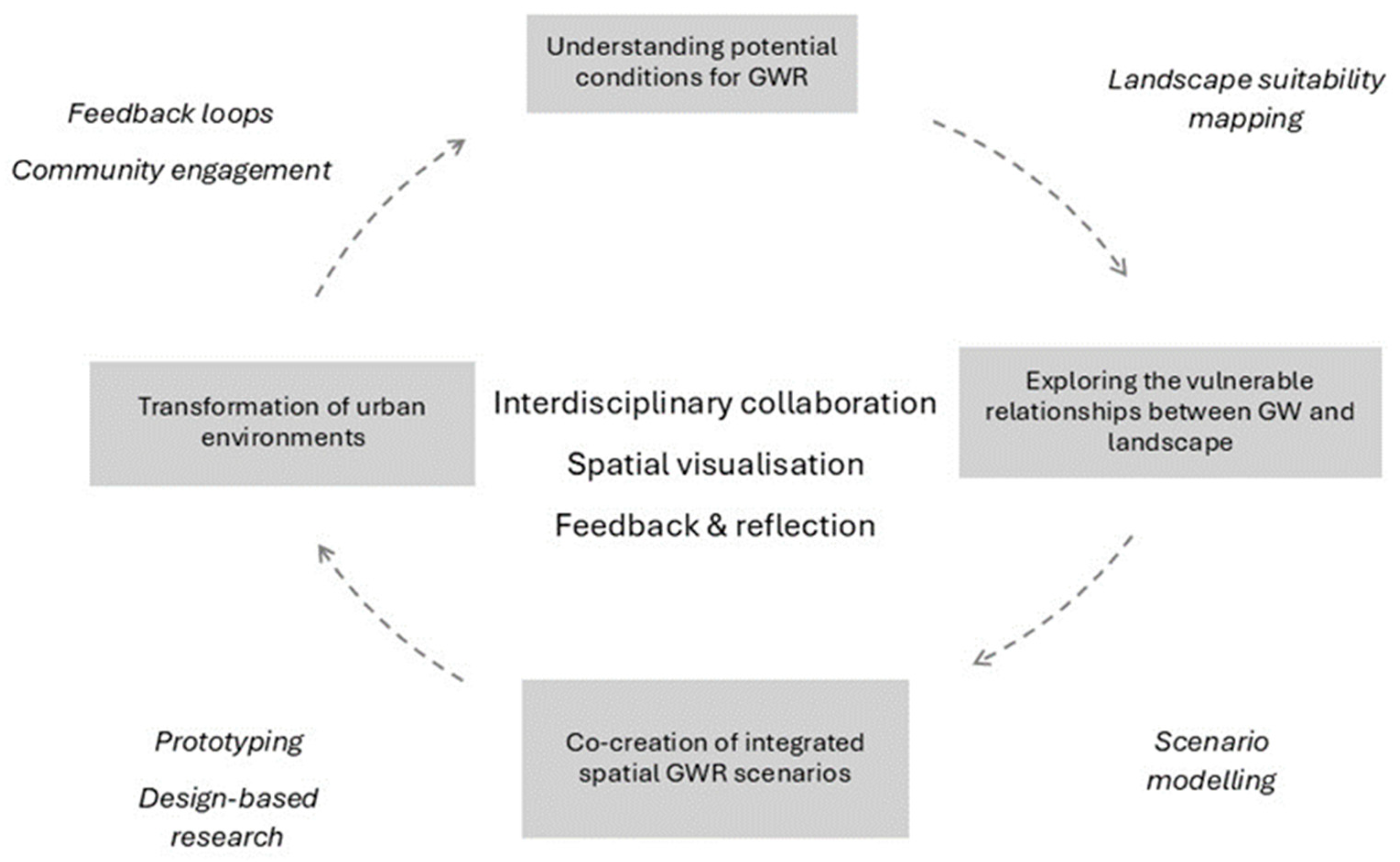
4.3. Development of a Landscape-Based Framework for the Integration of GWR in Spatial Planning

The four literature clusters highlight significant insights into understanding the connection between landscape and groundwater recharge. The cluster of GWR potential studies provides knowledge acquisition of contextual landscape systems by mapping different landscape layers to co-create spatially explicit knowledge. The cluster of vulnerability studies is closely linked to exploring multi-scale spatial relationships between different landscape layers and synergies and conflicts under urban or climate change scenarios. Studies focusing on using spatial design visualizations to forecast future landscape conditions reinforce the importance of the co-creative design process. This also emphasizes the need to integrate multiple spatial-temporal scales, allowing for creating and delivering “transformative knowledge” that can be validated through continuous feedback. It can further develop principles and strategies to apply theoretical knowledge practically. The fourth cluster of action outlook, prototyping GWR spatial solutions and pilot projects, enriches societal learning processes, reflecting upon the whole decision-making process of this transformative knowledge while bridging the gap between design and implementation.
Though each cluster provided valuable insights into groundwater recharge, it also reflects a lack of a holistic approach to the practical implementation of groundwater recharge from a spatial perspective. Hence, we propose integrating these four GWR research clusters as building blocks into an iterative loop to give a holistic understanding of groundwater recharge. This can systematize the existing fragmented and highly technical knowledge into a coherent strategy, helping landscape planners and other stakeholders to navigate complex spatial relationships and environmental dynamics (Figure 6). As a holistic and process-oriented methodology, this aligns with the landscape approach that offers substantial potential to integrate the four research clusters of GWR.
The landscape approach involves the mapping of landscape functions and the co-creation of spatially explicit and context-sensitive knowledge through the continuous loop of understanding, exploring, analyzing, and designing [150,151,152]. In this way, fragmented knowledge in the GWR literature can be systematically integrated to create solutions to real-world issues (pragmatic worldview) [153]. Landscape designers, with their expertise in spatial planning, can play a key role in translating these interdisciplinary concepts into tangible spatial solutions [2]. The relevant research from geography, statistics, computer science, hydrology, environmental science, urban planning, and landscape architecture underscores this opportunity for interdisciplinary collaboration to address GWR-related challenges effectively.
The framework emphasizes the following three core components.
Interdisciplinary collaboration: Collaboration among designers, technical professionals, end-users, and policymakers is essential to co-create socially and ecologically inclusive GWR solutions. Assistance and knowledge-sharing forums can address data scarcity and promote adaptability.
Mapping and visualization tools: Mapping and visualization help to identify, assess, and communicate the potential of GWR in different landscapes. Suitability mapping helps to understand the landscape’s function. Scenario modeling can help explore optimum spatial conditions for GWR. The spatial visualization of technical data assists in creating maximum participation from different stakeholders. It addresses the conflict between ecological, economic, and societal needs by highlighting its relevancy to the specific context. It can improve stakeholder engagement by enabling participatory decision-making processes. This way, diverse groups, including policymakers, developers, and local communities, can understand and evaluate the proposed solutions.
Moreover, for the regions with less favorable natural conditions for infiltration, these tools also evaluate the long-term feasibility of such projects by simulating groundwater dynamics under varying environmental and societal conditions.
Role of design: Design extends the utility of mapping and modeling by enabling the real-world implementation of spatial solutions. It transforms technical insights into tangible, adaptable, and inclusive interventions by integrating social, ecological, and hydrological considerations. For example, incorporating infiltration zones in parks or permeable pavements in public spaces and streets can serve as pilot projects, offering valuable feedback for later improvements in design principles.
Landscape architects can create solutions to enhance recharge potential and improve social acceptance and accessibility by involving communities and other stakeholders in co-creative design processes. This way, design provides “transformative knowledge” by spatially visualizing potential futures and bridging the gap between theory and practice across disciplines. By designing adaptable, multifunctional spatial strategies, planners can accommodate shifting priorities, whether due to climate change, urbanization, cultural norms, or policy changes. This way, landscape-based GWR integrates with broader ecological, esthetic, and recreational goals [150].
Feedback, validation, and reflection: The iterative nature of the landscape-based GWR approach ensures continuous feedback, validation, and reflection loops. This enables planners to address the wicked problem of urban water crises through complex, integrated scenarios [2]. Feedback from the local community and experts is integral for tailoring solutions for regional and cultural preferences, combining top-down and bottom-up planning strategies.

4.4. Limitations

This review is limited to two interdisciplinary academic databases, restricting its scope to documented research. Thus, it overlooks the analysis of practical landscape projects, urban and regional plans, and undocumented community-level initiatives for GWR from a landscape perspective. Also, this reliance on academic databases has excluded policy-driven advancements as it did not include technical reports, policy briefs, and professional planning documents.

5. Conclusions

In this study, we conducted a systematic literature review to examine how spatial planning can contribute to groundwater recharge (GWR). Despite its close connection to the landscape, we hypothesized that GWR is predominantly understood in highly technical and specialized terms within the existing literature. Both broader bibliometric visualization and targeted database search focusing on landscape, spatial planning, and GWR supported this hypothesis that, despite its technical emphasis, GWR is inherently linked to landscape dynamics.
We utilized two interdisciplinary databases, Scopus and Web of Science, to maximize the breadth of assessable results. Our findings indicate that each literature cluster corresponds to a distinct phase or fragment when arranged in an iterative loop, forming the basis of a landscape-based GWR framework. Central to this framework are interdisciplinary collaboration, co-creative design, visualization, and feedback. We linked GWR potential mapping to understanding landscape systems and vulnerability studies to understand the relationships between landscape, urban, and cultural systems. Design-based studies are key to developing integrated spatial solutions, and participatory studies were identified as vital for fostering societal learning. Through this, we propose a landscape-based approach for incorporating GWR into urban planning and regional development, with landscape design as the critical link between scientific research and practical applications.
This study underscores the key role of spatial planners and landscape designers in developing social-ecological spatial GWR solutions. Furthermore, incorporating GWR as a crucial input in urban planning is vital for designing sustainable spatial solutions to contemporary urban challenges.

Future Recommendations

Future research should focus on applying the proposed landscape-based framework in real-world contexts, mainly through pilot projects and case studies, to test the feasibility of GWR interventions. This can hold significant implications in improving the water crisis of developing arid regions that face complex management and infrastructure constraints. Also, policy framework designs facilitating the integration of GWR into urban and regional planning can foster adaptive and context-relevant spatial design solutions. Finally, enhancing groundwater management strategies’ social and cultural relevance on local and regional levels will ensures long-term success and sustainability.

Author Contributions

A.R.: conceptualization, methodology, software, investigation, writing—original draft preparation, and visualization. S.N.: supervision, writing—review and editing, and validation. I.B.: supervision, writing—review and editing, and validation. All authors have read and agreed to the published version of the manuscript.

Funding

This research is funded by the Chief Minister Merit Scholarship, Punjab Educational Endowment Fund Pakistan.

Data Availability Statement

The original contributions presented in the study are included in the review; further data inquiries can be directed to the corresponding author.

Conflicts of Interest

The authors declare no conflicts of interest. There is no role of the funding sponsors in the choice of the research project, design of the study, collection, analysis, interpretation of data, writing the manuscript, or decision to publish the results.

References

  1. Pavlova, D.; Milshina, Y. Sustainable water management in megacities of the future. In Urban Ecology: Emerging Patterns and Social-Ecological Systems; Elsevier: Amsterdam, The Netherlands, 2020; pp. 201–219. [Google Scholar] [CrossRef]
  2. Backhaus, A.; Fryd, O.; Dam, T. Research in Landscape Architecture: Methods and Methodology; Van den Brink, A., Bruns, D., Tobi, H., Bell, S., Eds.; Routledge: London, UK, 2017; pp. 285–304. [Google Scholar]
  3. Irfan, M.; Kazmi, S.J.H.; Arsalan, M.H. Sustainable harnessing of the surface water resources for Karachi: A geographic review. Arab. J. Geosci. 2018, 11, 24. [Google Scholar] [CrossRef]
  4. Mclachlan, J.; Tanyanyiwa, C.T.; Schneuwly, R.; Carden, K.; Armitage, N.P.; Abrams, A.; Mguni, P.; Herslund, L.B. Pathways to water resilient South African cities—From mono-functional to multi-functional stormwater infrastructure. Sci. Afr. 2023, 20, e01674. [Google Scholar] [CrossRef]
  5. Bandari, A.; Sadhukhan, S. Analysis of spatial pattern of water supply continuity in an Indian metropolis: A case study of Hyderabad. Urban Water J. 2024, 21, 839–858. [Google Scholar] [CrossRef]
  6. Ahmad, I.; Hasan, H.; Jilani, M.M.; Ahmed, S.I. Mapping potential groundwater accumulation zones for Karachi city using GIS and AHP techniques. Environ. Monit. Assess. 2023, 195, 381. [Google Scholar] [CrossRef]
  7. UNESCO. The United Nations World Water Development Repot 2022: Groundwater—Making the Invisible Visible Executive Summary; UNESCO: Paris, France, 2022. [Google Scholar]
  8. Chen, Y.; Li, Z.; Fan, Y.; Wang, H.; Deng, H. Progress and prospects of climate change impacts on hydrology in the arid region of northwest China. Environ. Res. 2015, 139, 11–19. [Google Scholar] [CrossRef] [PubMed]
  9. Braga, A.C.R.; Serrao-Neumann, S.; de Oliveira Galvão, C. Groundwater Management in Coastal Areas through Landscape Scale Planning: A Systematic Literature Review. Environ. Manag. 2020, 65, 321–333. [Google Scholar] [CrossRef] [PubMed]
  10. Damania, R.; Desbureaux, S.; Rodella, A.-S.; Russ, J.; Zaveri, E. Quality Unknown: The Invisible Water Crisis; World Bank: Washington, DC, USA, 2019. [Google Scholar] [CrossRef]
  11. Masson-Delmotte, V.; Zhai, P.; Pirani, A.; Connors, S.L.; Péan, C.; Berger, S.; Caud, N.; Chen, Y.; Goldfarb, L.; Gomis, M.I.; et al. Climate Change 2021: The Physical Science Basis. Available online: https://www.ipcc.ch/report/ar6/wg1/ (accessed on 6 January 2025).
  12. Dai, A. Increasing drought under global warming in observations and models. Nat. Clim. Change 2013, 3, 52–58. [Google Scholar] [CrossRef]
  13. Galloway, J.N.; Aber, J.D.; Erisman, J.W.; Seitzinger, S.P.; Howarth, R.W.; Cowling, E.B.; Cosby, B.J. The Nitrogen Cascade. BioScience 2003, 53, 341–356. [Google Scholar] [CrossRef]
  14. Foster, S.S.D.; Chilton, P.J. Groundwater: The processes and global significance of aquifer degradation. R. Soc. 2003, 358, 1957–1972. [Google Scholar] [CrossRef]
  15. Alley, W.M.; Reilly, T.E.; Franke, O.L. Sustainability of Ground-Water Resources. U.S. Deptartment of the Interior, U.S. Geological Survey: Washington, DC, USA, 1999. [Google Scholar]
  16. de Vries, J.J.; Simmers, I. Groundwater recharge: An overview of process and challenges. Hydrogeol. J. 2002, 10, 5–17. [Google Scholar] [CrossRef]
  17. McHarg, I.L. Design with Nature; Natural History Press: Philadelphia, PA, USA, 1969; Available online: https://archive.org/details/designwithnature00mcha/mode/2up (accessed on 16 January 2024).
  18. Reed, J.; Deakin, L.; Sunderland, T. What are ‘Integrated Landscape Approaches’ and how effectively have they been implemented in the tropics: A systematic map protocol. Environ. Evid. 2015, 4, 2. [Google Scholar] [CrossRef]
  19. Adhikari, R.K.; Yilmaz, A.G.; Mainali, B.; Dyson, P.; Imteaz, M.A. Methods of Groundwater Recharge Estimation under Climate Change: A Review. Sustainability 2022, 14, 15619. [Google Scholar] [CrossRef]
  20. Li, M.; Xie, Y.; Dong, Y.; Wang, L.; Zhang, Z. Review: Recent progress on groundwater recharge research in arid and semiarid areas of China. Hydrogeol. J. 2023, 32, 9–30. [Google Scholar] [CrossRef]
  21. Ali, M.; Mubarak, S. Approaches and Methods of Quantifying Natural Groundwater Recharge—A Review. Asian J. Environ. Ecol. 2017, 5, 1–27. [Google Scholar] [CrossRef]
  22. Banerjee, A.; Creedon, L.; Jones, N.; Gill, L.; Gharbia, S. Dynamic Groundwater Contamination Vulnerability Assessment Techniques: A Systematic Review. Hydrology 2023, 10, 182. [Google Scholar] [CrossRef]
  23. Al Atawneh, D.; Cartwright, N.; Bertone, E. Climate change and its impact on the projected values of groundwater recharge: A review. J. Hydrol. 2021, 601, 126602. [Google Scholar] [CrossRef]
  24. Fan, B.; Liu, X.; Zhu, Q.; Qin, G.; Li, J.; Lin, H.; Guo, L. Exploring the interplay between infiltration dynamics and Critical Zone structures with multiscale geophysical imaging: A review. Geoderma 2020, 374, 114431. [Google Scholar] [CrossRef]
  25. Gebru, A.B.; Gebreyohannes, T.; Kahsay, G.H.; Grum, B. The dilemma of choosing appropriate groundwater recharge estimation methods in Ethiopia: A systematic review of the existing methods. Groundw. Sustain. Dev. 2024, 27, 101358. [Google Scholar] [CrossRef]
  26. Zaresefat, M.; Ahrari, M.; Shoaei, G.R.; Etemadifar, M.; Aghamolaie, I.; Derakhshani, R. Identification of Suitable Site-specific Recharge Areas using Fuzzy Analytic Hierarchy Process (FAHP) Technique: A Case Study of Iranshahr Basin (Iran). Air Soil Water Res. 2022, 15, 11786221211063849. [Google Scholar] [CrossRef]
  27. Fujita, T.; Capozzoli, C.R.; Rafee, S.A.A.; de Freitas, E.D. Hydrological Modeling of Urbanized Basins. In Environmental Governance of the São Paulo Macrometropolis; Urban Book Series; Springer: Cham, Switzerland, 2024; Volume Part F3222, pp. 231–240. [Google Scholar] [CrossRef]
  28. Kebede, M.M.; Kumar, M.; Mekonnen, M.M.; Clement, T.P. Enhancing Groundwater Recharge Through Nature-Based Solutions: Benefits and Barriers. Hydrology 2024, 11, 195. [Google Scholar] [CrossRef]
  29. Yimer, E.A.; De Trift, L.; Lobkowicz, I.; Villani, L.; Nossent, J.; van Griensven, A. The underexposed nature-based solutions: A critical state-of-art review on drought mitigation. J. Environ. Manag. 2024, 352, 119903. [Google Scholar] [CrossRef] [PubMed]
  30. Kirby, A. Exploratory Bibliometrics: Using VOSviewer as a Preliminary Research Tool. Publications 2023, 11, 10. [Google Scholar] [CrossRef]
  31. Zhang, H.; Nijhuis, S.; Newton, C. Freshwater blue space design and human health: A comprehensive research mapping based on scientometric analysis. Environ. Impact Assess. Rev. 2022, 97, 106859. [Google Scholar] [CrossRef]
  32. Page, M.J.; McKenzie, J.E.; Bossuyt, P.M.; Boutron, I.; Hoffmann, T.C.; Mulrow, C.D.; Shamseer, L.; Tetzlaff, J.M.; Akl, E.A.; Brennan, S.E.; et al. The PRISMA 2020 statement: An updated guideline for reporting systematic reviews. Int. J. Surg. 2021, 88, 105906. [Google Scholar] [CrossRef] [PubMed]
  33. Ouzzani, M.; Hammady, H.; Fedorowicz, Z.; Elmagarmid, A. Rayyan-a web and mobile app for systematic reviews. Syst. Rev. 2016, 5, 210. [Google Scholar] [CrossRef] [PubMed]
  34. Braun, V.; Clarke, V. Using thematic analysis in psychology. Qual. Res. Psychol. 2006, 3, 77–101. [Google Scholar] [CrossRef]
  35. Lian, J.; Nijhuis, S.; Bracken, G.; Wu, X.; Wu, X.; Chen, D. Conservation and development of the historic garden in a landscape context: A systematic literature review. Landsc. Urban Plan. 2024, 246, 105027. [Google Scholar] [CrossRef]
  36. Bera, K.; Newcomer, M.E.; Banik, P. Groundwater recharge site suitability analysis through multi-influencing factors (MIF) in West Bengal dry-land areas, West Bengal, India. Acta Geochim. 2022, 41, 1030–1048. [Google Scholar] [CrossRef]
  37. Gizaw, E.A.; Bawoke, G.T.; Alemu, M.M.; Anteneh, Z.L. Spatial analysis of groundwater potential using remote sensing and GIS-based multi-criteria decision analysis method in Fetam-Yisir catchment, Blue Nile Basin, Ethiopia. Appl. Geomatics 2023, 15, 659–681. [Google Scholar] [CrossRef]
  38. Singha, S.; Pasupuleti, S. Delineation of Groundwater Prospect Zones in Arang Block, Raipur District, Chhattisgarh, Central India, Using Analytical Network Process. J. Geol. Soc. India 2020, 95, 609–615. [Google Scholar] [CrossRef]
  39. De Souza, E.; Pontes, L.M.; Filho, E.I.F.; Schaefer, C.E.G.R.; Santos, E.E.D. Spatial and temporal potential groundwater recharge: The case of the doce river basin, Brazil. Rev. Bras. De Cienc. Do Solo 2019, 43, e0180010. [Google Scholar] [CrossRef]
  40. Chen, W.; Pradhan, B.; Li, S.; Shahabi, H.; Rizeei, H.M.; Hou, E.; Wang, S. Novel Hybrid Integration Approach of Bagging-Based Fisher’s Linear Discriminant Function for Groundwater Potential Analysis. Nat. Resour. Res. 2019, 28, 1239–1258. [Google Scholar] [CrossRef]
  41. Das, M.; Parveen, T.; Ghosh, D.; Alam, J. Assessing groundwater status and human perception in drought-prone areas: A case of Bankura-I and Bankura-II blocks, West Bengal (India). Environ. Earth Sci. 2021, 80, 636. [Google Scholar] [CrossRef]
  42. Collin, M.L.; Melloul, A.J. Assessing groundwater vulnerability to pollution to promote sustainable urban and rural development. J. Clean. Prod. 2003, 11, 727–736. [Google Scholar] [CrossRef]
  43. Nalini, N.S. Urbanisation and changing temperature patterns in the city of Bengaluru. Environ. Dev. Sustain. 2021, 23, 9090–9109. [Google Scholar] [CrossRef]
  44. Tomaškinová, J.; Tomaškin, J. Assessment of anthropogenic activity negative impact on the karst landscape and a proposal for revitalization measures. Carpathian J. Earth Environ. Sci. 2014, 9, 117–123. [Google Scholar]
  45. Falkowska, E. The significance of morphogenetic analysis in the assessment of soil-water conditions in Quaternary sediments. Geomorphology 2015, 246, 420–432. [Google Scholar] [CrossRef]
  46. Kuhlemann, L.-M.; Tetzlaff, D.; Smith, A.; Kleinschmit, B.; Soulsby, C. Using soil water isotopes to infer the influence of contrasting urban green space on ecohydrological partitioning. Hydrol. Earth Syst. Sci. 2021, 25, 927–943. [Google Scholar] [CrossRef]
  47. Lumongsod, R.M.G.; Ramos, N.T.; Dimalanta, C.B. Mapping the karstification potential of central Cebu, Philippines using GIS. Environ. Earth Sci. 2022, 81, 449. [Google Scholar] [CrossRef]
  48. Pereira, D.L.; Galvão, P.; Lucon, T.; Fujaco, M.A. Adapting the EPIK method to Brazilian Hydro(geo)logical context of the São Miguel watershed to assess karstic aquifer vulnerability to contamination. J. South Am. Earth Sci. 2018, 90, 191–203. [Google Scholar] [CrossRef]
  49. El-Rayes, A.E.; Arnous, M.O.; Shendi, E.-A.H.; Geriesh, M.H.; Gharib, R.A. Morphotectonic controls on hydro-environmental hazards in rift basins: A case study from Southern Suez Canal Province, Egypt. Geoenvironmental Disasters 2023, 10, 18. [Google Scholar] [CrossRef]
  50. Noriega-Puglisevich, J.A.; Eckhardt, K.I. Hydrological effects of the conversion of tropical montane forest to agricultural land in the central Andes of Peru. Environ. Qual. Manag. 2024, 34, e22221. [Google Scholar] [CrossRef]
  51. Negash, T.W.; Abagale, F.K.; Baatuuwie, B.N. Impact of land-use and land-cover change on watershed hydrology: A case study of Mojo watershed, Ethiopia. Environ. Earth Sci. 2022, 81, 536. [Google Scholar] [CrossRef]
  52. Busch, G. The impact of Short Rotation Coppice cultivation on groundwater recharge—A spatial (planning) perspective. Landbauforsch. Volkenrode 2009, 59, 207–221. [Google Scholar]
  53. Wu, M.; Ha, M.-A. Incorporating conservation practices into the future bioenergy landscape: Water quality and hydrology. In Bioenergy and Land Use Change; Wiley: Hoboken, NJ, USA, 2017. [Google Scholar] [CrossRef]
  54. Versace, V.L.; Ierodiaconou, D.; Stagnitti, F.; Hamilton, A.J. Appraisal of random and systematic land cover transitions for regional water balance and revegetation strategies. Agric. Ecosyst. Environ. 2008, 123, 328–336. [Google Scholar] [CrossRef]
  55. Li, R.; Zhu, G.; Lu, S.; Sang, L.; Meng, G.; Chen, L.; Jiao, Y.; Wang, Q. Effects of urbanization on the water cycle in the Shiyang River basin: Based on a stable isotope method. Hydrol. Earth Syst. Sci. 2023, 27, 4437–4452. [Google Scholar] [CrossRef]
  56. Dagar, J.C. Opportunities for Alternate Land Uses in Salty and Water Scarcity Areas. Int. J. Ecol. Environ. Sci. 2009, 35, 53–66. [Google Scholar]
  57. Al-Kindi, K.M.; Alqurashi, A.F.; Al-Ghafri, A.; Power, D. Assessing the Impact of Land Use and Land Cover Changes on Aflaj Systems over a 36-Year Period. Remote Sens. 2023, 15, 1787. [Google Scholar] [CrossRef]
  58. Vaddiraju, S.C.; Reshma, T. Urbanization implications on hydro-meteorological parameters of Saroor Nagar Watershed of Telangana. Environ. Chall. 2022, 8, 100562. [Google Scholar] [CrossRef]
  59. Randhir, T.O.; Tsvetkova, O. Spatiotemporal dynamics of landscape pattern and hydrologic process in watershed systems. J. Hydrol. 2011, 404, 1–12. [Google Scholar] [CrossRef]
  60. Ramli, I.; Achmad, A.; Anhar, A.; Izzaty, A. Landscape patterns changes and relation to water infiltration of Krueng Peusangan Watershed in Aceh. IOP Conf. Series Earth Environ. Sci. 2021, 916, 012017. [Google Scholar] [CrossRef]
  61. Bhaskar, A.S.; Beesley, L.; Burns, M.J.; Fletcher, T.D.; Hamel, P.; Oldham, C.E.; Roy, A.H. Will it rise or will it fall? Managing the complex effects of urbanization on base flow. In Freshwater Science; University of Chicago Press: Chicago, IL, USA, 2016; pp. 293–310. [Google Scholar] [CrossRef]
  62. Leonard, L.S. Assessment of groundwater quality along cemeteries and associated potential health concerns in Dar es Salaam, Tanzania. Water Pract. Technol. 2022, 17, 1218–1229. [Google Scholar] [CrossRef]
  63. Lyu, S.; Chen, W.; Qian, J.; Wen, X.; Xu, J. Prioritizing environmental risks of pharmaceuticals and personal care products in reclaimed water on urban green space in Beijing. Sci. Total Environ. 2019, 697, 133850. [Google Scholar] [CrossRef]
  64. Bester, M.L.; Frind, E.O.; Molson, J.W.; Rudolph, D.L. Numerical investigation of road salt impact on an urban wellfield. Groundwater 2006, 44, 165–175. [Google Scholar] [CrossRef] [PubMed]
  65. Fatta, D.; Naoum, D.; Loizidou, M. Integrated environmental monitoring and simulation system for use as a management decision support tool in urban areas. J. Environ. Manag. 2002, 64, 333–343. [Google Scholar] [CrossRef]
  66. Gao, N.N.; Li, F.; Zeng, H.; Zheng, Y.R. The impact of human activities, natural factors and climate time-lag effects over 33 years in the heihe river basin, china. Appl. Ecol. Environ. Res. 2021, 19, 1589–1606. [Google Scholar] [CrossRef]
  67. Lagro, J.A.; Vowels, B.T.; Vondra, B. Exurban housing development, onsite wastewater disposal, and groundwater vulnerability within a changing policy context. Landsc. Urban Plan. 2017, 167, 60–71. [Google Scholar] [CrossRef]
  68. Baker, J.M.; Everett, Y.; Liegel, L.; Van Kirk, R. Patterns of Irrigated Agricultural Land Conversion in a Western U.S. Watershed: Implications for Landscape-Level Water Management and Land-Use Planning. Soc. Nat. Resour. 2014, 27, 1145–1160. [Google Scholar] [CrossRef]
  69. de Lima, G.N.; Fonseca-Salazar, M.A.; Campo, J. Urban growth and loss of green spaces in the metropolitan areas of São Paulo and Mexico City: Effects of land-cover changes on climate and water flow regulation. Urban Ecosyst. 2023, 26, 1739–1752. [Google Scholar] [CrossRef]
  70. Balha, A.; Singh, A.; Pandey, S.; Kumar, R.; Mallick, J.; Singh, C.K. Assessing the Impact of Land-Use Dynamics to Predict the Changes in Hydrological Variables Using Effective Impervious Area (EIA). Water Resour. Manag. 2023, 37, 3999–4014. [Google Scholar] [CrossRef]
  71. Muñoz, S.M.; Schoelynck, J.; Tetzlaff, D.; Debbaut, R.; Warter, M.; Staes, J. Assessing biodiversity and regulatory ecosystem services in urban water bodies which serve as aqua-Nature-based Solutions. Front. Environ. Sci. 2023, 11, 1304347. [Google Scholar] [CrossRef]
  72. Lu, Z.; Feng, Q.; Xiao, S.; Xie, J.; Zou, S.; Yang, Q.; Si, J. The impacts of the ecological water diversion project on the ecology-hydrology-economy nexus in the lower reaches in an inland river basin. Resour. Conserv. Recycl. 2021, 164, 105154. [Google Scholar] [CrossRef]
  73. Gotkowitz, M.B.; Attig, J.W.; McDermott, T. Inondation par les eaux souterraines d’une terrasse fluvial dans le sud-ouest du Wisconsin, Etats Unis d’Amérique. Hydrogeol. J. 2014, 22, 1421–1432. [Google Scholar] [CrossRef]
  74. Batelaan, O.; De Smedt, F.; Triest, L. Regional groundwater discharge: Phreatophyte mapping, groundwater modelling and impact analysis of land-use change. J. Hydrol. 2003, 275, 86–108. [Google Scholar] [CrossRef]
  75. Elmahdy, S.I.; Mohamed, M.M. Groundwater of Abu Dhabi Emirate: A regional assessment by means of remote sensing and geographic information system. Arab. J. Geosci. 2015, 8, 11279–11292. [Google Scholar] [CrossRef]
  76. Böttcher, F.; Zosseder, K. Thermal influences on groundwater in urban environments—A multivariate statistical analysis of the subsurface heat island effect in Munich. Sci. Total. Environ. 2021, 810, 152193. [Google Scholar] [CrossRef]
  77. Gunawardhana, L.N.; Kazama, S. Using subsurface temperatures to derive the spatial extent of the land use change effect. J. Hydrol. 2012, 460–461, 40–51. [Google Scholar] [CrossRef]
  78. Van Walsum, P.E.V.; Runhaar, J.; Helming, J.F.M. Spatial planning for adapting to climate change. Water Sci. Technol. 2005, 51, 45–52. [Google Scholar] [CrossRef]
  79. Syrbe, R.U.; Bastian, O.; Röder, M.; James, P. A framework for monitoring landscape functions: The Saxon Academy Landscape Monitoring Approach (SALMA), exemplified by soil investigations in the Kleine Spree floodplain (Saxony, Germany). Landsc. Urban Plan. 2007, 79, 190–199. [Google Scholar] [CrossRef]
  80. Ghosh, A.; Bhattacharjee, S.; Bera, B. Hydro-Geomorphological Mapping of Manbhum-Singhbhum Plateau (Part of Singhbhum Protocontinent, India) for Water Resource Development and Landuse Planning. J. Indian Soc. Remote Sens. 2023, 51, 1757–1775. [Google Scholar] [CrossRef]
  81. Avtar, R.; Singh, C.K.; Singh, G.; Verma, R.L.; Mukherjee, S.; Sawada, H. Landslide susceptibility zonation study using remote sensing and GIS technology in the Ken-Betwa River Link area, India. Bull. Eng. Geol. Environ. 2011, 70, 595–606. [Google Scholar] [CrossRef]
  82. Benzenine, F.; Allal, M.A.; Abdelbaki, C.; Kumar, N.; Goosen, M.; Gathenya, J.M. Multi-Hazard Risk Assessment and Landslide Susceptibility Mapping: A Case Study from Bensekrane in Algeria. Sustainability 2023, 15, 2812. [Google Scholar] [CrossRef]
  83. Liu, Q.; Jian, W.; Nie, W. Sustainable Cities and Society 69 (2021) 102817 Rainstorm-induced landslides early warning system in mountainous cities based on groundwater level change fast prediction. Sustain. Cities Soc. 2021, 69, 102817. [Google Scholar] [CrossRef]
  84. Wen, T.; Tiewang, W.; Arabameri, A.; Nalivan, O.A.; Pal, S.C.; Saha, A.; Costache, R. Land-subsidence susceptibility mapping: Assessment of an adaptive neuro-fuzzy inference system–genetic algorithm hybrid modell. Geocarto Int. 2022, 37, 12194–12218. [Google Scholar] [CrossRef]
  85. Marchionni, V.; Guyot, A.; Tapper, N.; Walker, J.P.; Daly, E. Water balance and tree water use dynamics in remnant urban reserves. J. Hydrol. 2019, 575, 343–353. [Google Scholar] [CrossRef]
  86. Arden, S.; Ma, X.; Brown, M. An ecohydrologic model for a shallow groundwater urban environment. Water Sci. Technol. 2014, 70, 1789–1797. [Google Scholar] [CrossRef]
  87. Božiček, B.; Koren, E. Management of Landslides in Small Settlements in Slovenia. In Advancing Culture of Living with Landslides; Springer International Publishing: Berlin/Heidelberg, Germany, 2017; pp. 989–998. [Google Scholar] [CrossRef]
  88. Falconi, L.; Leoni, G.; Arestegui, P.M.; Puglisi, C.; Savini, S. Geomorphological processes and cultural heritage of Maca and Lari Villages: An opportunity for sustainable tourism development in the Colca Valley (Province of Caylloma, Arequipa, South Perù). In Landslide Science and Practice: Risk Assessment, Management and Mitigation; Springer Science and Business Media Deutschland GmbH: Berlin/Heidelberg, Germany, 2013; pp. 459–465. [Google Scholar] [CrossRef]
  89. Li, Z.; Wu, S.; Zhang, S.; Nie, C.; Li, Y.; Huang, Y. Optimization of land reuse structure in coal mining subsided areas considering regional economic development: A case study in Pei County, China. Sustainability 2020, 12, 3335. [Google Scholar] [CrossRef]
  90. Yilmaz, I. GIS based susceptibility mapping of karst depression in gypsum: A case study from Sivas basin (Turkey). Eng. Geol. 2007, 90, 89–103. [Google Scholar] [CrossRef]
  91. Tziritis, E.; Lombardo, L. Estimation of intrinsic aquifer vulnerability with index-overlay and statistical methods: The case of eastern Kopaida, central Greece. Appl. Water Sci. 2017, 7, 2215–2229. [Google Scholar] [CrossRef]
  92. Fatoyinbo, I.O.; Bello, A.A.; Olajire, O.O.; Oluwaniyi, O.E.; Olabode, O.F.; Aremu, A.L.; Omoniyi, L.A. Municipal solid waste landfill site selection: A geotechnical and geoenvironmental-based geospatial approach. Environ. Earth Sci. 2020, 79, 231. [Google Scholar] [CrossRef]
  93. Crivelenti, R.C.; Bueno, C.R.P.; Pires, J.S.R.; Francisco, J.; Lessi, B.F. Ecological-economic zoning of the city of altinópolis—SP, Brazil. Eng. Agricola 2016, 36, 1218–1228. [Google Scholar] [CrossRef]
  94. Bao, A.; Yu, T.; Xu, W.; Lei, J.; Jiapaer, G.; Chen, X.; Komiljon, T.; Khabibullo, S.; Sagidullaevich, X.B.; Kamalatdin, I. Ecological problems and ecological restoration zoning of the Aral Sea. J. Arid. Land 2024, 16, 315–330. [Google Scholar] [CrossRef]
  95. Foomani, M.S.; Malekmohammadi, B. Site selection of sustainable urban drainage systems using fuzzy logic and multi-criteria decision-making. Water Environ. J. 2020, 34, 584–599. [Google Scholar] [CrossRef]
  96. Esterhuyse, S.; Sokolic, F.; Redelinghuys, N.; Avenant, M.; Kijko, A.; Glazewski, J.; Plit, L.; Kemp, M.; Smit, A.; Vos, A.T.; et al. Vulnerability mapping as a tool to manage the environmental impacts of oil and gas extraction. R. Soc. Open Sci. 2017, 4, 171044. [Google Scholar] [CrossRef]
  97. Xue, S.; Wang, C.; Wu, Y.; Zhou, Q.; Song, Z.; Wu, Y. Revised zoning method for environmental fragility evaluation to desertification in arid–semiarid areas: A case of Dousitu river basin. Environ. Earth Sci. 2021, 80, 541. [Google Scholar] [CrossRef]
  98. Sefati, Z.; Khalilimoghadam, B.; Nadian, H. Assessing urban soil quality by improving the method for soil environmental quality evaluation in a saline groundwater area of Iran. Catena 2019, 173, 471–480. [Google Scholar] [CrossRef]
  99. Nielsen-Pincus, M.; Goldberg, C.S.; Pocewicz, A.; Force, J.E.; Waits, L.P.; Morgan, P.; Vierling, L. Predicted effects of residential development on a northern Idaho landscape under alternative growth management and land protection policies. Landsc. Urban Plan. 2010, 94, 255–263. [Google Scholar] [CrossRef]
  100. Chen, Y.; Paydar, Z. Evaluation of potential irrigation expansion using a spatial fuzzy multi-criteria decision framework. Environ. Model. Softw. 2012, 38, 147–157. [Google Scholar] [CrossRef]
  101. Susilo, H.; Purwantoro, D.; Rahadiansyah, S. Model Performance Index of Ground Water Irrigation Systems in the Karst Mountain Region: Case Study in Gunung Kidul Regency, Yogyakarta. IOP Conf. Series Earth Environ. Sci. 2021, 641, 012014. [Google Scholar] [CrossRef]
  102. Kumar, N.; Khamzina, A.; Tischbein, B.; Knöfel, P.; Conrad, C.; Lamers, J.P.A. Spatio-temporal supply–demand of surface water for agroforestry planning in saline landscape of the lower Amudarya Basin. J. Arid. Environ. 2019, 162, 53–61. [Google Scholar] [CrossRef]
  103. Lasch, P.; Lindner, M.; Ebert, B.; Flechsig, M.; Gerstengarbe, F.; Suckow, F.; Werner, P. Regional impact analysis of climate change on natural and managed forests in the Federal State of Brandenburg, Germany. Environ. Model. Assess. 1999, 4, 273–286. [Google Scholar] [CrossRef]
  104. Langroodi, S.H.M.; Masoum, M.G.; Nasiri, H.; Javi, S.T. Spatial and temporal variability analysis of groundwater quantity to land-use/land-cover change in the Khanmirza agricultural plain in Iran. Arab. J. Geosci. 2015, 8, 8385–8397. [Google Scholar] [CrossRef]
  105. Kasimir, Å.; He, H.; Coria, J.; Nordén, A. Land use of drained peatlands: Greenhouse gas fluxes, plant production, and economics. Glob. Chang. Biol. 2018, 24, 3302–3316. [Google Scholar] [CrossRef] [PubMed]
  106. Hermoso, V.; Cattarino, L.; Linke, S.; Kennard, M.J. Catchment zoning to enhance co-benefits and minimize trade-offs between ecosystem services and freshwater biodiversity conservation. Aquat. Conserv. Mar. Freshw. Ecosyst. 2018, 28, 1004–1014. [Google Scholar] [CrossRef]
  107. Lupp, G.; Steinhäußer, R.; Bastian, O.; Syrbe, R.-U. Impacts of increasing bioenergy use on ecosystem services on nature and society exemplified in the German district of Görlitz. Biomass Bioenergy 2015, 83, 131–140. [Google Scholar] [CrossRef]
  108. Zipper, S.C.; Soylu, M.E.; Kucharik, C.J.; Loheide, S.P. Quantifying indirect groundwater-mediated effects of urbanization on agroecosystem productivity using MODFLOW-AgroIBIS (MAGI), a complete critical zone model. Ecol. Model. 2017, 359, 201–219. [Google Scholar] [CrossRef]
  109. Martínez-Santos, P.; Díaz-Alcaide, S.; De la Hera-Portillo, A.; Gómez-Escalonilla, V. Mapping groundwater-dependent ecosystems by means of multi-layer supervised classification. J. Hydrol. 2021, 603, 126873. [Google Scholar] [CrossRef]
  110. McLaughlin, D.L.; Cohen, M.J. Realizing ecosystem services: Wetland hydrologic function along a gradient of ecosystem condition. Ecol. Appl. 2013, 23, 1619–1631. [Google Scholar] [CrossRef]
  111. Xiao, W.; Fu, Y.; Wang, T.; Lv, X. Effects of land use transitions due to underground coal mining on ecosystem services in high groundwater table areas: A case study in the Yanzhou coalfield. Land Use Policy 2018, 71, 213–221. [Google Scholar] [CrossRef]
  112. Aevermann, T.; Schmude, J. Quantification and monetary valuation of urban ecosystem services in Munich, Germany. Z. Wirtsch. 2015, 59, 188–200. [Google Scholar] [CrossRef]
  113. Pinke, Z.; Kiss, M.; Lövei, G.L. Developing an integrated land use planning system on reclaimed wetlands of the Hungarian Plain using economic valuation of ecosystem services. Ecosyst. Serv. 2018, 30, 299–308. [Google Scholar] [CrossRef]
  114. Tammi, I.; Mustajärvi, K.; Rasinmäki, J. Integrating spatial valuation of ecosystem services into regional planning and development. Ecosyst. Serv. 2017, 26, 329–344. [Google Scholar] [CrossRef]
  115. Bremer, L.L.; Mandle, L.; Trauernicht, C.; Pascua, P.; McMillen, H.L.; Burnett, K.; Wada, C.A.; Kurashima, N.; Quazi, S.A.; Giambelluca, T.; et al. Bringing multiple values to the table: Assessing future land-use and climate change in North Kona, Hawai‘i. Ecol. Soc. 2018, 23, 33. [Google Scholar] [CrossRef]
  116. Ha, L.T.; Bastiaanssen, W.G.M. Determination of Spatially-Distributed Hydrological Ecosystem Services (HESS) in the Red River Delta Using a Calibrated SWAT Model. Sustainability 2023, 15, 6247. [Google Scholar] [CrossRef]
  117. Doyle, M.R.; Thalmann, P.; Parriaux, A. Underground potential for urban sustainability: Mapping resources and their interactions with the Deep City method. Sustainability 2016, 8, 830. [Google Scholar] [CrossRef]
  118. Teal, M.; Huang, C.-S.; Rodiek, J. Open space planning for Travis Country, Austin, Texas: A collaborative design. Landsc. Urban Plan. 1998, 42, 259–268. [Google Scholar] [CrossRef]
  119. Matos, C.; Sá, A.B.; Bentes, I.; Pereira, S.; Bento, R. An approach to the implementation of Low Impact Development measures towards an EcoCampus classification. J. Environ. Manag. 2019, 232, 654–659. [Google Scholar] [CrossRef]
  120. Valujeva, K.; Burlakovs, J.; Grinfelde, I.; Pilecka, J.; Jani, Y.; Hogland, W. Phytoremediation as tool for prevention of contaminant flow to hydrological systems. Res. Rural. Dev. 2018, 188–194. [Google Scholar] [CrossRef]
  121. Boukalová, Z.; Těšitel, J.; Gurung, B.D. Nature-based water treatment solutions and their successful implementation in kathmandu valley, nepal. WIT Trans. Ecol. Environ. 2020, 242, 121–132. [Google Scholar] [CrossRef]
  122. Tang, Y.; Jia, H.F.; Jiang, Q.G.; Wang, J. Comprehensive rehabilitation planning of deserted pits and the case study in plain area of Beijing, China. Landsc. Urban Plan. 2011, 99, 123–132. [Google Scholar] [CrossRef]
  123. Brenner, A.; Cohen, H.; Gradus, O.; Koren, O.; Shandalov, S.; Zinger, Y. Incorporation of Hybrid Biofilters in Water-Sensitive urban Design. Present. Environ. Sustain. Dev. 2019, 13, 167–177. [Google Scholar] [CrossRef]
  124. Kadaverugu, R.; Dhyani, S.; Dasgupta, R.; Kumar, P.; Matli, C. Urban sustainability and resilience building: Blue-green infrastructure for air pollution abatement and realizing multiple co-benefits. In Blue-Green Infrastructure Across Asian Countries: Improving Urban Resilience and Sustainability; Springer Nature: Berlin/Heidelberg, Germany, 2022; pp. 397–417. [Google Scholar] [CrossRef]
  125. Singh, I.; Bakshi, V. Geospatial approach for reducing water stress: Case study of Delhi. In Climate Change, Community Response and Resilience: Insight for Socio-Ecological Sustainability; Elsevier: Amsterdam, The Netherlands, 2023; pp. 467–497. [Google Scholar] [CrossRef]
  126. Novotny, V.; Hill, K. Diffuse pollution abatement—A key component in the integrated effort towards sustainable urban basins. In Water Science and Technology; IWA Publishing: London, UK, 2007; pp. 1–9. [Google Scholar] [CrossRef]
  127. Tjallingii, S. Water flows and urban planning. In Sustainable Urban Environments: An Ecosystem Approach; Springer: Dordrecht, The Netherlands, 2012; pp. 91–111. [Google Scholar] [CrossRef]
  128. Melloul, A.J.; Wollman, S.H. Qualitative hydrological and land-use planning tool for the Israel Coastal aquifer. Sci. Total. Environ. 2003, 309, 1–17. [Google Scholar] [CrossRef] [PubMed]
  129. Fryd, O.; Backhaus, A.; Birch, H.; Fratini, C.F.; Ingvertsen, S.T.; Jeppesen, J.; Panduro, T.E.; Roldin, M.; Jensen, M.B. Water sensitive urban design retrofits in Copenhagen—40% to the sewer, 60% to the city. Water Sci. Technol. 2013, 67, 1945–1952. [Google Scholar] [CrossRef]
  130. Lancia, M.; Zheng, C.; He, X.; Lerner, D.N.; Andrews, C.; Tian, Y. Hydrogeological constraints and opportunities for ‘Sponge City’ development: Shenzhen, southern China. J. Hydrol. Reg. Stud. 2020, 28, 100679. [Google Scholar] [CrossRef]
  131. Chandran, S.; Thiruchelve, S.R.; Dhanasekarapandian, M. Integrated urban water resources management strategy for a smart city in India. Water Supply 2021, 21, 736–749. [Google Scholar] [CrossRef]
  132. Palmer, M.A.; Lettenmaier, D.P.; Poff, N.L.; Postel, S.L.; Richter, B.; Warner, R. Climate change and river ecosystems: Protection and adaptation options. Environ. Manag. 2009, 44, 1053–1068. [Google Scholar] [CrossRef]
  133. Sheikh, B. Long-range planning for water reuse in the city of Los Angeles. Water Sci. Technol. 1991, 24, 11–17. [Google Scholar] [CrossRef]
  134. Panayi, A. Use of a Public Perceptions Study to Assist Policy Making for Reclaimed Water Reuse. Water Development Department Ministry of Agriculture, Natural Resources and Environment Republic of Cyprus. In Proceedings of the 13th International Conference on Environmental Science and Technology, Qingdao, China, 21–23 October 2022. [Google Scholar]
  135. Fertas, L.; Alouat, M.; Benmahamed, H. The Emergence of Irrigated Agriculture in Semi-Arid Zones in the Face of Climate Change and Urbanization in Peri-Urban Areas in Setif, Algeria. Sustainability 2024, 16, 1112. [Google Scholar] [CrossRef]
  136. Roggema, R.; Bruin-Baerts, K. Waterman. In Trends in Urban Design; Springer: Cham, Switzerland, 2023; Volume Part F8. [Google Scholar] [CrossRef]
  137. Alaerts, G.J. Water, physically connected yet institutionally fragmented—Investing in its strategies, asset classes, and organizations. In Financing Investment in Water Security: Recent Developments and Perspectives; Elsevier: Amsterdam, The Netherlands, 2022; pp. 17–55. [Google Scholar] [CrossRef]
  138. Everard, M.; Sharma, O.P.; Vishwakarma, V.K.; Khandal, D.; Sahu, Y.K.; Bhatnagar, R.; Singh, J.K.; Kumar, R.; Nawab, A.; Kumar, A.; et al. Assessing the feasibility of integrating ecosystem-based with engineered water resource governance and management for water security in semi-arid landscapes: A case study in the Banas catchment, Rajasthan, India. Sci. Total. Environ. 2018, 612, 1249–1265. [Google Scholar] [CrossRef]
  139. Newman, G.; Shi, T.; Yao, Z.; Li, D.; Sansom, G.; Kirsch, K.; Casillas, G.; Horney, J. Citizen science-informed community master planning: Land use and built environment changes to increase flood resilience and decrease contaminant exposure. Int. J. Environ. Res. Public Health 2020, 17, 486. [Google Scholar] [CrossRef]
  140. Terribile, F.; Agrillo, A.; Bonfante, A.; Buscemi, G.; Colandrea, M.; D’Antonio, A.; De Mascellis, R.; De Michele, C.; Langella, G.; Manna, P.; et al. A Web-based spatial decision supporting system for land management and soil conservation. Solid Earth 2015, 6, 903–928. [Google Scholar] [CrossRef]
  141. Milz, D.; Zellner, M.; Hoch, C.; Radinsky, J.; Pudlock, K.; Lyons, L. Reconsidering Scale: Using Geographic Information Systems to Support Spatial Planning Conversations. Plan. Pract. Res. 2018, 33, 291–308. [Google Scholar]
  142. Mukuyu, P.; Nyambe, N.; Magombeyi, M.S.; Ebrahim, G.Y. Polycentric Groundwater Governance: Insights from the Kavango-Zambezi Transfrontier Conservation Area. Int. J. Commons 2024, 18, 322–336. [Google Scholar] [CrossRef]
  143. Yang, X.; Dong, J.; White, P.D. The key role of water resources management in ecological restoration in Western China. Geogr. Res. 2006, 44, 146–154. [Google Scholar] [CrossRef]
  144. Dhakal, K.P.; Chevalier, L.R. Urban Stormwater Governance: The Need for a Paradigm Shift. Environ. Manag. 2016, 57, 1112–1124. [Google Scholar] [CrossRef]
  145. Vollmer, D.; Pribadi, D.O.; Remondi, F.; Rustiadi, E.; Grêt-Regamey, A. Prioritizing ecosystem services in rapidly urbanizing river basins: A spatial multi-criteria analytic approach. Sustain. Cities Soc. 2016, 20, 237–252. [Google Scholar] [CrossRef]
  146. Rivas-Tabares, D.; Tarquis, A.M.; De Miguel, Á.; Gobin, A.; Willaarts, B. Enhancing LULC scenarios impact assessment in hydrological dynamics using participatory mapping protocols in semiarid regions. Sci. Total. Environ. 2022, 803, 149906. [Google Scholar] [CrossRef]
  147. Braune, E.; Xu, Y. The role of ground water in sub-Saharan Africa. Groundwater 2010, 48, 229–238. [Google Scholar] [CrossRef]
  148. Vejre, H.; Vesterager, J.P.; Kristensen, L.S.; Primdahl, J. Stakeholder and expert-guided scenarios for agriculture and landscape development in a groundwater protection area. J. Environ. Plan. Manag. 2011, 54, 1169–1187. [Google Scholar] [CrossRef]
  149. Kmoch, L.; Bou-Lahriss, A.; Plieninger, T. Drought threatens agroforestry landscapes and dryland livelihoods in a North African hotspot of environmental change. Landsc. Urban Plan. 2024, 245, 105022. [Google Scholar] [CrossRef]
  150. Nijhuis, S. Landscape-Based Urbanism: Cultivating Urban Landscapes Through Design. In Contemporary Urban Design Thinking; Springer Nature: Berlin/Heidelberg, Germany, 2022; Volume Part F7, pp. 249–277. [Google Scholar] [CrossRef]
  151. Nijhuis, S.; Xiong, L.; Cannatella, D. Towards a Landscape-based Regional Design Approach for Adaptive Transformation in Urbanizing Deltas. Res. Urban. Ser. 2021, 6, 55–80. [Google Scholar] [CrossRef]
  152. Bürgi, M.; Ali, P.; Chowdhury, A.; Heinimann, A.; Hett, C.; Kienast, F.; Mondal, M.K.; Upreti, B.R.; Verburg, P.H. Integrated landscape approach: Closing the gap between theory and application. Sustainability 2017, 9, 1371. [Google Scholar] [CrossRef]
  153. Alpak, E.M.; Özkan, D.G.; Düzenli, T. Systems approach in landscape design: A studio work. Int. J. Technol. Des. Educ. 2017, 28, 593–611. [Google Scholar] [CrossRef]
Figure 1. The flow diagram of this study.
Water 17 00862 g001
Figure 2. The PRISMA framework followed for the systematic literature review.
Water 17 00862 g002
Figure 3. The annual distribution of the studies related to landscape-based GWR (X-axis: years and Y-axis: number of publications).
Water 17 00862 g003
Figure 4. The global distribution of records of landscape-based GWR (Locations plotted with 84% efficiency).
Water 17 00862 g004
Figure 5. (a) The broad visualization result of the GWR literature from VOS Viewer shows five different colored clusters. (b) The division of major clusters based on the themes of the keywords. (c) In the literature, urban planning is a small cluster linked to groundwater. However, it does not show any connection to themes of design, plants, urban growth, low-impact development, or artificial recharge.
Water 17 00862 g005aWater 17 00862 g005b
Figure 6. An iterative framework for landscape-based GWR (source: author).
Water 17 00862 g006
Table 1. Previous groundwater recharge review studies in terms of planning and nature-based/landscape-based solutions.
Author (Year) TitleConclusionsLimitations/Gaps/Further Recommendations
Braga et al. (2020)
[9]
Groundwater Management in Coastal Areas through Landscape Scale Planning: A Systematic Literature ReviewUnderstanding groundwater systems in terms of landscape units in spatial, temporal, and modification dimensions can help to improve groundwater management decisions. Focused on coastal areas.
Kumar et al. (2024)
[28]
Enhancing Groundwater Recharge Through Nature-Based Solutions: Benefits and BarriersNature-based solutions can increase groundwater recharge.Affective planning strategies are needed to enhance NBs for GWR.
Yimer et al. (2024)
[29]
The underexposed nature-based solutions: A critical state-of-the-art review on drought mitigationDespite the potential, nature-based or landscape-based solutions are significantly underexplored, especially on a large scale globally.The role of local stakeholders in enhancing the synergy between land use regulations and groundwater management needs to be explored.
Table 2. List of keywords used in the Scopus and WOS databases.
KW-1KW-2KW-3
Groundwater rechargeLandscapeSpatial planning
Related Keywords
“Groundwater” OR “Groundwater recharge” OR “Aquifer recharge” OR “Groundwater Potential” OR “Managed Aquifer recharge” OR “Groundwater management”“Landscape” OR “Landscape-scale planning” OR “Green space” OR “Landscape design” OR “Vegetation” OR “Landscape approach” OR “Nature-based solutions”“Spatial planning” OR “Land-use planning” OR “Urban Design” OR “urban planning” OR “Regional planning” OR “Regional development” OR “Multiscale planning”
Table 3. Studies distributed in different themes.
ClustersNumbers (Appendix)Total Number
GWR potential mapping68, 74, 78, 91, 98, 1176
Vulnerable relationship between climate change, urban landscape, and groundwater hydrologyLandscape and climate conditions as indicators of groundwater vulnerability7, 8, 10, 11, 12, 14, 15, 16, 18, 20, 21, 25,
30, 36, 37, 38, 39, 42, 44, 49, 50, 54, 56, 71,
72, 88, 89, 90, 92, 93, 99, 101, 102, 104, 107,
109, 110, 111, 112, 118, 119, 120
4284
Groundwater as a marker of landscape fragility4, 6, 17, 23, 28, 29, 33, 35, 40, 52, 57, 59, 60, 69,
73, 75, 77, 80, 82, 83, 84, 87, 94, 95, 97, 100, 114,
115, 124, 125
30
Groundwater in ecosystem service evaluation34, 43, 47, 53, 55, 61, 63, 64, 65, 85, 106, 12612
Spatial design in groundwater rechargeSpatial design to improve GWR5, 27, 46, 67, 70, 76, 108, 127823
GW in an integrated urban water management approach2, 3, 9, 19, 26, 31, 32, 58, 79, 86, 96,
103, 113, 116, 121
15
Participatory outlook13, 22, 24, 41, 45, 48, 51, 62, 66, 81, 105, 122, 12313
Table 4. An overview of studies presented in the cluster of GWR potential mapping.
No.AuthorCountryScaleInput ParametersHighest Influencing ParameterModel/
Methodology
ValidationAdditional Associated Dimension
1De Souza et al. (2019)
[39]
BrazilBasinElevation Rainfall, Land Cover, and Soil Type RainfallRandom Forest Model and BALSEQ (Balance method for the evaluation of Groundwater Recharge Potential) ModelSoil Moisture Data---
2Bara et al. (2022)
[36]
IndiaRegionalSlope, Aspect, Altitude, Drainage Density, Pond Density, LULC, NDVI, Rainfall, Temperature, Lithology, Geomorphology, Lineament, and Soil TypeLULC and LithologyWeighted Overlay Method and AHP
(Analytical Hierarchy Process)
Groundwater Elevation Datasets---
3Das et al. (2021)
[41]
IndiaSub-districtLithology, Geomorphology, Lineament, Soil Type, LULC, Average Slope, and Drainage Density GeomorphologyWeighted Overlay Method and AHP (Analytical Hierarchy process)Groundwater Level Human Adaptation Behavior
4w. Chen et al. (2019)
[40]
ChinaRegionalElevation, Slope, Aspect, Plan Curvature, Profile Curvature, TWI, SPI, STI, Lithology, LULC, NDVI, Distance To Roads, and Distance To StreamsLithologyFLDA
(Fisher’s Linear Discriminant function), BFLDA (Integration Of Fisher’s Linear Discriminant Function With Bagging Ensemble), RFLDA (Integration Of Fisher’s Linear Discriminant Function With Rotation Forest Ensemble)
Friedman Test, Wilcoxon signed-rank Test, and ROC---
5Gizaw et al. (2023)
[37]
EthiopiaSub-Basin/catchmentSlope, Geomorphology, NDVI, Elevation,
Geology, LULC, Soil, Rainfall, and Drainage Density
SlopeWeighted Overlay and AHP (Analytical Hierarchy Process)Boreholes And Spring Yield Data---
6Singha and Pasupuleti (2020)
[38]
IndiaDistrictAquifer, Soil, Geomorphology, Slope, Drainage Density, LULC, NDVI, and RainfallAquiferANP (Analytical Network Process) Groundwater Level---
Disclaimer/Publisher’s Note: The statements, opinions and data contained in all publications are solely those of the individual author(s) and contributor(s) and not of MDPI and/or the editor(s). MDPI and/or the editor(s) disclaim responsibility for any injury to people or property resulting from any ideas, methods, instructions or products referred to in the content.

