
Combination of Large Language Models and Portable Flood Sensors for Community Flood Response: A Preliminary Study


Abstract
1. Introduction
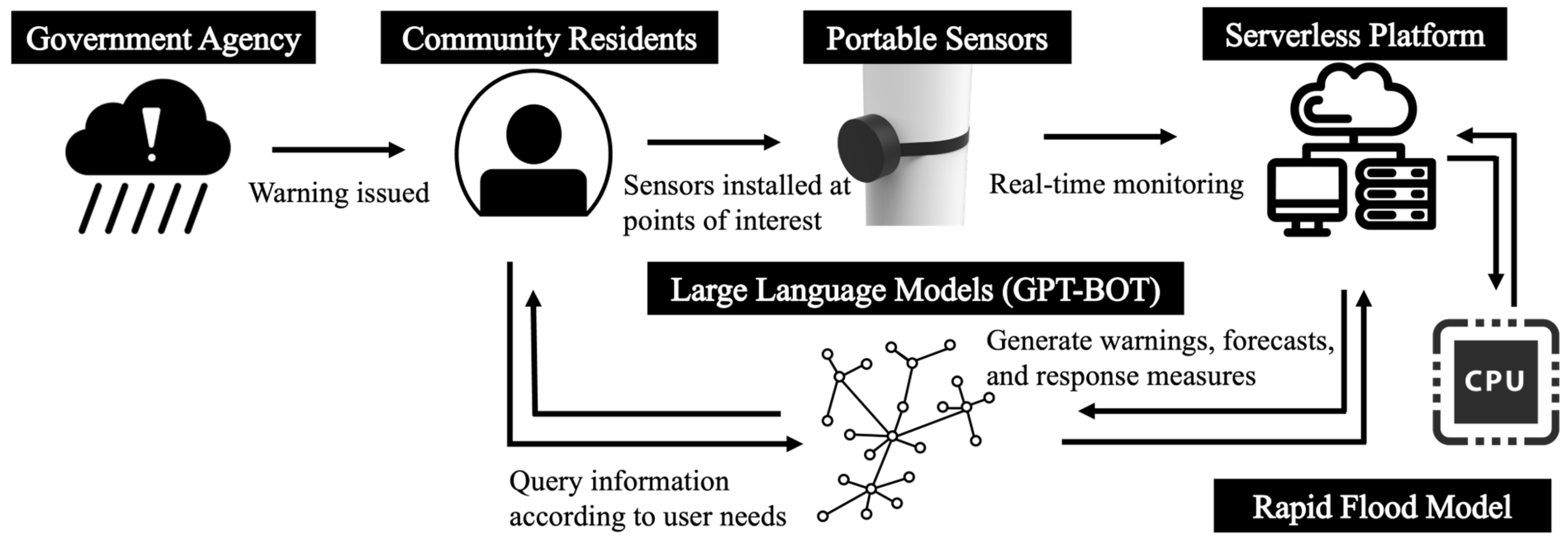
2. Methods
2.1. Portable Flood Sensors
2.2. Rapid Inundation Model
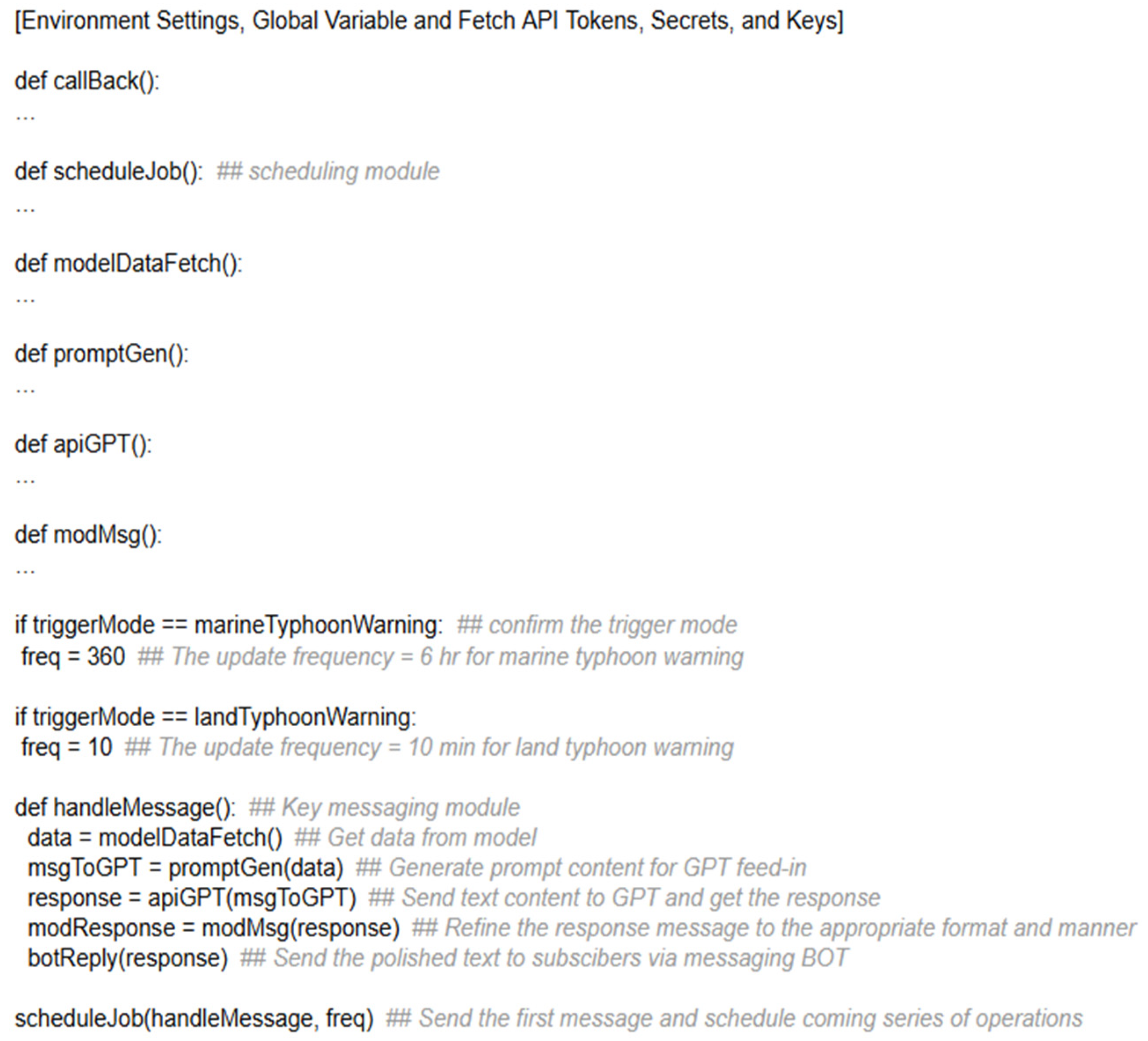
2.3. Large Language Models (LLMs)
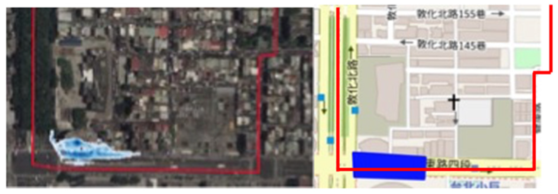
3. Study Area and Data
4. Results
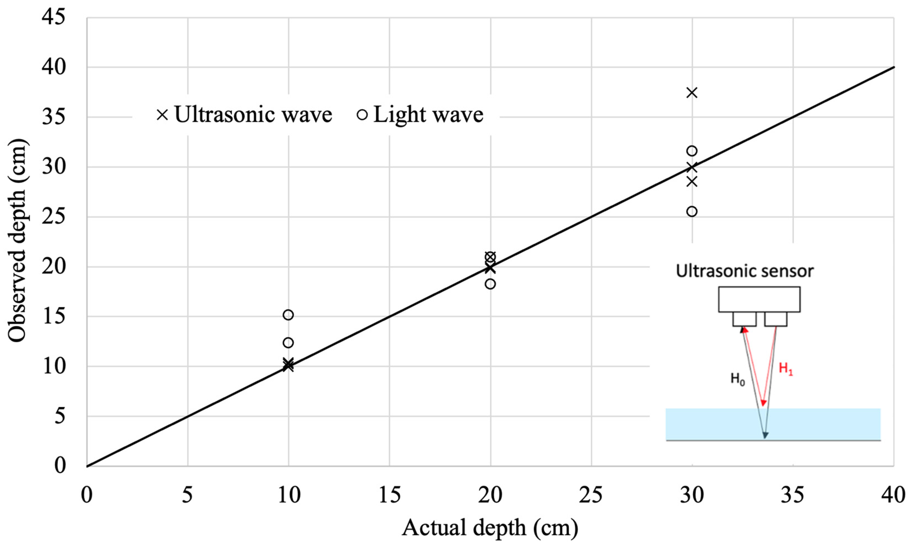
4.1. Modeling Results
4.2. LLM Results
5. Conclusions
Author Contributions
Funding
Data Availability Statement
Acknowledgments
Conflicts of Interest
References
- Centre for Research on the Epidemiology of Disasters (CRED). 2021 Disasters in Numbers; CRED: Brussels, Belgium, 2022. [Google Scholar]
- Togawa, T.; Morita, H.; Tsuji, T. Applying the functional resonance analysis method (FRAM) to flood risk management at a community level: Koriyama city’s emergency-response process during Typhoon Hagibis. Prog. Disaster Sci. 2023, 19, 100291. [Google Scholar] [CrossRef]
- Wolff, E. The promise of a “people-centred” approach to floods: Types of participation in the global literature of citizen science and community-based flood risk reduction in the context of the Sendai Framework. Prog. Disaster Sci. 2021, 10, 100171. [Google Scholar] [CrossRef]
- Webber, J.L.; Fletcher, T.; Farmani, R.; Butler, D.; Melville-Shreeve, P. Moving to a future of smart stormwater management: A review and framework for terminology, research, and future perspectives. Water Res. 2022, 218, 118409. [Google Scholar] [CrossRef] [PubMed]
- Jin, Y.; Kwak, K.S.; Sengoku, M.; Shinoda, S. Wide area sensor network for disaster prevention and monitoring: Concept and service coverage. In Proceedings of the 2014 IEEE Asia Pacific Conference on Circuits and Systems (APCCAS), Ishigaki, Japan, 17–20 November 2014; pp. 391–394. [Google Scholar]
- Tao, Y.; Tian, B.; Adhikari, B.R.; Zuo, Q.; Luo, X.; Di, B. A Review of Cutting-Edge Sensor Technologies for Improved Flood Monitoring and Damage Assessment. Sensors 2024, 24, 7090. [Google Scholar] [CrossRef]
- Raman, R.; Iqbal, S.M.U. IoT-based Flood Early Warning System for Effective Disaster Management. In Proceedings of the 2024 International Conference on E-Mobility, Power Control and Smart Systems (ICEMPS), Thiruvananthapuram, Kerala, India, 18–20 April 2024; pp. 1–5. [Google Scholar]
- Duguma, A.L.; Bai, X. Contribution of Internet of Things (IoT) in improving agricultural systems. Int. J. Environ. Sci. Technol. 2024, 21, 2195–2208. [Google Scholar]
- Abdalzaher, M.S.; Krichen, M.; Falcone, F. Leveraging internet of things and emerging technologies for earthquake disaster management: Challenges and future directions. Prog. Disaster Sci. 2024, 23, 100347. [Google Scholar] [CrossRef]
- Ouaissa, M.; Ouaissa, M.; El Himer, S.; Boulouard, Z. AI and IoT Integration for Natural Disaster Management: A Comprehensive Review and Future Directions. In AI and IoT for Proactive Disaster Management; IGI Global: Hershey, PA, USA, 2024; pp. 1–16. [Google Scholar]
- Wahyono, I.D.; Asfani, K.; Aripriharta; Fadlika, I.; Jong, G.J. New method of artificial intelligence for disaster information floods use distributed wireless sensors. In Proceedings of the 2019 International Seminar on Application for Technology of Information and Communication (iSemantic), Semarang, Indonesia, 21–22 September 2019; pp. 1–5. [Google Scholar]
- Kuller, M.; Schoenholzer, K.; Lienert, J. Creating effective flood warnings: A framework from a critical review. J. Hydrol. 2021, 602, 126708. [Google Scholar] [CrossRef]
- Mendoza-Cano, O.; Aquino-Santos, R.; López-De La Cruz, J.; Edwards, R.M.; Khouakhi, A.; Pattison, I.; Rangel-Licea, V.; Castellanos-Berjan, E.; Martinez-Preciado, M.A.; Rincón-Avalos, P.; et al. Experiments of an IoT-based wireless sensor network for flood monitoring in Colima, Mexico. J. Hydroinformatics 2021, 23, 385–401. [Google Scholar] [CrossRef]
- Al Qundus, J.; Dabbour, K.; Gupta, S.; Meissonier, R.; Paschke, A. Wireless sensor network for AI-based flood disaster detection. Ann. Oper. Res. 2022, 319, 697–719. [Google Scholar] [CrossRef]
- Al-Qurabat, A.K.M.; Abdulzahra, S.A. An overview of periodic wireless sensor networks to the internet of things. IOP Conf. Ser. Mater. Sci. Eng. 2020, 928, 032055. [Google Scholar] [CrossRef]
- Rose, A.; Wei, D.; Machado, J.; Spencer, K. Benefit–cost analysis of low-cost flood inundation sensors. Nat. Hazards Rev. 2023, 24, 05022011. [Google Scholar] [CrossRef]
- Kumbam, P.R.; Vejre, K.M. Floodlense: A framework for chatgpt-based real-time flood detection. arXiv 2024, arXiv:2401.15501. [Google Scholar]
- Zhu, J.; Dang, P.; Cao, Y.; Lai, J.; Guo, Y.; Wang, P.; Li, W. A flood knowledge-constrained large language model interactable with GIS: Enhancing public risk perception of floods. Int. J. Geogr. Inf. Sci. 2024, 38, 603–625. [Google Scholar] [CrossRef]
- Goecks, V.G.; Waytowich, N.R. Disasterresponsegpt: Large language models for accelerated plan of action development in disaster response scenarios. arXiv 2023, arXiv:2306.17271. [Google Scholar]
- Colverd, G.; Darm, P.; Silverberg, L.; Kasmanoff, N. Floodbrain: Flood disaster reporting by web-based retrieval augmented generation with an llm. arXiv 2023, arXiv:2311.02597. [Google Scholar]
- Xue, Z.; Xu, C.; Xu, X. Application of ChatGPT in natural disaster prevention and reduction. Nat. Hazards Res. 2023, 3, 556–562. [Google Scholar] [CrossRef]
- Chandra, A.; Chakraborty, A. Exploring the role of large language models in radiation emergency response. J. Radiol. Prot. 2024, 44, 011510. [Google Scholar] [CrossRef]
- Rollason, E.; Bracken, L.J.; Hardy, R.J.; Large, A.R.G. Rethinking flood risk communication. Nat. Hazards 2018, 92, 1665–1686. [Google Scholar] [CrossRef]
- Lechowska, E. What determines flood risk perception? A review of factors of flood risk perception and relations between its basic elements. Nat. Hazards 2018, 94, 1341–1366. [Google Scholar] [CrossRef]
- Tang, J.; Zhu, X.; Lin, L.; Dong, C.; Zhang, L. Monitoring routing status of UAV networks with NB-IoT. J. Supercomput. 2023, 79, 19064–19094. [Google Scholar] [CrossRef]
- Yang, T.H.; Chen, Y.C.; Chang, Y.C.; Yang, S.C.; Ho, J.Y. Comparison of different grid cell ordering approaches in a simplified inundation model. Water 2015, 7, 438–454. [Google Scholar] [CrossRef]
- Wijaya, O.T.; Yang, T.H. A novel hybrid approach based on cellular automata and a digital elevation model for rapid flood assessment. Water 2021, 13, 1311. [Google Scholar] [CrossRef]
- O’Callaghan, J.F.; Mark, D.M. The extraction of drainage networks from digital elevation data. In Computer Vision and Image Processing; CRC Press: Boca Raton, FL, USA, 1984; Volume 28, pp. 323–344. [Google Scholar] [CrossRef]
- Chang, T.J.; Yu, H.L.; Wang, C.H.; Chen, A.S. Overland-gully-sewer (2D-1D-1D) urban inundation modeling based on cellular automata framework. J. Hydrol. 2021, 603, 127001. [Google Scholar] [CrossRef]


| Block ID | Description |
|---|---|
| A | Manual operation or automated program trigger: Represents the initiating source for system activation, which may originate from either manual operation or predefined automated scheduling. |
| B | Main script in web service (Webhook and HEROKU): A web-service-side script responsible for managing data transmission, reception, API interactions, and data-processing logic. This function is composed by Python and integrates all API interfaces. |
| C | Simulated data from sensors and open weather data: The environmental data sources, comprising real-time sensor data collected from community deployments, as well as climate information obtained via open access weather services. By using HTTP POST and GET methods in Python, the data required are received by the HTTP responses. |
| D | LLM Model (ChatGPT): A natural language processing component leveraging large language models (e.g., OpenAI’s GPT models) tasked with analyzing input data and generating contextually appropriate alert or informational messages. With the pre-prompt configuration setup, fixed prompt content and iterative validation, a stable input information for GPT is delivered to API side. |
| E | Messaging BOT (LINE) in terminal device: A messaging interface integrated within a communication platform (e.g., LINE) that disseminates LLM-generated messages directly to end-users, providing timely alerts or updates regarding potential disaster events. The response is checked by keyword validation, pattern recognition, and content filtering, and eventually delivered to user side. |
| Scenario | (t − ∆t) | Present Observation (t) | Future Forecasts (t + ∆t) |
|---|---|---|---|
| A | No flooding (flood depth = 0 cm) | No flooding (flood depth = 0 cm) | No flooding (flood depth = 0 cm) |
| B | No flooding (flood depth = 0 cm) | Slight flooding (flood depth = 19 cm) | Severe flooding (flood depth = 39 cm) |
| C | No flooding (flood depth = 0 cm) | Severe flooding (flood depth = 38 cm) | Slight flooding (flood depth = 9 cm) |
| D | Slight flooding (flood depth = 7 cm) | Severe flooding (flood depth = 35 cm) | Slight flooding (flood depth = 28 cm) |
| E | Slight flooding (flood depth = 29 cm) | No flooding (flood depth = 0 cm) | Severe flooding (flood depth = 49 cm) |
| F | Slight flooding (flood depth = 26 cm) | Severe flooding (flood depth = 45 cm) | No flooding (flood depth = 0 cm) |
| G | Severe flooding (flood depth = 55 cm) | Slight flooding (flood depth = 21 cm) | No flooding (flood depth = 0 cm) |
| H | Severe flooding (flood depth = 45 cm) | Slight flooding (flood depth = 10 cm) | Severe flooding (flood depth = 36 cm) |
| I | Severe flooding (flood depth = 55 cm) | No flooding (flood depth = 0 cm) | No flooding (flood depth = 0 cm) |
| Scenario | Immediate Actions (Now) | Future Actions (From Now to the Next Time Interval, e.g., 6 h or 10 min Later) |
|---|---|---|
| A | “While there is currently no flooding, remain cautious and stay informed about weather updates. Keep an emergency kit accessible, including essential supplies such as food, water, medications, and a flashlight.” | “Continue to monitor local weather forecasts and be prepared to evacuate if conditions change. Establish a communication plan with family and friends. Reinforce the importance of safeguarding property as a precaution against unexpected flooding.” |
| B | “Avoid low-lying areas and do not attempt to cross flooded roads. Move to higher ground if you are in a flood-prone area. Ensure your emergency kit is ready, including food, water, medications, and flashlight.” | “Stay updated through local news or weather reports for further flooding updates. Prepare to evacuate if the water level rises significantly; follow evacuation orders from authorities. Document any damage for insurance purposes once it is safe to do so.” |
| C | “Evacuate: If you are in a low-lying area or near the affected flood zone, seek higher ground immediately. Stay informed: Monitor local news and weather reports for updates on the flooding situation. Avoid contact: Do not walk or drive through flooded areas. Floodwaters may contain hazardous materials. Prepare: Gather essential items (medications, important documents, food, water) in case of evacuation. “ | “Assess safety: Once water levels decrease, check your property for damage before re-entering. Stay cautious: Remain vigilant, as conditions may change unexpectedly. Report damage: Contact local authorities for assistance and to report any hazards. Stay safe and prioritize your well-being.” |
| D | “Evacuate to higher ground if you are in a flooded area. Avoid driving or walking through flooded streets. Stay updated via local news and weather reports.” | “Monitor water levels; although flooding is expected to decrease, conditions may still be hazardous. Only return home when local authorities have declared it safe. Inspect your property for damage once it is safe, and report any hazards to local services.” |
| E | “Stay alert, and monitor local weather updates. Ensure all drainage systems are clear and functioning properly. Avoid low-lying areas prone to flooding.” | “Prepare an emergency kit with necessary supplies, including food, water, medications, and flashlights. Identify and plan evacuation routes in case of serious flooding. Keep important documents in a waterproof container or digital form. Follow local authorities’ instructions, and evacuate if instructed.” |
| F | “Stay indoors, and avoid flooded areas. Move to higher ground if your location is prone to flooding. Secure important documents and belongings in waterproof containers.” | “Monitor local weather updates and flood advisories. Once conditions stabilize, avoid traveling through floodwaters. Check your property for any damages, and report issues to local authorities. Stay safe and prepared. Follow these instructions carefully to protect yourself and your property.” |
| G | “Stay indoors, and avoid unnecessary travel. Keep emergency supplies ready, including food, water, and a flashlight. Monitor local weather reports and advisories for updates.” | “Once flooding subsides, remain alert for any sudden changes in water levels. If you must go outside, be cautious of slippery surfaces. Report any visible hazards to local authorities, and check on neighbors, especially the elderly and those with disabilities. Stay safe and prepared!” |
| H | “Remain indoors and avoid all travel unless absolutely necessary. Monitor local news and weather reports for updates on flood conditions. Move valuable possessions and important documents to higher ground. If you are in a flood-prone area, prepare an emergency kit with essentials such as food, water, and medications.” | “Be prepared to evacuate if conditions worsen. Stay tuned for alerts from local authorities regarding safety and evacuation routes. Check on neighbors, especially the elderly or those with mobility issues, to ensure their safety.” |
| I | “Monitor local weather reports and flood alerts continuously. Ensure your emergency kit is prepared with essentials such as water, food, and medications.” | “Continue to stay vigilant for changes in weather conditions. Avoid low-lying areas, and stay informed about flood-prone zones in your environment. Communicate with family and neighbors to ensure everyone is aware of the situation and prepared.” |
| System Framework | Advantages | Disadvantages |
|---|---|---|
| LLMs + API + Messenger Integration + Portable Sensors (This Study) | High accuracy, personalized alerts, real-time data integration, scalable, easily updated. | Reliance on stable networks, potential API outages and latency. |
| Automated Warning Systems | Reliable, stable, clearly defined protocols. | Limited flexibility, generalized alerts, potential latency, lack of context. |
| Sensor-Based Alerting Systems | Accurate real-time data, actionable information, immediate response. | Poor coverage, high deployment costs, ambiguous data, lacks centralized communication. |
| Traditional Communication (SMS) | Simple, broad coverage, trusted, and Internet-independent. | Delays, low detail and personalization, prone to human error and inefficiencies. |
Disclaimer/Publisher’s Note: The statements, opinions and data contained in all publications are solely those of the individual author(s) and contributor(s) and not of MDPI and/or the editor(s). MDPI and/or the editor(s) disclaim responsibility for any injury to people or property resulting from any ideas, methods, instructions or products referred to in the content. |
© 2025 by the authors. Licensee MDPI, Basel, Switzerland. This article is an open access article distributed under the terms and conditions of the Creative Commons Attribution (CC BY) license (https://creativecommons.org/licenses/by/4.0/).
Share and Cite
Ou, T.-H.; Yang, T.-H.; Chang, P.-Z. Combination of Large Language Models and Portable Flood Sensors for Community Flood Response: A Preliminary Study. Water 2025, 17, 1055. https://doi.org/10.3390/w17071055
Ou T-H, Yang T-H, Chang P-Z. Combination of Large Language Models and Portable Flood Sensors for Community Flood Response: A Preliminary Study. Water. 2025; 17(7):1055. https://doi.org/10.3390/w17071055
Chicago/Turabian StyleOu, Tsung-Hua, Tsun-Hua Yang, and Pei-Zen Chang. 2025. "Combination of Large Language Models and Portable Flood Sensors for Community Flood Response: A Preliminary Study" Water 17, no. 7: 1055. https://doi.org/10.3390/w17071055
APA StyleOu, T.-H., Yang, T.-H., & Chang, P.-Z. (2025). Combination of Large Language Models and Portable Flood Sensors for Community Flood Response: A Preliminary Study. Water, 17(7), 1055. https://doi.org/10.3390/w17071055