Article

Study on the Deformation Mechanism of Shallow Soil Landslides Under the Coupled Effects of Crack Development, Road Loading, and Rainfall

1
Hubei Yangtze River Three Gorges Landslide National Field Scientific Observation and Research Station, Yichang 443002, China
2
College of Civil and Architecture, China Three Gorges University, Yichang 433002, China
*
Authors to whom correspondence should be addressed.
Water 2025, 17(8), 1196; https://doi.org/10.3390/w17081196
Submission received: 10 March 2025 / Revised: 4 April 2025 / Accepted: 10 April 2025 / Published: 16 April 2025

Abstract

:
This study investigated the deformation characteristics and mechanisms of the Baiyansizu landslide under the coupled effects of crack development, rainfall infiltration, and road loading. Numerical simulations were performed using GeoStudio software (Version 2018; Seequent, 2018) to analyze geological factors and external disturbances affecting landslide deformation and seepage dynamics. Four additional landslides (Tanjiawan, Bazimen, Tudiling, and Chengnan) were selected as comparative cases to investigate differences in deformation characteristics and mechanisms across these cases. The results demonstrate that rear-edge deformation of the Baiyansizu landslide was predominantly governed by rainfall patterns, with effective rainfall exhibiting a dual regulatory mechanism: long-term rainfall reduced shear strength through sustained infiltration-induced progressive creep, whereas short-term rainstorms generated step-like deformation via transient pore water pressure amplification. GeoStudio simulations further revealed multi-physics coupling mechanisms and nonlinear stability evolution controls. These findings highlight that rear-edge fissures substantially amplify rainfall infiltration efficiency, thereby establishing these features as the predominant deformation determinant. Road loading was observed to accelerate shallow landslide deformation, with stability coefficient threshold values triggering accelerated creep phases when thresholds were exceeded. Through comparative analysis of five typical landslide cases, it was demonstrated that interactions between geological factors and external disturbances resulted in distinct deformation characteristics and mechanisms. Variations in landslide thickness, crack evolution, road loading magnitudes, and rainfall infiltration characteristics were identified as critical factors influencing deformation patterns. This research provides significant empirical insights and theoretical frameworks for landslide monitoring and early warning system development.

1. Introduction

Shallow landslides are a globally prevalent geological hazard, particularly common in the mountainous regions of southwest China, where they pose serious threats to human lives and infrastructure [1,2]. Their distribution exhibits significant spatial heterogeneity, occurring not only in mountainous and hilly areas but also in complex geological units, such as plains and basins, often characterized by clustered spatial patterns and abrupt failure behaviors [3,4,5] Research indicates that landslide deformation results from the synergistic interaction of predisposing factors and triggering mechanisms [6,7,8]. Internal factors include topographic features and the geomechanical properties of rock–soil masses [9,10], while external factors encompass dynamic disturbances, such as rainfall infiltration and anthropogenic engineering activities [11,12,13]. However, existing research predominantly focuses on single-factor or dual-factor coupling effects, resulting in a significant gap in the systematic understanding of the multi-hazard coupling mechanism involving fracture propagation, road loading, and rainfall.
In the study of the triggering mechanisms of shallow landslides, fracture propagation serves as a critical precursor that significantly accelerates rainfall infiltration by altering preferential flow paths and generating localized seepage forces, ultimately leading to reductions in soil shear strength [14,15,16]. Road engineering destabilizes slopes through dynamic–static coupling. Dynamic loads instantaneously elevate landslide stress, reducing structural plane shear strength, while cyclic loading induces material fatigue that progressively weakens rock–soil masses [17,18,19]. Furthermore, long-term static loads can lead to creep deformation, such as the formation of initial cracks due to road excavation, a phenomenon attributed to the static load effect [20,21,22]. These cracks enhance soil permeability, accelerating water infiltration. Coupled dynamic (rainfall, freeze–thaw) and static (self-weight, structural loads) interactions ultimately drive instability. Although rainfall, as a classic triggering factor, has been extensively studied, traditional rainfall intensity–duration threshold models are inadequate for characterizing heterogeneous infiltration processes within fractured slopes modified by road infrastructure [23].
Existing studies focus primarily on single-factor or dual-field interactions, with limited exploration of multi-field synergistic dynamics. Prior crack–rainfall coupling studies have clarified how crack morphology (e.g., vertical cracks creating localized saturation and inclined cracks triggering deep sliding) governs infiltration paths and deformation phases, including wetting front evolution in fractured zones, yet neglect cyclic traffic load impacts [24,25,26]. Similarly, cyclic loading analyses explain failure modes, like low-plasticity soil liquefaction and high-plasticity shear accumulation [27,28], but overlook cracks’ critical role in reshaping seepage networks and stress patterns. This study addresses these gaps through a tri-field “crack–load–rainfall” coupling framework. Our finite element model integrates roadway loads, dynamic fracture growth, and unsaturated flow to quantify synergistic amplification between mechanical crack propagation and hydraulic fracturing. This approach advances coupled field disaster analysis while supporting practical slope risk management.
Taking the Baiyansizu landslide as a typical case study, the strongly weathered mudstone exhibits significant anisotropy in permeability. The combined effects of crack propagation, road loading, and seasonal heavy rainfall contribute to the landslide’s characteristic “step-like” deformation. Through an integrated analysis of geological surveys, monitoring data, and numerical modeling, this study elucidates how cracks influence rainfall infiltration pathways under load disturbances and clarifies the synergistic mechanisms of deformation energy accumulation across three coupled fields.

2. Case Study: Baiyansizu Landslide

2.1. Geographical and Geological Settings

The Baiyansizu landslide is situated in the Fourth Group of Baiyan Village, Yanglinqiao Town, Zigui County, Hubei Province, at coordinates 110°44′12″ E and 30°39′7″ N. This landslide exhibits a short tongue-shaped planform and a step-like profile. Its rear edge is irregularly circular, intersected by a road at the upper section, and bounded by exposed bedrock at the rear. The southern side extends along the ridge of the Qinglongshan compound anticline. In this region, geological structural activities, such as faults and folds, frequently occur, leading to localized stress concentration phenomena that facilitate the development of potential sliding surfaces for landslides. The primary sliding direction is 103°, with an average slope gradient of 36°. The landslide is 125 m long, 190 m wide on average, and 9 m thick, covering 23,750 m2 and totaling 120,000 m3 in volume, classifying it as a medium-sized soil landslide. It is situated in the middle to lower part of a natural slope, where the overall terrain is higher in the west and lower in the east, with elevations ranging from 1140 m to 1222 m, exhibiting a relative height difference of 65 m. The engineering geological plan is illustrated in Figure 1a,b.
The landslide mass primarily consists of loose, plastic yellowish-brown to grayish-brown Quaternary colluvial deposits, which are approximately 9 m thick. The interior contains disordered debris soil comprising 52% gravel, with gravel sizes ranging from 5 to 10 cm. The sliding surface is arc-shaped, and the sliding zone soil is classified as clayey silt. The sliding bed comprises interbedded grayish-white siltstone and mudstone from the Lower Permian Liangshan Formation (P2l), with an attitude of 160°∠32° (Figure 1c).

2.2. Field Investigation of Baiyansizu Landslide

The Baiyansizu landslide is a colluvial landslide situated on a steep slope that has recently undergone significant deformation. On 6 October 2023, a field investigation was conducted to assess the deformation of the landslide, revealing the presence of two large deformation zones. Deformation Zone I is positioned at the rear of the landslide, measuring approximately 30 m in length, 6 m in width, and 6 m in thickness, with an estimated volume of 1080 m3. The rear edge of this deformed mass has accumulated colluvium, exerting a corresponding load that has led to the formation of arcuate cracks on both the left and right sides, which have already interconnected. Deformation Zone II is located at the left rear, with dimensions of approximately 80 m in length, 40 m in width, and 3 m in thickness, resulting in a volume of about 9600 m3. The rear edge of this deformed mass exhibits multiple cracks, indicating signs of incipient disintegration and collapse.
Currently, the typical surface deformation distribution of the landslide body is illustrated in Figure 1. No significant cracks have been detected in the front and middle sections of the landslide at this time. However, several deformation-sensitive zones are present at the rear edge, where multiple cracks have emerged and continued to develop, primarily as tension cracks. Despite repeated backfilling of road cracks and resurfacing efforts, cracks continue to appear, causing the foundations of residential houses to separate and the roadbed to sink, further enhancing the infiltration of surface water and adversely affecting the stability of the landslide.

2.3. Layout of Monitoring Points

The Baiyansizu landslide has been under professional monitoring and mitigation measures since 29 April 2022. Five universal monitoring devices were deployed, established three automatic GNSS monitoring points (GP01, GP02, and GP03). These points are strategically positioned at both the lower and upper sections of the slope, as illustrated in Figure 1.

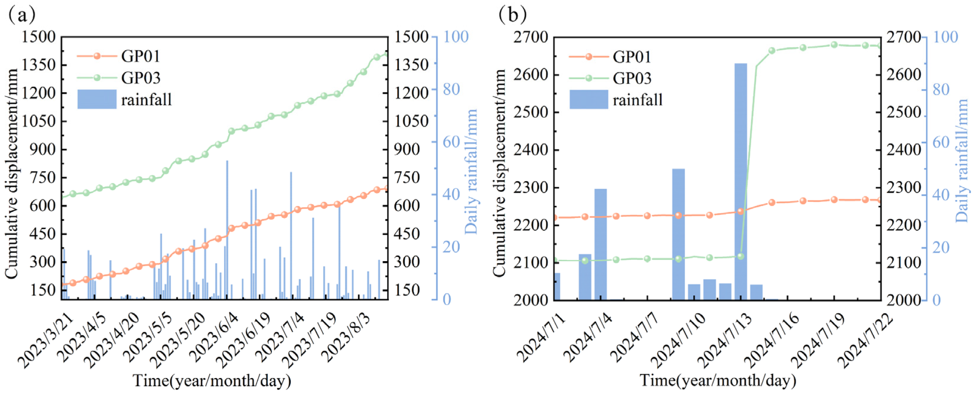
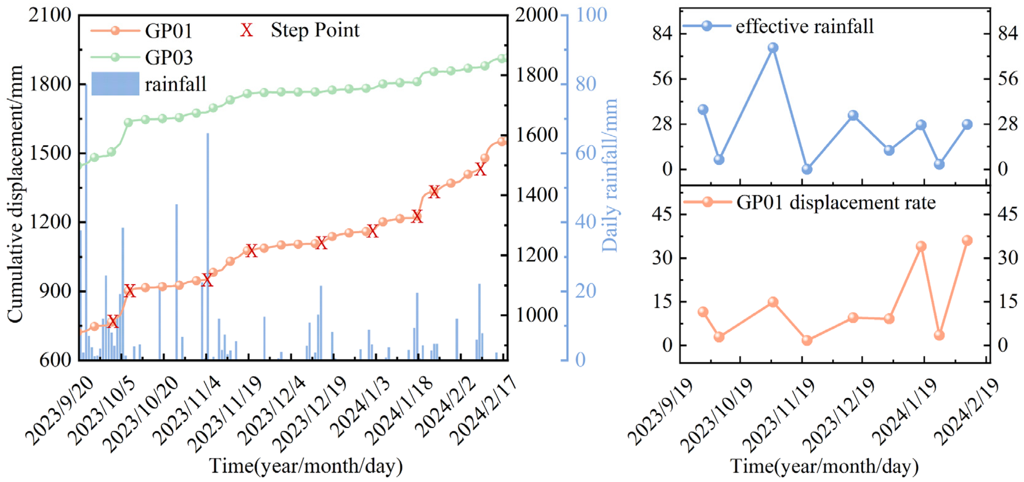
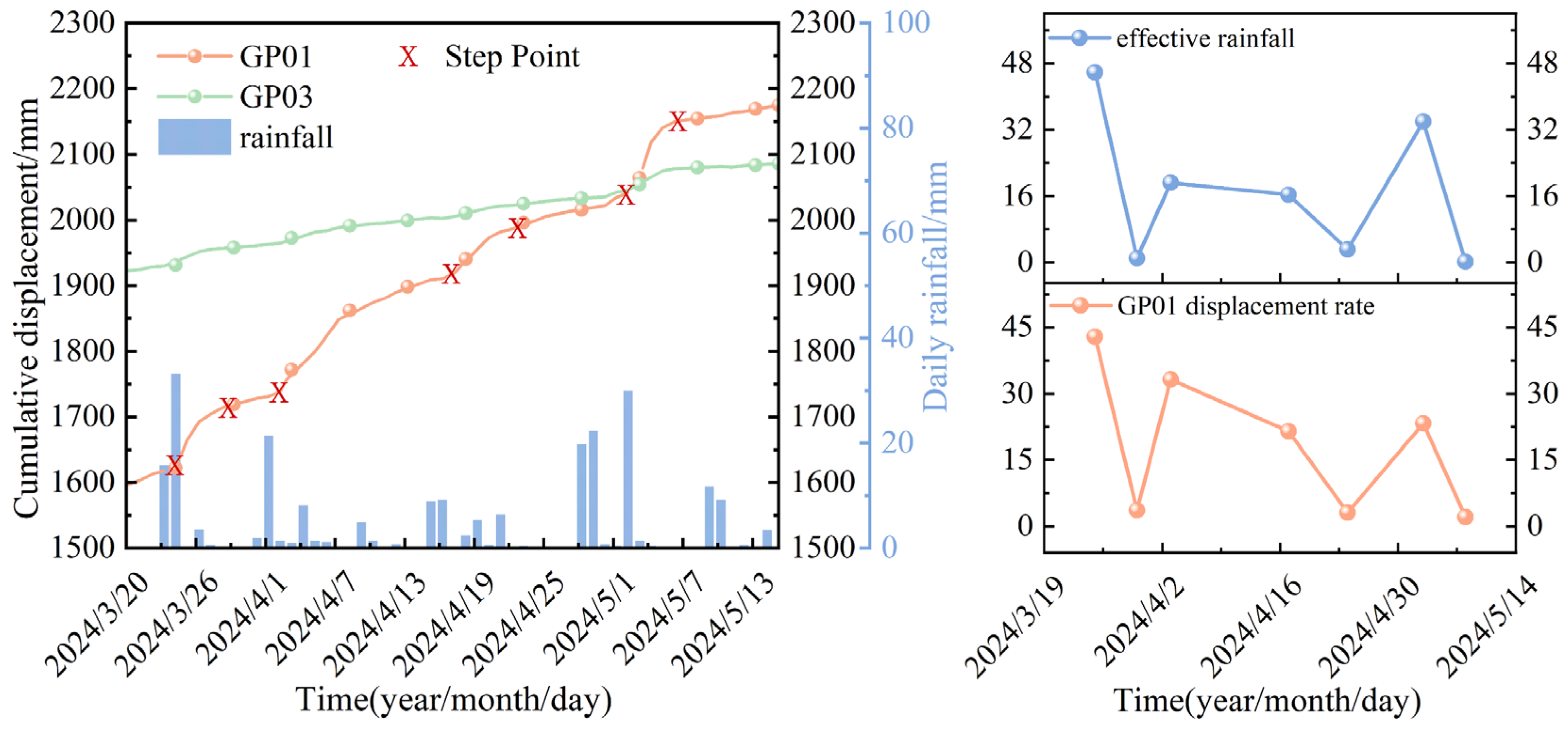
2.4. Ground Deformation Monitoring

As of 22 July 2024, the cumulative horizontal displacements at monitoring points GP01 and GP03, situated at the rear edge of the Baiyansizu landslide, were measured at 2273 mm and 2677 mm, respectively. In contrast, the displacement recorded at the front edge monitoring point GP02 was only 20 mm (Figure 2). These data indicate that the displacements at the trailing edge monitoring points (GP01 and GP03) are significantly greater than those at the front edge monitoring point (GP02), suggesting that landslide deformation is characterized by spatial concentration at the rear edge and stability at the front edge. Consequently, subsequent analyses will focus on the deformation mechanisms at the rear edge. By examining the displacement rates, the deformation processes at GP01 and GP03 can be described as an intermittent creep mode, alternating between phases of significant deformation (stages a, c, e, g, and i) and slow deformation (stages b, d, f, and h), with displacement fluctuations exhibiting strong correlations with rainfall intensity (Figure 3).
According to the data presented in Table 1, the displacement rates of GP03 during stage c (March–August 2023) and stage i (July 2024) were recorded at 5.1 mm/day and 56 mm/day, respectively. This observation reveals two distinct deformation mechanisms: during stage c, a progressive creep was triggered by long-term rainfall, which totaled 803.5 mm with a daily average of 5.4 mm. In contrast, during stage i, an abrupt step-like deformation was instigated by a single-day heavy rainfall event of 90 mm (Figure 4). Comparative analysis indicates that critical differences in landslide response arise from varying rainfall patterns: prolonged moderate to heavy rainfall contributes to cumulative deformation by infiltration-induced softening, whereas extreme rainstorms lead to pore pressure surges, thereby triggering instantaneous instability. Furthermore, during stage e, the displacement rate of GP03 decreased significantly to 3.1 mm/day, suggesting that prior large deformations may have facilitated local stress release, allowing the slope to enter a phase of self-stabilization.
Based on the Crozier effective rainfall model, rainfall is categorized into antecedent rainfall and current rainfall patterns. The calculation formula is as follows:
R c = R 0 + a R 1 + a 2 R 2 + a 3 R 3 + + a t R t
This study utilized rainfall data from the preceding five days to calculate the attenuation effect and analyze the lagged response of landslide deformation. The attenuation coefficient, as described by Huang et al. [29], can be calculated using the following formula:
a t = e t 4.34
In the formula, R c is the total effective rainfall (mm); R 0 is the daily rainfall (mm); R t is the cumulative rainfall of the preceding t days (mm); a is the attenuation coefficient.
Monitoring data reveal a significant positive correlation between the deformation rates of GP01 and GP03 and effective rainfall. The cumulative deformation effect of prolonged rainfall on the landslide is particularly pronounced (Figure 5). For instance, during phase a (Figure 6), intermittent continuous rainfall occurred from 29 April to 20 August 2022, resulting in a multi-step deformation curve for GP03. The effective rainfall amounts corresponding to its five step points ranged from 20 to 42 mm per day, while the displacement rate varied between 9.5 and 42.5 mm per day; the first step exhibited a higher rate due to initial monitoring interference. In phase e, GP03 underwent self-adaptive adjustment phase in the geotechnical mass due to accumulated deformation from earlier stages, leading to a decrease in the daily displacement rate to 3.1 mm/day (Figure 7). A similar rainfall response pattern was observed in GP01, where the effective rainfall amounts corresponding to the six step points ranged from 12 to 75 mm/d, and the displacement rate varied between 9.1 and 36.1 mm/d. The four steps in phase g further emphasize the sensitivity to rainfall (Figure 8), with effective rainfall amounts ranging from 16 to 46 mm/d and the corresponding displacement varying from 21.5 to 42.9 mm/d.
The spatiotemporal variability of landslide displacement is intricately linked to rainfall patterns. During prolonged rainfall phases (a, c), continuous long-term precipitation triggered cumulative seepage effects, resulting in step-like progressive deformation in GP03. The displacement rate was modulated by rainfall fluctuations during phase a; however, in phase c, the rate decelerated due to the stabilization of hydraulic pathways. In the short-term rainstorm phase (i), extreme rainfall events (90 mm/day) led to a sharp step-like increase in the displacement rate of GP03 (505.6 mm/day), underscoring the short-term impact of rainstorm-induced disasters. During the adjustment phases (e, g), GP03 entered a low-rate adjustment period in phase e due to stress redistribution. Conversely, in phase g, the displacement response amplitude of GP01 intensified, indicating an increased sensitivity of localized areas of the landslide to rainfall, with stability significantly weakening as effective rainfall increased.
In summary, the deformation of the trailing edge of the Baiyansizu landslide is driven by both rainfall patterns and spatiotemporal heterogeneity. Effective rainfall exerts a dual regulatory mechanism on landslide deformation: (1) long-term rainfall reduces shear strength through continuous infiltration, triggering progressive creep characterized by step-like displacements, with displacement rates positively correlated with rainfall intensity; (2) short-term rainstorms induce step-like instability through instantaneous surges in pore water pressure, leading to significant increases in displacement rates. This highlights the critical need for disaster warnings during extreme weather events. Additionally, the deformation adaptability in localized areas (e.g., stage e) suggests the existence of a dynamic stress adjustment mechanism within the landslide body. The differing responses at various monitoring points (with GP01 exhibiting higher strain-rate sensitivity compared to GP03) reflect the spatial heterogeneity of the hydro-mechanical field within the landslide. These findings provide a theoretical foundation for hierarchical early warning systems for landslides based on rainfall thresholds.

3. Landslide Numerical Simulation

3.1. Goals of Numerical Experiments Using GeoStudio

This study constructed a hydro-mechanical coupling model of the Baiyansizu landslide using GeoStudio software. The primary objective was to analyze the deformation mechanisms of the landslide under the combined influence of various factors through finite element simulation. This research specifically investigates the synergistic effects of rainfall infiltration, crack propagation, and cyclic loading, validating their interrelations and cascade response patterns in triggering landslide deformation. Furthermore, it aims to provide a quantitative framework for early warning systems concerning landslide disasters under multi-field coupling effects.

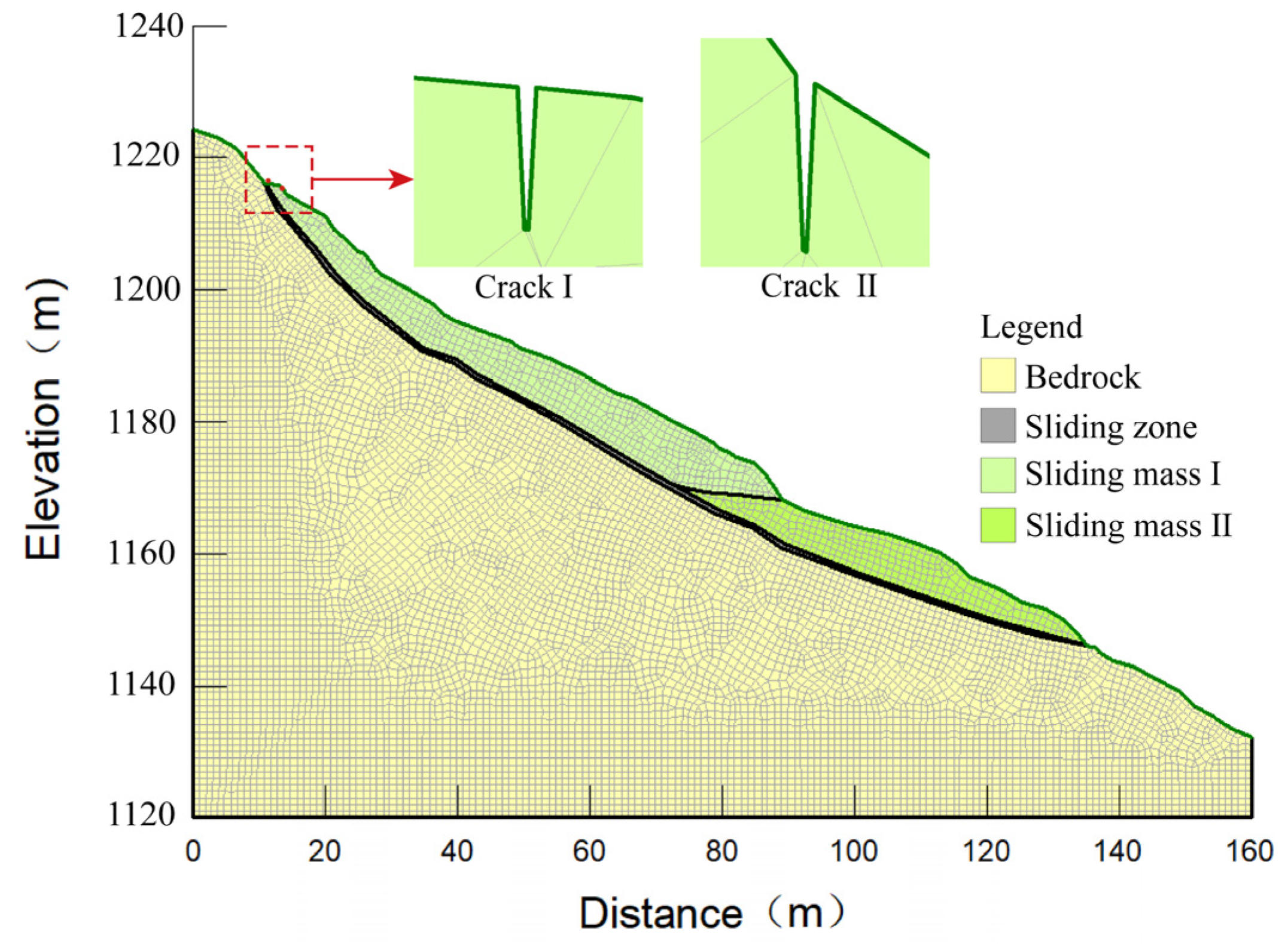
3.2. Implementation of Numerical Model

The model is categorized into four layers based on stratigraphic characteristics: sliding mass I, sliding mass II, the sliding zone, and the bedrock (Figure 9). It is discretized into 8484 elements, each with a unit size of 1 m. The boundary conditions are established in accordance with geological and hydrological characteristics. Specifically, the trailing edge on the left side of the model employs a water head height boundary [30], while the bottom is subjected to X-Y directional displacement constraints, and both sides are restricted in the X direction (detailed parameters are provided in Table 2). Under initial conditions, the model achieves a state of stress equilibrium when subjected solely to gravity. To systematically analyze the differential impacts of fissures and dynamic loads, we established two comparative models: one containing fissures and the other free of fissures [31]. The fissures had a depth of approximately 1 m. According to the “General Specifications for Design of Highway Bridges and Culverts” [32], the density of road base or fill materials can be treated as a volumetric force; thus, the periodic dynamic load was set at 20 KN/m3 during the calculation process. Furthermore, the multi-factor coupling effects were simulated based on the four types of working conditions outlined in Table 3.

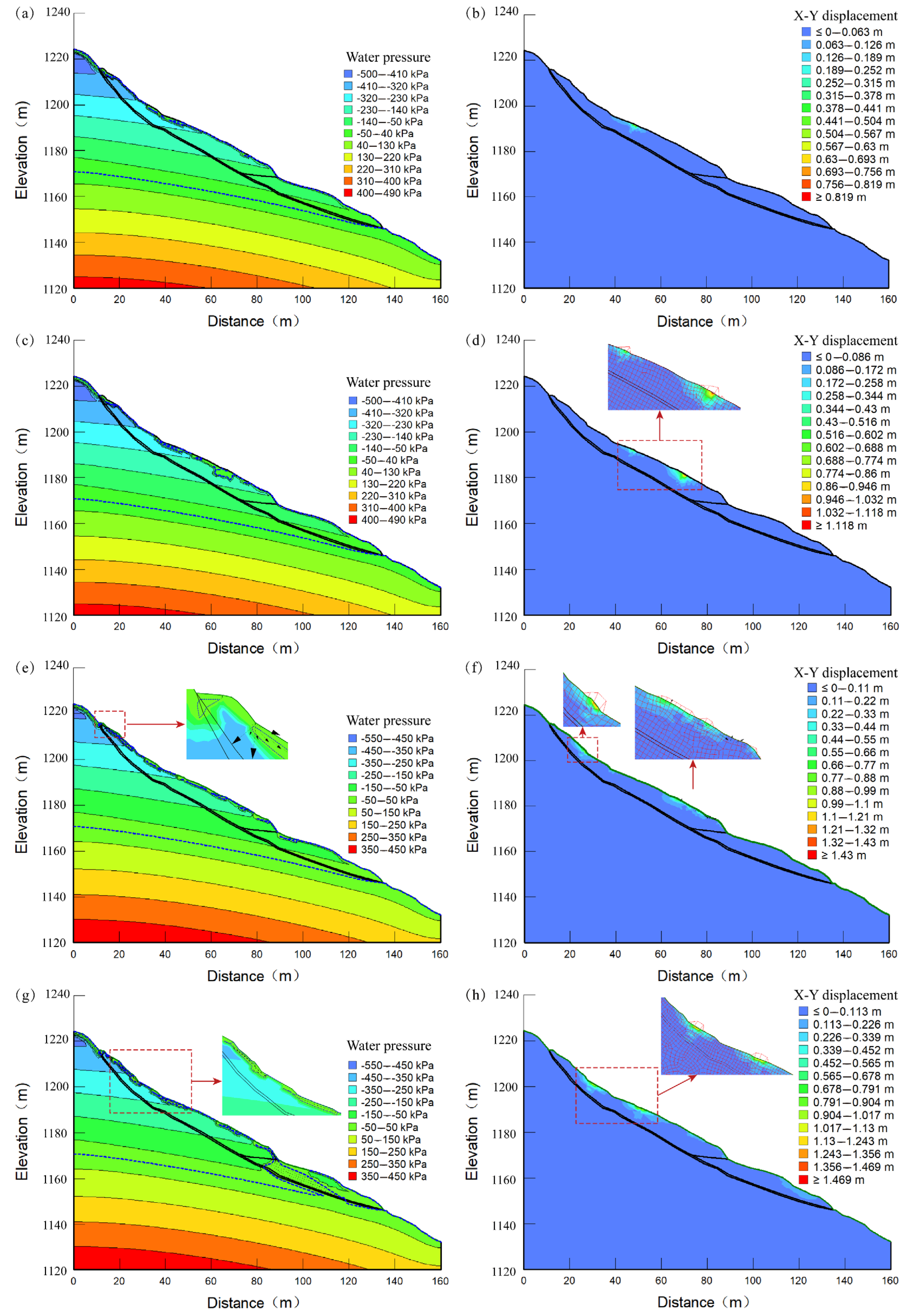
3.3. Simulation Results and Analysis

The variation in pore water pressure effectively reflects changes in groundwater levels. Under rainfall conditions, the high permeability of the shallow colluvium on the slope, combined with the presence of fissures at the trailing edge, facilitates the rapid infiltration of rainwater to the bedrock interface, thereby forming a saturated zone. As fissures develop, the water pressure on the slope surface continues to rise, indicating a transition of the slope from an unsaturated to a saturated state. This transition is characterized by a decrease in matric suction and an increase in the phreatic surface, which contributes to the continuous expansion of the saturated zone. When fissures are not considered, the water pressure in the slope increases longitudinally downward, primarily influenced by groundwater. However, when fissures are taken into account, rainfall infiltration first impacts the slope surface, generating preferential flow paths at the trailing edge. Under conditions of increased load at the trailing edge, the rainfall vector arrow rapidly extends deeper, resulting in an increase in pore water pressure, while the groundwater infiltration line rises at the front slope toe, as shown in Figure 10. Therefore, under identical rainfall conditions, the development of fissures and the application of load accelerate the saturation of the slope, leading to a more rapid reduction in matric suction and greater variation in pore water pressure.
To investigate the combined effects of rainfall, fissures, and load applications on the stability of the Baiyansizu landslide, we utilized seepage calculation results to analyze changes in the stress–strain outcomes of the landslide. This analysis revealed that the most significant displacement occurred in the upper middle part of the slope. Under the sole influence of heavy rainfall, the maximum displacement of the landslide exhibited an increasing trend. Furthermore, the development of fissures and the application of trailing edge loads further amplified this effect. Specifically, without considering the development of fissures, heavy rainfall increased the displacement to 0.82 m, while the application of road and cyclic dynamic loading escalated the displacement to 1.14 m. When accounting for the development of fissures, the displacement caused by heavy rainfall significantly increased to 1.425 m. Notably, under the combined effect of rainfall, fissures, and cyclic dynamic loading, the maximum displacement of the slope reached 1.45 m. The analysis results indicate that the presence of fissures significantly exacerbates the impact of rainfall on landslide stability, while the application of road and cyclic dynamic loading further deteriorates the situation. The combined action of these three factors leads to a substantial increase in landslide displacement, posing a serious threat to landslide stability.
The variation in the landslide stability coefficients under different conditions is illustrated in Figure 11. Under natural conditions, the stability coefficient of the landslide is relatively high, remaining close to 1.1, which indicates that the landslide is in a stable state. However, when considering factors such as rainfall and cyclic dynamic loading, the stability coefficient begins to change. In Condition I, which involves rainfall without accounting for crack development, the stability coefficient decreases from an initial value of 1.09 to 1.085 by the sixth day. Although this decrease is minor, it indicates that rainfall alone has a limited impact on landslide stability. In Condition II (adding road and periodic loading), the coefficient further drops to 1.078. This indicates that road and periodic dynamic loading exacerbate the instability of the landslide, although the overall reduction remains manageable. In Condition III (rainfall with crack development), the coefficient decreases more sharply to 1.079 on the sixth day compared to Condition I. This suggests that crack development significantly enhances the impact of rainfall on landslide stability. In Condition VI, where all factors are coupled, the coefficient significantly decreases from 1.085 to 0.995. This decline brings the value below the stability threshold, thereby indicating a heightened risk of instability.
In summary, the stability of the Baiyansizu landslide is nonlinearly influenced by multi-field coupling effects: (1) The fissures at the trailing edge significantly enhance rainfall infiltration efficiency, increasing the saturation rate of the sliding zone and constituting the dominant factor for deformation. (2) Cyclic dynamic loading accelerates the connection of the plastic zone within the sliding zone through stress redistribution, leading to an amplification of displacement accumulation effects. (3) Under the influence of multiple factors, the stability coefficient exceeds the critical threshold (Fs < 1.0), causing the landslide to enter the accelerated creep stage.

4. Discussion

Geological structures and geomechanical properties govern landslide formation and evolution [33,34]. During shallow landslide fracture development, external loads propagate cracks, creating preferential seepage paths that destabilize slopes (Figure 12). Five representative soil landslides were analyzed: Baiyansizu, Tanjiawan, Bazimen, Tudiling, and Chengnan. This research investigated multi-field coupling mechanisms (rainfall–fracture–road load interactions) using comparative case studies (Table 4).

4.1. The Impact of Rainfall Infiltration on Landslides

Rainfall is a critical factor that triggers landslide deformation. The infiltration of rainwater modifies the water content and mechanical properties of the soil, thereby increasing the likelihood of landslides [37,38]. In the context of soil landslides, the mechanisms by which rainfall impacts the soil vary with different soil thicknesses; additionally, the thickness of the landslide mass significantly influences the spatial and temporal effects of rainfall.
Specifically, shallow landslides have simple structures with near-surface sliding surfaces and thin masses. This configuration results in a more rapid and significant response to rainfall, as well as longer durations of deformation. These systems show a strong coupling between “rainfall intensity and displacement rate”, with failure thresholds governed by transient surface soil saturation (Figure 13). The multiple deformation events of the Baiyansizu landslide effectively illustrate this phenomenon, with five deformation events occurring within just two years; three of these events lasted over three months, thereby underscoring the considerable impact of rainfall on shallow landslides. The long-term rainfall pattern induces prolonged continuous deformation (a, c), while heavy rain leads to step-like deformation at a faster rate (i). Similar phenomena are also observed in the Tudiling and Chengnan landslides. Monitoring data (Figure 12) indicate that the Tudiling landslide began to exhibit step-like deformation on 8 July 2021, coinciding with daily rainfall of 58.7 mm and effective rainfall of 106.4 mm on that day. The displacement rate increased from 0.2–1.1 mm/day to 3.6–7.9 mm/day, and this deformation persisted for nearly a month. During the second rainy season from June 2007 to June 2008, the Chengnan landslide experienced extreme rainfall, with the highest recorded rainfall in July reaching 240 mm, significantly exceeding local average precipitation records. During this period, the surface deformation increment at point P4 of the landslide in the southern part of the city was 730 mm, with a cumulative displacement of up to 850 mm. At point P18, the surface deformation increment was 240 mm, with a cumulative displacement reaching 300 mm. This clearly demonstrates the immediate and intense impact of heavy rainfall on landslide deformation.
In contrast, thick-layer landslides (such as the Bazimen and Tanjiawan landslides) exhibit considerable depth and complex internal structures, which result in a prolonged duration for rainfall to infiltrate deeper layers. Consequently, the direct impact of rainfall on these landslides is relatively minor. However, rainfall can still indirectly influence landslide stability by altering groundwater dynamics and generating hydrodynamic pressure. For instance, the Tanjiawan landslide experienced three significant deformations between August 2016 and August 2020. The first step-like displacement occurred in November 2017, with a cumulative displacement increasing by 5–42 mm compared to the previous month, during which the cumulative rainfall was 12.8 mm (prior month: 303.6 mm). The second step occurred in July 2018, with cumulative displacement increasing from 85.8 to 827.8 mm compared to the previous month, during which the cumulative rainfall was 114.2 mm, while the cumulative rainfall of the prior month was 231.6 mm. The third step took place in May 2020, with cumulative displacement increasing from 12 to 144.6 mm compared to the previous month, during which the cumulative rainfall was 76.8 mm, while the cumulative rainfall of the prior month was 122.6 mm. The Bazimen landslide experienced five deformation events between May 2016 and May 2020. The first event occurred on 3 June 2016, characterized by a daily rainfall of 0.1 mm and an effective rainfall of 45.5 mm, during which the displacement rate increased from 3.0–3.6 mm/day to 8.4–12.5 mm/day. The second event took place on 10 April 2017, with a daily rainfall of 27.4 mm and an effective rainfall of 33.3 mm, resulting in an increase in the displacement rate from 0.7–0.9 mm/day to 2.4–5.5 mm/day. The third event occurred on 4 October 2017, with a daily rainfall of 16.4 mm and an effective rainfall of 51.8 mm, leading to an increase in the displacement rate from 1.5–4.5 mm/day to 13.7–20.5 mm/day. The subsequent two events exhibited a similar pattern. Deformation in thick-layer landslides is correlated not only with daily rainfall but also with preceding events, indicating time lags and energy accumulation.
In summary, rainfall exerts distinct impact mechanisms on landslides that vary with soil thickness; however, all mechanisms are closely linked to the rate of landslide deformation and the increments in displacement. To effectively prevent and control landslides, it is essential to thoroughly consider the influence of rainfall infiltration. Targeted measures should be implemented based on the specific types and characteristics of the landslides to mitigate associated risks. For deep-seated landslides, it is important to focus on groundwater dynamics and the changes in hydrodynamic pressure. Conversely, for shallow landslides, heightened vigilance is required regarding the reduction in shear strength of the geotechnical mass, as well as the acceleration of deformation induced by rainfall.

4.2. The Control of Crack Conditions on the Evolution of Shallow Landslides

Crack development critically governs shallow landslide deformation and evolution [39]. Shallow landslides, with thinner sliding masses and denser crack networks (e.g., Baiyansizu and Tudiling cases), exhibit heightened rainfall sensitivity compared to deep-seated counterparts. Their interconnected cracks facilitate rapid water infiltration to slip surfaces, forming preferential flow paths (Figure 13). For instance, the width of the rear edge cracks in the Baiyansizu landslide ranges from 1 to 20 cm, allowing rainwater to directly soften the sliding zone soil along the cracks, which in turn leads to accelerated local deformation. The Chengnan landslide’s 100 m long annular cracks caused 20 cm vertical displacement, demonstrating crack-enhanced infiltration. In contrast, the cracks in thick landslides, like Bazimen, resist full-depth crack penetration due to greater thickness and intact structures, delaying hydrological responses and reducing deformation rates. This contrast highlights shallow landslides’ spatial susceptibility to rainfall through connected fracture networks.
Shallow landslides exhibit self-reinforcing crack–deformation coupling. Their loose structures (notably in loess) enable dual degradation mechanisms: pore pressure rise reduces effective stress, while water-softening diminishes shear strength. Taking the Tudiling landslide as an example, during a 14-year continuous deformation process, crack propagation and road surface damage developed synchronously, indicating a positive feedback loop between the attenuation of geotechnical strength and the intensification of deformation. Conversely, deep-seated landslides, like Tanjiawan, resist systemic failure due to thick, dense sliding masses that confine infiltration-induced weakening to surface layers. Shallow systems’ “infiltration–softening–cracking” chain reactions (evident in Chengnan’s crack–displacement coupling) contrast with deep landslides’ self-weight compaction buffering, yielding gradual deformation. This contrast highlights the high sensitivity of shallow landslides to crack development and the irreversible nature of their instability mechanisms.

4.3. Road Load Promotes the Deformation of Shallow Landslides

Road and cyclic dynamic loads (e.g., traffic vibrations) drive shallow landslide deformation through two mechanisms: (1) stress amplification and (2) crack propagation [40,41]. In shallow landslides, like Baiyansizu and Tudiling, static loads rapidly convert vertical pressure into shear stress along thin sliding zones (<10 m thick), exceeding loess’s low shear strength thresholds to induce localized failure (Figure 13). Prolonged loading caused Tudiling’s road surface damage, whereas Bazimen’s deep-seated landslide only developed surface deformation under equivalent loads. Cyclic dynamic loading disproportionately affects shallow systems: vibrations propagate through loose soils, cyclically opening cracks (e.g., Chengnan’s rear-edge crack dilation) and inducing particle rearrangement. The metastable structure of loess accelerates dynamic degradation, initiating a chain reaction characterized by crack propagation, enhanced permeability, and intensified deformation.
In contrast, thick-layer landslides, like Tanjiawan, exhibit dampened load responses due to thick, structurally intact masses. Static load-induced shear stresses dissipate within deep strata, failing to reach slip surfaces, while dynamic energy attenuates through thick strata, inhibiting crack growth. In Tanjiawan, despite road loading, self-weight consolidation prevents preferential flow formation. This contrast underscores shallow landslides’ acute load sensitivity: thin-layer sliding masses face direct risks of shear stress exceeding strength thresholds under coupled static–dynamic loads, as observed in the Baiyansizu landslide, while also accelerating overall instability due to dynamic damage accumulation. In contrast, thick-layer landslides mitigate the destructive effects of loads through their structural advantages.
In summary, road load and its accompanying cyclic dynamic load significantly promote the deformation process of shallow landslides. The increase in road load intensifies stress concentration within the landslide mass, while the cyclic dynamic load facilitates crack expansion and soil densification, collectively accelerating the deformation process of the landslide. In contrast, thick-layer landslides, due to their greater thickness of the sliding mass, are relatively less affected by road load and exhibit more stable deformation characteristics.

5. Conclusions

This study examines the deformation characteristics and mechanisms of the Bai-yansizu landslide under the coupled effects of crack development, rainfall infiltration, and road loading. The interaction between rainfall patterns and external disturbances creates significant nonlinear synergistic effects, intensifying landslide deformation. Using the GeoStudio numerical simulation platform, we constructed scenarios comparing single-factor, dual-factor, and multi-factor coupling effects to quantitatively assess how these factors drive deformation evolution. Additionally, we conducted a comparative analysis of the Tanjiawan, Bazimen, Tudiling, and Chengnan landslides, exploring why deformation characteristics and mechanisms differ among landslides of varying thicknesses under external disturbances. A summary of the findings of this research is presented below:
  • The deformation at the trailing edge of the Baiyansizu landslide is primarily influenced by rainfall patterns. Effective rainfall exerts a dual regulatory mechanism on landslide deformation: long-term rainfall diminishes shear strength through continuous infiltration, resulting in progressive creep, while short-term heavy rainfall induces step-like deformation due to instantaneous surges in pore water pressure. This underscores the significance of early warning systems for extreme weather events.
  • GeoStudio numerical simulations indicate that the stability of the Baiyansizu landslide is influenced by multi-field coupled nonlinearities. The fissures at the trailing edge significantly enhance the efficiency of rainfall infiltration, becoming the primary factor contributing to deformation. Cyclic dynamic loading expedites the penetration of the plastic zone within the sliding belt, thereby amplifying the displacement accumulation. When the stability coefficient exceeds the critical value, the landslide experiences accelerated creep. Additionally, road loads and their associated cyclic dynamic loading facilitate the expansion of fissures and the densification of the soil, collectively accelerating the deformation process of the shallow landslide.
  • A comparative analysis of five typical landslide cases reveals the significant influence of geological factors on external disturbances. Variations in landslide thickness, crack development, road load, and rainfall infiltration contribute to differing deformation characteristics and mechanisms. In landslide prevention and control efforts, the impact of rainfall infiltration must be thoroughly considered, and targeted measures should be implemented based on the specific types and characteristics of each landslide.

Author Contributions

Formal analysis, P.F. and B.W.; Investigation, L.L.; Resources, Q.Y.; Data curation, Y.S.; Writing—original draft, P.F. and B.W.; Funding acquisition, Q.Y. and M.D. All authors have read and agreed to the published version of the manuscript.

Funding

This research was funded by [Hubei Yangtze River Three Gorges Landslide National Field Scientific Observation and Research Station], [China Three Gorges University], [National Natural Science Foundation of China] grant number [No. 42172303].

Data Availability Statement

Data are contained within the article.

Acknowledgments

The authors appreciate the editor and anonymous referees for their suggestions and comments, which have significantly improved the quality of the manuscript.

Conflicts of Interest

The authors declare that they have no known competing financial interests or personal relationships that could have appeared to influence the work reported in this paper.

References

  1. Mondini, A.C.; Guzzetti, F.; Melillo, M. Deep learning forecast of rainfall-induced shallow landslides. Nat. Commun. 2023, 14, 2466. [Google Scholar] [CrossRef] [PubMed]
  2. Fan, L.; Lehmann, P.; Zheng, C.; Or, D. Rainfall Intensity Temporal Patterns Affect Shallow Landslide Triggering and Hazard Evolution. Geophys. Res. Lett. 2020, 47, e2019GL085994. [Google Scholar] [CrossRef]
  3. Li, W.; Liu, C.; Scaioni, M.; Sun, W.; Chen, Y.; Yao, D.; Chen, S.; Hong, Y.; Zhang, K.; Cheng, G. Spatio-temporal analysis and simulation on shallow rainfall-induced landslides in China using landslide susceptibility dynamics and rainfall I-D thresholds. Sci. China Earth Sci. 2017, 60, 720–732. [Google Scholar] [CrossRef]
  4. Lee, J.-H.; Kim, H.; Park, H.-J.; Heo, J.-H. Temporal prediction modeling for rainfall-induced shallow landslide hazards using extreme value distribution. Landslides 2021, 18, 321–338. [Google Scholar] [CrossRef]
  5. La Porta, G.; Leonardi, A.; Pirulli, M.; Cafaro, F.; Castelli, F. Time-resolved triggering and runout analysis of rainfall-induced shallow landslides. Acta Geotech. 2024, 19, 1873–1889. [Google Scholar] [CrossRef]
  6. Wu, Z.; Ye, R.; Yang, S.; Wen, T.; Huang, J.; Chen, Y. Study on Early Identification of Rainfall-Induced Accumulation Landslide Hazards in the Three Gorges Reservoir Area. Remote Sens. 2024, 16, 1669. [Google Scholar] [CrossRef]
  7. Li, W.C.; Dai, F.C.; Wei, Y.Q.; Wang, M.L.; Min, H.; Lee, L.M. Implication of subsurface flow on rainfall-induced landslide: A case study. Landslides 2015, 13, 1109–1123. [Google Scholar] [CrossRef]
  8. Zhuang, Y.; Xing, A.; Sun, Q.; Jiang, Y. Insights into initiation of typhoon-induced deep-seated landslides in Southeast coastal China. Nat. Hazards 2023, 119, 721–749. [Google Scholar] [CrossRef]
  9. Wen, H.; Xiao, J.; Wang, X.; Xiang, X.; Zhou, X. Analysis of Soil–Water Characteristics and Stability Evolution of Rainfall-Induced Landslide: A Case of the Siwan Village Landslide. Forests 2023, 14, 808. [Google Scholar] [CrossRef]
  10. Tsai, T.-L. Influences of soil water characteristic curve on rainfall-induced shallow landslides. Environ. Earth Sci. 2011, 64, 449–459. [Google Scholar] [CrossRef]
  11. Balzano, B.; Tarantino, A.; Ridley, A. Preliminary analysis on the impacts of the rhizosphere on occurrence of rainfall-induced shallow landslides. Landslides 2019, 16, 1885–1901. [Google Scholar] [CrossRef]
  12. Wu, T.; Li, H.-C.; Wei, S.-P.; Chen, W.-B.; Chen, Y.-M.; Su, Y.-F.; Liu, J.-J.; Shih, H.-J. A comprehensive disaster impact assessment of extreme rainfall events under climate change: A case study in Zheng-wen river basin, Taiwan. Environ. Earth Sci. 2016, 75, 597. [Google Scholar] [CrossRef]
  13. Ali, A.; Huang, J.; Lyamin, A.; Sloan, S.; Cassidy, M. Boundary effects of rainfall-induced landslides. Comput. Geotech. 2014, 61, 341–354. [Google Scholar] [CrossRef]
  14. Lai, Q.; Zhao, J.; Shi, B.; Liu, H.; Ji, L.; Li, Q.; Huang, R. Deformation evolution of landslides induced by coal mining in mountainous areas: Case study of the Madaling landslide, Guizhou, China. Landslides 2023, 20, 2003–2016. [Google Scholar] [CrossRef]
  15. Liu, Z.; Liang, C.; Sens-Schönfelder, C.; Hu, W.; Sun, X.; Zhang, T.; Xu, R.; Jiang, Z.; Jiang, H. Monitoring crack opening via seismic velocity variation to assess that fatal effect of precipitation for landslide motion. Earth Planet. Sci. Lett. 2024, 644, 118922. [Google Scholar] [CrossRef]
  16. Miao, M.; Tang, H.; Fang, K.; Jiang, Y.; Li, C.; Lv, B. Influence of tensile crack development on the deformation behavior and failure mode of reservoir-induced landslides: Insights from model tests. Landslides 2025. Advance online publication. [Google Scholar] [CrossRef]
  17. Sepúlveda, S.A.; Petley, D.N.; Brain, M.J.; Tunstall, N. The effect of dynamic loading on the shear strength of pyroclastic Ash Deposits and implications for landslide hazard: The case of Pudahuel Ignimbrite, Chile. Eng. Geol. 2016, 205, 54–61. [Google Scholar] [CrossRef]
  18. Paronuzzi, P.; Bolla, A. In-depth field survey of a rockslide detachment surface to recognise the occurrence of gravity-induced cracking. Eng. Geol. 2022, 302, 106636. [Google Scholar] [CrossRef]
  19. Chen, G.; Li, P.; Leng, Z.; Wu, T.; Li, C.; Xiang, J.; Liu, Y.; Huo, P. Transient model of unsteady creep of sliding zone soil under cyclic dynamic load based on fractional derivative. Alex. Eng. J. 2023, 83, 212–221. [Google Scholar] [CrossRef]
  20. Luo, Y.; Zhang, J.; Zhou, Z.; Jiang, G.; Duan, M. Effects of improper emergency mitigations on a large-scale landslide triggered by road excavation: A case study of the Fengping landslide, Hubei province, China. Bull. Eng. Geol. Environ. 2024, 83, 258. [Google Scholar] [CrossRef]
  21. Yang, X.; Chen, Y. Characteristics and mechanism of landslides on highway landfill along Xiaolangdi Reservoir of the Yellow River: A case study. Nat. Hazards 2024, 120, 10321–10343. [Google Scholar] [CrossRef]
  22. Sun, S.; Jiang, Z.; Li, L.; Qiu, D. Model test and numerical verification of surrounding rock stability of super-large-span and variable-section tunnels. Tunn. Undergr. Space Technol. 2024, 153, 106020. [Google Scholar] [CrossRef]
  23. Huang, F.; Chen, J.; Liu, W.; Huang, J.; Hong, H.; Chen, W. Regional rainfall-induced landslide hazard warning based on landslide susceptibility mapping and a critical rainfall threshold. Geomorphology 2022, 408, 108236. [Google Scholar] [CrossRef]
  24. Zhang, G.; Wang, R.; Qian, J.; Zhang, J.-M.; Qian, J. Effect study of cracks on behavior of soil slope under rainfall conditions. Soils Found. 2012, 52, 634–643. [Google Scholar] [CrossRef]
  25. Zhang, L.; Jiang, X.; Sun, R.; Gu, H.; Fu, Y.; Qiu, Y. Stability analysis of unsaturated soil slopes with cracks under rainfall infiltration conditions. Comput. Geotech. 2023, 165, 105907. [Google Scholar] [CrossRef]
  26. Jiao, W.; Zhang, M.; Li, P.; Xie, J.; Pang, H.; Liu, F.; Yang, L. Evolution model and failure mechanisms of rainfall-induced cracked red clay slopes: Insights from Xinshao County, China. J. Mt. Sci. 2024, 21, 509–523. [Google Scholar] [CrossRef]
  27. Gratchev, I. Insights into the mechanism of earthquake-triggered landslides in plastic fine-grained soils. Soil Dyn. Earthq. Eng. 2023, 173, 108134. [Google Scholar] [CrossRef]
  28. Liang, Z.; Xu, J.; Cao, H.; Zeng, Y.; Wu, T. Theoretical study on the mechanism of slope sliding resistance and sliding force on multi-field coupling instability. Ain Shams Eng. J. 2024, 15, 103072. [Google Scholar] [CrossRef]
  29. Huang, X.H.; Lei, D.X.; Xia, J.B.; Yi, W.; Zhang, P. Forecast analysis and application of stepwise deformation of landslide induced by rainfall. Rock Soil Mech. China 2019, 40, 3585–3592, 3602. [Google Scholar] [CrossRef]
  30. Hou, T.-S.; Xu, G.-L.; Zhang, D.-Q.; Liu, H.-Y. Stability analysis of Gongjiacun landslide in the three Gorges Reservoir area under the action of reservoir water level fluctuation and rainfall. Nat. Hazards 2022, 114, 1647–1683. [Google Scholar] [CrossRef]
  31. Wang, L.; Zhang, K.; Chen, Y.; Wang, S.; Tian, D.; Li, X.; He, Y. Progressive deformation mechanism of colluvial landslides induced by rainfall: Insights from long-term field monitoring and numerical study. Landslides 2024, 21, 3069–3086. [Google Scholar] [CrossRef]
  32. JTG D60—2004; General Code for Design of Highway Bridges and Culverts. China Communications Press: Beijing, China, 2004.
  33. Wang, B.; Zuo, Q.; Deng, M.; Yi, Q.; Ruan, D.; Liang, Z. Study on the deformation mechanism of chair-like bedding rock landslides under the coupling effect of geological and hydrological factors. Eng. Geol. 2024, 344, 107832. [Google Scholar] [CrossRef]
  34. Zhou, C.; Cao, Y.; Yin, K.; Intrieri, E.; Catani, F.; Wu, L. Characteristic comparison of seepage-driven and buoyancy-driven landslides in Three Gorges Reservoir area, China. Eng. Geol. 2022, 301, 106590. [Google Scholar] [CrossRef]
  35. Song, K.; Han, L.; Ruan, D.; Li, H.; Ma, B. Stability Prediction of Rainfall-Induced Shallow Landslides: A Case Study of Mountainous Area in China. Water 2023, 15, 2938. [Google Scholar] [CrossRef]
  36. Ren, Y.; Li, T.; Dong, S.; Tang, J.; Xue, D. Rainfall-induced reactivation mechanism of a landslide with multiple-soft layers. Landslides 2020, 17, 1269–1281. [Google Scholar] [CrossRef]
  37. Chen, G.; Bian, S.; Ma, J.; Meng, X.; Shi, W.; Wu, J.; Zhang, Y.; Li, Y. Field experiment on the spatiotemporal evolution of soil moisture in a rainfall-induced loess landslide: Implications for early warning. J. Hydrol. 2024, 630, 130777. [Google Scholar] [CrossRef]
  38. Sun, P.; Wang, G.; Wu, L.Z.; Igwe, O.; Zhu, E. Physical model experiments for shallow failure in rainfall-triggered loess slope, Northwest China. Bull. Eng. Geol. Environ. 2018, 78, 4363–4382. [Google Scholar] [CrossRef]
  39. Sun, H.-Y.; Pan, P.; Lü, Q.; Wei, Z.-L.; Xie, W.; Zhan, W. A case study of a rainfall-induced landslide involving weak interlayer and its treatment using the siphon drainage method. Bull. Eng. Geol. Environ. 2018, 78, 4063–4074. [Google Scholar] [CrossRef]
  40. Hu, W.; Hu, W.; Luo, H.; Luo, H.; Xu, Q.; Xu, Q.; McSaveney, M.; McSaveney, M.; Huang, R.; Huang, R.; et al. Effect of Amplitude and Duration of Cyclic Loading on Frictional Sliding Instability in Granular Media: Implication to Earthquake Triggering of Landslides. J. Geophys. Res. Solid Earth 2022, 127, e2022JB024488. [Google Scholar] [CrossRef]
  41. Li, S.; Wang, J.; Han, K.; Wang, L.; Zhang, D.; Dong, H.; Cui, B. Promoting effect and microscopic mechanism of train-induced vibration on loess disintegration. Eng. Geol. 2024, 336, 107559. [Google Scholar] [CrossRef]
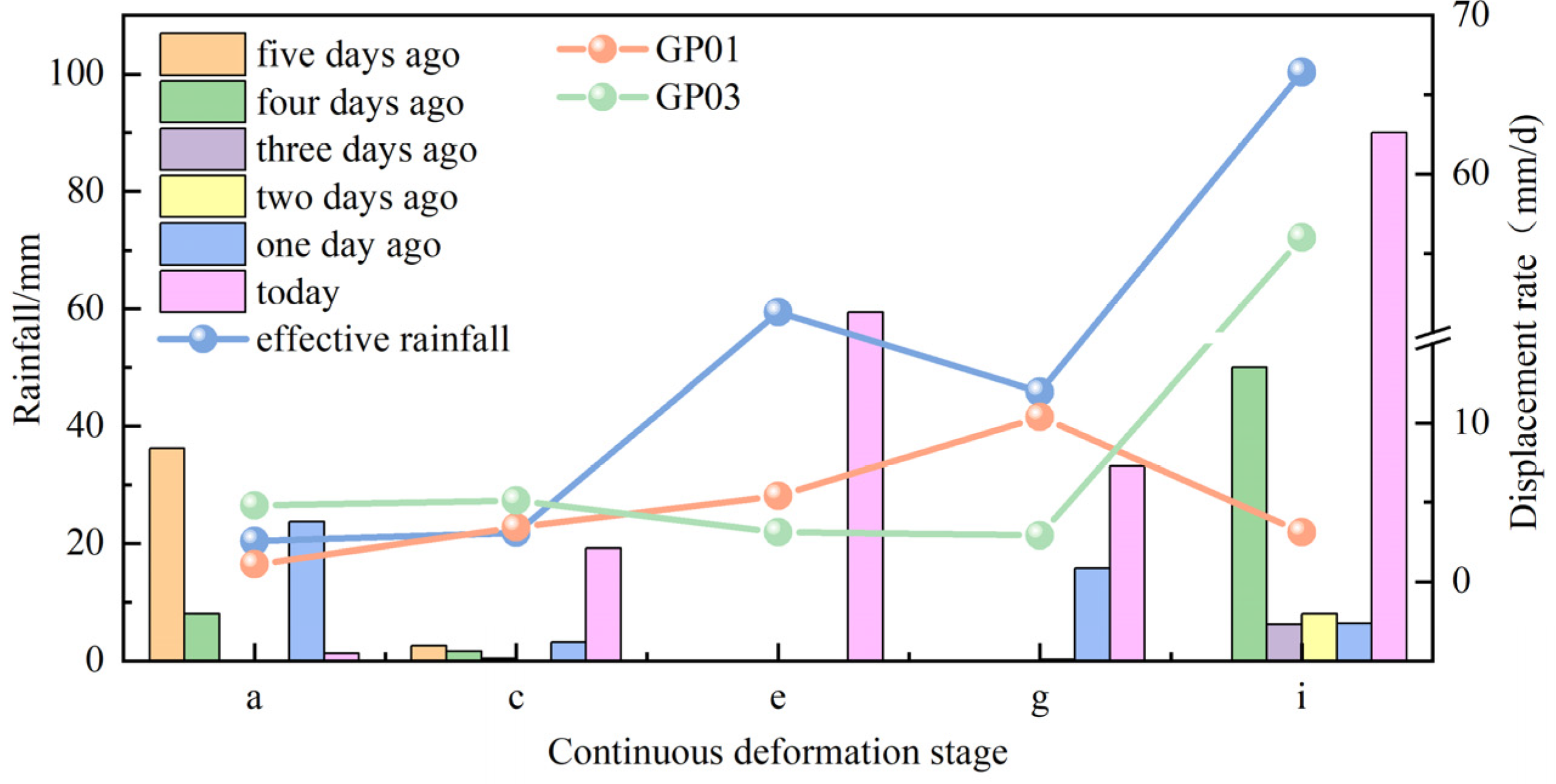
Figure 1. (a,b) The overall view of the Baiyansizu landslide; (c) the profile morphology of the Baiyansizu landslide. ①~⑥ indicate signs of landslide deformation.
Water 17 01196 g001
Figure 2. From 2022 to 2024, the daily rainfall and detection results of the monitoring points in the landslide area.
Water 17 01196 g002
Figure 3. From 2022 to 2024, the daily rainfall and daily displacement rates at the monitoring points recorded in the landslide area.
Water 17 01196 g003
Figure 4. The displacement and rainfall data for the monitoring point. Panel (a) depicts stage c, while panel (b) represents stage i.
Water 17 01196 g004
Figure 5. Monitoring point displacement and rainfall during continuous deformation phase.
Water 17 01196 g005
Figure 6. In stage a, monitor point displacement and rainfall.
Water 17 01196 g006
Figure 7. In stage e, monitor point displacement and rainfall.
Water 17 01196 g007
Figure 8. In stage g, monitor point displacement and rainfall.
Water 17 01196 g008
Figure 9. Generalized model of Baiyansizu landslides with fissures.
Water 17 01196 g009
Figure 10. The variations in seepage and displacement fields of Baiyansizu landslides. Panels (a,b) depict Condition I; panels (c,d) represent Condition II; panels (e,f) correspond to Condition III; and panels (g,h) illustrate Condition VI.
Water 17 01196 g010
Figure 11. Changes in landslide stability coefficient under 4 conditions.
Water 17 01196 g011
Figure 12. Comparative analysis of landslide deformation affected by rainfall. (a) The monitoring point displacement curve of the landslides of Tanjiawan landslide; (b) the monitoring point displacement curve of Baizimen landslide; (c) the monitoring point displacement curve of Tudiling landslide [35]; (d) the monitoring point displacement curve of Chengnan landslide [36].
Water 17 01196 g012
Figure 13. The influence of rainfall, load, and cracks on the deformation of Baiyansizu landslide. (a) Short-term rainstorms. (b) Long-term rainfall.
Water 17 01196 g013
Table 1. Information on the displacement of monitoring points, rainfall, and other related information at each stage.
StageTimeAutomatic Monitoring PointDisplacement Data (mm)Daily Average Displacement Rate (mm/Day)Accumulated Rainfall (mm)Daily Average Rainfall (mm/Day)Maximum Daily Rainfall
(mm)
Effective Rainfall (mm)
a2022/4/29–2022/8/20 GP01122.81.1471.14.153.220.4
GP03552.44.8
c2023/3/23–2023/8/17GP01510.43.4803.55.45321.8
GP03763.25.1
e2023/9/20–2024/2/19 GP01832.65.4734.84.88059.4
GP034693.1
g2024/3/25–2024/5/16 GP01552.510.4215.64.133.245.8
GP03154.62.9
i2024/7/13–2024/7/22GP0130.73.196.69.6690100.3
GP0356056
Table 2. GeoStudio numerical model parameters.
ParametersBulk Density (KN/m3)Cohesion
(kPa)
Friction
(°)
Saturated Volumetric Water Content (%)Permeability Coefficient (m/d)
Sliding mass I20.918.92229.630
Sliding mass II20.918.92229.610
Sliding zone20.5161729.40.296
Bedrock222015100.02
Table 3. GeoStudio numerical model condition setting.
Condition Design
Condition IStage e, effective rainfall
Condition IIStage e, effective rainfall, periodic dynamic load
Condition IIIStage e, effective rainfall, crack conditions
Condition VIStage e, effective rainfall, crack conditions, periodic dynamic load
Table 4. Comparison of typical shallow soil landslide characteristics.
LandslideType of LandslideCrack ConditionsSurface Loading
Baiyansizu landslideShallow landslideMultiple cracks have developed at the trailing edge of the road, presenting an arc shape and penetrating through, with widths varying from 5 to 20 cmHighways, houses, vegetation, etc.
Tudiling landslideShallow landslideMultiple cracks have developed at the trailing edge, measuring between 5 and 10 m in length and 5 to 10 cm in widthHighways, houses, vegetation, etc.
Chengnan landslideShallow landslideMultiple tensile cracks have developed, with widths ranging from 3 to 5 cm, and the annular crack at the trailing edge has expanded to a length of 100 mHighways, houses, vegetation, etc.
Tanjiawan landslideMedium-thick-layer landslideMultiple tensile cracks have developed in the middle and rear sections, measuring between 5 to 80 m in length and 4 to 30 centim in widthHighways, houses, vegetation, etc.
Bazimen landslideThick-layer landslideMultiple tensile cracks have formed beneath the front edge road, with lengths ranging from 50 to 200 m and widths varying between 1 and 15 centimHighways, houses, vegetation, etc.
Disclaimer/Publisher’s Note: The statements, opinions and data contained in all publications are solely those of the individual author(s) and contributor(s) and not of MDPI and/or the editor(s). MDPI and/or the editor(s) disclaim responsibility for any injury to people or property resulting from any ideas, methods, instructions or products referred to in the content.

