Article

Form-Based Regulations to Prevent the Loss of Urbanity of Historic Small Towns: Replicability of the Monte Carasso Case

Faculty of Architecture, Warsaw University of Technology, 00-661 Warsaw, Poland
Land 2021, 10(11), 1235; https://doi.org/10.3390/land10111235
Submission received: 6 September 2021 / Revised: 5 November 2021 / Accepted: 10 November 2021 / Published: 12 November 2021
(This article belongs to the Special Issue Contemporary Cityscape—Structure, Aesthetics, Perception)

Abstract

:
Small towns are a significant component of the landscape in Europe and a key element of its cultural heritage. Currently, they face socio-economic crisis and spatial disintegration. Against this background, the spatial transformation of the Swiss town of Monte Carasso is of particular interest. It was initiated in the 1970s as a design intervention made by the architect Luigi Snozzi and eventually constituted a local spatial policy with a scope to maintain or even restore town urbanity and identity. This paper describes the case through its decomposition into primal elements such as context, main procedure elements, supplementary action, and obtained results. The results were measured by calculating urban parameters and observations compared with the adjacent town of Sementina, whereby they proved that the policy is effective. In the next step, a synthetic diagram was proposed that describes the interrelation between specific elements of the procedure. It was then modified to serve as a model for other possible contexts. Finally, its main potentials and limitations were described. It was concluded that the construction of the Monte Carasso urban regulatory mechanism has the potential to be replicated elsewhere. However, some of its features need to be rethought—mainly the role of an individual architect, which was highly exposed in the original case.

1. Introduction

1.1. Small Towns—Context

Small towns are a substantial component of the landscape in Europe and a key element of its cultural heritage. They account for a significant fraction of the total population in Europe [1,2]. Currently, however, the vast majority of dynamic economic and cultural processes occur in larger cities [3]. This leads to semi-urban and rural areas (including small towns) facing an economic and social crisis [4]. The problem seems to be common—albeit with slight variation in its spectrum—across most regions in Europe [5,6,7,8,9] and beyond [10].
As a consequence of this socio-economic decline, the spatial aspect of small towns has also become endangered. Being deprived of their internal driving forces, they have become dependent on dominant regional centers and have slowly blended into the suburban belts of larger cities. Towns are losing their spatial integrity and identity, which manifests primarily in the decline in public space—toward becoming merely transport infrastructure—and a shift in the dominant typology of buildings, toward detached villas surrounded by gardens. Traditional zoning policy has proven to be ineffective in some contexts [11], and the need for more active “managerial” spatial policy has been raised by some scholars and practitioners [12].
Despite relatively modest interest in small towns from both academic and professional segments of society [13,14,15], several solutions were proposed as a remedy to this process, ranging from the disciplinary field of the economy (some interesting proposals include setting a limit on local market share for supermarket chains, capping the physical size of supermarkets, creating community land trusts that establish community ownership of key tracts of town center land) to urban design (improving pedestrian access, establishing exterior green spaces with more trees, consolidation of cars and parking) [1,16].
Considering this, the town of Monte Carasso is an interesting case. Its latest transformations (initiated in the 1970s by the architect Luigi Snozzi) have the character of “re-urbanization “. They are firmly based in architecture and most of the developments have been purely physical. There have been neither financial operations nor direct social programs. Nevertheless, the effects of its physical development reach beyond just the built environment and affect the life of the community. Monte Carasso shows the potential of architecture and urban design in substantially influencing society, not as a mere aesthetic add-on but as a real game changer.
As a proven method that has signs of a “finished product”, it is possible that the method itself can be disseminated and popularized. Indeed, the case has raised the interest of researchers and critics, and a number of books and papers have been written about it [17,18,19,20,21]. These materials, however, focus on the individuality of the Monte Carasso case and the specific role played in it by Luigi Snozzi himself. The procedure itself raised a smaller amount of interest. As a morphology, i.e., a form-based mechanism, it may seem conservative, earthbound, and architecture oriented. It is distant from dominant contemporary planning discourse, which is focused on “soft” activities, people involvement, and big data [22]. However, as Karl Kropf argues [23], the form of urban tissue largely determines the “character” of towns. In turn, Troger and Eberle [24] claim that urban planning parameters are responsible for the atmosphere of urban life, including social relations.

1.2. Questions and Goals

In this paper, I argue that the durability of the procedure under consideration (and its results), allows it to be a potentially effective base for spatial policy in other historic towns—regardless of specific geographic context. Thus, the two main hypotheses are as follows:
  • The spatial effects achieved in Monte Carasso can be considered better (more consistent with the place character) than in the neighboring towns;
  • The planning procedure and environment of Monte Carasso are replicable, so it is possible to create an abstract model of them, adaptable to local conditions.
This “universal” aspect seems to be underestimated; therefore, it deserves a closer examination. It is of particular importance now, as the main actor of considered transformation passed away in December 2020, whereby there is a need to save and develop his legacy. The paper aims at bringing the particular procedure to a more abstract, systemic level.
The possibility of implementing morphology—or form-based planning systems—has been analyzed, referring to both European [25,26,27], and non-European contexts [28,29,30], but their potential has still not been sufficiently explored [31]. The planning procedure of Monte Carasso was classified here as form based or morphological, despite not being referred to as such by stakeholders. In fact, it does not directly use methods from the Conzenian geographic school, nor from the typo-morphological Caniggian school [32]. However, it is primarily concerned with a form of development, which makes it formal in its basic idea.

1.3. Content

The body of the paper consists of six sections. After the introduction in Section 1, and presentation of methods in Section 2, the considered case of Monte Carasso is described—divided into three main sections. Firstly, in Section 3.1, the context is outlined, which includes geographic, socio-economic, cultural, and legal conditions, as well as the influence of an individual—architect Luigi Snozzi. Later, in Section 3.2, the basic elements of the local system are identified and described. These include regulations, codes, and procedures directly controlling spatial processes. Finally, in Section 3.3, the supporting elements are presented, which include consultation, educational, popularization, and exemplification activities that support positive spatial processes and provide their proper background. Section 4 contains a description and assessment of the spatial effects of the considered regulations. Section 5 explores the replicability potential of the Monte Carasso planning environment through its synthetic notation in the form of a diagram. In Section 6, the last section of the study, conclusions are provided.

2. Methods

This study combined both a case study and a comparative approach. Its main goal is to explore the potential of the Monte Carasso planning environment, and therefore, it primarily employed a case study method. However, to confirm the validity of the system adopted in this Swiss small town and visualize its potential, a comparative study was also included.
The role of the comparative study is secondary, limited to examining visible spatial effects. The neighboring town of Sementina, which can be considered a twin of Monte Carasso was chosen as a reference object. Both towns have a similar population area and location, which is between a mountain massif and a river belt. They are separated by the straight line of a mountain stream.
The assessment of the Monte Carasso transformation could not be accomplished as a before–after comparison because of its relatively long time span. The modernization processes that have occurred worldwide over the last 40 years have had a colossal impact on the spatial development of towns. It would be difficult to separate the effects of these processes from the consequences of Snozzi’s planning reform. A comparative element was included, therefore, to emulate the “natural history of a disease” (i.e., what could be the appearance and function of Monte Carasso if it was not for Snozzi).
The methodology adopted here was based on the analysis of the Monte Carasso urban transformation process. Its individual elements were distinguished and positioned within a scheme. The identification of its mechanics and analysis of its potential were the main outcomes of this paper.
Their assessment was made both in an objective (numerical) and descriptive manner. The objective measurement consisted of the following key urban parameters:
  • Building density within the urbanized area (as a relation of the total built-up area in the entire urbanized area);
  • Population density (as a ratio of population to the urbanized area);
  • The compactness of the town (number of buildings in a zone within a five-minute walk to the central point in relation to the total number of buildings; the focal point was designated in two variants: as the town hall and the geometric center of the urbanized area—“centroid”);
  • The scale of buildings (number of buildings with a built-up area exceeding 2000 m2/500 m2).
Data were obtained from the Open Street Map [33]. Analyses were made using QGIS software [34], with QuickOSM [35] and ORS Tools [36] plugins used for processing.
The subjective description concerned several difficult-to-measure morphological features of a small town, recognized in the literature [1,37] as typical for such settlements. These features include compactness, legible separation from the surrounding landscape, morphology dependent on topography, clear demarcation of public spaces, slow and small mobility, etc. The results were compared with the town of Sementina.
Finally, in the Discussion Section, all of the above elements are systematically ordered within the framework of a diagram reflecting the mechanics of the Monte Carasso case. Its analysis led to the identification of those features and relations of the system that have the greatest universal potential.
This study regarded small towns as those understood in terms of urbanism. The definition of such a category is very difficult given the various academic and administrative traditions across Europe [3,15]. Regional geostatistical tools have little accuracy here, due to their coarse resolution (1 km2) and rigid urban–rural dichotomy [38]. Small towns, as an intermediate level between villages and cities, escape this classification (even with having a high building/population density, they do not always reach the population threshold of 5000). In some countries, these settlements would be considered villages (due to the significant agricultural occupational tendency of inhabitants), while in others, they would be defined as towns, due to their compactness (as opposed to dispersed villages).
For the sake of this paper, small towns are understood as settlements of historical origin, initially compact in spatial character, with populations ranging from ~1000 to ~10,000 people. This definition covers three of four criteria of urbanity proposed by Wirth [39]—size, density, and permanence in time. Threshold values were chosen due to their simplicity. They corresponded to those proposed by Doxiades [40] for a small town or township type of settlement.

3. The Monte Carasso Case—Components of Urban Transformation

The process of spatial transformation in the town of Monte Carasso was initiated in the 1970s. Initially, its character reflected the design interventions by the architect Luigi Snozzi. These were undertaken to prevent loss of identity and cohesion in the community—considered as possible long-term consequences of spatial decisions [41]. In view of the favorable preliminary results, the process was continued, and finally, it was constituted as local spatial policy [42].

3.1. Context

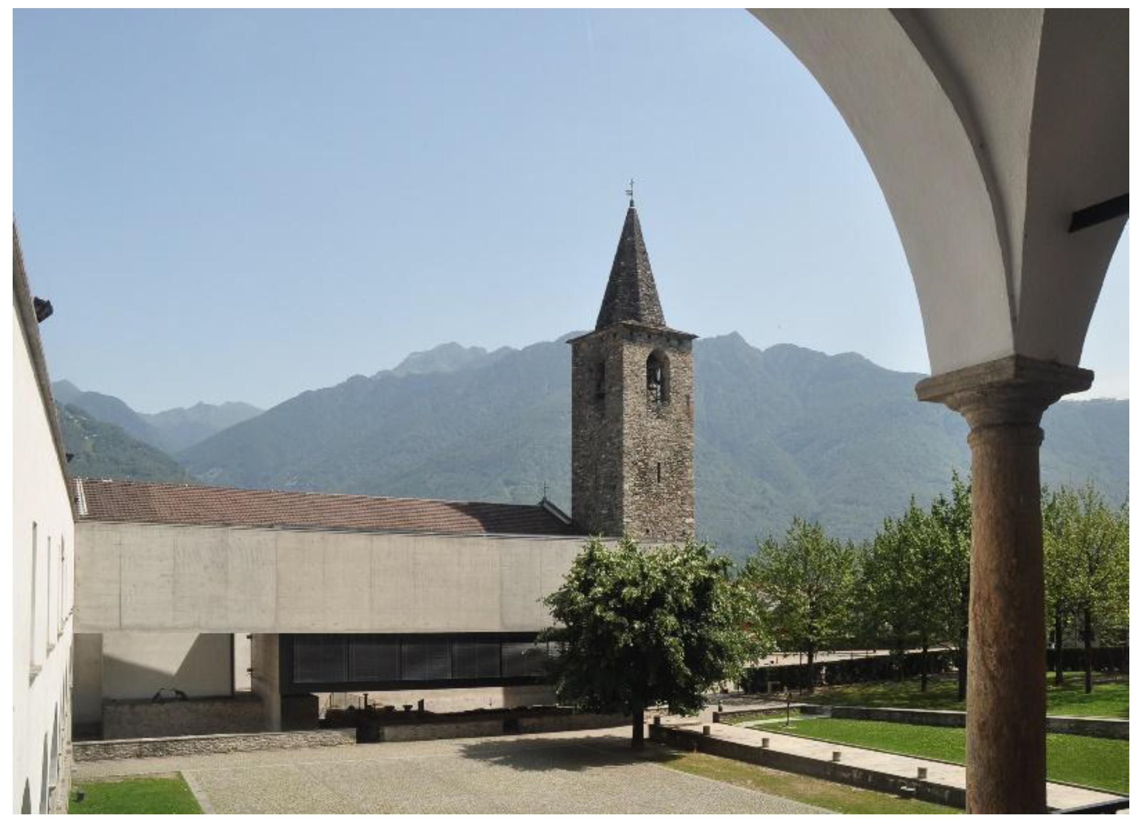
3.1.1. Geographical and Historical Location

The town of Monte Carasso is located in southern Switzerland, in the Canton of Ticino, Bellinzona Province. The dominant geographical elements are the alpine massifs, among which the only area available for development is the Ticino river valley. Monte Carasso stretches from the Mornera Hill in the north to the Ticino River in the southeast. On the southwestern side, it is limited by the Sementina stream, separating it from the twin town (also called Sementina).
Monte Carasso’s genesis dates to the 4th century. For most of its history, the town was a small center. In the late 19th and early 20th centuries, it experienced rapid demographic and urban growth due to the development of the ceramics industry.
The historical urban structure of the town is determined by its mountainous location. The non-orthogonal street grid is adapted to the topography. The urban fabric is fragmented—apart from a few large public buildings (town hall, church), it mainly consists of single-family buildings in the form of small townhouses. The main construction material is stone, articulated on a facade or covered with plaster. The degree of compactness of the fabric is considerable, although most of the old buildings are detached or semi-detached. The density is achieved by small distances between buildings, locating the building directly on the street line, and by the presence of opaque walls fencing the plots. These walls, usually made of raw local stone, are characteristic of Monte Carasso’s building culture.
In the second half of the 20th century, following global economic and urban trends, the town began to transform into the backyard of a larger urban center—Bellinzona. It was associated with a change in the functioning of the city itself and a gradual abandonment of traditional ways of living in favor of uniform western models (whose manifestation is an architectural type of detached single-family villa). The process was reinforced by the rapid development of road traffic, which resulted in the transformation of street spaces into roadways and the location of a motorway in the immediate vicinity of the town [43].
These processes, inherent to Monte Carasso, but also to most of the surrounding localities [44] (Figure 1), led to a gradual loss of identity and distinctiveness. It turned the localities into an undefined band of suburbs between Bellinzona and Locarno. Apart from the case of Monte Carasso, this process continues until today [45].

3.1.2. Luigi Snozzi in Monte Carasso

In this context, Monte Carasso stands out because of its extraordinary urban policy, conceived and developed by the architect Luigi Snozzi. He is recognized as one of four main architects of the so-called Ticino School (along with Mario Botta, Livio Vacchini, and Aurelio Galfetti), an influential movement in the architecture of the late 20th century. His legacy transcends his works and stems from an uncompromising moral attitude and an elevated sense of responsibility [46].
Luigi Snozzi started his activity in Monte Carasso in 1979 with a municipal commission for an architectural design for a new elementary school (as part of a modernist development plan). Approaching his task, Snozzi challenged the assigned location of the school in the developing suburbs of the town—near the highway, proposing to place it in the very center of Monte Carasso instead. His objective was to restore the town to its original structure based on a public central space.
The first step was to organize a school in the converted former Augustinian monastery (Figure 2). This initiative also resulted in a series of accompanying public spaces, including a central square created from the former monastery cloister. As a result of the favorable approach of the municipal authorities (especially town mayor Flavio Guidotti), in following years, Snozzi was able to design and build other facilities, both public (gymnasium, cemetery, multi-purpose hall), semi-public (bank branch), and prominent private (mayor’s house), in the center of Monte Carasso. Thus, the previously neglected historic center of the town was revived [41].
The positive results of this project paved the path for the formulation of a comprehensive concept of the whole of Monte Carasso’s spatial policy. Its main goal was to restore the traditional character of a small town with its local identity. Critical for its “urbanity”, the initiators of the re-urbanization process in Monte Carasso assumed that the social, cultural, and economic processes could be stimulated by creating urban conditions in a purely physical (morphological) dimension. Those conditions were described as follows:
  • High building density;
  • Strong and hierarchical structure;
  • Clearly delineated city limits;
  • Clear separation between private and public space (symbolic, as well as physical and visual);
  • Presence of a monumental and symbolic public space;
  • Secondary, “subordinated” role of natural elements within the urban fabric [42].
These values have been translated into reality through the spatial policy based on the local urban code, the establishment of the expert commission, and a number of auxiliary activities.

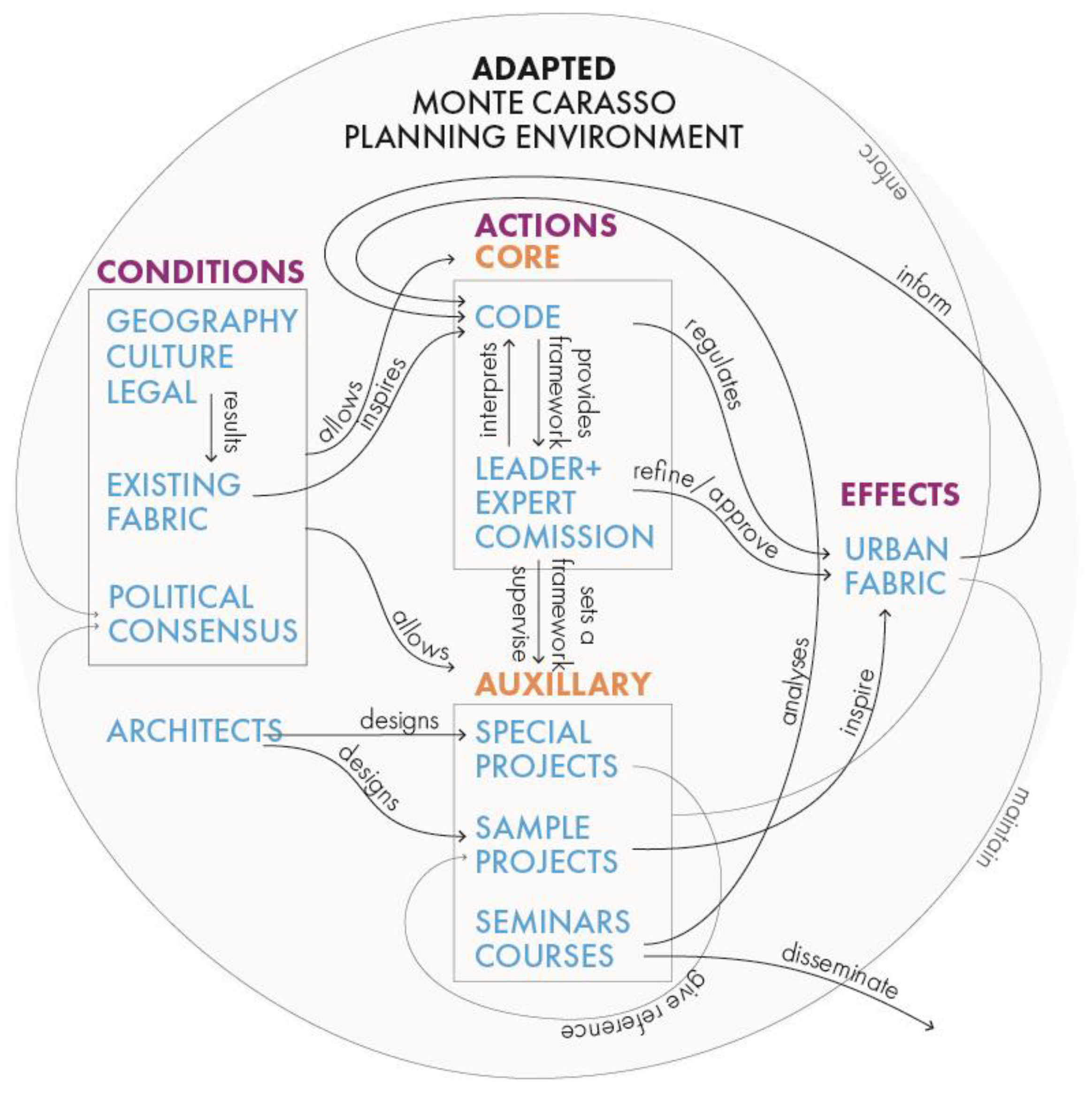
3.2. Elements of the Planning Environment of Monte Carasso

3.2.1. Spatial Planning in Ticino

The urban form of settlements in Switzerland, as in most countries, results from the interaction of a number of laws [47]. The most important of them are planning law and building law.
The Swiss system of spatial (or land use) planning is based on Article 75 of the Federal Constitution of the Swiss Confederation [48] and is regulated by the Federal Spatial Planning Act [49]. However, the implementation of the plans is mainly carried out by cantons [50], which, in turn, delegate part of the tasks to communes.
Building regulations are similarly decentralized. The specificity of the Monte Carasso spatial policy consists of combining the provisions of planning laws and the local (individual) regulations of building laws. Such a construction, where a single town has the mandate to fully control its planning/building laws (not just policy, thus moving beyond the local zoning/land-use plan) is unique to Switzerland, where national or regional (cantonal) regulations can be overridden on a local level (also in terms of direct democracy) [51]. The degree of local autonomy varies between cantons in Switzerland. In Ticino, it is considered to be relatively wide [52]. Generally, this local autonomy has been criticized for being unable to efficiently manage the urban growth, which led to urban sprawl [45], but in the case of Monte Carasso, it allowed the implementation of an original planning and building procedure that is the subject of this paper. This procedure is based on two pillars: a written code and an established expert commission.

3.2.2. Urban Code

The urban code of Monte Carasso is a set of rules that apply to all new forms of construction on its territory. It rejects traditionally understood zoning. For the vast majority of localities, the designation of areas with specific functions and parameters has been replaced by a set of rules concerning the physical development of the plot.
These rules are relatively simple and straightforward. The following are some of the most important regulations regarding buildings [53]:
  • Buildings can be built if:
    (…) the land is urbanized. The land is urbanized if there is sufficient access to it and the necessary water, energy, and sewage networks are close enough to be able to conclude a contract without easement;
    The plot must be used rationally and in moderation;
    Interventions on the plot (…) must be carried out taking into account, and respecting, the nature of the plot and the existing urban and architectural structure;
    There must be a reasonable relationship between the built-up and undeveloped areas;
    Only surfaces necessary for the use of the property in accordance with its intended use may be paved.
  • Regarding the distance of buildings from the plot boundaries,
    New buildings may be situated:
    Without windows—on the border with the neighboring plot;
    With windows—2 m from the border.
    From the side of existing buildings, the following distances should be kept:
    If there are doors, windows, and other viewing openings in the wall of the neighboring building, 4 m;
    If there are windows and other openings that only provide light (not viewing), or if there are no openings, 3 m.
    Owners can agree to reduce the indicated distances (…);
    The distance of new buildings from streets, squares in urbanized zones (…) can be built directly on plot edge.
  • In terms of building height,
    (…) Maximum height of new buildings up to 9 m; in addition, an additional 1.5 m may be allocated.
  • Regarding fences,
    From the side of streets and squares, the plots must be fenced with a wall of a minimum height of 0.8 m. (…);
    The maximum height of the walls is 2.5 m (…).
  • As regards parceling recomposition,
    Within building zones, where the layout of plots does not allow for their rational use, an order to modify the ownership system is introduced.
  • Regarding expert commission,
    The city office appoints a commission of three experts to:
    Provide advice to private owners on the proper use of plots of land for building purposes;
    Check all public and private projects.
In addition to those mentioned above, there are also some more detailed provisions, but they concern exceptional cases. As can be seen, these norms are often formulated in a subjective way. Terms such as reasonable, rational, and in moderation cannot be easily parameterized.

3.2.3. Expert Commission

Some rules that are not numerical or accurate, such as those regarding the reasonable use of land or adjusting to the urban structure, provide the basis for unequivocal decisions of the expert commission—an advisory body appointed by the town council. For a long time, the commission was composed of architects Luigi Snozzi, Roberto Briccola, and Raffaele Cavadini; its task was to advise, evaluate, and approve all construction initiatives in the town. Each investor, regardless of scale and project type, is invited, together with the commissioned architect, to a meeting with the expert commission at the town council. The approval granted by the Commission is necessary to obtain a building permit.
The presence of the human factor is a way to prevent the regulations from being circumvented (by exploiting loopholes). The dualism of this regulatory process is based on contrast: on the one hand, there is a closed and indisputable code, while on the other, there is an open and negotiating committee. Paradoxically, the written norms of the code were often more liberal than the hard views of the commission.

3.3. Auxiliary Activities

3.3.1. Design of Key Urban Elements

In order to make the intentions of a transformation of Monte Carasso explicit and to provide momentum, on the initiative of Snozzi, a number of architectural projects were undertaken on specific places of the town—the center, borders, and the regular spaces between them.
The restoration of the center (known as the Centro Monumentale) was initiated by adapting a former convent (at that time already split into private apartments) into a primary school. Thus, the center of the town was marked by two complementary public functions that determined its identity: a school, symbolizing community in its modern dimension, and a church, representing its tradition.
Another activity aimed at defining the town structure was establishing its clear boundaries. This was also accomplished through special architectural designs, in particular massive multi-family housing complexes and landscape designs. The above-mentioned key projects were created outside the formulated planning regulation system. They did not obey the described urban code, as their scope was to stand out from the regular fabric and mark special places in the settlement.

3.3.2. Design Examples of the Ordinary Urban Fabric

To serve as examples of typical town fabric, several single-family house designs were proposed by Luigi Snozzi and his associates (Figure 3). They fully obeyed the urban code, but at the same time, they are interesting examples of the “Ticino school” and minimalist architecture. They are also worth studying for their exceptional spatial and functional values; however, in this paper, this aspect cannot be covered. These successive projects contribute to the basic fabric of Monte Carasso. In this context, each of them plays a quadruple role, one that encompasses the following aspects:
  • Individual shelter—usually house for a single family;
  • Urban context, urban fabric—framing, creating walls and boundaries of public space;
  • Spatial cases, legal precedent—examining the rules of the code;
  • Informative example—educating investors and architects, whereby helping to overcome the patterns of thought that separate the idea of a private residence and the idea of a town.

3.3.3. Design Seminar

A design seminar entitled “Seminario Internazionale di Progettazione Monte Carasso” creates a context of urban development of Monte Carasso. It has occurred every year since 1993. It holds the form of a summer school/workshop aimed at students of architecture and young graduates. Over the course of 14 days, participants work in groups supported by tutors on specific subjects from the Monte Carasso and Bellinzona context. The subject may be place oriented (proposal for assigned location) or problem oriented (proposal to solve certain problems such as parking). Participants analyze and provide urban guidelines and design the physical environment.
One of the aims of the seminar is to disseminate knowledge about the design process in Monte Carasso and popularize its method. The seminar is a two-week architectural festival that integrates young professionals and the local community around architectural/urban discourse. Apart from regular research and design activities, a few special events are organized, such as lectures from prominent architects and urban designers (Figure 4).
Equally important, however, is the internal role of this event, which is based on an open, creative and professional discussion on the entire urban process. The idea is to crash-test—under controlled conditions—the urban procedure by pushing it to its limits. This is achieved by simulating a real design problem and checking its potential solutions, both within the existing system and outside it. The ideas and conclusions drawn from the seminar become the starting points for discussion on real urban, architectural, and legislative projects.

4. Spatial Characteristics

The spatial effects of Monte Carasso’s spatial policy were examined in two groups of criteria: numerical and descriptive. The first of these were compiled in two comparative tables for the town of Sementina. All data were acquired from the Open Street Map. A lack of perfect accuracy in this method can be justified by the non-critical role of the calculations. They are mainly used to confirm the intuitive perception of space as more or less compact.

4.1. Parameters

Table 1 shows the basic parameters of the examined settlements. Both of them have a similar population of about 3000 inhabitants, with Sementina being slightly more populated. The difference in urbanized areas is far more considerable, which results in a considerable difference in population density—the first indicator of settlement compactness. Sementina has more individual buildings with a larger gross footprint surface. However, the density of buildings is greater in Monte Carasso, both expressed as the number of buildings per hectare and built-up surface per hectare. The difference is greater in the former case, which suggests more fragmented urban tissue consisting of smaller buildings. This hypothesis is confirmed by the building footprint statistics (mean and median footprint). Both results are greater for Sementina, but the difference is more apparent in the former case, as the calculation is influenced by a few large-scale buildings, which are the subject of the last two columns in the table. As the analysis shows, Sementina has twice as many buildings with a footprint exceeding 500 m2, and it is the only town to have buildings over 2000 m2.
The results listed in the table show some spatial characteristics of Monte Carasso as being generally close to traditional small towns, which can be represented by the historic core of the nearby (and more “mature”) town of Giubasco (PpA = 11.44; BuD = 0.19). It is relatively densely populated and urbanized, with smaller buildings and with few medium-sized buildings being an exception and a spatial accent. No large-scale buildings are present that would be foreign to the particular building tradition.
Based on the desired pedestrian-oriented town mobility, the fabric of both settlements was examined for five-minute accessibility [54,55] on foot (pedestrian shed) from the focal point (FP) (Table 2). The zones of a normal five-minute walk, computed on the street network, were traced around town halls in variant 1 and around geometric centers of urbanized areas (centroids) in variant 2 (Figure 5). These zones were compared with the urbanized areas.
In variant A, the town areas accessible in a short walk are, in both cases, smaller than half of its total area. This is due to the eccentric location of town halls (especially in Monte Carasso, where it is placed near the northwestern edge of town). The number of accessible buildings is equal but encompasses a much smaller isochrone area, which shows the greater compactness of Monte Carasso. In variant B, the extent of accessible area is greater than half in both cases, but in Monte Carasso, it is as high as 68%. Additionally, the number of buildings “served” is relatively high, 380, which is over 75% of the total. In Sementina, on the other hand, the number of accessible buildings remains on the same level regardless of focal points. This shows the decrease in compactness in zones further from the town hall.

4.2. Descriptive Assessment

The above numerical examination can be compared and confirmed by the descriptive analysis.
Analysis of topographic maps (Figure 2 and Figure 6) shows that the area experienced rapid development of a similar pattern, especially in the decade 1970–1980. Later, the pattern of development in Monte Carasso and Sementino started to differ, becoming more organic and denser in the former and more orthogonal and looser in the latter. The contemporary map (Figure 6) reveals great differences in the urban fabric of the two neighboring towns. This can be derived both at the level of street pattern and typology of buildings. Monte Carasso appears more similar to the traditional irregular fabric of medieval towns, while Sementina is closer to a regular 20th-century development (especially sprawling suburbs).
The direct experience of Monte Carasso space—perceived from the perspective of pedestrians—reveals more interesting characteristics as follows:
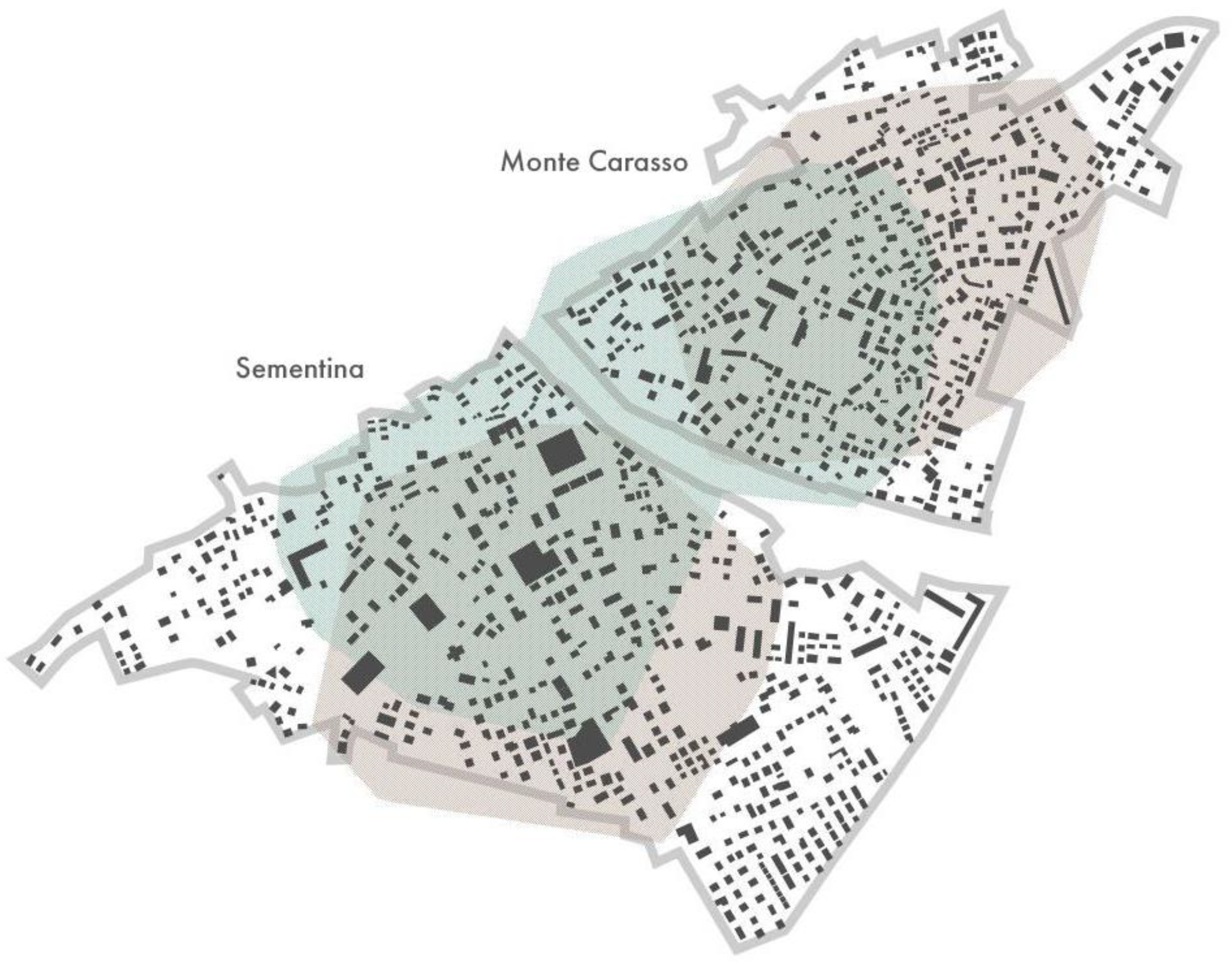
  • A visible border, i.e., a separation of the urban structure from its surroundings, which is a characteristic shared also by Sementina, although there is a visible pressure to develop lower parts of the hills to the north of both settlements;
  • An irregular form of public spaces resulting from the organic development of the urban fabric;
  • The legible enclosure of public spaces perceived as interiors with annexes;
  • A clear definition of spatial privacy through physical separation of a building or a wall;
  • Close viewing perspectives provide the ability to perceive details from close distances;
  • Spontaneous mobility, without segregating the various modes of transport;
  • Exclusive use of large-scale building types for public-use buildings;
  • Height of buildings of usually one or two stories, occasionally three;
  • “Personalization” of spatial issues, i.e., visibility of individual activity on the scale of the entire town.
The space of the town of Monte Carasso stands out from the surrounding towns, which, similar to Sementina and Giubiasco, have undergone significant spatial decline. Their public space has especially lost its consistency and has been dominated by transport infrastructure (transformed into exclusively car lanes between the buildings) (Figure 7; below). Monte Carasso was the only town to maintain a compact urban character typical of a historic settlement (Figure 7; above). It is still a traditional mountain town with winding streets and alleys, with the only atypical element being the aesthetic features of individual buildings. Their minimalist or brutalist architecture contrasts in style with the ordinary local urban fabric. While brutalist volumes of raw concrete may be shocking in such an environment, the space they create is actually very coherent. Despite modernized “language”, most features of the traditional town were maintained. These include a hierarchical structure with a clear center and small and fragmented buildings, defined public space, irregular shape of the plots, typology of buildings, functional structure, etc.
The most common building program—single-family houses—was adopted to construct the compact tissue. This is unlike Sementina and in other surrounding settlements, where houses generate suburban settings, and they do not relate to the public space.
It should be mentioned, however, that a number of issues in Monte Carasso have not yet found a satisfactory solution—first and foremost, individual car parking and everyday shopping (most of the supplies are provided in the neighboring town of Sementina in a large supermarket, which would not be allowed in Monte Carasso, what creates a controversial situation).
The noticeable functional scarcity in Monte Carasso highlights the limitation of purely “architectural” regulations present in the examined case. The mere use of existing housing typologies, coupled with an organic urban structure, does not grant “urbanity” per se to the settlement. It needs to be supported other policies (e.g., incentives) on an economic or social level.
Nevertheless, the spatial characteristics of Monte Carasso could certainly be judged as good and desirable.

5. Discussion

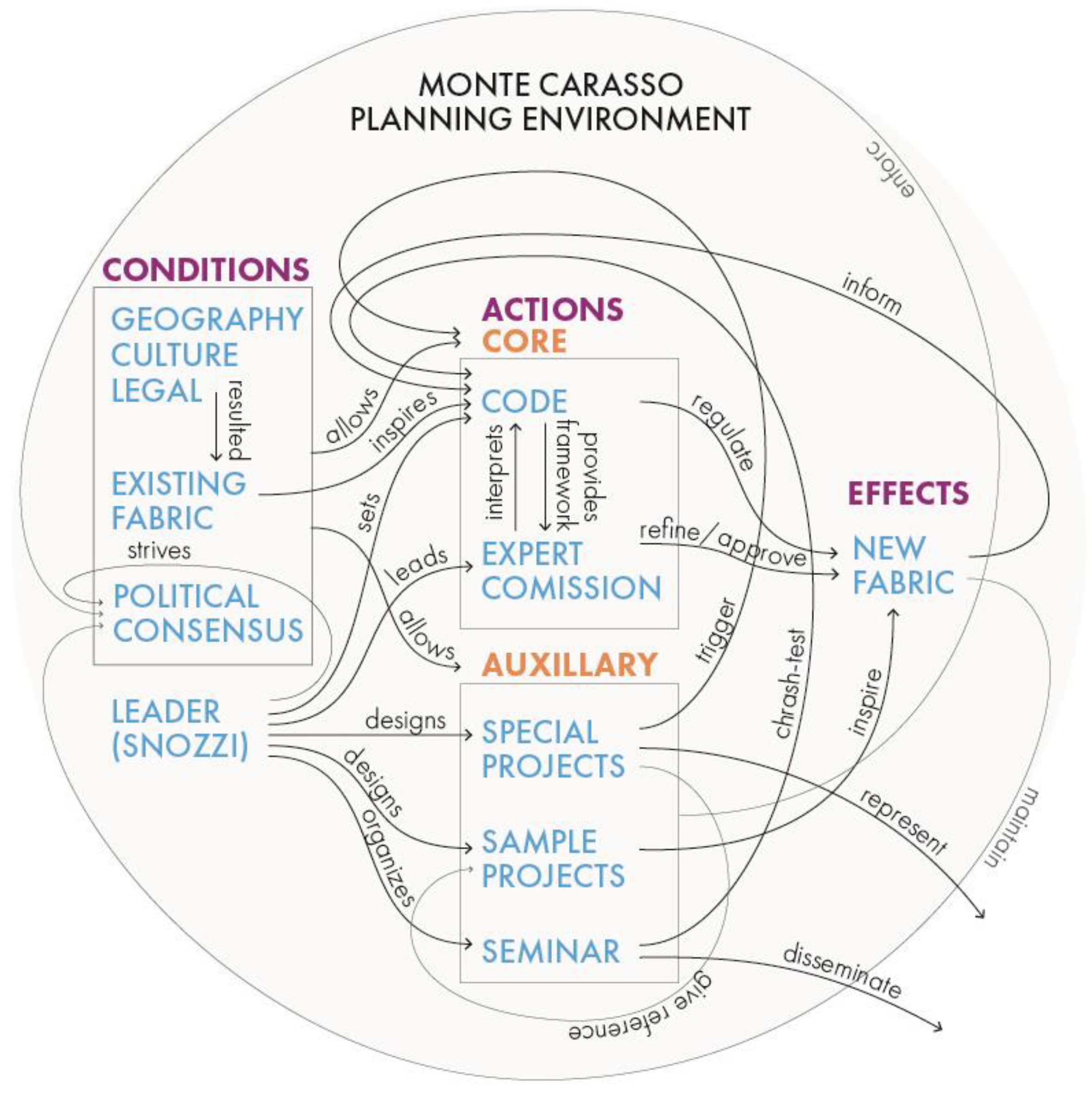
5.1. Mechanics of the Monte Carasso Planning Environment

Given the positive results of the Monte Carasso experiment, its replicability potential is worth considering. To make it possible, the abstract mechanics of the whole process need to be revealed. The diagram below (Figure 8) was designed to be such a representation.
The scheme was divided into three categories (columns), as in the presented paper. Basic relations between the elements are presented as labeled threads. In pre-existing geographic, cultural, legal, and urban conditions, the first step of the process was to involve the architect Luigi Snozzi, who assumed the role of the leader. The visible effect of his involvement was the implementation of a number of special projects, which built trust and readiness for future changes (political consensus). This enabled the introduction of the core of the planning system based on the urban code and expert commission. At the same time, Snozzi designed a number of exemplary projects to illustrate the intended direction of the reform. This triggered the real processes of transforming the town’s tissue. Already during the process, it has been enriched by a design seminar.
The relevance of the particular elements of the scheme are analyzed as follows:
  • Geographic and cultural conditions: As Snozzi himself claimed, followed by scholars [41,57], the civic culture of Switzerland, immersed in geographic context, played an important role in the implementation of the revolutionary planning procedure. Its most relevant elements included trust in institutions, respect for the law, good organization, and individual modesty. Climatic conditions, which could be considered as an important factor influencing the morphology (determined distances and parameters), had some significance, but they could hardly be proven as decisive for the success of the project. This is because similar traditional compact centers can be found in various geographical locations. The overall influence of these contexts is generally hard to assess objectively. They can be considered favorable but not determinant.
  • Legal conditions: In particular, the substantial autonomy of local (cantonal, municipal) governments in the Swiss Confederation enabled the use of the described procedure. While the local municipal mandate to control its territory by the planning process is generally a standard in most countries, the differentiation of construction law is much less frequent. This internal differentiation includes basic “technical” norms such as building distances and their relation with the public space. This element seems crucial in the procedure under consideration, as it could not be carried out without the possibility of overriding central building laws and regulations. The morphological provisions of the building code in Monte Carasso concern issues traditionally considered as “planning” (and most often under the authority of local government) such as land-use functions and parameters, but also (and mostly) include building regulations, which are usually regulated at the national level.
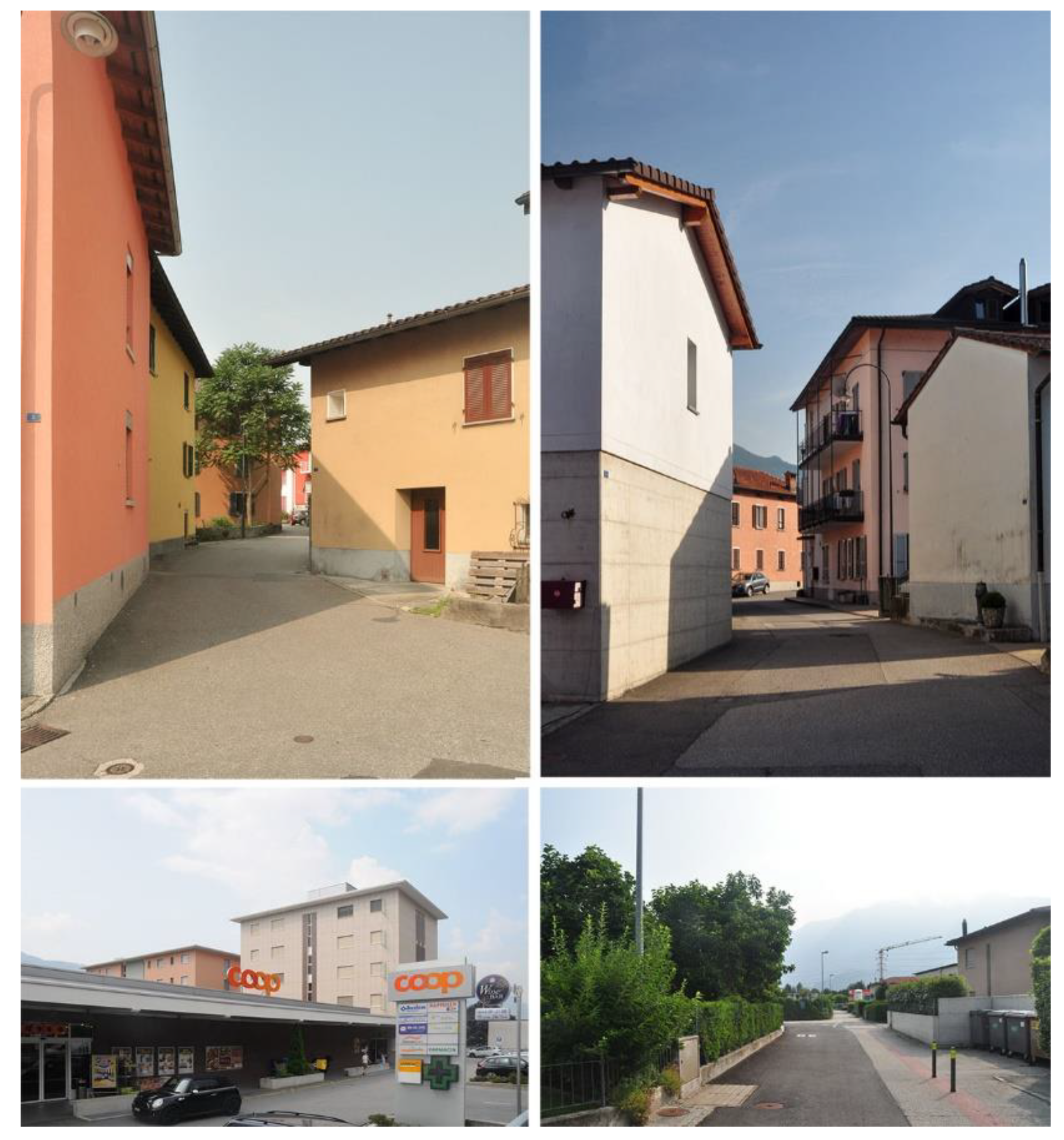
  • Existing urban fabric: With its legible morphological features, the historical tissue was a direct inspiration for the formulation of rules within urban code. The most important spatial characteristics, such as building typology and its dimensions, the close proximity of buildings, direct access to the buildings from the street, presence of high opaque walls were abstracted and parameterized within the provisions of the local law. The latter, despite the fact that it contains universal features for many historical towns, also has particular features that are typical for this alpine location (e.g., fencing walls). It is, therefore, a certain synthesis of the local building tradition.
  • Political consensus: This element was specified as a separate factor in the diagram despite its partial randomness and dependence on the cultural and legal context described above. The urban transformation of Monte Carasso could only have happened with the full support of local authorities. The relationship between an architect (Snozzi) and a politician (Guidotti) is often considered exemplary in this case. It was characterized by the absolute trust in each other’s competence, which made possible and even caused several controversial features of the process: the absence of fair competition among local professionals, top-down approach, and scarcity of local consultations/community engagement practices. It needs to be noted that the political consensus factor is dynamic, i.e., it changes over time. A minimum amount of political consensus is required to start the process, but it is being strengthened with establishing procedures and with its first positive effects. Despite the good results, however, the political consensus is prone to external interference and needs to be taken care of.
  • Leader: The role of Luigi Snozzi in the described urban transformation was absolutely central, especially in the first phase. This role consisted of conceiving the whole mechanism as well as developing and organizing it, monitoring and assessing its effects, as well as participating in it as a designer, tutor, and member of an expert commission. On the other hand, the exposed position of an architect may raise some doubts. It can even be seen as authoritarian. However, when assessing its importance, one must take into account that we are not dealing with a typical urban policy but with a pioneering experiment that required high discipline. Indeed the role of Luigi Snozzi was mitigated with time, as the procedure established itself. Partly embedded in this factor is the architect–politician relationship, which is described above. The possibility of such a relationship, however, was the result of the unique approach and moral attitude of Luigi Snozzi.
  • Urban code and expert commission: These are key elements and the heart of the entire mechanism. Their main importance lies in their departure from the practice of detailed building regulations toward a model in which general town planning provisions are accompanied by the ad hoc opinions of experts. The relations between objective and subjective criteria are interesting—the code includes both rules with specific parameters (“three floors”, “two meters”, etc.) as well as expressions such as “correct proportions’’ and “character of place”. Such a construction allows the enrichment of the planning process with the concepts that are difficult to parameterize, such as harmony or spatial order. In addition, it is somewhat reminiscent of the historical, vernacular way of creating towns, where the regulations mainly concerned dimensions and distances, while the typology, form, and detail resulted from tradition (well-established collective construction knowledge).
  • Special projects: Carrying out large projects had a double role. Firstly, it allowed the most important spatial problems of the city to be addressed in a precise and coordinated way. With the help of the larger resources involved, the key places in the town were developed, in both its center and outskirts. Secondly, these projects had a symbolic meaning, i.e., they allowed for a “new opening” and gave impetus to the planned reform. For this reason, they were crucial to the widespread acceptance and success of the project. In addition, the positive architectural effect of the special projects encouraged individual investors to commission their house designs to Luigi Snozzi.
  • Sample projects: It seems that the exemplary implementation of a number of ordinary” projects to visualize the functioning of the new urban code was equally important. Designs of regular urban fabric have proven that it is possible to move away from the typical suburban pattern of single-family housing and that the traditional town form is not outdated. This example allowed the community to accept the new regulations. However, the mere commissioning of Snozzi’s projects was not obvious, and it seems that it was only possible due to the earlier success of his architectural intervention in the center of the town.
  • Design Seminar: The role of the seminar for the very process of Monte Carasso’s transformation seems to be secondary. It facilitated the testing of a number of solutions, but they would have probably been implemented without it. It was of greater importance for the popularization of the Monte Carasso case outside its geographical context.
  • A new urban fabric: The existence of a certain amount of new (based on the urban code) urban fabric at a specific point in time was critically important. It gave confidence in the new law and allowed the entire construction initiative to be shifted onto new tracks. This created a situation in which investments based on new rules became normal and natural in their context, as opposed to the (previously obvious) suburban types of buildings.
  • Outcomes: Recognition and appreciation of the Monte Carasso case beyond its original geographical context were important for its internal acceptance. Even if not immediately understood, controversial urban processes were more easily accepted by residents when they were awarded or presented at prestigious exhibitions.
After understanding the importance of individual elements of the system for the success of the Monte Carasso case, we can now reflect on their potential of replicability.

5.2. Potential of Adaptation

This section describes the system’s individual elements in terms of their potential utility beyond the original environment. It was considered how each of them could be applied in different contexts. This comparison was discursive in nature, with questions asked rather than ready-made answers being provided. The description indicates the doubts and potential paths toward further exploration. It is not a detailed analysis, as this would have to be carried out separately for each of the target contexts.
  • Geographic and cultural conditions: As stated, a similar morphological character could be found in most small-town centers in Europe. Therefore, if historically it was possible to produce compact urban organisms in various geographical conditions, it should also be possible today. Some details, such as the numerical values of parameters or rules regarding the opacity of walls would probably be different depending on the climate and culture, but they would not undermine the essence of the system. The next factor, civic culture, may be of greater importance, as it determines the way of perceiving the top-down regulations. Depending on the tradition of a given country, it would require adapting the methods and schedule of introducing new regulations for each of the target contexts separately.
  • Legal conditions: Certain legal autonomy of the local administrative entity is a condition for the application in an individual planning procedure. The mere introduction of unique urban codes for the area of a single town would have to be associated with granting it considerable legislative independence. It seems that it would be easier at the planning level than at the system level. This means that, under the local law, it would be possible to override general building regulations (e.g., exemption, derogation from the need to maintain minimum fire distances). An alternative would be to introduce top-down special technical regulations for the entire settlement category of small towns. Such regulations would take into account the fragmented and compact spatial character of towns (as opposed to large cities or dispersed rural areas). A more complex issue is the possibility of appointing and conferring competences on an expert commission. This moves beyond the planning sphere (even broadly understood along with technical and construction regulations) and concerns the form of the self-government system itself. In summary, it seems that granting considerable decision-making independence to local governments would be the optimal way.
  • Existing urban fabric: Examined and analyzed and then synthesized and parameterized, this should be the basis for formulating the principles of local urban law. Such a process should begin with historical research identifying the characteristic features and evolution of the local building culture over time. It would be a morphological study because it concerns the built-up fabric itself, as well as invisible elements, in particular the system of public spaces and the property structure (parcellation). Only in relation to the latter should the three-dimensional form of the city be analyzed—starting from typological issues, through architectural issues (forms and details), and ending with the construction patterns (techniques and materials). Such an analysis necessarily includes some elements of valorization, as not all urban facts are equally relevant (in the context of establishing or revealing patterns).
An important issue is to identify the manner in which the various functional programs of the development were manifested. In the absence of some of them in the tradition (large-size objects), perhaps some elements of critical foresight will be needed. Within the identified forms of development, key features should be distinguished, such as relations with public and private space, the location of buildings on the plot, characteristic dimensions, and a set of details. Some of these principles may be similar within the group of small towns on a more general level, e.g., striving for compactness and clear delimitation of public and private space, but may differ in terms of the location of buildings, their specific features, and numerical parameters. This all depends on the specific characteristics of the local building culture.
4.
Political consensus: The introduction of innovative planning regulations that would change the rules of local investment must be fully supported by the local authority. In that sense, it must, in part, be a political project, requiring initial trust and possibly an endorsement of the central government. Political consensus may be considered as the main challenge when a non-standard regulatory solution is introduced [26]. However, with a relatively smaller “decision structure”, small towns may overcome this problem more easily, because fewer people need to be convinced initially. When this occurs, effects could be achieved in a perspective longer than a single term of local government. Ensuring the continuity of the process would be the task of an independent body, a substantive multipartisan commission that would have the capacity to build support around the project, regardless of the ruling option. The feasible mode of functioning of such a commission is one of the main challenges of adapting the described system.
5.
Leader/expert commission/architects: The process of spatial redevelopment of towns needs a guide, especially in the initial phase. In the case of Monte Carasso, the leader was, in a way, self-proclaimed, but in order to replicate such a procedure, his systemic role should be provided. This means that he must be appointed to a specific formal and legal position with substantial power granted. In different European contexts, various positions are devised, such as chief urban architect, urban planner, chairman of the town planning, and architectural commission. It depends on the legal and political structure considered earlier. As in the Monte Carasso case, the leader should be the head of the expert commission. In fact, his/her duties could be distributed among members of the commission. The challenge is to find professionals with sufficient experience, competence, and attitude to sit in the expert commission. An issue worth discussing is the possible sharing of such a body with a group of neighboring towns.
An important issue is the role of local architects, who are, in a way, a natural expert base in particular areas. While in Monte Carasso the group was dominated by Snozzi himself and his followers, in the adapted environment, the involvement of architects could be used more fully. This applies to their direct participation in the expert committee, but also to their wider involvement in pilot urban and architectural projects (special projects).
6.
Urban code and expert commission: The two are designed to work together in order to take full advantage of their complementary nature. It seems that in the context of repeating this method elsewhere, it is absolutely necessary to stick to this combination with its fragile balance. The provisions cannot be too rigid so as to not marginalize the role of the committee and reduce it to the role of an “ornament”. They cannot be too open either, as this would give the committee too much power and risk abuse. Considerable caution is required when formulating specific provisions. It seems that the Monte Carasso set of rules can serve as a starting point that could be adapted to local conditions. However, creating a much-nuanced adaptation of these rules could be counterproductive, because the strength of the Monte Carasso urban code lies in its concise synthesis, which is only supplemented by the contribution of the expert commission. The danger of unification of the built environment in many towns as a result of applying similar provisions is a potential problem. However, it seems that despite the significant differences in geographical and cultural contexts, urban/architectural patterns at a basic level (such as those governed by the urban code) are very similar across Europe. Therefore, it should not be a problem for similar provisions to regulate many towns within one region or even a country. It is the role of a commission to skillfully guide it toward distinguishable identities.
7.
Special projects: The implementation of the new planning procedure accompanied by significant special projects proved to be an effective method that is worth repeating. The necessity to invest public money in this type of project is facilitated in the European context by the possibility of applying for targeted subsidies from the European Union (EU). Subsidies for this type of project (particularly the renovation of public spaces in small towns) have been (and are) awarded, as part of a Cohesion Fund [58] or Regional Development Fund [59], particularly in the poorer regions of the EU. Moreover, projects financed in this way were often carried out randomly, without substantive justification [60,61,62], which resulted in questionable quality. Including them in a larger, more structured, and well-thought-out procedure could be beneficial. Such public realizations could become part of a larger project and could be continued in the form of a sophisticated urban policy. It could ensure long-lasting results. Such sustained results, which may be called revitalization, are the intended goal of EU financial support. In the proposed scheme, the role of the leader and the advisory committee would be to prepare this type of investment. This could be accomplished by consulting and selecting its location, organizing a competition, or through a design process, until the commencement of implementation. This means that the creation of an appropriate committee should precede any design and implementation activities—unlike in Monte Carasso.
8.
Sample projects: The existence of appropriate individual projects could be difficult, as it would require encouraging private investors to break down established patterns of thought and action, and experiment by themselves. The model of compact living within the core of a historic town is now less acceptable (or even considered obsolete) than the scattered and suburban model. Perhaps a chance for such exemplary projects in the first phase would be municipal social housing.
9.
Design Seminar: The emergence of a substantive—and at the same time open—discussion on the town spaces provided by student workshops is important from the point of view of the durability of the effects and appropriate social acceptance of the policy pursued. Certain involvement of the local community in these seminars is especially desirable. It would be helpful in reaching a democratic consensus that could counterbalance, to a certain extent, the predominant role of a single leader (Snozzi in the original case).
The existence of such a seminar as part of the planning environment is realistic, although it seems that in view of the potentially wider application of the procedure it would not be essential. The more common, repetitive nature of such a policy would allow a more systemic (rather than individual) way of conducting such a discussion, e.g., through constant cooperation with universities, rotating architecture festivals, and summer schools. The process of professional education is related to another challenge of innovative planning, which is the shortage of staff [26]. Technical offices that deal with planning are often insufficiently staffed and their responsibilities are broad. As a result, the decisions made are schematic and conservative. At the same time, the educational background of officials is diverse; therefore, adequately addressing the substantive scope of their education is a challenge. In such a situation, rather than looking for the respective study programs to be modified, the better option would be the introduction of new planning content through post-graduate training, for example, described seminar-type courses.
10.
New urban fabric: An important condition for the success of the process is a critical mass effect. This means a moment when new investments created under the urban code (together with the carried-out special projects) create a compact space or at least a fragment of it. They could be perceived as examples of a renewed, urban quality. Only a promising initial effect would allow the operation to continue. Therefore, a necessary condition is the pre-existence of a certain investment dynamic. Firstly, this means that towns suitable for the introduction of the new planning policy are those characterized by a significant construction initiative, and secondly, that there must be certain restrictions on the expansion of the urbanized zone in order to stimulate their internal compaction.
11.
Outcomes: Cooperation between municipalities is also important, mainly as an exchange of experiences, mutual support, and encouragement. It is also important in the context of the stiffness of the mechanism—while introducing initially controversial compactness, the challenge is to avoid unconvinced investors turning away to build in neighboring towns, where such regulations would not exist.
This analysis leads to subtle modification of the previous scheme (Figure 9). A further refinement would require the adoption of a specific local context as a reference point.

6. Conclusions

The success of Monte Carasso’s urban transformation can be proven through its maintenance or recreation of typical compact small-town character (measured both in numeric values and immeasurable, yet perceivable, features). In Monte Carasso, it was possible to face the threats typical of today’s developed world, including suburbanization and the blurring of the identity of small towns. It is a rare example of modern single-family housing contributing to a town’s “urbanity” through a set of rules, uncompromisingly referring to the traditional morphology of a small town. As Roger Diener writes, “the town evolves while maintaining its authenticity. New forms express its authenticity” [17].
Importantly, the new urban regulations (especially the urban code) were accepted by the inhabitants and even gained their recognition. Residents appreciate the spatial uniqueness of Monte Carasso and identify it with the intervention of Luigi Snozzi, which was reflected in the award of honorary citizenship given to him [63].
The most distinguishing features of the Monte Carasso spatial regulatory environment can be summarized as follows:
  • Two-stage urban regulation: universal written rules and decisions of an expert commission;
  • Simplicity: low number of rules and clear wording;
  • Regulatory humanism: precise (numerical) provisions, apart from imprecise ones (referring to general concepts and subject to interpretation);
  • Subjectivity: making the shape of the space dependent on the subjective opinions of a group of experts;
  • Form-based orientation: treating the built form (urban morphology) as the most important planning goal that eventually determines usage and social character;
  • Limited manual control: individual special design for priority locations within the town (center and suburbs);
  • Specific understanding of heritage: priority of structure (topography, urban patterns, parceling geometry) and typo–morphology (the relationship between building and open space) in relation to form, style, and substance;
  • Opening the professional discussion on the town’s urban development to the architects and students of architecture.
These features, as well as the whole mechanics of the system, could be adopted in other European regions (and possibly beyond). Detailed analyses of possibilities and limitations of its application within specific contexts should be undertaken. These would cover their adaptation to local climatic, cultural, and legal conditions.
An analysis of the whole regulatory “ecosystem” of Monte Carasso reveals its universal potential—a possibility of being replicated in other geographical and cultural contexts. This process would require careful adaptation of specific elements of the original case. This paper traced a framework for such a process.
First of all, understanding and appreciating the key role of the leader, Luigi Snozzi, necessitates realizing his uniqueness and unreplicability. Thus, the adaptation of the Monte Carasso planning procedure to a wider application must systematically replace the person–leader with more complex entities and their interactions. It means, in a way, “disarming” the role of a leader and expanding their competences to a wider group of stakeholders. At the same time, the process of adaptation would need to face and deal with some drawbacks of the original case—namely, top-down approach, insufficient citizen participation, partial marginalization of the architects’ community, excessive monumentality, and simplification of urban projects.
It seems that some of these problems may be solved by the aforementioned easing of the importance of the process leader (however, this does not diminish the importance of Snozzi’s legacy).
In addition, strict, regulatory problems remain to be solved, such as the mentioned difficulties in adapting the rules to a contemporary lifestyle with its characteristic artifacts (large-area stores, cars). In this respect, a solution should be sought in the very method of creating a local urban code. This process (without losing its strength of simplicity) must be multifaceted and inclusive, open to interdisciplinary discussion.

Funding

This research received no external funding.

Data Availability Statement

Not applicable.

Conflicts of Interest

The authors declare no conflict of interest.

References

  1. Knox, P.; Meyer, H. Small Town Sustainability: Economic, Social, and Environmental Innovation; Birkhauser: Basel, Switzerland, 2013. [Google Scholar]
  2. Servillo, L.; Atkinson, R.; Hamdouch, A. Small and medium-sized towns in Europe: Conceptual, methodological and policy issues. Tijdschr. Econ. Soc. Geogr. 2017, 108, 365–379. [Google Scholar] [CrossRef]
  3. UN-Habitat—United Nations Human Settlements Programme. World Cities Report; United Nations Human Settlements Programme: Nairobi, Kenya, 2020. [Google Scholar]
  4. Strijker, D. Marginal lands in Europe—Causes of decline. Basic Appl. Ecol. 2005, 6, 99–106. [Google Scholar] [CrossRef]
  5. Bănică, A.; Istrate, M.; Tudora, D. (N)ever Becoming Urban? The Crisis of Romania’s Small Towns. In Peripheralization; Fischer-Tahir, A., Naumann, M., Eds.; Springer: Wiesbaden, Germany, 2013. [Google Scholar] [CrossRef]
  6. Bartosiewicz, B.; Kwiatek-Sołtys, A.; Kurek, S. Does the process of shrinking concern also small towns? Lessons from Poland. Quaest. Geogr. 2019, 38, 91–105. Available online: https://doi-1org-1000098l80ac7.eczyt.bg.pw.edu.pl/10.2478/quageo-2019-0039 (accessed on 7 May 2021).
  7. Fonseca, M.L. New waves of immigration to small towns and rural areas in Portugal. Popul. Space Place 2008, 14, 525–535. [Google Scholar] [CrossRef]
  8. Lazzeroni, M. Industrial decline and resilience in small towns: Evidence from three European case studies. Tijdschr. Econ. Soc. Geogr. 2020, 111, 182–195. [Google Scholar] [CrossRef]
  9. Pirisi, G.; Trócsányi, A. Shrinking small towns in hungary: The factors behind the urban decline in” small scale”. Acta Geogr. Univ. Comen. 2014, 58, 131–147. [Google Scholar]
  10. Wirth, P.; Elis, V.; Müller, B.; Yamamoto, K. Peripheralisation of small towns in Germany and Japan–Dealing with economic decline and population loss. J. Rural Stud. 2016, 47, 62–75. [Google Scholar] [CrossRef]
  11. Powe, N.; Hart, T. Planning for Small Town Change; Routledge: Abingdon, UK, 2017. [Google Scholar]
  12. Gerber, J.-D. The managerial turn and municipal land-use planning in Switzerland—Evidence from practice, Plan. Theory Pract. 2016, 17, 192–209. [Google Scholar] [CrossRef]
  13. Bell, D.; Jayne, M. Small cities? Towards a research agenda. Int. J. Urban Reg. Res. 2009, 33, 683–699. [Google Scholar]
  14. Mayer, H.; Knox, P. Small-town sustainability: Prospects in the second modernity. Eur. Plan. Stud. 2010, 18, 1545–1565. [Google Scholar] [CrossRef]
  15. Steinführer, A.; Vaishar, A.; Zapletalová, J. The Small Town in Rural Areas as an Underresearched Type of Settlement. Editors’ introduction to the Special Issue. Eur. Countrys. 2016, 8, 322. [Google Scholar] [CrossRef] [Green Version]
  16. Meili, R.; Mayer, H. Small and medium-sized towns in Switzerland: Economic heterogeneity, socioeconomic performance and linkages. Erdkunde 2017, 71, 313–332. [Google Scholar] [CrossRef]
  17. Disch, P. Luigi Snozzi: Costuzioni e Progetti; ADV Publishing: Lugano, Switzerland, 1994. [Google Scholar]
  18. Snozzi, L. Monte Carasso: La Reinvenzione del Sito; Birkhauser: Basel, Switzerland, 1995. [Google Scholar]
  19. Bologna, A. Luigi Snozzi e l’utopia realizzata a Monte Carasso (Canton Ticino): IL villaggio rurale divenuto centro: 1979–2009. Storia Urbana 2014, 95–112. [Google Scholar] [CrossRef]
  20. Lazzati, G.; Lo Conte, A. Luigi Snozzi a Monte Carasso; Maggioli Editore: Milano, Italy, 2014. [Google Scholar]
  21. Pedrycz, P. The role and responsibility of an architect in small town. In Education for Research—Research for Creativity; Słyk, J., Bezerra, L., Eds.; Wydział Architektury Politechniki Warszawskiej: Warszawa, Poland, 2016; pp. 266–272. [Google Scholar]
  22. Batty, M. Big data, smart cities and city planning. Dialogues Hum. Geogr. 2013, 3, 274–279. [Google Scholar] [CrossRef] [PubMed]
  23. Kropf, K. Urban tissue and the character of towns. Urban Des. Int. 1996, 1, 247–263. [Google Scholar] [CrossRef]
  24. Tröger, E.; Eberle, D. Density & Atmosphere; Birkhäuser: Berlin, Germany; München, Germany; Boston, MA, USA, 2014. [Google Scholar] [CrossRef]
  25. Samuels, I. A typomorphological approach to design: The plan for St Gervais. Urban Des. Int. 1999, 4, 129–141. [Google Scholar] [CrossRef]
  26. Samuels, I.; Pattacini, L. From description to prescription: Reflections on the use of a morphological approach in design guidance. Urban Des. Int. 1997, 2, 81–91. [Google Scholar] [CrossRef]
  27. Oliveira, V.; Silva, M.; Samuels, I. Urban morphological research and planning practice: A Portuguese assessment. Urban Morphol. 2014, 18, 23–39. [Google Scholar]
  28. Ye, L. Chinese Urban Design: The Typomorphological Approach. Urban Policy Res. 2015, 33, 127–130. [Google Scholar] [CrossRef]
  29. Ünlü, T. Planning Practice and the Shaping of the Urban Pattern. In Teaching Urban Morphology; Oliveira, V., Ed.; Springer: Cham, Switzerland, 2018; pp. 31–49. [Google Scholar] [CrossRef]
  30. Xie, S. Learning from Italian Typology- and Morphology-Led Planning Techniques: A Planning Framework for Yingping, Xiamen. Sustainability 2019, 11, 1842. [Google Scholar] [CrossRef] [Green Version]
  31. Talen, E. Design by the rules: The historical underpinnings of form-based codes. J. Am. Plan. Assoc. 2009, 75, 144–160. [Google Scholar] [CrossRef]
  32. Oliveira, V. The Study of Urban Form: Different Approaches. In Urban Morphology; The Urban Book Series; Springer: Cham, Switzerland, 2016. [Google Scholar] [CrossRef]
  33. Friedman, A. Planning Small and Mid-Sized Towns: Designing and Retrofitting for Sustainability; Routledge: New York, NY, USA, 2014. [Google Scholar]
  34. Open Street Map. Available online: https://www.openstreetmap.org (accessed on 14 October 2021).
  35. QGIS Software. Available online: https://qgis.org (accessed on 14 October 2021).
  36. QuickOSM. Available online: https://docs.3liz.org/QuickOSM/ (accessed on 14 October 2021).
  37. ORS Tools Plugin. Available online: https://github.com/GIScience/orstools-qgis-plugin/wiki/ (accessed on 14 October 2021).
  38. Eurostat. Statistics Explained: Urban-Rural Typology. Available online: https://ec.europa.eu/eurostat/statistics-explained/index.php?title=Glossary:Urban-rural_typology) (accessed on 7 May 2021).
  39. Wirth, L. Urbanism as a Way of Life. Am. J. Sociol. 1938, 44, 1–24. [Google Scholar] [CrossRef]
  40. Doxiadis, C.A. Ekistics: An Introduction to the Science of Human Settlements; Oxford University Press: New York, NY, USA, 1968. [Google Scholar]
  41. Croset, P.A. Luigi Snozzi and Monte Carasso: A long running experiment. Luigi Snozzi, sul progetto di Monte Carasso. Casabella 1984, 506, 122–124. [Google Scholar]
  42. Snozzi, L. Auf den Spuren des Ortes; Museum für Gestaltung: Zuerich, Switzerland, 1996. [Google Scholar]
  43. Schwick, C.; Jaeger, J.A.G.; Bertiller, R. Urban Sprawl in Switzerland—Unstoppable? Quantitative Analysis 1935 to 2002 and Implications for Regional Planning; Haupt: Bern, Switzerland, 2012. [Google Scholar]
  44. TUM, Gruppo di lavoro VAI. Modelli di Insediamento Alpino. Progetti Urbanistici Modello|Qualità Esemplari Specifiche; Comunita di Lavore delle Regioni Alpine: Bolzano, Italy, 2007. [Google Scholar]
  45. Klaus, J. Do municipal autonomy and institutional fragmentation stand in the way of antisprawl policies? A qualitative comparative analysis of Swiss cantons. Environ. Plan. B Urban Anal. City Sci. 2020, 47, 1622–1638. [Google Scholar] [CrossRef]
  46. Diener, R. “…al di là dell’orizzonte c’è la città”—Omaggio a Luigi Snozzi; Lecture. Available online: https://vimeo.com/519563182 (accessed on 7 May 2021).
  47. Larsson, G. Spatial Planning Systems in Western Europe: An Overview; IOS Press: Delft, The Netherlands, 2006. [Google Scholar]
  48. Swiss Confederation. Federal Constitution of the Swiss Confederation, of 18 April 1999 (Status as of 7 March 2021). Available online: https://www.fedlex.admin.ch/eli/cc/1999/404/en#art_75 (accessed on 2 November 2021).
  49. Swiss Confederation. Federal Act on Spatial Planning (Spatial Planning Act, SPA), of 22 June 1979 (Status as of 1 January 2019). Available online: https://www.fedlex.admin.ch/eli/cc/1979/1573_1573_1573/en (accessed on 2 November 2021).
  50. IL Gran Consiglio della Repubblica e Cantone Ticino. Legge Cantonale di Applicazione della Legge Federale sulla Pianificazione del Territorio (del 23 Maggio 1990). Available online: https://www.lexfind.ch/tolv/120246/it (accessed on 2 November 2021).
  51. Muggli, R. Spatial Planningi Switzerland: A Short Introduction; Swiss Planing Association VLP-ASPAN: Bern, Switzerland, 2004. [Google Scholar]
  52. Mahaim, R. Le Principe de Durabilite’ et L’ame’Nagement du Territoire. Le Mitage du Territoire àL’épreuve du Droit; Schulthess: Geneve, Switzerland, 2014. [Google Scholar]
  53. Comune di Monte Carasso. Norme di Attuazione del Piano Regolatore del Comune di Monte Carasso; REGNAPR. 1992. Available online: https://www.bellinzona.ch/downdoc.php?id_doc=50491&lng=1&i=1&rif=0f0fe771bb (accessed on 14 October 2021).
  54. El-Geneidy, A.; Grimsrud, M.; Wasfi, R.; Tétreault, P.; Surprenant-Legault, J. New evidence on walking distances to transit stops: Identifying redundancies and gaps using variable service areas. Transportation 2014, 41, 193–210. [Google Scholar] [CrossRef]
  55. Mehaffy, M.W.; Porta, S.; Romice, O. The “neighborhood unit” on trial: A case study in the impacts of urban morphology. J. Urban. Int. Res. Placemaking Urban Sustain. 2015, 8, 199–217. [Google Scholar] [CrossRef]
  56. Snozzi, L.; Merlini, F. L’architettura Inefficiente; Edizioni Sottoscala: Bellinzona, Switzerland, 2014. [Google Scholar]
  57. European Commision. Cohesion Fund 2014–2020. Available online: https://ec.europa.eu/regional_policy/en/funding/cohesion-fund/2014-2020 (accessed on 14 October 2021).
  58. European Commision. European Regional Development Fund 2014–2020. Available online: https://ec.europa.eu/regional_policy/en/funding/erdf/2014-2020 (accessed on 14 October 2021).
  59. Bradley, J. Evaluating the impact of European Union Cohesion policy in less-developed countries and regions. Reg. Stud. 2006, 40, 189–200. [Google Scholar] [CrossRef]
  60. Komornicki, T.; Szejgiec-Kolenda, B.; Degórska, B.; Goch, K.; Śleszyński, P.; Bednarek-Szczepańska, M.; Siłka, P. Spatial planning determinants of cohesion policy implementation in Polish regions. Eur. XXI 2018, 35, 69–87. [Google Scholar] [CrossRef]
  61. Medeiros, E. Assessing Territorial Impacts of the EU Cohesion Policy: The Portuguese Case. Eur. Plan. Stud. 2014, 22, 1960–1988. [Google Scholar] [CrossRef]
  62. Carasc. Luigi Snozzi Cittadinanza Onoraria. Available online: https://www.carasc.ch/Luigi-Snozzi-cittadinanza-onoraria-2e233c00 (accessed on 7 May 2021).
  63. Cullen, G. Concise Townscape; Routledge: Abingdon, UK, 2012. [Google Scholar]
Figure 1. Topographic map of two settlements divided by the Sementina stream: Monte Carasso (northeast) and Sementina (southwest) successively from 1970, 1980, 1990, and 2018. Source: Swisstopo 2021.
Land 10 01235 g001
Figure 2. Ex-Augustinian convent converted into a primary school—the symbol of Monte Carasso’s urban transformation. Source: Author.
Land 10 01235 g002
Figure 3. Typical small-town cul-de-sac created by traditional buildings with the significant contribution of those regarded as contemporary (at the end is Casa Stefano Guidotti by Luigi Snozzi). Source: Author.
Land 10 01235 g003
Figure 4. Public event during the design seminar gathering specialists and the local community. Source: Author.
Land 10 01235 g004
Figure 5. Figure–ground schemes of Monte Carasso and Sementina with delimitation of urbanized areas and five-minute pedestrian access zones: green—from town hall; red—from geometric center. Source: Author.
Land 10 01235 g005
Figure 6. Contemporary topographic map of Monte Carasso (northeast) and Sementina (southwest). Source: Swisstopo 2021.
Land 10 01235 g006
Figure 7. Typical space of Monte Carasso (above) and Sementina (below). It is clear that in the former case the built fabric contributes to demarcation of public space and creates much “richer” relations [56], while in the latter case, the relationship between buildings and space between them is merely functional. Source: Author.
Land 10 01235 g007
Figure 8. Mechanism of the Monte Carasso spatial regulatory environment with the sequence of elements. Source: Author.
Land 10 01235 g008
Figure 9. Proposal of adaptation Monte Carasso spatial environment’s mechanics to the general context of other small towns. Source: Author.
Land 10 01235 g009
Table 1. Basic urban parameters of Monte Carasso and Sementina.
UAPPDNBBpAƩBABuDBFmnBFmdNB>500NB>2000
[ha] [1/ha] [1/ha][m2] [m2][m2]
Monte Carasso46.5728726249510.6382,6830.18167145100
Sementina69.613217465537.94117,6800.17212159204
UA—urbanized area; P—population; PD—population density; NB—number of buildings; BpA—building per hectare; ƩBA—sum of built-up areas; BuD—built-up density; BFmn—mean building footprint; BFmd—median building footprint; NB>500—number of buildings with footprint area over 500 m2; NB>2000—number of buildings with footprint area over 2000 m2.
Table 2. Pedestrian accessibility parameters of Monte Carasso and Sementina.
A. Town Hall as FPB. Centroid as FP
UAA5minIA5minNB5minA5minIA5minNB5min
[ha][ha] [1/ha][ha] [1/ha]
Monte Carasso46.5722.7249%26031.8868%380
Sementina69.6130.1143%26036.4252%262
UA—urbanized area; A5min—urbanized area accessible by a five-minute walk from center point; IA5min—percentage of urbanized area accessible by five-minute walk from center point; NB5min—number of buildings accessible by five-minute walk from center point.
Publisher’s Note: MDPI stays neutral with regard to jurisdictional claims in published maps and institutional affiliations.

