1. Introduction
Since the second half of the 20th century, cropland abandonment has occurred widely all over the world [
1,
2,
3,
4]. National governments and the European Union (EU) have introduced relevant policies to slow the growth trend of abandoned cropland, such as the EU’s Common Agricultural Policy (CAP) [
1] and Japan’s direct subsidy policy regarding mountainous and semi-mountainous regions [
3]. Among them, the structural policy in the CAP reduces the scale of cropland abandonment by giving financial subsidies to marginal agricultural areas with unfavorable cropland conditions. Abandoned cropland has become an important area of study regarding land use and land cover change [
5]. Cropland abandonment has significant effects on food security, biological and landscape diversity, and soil [
6,
7,
8]; the effects are dynamic throughout abandonment. In this context, effective identification of abandonment has practical significance for researching the driving force of abandonment and policymaking. Cropland abandonment is a complex process of land use change. The spatial distribution of abandoned cropland is comprehensively affected by various factors such as location characteristics, labor status, social and economic factors, natural conditions and agricultural policy [
9]. It has been shown that cropland abandonment is particularly common in semi-arid areas, such as Southern Europe [
9], and mountainous areas (in Europe [
1], Latin America [
10] and western Ukraine [
11]). In China, the phenomenon of cropland abandonment is relatively common due to factors such as complex terrain, diverse climate types and vast mountainous areas [
3,
12]. China is a major grain producer and exporter, but its per capita cropland share is small and cropland protection is very important to the country. The phenomenon of abandoned cropland has aroused the attention of the Chinese government [
13,
14].
At present, remote sensing technology is a more efficient method for obtaining spatiotemporal information regarding abandoned cropland on a large scale. Compared with traditional methods, such as farmer surveys, remote sensing technology can better reflect the spatiotemporal distribution of abandoned cropland [
15,
16,
17,
18]. Abandoned cropland in China is mostly distributed in mountainous and hilly areas and is affected by terrain and climate. Such areas are scattered and fragmented. For the moment, the acquisition of abandoned cropland information continues to depend on farmer surveys [
19,
20], with remote sensing extraction limited by the low quality and spatial resolution of the data. Therefore, it is necessary to study effective remote sensing methods, to extract abandoned land in mountainous areas.
Cultivated land abandonment is a land use process. Abandoned land can be regarded as a special land use type or land cover change process. Therefore, there are two ways to extract abandoned land. One is to treat abandoned land as a special land cover type and directly map fallow areas where grassland and woodland grow. For example, Alcantara et al. [
21] mapped abandoned agricultural land in Eastern Europe from 2003 to 2008, using MODIS NDVI time series data and support vector machine classification, and calculated phenology metrics from the time series data. Estel et al. [
15] used a MODIS NDVI time series to extract abandonment information from the European region, from 2001 to 2012. The second type is land use change detection. The basic principle is to use remote sensing data from different periods to map abandoned land by analyzing the transformation of cultivated land, originally used for agricultural purposes, to grassland, woodland or shrubland. This usually requires obtaining long-term image data [
11]. For example, Shi et al. [
22] used the overlapped cropland layers in 2002 and 2011 to remove the extent of grain for green project, thereby obtaining the overall distribution of abandonment in Chongqing over 10 years. Due to the difference in the time of abandonment of cultivated land and fallow, by only analyzing the changes of cultivated land in two different years, it is impossible to continuously detect the changes of abandoned land. Using MODIS NDVI and phenological metrics, Han and Song [
23] obtained the land use trajectories from 2001 to 2015 in Guangxi and used them (with local crop rotation cycles) to map abandoned cropland. These methods can obtain the spatial distribution and duration of abandoned cropland with a relatively high degree of accuracy. However, when abandoned cropland is scattered and fragmented, it is difficult to extract abandoned cropland accurately using medium resolution images. Landsat time series data has a high spatial resolution (30 m), which has a great advantage in identifying finely fragmented abandoned land in mountainous areas. For example, Song [
24] mapped the trajectory of land use change based on Landsat and HJ-1 satellite images, and mapped different types of cropland abandoned in the town of Zhongduo, Chongqing from 2012 to 2017. However, due to the remote sensing image acquisition time and cloud influence, the acquisition of long time series data was limited. Big data cloud computing platforms, such as Google Earth Engine (GEE) [
25,
26] can effectively process medium and high-resolution satellite data and improve the efficiency of obtaining long time series data.
Currently, the use of remote sensing technology to extract abandoned land has made more in-depth progress. From the point of view of data sources, MODIS data is usually used to draw abandoned land in a large area. However, in hilly and mountainous areas, terrain is fragmented and remote sensing image pixels have serious inaccuracies. Coarse resolution data may affect the accuracy of drawing abandoned land. The resolution of Landsat images is better, but the return period is 16 days and cloud coverage limits the acquisition of long-term series data. This paper solves this problem based on the processing of the data obtained on the GEE platform. From the perspective of extraction methods, the research task of this paper is to propose a land use trajectory change detection method to map abandoned land. In summary, our research provides the possibility of using medium-resolution data to map small or highly fragmented plots to map abandoned land. In fact, large areas are also applicable, improving the efficiency of extracting abandoned land during a long research period.
5. Conclusions
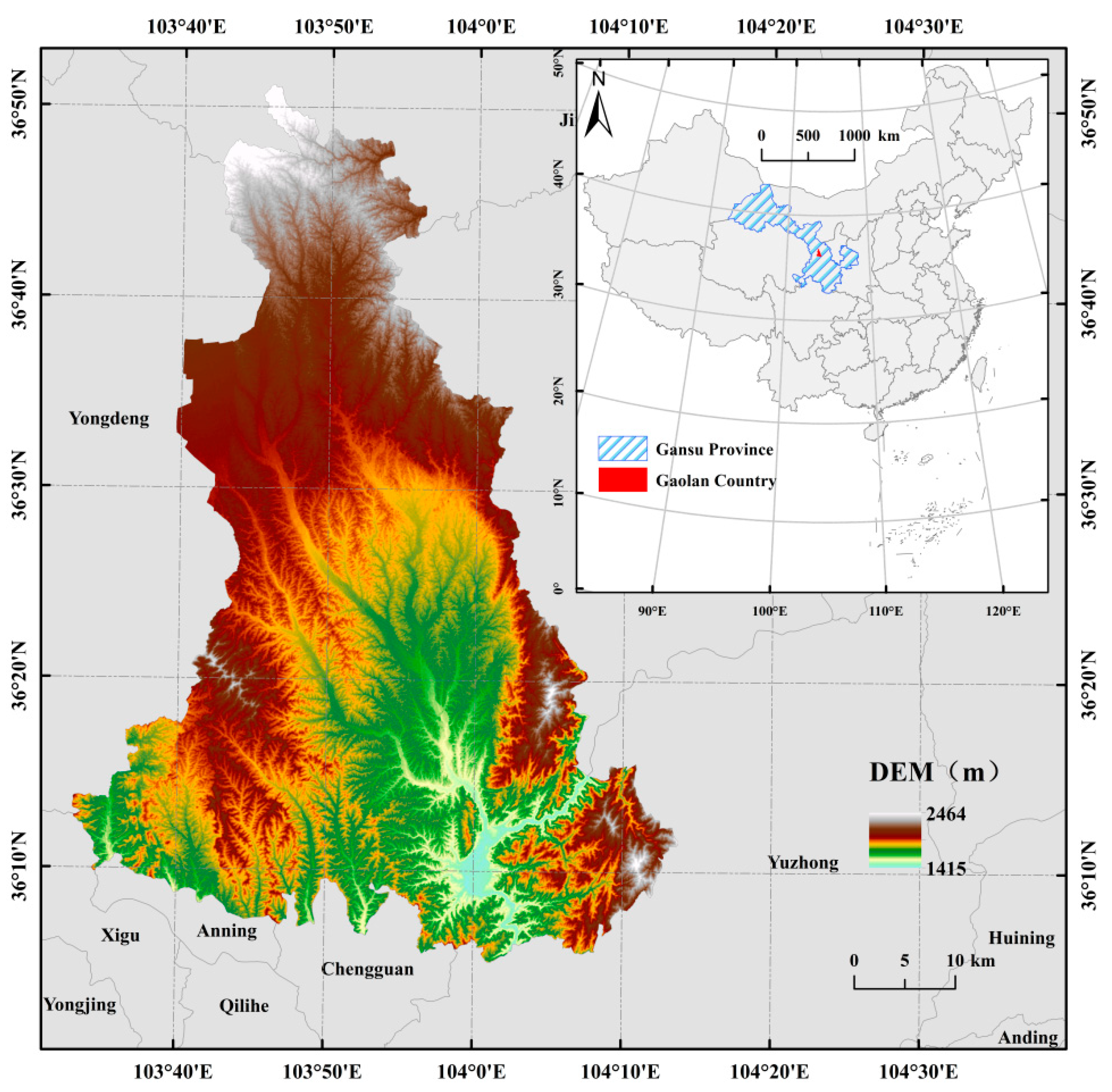
Based on Landsat’s time series image data, this paper uses the random forest classification method to draw abandoned land in the hilly and gully area of China’s Loess Plateau (from 2011 to 2020) by tracking land use trajectories, which provides a reference for drawing abandoned land in other hilly regions in the world. It also analyzes the influencing factors of the difference in the spatial distribution of cultivated land abandonment from the plot scale, in order to provide policy recommendations for decision makers.
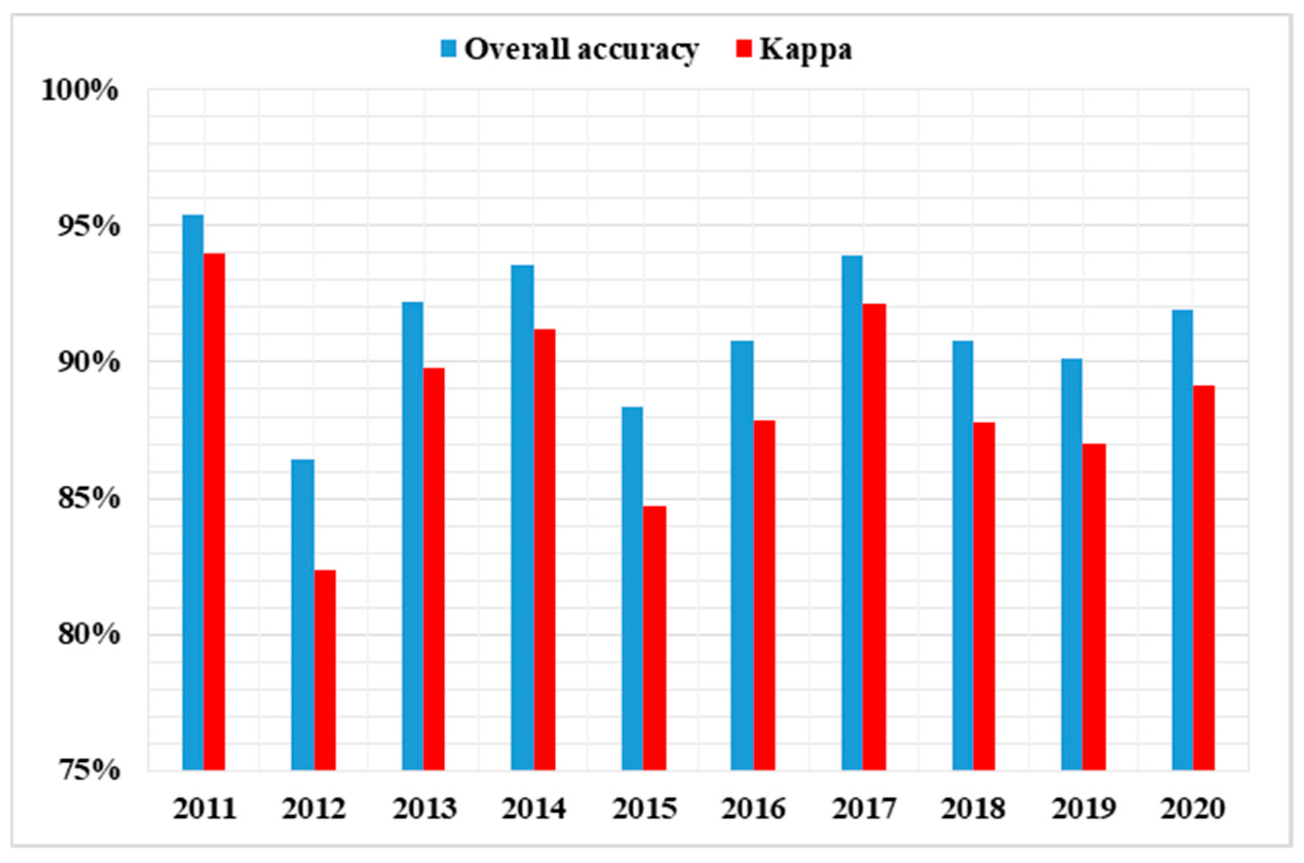
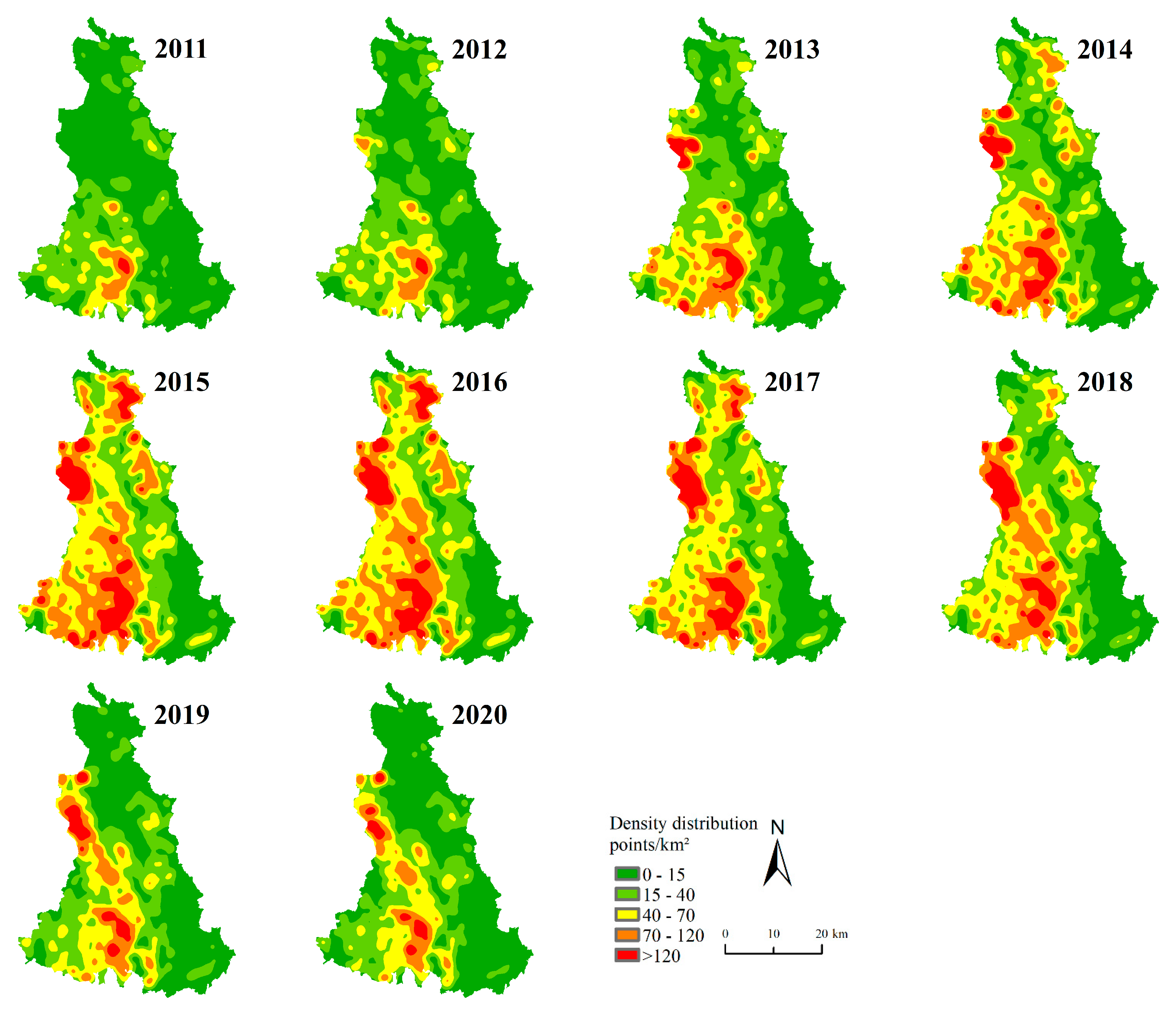
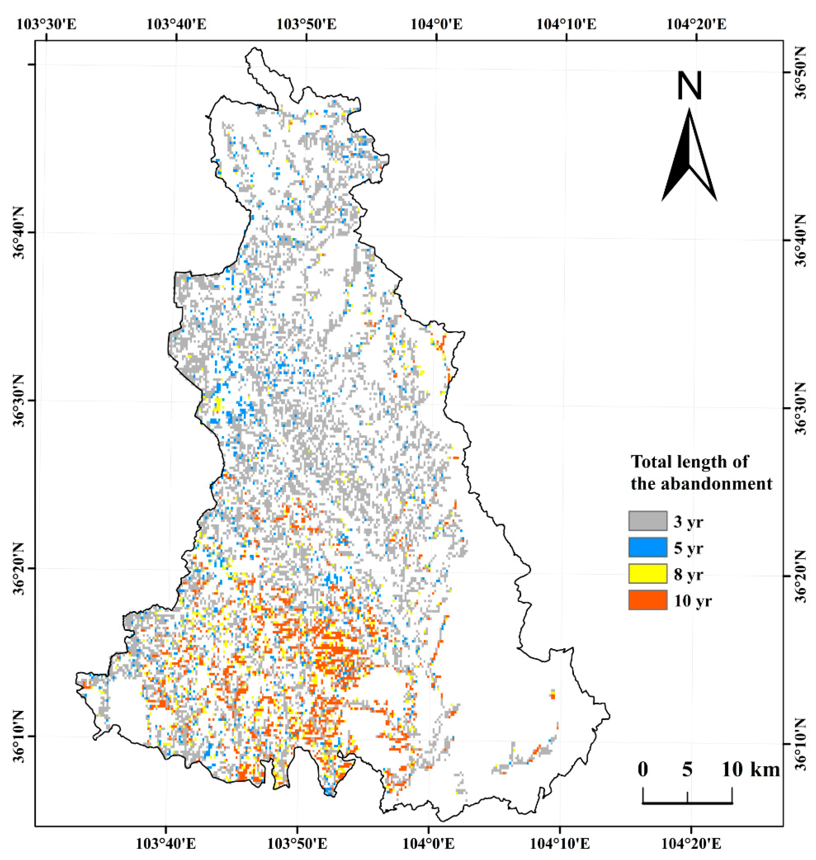
The average accuracy and kappa coefficient of land use classification are 91.35% and 0.88, respectively. The research revealed that the average abandonment rate in Gaolan County was 14.55% from 2013 to 2020, which was serious, and the total area of abandoned cropland was 15,259.04 ha. The abandonment rate first increased and then decreased. In 2015, the abandonment rate was highest; it then decreased year by year. The longest time of abandonment was 10 years and the total time was less than four years for most of the abandoned cropland. The kernel density ranged from 0 to 480 points/km2 and the increase in abandoned areas was mainly manifested in the increased distribution of medium and high-density regions. The People’s Government of Gaolan County has achieved increasingly remarkable results in remediating uncultivated land.
The influencing factors of plot scale can explain the difference in the spatial distribution of abandonment of cultivated land. The slope, soil type and soil fertility factors were selected to analyze their relationship with the abandonment rate. The higher the slope, the less conducive is the land to farming, and the greater the possibility of abandonment. The natural soil, in most areas of Gaolan County, is calcareous soil. Therefore, decision-makers in the hilly and gully areas of the Loess Plateau can encourage farmers to increase vegetation coverage in steep slope areas and consider returning farmland to pasture. On the other hand, we can consider opening up water sources for irrigated farmland to increase crop yields and, at the same time, consider increasing the proportion of leguminous crops, rational crop rotation and fertilization to improve soil fertility.


