1. Introduction
The specific concept of ecological security was first proposed by the United States (U.S.) government, which has drawn considerable attention from the international research community [
1]. Ecological security can also reflect the integrity and health of the ecosystem, which is defined as the comprehensive status of the human ecosystem [
2]. Natural ecosystems provide the materials and services needed for human survival, so maintaining ecosystem security is essential for achieving sustainable socio-economic development [
3].
Sustainability refers to a state or condition that can meet human demands and prevent human activities from damaging the ecosystem [
4]. Rapid socio-economic development, urbanization and industrialization have caused overexploitation of resources, putting huge pressure on the natural ecological environment [
5]. In this sense, human activities and socio-economic development are the main driver of many ecological problems, such as climate change and ecological degradation. As a complex natural and socio-economic ecosystem, land is strongly influenced by natural factors and human activities, and the LES is related to the level of regional sustainable development.
Land ecological security (LES) represents the environment and sustainability of land resources and ecosystems which can provide steady ecological services and meet the ecological needs of future generations [
6,
7]. Since the late 1970s, this idea has received considerable attention from the government and academia [
8]. Numerous studies have focused on empirical research on LES [
9] and the internal relationship between LES and environmental change [
10]. Few international studies have performed direct investigation on LES. The relevant research mainly focused on land sustainability evaluation [
11,
12], land quality evaluation [
13], ecosystem service value evaluation [
14,
15,
16], ecological risk evaluation [
17,
18] and land health [
19,
20]. The research scales were mostly at global, national and regional levels. Since the 1990s, many Chinese researchers have examined four aspects of the LES in China, i.e., the connotation of land ecological security, assessment, early warning and maintenance management [
7,
21,
22]. From the perspective of evaluation, the existing evaluation framework mostly used pressure–state–response (PSR) [
23,
24,
25], drivers–pressure–state–impact–response (DPSIR) [
26], and environment/natural–society–economic (EES/NSE) [
27,
28]. Many evaluation methods have been proposed. Some of them were generic statistical approaches, e.g., the principal component analysis method [
29,
30] and neural network model [
15,
31]. The others were conceptual models, e.g., the comprehensive index method, ecological footprint method [
32,
33], gray correlation method [
34], TOPSIS method [
35,
36,
37,
38,
39], matter-element model [
40] and the positive cloud model method [
41].
The LES exhibits obvious characteristics of spatial heterogeneity and agglomeration, and land protection strategies should be implemented in accordance with the actual conditions in various places [
42]. Previous studies mainly covered provinces [
41,
43], cities [
25], counties [
40,
44], towns [
45] and a few regional economic zones across provinces [
29,
34,
42,
46,
47,
48]. Coordinated development of the BTH region is one of the three major national strategies, and has exemplary significance for the sustainable development of China. The conflict between development and land is significant in this area, with obvious regional differences in land resource endowment and land ecosystem quality [
49]. Many factors (e.g., economic expansion and population growth) have caused environmental degradation, which led to ecological imbalance with a major impact on LES [
50]. Whilst the BTH region has experienced restoration and transformation in recent years, the speed was quite slow [
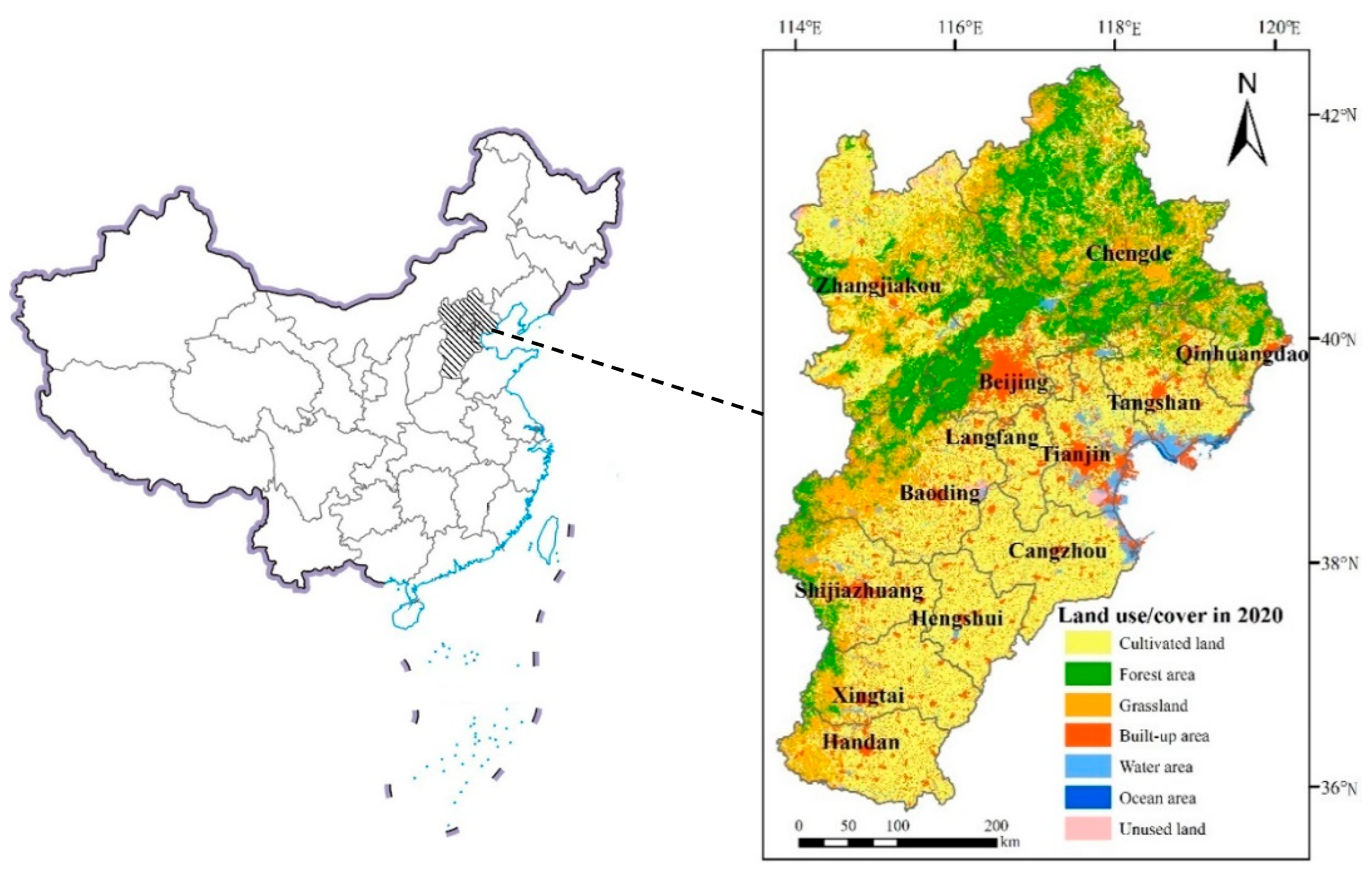
47]. There were limited studies on land ecological security assessment in the BTH region, and little attention has been paid to spatial changes and obstacles in its land ecological security assessment. So, using the BTH region as the research object to perform regional land ecological security assessment is an important foundation for promoting regional sustainable development. With the advancement of coordinated development, this article will discuss the land ecological security status, temporal and spatial changes in the BTH region, and the main obstacles that affect land ecological security.
Based on the collaborative development perspective, this paper performs an LES evaluation on the BTH region. The PSR framework emphasizes the source of environmental pressure, which is the most critical issue in the model framework, because these human activities that cause environmental pressure should be responsible for environmental changes. The coordinated development of Beijing–Tianjin–Hebei requires population, industry, transportation, ecology, etc. Many breakthroughs have been made. Therefore, choosing the PSR framework model to construct a land ecological security evaluation model can better and comprehensively reflect the expressed problems. We establish an evaluation index system based on the PSR model. We apply the entropy method to determine the weight of the evaluation index. The TOPSIS method is adopted to evaluate the LES of the BTH region from 2007 to 2018. In addition, this paper also analyzes the temporal and spatial changes of areas within the BTH region. The obstacle degree model is used to identify the limiting indicator of the LES. This study will provide a theoretical reference of LES for China and even other counties which are experiencing rapid urbanization. It will also offer a scientific basis for making regional land ecological security protection decisions and sustainable development strategies.
4. Discussion
Ecological security is fundamental to the development of human society in the region. Hence, the LES of the BTH region should be taken seriously. Two aspects of the LES are important: (1) structure and function of land resources, and (2) natural resources required for coordinated development. Although previous studies have investigated the land ecological status [
40], population and land ecological pressure [
49,
55,
56] and LES of the BTH region [
44]. There were limited studies on LES from the perspective of coordinated development. Based on the concept of collaborative development, this paper established an evaluation index system, evaluated the state of land ecological security, and performed spatiotemporal analysis and judgment of obstacle degree indicators. Compared to existing studies, this study paid more attention to the impact of the coordinated development strategy on regional LES, and put forward some suggestions for future development in different areas. So far, we have not seen any consistent method for LES assessment. The PSR (pressure–state–response) model is based on the relationship between human society and the environment, and effectively determines the causal relationship between the environmental state and environmental problems. This article attempted to build an evaluation index system under the PSR model from the perspective of collaborative development strategy. Briefly, the pressure (P) and response (R) systems build indicators around “population-industry-transportation-ecology”; and the state (S) builds indicators around “land structure-land function”. The indicator system takes into account the impact of population unraveling, industrial transformation, transportation integration, and ecological protection on LES. In this study, we used the entropy-weighted TOPSIS model to evaluate the LES situation in the BTH region. The TOPSIS model is a multi-objective decision-making method that can better compare the gap between the LES results and the ideal level. In addition, using the entropy-weighted method to determine the weight can reduce the influence of human bias.
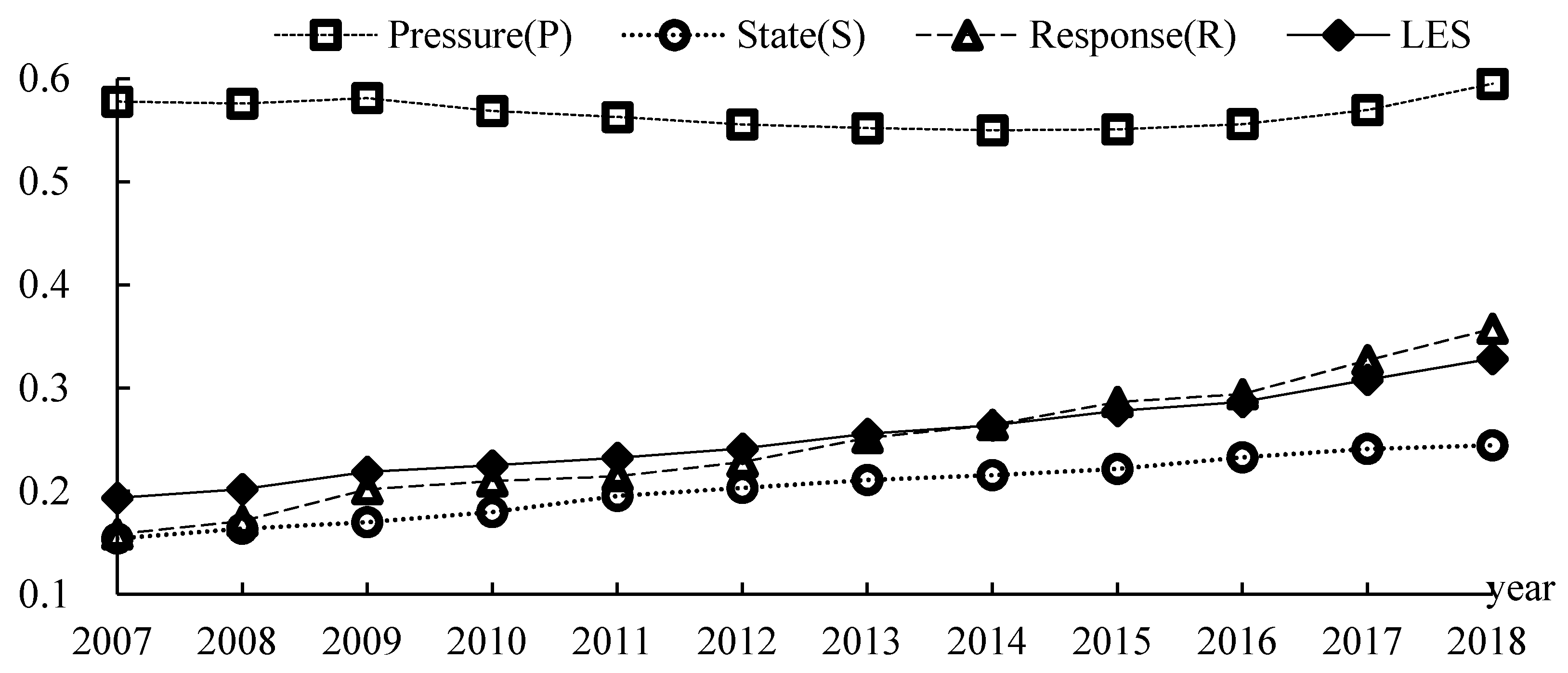
Our results indicate that the LES index has gradually trended upward (from 0.1934 to 0.3284) over the past 12 years. The evaluation results here basically agreed with previous studies. The LES of the land in the BTH region continued to deteriorate from 2000 to 2006 and started to improve from 2007 to 2012. However, the recovery was very slow [
33]. Moreover, this article examined the spatiotemporal changes and determined the obstacle indicators in different areas. This study introduced the obstacle degree model and determined the primary and secondary relationships of the impact indicators by considering the order of the obstacle degree. This can clarify the main obstacle indicators and generate the next policy recommendations. Three strategies can be adopted to improve the LES level of the BTH region. The first strategy is to focus on reducing the ecological pressure on the land; continue to improve the ecological status of the land; actively improve the ecological response of the land; and enhance the overall LES level. The second strategy is to consider the coordinated development background, pay attention to sensitive areas (e.g., Qinhuangdao, Chengde, Zhangjiakou, Baoding, Cangzhou, Hengshui, Xingtai and Handan) according to the functional positioning of each city, support infrastructure and industrial conditions, increase ecological protection, and increase the local LES level. The third strategy is to account for the seven obstacle indicators and adopt corresponding policy measures to address the shortcomings of LES. For example, the constraints of the usage of fertilizer per unit cultivated area can be addressed by cutting the amount of applied fertilizer used; the constraints of cultivated land ratio and tertiary industry ratio can be tackled by increasing the area of cultivated land and green space in built-up areas, and optimizing land structure; the increase in the food production per unit land area can promote the improvement of land functions; the constraints of per capita GDP and tertiary industry ratio can be addressed by supporting infrastructure and improving industrial conditions; the constraints of transportation, warehousing and postal investment per unit land area can be handled by planning the construction of infrastructure (e.g., high-speed rail and subway) and the integration of transportation.
Land ecological security evaluation is an important part of regional ecological security research. The current study utilized prefecture-level cities as evaluation units. Whilst a comparative analysis of the spatial distribution characteristics was performed, the socioeconomic development and land resource endowments of Beijing, Tianjin and Hebei are different. In a future study, we would further analyze the spatial differences between its counties. Furthermore, this was the first attempt to develop an LES indicator system under the background of coordinated development. Given the difficulty of unifying data calibers across provinces and cities, some indicators (e.g., forest land coverage and land tribalization) were excluded in the current study. In a future study, we would combine remote sensing, questionnaires and other methods to improve the indicator system, as well as cover more in-depth research on LES issues.
Sustainable development is currently a hot topic of global concern. In 2015, the United Nations formally adopted “Change Our World: 2030 Agenda for Sustainable Development” and announced 17 global sustainable development goals based on the Millennium Development Goals [
57]. While recognizing the importance of land ecological security in sustainable development, land degradation causing impaired ecosystem functions are costing us USD 6.3 trillion per year of ecosystem service value [
58]. The tropical rainforest in Indonesia has resulted in the loss of biodiversity and ecological functions due to the change of land use types [
59]. Costa Rica’s research has indicated the importance of land cover/use change in the loss of land ecological service functions [
60]. Unreasonable land use can cause land degradation, resulting in the loss of ecological service value and function, and poor land ecological status, which is not conducive to sustainable human development. In the future, a global land ecological security research framework should be constructed. Global or other regional land ecological security evaluation research should be conducted in order to achieve the optimal allocation and sustainable use of global land resources.
5. Conclusions
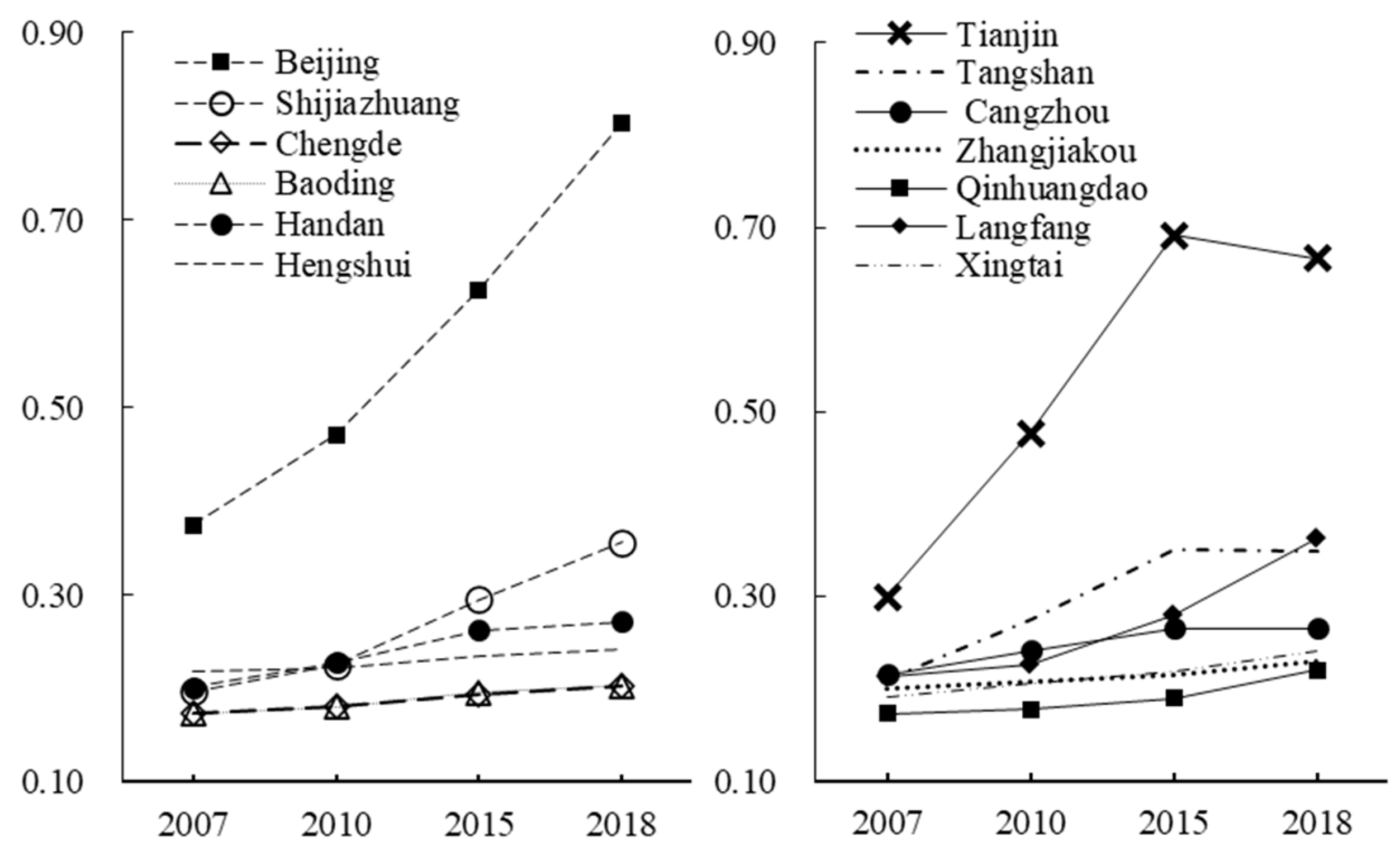
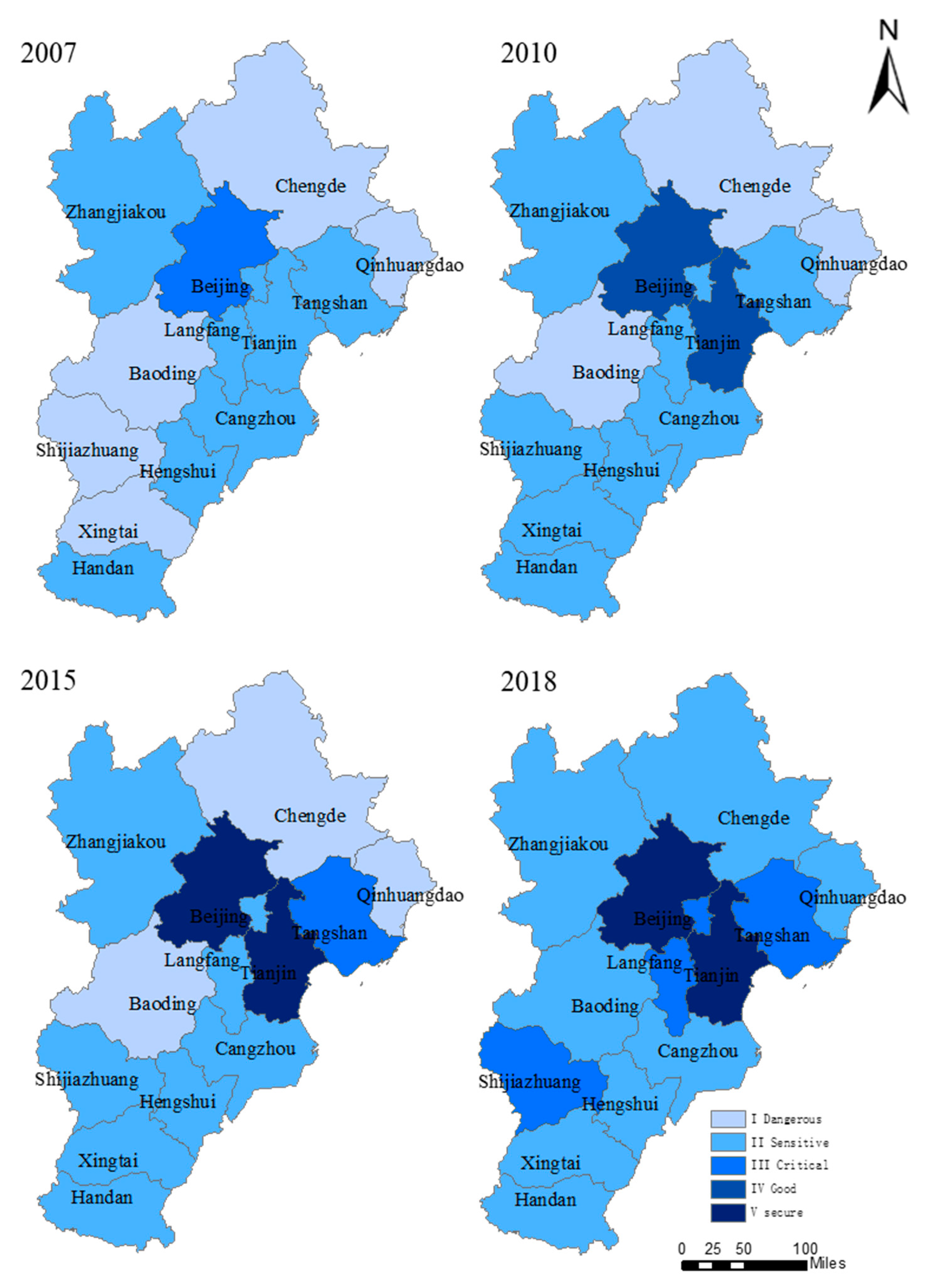
Based on the concept of coordinated development, this study considered the impacts of population, industry, transportation and ecology in order to construct a land ecological security evaluation index system. We used this system to evaluate the LES status of the Beijing–Tianjin–Hebei region from 2007 to 2018. We found that the land ecological security index of Beijing–Tianjin–Hebei region has trended upward (rising from 0.1934 to 0.3284) in the study period. The LES level increased from the dangerous level (I) to the critical level (III). In the study period, the LES status of various areas within the BTH region was generally good, but the trends were different. The LES indices of ten cities (Beijing, Shijiazhuang, Chengde, Zhangjiakou, Qinhuangdao, Langfang, Baoding, Hengshui, Xingtai and Handan) continued to increase. The LES indices of three cities (Tianjin, Tangshan and Cangzhou) increased first and then fell, showing an overall trend of rising fluctuations. The results of different years indicate that there were more sensitive (II) and critical (III) areas, implying that the overall ecological security status of the BTH region was not ideal. In general, the LES level was relatively high in the central area (compared to the northern and southern areas). Despite the satisfactory development of the ecological status of the land in Beijing, Tianjin and Hebei, the risk of deterioration continued to exist. Seven obstacle indicators (i.e., land economic density (D11), transportation, warehousing and postal investment per unit land area (D15), per capita GDP (D13), tertiary industry ratio (D14), cultivated land ratio (D8), the usage of fertilizer per unit cultivated area (D5), and green coverage of urban built-up areas (D9)) have affected the LES in the BTH region.


