
Most Attractive Scenic Sites of the Bulgarian Black Sea Coast: Characterization and Sensitivity to Natural and Human Factors

 ,
,  ,
,  ,
, 
Abstract
:1. Introduction
2. Study Area
3. Methods
- (i)
- A first approximation on the location of the most attractive coastal areas was obtained via land-cover viewers and satellite images, e.g., Google Earth, Copernicus land viewer, etc. The images were used to eliminate urban and village areas, and preselect areas that appeared of great scenic values conforming to the 26 physical and human parameters (Table 1; CSES), e.g., a site which shoreline consists of cliff formations, extensive dunes system and/or shows high vegetation cover and, at the same time, records a low visual impact of human activities. If doubts arose relating the access difficulty or attractiveness, locations were automatically preselected.
- (ii)
- Consequently, 26 sites respectively located in remote areas (17) and rural areas (9), were initially chosen after image viewing, irrespective as to whether they were located or not in protected areas.
- (iii)
- After discussion with local coastal experts and detailed investigation of preselected areas, e.g., by consulting official webs of tourism and location of protected areas, review of published papers and grey literature, etc., a total of 21 locations were selected for field surveying. It should be noted that the criteria used to determine the distribution of preselected sites ranged according to the scenic variety of the shoreline investigated. Selected sites presented the greatest spatial density along heterogeneous scenic shorelines, such as Burgas province (points 1–4, Figure 1), whilst the opposite was true for homogenous scenic shorelines, e.g., Kamchia or Durankulak (points 11 and 15, Figure 1).
- (iv)
- Field surveys were carried out in June 2021 between 10 a.m. and 6 p.m., during normal weather conditions, when stable conditions ruled (e.g., a storm affects water color, point 16 in Table 1) and over beach sectors 400–500 m in length; that is, when a long shoreline is assessed, it can be divided into different 400–500 m sectors. A few preselected sites such as Butamyata (Sinemorets) or Blatoto Alepu (also known as drivers’ beach; Primorsko) were visited but, finally, not chosen, because of their low scenic quality. Cape Emine was finally not assessed because of the very regrettable condition of the access pathway, which required a walk estimated > 1.5 h. When constant alongshore scenic conditions were observed, adjacent sectors were joined together [54,55], giving finally a total of 16 coastal sites with different coastal lengths, from a 62 m in length pocket beach, i.e., Lipite PB (point 2, Figure 1), to a 6770 m long beach, i.e., Durankulak (point 15, Figure 1), and covering a total of c. 32 km, i.e., 8% of the total coastal length of Bulgaria.
- (i)
- Histograms, which provided a visual summary of both physical and human parameters obtained from Table 1 scores;
- (ii)
- A weighted average of attributes, which delineated relative comparison of physical and human parameters;
- (iii)
- Membership degree of attributes, which represented overall scenic assessment over the attributes.
- (i)
- Erosion/flooding processes in a climate change context,
- (ii)
- Unsustainable coastal population and level of development—very often linked to the tourism industry and the lack of management.
- (i)
- During the first phase, sites were classified within three categories according to the presence/absence of the abovementioned parameters (Figure 3);
- (ii)
- (iii)
- In a third phase, forcing variables and predicted changes of sea-level rise and storm surge were used to calculate a Correction Factor (CF, Table 2), since the effects of forcing factors on coastal environments are affected by future variations of those two variables;
- (iv)
- (i)
- In a first phase, according to the level and typology of human pressure, each site was classified within one of the three pre-established categories (Figure 3);
- (ii)
- (iii)
- In a third phase, a Correction Factor (CF, Table 3) for human pressure was established considering trends of tourists and locals at municipality scale;
- (iv)
4. Results and Discussion
4.1. Coastal Scenic Beauty (CSES Method)
4.1.1. Physical Parameters
4.1.2. Anthropogenic Parameters
4.1.3. Analysis and Suggestion Measures
- (a)
- General analysis of Classes I and II
- (1)
- Noise disturbance was non-existent at all investigated sites during field-work observations. However, it should be noted that scores obtained at Veleka (D: 0.79) and Silistar (0.83) could substantially vary during the peak tourist season. Indeed, both sites tend to considerably increase their number of visitors, as they are easily accessible by a <10-min walk and allow for the presence of several beach bars, together with a large number of sunbeds. Many tourists could decrease both sites’ attractiveness to 0.73 and 0.79, respectively.
- (2)
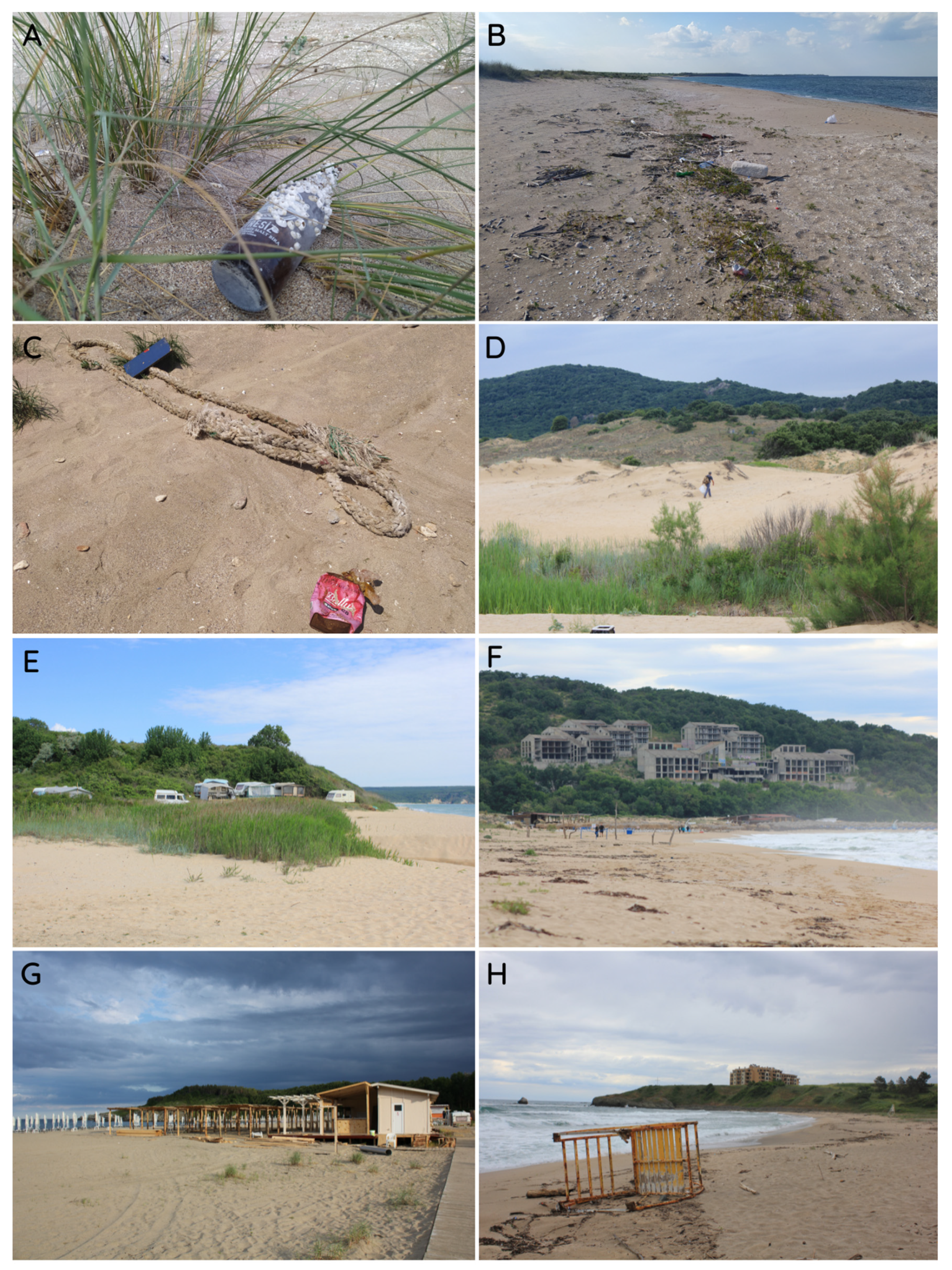
- Litter, linked to discharged items proceeding from different sources, was mainly characterized by single accumulations (rated 3; Table 1 and Figure 6 and Figure 9) and a few scattered items (rated 4). Litter items observed along the study area were mainly stranded by sea currents and rivers, and they were usually composed of plastic items (bottles, bags and cups), glass drinks bottles, fast-food packaging, cans, foamed polystyrene and ship waste (e.g., shipping rope) (Figure 10A–D). Their presence critically lowered a site’s rating. As observed in Andalusia or the Balearic Islands, the absence of periodic cleaning operations is probably due to the difficult access for cleanup machines [38,53]. However, the fact that most items have been lying on the beach for several years constitutes stark evidence of the low interest of competent authorities and managers. Litter has a very large impact on coastal tourism and recreation [63]. As a way of illustrating the relationship between beach litter and its scenic impact, if the current litter rating (3) observed at Lipite PB (D:0.71), Koral (0.67), Vaya PB (0.60), Shabla–Ezerets Lakes (0.75) and Durankulak North (0.72) is upgraded +1, the “D” value of these sites will respectively jump to 0.86, 0.80, 0.74, 0.89 and 0.88. These interventions would upgrade Lipite PB and the two latter to Class I, as well as Vaya PB to Class II. Only at Cap Shabla SP was litter virtually absent.
- (3)
- Sewage was not evident at the sites investigated. Its presence is frequently visible in urban or village beach typologies [57], but hardly ever in remote areas.
- (4)
- Non-Built Environment is the environment as perceived minus its buildings. In the case of Dobrich district, a very agricultural region located in the Northern Bulgaria, fields were relatively close but not visible from the beach, e.g., Durankulak North. All sites gave top scores (5) (Figure 6).
- (5)
- Built Environment refers to surrounding anthropogenic structures, buildings, etc. Sites obtained top values (5), as they were located in the natural environment, except at Koral, where several bungalows are found around the beach (in its northern sector); this was characterized as “sensitive tourism” (rated 4).
- (6)
- Access type usually showed good scores (≥4). Site lower scoring was principally due to four-wheel-drive vehicles that illegally crossed dune systems to get as close as possible to the beach to carry out recreational or fishing activities, among others, i.e., Kamchia, Rakitnika, Durankulak Lakes and Durankulak North. Beyond the scenic impact, this bad practice raises concerns about dunes and beach users’ protection; this critical point is further discussed (cf. sensitivity section). Another curious case is Karadere, where the presence of motor homes and caravans were noticed in the backbeach, due to a lack of camping restrictions (Figure 10E). At Veleka, “Access type” was ticked attribute 4, since an unpaved road was visible from the beach.
- (7)
- Skyline alludes to buildings’ silhouettes not in harmony with the environment. Top grades are frequently related to sites having restricted views, e.g., Vaya and Lipite pocket beaches. Large coastal sectors, as Durankulak Lake, Shabla–Ezerets Lakes or Irakli, located close to sensitively designed human settlements (without high buildings), obtained good scores (4). Kamchia rating (4) was linked to the presence of a 200 m pier emplaced in Shkorpilovtsi village. The worst scores (3) were noticed at Veleka, Arkutino and Koral (Figure 10F,G). The first two are located near the borders of protected areas, while the latter is out of any protected area. In the case of Veleka (D: 0.79; Class II), if the municipality would have not allowed the construction of a few elevated buildings (4 or 5 floors) near the beach rather than traditional houses (with low heights), the “D” value would reach 0.93 (Class I). At Arkutino (D: 0.89), a polemic unfinished resort complex whose construction was abandoned in the late 1980s remains relatively close to the beach (northern sector); without it, Arkutino would be one of the top Bulgarian scenic sites (D: 1.03; without skyline impact).
- (8)
- Utilities is the parameter that covers a large variety of human items, e.g., power lines, lighting, pipelines, seawalls, revetments or temporary leisure facilities, amongst others. Most sites had good scores (4 or 5), except for Silistar and Veleka (rated 1; Figure 6). In both cases, their scenic impact was associated with intrusive structures devoted to seasonal use, i.e., several beach bars, beach umbrellas, first-aid stations and hundreds of sun beds (Figure 10G). This is the perfect illustration of one of the major issues that coastal managers must resolve in “3S” destinations where conflicts arise between scenic preservation and short-term benefits. Such a dilemma was also observed in Andalusia or Balearic Islands, among many other destinations [38,53]. If the administration of Strandzha Nature Park (both sites are in the Strandzha Nature Park) was not so permissive in relation to leisure facilities (but allowing first aid stations), the attractiveness of Silistar (0.83) and Veleka (0.79) could respectively jump to 0.97 and 0.92, upgrading both sites to Class I. At numerous places, lifeguard stations are certainly indispensable because of rip currents, but beach bars and other utilities (sun beds, beach umbrellas, beach kiosk, etc.) should be reduced and/or moved away from the beach, preserving the essence of natural sceneries. Beaches have to be managed according to their typologies and not as a whole. From a management approach, it is not rational that some remotes sites provide the same services as carried out on resort or urban beaches. Finally, at Koral, the presence of two old fallen lifeguard towers gave an attribute rating of 4 (Figure 10H); at Rakitnika, gas pipelines (linked to the offshore Galata Platform) were not considered, as they were not visible from the beach (covered by sand).
4.2. Coastal Scenic Sensitivity (CSSI Method)
4.2.1. Sensitivity to Natural Processes
- (1)
- Dry beach width as a multiple of the ICZ was calculated comparing shorelines for the period 1972–2011, using topographic maps (1:5000) and orthophotos (images from 2019 were only available for Dobrich province). Half of the sites were rated 5, since high recorded erosion rates indicated significant beach width loss (“Dry beach”, Table 6). Sectors such Silistar, Karadere or Vaya PB lost respectively 8.47 m (i.e., a beach width of 40 m), 8.36 m (21.5 m) and 14.48 m (4 m) during the investigated period. Only five, mainly located in the central–northern part of the country, manifested stability or accretion rates (rated 1), i.e., Irakli, Kamchia, Rakitnika, Shabla–Ezerets Lakes and Durankulak Lake (Table 6). The last two abovementioned sites increased their width by 8.62 m and 6.72 m respectively. Two sites, Koral and Durankulak North, gave a rating of 2, as they presented slight erosion rates coupled with values of “Dry beach” >4 times the ICZ (Table 6).
- (2)
- Sediment grain size showed high ratings, since most sites (11) were composed of fine-grained sand (rated 5, Table 6). Four mixed beaches, mainly consisting of sand and, to a lesser extent, pebbles, gravel and/or broken shells, obtained intermediate scores (3) (Table 6). Curious cases were noticed in the northern sectors of Shabla and Durankulak where very impressive accumulations of black shell mussels remained on the beach shoreline (Figure 12A). At these places, reefs constitute the main source of beach material, providing over 90% of sediments [61].
- (3)
- (4)
- Dune parameters, including dune height, width, vegetation cover and washovers, were considered for sites belonging to Category III. Very strong and healthy dune systems that are highly resilient to potential stressing events were recorded at Arkutino and Ropotamo, giving the lowest values (1) for each parameter (Table 6). Low grades were also observed at Kamchia and Koral. However, in the case of Kamchia (and the rest of the northern and central part of the country), the illegal use of vehicles and their associated adverse effects, e.g., fragmentation, loss of vegetation and biodiversity, displacement, compaction, etc., is a very serious issue that beach managers must resolve. For example, at Kamchia and Rakitnika, washover fans, whose formation was favored by this bad practice, broke the dune ridge continuity forming sensitive hot spots to coastal erosion (Figure 12C). At many sites, dune width was also considerably reduced or fragmented by trails parallel to the coast that are mainly used by off-road vehicles, i.e., Kamchia, Shabla–Ezerets Lakes, Durankulak Lake and Durankulak North. To give an instance of effective dune management, a place such as Rakitnika (NSI: 0.66) could improve its general NSI to 0.61 only by reducing washovers <25% and increasing dune width up to 50 m. In the southern part of the country, Veleka’s (NSI: 0.81) and Silistar’s (NSI: 0.84) high scorings were partially associated with the high level of recreational activities and related impacts forming critical gaps in the dune ridge, leading to a loss of vegetation cover and dune width. By mitigating the cumulative effects of pedestrians and beach bars presence, both sites could respectively decrease their sensitivity to 0.75 and 0.77. The real effectiveness of these measures is relative (and probably undervalued), as it is hard to predict how they could influence/reduce the rates of shoreline erosion in future decades. The lowering of the current scores recorded in the first parameter, “Dry Beach as multiple of the ICZ” (rated 5 for both sites, Table 6), would greatly increase the resilience of such coastal features.
- (1)
- Forcing variables include “Wave characteristics” and “Tidal range” parameters. The second was characterized by the highest grade (5) (Table 6), since microtidal coasts are most exposed to potential storm events, as they are always near high tide—a large amount of the literature supports this viewpoint [64,65,66]. Results for “Significant wave height” (Hs) and “Angle of wave approach” were extracted from the Bulgarian National Oceanographic Data Centre [67]. Only three virtual buoys, respectively located in Burgas, Shkorpilovski and Varna, were analyzed during the winter period from October 2020 to March 2021—due to the lack of long time series and scarcity of virtual buoys along the study area—leading to the following values: Varna (Hs: 1.01 m; 90–95°), Shkorpilovski (Hs: 1.14 m; 80–90°) and Burgas (Hs: 0.97 m; 75–85°). Given this context, all sites obtained a rating of 3 for Hs (0.75–1.5 m) (Table 6), whilst the “Angle of wave approach” was judged relating to each site location, varying from 1 to 5, e.g., Ropotamo (1; oblique 40°), Silistar (5; parallel 0°) (Table 6). It should be noted that the Shkorpilovski buoy recorded the highest energy event, with waves reaching around 5.70 m in height in March 2021.
- (2)
- Ongoing changes in RSLR and SS are due to anthropogenic climate change and other factors, and they present a global challenge to coastal managers. It is acknowledged that the Black Sea and its coastal zones are one of the most sensitive areas in Europe at risk for coastal erosion and saltwater intrusion [68]. For European countries, Mean Sea Level (MSL) is expected to reach around 53 cm and 77 cm, under the Representative Concentration Pathways 4.5 and 8.5 (RCP), while projections for the Black Sea give around 59 cm and 80 cm by 2100 [69]. According to Volkov and Landerer [70], the forcing of sea level in the Black Sea is dominated by the basin freshwater budget and water exchange through the Bosporus Strait, as well as depth-integrated changes in seawater density. Many studies have reported that MSL reaches the highest levels during the May–June period [68,70]. RSLR predictions obtained from the LISCOAT database [71] gave a rating of 5 for all investigated sites (Table 6), with values varying from 0.44 (RCP 4.5) to 0.71 (RCP 8.5). Data gaps in tide gauge stations did not allow for estimates of a reliable trend for potential local subsidence effect [68,72]. The storm surge level, defined as the difference between the pure tide and the total water-level simulations, was estimated by using the Copernicus dataset of “Sea level indicators for the European coast from 1977 to 2100” [73]. Based upon past observational data and future climate projections at any regional scale, predictions around 35 cm (for 2100) were recorded for the entire Bulgarian coast; this was reflected by a low scoring (1) (Table 6).
4.2.2. Sensitivity to Human Pressure
- (1)
- Access difficulty is an essential component of management approaches to regulate and protect sites from too many tourists. Among the 16 investigated sectors, only three sites were easily accessible by a <10-min walk from the nearest car park, i.e., Cape Shabla SP (rated 5, Table 7), Rakitnika and Veleka (both rated 4), and eight required a 10–25 min promenade (rated 3). Lower scoring was noticed for Lipite, Irakli, Shabla Ezerets Lakes and Durankulak Lake, which demanded at least 25 min of walking (rated 2, Table 7).
- (2)
- Protected Area Management Category was assessed accordingly to the standard methodology provided by the International Union for Conservation of Nature (IUCN) [75], ranging from protected areas very strictly managed, e.g., Ropotamo Strict Nature Reserve (Ia), to ones managed in a relatively permissive way, e.g., Silistar Protected Area (VI). As shown in Table 5, sectors were partially or completely covered by several national and international designations, e.g., Nature Parks, Natura 2000, apart from Koral beach (rated 5, Table 7). All sites belonged to the Natura 2000 network characterized by 26 Marine Protected Areas (MPAs), with most including a coastal land area with only a narrow strip protruding into the sea, 11 SPAs (under the Birds Directive), 13 SCIs (under Habitats Directives) and two SCI–SPAs under both directives [51]. However, the practical application of Natura 2000 still poses major problems, since its process of implementation is coordinated and managed by the Ministry of Environment and Water, while CDDA (Nationally designated areas) is managed by different Institutions. Today, there is still a lack of approved and operational management plans for coastal protected areas and MPAs [51]. Because of a lower grade of protection, sites located within State Game Husbandries combined with MPAs obtained a rating of 4, i.e., Vaya PB, Arkutino or Cape Shabla (Table 7), whilst sites within a Nature Park (Category V, IUCN), i.e., Strandzha, Protected Area/Site (VI), e.g., Silistar, Veleka and Shablensko Ezero, gave intermediated values (3) (Table 7). At Kamchia (rated 4), the eponymous Protected Site (VI) and Strict Nature Reserve (Ia) (Table 5), were not considered, as they only related to the river outlet and not the beach. Irakli is a similar case, as a Natural Monument area (III) situated along the southern sector was not reflected in its rating (3), since it only represents a minor part of the total beach length.
- (3)
- Tourism Intensity Rate (TIR) and Population Density (PD) were evaluated by using the dataset provided by the Ministry of Tourism [76] and the National Statistical Institute [77] (2021), both at municipality scale (Nomenclature of Territorial Units for Statistics, NUTS 5), given that provincial averages bear the risk of misleading disparities. Top grades for TIR (5) were registered at several municipalities (Table 7), suggesting that tourist capacity is superior to that of the permanent population. Highest values were noticed at Primorsko, i.e., 4346 tourist beds per 1000 inhabitants (2020), Nessebar (3216 beds per 1000 inhabitants), Tsarevo (1757 beds) and Byala (1088 beds), whilst Avren and Varna showed the lowest ratings (<30% beds per inhabitants; rated 2, Table 7). However, an opposite trend was recorded for PD. Bulgaria is experiencing a decline in population, which began at the beginning of the 1990s, and currently is losing roughly around 50,000 citizens per year [78], this being one of the major issues/challenges that the governing authority has to deal with. With regard to coastal municipalities, low values were commonly observed (≤2), except at Varna (1438 inhabitants/km2; rated 5, Table 7) and, to a lesser extent, at Dolni Chiflik, with 152 inhabitants per km2 (rated 3, Table 7). Lastly, in the case of Kamchia and Rakitnika, since both sectors belonged to two different municipalities, the highest values obtained for the TIR and PD were chosen for the HI assessment.
- (1)
- Evolution of tourist beds, obtained from the Ministry of Tourism [76], was generally characterized by high values (≥4) for most sites (Table 7). Only two municipalities presented lower scores, respectively, Dolni Chiflik (rated 3, Table 7), with an increase of 44% during the period 2006–2021, and Varna, which stands out from the rest with a 10% decrease (rated 1, Table 7). Opposite results were noticed at Shabla and Byala, both rated 5, with, respectively, an increase of 588% (538 in 2006, and 3702 in 2021) and 434% (from 292 to 1561).
- (2)
- Evolution of the resident population was also considered to complement the latter variable, since a decrease/increase of the resident population can also have a significant impact on coastal areas. In this case, and considering the current Bulgarian situation, a stable evolution was reflected by intermediate scores (3), whereas an increase >25% obtained the top rating (5), and vice versa, for a decrease >25% (1) (Table 7). The municipality of Nessebar (rated 5) recorded a 42% rise in inhabitants from 2005 (20,938) to 2020 (29,814) [77]. A slight increase was also registered at Varna (rated 4, Table 7). The lowest rate corresponded to Shabla, which showed a 27% decrease, with 5959 inhabitants in 2005 and 4337 in 2020. Finally, Tsarevo, Primorsko and Byala municipalities maintained a stable population in the last 15 years (rated 3, Table 7).
4.3. Beauty versus Sensitivity: Priorities in Terms of Management
4.3.1. NSI versus “D” Value
4.3.2. HSI versus “D” Value
5. Conclusions
- (i)
- The characterization of most attractive coastal scenic sites and associated weakness and sensitivity to natural and human induced factors,
- (ii)
- The promotion of their potential development under ecotourism principles.
Author Contributions
Funding
Acknowledgments
Conflicts of Interest
Appendix A

| Indexes and Categories | Equations | Parameters |
|---|---|---|
| Erodibility Index (1) for Category II sites (EIC2) | : erodibility of beach face parameters natural parameter dry beach evolution sediment grain size Pn3a: rocky shore width Pn3b: rocky shore location : number of natural parameters (3) A: maximum attribute value (5) | |
| Erodibility Index (2) for Category III sites (EIC3) | : erodibility of dune system parameters | |
| Erodibility of dune system (3) (EDS) | : dune height dune width Pn6: vegetation cover Pn7: washovers | |
| Natural Correction Factor (4) (CFN) | c1a: significant wave height c1b: angle of wave approach : tidal range c3: sea-level rise c4: storm surge | |
| Natural Sensitivity Index (5) (NSI) | ||
| Human Impact Index (6) for Category II sites (HIC2) | Ph: human parameter : access difficulty Ph2: protected area management category Ph3a: tourism intensity rate : population density : number of human parameters A: maximum attribute value (5) | |
| Human Impact Index (7) for Category III sites (HIC3) | : beach typology | |
| Human Correction Factor (8) (CFH) | : tourism trend : population trend | |
| Human Sensitivity Index (9) (HSI) | ||
| Total Sensitivity Index (10) (TSI) | ||
References
- Carter, R.W.G. Coastal Environments; Academic Press: Cambridge, MA, USA, 1988; p. 617. [Google Scholar]
- Reid, W.V.; Mooney, H.A.; Cropper, A.; Capistrano, D.; Carpenter, S.R.; Chopra, K.; Dasgupta, P.; Dietz, T.; Duraiappah, A.K.; Hassan, R.; et al. Ecosystems and Human Well–Being—Synthesis: A Report of the Millennium Ecosystem Assessment; Island Press: Washington, DC, USA, 2005. [Google Scholar]
- Maes, J.; Teller, A.; Erhard, M.; Liquete, C.; Braat, L.; Berry, P.; Egoh, B.; Puydarrieux, P.; Fiorina, C.; Santos, F.; et al. Mapping and Assessment of Ecosystems and Their Services. In An Analytical Framework for Ecosystem Assessments under Action 5 of the EU Biodiversity Strategy to 2020; Publications Office of the European Union: Luxembourg, 2013; pp. 1–58. [Google Scholar]
- Fabbri, P. (Ed.) Recreational Uses of Coastal Areas: A Research Project of the Commission on the Coastal Environment, International Geographical Union; The GeoJournal Library; Springer: Dordrecht, The Netherlands, 1990; Volume 12, p. 287. [Google Scholar] [CrossRef]
- Hughes, Z.; Duchain, H. Tourism and climate impact on the North American Eastern sea-board. In Disappearing Destinations: Climate Change and Future Challenges for Coastal Tourism; Jones, A., Phillips, M.R., Eds.; CABI: Oxford, UK, 2011; pp. 161–176. [Google Scholar]
- Pranzini, E.; Wetzel, L.; Williams, A.T. Conclusions. In Coastal Erosion and Protection in Europe; Pranzini, E., Williams, A.T., Eds.; Routledge/Earthscan: London, UK, 2013; pp. 427–445. [Google Scholar]
- Pilkey, O.H.; Cooper, J.A. The Last Beach; Duke University Press: Durham, UK, 2014. [Google Scholar]
- EC (European Commission). Study on Specific Challenges for a Sustainable Development of Coastal and Maritime Tourism in Europe; Final Report; EC (European Commission): Luxembourg, 2016. [Google Scholar]
- Williams, A.T.; Rangel-Buitrago, N.; Pranzini, E.; Anfuso, G. The management of coastal erosion. Ocean Coast. Manag. 2018, 156, 4–20. [Google Scholar] [CrossRef]
- Molina, R.; Anfuso, G.; Manno, G.; Gracia, F.J. The Mediterranean Coast of Andalusia (Spain): Medium-Term Evolution and Impacts of Coastal Structures. Sustainability 2019, 11, 3539. [Google Scholar] [CrossRef] [Green Version]
- Anthony, E.; Sabatier, F. Coastal Stabilization Practice in France. In Pitfalls of Shoreline Stabilization; Coastal Research Library; Cooper, J., Pilkey, O., Eds.; Springer: Dordrecht, The Netherlands, 2012; Volume 3, pp. 303–321. [Google Scholar]
- Santos, V.M.; Haigh, I.D.; Wahl, T. Spatial and Temporal Clustering Analysis of Extreme Wave Events around the UK Coastline. J. Mar. Sci. Eng. 2017, 5, 28. [Google Scholar] [CrossRef]
- Anfuso, G.; Loureiro, C.; Taaouati, M.; Smyth, T.; Jackson, D. Spatial Variability of Beach Impact from Post-Tropical Cyclone Katia (2011) on Northern Ireland’s North Coast. Water 2020, 12, 1380. [Google Scholar] [CrossRef]
- Lozano, I.; Devoy, R.; May, W.; Andersen, U. Storminess and vulnerability along the Atlantic coastlines of Europe: Analysis of storm records and of a greenhouse gases induced climate scenario. Mar. Geol. 2004, 210, 205–225. [Google Scholar] [CrossRef]
- Komar, P.D.; Allan, J.C. Increasing hurricane-generated wave heights along the US East Coast and their climate controls. J. Coast. Res. 2008, 24, 479–488. [Google Scholar] [CrossRef]
- Beudin, A.; Ganju, N.K.; Defne, Z.; Aretxabaleta, A. Physical response of a back-barrier estuary to a post-tropical cyclone. J. Geophys. Res. Ocean. 2017, 122, 5888–5904. [Google Scholar] [CrossRef] [Green Version]
- Bird, E. Coastal Geomorphology: An Introduction; John Wiley & Sons: Hoboken, NJ, USA, 2011. [Google Scholar]
- Nicholls, R.J.; Hoozemans, F.M.; Marchand, M. Increasing flood risk and wetland losses due to global sea-level rise: Regional and global analyses. Glob. Environ. Chang. 1999, 9, S69–S87. [Google Scholar] [CrossRef]
- Kulp, S.A.; Strauss, B.H. New elevation data triple estimates of global vulnerability to sea-level rise and coastal flooding. Nat. Commun. 2019, 10, 1–12. [Google Scholar]
- Lincke, D.; Hinkel, J. Coastal Migration due to 21st Century Sea-Level Rise. Earth’s Future 2021, 9, e2020EF001965. [Google Scholar] [CrossRef]
- Mir Gual, M.; Pons, G.X.; Martín Prieto, J.A.; Rodríguez Perea, A. A critical view of the blue flag beaches in Spain using environmental variables. Ocean Coast. Manag. 2015, 105, 106–115. [Google Scholar] [CrossRef]
- Semeoshenkova, V.; Newton, A. Overview of erosion and beach quality issues in three southern European countries: Portugal, Spain and Italy. Ocean Coast. Manag. 2016, 118, 12–21. [Google Scholar] [CrossRef]
- Anfuso, G.; Williams, A.T.; Martínez, G.C.; Botero, C.; Hernández, J.C.; Pranzini, E. Evaluation of the scenic value of 100 beaches in Cuba: Implications for coastal tourism management. Ocean Coast. Manag. 2017, 142, 173–185. [Google Scholar] [CrossRef]
- European Environement Agency. The Millennium Ecosystem Assessment. Available online: https://www.eea.europa.eu/policy-documents/the-millennium-ecosystem-assessment (accessed on 22 July 2020).
- Cinelli, I.; Anfuso, G.; Privitera, S.; Pranzini, E. An Overview on Railway Impacts on Coastal Environment and Beach Tourism in Sicily (Italy). Sustainability 2021, 13, 7068. [Google Scholar] [CrossRef]
- Doody, J.P. “Coastal squeeze” an historical perspective. J. Coast. Conserv. 2004, 10, 129–138. [Google Scholar] [CrossRef]
- Martínez, M.L.; Mendoza-Gonzalez, G.; Silva, R.; Mendoza, E. Land use changes and sea level rise may induce a “coastal squeeze” on the coasts of Veracruz, Mexico. Glob. Environ. Chang. 2014, 29, 180–188. [Google Scholar] [CrossRef]
- Neumann, B.; Vafeidis, A.T.; Zimmermann, J.; Nicholls, R.J. Future coastal population growth and exposure to sea-level rise and coastal flooding-a global assessment. PLoS ONE 2015, 10, e0118571. [Google Scholar] [CrossRef] [PubMed] [Green Version]
- European Environmental Agency. The Changing Faces of Europe’s Coastal Areas; Office for Official Publications of the European Communities: Bruxelles, Belgium, 2006.
- Claudet, J.; Fraschetti, S. Human-driven impacts on marine habitats: A regional meta-analysis in the Mediterranean Sea. Biol. Conserv. 2010, 143, 2195–2206. [Google Scholar] [CrossRef]
- UNWTO (United Nations World Tourism Organization). UNWTO World Tourism Barometer and Statistical Annex, Jan 2020. Barom 2020, 18, 1–6. [Google Scholar]
- Honey, M.; Krantz, D. Global Trends in Coastal Tourism; Center on Ecotourism and Sustainable Development: Washington, DC, USA, 2007. [Google Scholar]
- Williams, A.T.; Micallef, A. Beach Management: Principles and Practices; Earthscan: London, UK, 2009; p. 480. [Google Scholar]
- Williams, A.T. Definitions and typologies of coastal tourism beach destinations. In Disappearing Destinations: Climate Change and Future Challenges for Coastal Tourism; Jones, A., Phillips, M., Eds.; CABI: Wallingford, UK, 2011; p. 296. [Google Scholar]
- Houston, J.R. The Economic Value of Beaches a 2013 Update. Available online: https://www.researchgate.net/publication/284772036_The_economic_value_of_beaches_a_2013_update (accessed on 1 December 2021).
- Council of Europe. European Landscape Convention; Council of Europe: Florence, Italy, 2000. [Google Scholar]
- Mooser, A.; Anfuso, G.; Williams, A.T.; Molina, R.; Aucelli, P.P.C. An Innovative Approach to Determine Coastal Scenic Beauty and Sensitivity in a Scenario of Increasing Human Pressure and Natural Impacts due to Climate Change. Water 2021, 13, 49. [Google Scholar] [CrossRef]
- Mooser, A.; Anfuso, G.; Gómez-Pujol, L.; Rizzo, A.; Williams, A.T.; Aucelli, P.P.C. Coastal Scenic Beauty and Sensitivity at the Balearic Islands, Spain: Implication of Natural and Human Factors. Land 2021, 10, 456. [Google Scholar] [CrossRef]
- Ergin, A.; Karaesmen, E.; Micallef, A.; Williams, A.T. A new methodology for evaluating coastal scenery: Fuzzy logic systems. Area 2004, 36, 367–386. [Google Scholar] [CrossRef]
- Ergin, A.; Williams, A.T.; Micallef, A. Coastal scenery: Appreciation and evaluation. J. Coast. Res. 2006, 22, 958–964. [Google Scholar] [CrossRef]
- Ergin, A. Coastal Scenery Assessment by Means of a Fuzzy Logic Approach. In Coastal Scenery: Evaluation and Management; Rangel-Buitrago, N., Ed.; Springer: Dordrecht, The Netherlands, 2019; pp. 67–106. [Google Scholar]
- UNWTO (United Nations World Tourism Organization). Tourism Highlights; UNWTO: Madrid, Spain, 2019. [Google Scholar]
- Stanchev, H.; Young, R.; Stancheva, M. Integrating GIS and high-resolution orthophoto images for the development of a geomorphic shoreline classification and risk assessment—A case study of cliff/bluff erosion along the Bulgarian coast. J. Coast. Conserv. 2013, 17, 719–728. [Google Scholar] [CrossRef]
- Stancheva, M. Bulgaria. In Coastal Erosion and Protection in Europe; Pranzini, E., Williams, A., Eds.; Routledge: Abingdon, UK, 2013; pp. 378–395. [Google Scholar]
- Pashova, L.; Yovev, I. Geodetic studies of the influence of climate change on the Black Sea level trend. J. Environ. Prot. Ecol. 2010, 11, 791–801. [Google Scholar]
- Palazov, A.; Stanchev, H. Risk for the population along the Bulgarian Back Sea Coast from Flooding caused by Extreme Rise of Sea Level. Inf. Secur. Int. J. 2009, 24, 65–75. [Google Scholar]
- Stancheva, M.; Ratas, U.; Orviku, K.; Palazov, A.; Rivis, R.; Kont, A.; Peychev, V.; Tonisson, H.; Stanchev, H. Sand dune destruction due to increased human impacts along the Bulgarian Black Sea coasts. J. Coast. Res. 2011, 64, 324–328. [Google Scholar]
- National Statistical Institute (NSI). Regions, Districts and Municipalities in the Republic of Bulgaria 2011 (in Bulgarian). Available online: www.nsi.bg (accessed on 16 November 2021).
- Stanchev, H.; Stancheva, M.; Young, R. Implications of population and tourism development growth for Bulgarian coastal zone. J. Coast. Conserv. 2015, 19, 59–72. [Google Scholar] [CrossRef]
- EC (European Commission). The EU Blue Economy Report 2019; Publications Office of the European Union: Luxembourg, 2019. [Google Scholar]
- Stancheva, M.; Stanchev, H.; Peev, P.; Anfuso, G.; Williams, A.T. Coastal protected areas and historical sites in North—Challenges, mismanagement and future perspectives. Ocean Coast. Manag. 2016, 130, 340–354. [Google Scholar] [CrossRef]
- Peev, P.; Farr, R.H.; Slavchev, V.; Grant, M.J.; Adams, J.; Bailey, G. Bulgaria: Sea-Level Change and Submerged Settlements on the Black Sea. In The Archaeology of Europe’s Drowned Landscapes; Bailey, G., Galanidou, N., Peeters, H., Jöns, H., Mennenga, M., Eds.; Coastal Research Library, Springer: Cham, Switzerland, 2020; Volume 35. [Google Scholar] [CrossRef] [Green Version]
- Mooser, A.; Anfuso, G.; Mestanza, C.; Williams, A.T. Management Implications for the Most Attractive Scenic Sites along the Andalusia Coast (SW Spain). Sustainability 2018, 10, 1328. [Google Scholar] [CrossRef] [Green Version]
- Cristiano, S.; Rockett, G.; Portz, L.; Anfuso, G.; Gruber, N.; Williams, A.T. Evaluation of coastal scenery in urban beaches: Torres, Rio Grande do Sul, Brazil. JICZM 2016, 16, 71–78. [Google Scholar]
- Alcérreca-Huerta, J.C.; Montiel-Hernández, J.R.; Callejas-Jiménez, M.E.; Hernández-Avilés, D.A.; Anfuso, G.; Silva, R. Vulnerability of Subaerial and Submarine Landscapes: The Sand Falls in Cabo San Lucas, Mexico. Land 2021, 10, 27. [Google Scholar] [CrossRef]
- Patel, A. Analytical structures and analysis of fuzzy PD controllers with multifuzzy sets having variable cross-point level. Fuzzy Sets Syst. 2002, 129, 311–334. [Google Scholar] [CrossRef]
- Anfuso, G.; Williams, A.T.; Rangel-Buitrago, N. Examples of Class Divisions and Country Synopsis for Coastal Scenic Evaluations. In Coastal Scenery; Springer: Berlin/Heidelberg, Germany, 2019; pp. 143–210. [Google Scholar]
- Ministry of Environment and Waters. Strandja Nature Park. Available online: https://www.strandja.bg/en/info/40-organizacionna-struktura-i-administracia-en (accessed on 24 November 2021).
- Stancheva, M. Sand dunes along the Bulgarian Black Sea coast. Compt. Rend. Acad. Bulg. Sci. 2010, 63, 1037–1048. [Google Scholar]
- Stancheva, M.; Stanchev, H.; Palazov, A.; Young, R. Coastal dune changes under natural/human hazards. In Proceedings of the 12th International Conference on the Mediterranean Coastal Environment, MEDCOAST 15, Varna, Bulgaria, 6–10 October 2015. [Google Scholar]
- Dachev, V.Z.; Trifonova, E.V.; Stancheva, M. Monitoring of the Bulgarian Black Sea Beaches. In Maritime Transportation and Exploitation of Ocean and Coastal Resources; Soares, C.G., Garbatov, Y., Fonseca, N., Eds.; Taylor & Francis Group/Balkema: Leiden, The Netherlands, 2005; pp. 1411–1416. [Google Scholar]
- Sotirov, A. Division of the Bulgarian Black Sea coast according the type of the beach sands and their supplying provinces. Rev. Bulg. Geol. Soc. 2003, 64, 39–43. [Google Scholar]
- Botero, C.M.; Anfuso, G.; Milanes, C.; Cabrera, A.; Casas, G.; Pranzini, E.; Williams, A.T. Litter assessment on 99 Cuban beaches: A baseline to identify sources of pollution and impacts for tourism and recreation. Mar. Pollut. Bull. 2017, 122, 47–64. [Google Scholar] [CrossRef] [PubMed]
- Thieler, E.R.; Hammar-Klose, E.S. National Assessment of Coastal Vulnerability to Future Sea-Level Rise: Preliminary Results for the U.S. Pacific Coast. USGS. 2000; Fact Sheet 076-00. Available online: https://pubs.usgs.gov/dds/dds68/reports/westrep.pdf (accessed on 28 December 2020).
- Pendleton, E.A.; Thieler, E.R.; Williams, S.J.; Beavers, R.S. Coastal Vulnerability Assessment of Padre Island National Seashore (PAIS) to Sea-Level Rise. USGS Rep. 2004; Open File Report 2004–1090. Available online: https://pubs.usgs.gov/of/2004/1090/ (accessed on 15 November 2020). [CrossRef] [Green Version]
- McLaughlin, S.; Cooper, J. A multi-scale coastal vulnerability index: A tool for coastal managers? Environ. Hazards 2010, 9, 233–248. [Google Scholar] [CrossRef]
- Bulgarian National Oceanographic Data Centre. Available online: http://bgodc.io-bas.bg/ (accessed on 24 November 2021).
- Avşar, N.B.; Kutoğlu, Ş.H. Recent Sea Level Change in the Black Sea from Satellite Altimetry and Tide Gauge Observations. ISPRS Int. J. Geo-Inf. 2020, 9, 185. [Google Scholar] [CrossRef] [Green Version]
- Vousdoukas, M.; Voukouvalas, E.; Annunziato, A.; Giardino, A.; Feyen, L. Projections of extreme storm surge levels along Europe. Clim. Dyn. 2016, 47, 3171–3190. [Google Scholar] [CrossRef] [Green Version]
- Volkov, D.L.; Landerer, F.W. Internal and external forcing of sea level variability in the Black Sea. Clim. Dyn. 2015, 45, 2633–2646. [Google Scholar] [CrossRef]
- EC (European Commission). Large Scale Integrated Sea-level and Coastal Assessment Tool, JRC Data Catalogue. Available online: http://data.jrc.ec.europa.eu/collection/LISCOAST (accessed on 17 October 2021).
- Pashova, L. Assessment of the sea level change on different timescales from varna and burgas tide gauge data. CR Acad. Bulg. Sci. 2012, 65, 193–202. [Google Scholar]
- CDS—Copernicus Data Store. Available online: https://cds.climate.copernicus.eu/portfolio/dataset/sis-water-level-change-indicators (accessed on 10 October 2021).
- Botero, C.; Anfuso, G.; Duarte, D.; Palacios, A.; Williams, A.T. Perception of coastal scenery along the Caribbean littoral of Colombia. J. Coast. Res. 2013, 65, 1733–1738. [Google Scholar] [CrossRef]
- Dudley, N. (Ed.) Guidelines for Applying Protected Area Management Categories; IUCN: Gland, Switzerland, 2008; Available online: https://portals.iucn.org/library/sites/library/files/documents/PAG-021.pdf (accessed on 5 October 2021). [CrossRef] [Green Version]
- Ministry of Tourism. National Tourist Register. Available online: https://ntr.tourism.government.bg/CategoryzationAll.nsf/mn.xsp (accessed on 23 November 2021).
- National Statistical Institute (NSI). Population by Districts, Municipalities, Place of Residence and Sex. Available online: https://www.nsi.bg (accessed on 23 November 2021).
- United Nations. Department of Economic and Social Affairs, World Population Prospects 2019. Available online: https://population.un.org/wpp/ (accessed on 18 November 2021).
- Ecotour-net. Ecotourism in Black Sea. Available online: https://ecotournet.net/ (accessed on 4 December 2021).
- North Devon Coast AONB. Area of Outstanding Natural Beauty Management Plan 2019–2024; The North Devon Coast AONB: Devon, UK, 2019; Available online: https://www.northdevon-aonb.org.uk/about/management-plan-2019-2024 (accessed on 4 December 2021).


| No. | Physical Parameters | Weight | Rating | |||||
|---|---|---|---|---|---|---|---|---|
| 1 | 2 | 3 | 4 | 5 | ||||
| 1 | Height (m) | 0.02 | Absent | 5 ≤ H < 30 | 30 ≤ H < 60 | 60 ≤ H < 90 | H ≥ 90 | |
| 2 | CLIFF | Slope | 0.02 | <45° | 45–60° | 60–75° | 75–85° | circa vertical |
| 3 | Features * | 0.03 | Absent | 1 | 2 | 3 | Many (>3) | |
| 4 | Type | 0.03 | Absent | Mud | Cobble/Boulder | Pebble/Gravel | Sand | |
| 5 | BEACH FACE | Width (m) | 0.03 | Absent | W < 5 or W > 100 | 5 ≤ W < 25 | 25 ≤ W < 50 | 50 ≤ W ≤ 100 |
| 6 | Color | 0.02 | Absent | Dark | Dark tan | Light tan/bleached | White/gold | |
| 7 | Slope | 0.01 | Absent | <5° | 5–10° | 10–20° | 20–45° | |
| 8 | ROCKY SHORE | Extent | 0.01 | Absent | <5 m | 5–10 m | 10–20 m | >20 m |
| 9 | Roughness | 0.02 | Absent | Distinctly jagged | Deeply pitted and/or irregular | Shallow pitted | Smooth | |
| 10 | DUNES | 0.04 | Absent | Remnants | Fore-dune | Secondary ridge | Several | |
| 11 | VALLEY | 0.08 | Absent | Dry valley | (<1 m) Stream | (1–4 m) Stream | River/limestone gorge | |
| 12 | SKYLINE LANDFORM | 0.08 | Not visible | Flat | Undulating | Highly undulating | Mountainous | |
| 13 | TIDES | 0.04 | Macro (>4 m) | Meso (2–4 m) | Micro (<2 m) | |||
| 14 | COASTAL LANDSCAPE FEATURES ** | 0.12 | None | 1 | 2 | 3 | >3 | |
| 15 | VISTAS | 0.09 | Open on one side | Open on two sides | Open on three sides | Open on four sides | ||
| 16 | WATER COLOR and CLARITY | 0.14 | Muddy brown/grey | Milky blue/green | Green/grey/blue | Clear/dark blue | Very clear turquoise | |
| 17 | NATURAL VEGETATION COVER | 0.12 | Bare (<10% vegetation) | Scrub/garigue (marram, gorse) | Wetlands/meadow | Coppices, maquis (±mature trees) | Variety of mature trees | |
| 18 | VEGETATION DEBRIS | 0.09 | Continuous (>50 cm high) | Full strand line | Single accumulation | Few scattered items | None | |
| Human Parameters | ||||||||
| 19 | NOISE DISTURBANCE | 0.14 | Intolerable | Tolerable | Little | None | ||
| 20 | LITTER | 0.15 | Continuous accumulations | Full strand line | Single accumulation | Few scattered items | Virtually absent | |
| 21 | SEWAGE DISCHARGE EVIDENCE | 0.15 | Sewage evidence | Same evidence (1–3 items) | No evidence of sewage | |||
| 22 | NON-BUILT ENVIRONMENT | 0.06 | None | Hedgerow/terracing/ monoculture | mixed cultivation ± trees/natural | |||
| 23 | BUILT ENVIRONMENT | 0.14 | Heavy Industry | Heavy tourism and/or urban | Light tourism and/or urban | Sensitive tourism and/or urban | Historic and/or none | |
| 24 | ACCESS TYPE | 0.09 | No buffer zone/heavy traffic | No buffer zone/light traffic | Parking lot visible from coastal area | Parking lot not visible from coastal area | ||
| 25 | SKYLINE | 0.14 | Very unattractive | Sensitively designed high/low | Very sensitively designed | Natural/historic features | ||
| 26 | UTILITIES *** | 0.14 | >3 | 3 | 2 | 1 | None | |
| Indexes and CF | Parameter | Null/Very Low (1) | Low (2) | Medium (3) | High (4) | Very High (5) | |||
|---|---|---|---|---|---|---|---|---|---|
| Natural Sensitivity Index | Erodibility Index | Beach face | Dry beach as a multiple of the ICZ ** | Accretion/ >5 times ICZ | 4 times ICZ | 3 times ICZ | 2 times ICZ | ≤ ICZ | |
| Sediment grain size | Gravel/pebbles | Medium/ coarse sand or mixed | Fine sand | ||||||
| Rocky shore | Width | >80 | 80–60 | 60–40 | 40–20 | <20 | |||
| Location | Nearshore | Foreshore | Absent | ||||||
| Dunes * | Dune height (m) | ≥6 | ≥3 | ≥2 | ≥1 | <1 or absent | |||
| Dune width (m) | >100 | >75 | >50 | >25 | <25 | ||||
| Vegetation cover | Complete with fixed dune (forest) | Complete with fixed dune (shrub) | Semi-complete (without fixed dune) | Semi-completed (without embryo dune) | Incomplete or absent | ||||
| Washovers (%) | 0 | ≤5 | ≤25 | ≤50 | ≥50 | ||||
| Correction Factor | Forcing | Significant wave height (m) | <0.75 | 0.75–1.5 | >1.5 | ||||
| Angle of approach | 10°–45° (Oblique) | 0°–10° (Sub-parallel) | 0° (Parallel) | ||||||
| Tidal range | Macro tidal | Meso tidal | Micro tidal | ||||||
| Trends | Sea level rise (cm) *** | <0 | 0–40 | >40 | |||||
| Storm surge (m) *** | <1.5 | 1.5–3 | >3 | ||||||
| Indexes and CF | Parameter | Null/Very Low (1) | Low (2) | Medium (3) | High (4) | Very High (5) | |||
|---|---|---|---|---|---|---|---|---|---|
| Human Sensitivity Index | Human Impact Index | Visitor pressure | Access difficulty (min) | >45 or only accessible by sea | 25–45 | 10–25 | 5–10 | <5 | |
| Protected Area Management Category | Ia & Ib | II & III | IV, V & VI | Only local designation | No | ||||
| Tourism Intensity Rate and Population density * | TIR: tourist beds per 1000 inhabitants ** | <150 | 150–300 | 300–600 | 600–1000 | >1000 | |||
| PD: persons per km2 | <70 | 70–150 | 150–300 | 300–700 | >700 | ||||
| Beach typology ** | Remote | Rural | Village or Resort | ||||||
| Correction Factor | Evolution of the number of beds in tourist establishments (%) ** | Decrease | Minor increase | Increase 15–50% | 50—100% | >100% | |||
| Evolution of the number of inhabitant (%) *** | Major decrease >25% | Decrease 5–25% | Stable ±5% | Increase 5–25% | Major increase >25% | ||||
| Parameter | 1. Silistar (0.83) | 2. Lipite (1.04) | 3. Lipite PB (0.71) | 4. Veleka (0.79) | 5. Koral (0.67) | 6. Ropotamo (1.12) | 7. Arkutino (0.89) | 8. Irakli (0.83) | 9. Vaya PB (0.60) | 10. Karadere (0.98) | 11. Kamchia (0.99) | 12. Rakitnika (1.00) | 13. Cap Shabla SP (0.79) | 14. Shabla–Ezerets Lakes (0.75) | 15. Durankulak Lake (0.85) | 16. Durankulak North (0.72) | |
|---|---|---|---|---|---|---|---|---|---|---|---|---|---|---|---|---|---|
| 1–3 Cliff | Height | 1 | 1 | 2 | 1 | 1 | 1 | 1 | 1 | 3 | 2 | 1 | 3 | 1 | 1 | 1 | 2 |
| Slope | 1 | 1 | 4 | 1 | 1 | 1 | 1 | 1 | 4 | 3 | 1 | 4 | 1 | 1 | 1 | 3 | |
| Features | 1 | 1 | 4 | 1 | 1 | 1 | 1 | 1 | 3 | 3 | 1 | 3 | 1 | 1 | 1 | 3 | |
| 4–6 Beach face | Type | 5 | 5 | 4 | 5 | 5 | 5 | 5 | 5 | 5 | 5 | 5 | 5 | 1 | 5 | 5 | 4 |
| Width | 5 | 4 | 2 | 2 | 2 | 3 | 3 | 4 | 2 | 4 | 4 | 3 | 1 | 3 | 3 | 3 | |
| Color | 4 | 4 | 4 | 4 | 4 | 3 | 4 | 4 | 4 | 5 | 5 | 5 | 1 | 4 | 4 | 4 | |
| 7–9 Rocky shore | Slope | 1 | 1 | 3 | 1 | 1 | 1 | 1 | 1 | 1 | 1 | 1 | 1 | 5 | 1 | 1 | 1 |
| Extent | 1 | 1 | 5 | 1 | 1 | 1 | 1 | 1 | 1 | 1 | 1 | 1 | 5 | 1 | 1 | 1 | |
| Rough | 1 | 1 | 1 | 1 | 1 | 1 | 1 | 1 | 1 | 1 | 1 | 1 | 2 | 1 | 1 | 1 | |
| 10. Dunes | 3 | 4 | 1 | 3 | 5 | 5 | 5 | 1 | 1 | 1 | 5 | 3 | 1 | 4 | 4 | 3 | |
| 11. Valley | 5 | 1 | 1 | 5 | 3 | 5 | 1 | 1 | 1 | 3 | 1 | 1 | 1 | 3 | 1 | 1 | |
| 12. Skyline landform | 3 | 1 | 1 | 3 | 3 | 4 | 4 | 3 | 1 | 3 | 3 | 1 | 1 | 2 | 2 | 1 | |
| 13. Tides | 5 | 5 | 5 | 5 | 5 | 5 | 5 | 5 | 5 | 5 | 5 | 5 | 5 | 5 | 5 | 5 | |
| 14. Landscape features | 3 | 4 | 3 | 4 | 3 | 3 | 4 | 1 | 3 | 2 | 1 | 3 | 3 | 3 | 3 | 2 | |
| 15. Vistas | 3 | 3 | 2 | 4 | 4 | 4 | 4 | 4 | 3 | 4 | 5 | 4 | 4 | 5 | 5 | 4 | |
| 16. Water color | 4 | 4 | 4 | 4 | 4 | 4 | 4 | 5 | 4 | 5 | 5 | 4 | 4 | 5 | 5 | 5 | |
| 17. Vegetation cover | 5 | 5 | 4 | 4 | 5 | 4 | 3 | 5 | 3 | 4 | 5 | 5 | 1 | 3 | 3 | 5 | |
| 18. Vegetation debris | 3 | 3 | 3 | 3 | 2 | 3 | 3 | 1 | 2 | 4 | 4 | 4 | 5 | 3 | 3 | 3 | |
| 19. Noise disturbance | 5 | 5 | 5 | 5 | 5 | 5 | 5 | 5 | 5 | 5 | 5 | 5 | 5 | 5 | 5 | 5 | |
| 20. Litter | 4 | 4 | 3 | 4 | 3 | 4 | 4 | 4 | 3 | 4 | 4 | 4 | 5 | 3 | 4 | 3 | |
| 21. Sewage evidence | 5 | 5 | 5 | 5 | 5 | 5 | 5 | 5 | 5 | 5 | 5 | 5 | 5 | 5 | 5 | 5 | |
| 22. NB environment | 5 | 5 | 5 | 5 | 5 | 5 | 5 | 5 | 5 | 5 | 5 | 5 | 5 | 5 | 5 | 5 | |
| 23. Built environment | 5 | 5 | 5 | 5 | 4 | 5 | 5 | 5 | 5 | 5 | 5 | 5 | 5 | 5 | 5 | 5 | |
| 24. Access type | 5 | 5 | 5 | 4 | 5 | 5 | 5 | 5 | 5 | 4 | 4 | 4 | 4 | 5 | 4 | 4 | |
| 25. Skyline | 5 | 5 | 5 | 3 | 3 | 4 | 3 | 4 | 5 | 5 | 4 | 4 | 4 | 4 | 4 | 5 | |
| 26. Utilities | 1 | 5 | 5 | 2 | 4 | 5 | 5 | 4 | 5 | 5 | 5 | 5 | 5 | 5 | 5 | 5 | |
| Site * | Pr. | Typology | Length (m) | Protected Areas and IUCN Category ** | NSI | HSI | TSI | D |
|---|---|---|---|---|---|---|---|---|
| 1.Silistar | Burgas | Remote | 462 | Strandzha NP (V) SPA and SCI | 0.84 | 0.59 | 0.72 | 0.83 |
| 2. Lipite | Remote | 380 | Strandzha NP (V) Silistar Protected Area (VI) SPA and SCI | 0.77 | 0.47 | 0.62 | 1.04 | |
| 3. Lipite PB | Remote | 62 | 0.59 | 0.53 | 0.56 | 0.71 | ||
| 4. Veleka | Rural | 838 | Strandzha NP (V) Veleka Protected Area (VI) SPA and SCI | 0.81 | 0.58 | 0.70 | 0.79 | |
| 5. Koral | Rural | 765 | None terrestrial (only SCI marine) | 0.58 | 0.67 | 0.63 | 0.67 | |
| 6. Ropotamo | Remote | 547 | Ropotamo Strict Nature Reserve (Ia) SCI and SPA Ramsar Estuary of the Ropotamo River Ropotamo State Game Husbandries | 0.64 | 0 | 0.32 | 1.12 | |
| 7. Arkutino | Remote | 1005 | Ropotamo State Game Husbandries SCI and SPA | 0.66 | 0.63 | 0.65 | 0.89 | |
| 8. Irakli | Remote | 3829 | Irakli Protected Site (VI; southern sector) Nessebar State Game Husbandries SCI and SPA | 0.66 | 0.69 | 0.68 | 0.83 | |
| 9. Vaya PB | Remote | 328 | Nessebar State Game Husbandries SCI and SPA | 0.89 | 0.63 | 0.76 | 0.60 | |
| 10. Karadere | Varna | Remote | 3771 | SCI and SPA Natural Monuments (III, southern sector) | 0.92 | 0.63 | 0.78 | 0.98 |
| 11. Kamchia | Remote | 6140 | SPA and SCI Strict Nature Reserve (Ia, Kamchia River outlet) Protected Site (VI, Kamchia River outlet) | 0.58 | 0.56 | 0.57 | 0.99 | |
| 12. Rakitnika | Remote | 1349 | Rakitnika Protected Site (VI; northern sector) Liman Protected Site (VI; southern sector) SCI (northern sector) SPA | 0.66 | 0.56 | 0.61 | 1.00 | |
| 13. Cape Shabla SP | Dobrich | Rural | 1738 | Balchik State Game Husbandries SPA | 0 | 0.59 | 0.30 | 0.76 |
| 14. Shabla–Ezerets Lakes | Remote | 2820 | Shablensko Ezero Protected Site (VI) SCI and SPA Ramsar Lake Shabla Balchik State Game Husbandries | 0.50 | 0.38 | 0.44 | 0.72 | |
| 15. Durankulak Lake | Remote | 6770 | Ezero Durankulak Protected Site (VI) SCI and SPA Ramsar Lake Durankulak Balchik State Game Husbandries | 0.53 | 0.38 | 0.46 | 0.85 | |
| 16. Durankulak North | Remote | 1915 | Balchik State Game Husbandries SCI and SPA | 0.59 | 0.50 | 0.55 | 0.72 |
| Site | Province | Category | Dry Beach | Sediment | RS Width | RS Location | Dunes Height | Dunes Width | Vegetation Cover | Washovers | EI | Hs | Angle of Approach | Tidal Range | Storm Surge | Sea-Level Rise | NSI | Group |
|---|---|---|---|---|---|---|---|---|---|---|---|---|---|---|---|---|---|---|
| 1. Silistar | Burgas | III | 5 | 5 | 5 | 5 | 4 | 4 | 3 | 4 | 0.90 | 3 | 5 | 5 | 1 | 5 | 0.84 | III |
| 2. Lipite | III | 5 | 5 | 5 | 5 | 3 | 4 | 2 | 1 | 0.79 | 3 | 5 | 5 | 1 | 5 | 0.77 | III | |
| 3. Lipite PB | II | 5 | 3 | 3 | 1 | 0.58 | 3 | 3 | 5 | 1 | 5 | 0.59 | II | |||||
| 4. Veleka | III | 5 | 5 | 5 | 5 | 3 | 4 | 3 | 4 | 0.88 | 3 | 3 | 5 | 1 | 5 | 0.81 | III | |
| 5. Koral | III | 2 | 5 | 5 | 5 | 2 | 2 | 1 | 2 | 0.56 | 3 | 3 | 5 | 1 | 5 | 0.58 | II | |
| 6. Ropotamo | III | 5 | 5 | 5 | 5 | 1 | 1 | 1 | 1 | 0.67 | 3 | 1 | 5 | 1 | 5 | 0.64 | II | |
| 7. Arkutino | III | 5 | 5 | 5 | 5 | 1 | 1 | 1 | 1 | 0.67 | 3 | 3 | 5 | 1 | 5 | 0.66 | III | |
| 8. Irakli | III | 1 | 5 | 5 | 5 | 4 | 4 | 3 | 3 | 0.65 | 3 | 5 | 5 | 1 | 5 | 0.66 | III | |
| 9. Vaya PB | II | 5 | 5 | 5 | 5 | 1.00 | 3 | 1 | 5 | 1 | 5 | 0.89 | III | |||||
| 10. Karadere | Varna | II | 5 | 5 | 5 | 5 | 1.00 | 3 | 5 | 5 | 1 | 5 | 0.92 | III | ||||
| 11. Kamchia | III | 1 | 5 | 5 | 5 | 2 | 2 | 2 | 3 | 0.55 | 3 | 5 | 5 | 1 | 5 | 0.58 | II | |
| 12. Rakitnika | III | 1 | 5 | 5 | 5 | 4 | 4 | 3 | 4 | 0.67 | 3 | 3 | 5 | 1 | 5 | 0.66 | III | |
| 13. Shabla–Ezerets SP * | Dobrich | I | 0.00 | 0.00 | I | |||||||||||||
| 14. Shabla–Ezerets Lakes | III | 1 | 3 | 5 | 5 | 2 | 4 | 2 | 2 | 0.46 | 3 | 3 | 5 | 1 | 5 | 0.50 | II | |
| 15. Durankulak Lake | III | 1 | 3 | 5 | 5 | 3 | 4 | 3 | 2 | 0.50 | 3 | 3 | 5 | 1 | 5 | 0.53 | II | |
| 16. Durankulak North | III | 2 | 3 | 5 | 5 | 4 | 4 | 3 | 2 | 0.58 | 3 | 3 | 5 | 1 | 5 | 0.59 | II |
| Site | Province | Municipality | Category | Access | PAMC | TIR | PD | Beach Typology | HI | Beds | Population | HSI | Group |
|---|---|---|---|---|---|---|---|---|---|---|---|---|---|
| 1. Silistar | Burgas | Tsarevo | II | 4 | 3 | 5 | 1 | 0.58 | 4 | 3 | 0.59 | II | |
| 2. Lipite | Tsarevo | II | 2 | 3 | 5 | 1 | 0.42 | 4 | 3 | 0.47 | II | ||
| 3. Lipite PB | Tsarevo | II | 3 | 3 | 5 | 1 | 0.50 | 4 | 3 | 0.53 | II | ||
| 4. Veleka | Tsarevo | III | 4 | 3 | 5 | 1 | 3 | 0.58 | 4 | 3 | 0.58 | II | |
| 5. Koral | Tsarevo | III | 3 | 5 | 5 | 1 | 3 | 0.67 | 4 | 3 | 0.67 | III | |
| 6. Ropotamo * | Primorsko | I | I | ||||||||||
| 7. Arkutino | Primorsko | II | 3 | 4 | 5 | 1 | 0.58 | 5 | 3 | 0.63 | II | ||
| 8. Irakli | Nesebar | II | 3 | 4 | 5 | 2 | 0.63 | 4 | 5 | 0.69 | III | ||
| 9. Vaya PB | Nesebar | II | 3 | 4 | 5 | 2 | 0.63 | 4 | 5 | 0.63 | II | ||
| 10. Karadere | Varna | Byala | II | 3 | 4 | 5 | 1 | 0.58 | 5 | 3 | 0.63 | II | |
| 11. Kamchia ** | Dolni Chiflik | II | 3 | 4 | 2 | 3 | 0.54 | 3 | 2 | 0.50 | II | ||
| Avren | II | 3 | 1 | 0.50 | 4 | 4 | 0.56 | II | |||||
| 12. Rakitnika ** | Avren | II | 4 | 3 | 3 | 1 | 0.50 | 4 | 4 | 0.56 | II | ||
| Varna | II | 2 | 5 | 0.63 | 1 | 4 | 0.56 | II | |||||
| 13. Shabla–Ezerets SP | Dobrich | Shabla | III | 5 | 4 | 3 | 1 | 3 | 0.67 | 5 | 1 | 0.59 | II |
| 14. Shabla–Ezerets Lakes | Shabla | II | 2 | 3 | 3 | 1 | 0.33 | 5 | 1 | 0.38 | II | ||
| 15. Durankulak Lake | Shabla | II | 2 | 3 | 3 | 1 | 0.33 | 5 | 1 | 0.38 | II | ||
| 16. Durankulak North | Shabla | II | 3 | 4 | 3 | 1 | 0.50 | 5 | 1 | 0.50 | II |
Publisher’s Note: MDPI stays neutral with regard to jurisdictional claims in published maps and institutional affiliations. |
© 2022 by the authors. Licensee MDPI, Basel, Switzerland. This article is an open access article distributed under the terms and conditions of the Creative Commons Attribution (CC BY) license (https://creativecommons.org/licenses/by/4.0/).
Share and Cite
Mooser, A.; Anfuso, G.; Stanchev, H.; Stancheva, M.; Williams, A.T.; Aucelli, P.P.C. Most Attractive Scenic Sites of the Bulgarian Black Sea Coast: Characterization and Sensitivity to Natural and Human Factors. Land 2022, 11, 70. https://doi.org/10.3390/land11010070
Mooser A, Anfuso G, Stanchev H, Stancheva M, Williams AT, Aucelli PPC. Most Attractive Scenic Sites of the Bulgarian Black Sea Coast: Characterization and Sensitivity to Natural and Human Factors. Land. 2022; 11(1):70. https://doi.org/10.3390/land11010070
Chicago/Turabian StyleMooser, Alexis, Giorgio Anfuso, Hristo Stanchev, Margarita Stancheva, Allan T. Williams, and Pietro P. C. Aucelli. 2022. "Most Attractive Scenic Sites of the Bulgarian Black Sea Coast: Characterization and Sensitivity to Natural and Human Factors" Land 11, no. 1: 70. https://doi.org/10.3390/land11010070
APA StyleMooser, A., Anfuso, G., Stanchev, H., Stancheva, M., Williams, A. T., & Aucelli, P. P. C. (2022). Most Attractive Scenic Sites of the Bulgarian Black Sea Coast: Characterization and Sensitivity to Natural and Human Factors. Land, 11(1), 70. https://doi.org/10.3390/land11010070