Abstract
This study examines the impact of socialist industrialisation from the 1950s to 1989 and deindustrialisation from 1989 on urban development and landscape transformation in Strážske—the former centre of the chemical industry in Eastern Slovakia. We focus on contemporary challenges: the emergence of brownfields, environmental burdens, and urban shrinkage, to propose strategies for creating a sustainable and resilient shrinking town of Strážske. We have divided the methods and results into two sections: the first is the mapping of urban and landscape development, brownfields, and environmental burdens, and the second is the proposal of perspective strategies for brownfield redevelopment. The study combines morphological research, field survey, data analysis and literature review. The results confirmed that socialist industrialisation was a determining factor in urban growth and landscape transformation, as well as the negative impact of chemical production on the environment and the emergence of brownfields. In the second stage of results, four proposed scenarios are portraying the possible strategies for brownfield redevelopment regarding sustainability and resilience. The results can serve as a non-binding spatial planning document for the local government of Strážske. However, especially for shrinking cities, it is necessary to create a systematic legislative and financial support system from the state, as well as a change in spatial planning legislative and methodology.
1. Introduction
Post-socialist Europe refers to Central and Eastern European countries, whose urban structure development forms a mosaic of different pathways, including urban shrinkage [1,2,3]. The transition from a centrally planned economy to a democratic market-oriented economy has led to an accumulation of socio-economic factors influencing the development of urban structure and landscape [4,5,6,7,8,9]. For an objective search for solutions to the current problems of post-socialist, post-industrial towns in Slovakia, it is necessary to examine the development of urban structure and landscape in the past and place it in the context of historical events and socio-economic processes that fundamentally influenced it.
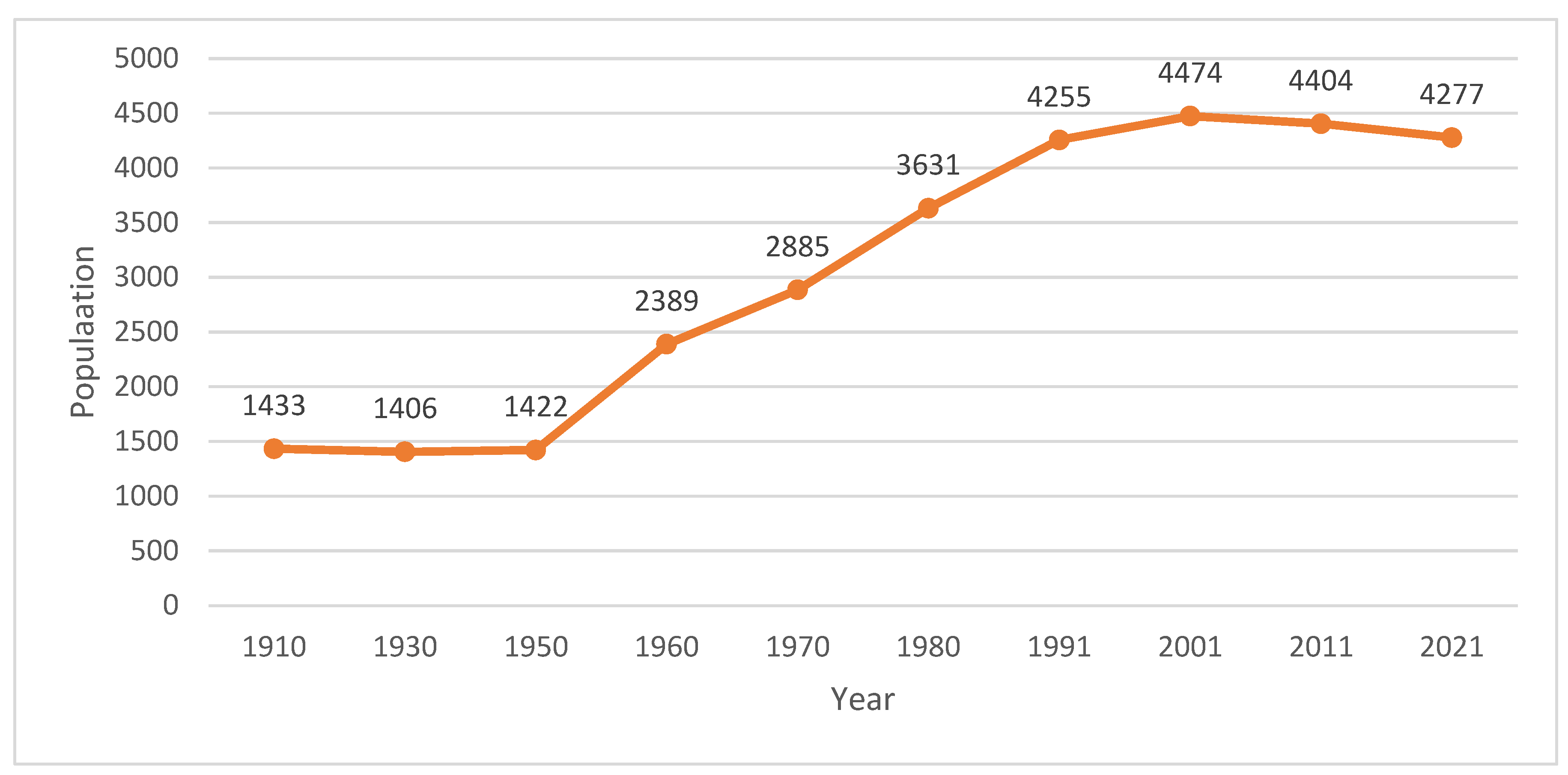
After the Czechoslovak coup d’état, when the Communist Party took over state power, our political direction and the national economy began to be subordinated to the higher interests of the USSR [10]. We transitioned from capitalism to a planned economy, in which the ongoing Five-Year Plans set the pace of economic development. It was obvious that the hitherto agrarian-oriented Slovakia would have to industrialise rapidly, on the basis of the “theory” of socialist industrialisation, according to which it was possible to build and develop industry only under the conditions of the dictatorship of the proletariat and the planned economy [11]. Industrialisation affected all regions of Slovakia, including Upper Zemplín in eastern Slovakia, which was considered one of the most backward regions in terms of industrial development [12]. In spite of smaller manufacturing enterprises and craft workshops, agriculture was predominant here [13,14,15]. The construction of three chemical plants in Humenné, Strážske and Vranov nad Topľou [12,16,17] was thus supposed to fulfil the priority of the Communist Party to equalise the living standards of the population in Czechoslovakia [10] and create a working middle class. In our research, we will focus on Strážske as a great example of the transformation of a former agricultural village into a modern socialist industrial town (Strážske acquired the status of a town in 1968) [13] and the transformation of an agrarian landscape into an industrial one. The construction of Chemko, n.p. Strážske began in 1952 and the trial operation started in 1955 [18]. However, many problems occurred during the construction and at the beginning of the operation. The industrialisation of the agrarian region required the migration of skilled labour from all over Czechoslovakia, which was in shortage in this region [12,16,17]. Along with the growing population (Figure 1), it was necessary to build housing estates, civic amenities and recreational facilities, which were an “associated” function of the chemical industry. It is important to note that the state was the main investor here. In first place was the coverage of basic needs such as housing, education and basic services of new employees, focusing on quantity over quality. After the establishment of Chemko as a chemical giant in the industry, the construction of other civic amenities, recreational facilities and individual housing began.
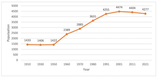
Figure 1.
Population growth in Strážske from 1910 to 2021. Data source: SO SR.
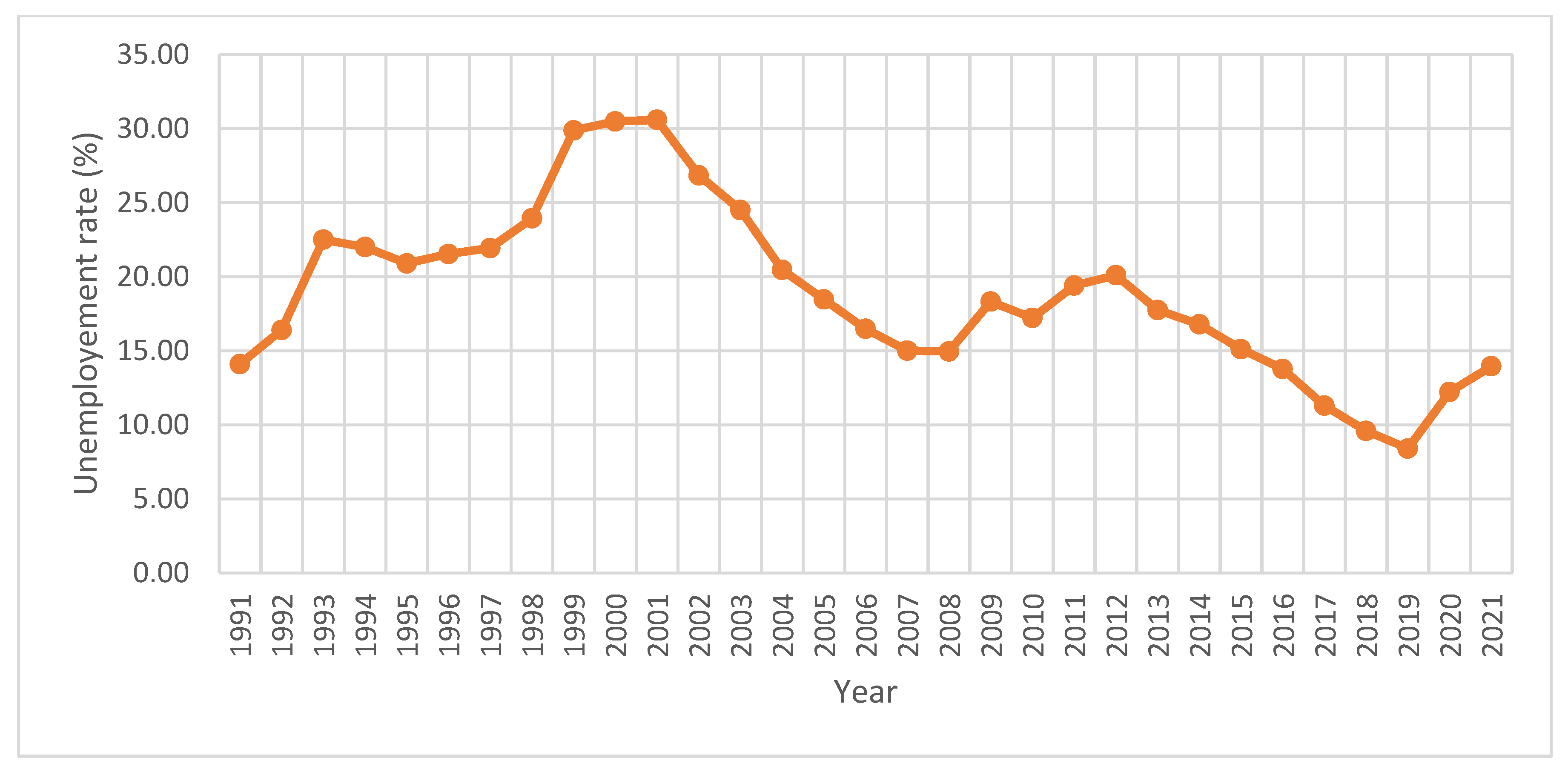
After the revolution in 1989, state-owned enterprises faced many challenges and sometimes liquidation because of their low competitiveness in the market economy [19]. The declining number of job opportunities rapidly affected rising unemployment (Figure 2), the outflow of skilled labour to more prosperous regions or abroad and the migration of young people for university studies who do not return home due to poor prospects [20,21]. The processes of demilitarisation, deagrarianisation and deindustrialisation started to appear later than in Western Europe, but their progress was much more intense [22]. The main outcome specific to post-socialist countries was the rapid emergence of agricultural brownfields [23], military brownfields [24] and industrial brownfields as the most pressing current problem [25]. The declining population and the emergence of brownfields are signs of “urban shrinkage” typical for post-industrial cities, resulting in the overall degradation of the physical urban environment and low competitiveness [26]. According to the United Nations, this trend will continue to deepen in Central Europe [27]; therefore, it is important to develop planning strategies and legislations for sustainability in shrinking cities at the national, regional and local levels [28,29,30].
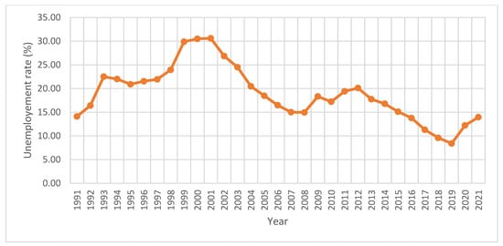
Figure 2.
Development of the registered unemployment rate from 1991 to 2021. Data source: SO SR, Centre for Labour, Social Affairs and Family.
The economic strength and vitality of shrinking cities depend on the quality of the environment, its identity, culture, accessibility and security, but due to the high pollution, low number, as well as low quality of job opportunities and always emerging brownfields, certain cities are considered less attractive to live in [31]. Therefore, the first step should be remediation of environmental burdens, which has a positive impact on further socio-economic development [32]. In Germany and other European countries, greenery is a cheap but slow way of remediation of contaminated brownfields [33]. Foreign experience with reviving post-socialist post-industrial cities has shown the effectiveness of greening vacant land and brownfields as a catalyst to developing healthier and more attractive cities and increase the quality of life of the inhabitants [26,28,34,35,36,37].
A well-known example is Leipzig in East Germany, which lost more than 20% of its population in the 1990s due to deindustrialisation. After the demolition of abandoned buildings, they started the greening process on vacant land [38], such as the creation of smaller parks, community gardens, playgrounds and areas of urban agriculture, which led to Leipzig’s high attractiveness and new population growth over the decades. Re-densification has begun to threaten popular green spaces on former brownfields due to pressure from investors [34]. During this period, the Ruhr industrial region (between Dortmund and Duisburg) was also transformed into the IBA Emscher Park, which created an interconnected system of parks regarding ecology [39]. The most effective approach is the prevention of the irreversible negative impact of the new development through compensatory or balancing measures (Chapter 3, Article 19 (1) of the Federal Nature Conservation Act, Germany) [40]. At first, a compensatory measure would mean the requirement that the investor during the construction (e.g., of a shopping centre) must take balancing measures based on ecological principles near or in the developed area (e.g., building a park). The second measure is an area “pool”, where the city has set aside a site for future compensatory measures, but nature protection has not yet been developed there. Finally, brownfield revitalisation can be an option, but several studies show that their revitalisation is concentrated in cities with higher development potential represented by the level of business activity, infrastructure development and proximity to the regional centre, whereas brownfield environmental pollution does not affect the revitalisation potential [22,41].
However, the challenge to greening of brownfield sites is legislative constraints, lack of funding and human resources and deficiencies in land-use-oriented spatial planning, which should rather focus on the sustainability of shrinking cities and planning towards resilience [42]. The ownership structure is, in practice, one of the biggest obstacles due to unsettled ownership relations, lack of funds for revitalisation in the case of city or state property or due to inaction of private owners. The main determinant is the aforementioned location of the brownfield depending on the development potential of the city, where it is located [22,41]. Slovakia, like all post-socialist European countries, belongs to the third category of countries with low population density and low level of competition (compared to the USA) [43]. The key to the industrial development and strengthening the competitiveness of the region is the transport connection to international transport corridors, especially the network of motorways and expressways [44], which are lacking in eastern Slovakia. The already existing industrial structure creates certain preconditions for its further development, but obsolete industrial areas are not attractive to investors, and in the case of new investment plans, new complexes are often built.
Post-industrial Slovak cities are affected by two periods of transformation based on time frames, namely 1948–1989 (period of growth) and 1989 to the present (period of decline). The transformation from 1948 to 1989 took place on two levels:
- Socialist industrialisation determined the spatial development of cities and the reconstruction of the original urban structure;
- Determined the transformation of agrarian landscape into industrial.
After 1989, the processes of deindustrialisation and urban shrinkage emerged, which influenced the development at two levels:
- The emergence of brownfields;
- Urban shrinkage;
- The landscape became post-industrial and revealed problems with environmental burdens.
The article is structured into the following sections: Section 2 describes the methodology, data and materials used in the study. Section 3 includes the research results divided into two parts: urban development and the proposed strategies for a sustainable and resilient shrinking town Strážske. The conclusion and discussion are presented in the last Section 4 and Section 5.
2. Materials and Methods
2.1. The Study Area
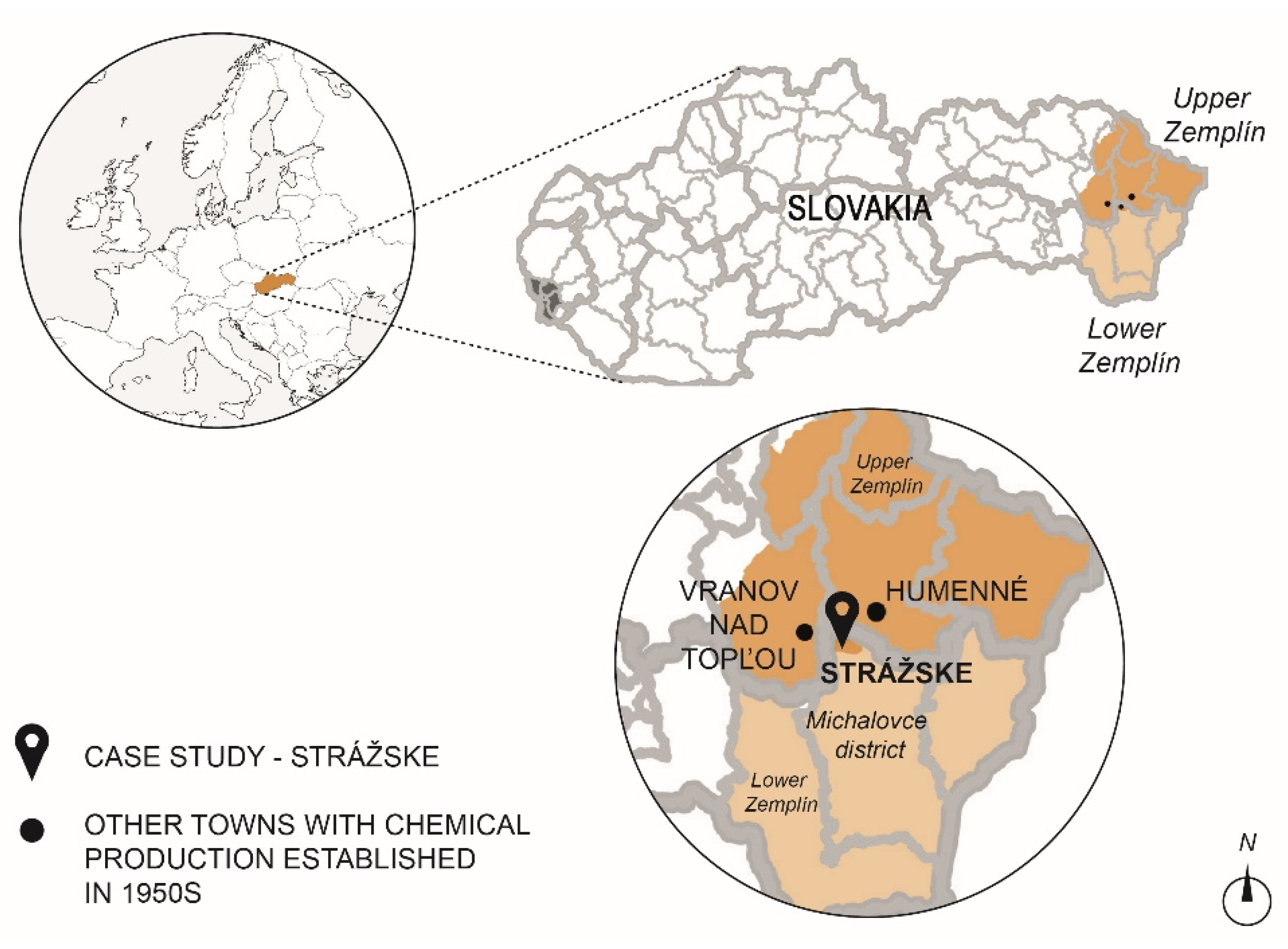
The subject of broader research, part of which is presented in this article, are three cities with chemical production established in the 1950s: Humenné, Strážske and Vranov nad Topľou. On the basis of their comparison, we conclude that Strážske is an ideal example of the impact of socialist industrialisation and deindustrialisation on the transformation of the urban structure and the landscape, also considering that Chemko Strážske is the largest chemical and faces the greatest challenges. Strážske is located in eastern Slovakia in the Michalovce District (Figure 3) and is one of the smallest towns in Slovakia with a population of 4277 (as of 2021) [45]. Historically, this town belongs to the region of Upper Zemplín and lies on the border with Lower Zemplín. The town is situated on the Easter Slovak flat between the Vihorlat Mountains and the Slanské Hills. During the second half of the 20th century, the spatially defined area of Chemko’s area was developed, but the urban structure of the town remained mostly homogenous, resembling the urban structure of the town centre typical for the socialist period. Urban greenery is represented by the historic town park near Manor houses, but no new areas of public green space have been created in the city since then. The nearby village Krivošťany (the town part at present) used to be one of the most northerly situated winery villages, and the urban structure has preserved the rural character.
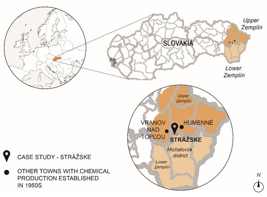
Figure 3.
The location of Strážske.
The main criteria for selecting Strážske as a case study were:
- Industrial areas make up the greater part of the built-up area of the town;
- High number of industrial brownfields;
- Population decline [20];
- Region with low competitiveness [44];
- The mass redundancies of 75 Chemka employees in March this year and the imminent bankruptcy [46];
- The environmental burden of the Poša sludge bed, where waste products were discharged from Chemko [47];
- The highest concentration of PCB pollution in Europe is in the Michalovce district [47].
Chemko currently offers part of its buildings and land for rent [48]. Therefore, it is probable that part of the site could be unused even if production is maintained. An impulse for the region is the new investor—the French company Smart wood, which should settle in a part of the former Chemkostav area and employ a hundred workers [49].
2.2. Research Methods and Data
The first stage of our research is to map the urban development of Strážske from the 1950s to the present and to evaluate the impact of socialist industrialisation and deindustrialisation after 1989 on the transformation of urban structure and landscape. The results will be used for the second stage of research to suggest perspective solutions and strategies addressing the issue of brownfields and environmental burdens. The results of our research will be presented in two parts:
- Urban development and assessment of the impacts of socialist industrialisation and deindustrialisation on the urban structure and landscape;
- The suggestion of strategies to create a sustainable and resilient shrinking town of Strážske. The suggestion of strategies to address the brownfield issue while creating the resilient shrinking towns of Strážske.
2.2.1. The First Stage of Research—Method
Factors influencing the urban structure development from the 1950s to the present were socialist industrialisation from 1948 (after the Czechoslovak coup d’état) to 1989 (Velvet Revolution) and later deindustrialisation after 1989, which continues to this day (Figure 4). Therefore, we examine the urban structure and landscape in terms of breakthrough historical events, based on Hinse’s approach [50]. The morphological research was carried out based on historical maps, whose selection was based on their availability and scale, as well as key periods for drawing a comprehensive picture of urban development (Table 1). These historical maps are available through national and other map databases, freely accessible to everybody. The time span captured on historical maps includes the year 1950, years 1952–1957, year 1989 and the present (year 2022). The scales of these maps are consistently 1:25,000. We have plotted the mapped results as schwarzplan with a street network, watercourses, landscape elements and public green spaces. All of the mentioned traits are available in the studied maps. Our starting point was schwarzplan, picturing the current urban structure. The currently non-existent buildings have been redrawn, and we have drawn all the buildings except the temporary farm buildings. The landscape features, such as arable area, vineyards and others, were mapped according to the maps and the factual state of the mapped period. The schemes picture the landscape and urban structure with highlighted industrial zones (industry and animal production).

Figure 4.
Timeline picturing the breakthrough historical events that determined the urban and landscape development in Strážske.

Table 1.
The cartographic resources used for mapping the urban structure development.
The mapping of environmental burdens was based on the data from the Enviroportal (Information Portal of MoE SR), which is a national database of environmental burdens supported by MoE SR, mapping their location, extent of pollution, cause of pollution and also suggests the actions taken on mitigating them. All the information obtained is available in the List of Environmental Burdens [51] containing four categories of environmental burdens:
- Potentially contaminated site (A)
- Contaminated site (B)
- Remediated, reclaimed site (C)
- Contaminated site excluded from registers (D).
For Strážske, the first three categories (A–C) are relevant, in the mapped cadastral areas of Strážske and surrounding villages Poša and Voľa, where the sludge pond and waste channel of Chemko are located.
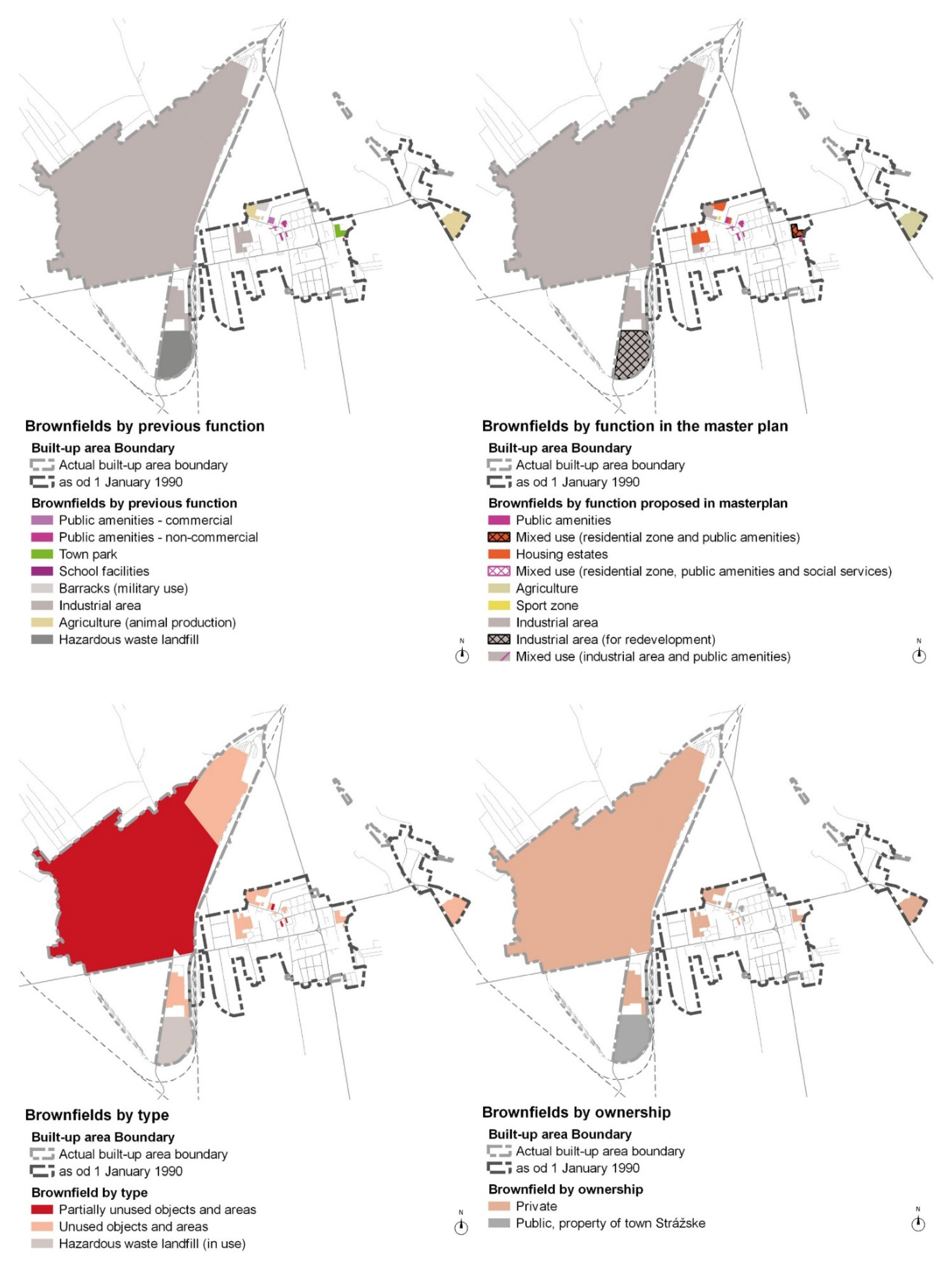
We used a combination of “desktop analysis” and field survey to map brownfields [52]. The initial mapping starts with the “desktop analysis” where we determined the current state of the area based on orthophoto maps. The source of the ownership data is the national database Real Estate Cadastre [53], which helped us to determine the private or public ownership and the owner himself. For companies, we verify whether they are still in operation, in bankruptcy or have cancelled their activities using the national database Business Register (Ministry of Justice of the Slovak Republic) [54]. All three databases are national and publicly available and use the most current information, which is why they are often used in spatial planning. These data, including mapping the current state, are the base for a field survey, where we determine the actual state of the area. The diagrams show brownfields according to the previous use, the type of brownfield, the proposed function according to masterplan of Strážske and the ownership structure.
2.2.2. The Second Stage of Research—Method
We used the results of morphological research as the base for finding perspective solutions to the problem of brownfields and devastated land by chemical production. Our suggested solutions represent four scenarios based on several foreign experiences mentioned in the introduction [34,38,39,40], which focused on the revitalisation of brownfields and landscape in shrinking cities and strategies for shrinking cities. The research findings can be used for the creation of a non-binding spatial planning document for further spatial planning documents and masterplan of Strážske. It can also serve as a document or a database for local government when deciding on an investment project.
Scenario “A” will test the appropriateness of demolishing disused and dilapidated buildings, which is a costly solution, but in some cases, the only one. This applies to significantly dilapidated buildings whose structural condition is inadequate or the buildings that have been degraded by production and are therefore unsuitable for further use. In the case of larger areas, this may involve the demolition of some buildings or groups of buildings. Land after demolition may be used to create a green space, which is scenario “B”. However, the creation of green spaces may involve vacant land or greatly abandoned existing green areas, thus supporting the creation of a “green city” in the long term. Another alternative is the establishment of a temporary function (scenario “C”), which, depending on the demand for construction, can again become building land or permanent green space. The last scenario “D” is the transformation of the brownfield, where its profitability and positive benefits for the town and its inhabitants are crucial (Table 2). Scenarios are follow-ups, so for some brownfields, it is appropriate to combine them in the proposed order.

Table 2.
The criteria for selecting the scenarios used in our case study.
The degree of sustainability of the study and the proposed scenarios depends on the final implemented measures. There are many frameworks for sustainability evaluation, but the most appropriate is the Slovakia 2030 Implementation Indicators measurement methodology [55], developed under the Slovak Statistical Office, taking into account the needs of all regions and regional development. Like other frameworks, this study also uses common environmental, economic, social and institutional indicators. However, we will not measure the degree of sustainability, given that this is not the aim of this paper.
3. Results
3.1. The First Stage of Results
3.1.1. Strážske and Its Urban Development
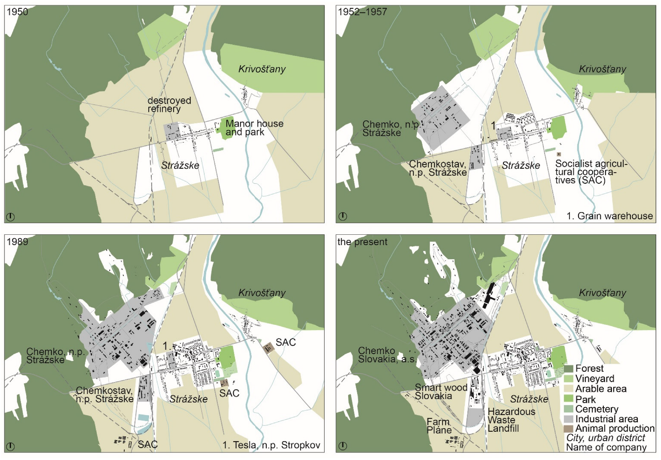
In 1950, Strážske was a typical agricultural village with an urban structure of single-family dwellings along the main road, which stays the main compositional axis to this day. At the eastern end of the main road lies a historical park with the original Baroque and new Art Nouveau mansions. Before the nationalisation, it served as the Széchenyi estate, which employed several inhabitants of Strážske. At the western end of the village stood the destroyed refinery serving as a grain warehouse for Strážske and nearby villages, and the railway with the station. Despite the small size of the village, it had two churches, which remain to this day. East of Strážske is the Krivošťany village with a small square and the church in its centre, around which formed an urban structure of single-family dwellings surrounded by vineyards. Other vineyards were located north of Strážske and between the railway and the forest massif; there was arable land, which also surrounded the village itself (Figure 5).
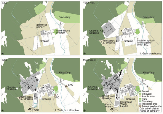
Figure 5.
Schemes of urban development of Strážske from 1950 to the present with marked landscape elements and industrial zones as well as animal production zones.
However, the 1950s were crucial for Strážske in terms of urban development, as The construction of Chemko progressed rapidly and Chemkostav grew on the other side of the main road. West of the railway, a functionally defined industrial area was created on formerly arable land, which was the only source of livelihood for many inhabitants before the construction of Chemko. North of the single-family dwellings, the Okružná housing estate grew with a kindergarten and a creche, meant specifically for the new employees of Chemko. The nearby A. Dubček’s Square changed its appearance from a street to a civic amenities centre with a new post office and small department store on its eastern side, which had not yet been developed. Adjacent to the original urban structure, the area of “associated” functions necessary for the operation of the chemical plant was created (housing estate, civic amenities, etc.). Family houses typical for the changing village were also built. In Krivošťany, the vineyards began to retreat to the forest (Figure 5). In this period of urban transformation, we see a shift from an agricultural to a heavy-industry-oriented economy, which manifested in the transformation of the agricultural land into the chemical plant site.
During the following decades until 1989, Chemko’s position as a chemical giant in the national economy was confirmed by the changing urban structure and image of the former agricultural village. Reconstruction of the town centre began in the 1960s with the construction of the second department store, Hostel Chemik and Cinema Chemik. The status of a town obtained in 1968 confirmed the changing image of Strážske. New housing estates were built near the main crossroad in the east, and a zone of single-family houses and terraced housing was created in the south, as well as in the north and west. The predominance of individual housing developments indicated that Strážske, despite becoming a town had a strong rural tradition. The sports and recreation zone, with a swimming pool, bowling alley and ice rink, was located in the northern part of the city near the Tesla Stropkov complex. The recreational facilities were built by Chemko (and the state) as the main investor. The growing industrial zone of Chemko and Chemkostav was and still is disproportionately larger compared to the structure of the town itself, which is dominated by single-family dwellings over housing estates. Socialist agricultural cooperatives with local animal production had three areas, of which two were in Strážske and one in Krivošťany. They replaced the role of private farming. The described development confirms that socialist industrialisation and was the determinant of the urban development of Strážske, which grew only for the chemical industry. Therefore, the facilities built in this period can be described as “associated” functions, designed mainly to support the development of the industry. The missing areas of arable land occupied by the Chemko were replaced by new ones, closer to the town and the Laborec river. The vineyards north of Strážske retreated to the forest (Figure 5).
Since 1989, the most extensive development has been in the industrial zone, but in the structure of the city, development has been limited to some single-family dwellings and a few town buildings. We can see that the role of the main investors—Chemko and the state—transformed into private development roles. Nevertheless, deindustrialisation affected the industrial companies and finally led to the emergence of brownfields. The changes in the landscape since 1989 do not seem significant at first glance, but chemical production has caused environmental burdens and rapid urban development has permanently changed the landscape image.
3.1.2. Environmental Burdens in Strážske
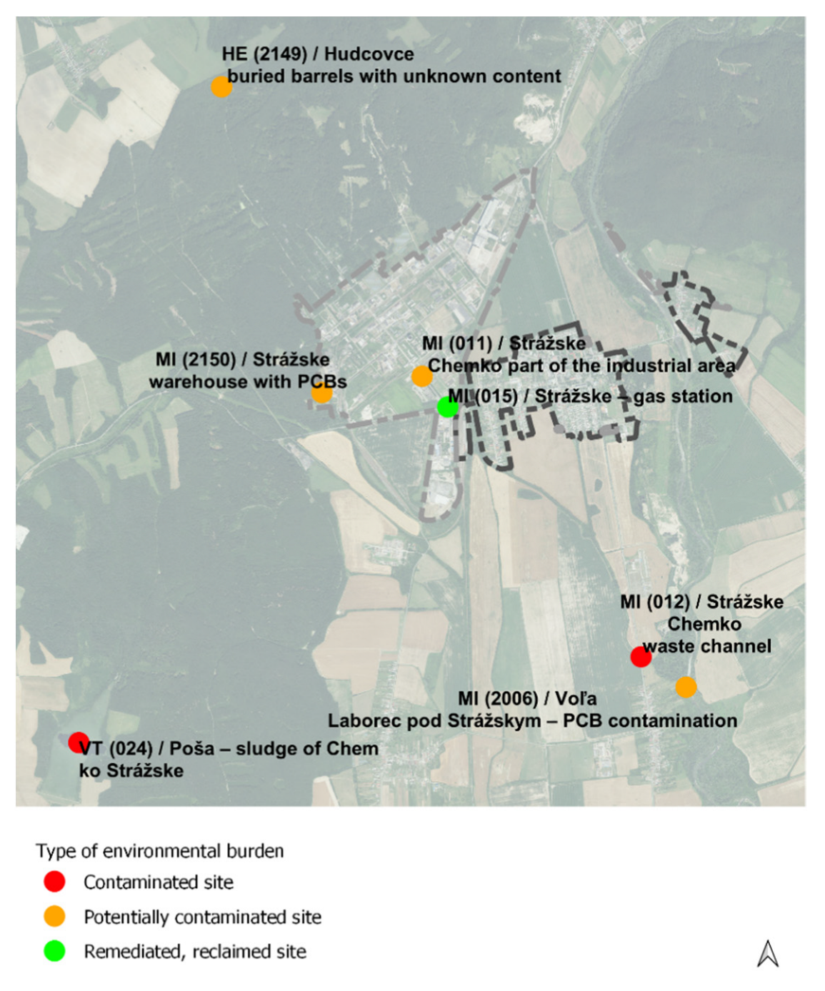
The main goal of this part of the results was to map the environmental burdens to evaluate the impact of chemical production on the state of the environment and the extent of it. We know from the mapping of environmental burdens (Figure 6, Table 3) that there are no contaminated sites (B) in the Chemko area, but there are two potentially contaminated sites (A). The first is Chemko—part of the industrial area and the second is a warehouse with PCBs, the removal of which began in November last year [56] after the declaration of an emergency in January 2020 [57]. Therefore, it is unclear why the environmental burden is still recorded only as a potentially contaminated site. South of Strážske in the Voľa village, there are two environmental burdens. The first one is Chemko—a waste channel marked as a contaminated site (B) and the second is Voľa (Laborec pod Strážskym)—PCB contamination marked as a potentially contaminated site (A). This contamination was also caused by chemical production when waste materials after production were removed by waste channels to the Zemplínska Šírava (dam used for recreation). Northwest, on the border of the cadastral area of Strážske and Hudcovce, is a potentially contaminated site (A) called Hudcovce—buried barrels with unknown content. The biggest ecological disaster in this region is the Poša sludge bed located southwest of Strážske. In the 1980s, waste materials from chemical production (including PCBs) were released into the Poša sludge bed. The concentration of PCBs exceeded critical values here, but the exact concentration remains unknown.
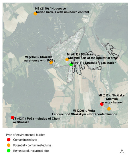
Figure 6.
Diagram of locations of environmental burdens according to Enviroportal. Data source: Enviroportal, List of Environmental Burdens.

Table 3.
Environmental burdens in Strážske and its surrounding villages related to Chemko Strážske. Data source: Enviroportal, List of Environmental Burdens.
3.1.3. Brownfields in Strážske
In Strážske the dominating areas are industrial brownfields, areas after socialist agricultural cooperatives, a military brownfield (Figure 7) and the mentioned “associated” civic amenities (e.g., Hostel Chemik, Cinema Chemik, etc.), built by Chemko for their employees. The extent of unused land and buildings in the Chemko area is not known, because it is impossible to map the current situation. However, we do know that there are buildings and sites for rent [48]. Due to the impending bankruptcy, it is possible that the whole area will become a brownfield. For that reason, it is crucial to find solutions for further development before Chemko turns into a brownfield. North of Chemko is the bankrupt factory Steel Mills Slovakia, a.s., which was bought by the steel holding Max Eicher in 2018 but has not yet resumed production [58]. After the transformation, Chemkostav went bankrupt and over the years, several companies were based in this area. At present, a great part of the area is unused with severely dilapidated and some unfinished buildings, but in the eastern part of this area, Smart wood Slovakia has settled as the new investor. To the south of Chemkostav lies a hazardous waste landfill, which should have been recultivated according to Strážske’s master plan, but this is still in operation. In the former barracks zone, the western part belonged to the bankrupt ATV cooperative of Strážske and the eastern part is unused except for the central building transformed into social housing. The master plan proposes a transformation into housing. The former refinery (later other production facilities, such as Tesla Stropkov) is largely unused and fully privately owned. The master plan proposes a combination of light industry and housing, which can be potentially risky due to the long-term industrial use of the area. In Krivošťany, we identified an unused socialist agricultural cooperative as the only brownfield.
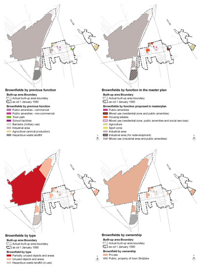
Figure 7.
Diagram of brownfields mapped and sorted by previous function, function in the masterplan, type and by ownership.
Another category consists of the unused or partially used buildings, especially in the city centre, which were built during the socialist period as “associated” functions. They offered facilities for the town inhabitants and Chemko employees at the same time. They are both morally and physically obsolete, and the current needs of the city require their transformation. The most prominent representatives of such architecture are Cinema Chemik and the commercial part of the former Chemik Hostel. The cinema has been partially renovated, but the city does not have the funds to operate it. The commercial part of Hostel Chemik is for sale long-term, and three residential blocks transformed into social housing require additional investment. One of the consequences of low purchasing power and the impact of COVID-19 are the bankrupt retail outlets and restaurants on A. Dubček’s Square. Near Okružná housing estate are two buildings that originally served as school and preschool facilities. One of them is unused in private ownership and the other is partially unused property of the town. In the former barracks is one unused object in a property of the town and the master plan recognises it as having a sports function. There are two manor houses in Strážske: the original late Baroque and the new Art Nouveau, but both have been abandoned for a long time. The late Baroque manor house and its surroundings are currently divided into building lots for single-family dwellings and roads. The transformation of the manor house, with its remediation, is probably irreversible. The Art Nouveau manor house is also in private ownership and continues to decay.
Further redevelopment of brownfields in Strážske is impacted by key factors and related challenges (Table 4). Continuous mapping and updating of the brownfield’s list are important due to the constantly changing situation. However, the town itself lacks capacity, but there could be helpful systematic support from the state in terms of methodology, etc.

Table 4.
The key factors (result findings) affecting the brownfield redevelopment in Strážske.
3.2. The Second Stage of Results
Strategies for a Sustainable and Resilient Shrinking Town Strážske
The main goal of the second part of the research was to propose prospective scenarios for the development of brownfield sites in Strážske. The most important findings are:
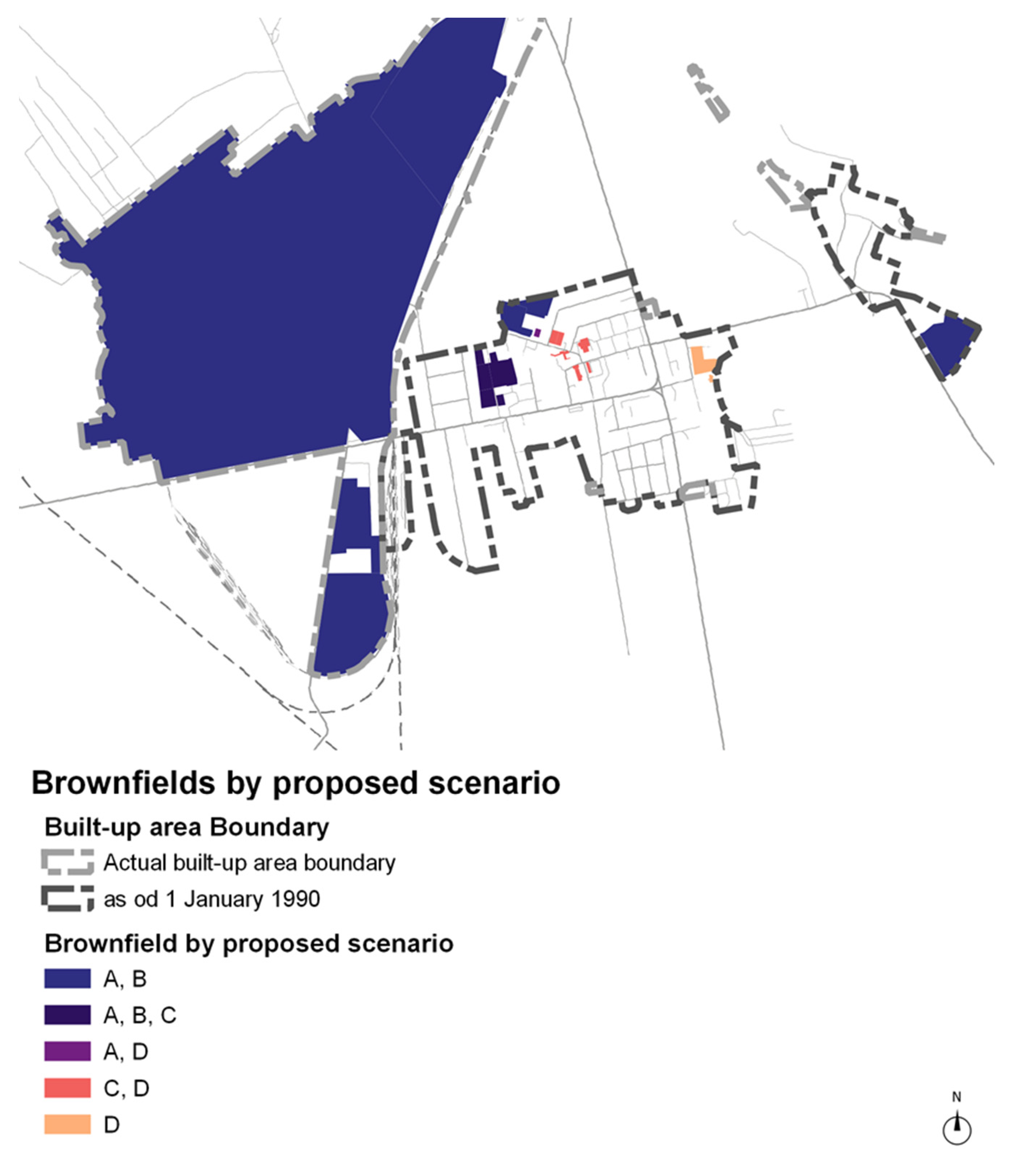
- The layout pattern (Figure 8) confirms the location dependence with the town area of proposed solutions.
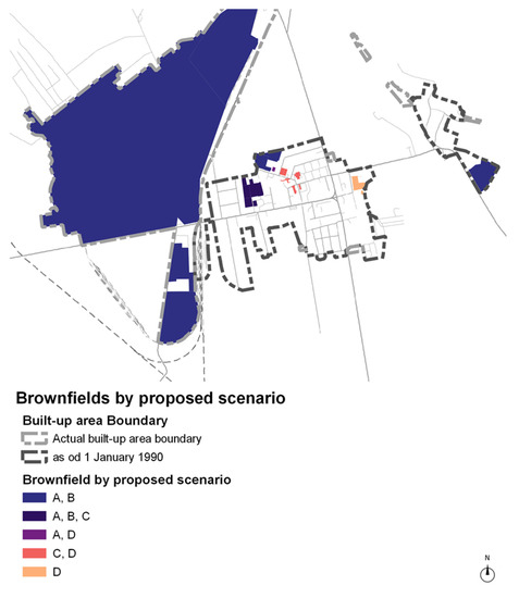 Figure 8. Diagram of brownfields sorted by proposed scenario.
 - Temporary functions and transformation (C, D) of function are concentrated in the town centre, implying the importance of re-densification and accessibility of such functions.
- Demolition and green areas (A, B) are concentrated at the outer edge of the built-up area implying that the shrinking of the built-up area closer to the period before rapid development is possible, as well as the importance of incorporating the green spaces in town.
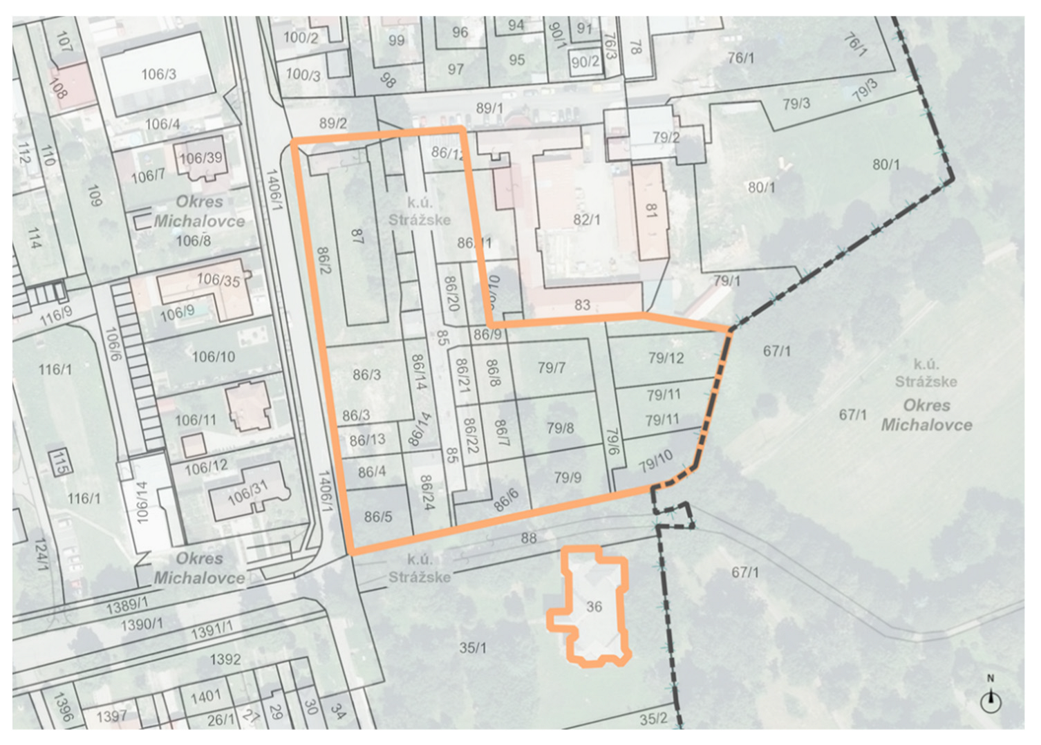
Based on the results of the first stage of the research—the list of mapped brownfield sites—we are exploring strategies for the development of a sustainable and resilient shrinking city of Strážske. According to the established criteria, we assigned the brownfields prospective scenarios for their perspective future development. Civic amenities on A. Dubček’s Square and its surroundings are suitable for temporary functions or transformation (C and D). Of the seven buildings, four are owned by the city, which allows to easily manage and support the local community via suitable functions. The central location within the town implies that such transformations could have a significant positive impact on the image and attractiveness of the town. Former industrial and agricultural areas on the border of the built-up area are suitable for demolition (A) and greening (B), which will help alleviate the environmental burden and restore the landscape. The transformation of buildings for non-production purposes is also unsuitable for contamination of the area. This area could potentially bring the landscape features closer to the city and have a greater impact on the overall health of the environment as well. The original production zone (refinery) has been overgrown by urban structures over the years (from the borderline position to the inner city) and is presently surrounded mainly by the development of family houses. Due to the long history of production and possible contamination, the area is unsuitable for transformation into a residential zone, as the master plan proposes. Given the scale of the area, we have identified dilapidated buildings for redevelopment (A), subsequent greening of the brownfield (B), creation of a temporary function (C) or a combination of these (B and C). Finally, there are the manor houses, where the Art Nouveau manor house is privately owned and has been dilapidated for a long time, it is therefore questionable whether the building can be revitalised while preserving cultural values. The original late Baroque manor house probably cannot be saved as there is planned development of single-family dwellings (see above) (Figure 9). Ideally, we would recommend them for transformation (D) to create functional uses supporting the town community.
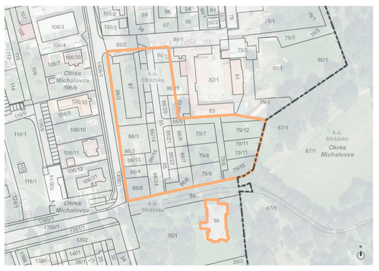
Figure 9.
Parcellation of late Baroque manor house (pink colour) and its surroundings into building lots and roads for housing development.
The proposed scenarios could be used as a non-binding spatial planning document for further proposal of a master plan and local strategies. At the same time, the city government can use the results to find suitable areas for new investment plans, transformation or the creation of green spaces.
4. Discussion
The topic of remediation of the landscape after chemical production in Chemko Strážske has been postponed for decades and has not received sufficient attention, despite the knowledge of heavy PCBs contamination [47,57]. In the context of small towns in Central Europe, not enough attention is paid to the possibilities of brownfield revitalisation towards sustainable and resilient towns and the support of local communities. The presented paper introduces new content for further research regarding other small shrinking post-industrial towns in Slovakia (and in Central Europe in general) after mining (Handlová, Gelnica, Novoveská Huta and others), metallurgy (Sereď, Žiar nad Hronom, Krompachy) and other heavy industries (Snina and others), which currently face similar challenges as Strážske.
Currently, we do not have a comprehensive database of brownfields in Slovakia or a complex methodology for their mapping and the assessment of their risk of environmental burdens, unlike the neighbouring Czech Republic [59]. The available methodology of the Ministry of Transport and Construction of the Slovak Republic (MTC SR) focused on obstacle analysis and brownfield assessment [60] is not sufficiently put into practice. The database of brownfields processed by the SARIO agency [61] focuses mostly on regional centres, but due to the predominance of small and medium-sized towns in Slovakia, the key should be to map brownfields in these towns. Also, the evidence of brownfields is not complete. The survey detection of the status and barriers for the revitalisation of unused and neglected areas in built-up areas of cities in Slovakia realised by the MTC SR in 2019 focused on local governments and collected the answers to determine the main obstacles to brownfield revitalisation. Every town in Slovakia took part in this survey and the findings were that towns with over 50,000 citizens have revitalised more brownfield areas. The problem lies with the fragmented ownership structure, the inability to force owners into action and the absence of sufficient legislative (higher taxes for unused land, expropriation of the property, absence of brownfield term in legislative on spatial planning, etc.) and systematic evidence of brownfields. Towns under 4999 citizens lack mostly financial support and the biggest barrier is ownership structure. All the respondents agreed that for the successful revitalisation of brownfields, systematic help and support from the state and financial support are crucial [62]. Towns in the category of over 50,000 citizens have also agreed on systematic support from the state in terms of providing the guidelines for revitalisation and professional support.
Brownfield renewal in Slovakia is almost exclusively focused on its revitalisation in growing cities such as Bratislava and Košice due to high profitability, which proves that the motivation for brownfield revitalisation is mainly financial gain for the investor. The main problem is the functional use of transformed brownfields, which mainly represent residential areas and commercial centres and the risk of loss of cultural values [63]. In order to reduce costs, most of the local governments sold their properties, which means that currently they do not have the opportunity to influence the transformational processes [64], and under pressure from investors, the former downtown is being transformed into a new city center [65]. The situation is different in small and medium-sized towns, where the return on investment is low and the transformation is not attractive for investors. Local governments (civic associations, volunteers, etc.) have a unique opportunity to use abandoned buildings to support local communities, as proposed in the manual by Milota Sidorová [64]. Supporting these functions does not necessarily have to be financially demanding, and this is where the potential for the multifunctional and temporary functions is verified according to case studies in the mentioned manual [64]. However, this guide focuses only on buildings in the property of the towns but broadening the focus on lots or even whole areas could strengthen the potential of revitalisation and positive impact on towns as a whole. A barrier to brownfield revitalisation for towns under 4999 citizens is the lack of finance and fragmented ownership structure [62]. The absence of systematic support from the state and financial support is a limiting factor to our proposed scenarios, as well as every brownfield redevelopment project. The aforementioned research confirmed that the revitalisation of unused and abandoned land has the potential to be the catalyst of regional development, as well as the low interest of developers in such plots. These contradictory statements reaffirm the need for a systematic strategy at the national level and the potential for brownfield redevelopment. Shrinking cities with a high concentration of socio-economic challenges require strategies at the town scale because the brownfield issue is highly connected to city-wide problems. The revitalisation of large areas (up to entire cities) after a monofunctional industry has a few positive examples in Slovakia. Due to our rich mining history, we have many mining brownfields, but especially those with high cultural and historical values have undergone a successful transformation, for example, Banská Štiavnica and its surroundings. Many authors deal with the issue of their transformation into tourism centres [66,67,68,69], but with less emphasis on landscape regeneration and the green infrastructure in cities. Likewise, the promotion of sustainable tourism in the Danube region (also shrinking), does not work with a surplus of brownfields and their transformation into green spaces [70,71]. There is a lack of studies dealing with brownfield regeneration as a possible element of green infrastructure, such as the study presented here, which indicates great potential for deepening this issue in Slovakia [20,72,73]. However, the lack of direct experience may be a disadvantage and future projects can face limitations and challenges. All of the above-mentioned studies have a general approach to addressing the brownfield issue, focusing on general criteria and parameters for mapping and evaluation without considering the broader context, which leads to general results. Therefore, a contribution of our study is examining the brownfield issue in a broader historical and spatial context, focusing on specific criteria for the mapping and evaluation of brownfields and suggesting solutions specific to the case study with the potential for a positive impact on the whole town. Likewise, many researchers have an interest in areas with high cultural and historical values (like Banská Štiavnica, etc.), but we do not see many successful examples of the transformation of heavy industrial areas with origins in the second half of the 20th century. The urban structure of Strážske is a result of socialist industrialisation, the decisions of the Communist Party and the subordination of the higher goals of the USSR. The contrast of the centrally planned economy, when the construction of industrial enterprises took place based on political decisions and the current market economy environment, brings challenges that are not given sufficient attention. There is a potential for cooperation between towns in the region in order to transform into a centre of tourism and recreation in nature (there are Zemplínska Šírava and Domaša reservoirs nearby, as well as hiking opportunities). The case study of Strážske presents the current problems of many Slovak towns belonging to the category of post-industrial medium and small towns. This topic has the potential to be a nationally relevant point with benefits for spatial planning practice.
In our research, we focus on both the transformation of buildings and the overall transformation of the town and landscape. The town is a living organism that needs a holistic approach to solve issues as important as urban shrinkage and pollution. Therefore, a combination of these approaches can result in a healthy green town and an attractive place to live. The use of the proposed scenarios taking into count the set criteria is possible for other case studies due to their universality for small and middle-sized post-industrial towns, meaning most of the Slovakian towns. The findings of our research could be used as a non-binding spatial planning document, but they can also be further deepened, which would provide Strážske’s local government with additional necessary information during revitalisations. Likewise, the generalisation of the findings can be the basis for the brownfield development strategies of all post-industrial shrinking cities in Slovakia.
5. Conclusions
The results of the research present four prospective scenarios to address the issue of brownfields in post-industrial, post-socialist cities in Slovakia in the broader context of historical events that affected the urban and landscape development in Upper Zemplín—town of Strážske. Shrinking towns are less economically attractive for brownfield redevelopment, so there is a necessity to find new approaches in terms of sustainable development relating to urban shrinkage, high pollution and other challenges. This creates unprecedented potential for reviving shrinking towns through brownfield areas, which can become the catalyst for change. However, there is a lack of sufficient and systematic legislative and financial support and guidelines for revitalisation and professional support from the state, which makes brownfield transformation even harder for these towns. Changing the methodology of evidence, revitalisation, financing and other necessary steps should be addressed at the national level. In general, it will be hard for many local governments, shrinking towns in particular, to transform brownfields without state support. The change is also necessary for spatial planning legislatives and methodologies, because evidence of brownfields and their incorporation into master plans is essential for urban development.
Author Contributions
Conceptualisation, R.H.; methodology, R.H.; software, R.H.; validation, R.H. and A.S.; formal analysis, R.H.; investigation, R.H.; resources, R.H. and A.S.; data curation, R.H.; writing—original draft preparation, R.H.; writing—review and editing, R.H.; visualisation, R.H.; supervision, A.S. All authors have read and agreed to the published version of the manuscript.
Funding
This research received no external funding.
Institutional Review Board Statement
Not applicable.
Informed Consent Statement
Not applicable.
Data Availability Statement
Publicly available datasets were analysed in this study. These data can be found here: Enviroportal (Information Portal of MoE SR) and List of Environmental Burdens [Enviroportal. List of Environmental Burdens—Information System of Contaminated Sites. Available online: https://envirozataze.enviroportal.sk/ (accessed on 8 May 2022), Real Estate Cadastre [Real Estate Cadastre. Available online: https://zbgis.skgeodesy.sk/mkzbgis/sk/kataster?bm=zbgis&z=13&c=21.830270,48.875354&sc=n&pos=48.800000,19.530000,8 (accessed on 12 May 2022)], Business Register (Ministry of Justice of the Slovak Republic [Business Register of MoJ SR. Available online: https://www.orsr.sk/default.asp?lan=en (accessed on 12 May 2022)].
Conflicts of Interest
The authors declare no conflict of interest.
References
- Tsenkova, S.; Nedović-Budić, Z. (Eds.) The Urban Mosaic of Post-Socialist Europe: Space, Institutions and Policy; Physica: Heidelberg, Germany, 2006; pp. 3–20. ISBN 978-3-7908-1726-3. [Google Scholar]
- Sýkora, L. Post-Socialist Cities. In International Encyclopedia of Human Geography; Kitchin, R., Thrift, N., Eds.; Elsevier: Oxford, UK, 2009; Volume 8, pp. 387–395. ISBN 978-0-08-044910-4. [Google Scholar]
- Haase, A.; Bernt, M.; Grossmann, K.; Mykhnenko, V.; Rink, D. Varieties of Shrinkage in European Cities. Eur. Urban Reg. Stud. 2013, 12, 1–17. [Google Scholar] [CrossRef]
- Stanilov, K. (Ed.) The Post-Socialist City; Springer: Dordrecht, The Netherlands, 2007; pp. 3–15. ISBN 978-1-4020-6052-6. [Google Scholar]
- Hamilton, F.E.I.; Dimitrowska-Andrews, K.; Pichler-Milanovic, N. (Eds.) Transformation of Cities in Central and Eastern Europe: Towards Globalisation; United Nations University Press: Tokyo, Japan, 2005; pp. 3–21. ISBN 9280811053. [Google Scholar]
- Sýkora, L.; Bouzarovski, S. Multiple Transformations: Conceptualising the Post-communist Urban transition. Urban Stud. 2012, 49, 43–60. [Google Scholar] [CrossRef] [Green Version]
- Bontje, M. Facing the Challenge of Shrinking Cities in East Germany: The Case of Leipzig. GeoJournal 2004, 61, 13–21. [Google Scholar] [CrossRef]
- Stryjakiewicz, T. The Process of Urban Shrinkage and its Consequences. Rom. J. Reg. Sci. 2013, 7, 29–40. [Google Scholar]
- Hirt, S. Whatever happened to the (post)socialist city? Cities 2013, 32, 29–38. [Google Scholar] [CrossRef]
- Londák, M. Otázky Industrializácie Slovenska (1945–1960); Veda: Bratislava, Slovakia, 1999; pp. 7–52. ISBN 978-80-224-0570-1. [Google Scholar]
- Petrosjan, K.A. Sovětký Způsob Industrialisace; Svoboda: Prague, Czech Republic, 1952. [Google Scholar]
- Markovič, J. Chemko Národný Podnik Strážske: Nositeľ Vyznamenania Za Zásluhy o Výstavbu: 1952–1977; Východoslovenské vydavateľstvo: Košice, Slovakia, 1977; pp. 13–15. [Google Scholar]
- Adam, J. Dejiny Strážskeho; Excel Enterprise: Michalovce, Slovakia, 2008; ISBN 978-80-89258-25-3. [Google Scholar]
- Fedič, V.; Adam, J.; Belej, M.; Bodnárová, M.; Hraboský, P.; Kónya, P.; Meričko, J.; Michnovič, I.; Rosič, M.; Strakošová, I.; et al. Dejiny Humenného; Vasil FEDIČ—REDOS: Humenné, Slovakia, 2002; pp. 45–301. ISBN 80-968790-4-9. [Google Scholar]
- Michnovič, I. Vranov nad Topľou v 20. storočí. Časť druhá: 1948–2000; PRINTON: Vranov nad Topľou, Slovakia, 2005; pp. 49–77; 198. ISBN 80-969263-2-2. [Google Scholar]
- Komanický, V.; Olexa, J. Chemlon Národný Podnik Humenné; Východoslovenské vydavateľstvo: Košice, Slovakia, 1978; pp. 15–16. [Google Scholar]
- Jevín, M. BUKÓZA Národný Podnik VRANOV nad TOPĽOU; Východoslovenské vydavateľstvo: Košice, Slovakia, 1976; pp. 53–81. [Google Scholar]
- Drotár, M.; Grmolcová, G. Chemko Národný Podnik Strážske 1952–1982. Nositeľ Radu Práce; Východoslovenské vydavateľstvo: Košice, Slovakia, 1982; p. 13. [Google Scholar]
- Baláž, V. Od montažnej dielne k inteligentnej ekonomike. In Odkiaľ a Kam. 20 Rokov Samostatnosti; Meseznikov, G., Bútoróvá, Z., Kollár, M., Eds.; Kalligram/IVO: Bratislava, Slovakia, 2013; pp. 566–581. [Google Scholar]
- Hajduková, R.; Sopirová, A. Brownfields and Green Infrastructure in the Region of “Triangle of Death”. In Proceedings of the DOCONF/2021 Facing Post-Socialist Urban Heritage, Budapest, Hungary, 8–9 October 2021; pp. 182–193. [Google Scholar]
- Novotný, L.; Csachová, S.; Kulla, M.; Nestorová-Dická, J.; Pregi, L. Development trajectories of small towns in east Slovakia. Eur. Countrys. 2016, 4, 373–394. [Google Scholar] [CrossRef] [Green Version]
- Frantál, B.; Kunc, J.; Nováková, E.; Klusáček, P.; Martinát, S.; Osman, R. Location matters! Exploring brownfields regeneration in a spatial context (case study of the South Moravian Region, Czech Republic). Morav. Geogr. Rep. 2013, 21, 5–19. [Google Scholar] [CrossRef]
- Skála, J.; Vácha, R.; Čechmánková, J.; Horváthová, V. Various aspects of the genesis and perspectives on agricultural brownfields in the Czech Republic. Morav. Geogr. Rep. 2013, 21, 46–55. [Google Scholar] [CrossRef] [Green Version]
- Hercik, J.; Šimáček, P.; Szczyrba, Z.; Smolová, I. Military brownfields in the Czech Republic and the potential for their revitalisation, focused on their residential function. Quaest. Geogr. 2014, 33, 127–138. [Google Scholar] [CrossRef] [Green Version]
- Kunc, J.; Navrátil, J.; Tonev, P.; Frantál, B.; Klusáček, P.; Martinát, S.; Havlíček, M.; Černík, J. Perception of urban renewal: Reflexions and coherences of socio-spatial patterns (Brno, Czech Republic). Geogr. Tech. 2014, 9, 66–77. [Google Scholar]
- Rieniets, T. Shrinking cities: Causes and effects of urban population losses in the twentieth century. Nat. Cult. 2009, 4, 231–254. [Google Scholar] [CrossRef]
- Klingholz, R. Europe’s Real Demographic Challenge. Policy Rev. 2009, 157, 61–70. [Google Scholar]
- Hollander, J.B.; Pallagst, M.K.; Schwarz, T.; Popper, F.J. Planning shrinking cities. Prog. Plan. 2009, 72, 2–36. [Google Scholar]
- Allen, C.R.; Birge, H.E.; Bartelt-Hunt, S.; Bevans, R.A.; Burnett, J.L.; Cosens, B.A.; Cai, X.; Garmestani, A.S.; Linkov, I.; Scott, E.A.; et al. Avoiding Decline: Fostering Resilience and Sustainability in Midsize Cities. Sustainability 2016, 8, 844. [Google Scholar] [CrossRef] [Green Version]
- Herrmann, D.L.; Shuster, W.D.; Mayer, A.L.; Garmestani, A.S. Sustainability for Shrinking Cities. Sustainability 2016, 8, 911. [Google Scholar] [CrossRef] [Green Version]
- Rumpel, P.; Slach, O. Shrinking cities in central Europe. In Transitions in Regional Science—Regions in Transition: Regional research in Central Europe; Herrschel, T., Dostál, P., Raška, P., Koutský, J., Eds.; Wolters Kluwer: Prague, Czech Republic, 2014; Volume 1, pp. 142–155. ISBN 978-80-747-8560-3. [Google Scholar]
- Pavolová, H.; Bakalár, T.; Emhemed, E.M.A.; Hajduová, Z.; Pafčo, M. Model of sustainable regional development with implementation of brownfield areas. Entrep. Sustain. Issues 2019, 6, 1088–1100. [Google Scholar] [CrossRef] [Green Version]
- Nassauer, J.I.; Raskin, J. Urban vacancy and land use legacies: A frontier for urban ecological research, design, and planning. Landsc. Urban Plan. 2014, 125, 245–253. [Google Scholar] [CrossRef]
- Haase, D.; Dushkova, D.; Haase, A.; Kronenberg, J. Green infrastructure in post- socialist cities. Evidence and experiences from Eastern Germany, Poland and Russia. In Post-Socialist Urban Infrastructures; Tuvikene, T., Sgibnev, W., Neugebauer, C.S., Eds.; Routledge: London, UK, 2019; Volume 1, pp. 105–124. ISBN 978-08-153-9265-1. [Google Scholar]
- Schetke, S.; Haase, D. Multi-criteria assessment of socio-environmental aspects in cities. Experiences from eastern Germany. Environ. Impact Assess. Rev. 2008, 28, 483–503. [Google Scholar] [CrossRef]
- Stubbs, M. Natural green space and planning policy: Devising a model for its delivery in regional spatial strategies. Landsc. Res. 2008, 33, 119–139. [Google Scholar] [CrossRef]
- Atkinson, G.; Doick, K.J.; Burningham, K.; France, C. Brownfield regeneration to greenspace: Delivery of project objectives for social and environmental gain. Urban For. Urban Green. 2014, 13, 586–594. [Google Scholar] [CrossRef]
- Rink, D.; Schmidt, C. Afforestation of Urban Brownfields as a Nature-Based Solution. Experiences from a Project in Leipzig (Germany). Land 2021, 10, 893. [Google Scholar] [CrossRef]
- IBA Emscher Park. Available online: https://www.internationale-bauausstellungen.de/en/history/1989-1999-iba-emscher-park-a-future-for-an-industrial-region/ (accessed on 15 May 2022).
- Winkelhardt, R. Logistické Areály Automobilového Prumyslu a Krajina- Vlivy a Plánovací Nástroje. Ph.D. Thesis, Czech Technical University, Prague, Czech Republic, 2011. [Google Scholar]
- Oliver, L.; Ferber, U.; Grimski, D.; Millar, K.; Nathanail, P. The scale and nature of European brownfields. In Proceedings of the CABERNET 2005—International Conference, Belfast, Northern Ireland, UK, 13–15 August 2005; Available online: http://www.cabernet.org.uk/resourcefs/417.pdf (accessed on 12 April 2022).
- Djukić, A.; Vujičić, T.M.; Antonić, B. Greening as an Approach for Urban Renewal of Shrinking Cities. In Proceedings of the ICUP2018 2nd International Conference on Urban Planning, Nis, Serbia, 14–17 November 2018; pp. 291–297. [Google Scholar]
- Osman, R.; Frantál, B.; Klusáček, P.; Kunc, J.; Martinát, S. Factors affecting brownfield regeneration in post-socialist space: Thecase of the Czech Republic. Land Use Policy 2015, 48, 309–316. [Google Scholar] [CrossRef]
- Concept of Spatial Development of Slovakia 2001, as Amended by CSDS 2011. Available online: https://www.mindop.sk/ministerstvo-1/vystavba-5/uzemne-planovanie/dokumenty/uplne-znenie-kurs2001-v-zneni-kurs2011 (accessed on 10 January 2022).
- DATAcube. Stastical Office of the Slovak Republic. Available online: http://datacube.statistics.sk/#!/lang/en/?utm_source=susr_portalHP&utm_medium=page_database&utm_campaign=DATAcube_portalHP (accessed on 20 January 2022).
- TASR. Chemko Slovakia Hromadne Prepúšťa. Zamestnanci sú už Niekoľko Mesiacov bez Výplat. Available online: https://www.forbes.sk/chemko-slovakia-hromadne-prepusta-zamestnanci-su-uz-niekolko-mesiacov-bez-vyplat/ (accessed on 13 April 2022).
- Overview of PCB Monitoring and Its Results in the Zemplín Region for the Purposes of the Project: Program to Demonstrate the Viability and Removal of Barriersmthat Impede Adoption and Successful Implementation of Available, Non-Combustion Technologies for Destroying Persistent Organic Pollutants (POPs). Available online: https://inis.iaea.org/collection/NCLCollectionStore/_Public/39/050/39050645.pdf (accessed on 15 April 2022).
- Chemko.sk. Company Profile. Available online: https://www.chemko.sk/en/company-profile (accessed on 13 April 2022).
- Turza, R. Francúzski Paličkári Pomôžu Zmierniť pád Chemka. Do Novej Fabriky Investujú Milióny a Zamestnajú Stovku ľudí. Available online: https://hnonline.sk/finweb/ekonomika/96017754-francuzski-palickari-pomozu-zmiernit-pad-chemka-do-novej-fabriky-investuju-miliony-a-zamestnaju-stovku-ludi?fbclid=IwAR3pVFyQUCUwONvrfcxYYc7OMB407RlV-He3f06YYtdBQWtYZgLpVhz5o58 (accessed on 13 April 2022).
- Hinse, T. The Morphology of Times: European Cities and their Historical Growth; DOM Publishers: Berlin, Germany, 2014; ISBN 978-3-86922-309-4. [Google Scholar]
- Enviroportal. List of Environmental Burdens—Information System of Contaminated Sites. Available online: https://envirozataze.enviroportal.sk/ (accessed on 8 May 2022).
- Kropf, K. The Handbook of Urban Morphology; John Wiley & Sons Ltd.: Chichester, UK, 2017; ISBN 978-11-187-4771-1. [Google Scholar]
- Real Estate Cadastre. Available online: https://zbgis.skgeodesy.sk/mkzbgis/sk/kataster?bm=zbgis&z=13&c=21.830270,48.875354&sc=n&pos=48.800000,19.530000,8 (accessed on 12 May 2022).
- Business Register of MoJ SR. Available online: https://www.orsr.sk/default.asp?lan=en (accessed on 12 May 2022).
- Vision and Strategy for the Development of Slovakia within the Year 2030—Long-Term Sustainable Strategy Development of the Slovak Republic—Slovakia 2030. Available online: https://www.mirri.gov.sk/wp-content/uploads/2021/01/Slovensko-2030.pdf (accessed on 1 July 2022).
- TASR. V Strážskom Začali s Likvidáciou Sudov s PCB. Available online: https://www.enviroportal.sk/clanok/v-strazskom-zacali-s-likvidaciou-sudov-s-pcb (accessed on 24 May 2022).
- Pre PCB látky po Chemku Strážske je Vyhlásená Mimoriadna Situácia na Východe Slovenska. Available online: https://www.minv.sk/?tlacove-spravy&sprava=pre-pcb-latky-po-chemku-strazske-je-vyhlasena-mimoriadna-situacia-na-vychode-slovenska (accessed on 24 May 2022).
- Nemec, M. Nemecký Magnát Kúpil Skrachované Oceliarne. Available online: https://hnonline.sk/hnbiznis/2173976-nemecky-magnat-kupil-skrachovane-oceliarne (accessed on 24 May 2022).
- Czechinvest, Database of Brownfields. Available online: http://www.brownfieldy.eu/en/database-of-brownfields/ (accessed on 24 May 2022).
- Finka, M.; Petríková, D.; Zúbková, M.; Jamečný, Ľ. Analýza Prekážok v Zhodnocovaní Nevyužívaných a Zanedbaných Uzemí v Intraviláne Miest a Návrh Podporných Opatrení; SPECTRA Centre of Excellence: Bratislava, Slovakia, 2019; Available online: https://www.mindop.sk/ministerstvo-1/mestsky-rozvoj-6/mestsky-rozvoj/studie (accessed on 24 May 2022).
- SARIO Database. Available online: http://db.sario.sk/ (accessed on 24 May 2022).
- Detection of Status and Barriers for Revitalization of Unused and Neglected Areas in Built-Up Areas of Cities in Slovakia. Available online: https://www.mindop.sk/uploads/SBPMR/Mestsk%C3%BD%20rozvoj/Zistovanie%20stavu%20a%20barier%20zhodnocovania%20nevyuzivanych%20a%20zanedbanych%20uzemi_vyhodnotenie%20prieskumu.pdf (accessed on 1 July 2022).
- Moravčíková, H.; Szalay, P. The Trade Union House/Istropolis: The Birth and Liquidation of an Innovative Generator of Social Life, Culture, and Education. Archit. Urban. 2021, 3–4, 123–145. [Google Scholar] [CrossRef]
- Sidorová, M. Nepredať! Zveľadiť! Nadácia Cvernovka: Bratislava, Slovakia, 2020; ISBN 978-80-973690-0-2. [Google Scholar]
- Moravčíková, H.; Szalay, P.; Haberlandová, K.; Krišteková, L.; Bočková, M. Bratislava (Ne)Plánované Mesto; SLOVART: Bratislava, Slovakia, 2020; ISBN 978-80-556-4696-1. [Google Scholar]
- Gregorová, B.; Hronček, P.; Tometzová, D.; Molokáč, M.; Čech, V. Transforming Brownfields as Tourism Destinations and Their Sustainability on the Example of Slovakia. Sustainability 2020, 12, 10569. [Google Scholar] [CrossRef]
- Bihuňová, M.; Takáčová, A.; Verešová, M. Analyses of the brownfields use in the Nitra city and its surrounding. Plants Urban Areas Landsc. 2014, 155–158. [Google Scholar] [CrossRef]
- Pavolová, H.; Kyseľová, K.; Bakalár, T. Brownfields as a tool for support of Destination Tourism development. Acta Geoturistica 2012, 3, 26–30. Available online: https://geotur.tuke.sk/pdf/2012/n01/04_Pavolova_v3_n1.pdf (accessed on 24 May 2022).
- Hronček, P.; Gregorová, B.; Tometzová, D.; Molokáč, M.; Hvizdák, L. Modeling of Vanished Historic Mining Landscape Features as a Part of Digital Cultural Heritage and Possibilities of Its Use in Mining Tourism (Case Study: Gelnica Town, Slovakia). Resources 2020, 9, 43. [Google Scholar] [CrossRef]
- Kristiánová, K. Strategies for tourism enhancement in Danube towns—Green infrastructure approach. Plants Urban Areas Landsc. 2018, 14–18. [Google Scholar] [CrossRef]
- Kádár, B.; Vitková, Ľ. Sustainability options for tourism development. In Book on the Unexplored Cultural Heritage in Communities by the Danube, 1st ed.; Benko, M., Pavel, G., Vitková, Ľ., Eds.; Gasset: Prague, Czech Republic, 2021; pp. 88–95. ISBN 978-80-87079-63-8. [Google Scholar]
- Kristiánová, K.; Gécová, K.; Putrová, E. Old Industrial Sites—Conversion to Parks: Potential of Bratislava. Procedia Eng. 2016, 161, 1858–1862. [Google Scholar] [CrossRef] [Green Version]
- Chochrunova, N. River and brownfields as axes for urban regeneration—Case study Martin, Slovakia. In Proceedings of the International Multidisciplinary Scientific GeoConference: SGEM, Sofia, Bulgaria, 2–8 July 2018. [Google Scholar]
Publisher’s Note: MDPI stays neutral with regard to jurisdictional claims in published maps and institutional affiliations. |
© 2022 by the authors. Licensee MDPI, Basel, Switzerland. This article is an open access article distributed under the terms and conditions of the Creative Commons Attribution (CC BY) license (https://creativecommons.org/licenses/by/4.0/).

