
Driving Forces behind Land Use and Land Cover Change: A Systematic and Bibliometric Review


Abstract
:1. Introduction
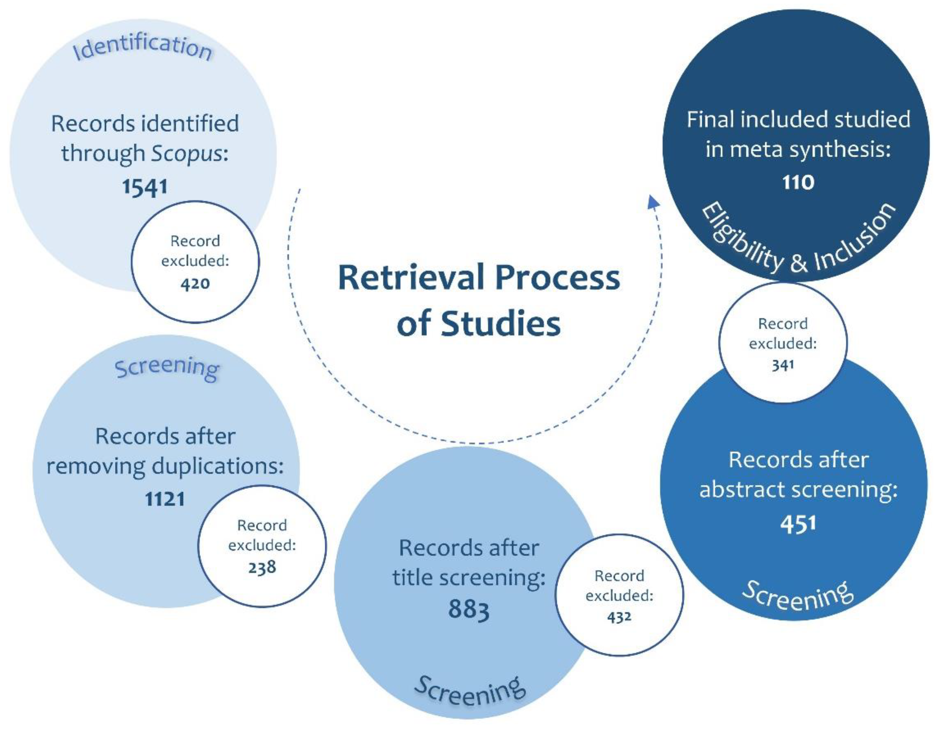
2. Materials and Methods
- Study timeline: number of papers
- The co-occurrence of fundamental concepts and methodological rules.
- Journal specialisation and distribution: publications, citations, average citation/publication
- Methodological approach: Type of methods, data collection, data analysis, and analytical software.
- Theme of studies: Thematic framework, dimensions and frequency.
3. Results
3.1. Timeline of Studies
3.2. Primary Concept and Methodological Codes
3.3. Leading Journals
3.4. Methodological Approach
3.5. The Study Themes: Driving Factors of LULCC
4. Discussion
4.1. The Interacting Model
4.2. Urban Growth Factors
4.2.1. Transport Infrastructure
4.2.2. Accessibility
4.2.3. Industrial Development
4.2.4. Residential Development
4.3. Policy and Regulation Factors
4.3.1. Urban/land Use Policies
4.3.2. Regulations
4.4. Economic and Financial Factors
4.4.1. Urban Economy
4.4.2. Investment
4.5. Contextual Factors
4.5.1. Demographic
4.5.2. Socio-Economic Features
4.5.3. Environment and Natural Resources
5. Conclusions
Author Contributions
Funding
Data Availability Statement
Acknowledgments
Conflicts of Interest
References
- Wu, H.; Lin, A.; Xing, X.; Song, D.; Li, Y. Identifying core driving factors of urban land use change from global land cover products and POI data using the random forest method. Int. J. Appl. Earth Obs. Geoinf. 2021, 103, 102475. [Google Scholar] [CrossRef]
- Dou, P.; Han, Z. Quantifying Land Use/Land Cover Change and Urban Expansion in Dongguan, China, From 1987 to 2020. IEEE J. Sel. Top. Appl. Earth Obs. Remote Sens. 2021, 15, 201–209. [Google Scholar] [CrossRef]
- Feng, R.; Wang, K. Spatiotemporal effects of administrative division adjustment on urban expansion in China. Land Use Policy 2021, 101, 105143. [Google Scholar] [CrossRef]
- Li, M.; Verburg, P.H.; van Vliet, J. Global trends and local variations in land take per person. Landsc. Urban Plan. 2022, 218, 104308. [Google Scholar] [CrossRef]
- Tavares, A.O.; Monteiro, M.; Barros, J.L.; Santos, P.P. Long-term land-use changes in small/medium-sized cities. Enhancing the general trends and local characteristics. Eur. Plan. Stud. 2019, 27, 1432–1459. [Google Scholar] [CrossRef] [Green Version]
- Nagy, R.; Lockaby, B.G. Urbanization in the Southeastern United States: Socioeconomic forces and ecological responses along an urban-rural gradient. Urban Ecosyst. 2011, 14, 71–86. [Google Scholar] [CrossRef]
- Tiitu, M. Expansion of the built-up areas in Finnish city regions–The approach of travel-related urban zones. Appl. Geogr. 2018, 101, 1–13. [Google Scholar] [CrossRef]
- Banzhaf, E.; Reyes-Paecke, S.; Müller, A.; Kindler, A. Do demographic and land-use changes contrast urban and suburban dynamics? A sophisticated reflection on Santiago de Chile. Habitat Int. 2013, 39, 179–191. [Google Scholar] [CrossRef]
- De la Luz Hernández-Flores, M.; Otazo-Sánchez, E.M.; Galeana-Pizana, M.; Roldán-Cruz, E.I.; Razo-Zárate, R.; González-Ramírez, C.A.; Galindo-Castillo, E.; Gordillo-Martínez, A.J. Urban driving forces and megacity expansion threats. Study case in the Mexico City periphery. Habitat Int. 2017, 64, 109–122. [Google Scholar] [CrossRef]
- Xu, Y.; McNamara, P.; Wu, Y.; Dong, Y. An econometric analysis of changes in arable land utilization using multinomial logit model in Pinggu district, Beijing, China. J. Environ. Manag. 2013, 128, 324–334. [Google Scholar] [CrossRef]
- Kleemann, J.; Inkoom, J.N.; Thiel, M.; Shankar, S.; Lautenbach, S.; Fürst, C. Peri-urban land use pattern and its relation to land use planning in Ghana, West Africa. Landsc. Urban Plan. 2017, 165, 280–294. [Google Scholar] [CrossRef]
- Islam, M.D.; Islam, K.S.; Ahasan, R.; Mia, M.R.; Haque, M.E. A data-driven machine learning-based approach for urban land cover change modeling: A case of Khulna City Corporation area. Remote Sens. Appl. Soc. Environ. 2021, 24, 100634. [Google Scholar] [CrossRef]
- Essien, E.; Cyrus, S. Detection of urban development in Uyo (Nigeria) using remote sensing. Land 2019, 8, 102. [Google Scholar] [CrossRef] [Green Version]
- Hasan, S.; Shi, W.; Zhu, X.; Abbas, S. Monitoring of land use/land cover and socioeconomic changes in south china over the last three decades using landsat and nighttime light data. Remote Sens. 2019, 11, 1658. [Google Scholar] [CrossRef] [Green Version]
- Ponstingel, D. The impact of exurban development on forested areas in Kurgan City, Russia. Land Use Policy 2020, 94, 104485. [Google Scholar] [CrossRef]
- Colsaet, A.; Laurans, Y.; Levrel, H. What drives land take and urban land expansion? A systematic review. Land Use Policy 2018, 79, 339–349. [Google Scholar] [CrossRef]
- Zhang, Q.; Seto, K.C. Mapping urbanization dynamics at regional and global scales using multi-temporal DMSP/OLS nighttime light data. Remote Sens. Environ. 2011, 115, 2320–2329. [Google Scholar] [CrossRef]
- Li, W.; Wu, C.; Zang, S. Modeling urban land use conversion of Daqing City, China: A comparative analysis of “top-down” and “bottom-up” approaches. Stoch. Environ. Res. Risk Assess. 2014, 28, 817–828. [Google Scholar] [CrossRef]
- Liu, Y.; Song, W.; Deng, X. Understanding the spatiotemporal variation of urban land expansion in oasis cities by integrating remote sensing and multi-dimensional DPSIR-based indicators. Ecol. Indic. 2019, 96, 23–37. [Google Scholar] [CrossRef]
- Li, H.; Wei, Y.D.; Liao, F.H.; Huang, Z. Administrative hierarchy and urban land expansion in transitional China. Appl. Geogr. 2015, 56, 177–186. [Google Scholar] [CrossRef]
- Kontgis, C.; Schneider, A.; Fox, J.; Saksena, S.; Spencer, J.H.; Castrence, M. Monitoring peri-urbanization in the greater Ho Chi Minh City metropolitan area. Appl. Geogr. 2014, 53, 377–388. [Google Scholar] [CrossRef]
- Dai, E.; Wu, Z.; Du, X. A gradient analysis on urban sprawl and urban landscape pattern between 1985 and 2000 in the Pearl River Delta, China. Front. Earth Sci. 2018, 12, 791–807. [Google Scholar] [CrossRef]
- Asabere, S.B.; Acheampong, R.A.; Ashiagbor, G.; Beckers, S.C.; Keck, M.; Erasmi, S.; Schanze, J.; Sauer, D. Urbanization, land use transformation and spatio-environmental impacts: Analyses of trends and implications in major metropolitan regions of Ghana. Land Use Policy 2020, 96, 104707. [Google Scholar] [CrossRef]
- Shahraki, S.Z.; Sauri, D.; Serra, P.; Modugno, S.; Seifolddini, F.; Pourahmad, A. Urban sprawl pattern and land-use change detection in Yazd, Iran. Habitat Int. 2011, 35, 521–528. [Google Scholar] [CrossRef]
- Kamh, S.; Ashmawy, M.; Kilias, A.; Christaras, B. Evaluating urban land cover change in the Hurghada area, Egypt, by using GIS and remote sensing. Int. J. Remote Sens. 2012, 33, 41–68. [Google Scholar] [CrossRef]
- Moghadam, H.S.; Helbich, M. Spatiotemporal urbanization processes in the megacity of Mumbai, India: A Markov chains-cellular automata urban growth model. Appl. Geogr. 2013, 40, 140–149. [Google Scholar] [CrossRef]
- Jawarneh, R.N.; Julian, J.P.; Lookingbill, T.R. The influence of physiography on historical and future land development changes: A case study of central Arkansas (USA), 1857–2030. Landsc. Urban Plan. 2015, 143, 76–89. [Google Scholar] [CrossRef]
- Sunde, M.G.; He, H.S.; Zhou, B.; Hubbart, J.A.; Spicci, A. Imperviousness Change Analysis Tool (I-CAT) for simulating pixel-level urban growth. Landsc. Urban Plan. 2014, 124, 104–108. [Google Scholar] [CrossRef]
- Gerten, C.; Fina, S.; Rusche, K. The sprawling planet: Simplifying the measurement of global urbanization trends. Front. Environ. Sci. 2019, 7, 140. [Google Scholar] [CrossRef]
- Han, Y.; Jia, H. Simulating the spatial dynamics of urban growth with an integrated modeling approach: A case study of Foshan, China. Ecol. Model. 2017, 353, 107–116. [Google Scholar] [CrossRef]
- Feng, Y. Modeling dynamic urban land-use change with geographical cellular automata and generalized pattern search-optimized rules. Int. J. Geogr. Inf. Sci. 2017, 31, 1198–1219. [Google Scholar] [CrossRef]
- Kong, L.; Tian, G.; Ma, B.; Liu, X. Embedding ecological sensitivity analysis and new satellite town construction in an agent-based model to simulate urban expansion in the beijing metropolitan region, China. Ecol. Indic. 2017, 82, 233–249. [Google Scholar] [CrossRef]
- Leyk, S.; Uhl, J.H.; Connor, D.S.; Braswell, A.E.; Mietkiewicz, N.; Balch, J.K.; Gutmann, M. Two centuries of settlement and urban development in the United States. Sci. Adv. 2020, 6, eaba2937. [Google Scholar] [CrossRef] [PubMed]
- Bajracharya, P.; Lippitt, C.D.; Sultana, S. Modeling urban growth and land cover change in Albuquerque using SLEUTH. Prof. Geogr. 2020, 72, 181–193. [Google Scholar] [CrossRef]
- Quesada-Román, A.; Castro-Chacón, J.P.; Feoli Boraschi, S. Geomorphology, land use, and environmental impacts in a densely populated urban catchment of Costa Rica. J. S. Am. Earth Sci. 2021, 112, 103560. [Google Scholar] [CrossRef]
- Quesada-Román, A.; Mata-Cambronero, E. The geomorphic landscape of the Barva volcano, Costa Rica. Phys. Geogr. 2021, 42, 265–282. [Google Scholar] [CrossRef]
- García-Soriano, D.; Quesada-Román, A.; Zamorano-Orozco, J.J. Geomorphological hazards susceptibility in high-density urban areas: A case study of Mexico City. J. S. Am. Earth Sci. 2020, 102, 102667. [Google Scholar] [CrossRef]
- Winsemius, H.C.; Aerts, J.C.; Van Beek, L.P.; Bierkens, M.F.; Bouwman, A.; Jongman, B.; Kwadijk, J.C.J.; Ligtvoet, W.; Lucas, P.L.; van Vuuren, D.P.; et al. Global drivers of future river flood risk. Nat. Clim. Change 2016, 6, 381–385. [Google Scholar] [CrossRef]
- Shah, M.A.R.; Rahman, A.; Chowdhury, S.H. Challenges for achieving sustainable flood risk management. J. Flood Risk Manag. 2018, 11, S352–S358. [Google Scholar] [CrossRef] [Green Version]
- Nassar, A.K.; Blackburn, G.A.; Whyatt, J.D. Developing the desert: The pace and process of urban growth in Dubai. Comput. Environ. Urban Syst. 2014, 45, 50–62. [Google Scholar] [CrossRef] [Green Version]
- Wang, J.; Lin, Y.; Glendinning, A.; Xu, Y. Land-use changes and land policies evolution in China’s urbanization processes. Land Use Policy 2018, 75, 375–387. [Google Scholar] [CrossRef]
- Feng, R.; Wang, K. The direct and lag effects of administrative division adjustment on urban expansion patterns in Chinese mega-urban agglomerations. Land Use Policy 2022, 112, 105805. [Google Scholar] [CrossRef]
- Yue, W.; Fan, P.; Wei, Y.D.; Qi, J. Economic development, urban expansion, and sustainable development in Shanghai. Stoch. Environ. Res. Risk Assess. 2014, 28, 783–799. [Google Scholar] [CrossRef]
- Schumacher, M.; Durán-Díaz, P.; Kurjenoja, A.K.; Gutiérrez-Juárez, E.; González-Rivas, D.A. Evolution and Collapse of Ejidos in Mexico—To What Extent Is Communal Land Used for Urban Development? Land 2019, 8, 146. [Google Scholar] [CrossRef] [Green Version]
- Whiteside, H. Privatizing Canadian government land and real estate: Railroads, reconciliation, and rip-offs. Land Use Policy 2020, 99, 104821. [Google Scholar] [CrossRef]
- Tong, D.; Wang, X.; Wu, L.; Zhao, N. Land ownership and the likelihood of land development at the urban fringe: The case of Shenzhen, China. Habitat Int. 2018, 73, 43–52. [Google Scholar] [CrossRef]
- Adam, A.G. Thinking outside the box and introducing land readjustment against the conventional urban land acquisition and delivery method in Ethiopia. Land Use Policy 2019, 81, 624–631. [Google Scholar] [CrossRef]
- Zhang, S.; De Roo, G.; Van Dijk, T. Urban land changes as the interaction between self-organization and institutions. Plan. Pract. Res. 2015, 30, 160–178. [Google Scholar] [CrossRef]
- Li, X.; Zhou, W.; Ouyang, Z. Forty years of urban expansion in Beijing: What is the relative importance of physical, socioeconomic, and neighborhood factors? Appl. Geogr. 2013, 38, 1–10. [Google Scholar] [CrossRef]
- Plieninger, T.; Draux, H.; Fagerholm, N.; Bieling, C.; Bürgi, M.; Kizos, T.; Kuemmerle, T.; Primdahl, J.; Verburg, P.H. The driving forces of landscape change in Europe: A systematic review of the evidence. Land Use Policy 2016, 57, 204–214. [Google Scholar] [CrossRef] [Green Version]
- Yang, G.; Chao, S.; Tsou, J.Y.; Zhang, Y. Satellite image-based methods of spatiotemporal analysis on sustainable urban land use change and the driving factors: A case study in caofeidian and the suburbs, China. Sustainability 2019, 11, 2927. [Google Scholar] [CrossRef] [Green Version]
- Cai, Y.; Zhang, H.; Pan, W.; Chen, Y.; Wang, X. Urban expansion and its influencing factors in natural wetland distribution area in Fuzhou City, China. Chin. Geogr. Sci. 2012, 22, 568–577. [Google Scholar] [CrossRef]
- Dadashpoor, H.; Malekzadeh, N. Driving factors of formation, development, and change of spatial structure in metropolitan areas: A systematic review. J. Urban Manag. 2020, 9, 286–297. [Google Scholar] [CrossRef]
- Thelwall, M. Bibliometrics to webometrics. J. Inf. Sci. 2008, 34, 605–621. [Google Scholar] [CrossRef]
- Dzikowski, P. A bibliometric analysis of born global firms. J. Bus. Res. 2018, 85, 281–294. [Google Scholar] [CrossRef]
- Zhang, Y.; Xu, B. Spatiotemporal analysis of land use/cover changes in Nanchang area, China. Int. J. Digit. Earth 2015, 8, 312–333. [Google Scholar] [CrossRef]
- Chen, T.; Lang, W.; Chan, E.; Philipp, C.H. Lhasa: Urbanising China in the frontier regions. Cities 2018, 74, 343–353. [Google Scholar] [CrossRef]
- Li, Y.; Li, Y.; Karácsonyi, D.; Liu, Z.; Wang, Y.; Wang, J. Spatio-temporal pattern and driving forces of construction land change in a poverty-stricken county of China and implications for poverty-alleviation-oriented land use policies. Land Use Policy 2020, 91, 104267. [Google Scholar] [CrossRef]
- Xu, F.; Wang, Z.; Chi, G.; Zhang, Z. The impacts of population and agglomeration development on land use intensity: New evidence behind urbanization in China. Land Use Policy 2020, 95, 104639. [Google Scholar] [CrossRef]
- Bimonte, S.; Stabile, A. Local taxation and urban development. Testing for the side-effects of the Italian property tax. Ecol. Econ. 2015, 120, 100–107. [Google Scholar] [CrossRef]
- Kuang, W. National urban land-use/cover change since the beginning of the 21st century and its policy implications in China. Land Use Policy 2020, 97, 104747. [Google Scholar] [CrossRef]
- Wadduwage, S. Peri-urban agricultural land vulnerability due to urban sprawl–a multi-criteria spatially-explicit scenario analysis. J. Land Use Sci. 2018, 13, 358–374. [Google Scholar] [CrossRef] [Green Version]
- Gallardo, M.; Martínez-Vega, J. Three decades of land-use changes in the region of Madrid and how they relate to territorial planning. Eur. Plan. Stud. 2016, 24, 1016–1033. [Google Scholar] [CrossRef] [Green Version]
- Simwanda, M.; Murayama, Y.; Ranagalage, M. Modeling the drivers of urban land use changes in Lusaka, Zambia using multi-criteria evaluation: An analytic network process approach. Land Use Policy 2020, 92, 104441. [Google Scholar] [CrossRef]
- Peng, K.; Jiang, W.; Ling, Z.; Hou, P.; Deng, Y. Evaluating the potential impacts of land use changes on ecosystem service value under multiple scenarios in support of SDG reporting: A case study of the Wuhan urban agglomeration. J. Clean. Prod. 2021, 307, 127321. [Google Scholar] [CrossRef]
- Inouye, C.E.N.; de Sousa Jr, W.C.; De Freitas, D.M.; Simões, E. Modelling the spatial dynamics of urban growth and land use changes in the north coast of São Paulo, Brazil. Ocean. Coast. Manag. 2015, 108, 147–157. [Google Scholar] [CrossRef]
- Hamnett, C. Is Chinese urbanization unique? Urban Stud. 2020, 57, 690–700. [Google Scholar] [CrossRef]
- Shin, H.; Chae, S. Urbanisation and land use transition in a second-tier city: The emergence of small factories in Gimpo, South Korea. Land Use Policy 2018, 77, 534–541. [Google Scholar] [CrossRef]
- Pratama, A.P.; Yudhistira, M.H.; Koomen, E. Highway expansion and urban sprawl in the Jakarta Metropolitan Area. Land Use Policy 2022, 112, 105856. [Google Scholar] [CrossRef]
- Cheng, L. China’s rural transformation under the Link Policy: A case study from Ezhou. Land Use Policy 2021, 103, 105319. [Google Scholar] [CrossRef]
- Cao, W.; Zhou, Y.; Li, R.; Li, X.; Zhang, H. Monitoring long-term annual urban expansion (1986–2017) in the largest archipelago of China. Sci. Total Environ. 2021, 776, 146015. [Google Scholar] [CrossRef]
- Wenner, F.; Thierstein, A. High speed rail as urban generator? An analysis of land use change around European stations. Eur. Plan. Stud. 2022, 30, 227–250. [Google Scholar] [CrossRef]
- Deng, Y.; Srinivasan, S. Urban land use change and regional access: A case study in Beijing, China. Habitat Int. 2016, 51, 103–113. [Google Scholar] [CrossRef]
- Ahmad, S.; Avtar, R.; Sethi, M.; Surjan, A. Delhi’s land cover change in post transit era. Cities 2016, 50, 111–118. [Google Scholar] [CrossRef]
- Hurst, N.B.; West, S.E. Public transit and urban redevelopment: The effect of light rail transit on land use in Minneapolis, Minnesota. Reg. Sci. Urban Econ. 2014, 46, 57–72. [Google Scholar] [CrossRef]
- Wang, J.; Feng, Y.; Ye, Z.; Tong, X.; Wang, R.; Gao, C.; Chen, S.; Lei, Z.; Liu, S.; Jin, Y. Simulating the effect of urban light rail transit on urban development by coupling cellular automata and conjugate gradients. Geocarto Int. 2022, 37, 2346–2364. [Google Scholar] [CrossRef]
- Nguyen, H.A.; Soltani, A.; Allan, A. Adelaide’s East End tramline: Effects on modal shift and carbon reduction. Travel Behav. Soc. 2018, 11, 21–30. [Google Scholar] [CrossRef]
- Abdi, M.H.; Soltani, A. Which Fabric/Scale Is Better for Transit-Oriented Urban Design: Case Studies in a Developing Country. Sustainability 2022, 14, 7338. [Google Scholar] [CrossRef]
- Wang, K.; Zhou, W. Do local factors or teleconnections control urbanization? The shifting balance in a Chinese megaregion. Landsc. Urban Plan. 2018, 180, 179–186. [Google Scholar] [CrossRef]
- Meyer, M.A.; Früh-Müller, A. Patterns and drivers of recent agricultural land-use change in Southern Germany. Land Use Policy 2020, 99, 104959. [Google Scholar] [CrossRef]
- Chu, L.; Zou, Y.; Masiliūnas, D.; Blaschke, T.; Verbesselt, J. Assessing the impact of bridge construction on the land use/cover and socio-economic indicator time series: A case study of Hangzhou Bay Bridge. GISci. Remote Sens. 2021, 58, 199–216. [Google Scholar] [CrossRef]
- Zhao, L.; Shen, L. The impacts of rail transit on future urban land use development: A case study in Wuhan, China. Transp. Policy 2019, 81, 396–405. [Google Scholar] [CrossRef]
- McGarigal, K.; Plunkett, E.B.; Willey, L.L.; Compton, B.W.; DeLuca, W.V.; Grand, J. Modeling non-stationary urban growth: The SPRAWL model and the ecological impacts of development. Landsc. Urban Plan. 2018, 177, 178–190. [Google Scholar] [CrossRef]
- Nadafianshahamabadi, R.; Tayarani, M.; Rowangould, G. A closer look at urban development under the emergence of autonomous vehicles: Traffic, land use and air quality impacts. J. Transp. Geogr. 2021, 94, 103113. [Google Scholar] [CrossRef]
- Liu, D.; Clarke, K.C.; Chen, N. Integrating spatial nonstationarity into SLEUTH for urban growth modeling: A case study in the Wuhan metropolitan area. Comput. Environ. Urban Syst. 2020, 84, 101545. [Google Scholar] [CrossRef]
- Kasraian, D.; Raghav, S.; Miller, E.J. A multi-decade longitudinal analysis of transportation and land use co-evolution in the Greater Toronto-Hamilton Area. J. Transp. Geogr. 2020, 84, 102696. [Google Scholar] [CrossRef]
- Fitawok, M.B.; Derudder, B.; Minale, A.S.; Van Passel, S.; Adgo, E.; Nyssen, J. Modeling the impact of urbanization on land-use change in Bahir Dar City, Ethiopia: An integrated cellular Automata–Markov Chain Approach. Land 2020, 9, 115. [Google Scholar] [CrossRef] [Green Version]
- Daunt, A.B.P.; Inostroza, L.; Hersperger, A.M. The role of spatial planning in land change: An assessment of urban planning and nature conservation efficiency at the southeastern coast of Brazil. Land Use Policy 2021, 111, 105771. [Google Scholar] [CrossRef]
- Deslatte, A.; Szmigiel-Rawska, K.; Tavares, A.F.; Ślawska, J.; Karsznia, I.; Łukomska, J. Land use institutions and social-ecological systems: A spatial analysis of local landscape changes in Poland. Land Use Policy 2022, 114, 105937. [Google Scholar] [CrossRef]
- La, K.; Kumar, D.; Kumar, A. Spatio-temporal landscape modeling of urban growth patterns in Dhanbad Urban Agglomeration, India using geoinformatics techniques. Egypt. J. Remote Sens. Space Sci. 2017, 20, 91–102. [Google Scholar] [CrossRef]
- Ma, Q. Integrating ecological correlation into cellular automata for urban growth simulation: A case study of Hangzhou, China. Urban For. Urban Green. 2020, 51, 126697. [Google Scholar] [CrossRef]
- Hanlon, B.; Howland, M.; McGuire, M.P. Hotspots for Growth: Does Maryland’s Priority Funding Area Program Reduce Sprawl? J. Am. Plan. Assoc. 2012, 78, 256–268. [Google Scholar] [CrossRef]
- Sandhya Kiran, G.; Joshi, U.B. Estimation of variables explaining urbanization concomitant with land-use change: A spatial approach. Int. J. Remote Sens. 2013, 34, 824–847. [Google Scholar] [CrossRef]
- Geymen, A. Impacts of Bosporus bridges on the Istanbul metropolitan settlement areas. Land Degrad. Dev. 2013, 24, 156–169. [Google Scholar] [CrossRef]
- Jokar Arsanjani, J.; Helbich, M.; Vaz, E.D.N. Spatiotemporal simulation of urban growth patterns using agent-based modeling: The case of Tehran. Cities 2013, 32, 33–42. [Google Scholar] [CrossRef]
- Moghadam, A.S.; Soltani, A.; Parolin, B.; Alidadi, M. Analysing the space-time dynamics of urban structure change using employment density and distribution data. Cities. 2018, 81, 203–213. [Google Scholar] [CrossRef]
- Kang, S.; Choi, J.; Yoon, H.; Choi, W. Changes in the extent and distribution of urban land cover in the Democratic People’s Republic of Korea (North Korea) between 1987 and 2010. Land Degrad. Dev. 2019, 30, 2009–2017. [Google Scholar] [CrossRef]
- Zambon, I.; Cerdà, A.; Gambella, F.; Egidi, G.; Salvati, L. Industrial sprawl and residential housing: Exploring the interplay between local development and land-use change in the Valencian Community, Spain. Land 2019, 8, 143. [Google Scholar] [CrossRef] [Green Version]
- Luo, J.; Xing, X.; Wu, Y.; Zhang, W.; Chen, R.S. Spatio-temporal analysis on built-up land expansion and population growth in the Yangtze River Delta Region, China: From a coordination perspective. Appl. Geogr. 2018, 96, 98–108. [Google Scholar] [CrossRef]
- UI Din, S.; Mak, H.W.L. Retrieval of Land-Use/Land Cover Change (LUCC) Maps and Urban Expansion Dynamics of Hyderabad, Pakistan via Landsat Datasets and Support Vector Machine Framework. Remote Sens. 2021, 13, 3337. [Google Scholar] [CrossRef]
- Dong, Y.; Ren, Z.; Fu, Y.; Miao, Z.; Yang, R.; Sun, Y.; He, X. Recording urban land dynamic and its effects during 2000–2019 at 15-m resolution by cloud computing with Landsat series. Remote Sens. 2020, 12, 2451. [Google Scholar] [CrossRef]
- Li, W.; Wang, D.; Li, H.; Liu, S. Urbanization-induced site condition changes of peri-urban cultivated land in the black soil region of northeast China. Ecol. Indic. 2017, 80, 215–223. [Google Scholar] [CrossRef]
- Xu, Y.; Chan, E.H.; Yung, E.H. Overwhelming farmland conversion for urban development in transitional China: Case study of Shanghai. J. Urban Plan. Dev. 2015, 141, 05014013. [Google Scholar] [CrossRef]
- Kong, F.; Yin, H.; Nakagoshi, N.; James, P. Simulating urban growth processes incorporating a potential model with spatial metrics. Ecol. Indic. 2012, 20, 82–91. [Google Scholar] [CrossRef]
- Soria, K.Y.; Palacios, M.R.; Gomez, C.A.M. Governance and policy limitations for sustainable urban land planning. The case of Mexico. J. Environ. Manag. 2020, 259, 109575. [Google Scholar] [CrossRef] [PubMed]
- Soltani, A.; Hosseinpour, M.; Hajizadeh, A. Urban sprawl in Iranian medium-sized cities; investigating the Role of Masterplans. J. Sustain. Dev. 2017, 10, 122–131. [Google Scholar] [CrossRef]
- Lopez, J.C.G.; Arnott, R.J. Is higher-quality land developed earlier? Environ. Plan. B Urban Anal. City Sci. 2020, 47, 1560–1572. [Google Scholar] [CrossRef] [Green Version]
- Magliocca, N.; McConnell, V.; Walls, M. Exploring sprawl: Results from an economic agent-based model of land and housing markets. Ecol. Econ. 2015, 113, 114–125. [Google Scholar] [CrossRef]
- Hu, S.; Cheng, Q.; Wang, L.; Xie, S. Multifractal characterization of urban residential land price in space and time. Appl. Geogr. 2012, 34, 161–170. [Google Scholar] [CrossRef]
- Sang, X.; Guo, Q.; Wu, X.; Fu, Y.; Xie, T.; He, C.; Zang, J. Intensity and stationarity analysis of land use change based on CART algorithm. Sci. Rep. 2019, 9, 12279. [Google Scholar] [CrossRef] [Green Version]
- Admasu, T.G. Urban land use dynamics, the nexus between land use pattern and its challenges: The case of Hawassa city, Southern Ethiopia. Land Use Policy 2015, 45, 159–175. [Google Scholar] [CrossRef]
- Skog, K.L.; Steinnes, M. How do centrality, population growth and urban sprawl impact farmland conversion in Norway? Land Use Policy 2016, 59, 185–196. [Google Scholar] [CrossRef]
- Fuglsang, M.; Münier, B.; Hansen, H.S. Modelling land-use effects of future urbanization using cellular automata: An Eastern Danish case. Environ. Model. Softw. 2013, 50, 1–11. [Google Scholar] [CrossRef]
- Jiang, L.; Deng, X.; Seto, K.C. The impact of urban expansion on agricultural land use intensity in China. Land Use Policy 2013, 35, 33–39. [Google Scholar] [CrossRef]
- Gong, J.; Chen, W.; Liu, Y.; Wang, J. The intensity change of urban development land: Implications for the city master plan of Guangzhou, China. Land Use Policy 2014, 40, 91–100. [Google Scholar] [CrossRef]
- Tomao, A.; Quaranta, G.; Salvia, R.; Vinci, S.; Salvati, L. Revisiting the ‘southern mood’? Post-crisis Mediterranean urbanities between economic downturns and land-use change. Land Use Policy 2021, 111, 105740. [Google Scholar] [CrossRef]
- Salvati, L. Urban dispersion and economic crisis: Empirical evidence from a Mediterranean region. J. Environ. Plan. Manag. 2019, 62, 1205–1226. [Google Scholar] [CrossRef]
- Mustafa, A.; Bruwier, M.; Archambeau, P.; Erpicum, S.; Pirotton, M.; Dewals, B.; Jacques Teller, J. Effects of spatial planning on future flood risks in urban environments. J. Environ. Manag. 2018, 225, 193–204. [Google Scholar] [CrossRef]
- Santos, P.P.; Pereira, S.; Zêzere, J.L.; Tavares, A.O.; Reis, E.; Garcia, R.A.C.; Oliveira, S.C. A comprehensive approach to understanding flood risk drivers at the municipal level. J. Environ. Manag. 2020, 260, 110127. [Google Scholar] [CrossRef]
- Yan, D.; Schneider, U.A.; Schmid, E.; Huang, H.Q.; Pan, L.; Dilly, O. Interactions between land use change, regional development, and climate change in the Poyang Lake district from 1985 to 2035. Agric. Syst. 2013, 119, 10–21. [Google Scholar] [CrossRef]
- Soltani, A.; Sharifi, E. Daily variation of urban heat island effect and its correlations to urban greenery: A case study of Adelaide. Front. Archit. Res. 2017, 6, 529–538. [Google Scholar] [CrossRef]
- Azhdari, A.; Soltani, A.; Alidadi, M. Urban morphology and landscape structure effect on land surface temperature: Evidence from Shiraz, a semi-arid city. Sustain. Cities Soc. 2018, 41, 853–864. [Google Scholar] [CrossRef]
- Pan, H.; Page, J.; Cong, C.; Barthel, S.; Kalantari, Z. How ecosystems services drive urban growth: Integrating nature-based solutions. Anthropocene 2021, 35, 100297. [Google Scholar] [CrossRef]
- Soltani, A. Social and urban form determinants of vehicle ownership; evidence from a developing country, Transportation Research Part A: Policy and Practice. Transp. Res. Part A Policy Pract. 2017, 96, 90–100. [Google Scholar] [CrossRef]
- Han, H.; Yang, C.; Song, J. Scenario Simulation and the Prediction of Land Use and Land Cover Change in Beijing, China. Sustainability. 2015, 7, 4260–4279. [Google Scholar] [CrossRef] [Green Version]
- Azhdari, A.; Sasani, M.A.; Soltani, A. Exploring the relationship between spatial driving forces of urban expansion and socioeconomic segregation: The case of Shiraz, Habitat International. Habitat Int. 2018, 81, 33–44. [Google Scholar] [CrossRef]
- Abulibdeh, A.; Al-Awadhi, T.; Al-Barwani, M. Comparative analysis of the driving forces and spatiotemporal patterns of urbanisation in Muscat, Doha, and Dubai, Development in Practice. Dev. Pract. 2019, 29, 606–618. [Google Scholar] [CrossRef]


| Item | Sub-Item | Details |
|---|---|---|
| Keywords | Main keywords | Land Use Change, Land Cover Change, Land Use and Land Cover Change, Land Use/Land Cover Change, Land Use/Land Cover, Land Use, Land Cover |
| Supplemented Key-Words | Urban Growth, Urbanization, Urban Development, Urban Area, Urban Planning, Urban Sprawl, Urban Expansion, Expansion, Land Use Planning, Planning | |
| Operators | “OR”, “AND” | |
| Time period | 2012–2022 | |
| Language | English | |
| Document type | Journal paper | |
| Journal Title | Number of Papers | Number of Citations | Citation per Paper |
|---|---|---|---|
| Computers, Environment and Urban Systems | 34 | 381 | 11.21 |
| Ecological Indicators | 22 | 458 | 20.82 |
| Environmental Monitoring and Assessment | 22 | 227 | 10.32 |
| Land Use Policy | 22 | 621 | 28.23 |
| Landscape and Urban Planning | 19 | 745 | 39.21 |
| Remote Sensing | 17 | 241 | 14.18 |
| Science of the Total Environment | 14 | 992 | 70.86 |
| Sustainability | 12 | 593 | 49.42 |
| Research Approach | Number and Percentage of Papers | Data Collection Method | Data Analysis Method | Analytical Tools/Software (Some Examples) |
|---|---|---|---|---|
| Quantitative | 68 (62%) | Primary data | Spatial analysis; Spatiotemporal analysis & Simulation | -Cellular automata, SLUETH: [34] -Imperviousness Change Analysis Tool (I-CAT) and MCE: [28] -Satellite Image analysis: [40,56,57] |
| Statistical analysis | -Descriptive comparison: [13,58] - Regression analysis: [20,46,59,60] | |||
| Mixed (Spatial analysis, Statistical analysis & Descriptive analysis) | -Spatial auto-correlation: [61] -Scenario-building: [62] -IDRISI image analyser: [63] -MCE (ANP): [64] -Cellular automata [65,66] | |||
| Qualitative | 7 (6%) | Primary or | Descriptive analysis | -Narrative: [67] |
| Secondary data | -Case study research: [48] | |||
| Mixed (Primary and secondary data) | Qualitative content analysis | -Focus group discussion (FGD), Questionnaire survey and Interview: [47,68] -Systematic review: [16] | ||
| Mixed | 35 (32%) | Primary or secondary data | Spatial analysis and Statistical analysis | -Satellite image analysis and Regression analysis: Policy review [10,69] |
| Spatial analysis, Statistical analysis & Descriptive analysis | -Policy-analysis: [70] -Mixed method [71] | |||
| Mixed (Primary and secondary data) | Spatial analysis | -Principal component analysis (PCA): Policy review [5] | ||
| Mixed (Spatial analysis, Statistical analysis & Descriptive analysis) | -Cross-tabulation: [72] -Spatial Statistics and Logit Regression: Policy review [73] |
| Theme | Sub-Theme | Code (Factor) | Sample Studies | Frequency | Share |
|---|---|---|---|---|---|
| Urban growth factors | Transport infrastructure | Airport | Kamh et al. (2012); Banzhaf et al. (2013); Nassar et al. (2014); Chen et al. (2018); Essien & Cyrus (2019) | 5 | 4.55 |
| Bridge | Geymen (2013); Cao et al. (2021); Chu et al. (2021); Jawarneh et al. (2015); Han & Jia (2017) | 5 | 4.55 | ||
| High-speed rail | Zhang et al. (2020) | 1 | 0.91 | ||
| Highway | Feng & Wang (2021); Hanlon et al. (2012); Sandhya Kiran & Joshi (2013); Geymen (2013); Nassar et al. (2014); Jawarneh et al. (2015); Kong et al. (2017); Chen et al. (2018); Wang & Zhou (2018); Colsaet et al. (2018); Nadafianshahamabadi et al. (2021); Meyer & Früh-Müller (2020); Chu et al. (2021); Pratama et al. (2022); Schumacher et al. (2019); Inouye et al. (2015); Wu et al. (2021) | 17 | 15.47 | ||
| Light rail transit | Hurst, et al. (2014); Wang, et al. (2020); Wu, et al. (2021); Moghadam et al. (2018) | 3 | 3.64 | ||
| Railway | Feng & Wang (2021); Chu et al. (2021); Wang & Zhou, (2018); Chen et al. (2018); Kong et al. (2017); Jawameh et al. (2015); Zhang & Xu (2015); Li et al. (2014); Zhao & Shen (2019) | 9 | 8.19 | ||
| Road network | Nassar et al. (2014); Chen et al. (2018); Colsaet et al. (2018); McGarigal et al. (2018); Nadafianshahamabadi et al. (2021); Islam et al. (2021); Liu et al. (2020); Kasraian et al. (2020); Tavares et al. (2019); Sunde et al. (2014); Kontgis et al. (2014) Li et al. (2014); Fitawok et al. (2020); Bajracharya et al. (2020); Shafizadeh Moghadam & Helbich (2013); Xu et al. (2013); Jawarneh et al. (2015); Gallardo & Martinezvega (2016); de la Luz Hernández-Flores et al. (2017); Fen (2017); Kong et al. (2017); Essien & Cyrus (2019); Schumacher et al. (2019); Daunt et al. (2021); Deslatte et al. (2022); Lal et al. (2017); Inouye et al. (2015); Gerten et al. (2019); Ma, (2020); Leyk et al. (2020) | 30 | 27.30 | ||
| Subway and Subway station | Nassar et al. (2014); Feng & wang, (2021); Ahmad et al. (2016); Wu et al. (2021) | 4 | 3.64 | ||
| Traffic service | Wenner & Thierstein (2021); Wu et al. (2021); Wang & Zhou (2018); Deng & Srinivasan (2016) | 4 | 3.64 | ||
| Wharf | Cao et al. (2021); Nassar et al. (2014); Daunt et al. (2021); Inouye et al. (2015) | 4 | 3.64 | ||
| Train | Meyer & Früh-Müller (2020); Wu et al. (2021) | 2 | 1.82 | ||
| Industry | Technological progress and industrial transformation | Din & Mak (2021); Cao et al. (2021); Dong et al. (2020); Liu et al. (2019); Dai et al. (2018); Li et al. (2017); Kontgis et al. (2014); Nassar et al. (2014), Xu et al. (2013); Hasan et al. (2019); Wang et al. (2018); Li et al. (2014); Jawarneh et al. (2015); Leyk et al. (2020); Chu et al. (2021); Dou & Han (2021); Feng & Wang (2021); Tavares et al. (2019); Sandhya Kiran & Joshi (2013); Kleemann et al. (2017); de la Luz Hernández-Flores et al. (2017); Inouye et al. (2015) | 22 | 20.02 | |
| Industrial parks/sites | Cheng (2021), Kang et al. (2019), Zambon et al. (2019), Shin & Chae (2018), Han & Jia (2017), Zhang & Xu (2015) | 6 | 5.45 | ||
| Factories | Wu et al. (2021); Shin & Chae (2018); UI Din & Mak (2021) | 3 | 2.73 | ||
| Accessibility | Proximity to the city/county/megacity centre | Han & Jia (2017); Deng & Srinivasan (2016); Li et al. (2014); Lal et al. (2017); Wang & Zhou (2018); Fitawok et al. (2020); Nguyen et al. (2018) | 7 | 6.36 | |
| Commercial /leisure centre/park | Gallardo & Martinezvega (2016); Chen et al. (2018); Kong et al. (2017); Bajracharya et al. (2020); Han & Jia (2017); Wu et al. (2021) | 6 | 5.45 | ||
| Education and research | Wu et al. (2021); Liu et al. (2020); Cao et al. (2021); Li et al. (2015); de la Luz Hernández-Flores et al. (2017); Zhang & Xu, (2015) | 6 | 5.45 | ||
| Hotel | Chen et al. (2018); Essien & Cyrus, (2019); Wu et al. (2021) | 3 | 2.73 | ||
| Neighbouring effect | Luo et al. (2018) | 1 | 0.91 | ||
| Distance from built-up areas | Shafizadeh Moghadam & Helbich (2013); Xu et al. (2013) | 2 | 1.82 | ||
| Medical care | de la Luz Hernández-Flores et al. (2017); | 1 | 0/91 | ||
| Accessibility to public facilities | Han & Jia (2017); Kong et al. (2017) | 2 | 1.82 | ||
| Residence | Constructing residential settlements | Meyer & Früh-Müller, (2020); Ponstingel (2020); Baj Racharya et al. (2020); Sandhya Kiran & Joshi (2013) | 4 | 3.64 | |
| Policy and regulation factors | Urban/land use policies | Administrative division adjustment | Feng & Wang (2021); Feng & Wang (2022) | 2 | 1.82 |
| Urban administrative hierarchy | Dong et al. (2020); Li et al. (2015) | 2 | 1.82 | ||
| Local government policy | Xu et al. (2013); Nassar et al. (2014); Kontgis et al. (2014); Xu et al. (2015); Luo et al. (2018); Cheng, (2021); Meyer & Früh-Müller (2020); Ponstingel (2020); Wang et al. (2018); Wadduwage (2018); Deslatte et al. (2022); Dou & Han (2021); Dai et al. (2018); Yue et al. (2014); Cao et al. (2021); Kuang, (2020); Essien & Cyrus (2019); Gerten et al. (2019); Chen et al. (2018); Kong et al. (2012); Kleemann et al. (2017); Li et al. (2015) | 22 | 20.02 | ||
| Private enterprise | Hamnett (2020); Soria et al. (2020) | 2 | 1.82 | ||
| User (property owner, developers, real estate companies) | Deslatte et al. (2022); Fitawok et al. (2020); Soria et al. (2020); Colsaet et al. (2018); Zhang et al. (2015); Nassar et al. (2014) | 6 | 5.45 | ||
| Changing land ownership | Kleemann et al. (2017); Schumacher et al. (2019); Whiteside (2020); De Tong et al. (2018); Adam (2019); Zhang et al. (2015) | 6 | 5.45 | ||
| Zoning | Colsaet et al. (2018); McGarigal et al. (2018) | 2 | 1.82 | ||
| Land use policies | Daunt et al. (2021); Deslatte et al. (2022) | 2 | 1.82 | ||
| Developable land | Deslatte et al. (2022); Deng & Srinivasan (2016) | 2 | 1.82 | ||
| Regulations | Impact property tax | Bimonte & Stabile (2015); Deslatte et al. (2022); Colsaet et al. (2018); Kontgis et al. (2014) | 4 | 3.64 | |
| Municipalities regulation | Deslatte et al. (2022) | 1 | 0.91 | ||
| Urban planning regulation | Feng & Wang (2022); Fitawok et al. (2020); Dai et al. (2018); Yue et al. (2014); Banzhaf et al. (2013); Kong et al. (2012); Kong et al. (2017) | 7 | 6.36 | ||
| Regulation of residential Land use | Tiitu (2018); Daunt et al. (2021); Colsaet et al. (2018) | 3 | 2.73 | ||
| Economic and Financial factors | Investment | Foreign direct investment | Li et al. (2015); Kontgis et al. (2014); Dai et al. (2018); Asabere et al. (2020); Dou & Han (2021) | 5 | 4.55 |
| Investment attraction | Dou & Han (2021); Deslatte et al. (2022); Kuang (2020); Chen et al. (2018); Admaus (2015) | 5 | 4.55 | ||
| Urban Economy | Market power/incentives | Hamnett (2020); Chen et al. (2018); | 2 | 1.82 | |
| Land market | Simwanda et al. (2020); Yue et al. (2014) | 2 | 1.82 | ||
| Land price | Magliocca et al. (2015); Hasan et al. (2019) | 2 | 1.82 | ||
| Land price distribution | Hu et al. (2012); Hanlon et al. (2012) | 2 | 1.82 | ||
| Housing price | Magliocca et al. (2015); Daunt et al. (2021) | 2 | 1.82 | ||
| Tourism development | Kamh et al. (2012); Sang et al. (2019); Colsaet et al. (2018); Nassar et al. (2014); Chu et al. (2021); Daunt et al. (2021) | 6 | 5.46 | ||
| Economic opportunities (trade, industrial) | Simwanda et al. (2020); Tavares et al. (2019); Sandhya Kiran & Joshi (2013); Nguyen et al. (2018) | 4 | 3.64 | ||
| Contextual factors | Demographic | Rural population migration | Kleemann et al. (2017); Ul Din & Mak (2021); Cao et al. (2021); Islam et al. (2021); Asabere et al. (2020); Xu et al. (2020); Gerten et al. (2019); Essien & Cyrus (2019); Simwanda et al. (2020); Fitawok et al. (2020) | 10 | 9.1 |
| Labor migration | Shin & Chae, (2018); Essien & Cyrus (2019); Kleemann et al. (2017); Dai et al. (2018); Simwanda et al. (2020); Nassar et al. (2014); Sang et al. (2019); Azhdari et al. (2019) | 7 | 6.36 | ||
| Internal migration | Colsaet et al. (2018); Kang et al. (2019); Liu et al. (2019); Jawarneh. et al. (2015); Skog & Steinnes (2016); Kamh et al. (2012), Abulibdeh et al. (2019). | 6 | 5.45 | ||
| Increase in urban population | Li et al. (2022); Dou & Han (2022); Daunt et al. (2021); Din & Mak (2021); Cao et al. (2021); Leyk et al. (2020); Xu et al. (2020); Bajracharya et al. (2020); Fitawok et al. (2020); Gerten et al. (2019); Tavares et al. (2019); Luo et al. (2018); Kleemann et al. (2017); Skog & Steinnes (2016); Sandhya Kiran & Joshi (2013); Banzhaf et al. (2013); Li et al. (2014); Nassar et al. (2014); Sunde et al. (2014); Zhang & Xu (2015); Lal et al. (2017); de la Luz Hernández-Flores et al. (2017); Essien & Cyrus (2019); Essien & Cyrus (2018); Tiitu (2018); Jawarneh et al. (2015); Kamh et al. (2012); Colsaet et al. (2018) | 28 | 25.48 | ||
| Population density | Banzhaf et al. (2013); Lal et al. (2017); de la Luz Hernández-Flores et al. (2017); Xu et al. (2013); Liu et al. (2020); Meyer & Früh-Müller (2020) | 6 | 5.45 | ||
| Socio-economic features | Lifestyle | Kleemann et al. (2017) | 1 | 0.91 | |
| Gross Domestic Production (GDP) | Xu et al. (2013); Jiang et al. (2013); Li et al. (2014); Gong et al. (2014); Luo et al. (2018); Colsaet et al. (2018); Liu et al. (2019); Hasan et al. (2019); Dong et al. (2020); Kuang, (2020); Cao et al. (2021); Liu et al. (2020); Chu et al. (2021); Dou & Han (2021); Ul Din & Mak (2021) | 15 | 13.65 | ||
| Increased income | Hasan et al. (2019); Ponstingel (2020); Colsaet et al. (2018) | 3 | 2.73 | ||
| Economic downturn/unemployment rate | Meyer & Früh-Müller (2020); Tomao et al. (2021); Salvati (2019); Kang et al. (2019) | 4 | 3.64 | ||
| Environment and natural resources | Slope | Kamh et al. (2012); Shafizadeh Moghadam & Helbich (2013); Xu et al. (2013); Sunde et al. (2014); Han & Jia (2017); Kong et al. (2017); Wadduwage (2018); Wang & Zhou (2018); Colsaet et al. (2018); Liu et al. (2020); Fitawok et al. (2020); de la Luz Hernández-Flores et al. (2017); Wu et al. (2021); Gerten et al. (2019); Jawarneh et al. (2015) | 15 | 13.65 | |
| Elevation | Xu et al. (2013); Sunde et al. (2014); Han & Jia (2017); Wang & Zhou (2018); Liu et al. (2020); Wu et al. (2021); Gerten et al. (2019); Jawarneh et al. (2015) | 8 | 7.27 | ||
| Climate | Yan et al. (2013); Colsaet et al. (2018); Wang et al. (2018); Admaus (2015) | 4 | 3.64 | ||
| Geographical location | Hasan et al. (2019); Dai et al. (2018); Ul Din & Mak (2021); Kamh et al. (2012); Nguyen et al (2018) | 5 | 4.55 | ||
| Flood prone areas | Jawarneh et al. (2015) | 2 | 0.91 | ||
| Sea shoreline | Kamh et al. (2012); Leyk et al. (2020) | 2 | 1.82 | ||
| Distance from water | Han & Jia (2017); Feng (2017); Li et al. (2014); Shafizadeh Moghadam & Helbich (2013); Kong et al. (2017); Sunde et al. (2014); Colsaet et al. (2018); Deslatte et al. (2022); Leyk et al. (2020); Bajracharya et al. (2020) | 10 | 9.09 | ||
| Resource | Ma, (2020) | 1 | 0.91 | ||
| Oil resource | Li et al. (2014); Nassar et al. (2014); Daunt et al. (2021); Essien & Cyrus, (2019) | 4 | 3.64 | ||
| Mine | Lal et al. (2017); de la Luz Hernández-Flores et al. (2017); Wu et al. (2021) | 3 | 2.73 | ||
| Ecosystem services | Pan et al. (2021); Peng et al. (2021) | 2 | 1.82 |
Publisher’s Note: MDPI stays neutral with regard to jurisdictional claims in published maps and institutional affiliations. |
© 2022 by the authors. Licensee MDPI, Basel, Switzerland. This article is an open access article distributed under the terms and conditions of the Creative Commons Attribution (CC BY) license (https://creativecommons.org/licenses/by/4.0/).
Share and Cite
Allan, A.; Soltani, A.; Abdi, M.H.; Zarei, M. Driving Forces behind Land Use and Land Cover Change: A Systematic and Bibliometric Review. Land 2022, 11, 1222. https://doi.org/10.3390/land11081222
Allan A, Soltani A, Abdi MH, Zarei M. Driving Forces behind Land Use and Land Cover Change: A Systematic and Bibliometric Review. Land. 2022; 11(8):1222. https://doi.org/10.3390/land11081222
Chicago/Turabian StyleAllan, Andrew, Ali Soltani, Mohammad Hamed Abdi, and Melika Zarei. 2022. "Driving Forces behind Land Use and Land Cover Change: A Systematic and Bibliometric Review" Land 11, no. 8: 1222. https://doi.org/10.3390/land11081222
APA StyleAllan, A., Soltani, A., Abdi, M. H., & Zarei, M. (2022). Driving Forces behind Land Use and Land Cover Change: A Systematic and Bibliometric Review. Land, 11(8), 1222. https://doi.org/10.3390/land11081222