Article

Impact of Ecological Restoration Project on Water Conservation Function of Qilian Mountains Based on InVEST Model—A Case Study of the Upper Reaches of Shiyang River Basin

1
College of Geography and Environment Science, Northwest Normal University, Lanzhou 730070, China
2
Gansu Engineering Research Center of Land Use and Comprehension Consolidation, Lanzhou 730070, China
3
Key Laboratory of Resource Environment and Sustainable Development of Oasis, Lanzhou 730070, China
4
College of Social Development and Public Administration, Northwest Normal University, Lanzhou 730070, China
*
Author to whom correspondence should be addressed.
Land 2023, 12(10), 1850; https://doi.org/10.3390/land12101850
Submission received: 7 August 2023 / Revised: 1 September 2023 / Accepted: 16 September 2023 / Published: 28 September 2023

Abstract

:
Scientifically evaluating the influence of ecological restoration projects on the water conservation function (WCF) of regional ecosystems is the foundation for formulating regional ecological restoration policies and optimizing and adjusting ecological restoration projects. In this paper, we considered fully the runoff generation and confluence process in the Qilian Mountains with the actual situation of the basin and re-rated the parameter Z to improve the simulation accuracy of InVEST model. On this basis, the impact of ecological restoration project on the WCF in the upper reaches of Shiyang River Basin (SRB) in the eastern part of Qilian Mountains was quantified. The results showed that, on the whole, the water conservation depth (WCD) of forest land was the largest (138.5 mm) and that of cultivated land was the smallest (24.78 mm), while the water conservation coefficient of forest land was also the largest (93.36%) and that of unused land was the smallest (16.67%). From 1986 to 2018, the WCD showed an increasing trend in the upper reaches of SRB, among them, the WCD in the western tributaries increased faster than that in the eastern tributaries from 1986 to 2000. The significantly increased areas were mainly distributed in the middle reaches of the western tributaries and the river source areas of the eastern tributaries, while the significantly decreased areas were mainly distributed in the river source areas of the western tributaries and the cultivated land expansion area in the middle reaches of the eastern tributaries. From 2000 to 2018, the WCD of the eastern tributaries increased more than that of the western tributaries. The significantly increased areas were mainly distributed in the four eastern tributaries, and the significantly decreased areas were scattered in the middle and lower reaches of each tributary. From 1986 to 2000, the overall influence of land use change on the increase in WCD was negative, while the influence of climate and land use change on the increase in water conservation were both positive from 2000 to 2018. The influence of land use change on WCD was different in different tributaries. Among them, that of the western tributaries (except the Dongda River) was positive in two different periods, while that of the eastern tributaries (except the Xiying River) was changed from negative to positive. The implementation of ecological restoration project was one of the main reasons for the improvement of WCF in Qilian Mountains from 2000 to 2018, with a contribution of 9.04%. In the future, the protection and restoration of decreased areas of WCF should be strengthened, and the Z value determined in this paper is expected to be applied in the arid inland river basins of northwest China.

1. Introduction

The ability of an ecosystem to treat and regulate water is called water ecosystem service [1,2]. As one of the key functions of water ecosystem services [3], WCF refers to the process and ability of the ecosystem to keep water under a certain spacetime range and conditions [4,5,6,7,8], which not only maintains green water (precipitation stored in unsaturated soil of plant roots) [9] but also plays a sufficient role in flood storage, flood peak reduction, water purification and runoff regulation [10,11,12,13]. It is an important regulating function of ecosystem services [14].
The ecosystem water conservation capacity is closely related to land use/cover types and climate change [15]. In the past 50 years, 60% of global ecosystem services have been degraded by irrational land use [16], and a series of ecological problems have emerged, such as soil erosion, desertification, biodiversity reduction, and weakening water conservation capacity [17]. In China, since the reform and opening up in the late 1970s, rapid population growth and economic development have led to huge environmental problem [18] and have posed a serious threat to ecological security. In order to restore damaged ecosystems and improve ecosystem services, the Chinese government has launched a series of sustainable development projects [19,20,21,22,23,24,25,26]. Of these, The Grain for Green Project is one of the largest ecological restoration projects in China and the world [18,25,27,28,29,30]. It was introduced as a policy in 1999 but was formally implemented in western China in 2000. And it was implemented mainly in the upper reaches of rivers with the aim of increasing forest coverage and preventing soil erosion on sloping farmland [31]. Grassland protection project aims to slow down overgrazing, improve grassland productivity, reverse the serious trend of grassland degradation, and promote the balanced development of animal husbandry and regional ecological environment protection [25]. After the implementation of the ecological restoration project, the ecosystem has been significantly improved. Among them, the vegetation [32,33,34,35,36,37], the water and soil conservation function and biodiversity have been significantly improved [38,39], as well as the soil organic carbon content and soil carbon sequestration capacity [30,40,41,42,43] and the water yield and WCF have also been strengthened [10,11,44,45,46]. The continuous improvement of ecosystem service value promotes the sound development of regional ecological environment [14,28,43,47,48,49,50]. For the influence of ecosystem WCF, land use change directly affects ecosystem governance patterns and local ecohydrological processes [51]. Therefore, quantitative research on the response of WCF to land use change is an important measure and effective way to restore and protect the ecosystem structure [52].
As an important ecological functional area, the Qilian Mountains play an important role in biodiversity, water conservation and carbon sequestration [53,54]. The Shiyang River Basin (SRB) originates from the northern slope of the eastern Qilian Mountains and is located at the edge of the monsoon area and has a fragile ecosystem. As a runoff forming area, the change in WCF of the upper reaches directly affects the healthy development of downstream oases. Over the past few decades, under the influence of climate and human activities, the native vegetation in the upper reaches of SRB has been severely damaged, and the water conservation and carbon sequestration functions have been weakened [43]. Therefore, the Chinese government has formulated a series of ecological restoration policies since 1999, including protecting natural forests, constructing ecological public welfare forests, and returning farmland to forests, and some of them have been implemented in the Qilian Mountains [43]. But after the implementation of the project, the changes in WCF are still not very clear, which has become a bottleneck for the further optimization of ecological restoration policies. On this basis, we chose 3 years of data (1986, 2000 and 2018) to analyze the impact of the ecological restoration project on WCF; of these, the study area was most seriously affected by human impacts in 1986, and The Grain for Green Project was formally implemented in the western region in 2000, and the year of 2018 was used to reflect the changes of WCD after the implementation of the project.
The InVEST model (the Integrated Valuation of Ecosystem Services and Tradeoffs) is an open-source software model which is used to assess ecosystem services and ecological effects at spatial scales; it was developed by Stanford University, the University of Minnesota, the World Wide Fund for Nature and The Nature Conservancy [55]. When using the InVEST model for evaluating ecosystem WCF, it must be calibrated to ensure the applicability in different regions. In this paper, combined with the actual situation of the study area, we comprehensively consider the influence of the side-drainage potential flow and glacier runoff in calibrating the parameter Z to reduce the error in calculating the water conservation. This is one of the main innovation points of this paper. After re-rating the parameter Z, this paper has (1) quantified the impact of climate and land use change on the ecosystem water yield and the WCF in the upper reaches of SRB; (2) clarified the spatial distribution pattern of increasing, invariant and decreasing areas of WCF; and (3) scientific assessed the ecological effects of ecological restoration projects. It provided guidance for the formulation of ecosystem protection and ecological restoration policies in Qilian Mountains, and the Z value determined in this paper is expected to be used in the arid inland river basins of northwest China.

2. Material and Methods
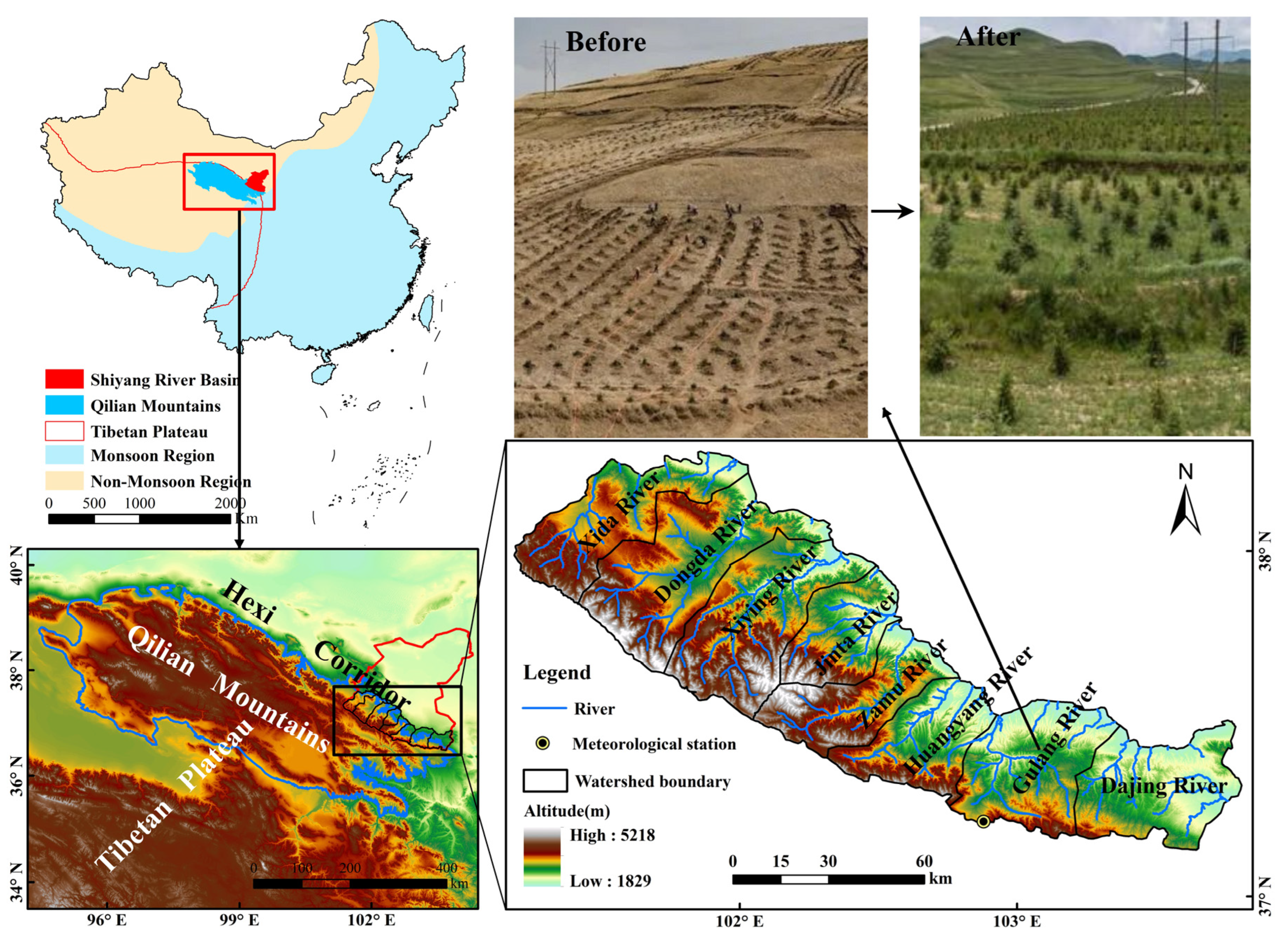
2.1. Study Area

The upper reaches of SRB (101°41′–103°48′ E, 36°29′–38°18′ N) is located in the inland area of northwest China, with an altitude of 1826–5200 m and drainage area of 1.15 × 10⁴ km2. It is under an alpine semi-arid, semi-humid climate, with a mean annual temperature of −2–6 °C, an annual precipitation of 344–538 mm, and the potential evapotranspiration of 890–1000 mm. The precipitation decreases from west to east. The area consists of eight tributaries from west to east, namely, the Xida River (XDR), the Dongda River (DDR), the Xiying River (XYR), the Jinta River (JTR), the Zamu River (ZMR), the Huangyang River (HYR), the Gulang River (GLR) and the Dajing River (DJR) (Figure 1). Atmospheric precipitation in the mountain is the main source of runoff recharge, accounting for about 60–70% of the total [56]. And Lenglongling glacial meltwater is also an important source of the runoff, which accounts for about 3.7% [57]. The vertical variations of hydrothermal conditions drive obvious distribution characteristics of vegetation zone, with transitions from mountain desert steppe (1800–2300 m), mountain steppe (2300–2500 m), mountain forest steppe (2500–3300 m), and sub-alpine meadow (3300–3800) to alpine meadow (≥3800 m) [58]. The main land use types are forest land and grassland, which accounted for 21% and 56%, respectively, in 2018.

2.2. Assessment of Water Conservation Based on InVEST Model

The InVEST model is an effective tool for evaluating ecosystem services, which can assess ecosystem services in a quantitative and visual way, and make predictions for the future [59]. Scholars at home and abroad have evaluated various ecosystem services of different regions using the InVEST model [43,60,61,62] and discussed the sensitivity and applicability of the model. The results show that the model has good simulation effects in different regions [63,64]. Moreover, the InVEST can also assess multiple ecosystem services, such as water yield, water quality, soil conservation, carbon storage, biodiversity, etc., and integrate and weigh multiple ecosystem services to inform decision-making [51]. As an important part of this model, the water yield module is often used to calculate the ecosystem water conservation [65,66], and also has been successfully applied in the related research of China’s Danjiang River Basin [12], Xiangjiang River Basin [65], Loess Plateau [67,68], Ghana and Côte d’Ivoire in West Africa [61], the Francoli River Basin in Spain [69] and 22 watersheds in Britain [64], and the simulations are all good. WCD is calculated based on the calculation of water yield, combined with flow velocity coefficient, soil saturated hydraulic conductivity, soil depth and slope.

2.2.1. Calculation of Water Yield

The basic principle of the InVEST water yield module is based on Budyko water heat coupling equilibrium hypothesis (1974). The required core parameters are annual average precipitation, actual evapotranspiration, potential evapotranspiration and land use/cover [11,64,65]. The calculation formula is as follows:
Y ( x ) = ( 1 A E T ( x ) P ( x ) ) × P ( x )
where Y(x) is the annual water yield (mm); P(x) represents the annual precipitation of grid unit x (mm); AET (x) is the annual actual evapotranspiration (mm) of grid unit x in different land use types; AET(x)/P(x) is the approximate value of Budyko curve, which is calculated by the hypothesis formula of Budyko water–heat coupling equilibrium proposed by Fu (1981) and Zhang et al. (2004):
A E T ( x ) P ( x ) = 1 + P E T ( x ) P ( x ) 1 + P E T ( x ) P ( x ) ω 1 ω
where PET(x) is potential evapotranspiration (mm), and ω(x) is a non-physical parameter of natural climate soil properties. The formula proposed by Donohue et al., (2012) is adopted in the InVEST model, which is defined as:
A E T ( x ) P ( x ) = 1 + P E T ( x ) P ( x ) 1 + P E T ( x ) P ( x ) ω 1 ω
where Z is the parameter to express the characteristics of regional precipitation. AWC(x) is the effective soil water content (mm), which is determined by the soil texture and the effective soil depth, and is calculated as follows:
AWC ( x ) = Min ( Rest   layer   depth ,   root   depth ) × PAWC
where the rest layer depth refers to the maximum depth of plant roots extending in the soil. The root depth refers to the soil depth at 95% of vegetation root biomass. PAWC represents the plant available water capacity, which is the difference between Field Moisture Capacity (FMC) and permanent Wilting Coefficient (WC).

2.2.2. Calculation of Water Conservation

Based on the calculation of water yield [67,70], the water conservation is calculated as follows:
W R = min 1 , 249 V × min 1 , 0.9 × T I 3 × min 1 , K s a t 300 × Y ( x )
where WR is the WCD (mm); V is the velocity coefficient; Ksat is the soil saturated hydraulic conductivity (mm/d); Y(x) is water yield; TI is the topographic index, and TI is calculated as follows:
T I = log 10 D r a i n a g e a r e a S o i l d e p t h × P e r c e n t s l o p e
where drainage area is the number of grids in watershed unit; soil depth is the thickness of soil layer (mm); percent slope is the percentage slope (%).

2.3. Determination of the Parameter Z

The parameter Z represents the climate seasonality factor that captures the local precipitation pattern and hydrogeological characteristics [65] directly influencing the accuracy of the model simulation. It is crucial to determine the Z value. Currently, the Z value is mainly determined by the runoff: when the simulated water yield is equal to or close to the measured runoff, the Z value is taken at this time [12,46,66,71,72]. But this method has the following shortcomings: (1) The determination of Z value in existing research does not take into account the side-drainage potential flow, which cannot be monitored during hydrological monitoring. It should be added to the calibration of Z. (2) Few studies have considered the contribution of glacier runoff to the total runoff in the calibration of Z. Glacier runoff should be considered in the Qilian Mountains with glacier cover. (3) Existing studies seldom consider the influence of human activities. Because human activities can interfere with water production and runoff formation processes, we should try our best to choose rivers with little influence of human activities to determine the Z value.
Considering these factors, the parameter Z is determined as follows:
First, choose the tributary with the least influence of human activities. Studies have shown that among the eight tributaries in the upper reaches of SRB, the runoff monitoring section of XYR is above the reservoir, and the contribution rate of human activities to runoff change is only −0.83% in XYR, which is a tributary with the weakest human activities [73]. Therefore, XYR is selected to determine the Z value in this paper.
Second, scientifically evaluate the side-drainage potential flow (Rg). This study shows that the side-drainage potential flow was 1.82 × 10⁸ m3 in the upper reaches of SRB, accounting for 27.2% of the total groundwater that year (2016 Shiyang River Basin Water Resources Bulletin), so the lateral discharge potential flow must be taken into account when calibrating the model.
Thirdly, calculate the glacier runoff (Wg). Glacier runoff from Lenglongling is an important source of runoff recharge in the upper reaches of SRB. And in this paper, glacier runoff recharge in XYR accounts for 5% of the mountain runoff. The calculation formula is as follows:
W g = R h × 5 %
Fourthly, calculate the actual water yield (Wp) of local precipitation.
W p = R h + R g W g
where Rh is the mountain runoff, Rg is the lateral discharge potential runoff and Wg is the glacier runoff.
Wp is compared with the simulated value of the input different Z values until the difference is close to 0 (Figure 2).
The Z value determines the water yield, and the larger Z value, the smaller water yield. Different Z values can be assigned to obtain different water yields. We refer to Z values derived from other studies of inland river basins in the Northwest and find that when the Z value was 3.15, the simulated value (Wy) was slightly larger than Wp, which was very close. The simulation results showed that the error was controlled within 4% (Table 1) with higher simulation accuracy. Therefore, the Z value suitable for this study area was determined to be 3.15.

2.4. Response of WCF to Climate and Land Use Change

The change in ecosystem service function is the result of the combination of climate and land use change [74,75,76]. Two simulation scenarios were set up to describe these effects. Scenario 1 represents the impacts of climate change only and scenario 2 is land use change only [77]. The specific process is as follows:
W T = W T 1 W T 2
W L = W T 1 W D
W C = W T W L
R C = W C W T × 100 %
R L = W L W T × 100 %
where WT is the total change in water conservation in T period (mm); WT1 and WT2 are the actual WCDs in the ending and starting years, respectively; WD is the WCD (mm) only considering climate change; WL is the influence amount of land use change (mm); WC is the influence amount of climate change (mm), and the positive and negative of WL and WC indicates the increase or decrease in water conservation caused by land use change and climate change; RC is the contribution rate of climate change; RL is the contribution rate of land use change.

2.5. Data Source and Processing

The data types, processing procedures and data sources required for the calculation of water yield and water conservation of InVEST model are shown in Table 2. All data were resampled to a spatial resolution of 30 m × 30 m and projected by WGS_1984_UTM_Zone_48N (Figure 3 and Figure 4).

3. Results and Analysis

3.1. Changes of WCF of Ecosystem in the Upper Reaches of SRB

3.1.1. Differences of WCF in Different Land Use Types

Different land use types have obvious differences in water conservation ability (Figure 5). From 1986 to 2018, the highest average WCD was in forest land (138.5 mm), followed by grassland (72.03 mm), unused land (52.53 mm) and cultivated land (24.78 mm), with the lowest average WCD in cultivated land. And the WCD of all four land use types showed a continuous growth trend during the study period, especially after 2000, the growth range was more obvious (Figure 5), and the WCD in forest land reached the maximum of 162.05 mm in 2018.

3.1.2. Temporal and Spatial Changes of WCF

(1)
Temporal changes of WCD
Precipitation is the most direct source of water yield, and WCD, water yield and precipitation are inextricably linked and interconnected. The average WCD was 76.74 mm in the upper reaches of SRB from 1986 to 2018, accounting for 17.57% and 49.77% of the average annual precipitation and water yield depth, respectively (Table 3). On the whole, both water yield and water conservation showed an increasing trend during the period. And the average growth rates of WCD were 0.481 mm/a and 0.946 mm/a in 1986 to 2000 and 2000 to 2018, respectively, with a faster growth rate after 2000. The lowest value of water conservation appeared in 1986 (66.57 mm), accounting for 16.48% of the precipitation. The highest value appeared in 2018 (90.34 mm), accounting for 19.06% of the precipitation.
(2)
Spatial patterns of WCD
The WCD presented a spatial distribution pattern of high in the west, low in the east, high in the south and low in the north in the upper reaches of SRB (Figure 6). The high-value areas were mainly distributed in the upper reaches of the eight tributaries, and relatively low in the middle and lower reaches. As far as the eight tributaries are concerned, the total water conservation of the three western tributaries was much higher than that of the four eastern tributaries (Figure 7b), and the average WCD of XDR, DDR, XYR and ZMR was greater than that of the other four tributaries (Figure 7a). At the same time, we found that the absolute growth in WCD and total water conservation of the four eastern tributaries was much greater than that of the four western tributaries from 2000 to 2018.
In order to further understand the evolution characteristics of spatial pattern of WCD, we overlaid the layers in 1986, 2000 and 2018 to visually express the spatial distribution of the invariant, decreasing, generally increasing and significantly increasing WCD areas. (Figure 8).
From 1986 to 2000, the WCD invariant areas accounted for a relatively large proportion (90.96%), with an area of 10.5 × 10³ km2. And the decreasing areas were mainly distributed in the upper source areas of the western tributaries and some areas with strong agricultural activities in the middle reaches of eastern GLR, with a total area of 0.313 × 10³ km2, accounting for 2.71%. The increasing areas were mainly distributed in the middle reaches of the western tributaries and the upper source areas of the two eastern tributaries, and there are also small areas in the upper source areas of the western tributaries, with a total area of 0.73 × 10³ km2. Among them, the general increased area was 0.54 × 10³ km2, and the significantly increased area was 0.19 × 10³ km2, accounting for 4.68% and 1.65% of the total basin area, respectively.
From 2000 to 2018 (Figure 8b), the invariant areas still occupied the largest proportion, with a total area of 8.23 × 10³ km2, accounting for 71.38%, and was mainly distributed in the western tributaries. The increasing areas mainly distributed in the four eastern tributaries and the upper source areas of three western tributaries, with a total area of 3.26 × 10³ km2. Among them, the general increased area was 1.9 × 10³ km2, and the significant increased area was 1.36 × 10³ km2, accounting for 16.48% and 11.8% of the total basin area, respectively. The WCD decreased area was the smallest, which was 0.04 × 10³ km2, accounting for 0.35%, and mainly distributed on both sides of the rivers in the western tributaries.

3.2. Contribution Rate of Climate and Land Use Change to the WCF in the Upper Reaches of SRB

The InVEST model was used to quantify the contribution rate of climate and land use change to the WCD in the upper reaches of SRB by scenario simulation, so as to determine the degree and direction of different influencing factors (Table 4). For the upper reaches of SRB, although climate change dominated the change in WCD in 1986–2018, the directions of impact of land use change differed significantly between different periods. From 1986 to 2000, the influence of land use change on the increase in the WCD was negative, with a contribution rate of −5.04%, while the influence of both climate and land use change on water conservation was positive from 2000 to 2018, with a contribution rate of 90.96% and 9.04%, respectively. For different tributaries, the influence of climate and land use change on water conservation were both positive in 2000–2018, but there were differences in the degree and direction of the influence on water conservation changes in 1986–2000. The impact of land use change was negative in DDR, ZMR, GLR and DJR, while it was positive in other four tributaries.

4. Discussion

4.1. Model Parameter Localization

In the process of calculating the regional water yield and water conservation with the InVEST model, the Z value directly affects the actual evapotranspiration (AET), which in turn determines the accuracy of the results. Therefore, the parameter Z must be calibrated to localize it when using the model. In this process, most of the existing studies determine the parameter Z based on the assumption that the water yield is equal to the runoff (i.e., the difference between precipitation and AET is the measured section runoff). But the mechanisms of runoff generation and confluence are different in regions, and the water yield is not only derived from precipitation, but also from glacial meltwater (glacier runoff exists in regions with glacier distribution), including both surface runoff and subsurface runoff or side-drainage potential flow. Moreover, we should exclude the influence of human activities, and try to choose the watershed without or with less human activities for the rate determination of Z. In this paper, we have not only chosen the XYR, where human disturbance is very weak, but also fully considered the role of glacier runoff and lateral submerged flow in the water balance equation, and obtained a Z value 3.15, which is consistent with the actual study area.

4.2. Climate Change Affects the Ecosystem WCF

Trends and differences between WCD and effective precipitation are represented in Figure 9: Firstly, the effective precipitation (the difference between precipitation and actual evapotranspiration) showed an increasing trend in both 1986–2000 and 2000–2018, which was the main reason for the continuous increase in WCD. Among them, in 1986–2000, the effective precipitation of the western tributaries increased faster than that of the eastern tributaries, resulting in a greater increase in WCD of the western tributaries in this period, while the increase in effective precipitation of the eastern tributaries was much faster than that of the western tributaries in 2000–2018, which was the main reason for the greater increase in WCD of the eastern tributaries in this period (Figure 7). Secondly, from the matching relationship between effective precipitation and the increasing speed of water conservation (α = VEP/VWC, VEP is the increasing speed of effective precipitation (mm/a), and VWC is the increasing speed of WCD (mm/a)), from 1986 to 2000, the range of α was between 1.25–4.47, and the α of five tributaries (DDR, JTR, ZMR, GLR, DJR) was greater than 2.33. During this period, the increasing speed of WCD was particularly mismatched with that of effective precipitation, which indicated that the land use type changed in a direction unfavorable to the improvement of WCF. From 2000 to 2018, the range of α was between 1.15–2.19, and the α of only two tributaries (JTR and DJR) was greater than 2.0, which indicated that the land use type changed in the direction conducive to the improvement of WCF in this period.

4.3. Human Activities Affect the WCF of Ecosystem

4.3.1. Influence of Human Activities on Ecosystem Services Function before Ecological Governance

The land-use transfer in the two periods is shown based on the transfer matrix [78] (Figure 10). Before the implementation of the ecological restoration project in the upper reaches of SRB, the transformation of land use/cover type by human activities was mainly reflected in the exploitation and degradation of grassland from 1986 to 2000. Specifically, the total area of grassland transferred was 2.6 × 10⁴ hectares, mainly converted into cultivated land and unused land (Figure 10a). Among them, the area converted into cultivated land was 1.42 × 10⁴ hectares and converted into unused land was 0.93 × 10⁴ hectares, accounting for 55.21% and 35.91% of the total transferred-out area, respectively. This indicates that the human activities in this period mainly reclaimed grassland into cultivated land in this period. Among which, the reclamation of cultivated land mainly occurred in GLR, DJR and HYR in the east, and the conversion of grassland into unused land mainly occurred in the upper reaches of western DDR (Figure 11a). It was also the fundamental reason why the WCD of these rivers decreased by 1.50 mm, 0.34 mm, 0.31 mm and 2.03 mm, respectively, from 1986 to 2000 (Table 4).

4.3.2. Influence of Human Activities on Ecosystem Services Function after Ecological Governance

In 1999, the Grain for Green Project was first implemented in Gansu Province [79,80]. In 2000, the Qilian Mountain National Nature Reserve was identified as the national natural forest protection project area, the protected forest was recognized as the national key ecological public welfare forest in 2004, and the Qilian Mountains were identified as the ecological function area of water conservation in 2008. Under this background, a series of ecological governance projects have been implemented one after another, with 25,573 hectares of closed hillsides for afforestation and 1067 hectares of barren hills for afforestation in the nature reserve. Forest resources have been effectively protected, and the vegetation coverage rate in the nature reserve has reached over 80%, effectively reversing the process of sustainable degradation of the ecosystem before the 20th century [43]. In 2012, the state approved the Comprehensive Management Plan for Ecological Protection and Construction of Qilian Mountains (2012–2020), and further strengthened the ecological governance of Qilian Mountains through ecological engineering. At the same time, the upper reaches of SRB, which is located in the Qilian Mountain Nature Reserve, has implemented “five prohibitions” for natural forest areas, ecologically fragile areas, and severely degraded grassland areas, as well as encouraging livestock breeding in captive sheds to restore degraded grassland, giving subsidies for returning farmland to forest (grass) in the areas with slopes greater than 25, and encouraging the closing hill for afforestation. After the implementation of the ecological restoration project, the land use/cover types have changed significantly in the upper reaches of SRB (Figure 11b). In this period, the land use transfer was mainly from cultivated land to grassland, unused land to grassland and unused land to forest land, with the total transfer areas were 2.27 × 10⁴ hectares and 1.19 × 10⁴ hectares, respectively (Figure 10b). Among them, the areas of cultivated land transferred to grassland and forest land were 2.04 × 10⁴ hectares and 0.15 × 10⁴ hectares, respectively, accounting for 89.87% and 7.05% of the total transferred area of cultivated land. And the areas of unused land transferred to forest land and grassland were 0.66 × 10⁴ hectares and 0.35 × 10⁴ hectares, respectively, accounting for 48.74% and 32.77% of the total transfer-out area of unused land. The increased areas of forest land and grassland had effectively improved the ecosystem water conservation, resulting in an increase of 23.26% in water conservation from 2000 to 2018, of which the average contribution rate of land use change to water conservation was 9.04% after the implementation of ecological restoration project.
The main areas for the implementation of the Grain for Green Project were HYR, GLR and DJR located in Liangzhou District, Gulang County and Tianzhu County. Tianzhu County started the Grain for Green Project in 1999. By 2015, this county had completed returning cultivated land to forests and grasslands of 5978.55 hectares. After the implementation of the new round of the Grain for Green Project, this county had completed returning cultivated land to forests of 2720 hectares. Gulang County began to implement the Grain for Green Project in 2002, completed the first round of returning cultivated land to forests with 0.35 × 10⁴ hectares in 2005, and replanted 4133 hectares from 2006 to 2009. In 2016, with the implementation of a new round of the Grain for Green Project, Gulang County has completed 4646.67 hectares of returning cultivated land to forests. By 2018, a total of 1.32 × 10⁴ hectares of farmland were returned to forests, and the forest coverage rate increased to 12.41%. An ecological restoration area with a length of 50 km and a width of 20 km was gradually established in the southern mountainous areas. Liangzhou District has made remarkable achievements in ecological protection since the implementation of the Three-North Shelterbelt and the Grain for Green Project. In 2015, it is planned to complete a new round of returning cultivated land to grassland with an area of 369.93 hectares, and supporting wasteland afforestation of 133.33 hectares. The task of returning cultivated land to forest and grassland of 2653.33 hectares was completed in 2006. After the implementation of a series of ecological restoration projects, cultivated land of HYR, GLR and DJR decreased by 5.85%, 4.56% and 4.1%, respectively, grassland increased by 5.42%, 2.61% and 3.8%, respectively, and forest land increased by 0.47%, 1.85% and 0.67%, respectively (Figure 12). This is one of the important reasons that the WCF of the eastern tributary ecosystem has been greatly improved.

5. Conclusions

As the ecological security barrier of the Tibetan Plateau, the Qilian Mountains play an important role in ecosystem services. The ecological restoration project aims to repair the damaged ecosystem and enhance the ecosystem service function. In this paper, based on the scientific verification of InVEST model parameters, we calculated the WCD of SRB upstream ecosystem located on the northern slope of the eastern Qilian Mountains in different periods, analyzed the temporal and spatial changes of WCF, defined the spatial distribution of increased, decreased and invariant areas of WCF, and scientifically evaluated the impact of ecological restoration projects on the change in WCF. The conclusions are as follows:
The WCD of different land use types was obviously different in the upper reaches of SRB. The WCD of forest land was the largest (138.5 mm) and that of cultivated land was the smallest (24.78 mm), while the water conservation index of forest land was also the largest (93.36%) and that of unused land was the smallest (16.67%), and the spatial distribution of WCD was obviously different.
From 1986 to 2018, the WCD showed a trend of continuous growth in the upper reaches of SRB, among them, the WCD in the western tributaries increased faster than that in the eastern tributaries from 1986 to 2000, and the significantly increased areas were mainly distributed in the middle reaches of the western tributaries and the river source areas of the eastern tributaries, while the significantly decreased areas were mainly distributed in the river source areas of the western tributaries and the cultivated land expansion areas in the middle reaches of the eastern tributaries. From 2000 to 2018, the WCD of the eastern tributaries increased more than that of the western tributaries. The significantly increased areas were mainly distributed in the four eastern tributaries, and the significantly decreased areas were scattered in the middle and lower reaches of each tributary.
Climate and land use change jointly affect the function of water conservation, and the increase in precipitation was the fundamental reason for the increasing WCD in the upper reaches of SRB. From 1986 to 2000, the influence of land use change on the increase in WCD was negative, while the influence of climate and land use change on the increase in water conservation were all positive from 2000 to 2018. The influence of land use change on WCD was different in different tributaries. Among them, that of the western tributaries (except DDR) was positive in two different periods, and that of the eastern tributaries (except XYR) changed from negative to positive. The implementation of ecological restoration project was the fundamental reason for land use change, and it was also one of the important reasons for the improvement of WCF in Qilian Mountains from 2000 to 2018, with a contribution of 9.04%.
In this paper, there are some limitations of the study; for example, like the accuracy of the data, such as soil types and soil properties, which limits the result. Therefore, the field survey of the study area should be strengthened in future research to solve this problem. And the parameter Z (3.15) obtained from this paper combined with the actual situation of the Qilian Mountains determination is expected to be extended in the arid inland river basins of northwest China, but the universality of the Z should also be verified in future studies by combining with the situation of other inland river basins in northwest China. Finally, we must focus on strengthening the protection and restoration of the area with weakened WCF.

Author Contributions

J.W.: Conceptualization, Methodology, Formal analysis, Writing—original draft. J.Z.: Conceptualization, Methodology, Validation, Resources, Funding acquisition. D.M.: Investigation. X.Z.: Investigation. W.W.: Funding acquisition. C.L.: Funding acquisition. D.Z.: Resources. C.W.: Resources. All authors have read and agreed to the published version of the manuscript.

Funding

This research was financially supported by the National Natural Science Foundation of China (Grant No. 41761047, 41861040 and 41867030).

Data Availability Statement

The data presented in this study are available upon request from the corresponding author. The data are not publicly available due to data publisher regulations.

Conflicts of Interest

The authors declare no conflict of interest.

References

  1. Aznar-Sanchez, J.A.; Velasco-Munoz, J.F.; Belmonte-Urena, L.J.; Manzano-Agugliaro, F. The worldwide research trends on water ecosystem services. Ecol. Indic. 2019, 99, 310–323. [Google Scholar] [CrossRef]
  2. Hackbart, V.C.S.; de Lima, G.; dos Santos, R.F. Theory and practice of water ecosystem services valuation: Where are we going? Ecosyst. Serv. 2017, 23, 218–227. [Google Scholar] [CrossRef]
  3. Jiang, D.X.; Guo, Y.T.; Liu, J.; Zhu, H.; Qi, Z.J.; Chen, Y.L. Spatiotemporal Assessment of Water Conservation Function for Ecosystem Service Management Using a GIS-Based Data-Fusion Analysis Framework. Water Resour. Manag. 2021, 35, 4309–4323. [Google Scholar] [CrossRef]
  4. Chen, Y.L.; Gong, A.D.; Zeng, T.T.; Yang, Y.Q. Evaluation of water conservation function in the Xiongan New Area based on the comprehensive index method. PLoS ONE 2020, 15, e0238768. [Google Scholar] [CrossRef]
  5. Gunton, R.M.; van Asperen, E.N.; Basden, A.; Bookless, D.; Araya, Y.; Hanson, D.R.; Goddard, M.A.; Otieno, G.; Jones, G.O. Beyond Ecosystem Services: Valuing the Invaluable. Trends Ecol. Evol. 2017, 32, 249–257. [Google Scholar] [CrossRef]
  6. Lü, Y.H.; Hu, J.; Sun, F.X.; Zhang, L.W. Water retention and hydrological regulation: Harmony but not the same in terrestrial hydrological ecosystem services. Acta Ecol. Sin. 2015, 35, 5191–5196. [Google Scholar] [CrossRef]
  7. Wang, S.; Zhang, B.; Wang, S.; Xie, G. Dynamic changes in water conservation in the Beijinge-Tianjin Sandstorm Source Control Project Area: A case study of Xilin Gol League in China. J. Clean. Prod. 2021, 293, 126054. [Google Scholar] [CrossRef]
  8. Wang, Z.; Cao, J.; Yang, H. Multi-Time Scale Evaluation of Forest Water Conservation Function in the Semiarid Mountains Area. Forests 2021, 12, 116. [Google Scholar] [CrossRef]
  9. Xie, P.X.; Zhuo, L.; Yang, X.; Huang, H.R.; Gao, X.R.; Wu, P.T. Spatial-temporal variations in blue and green water resources, water footprints and water scarcities in a large river basin: A case for the Yellow River basin. J. Hydrol. 2020, 590, 125222. [Google Scholar] [CrossRef]
  10. Gong, S.H.; Xiao, Y.; Zheng, H.; Xiao, Y.; Ouyang, Z.Y. Spatial patterns of ecosystem water conservation in China and its impact factors analysis. Acta Ecol. Sin. 2017, 37, 2455–2462. (In Chinese) [Google Scholar]
  11. Hu, W.; Li, G.; Gao, Z.; Jia, G.Y.; Wang, Z.C.; Li, Y. Assessment of the impact of the Poplar Ecological Retreat Project on water conservation in the Dongting Lake wetland region using the InVEST model. Sci. Total Environ. 2020, 733, 139423. [Google Scholar] [CrossRef]
  12. Li, M.; Liang, D.; Xia, J.; Song, J.; Cheng, D.; Wu, J.; Cao, Y.; Sun, H.; Li, Q. Evaluation of water conservation function of Danjiang River Basin in Qinling Mountains, China based on InVEST model. J. Environ. Manag. 2021, 286, 112212. [Google Scholar] [CrossRef]
  13. Liu, K.; Bao, Y.; Chen, H. Spatial Pattern and Influencing Factors ofWater Conservation Service Function in Shangluo City. Sci. Geogr. Sin. 2016, 36, 1546–1554. [Google Scholar] [CrossRef]
  14. Wang, Y.; Zhao, J.; Fu, J.; Wei, W. Effects of the Grain for Green Program on the water ecosystem services in an arid area of China-Using the Shiyang River Basin as an example. Ecol. Indic. 2019, 104, 659–668. [Google Scholar] [CrossRef]
  15. Ramirez, B.H.; van der Ploeg, M.; Teuling, A.J.; Ganzeveld, L.; Leemans, R. Tropical Montane Cloud Forests in the Orinoco river basin: The role of soil organic layers in water storage and release. Geoderma 2017, 298, 14–26. [Google Scholar] [CrossRef]
  16. Millennium Ecosystem Assessment Millennium Ecosystem Assessment. Ecosystems and human well-being: Biodiversity synthesis. Ecol. Manag. Restor. 2005, 6, 226–227. [Google Scholar]
  17. Costanza, R.; de Groot, R.; Braat, L.; Kubiszewski, I.; Fioramonti, L.; Sutton, P.; Farber, S.; Grasso, M. Twenty years of ecosystem services: How far have we come and how far do we still need to go? Ecosyst. Serv. 2017, 28, 1–16. [Google Scholar] [CrossRef]
  18. Guo, J.; Gong, P. Forest cover dynamics from Landsat time-series data over Yan’an city on the Loess Plateau during the Grain for Green Project. Int. J. Remote Sens. 2016, 37, 4101–4118. [Google Scholar] [CrossRef]
  19. An, W.M.; Li, Z.S.; Wang, S.; Wu, X.; Lu, Y.H.; Liu, G.H.; Fu, B.J. Exploring the effects of the “Grain for Green” program on the differences in soil water in the semi-arid Loess Plateau of China. Ecol. Eng. 2017, 107, 144–151. [Google Scholar] [CrossRef]
  20. Cao, C.; Zhang, F.; Yalikun, A.; Zhu, S.D.; Guo, M.; Talifujiang, A.; Kung, H. Relationship between Landscape Pattern and Water Quality in the Ebinur Lake Region. Environ. Sci. 2018, 39, 1568–1577. [Google Scholar] [CrossRef]
  21. Cao, S.; Tian, T.; Chen, L.; Dong, X.; Yu, X.; Wang, G. Damage Caused to the Environment by Reforestation Policies in Arid and Semi-Arid Areas of China. Ambio 2010, 39, 279–283. [Google Scholar] [CrossRef] [PubMed]
  22. Chu, X.; Zhan, J.; Li, Z.; Zhang, F.; Qi, W. Assessment on forest carbon sequestration in the Three-North Shelterbelt Program region, China. J. Clean. Prod. 2019, 215, 382–389. [Google Scholar] [CrossRef]
  23. Li, H.; Xu, F.; Li, Z.; You, N.; Zhou, H.; Zhou, Y.; Chen, B.; Qin, Y.; Xiao, X.; Dong, J. Forest changes by precipitation zones in northern china after the three-north shelterbelt forest program in China. Remote Sens. 2021, 13, 543. [Google Scholar] [CrossRef]
  24. Liang, Y.; Li, S.; Feldman, M.W.; Daily, G.C. Does household composition matter? The impact of the Grain for Green Program on rural livelihoods in China. Ecol. Econ. 2012, 75, 152–160. [Google Scholar] [CrossRef]
  25. Lu, F.; Hu, H.F.; Sun, W.J.; Zhu, J.J.; Liu, G.B.; Zhou, W.M.; Zhang, Q.F.; Shi, P.L.; Liu, X.P.; Wu, X.; et al. Effects of national ecological restoration projects on carbon sequestration in China from 2001 to 2010. Proc. Natl. Acad. Sci. USA 2018, 115, 4039–4044. [Google Scholar] [CrossRef]
  26. Ren, G.P.; Young, S.S.; Wang, L.; Wang, W.; Long, Y.C.; Wu, R.D.; Li, J.S.; Zhu, J.G.; Yu, D.W. Effectiveness of China’s National Forest Protection Program and nature reserves. Conserv. Biol. 2015, 29, 1368–1377. [Google Scholar] [CrossRef] [PubMed]
  27. Feng, L.; Xu, J.Y. Farmers’ Willingness to Participate in the Next-Stage Grain-for-Green Project in the Three Gorges Reservoir Area, China. Environ. Manage. 2015, 56, 505–518. [Google Scholar] [CrossRef]
  28. Liu, J.; Li, S.; Ouyang, Z.; Tam, C.; Chen, X. Ecological and socioeconomic effects of China’s policies for ecosystem services. Proc. Natl. Acad. Sci. USA 2008, 105, 9477–9482. [Google Scholar] [CrossRef]
  29. Ouyang, Z.; Zheng, H.; Xiao, Y.; Polasky, S.; Liu, J.; Xu, W.; Wang, Q.; Zhang, L.; Xiao, Y.; Rao, E.M.; et al. Improvements in ecosystem services from investments in natural capital. Science 2016, 352, 1455–1459. [Google Scholar] [CrossRef]
  30. Song, X.; Peng, C.; Zhou, G.; Jiang, H.; Wang, W. Chinese Grain for Green Program led to highly increased soil organic carbon levels: A meta-analysis. Sci. Rep. 2014, 4, 4460. [Google Scholar] [CrossRef]
  31. Pan, Y.; Birdsey, R.A.; Fang, J.; Houghton, R.; Kauppi, P.E.; Kurz, W.A.; Phillips, O.L.; Shvidenko, A.; Lewis, S.L.; Canadell, J.G.; et al. A Large and Persistent Carbon Sink in the World’s Forests. Science 2011, 333, 988–993. [Google Scholar] [CrossRef] [PubMed]
  32. Chen, B.; Wang, R.S. Integrated ecological indicators for sustainable urban ecosystem evaluation and management. Ecol. Indic. 2014, 47, 1–4. [Google Scholar] [CrossRef]
  33. Gao, H.; Pang, G.; Li, Z.; Cheng, S. Evaluating the potential of vegetation restoration in the Loess Plateau. Dili Xuebao/Acta Geogr. Sin. 2017, 72, 863–874. [Google Scholar] [CrossRef]
  34. Sun, W.; Song, X.; Mu, X.; Gao, P.; Wang, F.; Zhao, G. Spatiotemporal vegetation cover variations associated with climate change and ecological restoration in the Loess Plateau. Agric. For. Meteorol. 2015, 209–210, 87–99. [Google Scholar] [CrossRef]
  35. Wang, F.; An, P.; Cai, L.; Huang, X.; Hao, J. Monitoring effects of ecosystem restructuring project for returning grain plots to forestry in Wuchuan county of Inner Mongolia based on RS and GIS. Trans. Chin. Soc. Agric. Eng. 2015, 31, 269–277. [Google Scholar] [CrossRef]
  36. Wang, F.; An, P.; Huang, C.; Zhang, Z.; Hao, J. Is afforestation-induced land use change the main contributor to vegetation dynamics in the semiarid region of North China? Ecol. Indic. 2018, 88, 282–291. [Google Scholar] [CrossRef]
  37. Zhang, D.; Ge, W.; Zhang, Y. Evaluating the vegetation restoration sustainability of ecological projects: A case study of Wuqi County in China. J. Clean. Prod. 2020, 264, 121751. [Google Scholar] [CrossRef]
  38. Huang, L.; Wang, B.; Niu, X.; Gao, P.; Song, Q. Changes in ecosystem services and an analysis of driving factors for China’s Natural Forest Conservation Program. Ecol. Evol. 2019, 9, 3700–3716. [Google Scholar] [CrossRef]
  39. Shen, Y.; Liao, X.; Yin, R. Measuring the socioeconomic impacts of China’s Natural Forest Protection Program. Environ. Dev. Econ. 2006, 11, 769–788. [Google Scholar] [CrossRef]
  40. Den, Y.; Yao, S.; Hou, M.; Zhang, T.; Lu, Y.; Gong, Z.; Wang, Y. Assessing the effects of the Green for Grain Program on ecosystem carbon storage service by linking the InVEST and FLUS models: A case study of Zichang county in hilly and gully region of Loess Plateau. J. Nat. Resour. 2020, 35, 826. [Google Scholar] [CrossRef]
  41. Deng, L.; Liu, G.; Shangguan, Z. Land-use conversion and changing soil carbon stocks in China’s ‘Grain-for-Green’ Program: A synthesis. Glob. Chang. Biol. 2014, 20, 3544–3556. [Google Scholar] [CrossRef] [PubMed]
  42. Zhang, K.; Dang, H.; Tan, S.; Cheng, X.; Zhang, Q. Change in soil organic carbon following the ‘Grain-for-Green’ programme in China. L. Degrad. Dev. 2010, 21, 13–23. [Google Scholar] [CrossRef]
  43. Zhou, J.; Zhao, Y.; Huang, P.; Zhao, X.; Feng, W.; Li, Q.; Xue, D.; Dou, J.; Shi, W.; Wei, W.; et al. Impacts of ecological restoration projects on the ecosystem carbon storage of inland river basin in arid area, China. Ecol. Indic. 2020, 118, 106803. [Google Scholar] [CrossRef]
  44. Hui, W.M.; Li, G.; Li, Z.N. Spatial and temporal evolution characteristics of the water conservation function and its driving factors in regional lake wetlands-Two types of homogeneous lakes as examples. Ecol. Indic. 2021, 130, 108069. [Google Scholar] [CrossRef]
  45. Zhang, Q.; Zhang, F.; Lu, Q.; Li, Y.; Weng, S.; Han, D. Effects of Ecological Construction Projects on Primary Ecosystem Service in Horqin Sandy Land. Bull. Soil Water Conserv. 2021, 41, 154–159. [Google Scholar] [CrossRef]
  46. Zhao, Y.; Zhou, J.; Lei, L. Identification of drivers for water yield in the upstream of Shiyang River based on InVEST model. Chin. J. Ecol. 2019, 38, 3789–3799. [Google Scholar] [CrossRef]
  47. Cao, S.; Chen, L.; Yu, X. Impact of China’s Grain for Green Project on the landscape of vulnerable arid and semi-arid agricultural regions: A case study in northern Shaanxi Province. J. Appl. Ecol. 2009, 46, 536–543. [Google Scholar] [CrossRef]
  48. Li, F.; Zhang, S.W.; Yang, J.C.; Chang, L.P.; Yang, H.J.; Bu, K. Effects of land use change on ecosystem services value in West Jilin since the reform and opening of China. Ecosyst. Serv. 2018, 31, 12–20. [Google Scholar] [CrossRef]
  49. Wang, L.; Li, Z.; Wang, D.; Chen, J.; Liu, Y.; Nie, X.; Zhang, Y.; Ning, K.; Hu, X. Unbalanced social-ecological development within the Dongting Lake basin: Inspiration from evaluation of ecological restoration projects. J. Clean. Prod. 2021, 315, 128161. [Google Scholar] [CrossRef]
  50. Zhao, A.Z.; Zhang, A.B.; Lu, C.Y.; Wang, D.L.; Wang, H.F.; Liu, H.X. Spatiotemporal variation of vegetation coverage before and after implementation of Grain for Green Program in Loess Plateau, China. Ecol. Eng. 2017, 104, 13–22. [Google Scholar] [CrossRef]
  51. Wang, Y.; Ye, A.; Peng, D.; Miao, C.; Di, Z.; Gong, W. Spatiotemporal variations in water conservation function of the Tibetan Plateau under climate change based on InVEST model. J. Hydrol. Reg. Stud. 2022, 41, 101064. [Google Scholar] [CrossRef]
  52. Wu, S.; Zhou, W.; Yan, K.; Zhang, X. Response of the Water Conservation Function to Vegetation Dynamics in the Qinghai & x2013;Tibetan Plateau Based on MODIS Products. IEEE J. Sel. Top. Appl. Earth Obs. Remote Sens. 2020, 13, 1675–1686. [Google Scholar] [CrossRef]
  53. Yang, L.; Feng, Q.; Adamowski, J.F.; Deo, R.C.; Yin, Z.; Wen, X.; Tang, X.; Wu, M. Causality of climate, food production and conflict over the last two millennia in the Hexi Corridor, China. Sci. Total Environ. 2020, 713, 136587. [Google Scholar] [CrossRef]
  54. Yang, L.; Feng, Q.; Yin, Z.; Deo, R.C.; Wen, X.; Si, J.; Liu, W. Regional hydrology heterogeneity and the response to climate and land surface changes in arid alpine basin, northwest China. CATENA 2020, 187, 104345. [Google Scholar] [CrossRef]
  55. Wu, L.; Sun, C.; Fan, F. Estimating the Characteristic Spatiotemporal Variation in Habitat Quality Using the InVEST Model—A Case Study from Guangdong–Hong Kong–Macao Greater Bay Area. Remote Sens. 2021, 13, 1008. [Google Scholar] [CrossRef]
  56. Ma, D.; Zhou, J.; Li, Q.; Dou, J.; Huang, J.; Zhu, G.; Wang, L.; Hu, K. Temporal Variations of Hydrochemical Characteristics and Their Controlling Factors in the Xiying River Basin in the Eastern Qilian Mountains, China. Polish J. Environ. Stud. 2021, 30, 3741–3751. [Google Scholar] [CrossRef]
  57. Yang, Z. Glacier water resources in China. Nat. Resour. 1991, 46–55. [Google Scholar]
  58. Zhou, J.; Xue, D.; Lei, L.; Wang, L.; Zhong, G.; Liu, C.; Xiang, J.; Huang, M.; Feng, W.; Li, Q.; et al. Impacts of climate and land cover on soil organic carbon in the Eastern Qilian Mountains, China. Sustainability 2019, 11, 5790. [Google Scholar] [CrossRef]
  59. Wang, Y.; Ye, A.; Qiao, F.; Li, Z.; Miao, C.; Di, Z.; Gong, W. Review on connotation and estimation method of water conservation. South-to-North Water Transf. Water Sci. Technol. 2021, 19, 1041–1071. [Google Scholar] [CrossRef]
  60. Bangash, R.F.; Passuello, A.; Sanchez-Canales, M.; Terrado, M.; López, A.; Elorza, F.J.; Ziv, G.; Acuña, V.; Schuhmacher, M. Ecosystem services in Mediterranean river basin: Climate change impact on water provisioning and erosion control. Sci. Total Environ. 2013, 458–460, 246–255. [Google Scholar] [CrossRef]
  61. Leh, M.D.K.; Matlock, M.D.; Cummings, E.C.; Nalley, L.L. Quantifying and mapping multiple ecosystem services change in West Africa. Agric. Ecosyst. Environ. 2013, 165, 6–18. [Google Scholar] [CrossRef]
  62. Terrado, M.; Acuña, V.; Ennaanay, D.; Tallis, H.; Sabater, S. Impact of climate extremes on hydrological ecosystem services in a heavily humanized Mediterranean basin. Ecol. Indic. 2014, 37, 199–209. [Google Scholar] [CrossRef]
  63. Hamel, P.; Chaplin-Kramer, R.; Sim, S.; Mueller, C. A new approach to modeling the sediment retention service (InVEST 3.0): Case study of the Cape Fear catchment, North Carolina, USA. Sci. Total Environ. 2015, 524–525, 166–177. [Google Scholar] [CrossRef] [PubMed]
  64. Redhead, J.W.; Stratford, C.; Sharps, K.; Jones, L.; Ziv, G.; Clarke, D.; Oliver, T.H.; Bullock, J.M. Empirical validation of the InVEST water yield ecosystem service model at a national scale. Sci. Total Environ. 2016, 569–570, 1418–1426. [Google Scholar] [CrossRef] [PubMed]
  65. Yang, D.; Liu, W.; Tang, L.; Chen, L.; Li, X.; Xu, X. Estimation of water provision service for monsoon catchments of South China: Applicability of the InVEST model. Landsc. Urban Plan. 2019, 182, 133–143. [Google Scholar] [CrossRef]
  66. Zhang, C.; Li, W.; Zhang, B.; Liu, M. Water Yield of Xitiaoxi River Basin Based on InVEST Modeling. J. Resour. Ecol. 2012, 3, 50–54. [Google Scholar] [CrossRef]
  67. Bao, Y.; Li, T.; Liu, H.; Ma, T.; Wang, H.; Liu, K.; Shen, X.; Liu, X. Spatial and temporal changes of water conservation of Loess Plateau in northern Shaanxi province by InVEST model. Geogr. Res. 2016, 35, 664–676. [Google Scholar] [CrossRef]
  68. Liu, Y.; Liu, X.; Zhang, B.; Li, M. Spatial features analysis of water conservation function in the hilly areas of the Loess Plateau based on InVEST model. ACTA Ecol. Sin. 2020, 40, 6161–6170. [Google Scholar] [CrossRef]
  69. Marquès, M.; Bangash, R.F.; Kumar, V.; Sharp, R.; Schuhmacher, M. The impact of climate change on water provision under a low flow regime: A case study of the ecosystems services in the Francoli river basin. J. Hazard. Mater. 2013, 263, 224–232. [Google Scholar] [CrossRef]
  70. Ning, Y.; Zhang, F.; Feng, Q.; Wei, Y.; Ding, J.; Zhang, Y. Temporal and spatial variation of water conservation function in Qinling Mountain and its influencing factors. Chin. J. Ecol. 2020, 39, 3080–3091. [Google Scholar] [CrossRef]
  71. Pan, T.; Wu, S.; Dai, E.; Liu, Y. Spatiotemporal variation of water source supply service in Three Rivers Source Area of China based on InVEST model. Chin. J. Appl. Ecol. 2013, 24, 183–189. [Google Scholar] [CrossRef]
  72. Wei, P.; Chen, S.; Wu, M.; Deng, Y.; Xu, H.; Jia, Y.; Liu, F. Using the InVEST Model to Assess the Impacts of Climate and Land Use Changes on Water Yield in the Upstream Regions of the Shule River Basin. Water 2021, 13, 1250. [Google Scholar] [CrossRef]
  73. Li, Q.; Zhou, J.; Zou, W.; Zhao, X.; Huang, P.; Wang, L.; Shi, W.; Ma, X.; Zhao, Y.; Xue, D.; et al. A tributary-comparison method to quantify the human influence on hydrological drought. J. Hydrol. 2021, 595, 125652. [Google Scholar] [CrossRef]
  74. Bateman, I.J.; Harwood, A.R.; Mace, G.M.; Watson, R.T.; Abson, D.J.; Andrews, B.; Binner, A.; Crowe, A.; Day, B.H.; Dugdale, S.; et al. Bringing Ecosystem Services into Economic Decision-Making: Land Use in the United Kingdom. Science 2013, 341, 45–50. [Google Scholar] [CrossRef] [PubMed]
  75. Jiang, C.; Li, D.; Wang, D.; Zhang, L. Quantification and assessment of changes in ecosystem service in the Three-River Headwaters Region, China as a result of climate variability and land cover change. Ecol. Indic. 2016, 66, 199–211. [Google Scholar] [CrossRef]
  76. Wu, Y.; Zhang, X.; Li, C.; Xu, Y.; Hao, F.; Yin, G. Ecosystem service trade-offs and synergies under influence of climate and land cover change in an afforested semiarid basin, China. Ecol. Eng. 2021, 159, 106083. [Google Scholar] [CrossRef]
  77. Lang, Y.; Song, W.; Zhang, Y. Responses of the water-yield ecosystem service to climate and land use change in Sancha River Basin, China. Phys. Chem. Earth Parts A/B/C 2017, 101, 102–111. [Google Scholar] [CrossRef]
  78. Wei, J.; Tian, M.; Wang, X. Spatiotemporal Variation in Land Use and Ecosystem Services during the Urbanization of Xining City. Land 2023, 12, 1118. [Google Scholar] [CrossRef]
  79. Song, W.; Deng, X.; Liu, B.; Li, Z.; Jin, G. Impacts of Grain-for-Green and Grain-for-Blue Policies on Valued Ecosystem Services in Shandong Province, China. Adv. Meteorol. 2015, 2015, 213534. [Google Scholar] [CrossRef]
  80. Wang, J.; Peng, J.; Zhao, M.; Liu, Y.; Chen, Y. Significant trade-off for the impact of Grain-for-Green Programme on ecosystem services in North-western Yunnan, China. Sci. Total Environ. 2017, 574, 57–64. [Google Scholar] [CrossRef]
Figure 1. Study area.
Land 12 01850 g001
Figure 2. Difference between simulated water yield and actual runoff (taking 1986 as an example).
Land 12 01850 g002
Figure 3. Model parameters (2018): (a) represents precipitation in 2018; (b) represents ET0; (c) represents plant available water content and (d) represents soil depth.
Land 12 01850 g003
Figure 4. Land use/cover types.
Land 12 01850 g004
Figure 5. Water conservation depth in different land use types.
Land 12 01850 g005
Figure 6. Spatial distribution of water conservation.
Land 12 01850 g006
Figure 7. WCD (a) and total water conservation (b) of different tributaries.
Land 12 01850 g007
Figure 8. Spatial distribution of water conservation in the upper reaches of SRB: (a) the period from 1986–2000; (b) the period from 2000–2018.
Land 12 01850 g008
Figure 9. Variation trends of effective precipitation and WCD in sub-basins.
Land 12 01850 g009
Figure 10. Land use transfer changes from 1986 to 2018: (a) the period from 1986–2000; (b) the period from 2000–2018. (CL: Cultivated land; FL: Forest land; GL: Grass land; BL: Build_up land; UL: Unused land. The positive and negative values of the transfer area indicate the direction of conversion, for example, the positive value of CL-FL indicates that the cultivated land is converted into forest land. If the CL-FL value is negative, it means that the forest land is converted into cultivated land).
Land 12 01850 g010
Figure 11. Spatial distribution of land use transfer change in the upper reaches of SRB: (a) the period from 1986–2000; (b) the period from 2000–2018.
Land 12 01850 g011
Figure 12. Changes of land use/cover type area and proportion in sub-basins.
Land 12 01850 g012
Table 1. Comparison between actual runoff and simulated water yield.
Rh (108 m3)Rg (108 m3)Wg (108 m3)WP (108 m3)Wy (108 m3)Error (%)
19862.8760.3870.1443.1203.2203.200
20002.6930.3670.1352.9253.0203.250
20183.5300.4120.1803.8003.9503.900
Table 2. Main parameters and data sources for calculating water yield and WCD by Invest model.
DataData Source and ProcessingFormat
Meteorological data (precipitation and potential evapotranspiration)Potential evapotranspiration is calculated according to the method of Zhao Yaru et al. [46]. The required meteorological data include daily precipitation, daily average temperature, daily maximum and minimum temperature, etc. The spatial resolution is 0.5 × 0.5, which is processed by IDW of ArcGIS. The data comes from the National Meteorological Science Data Center (https://data.cma.cn (accessed on 20 May 2022)). Raster
LUCCThe data comes from the American Landsat/TM −5/8 remote sensing image data with a resolution of 30 m received by China Remote Sensing Satellite Ground Station. Through field survey and manual visual interpretation against remote sensing data by ArcGIS 10.2 IDW, the interpretation accuracy is over 90%.Raster
SoilIncluding soil type, soil texture (%sand,% silt,% clay,% organic matter) and soil depth, the spatial resolution is 1 km, and the data comes from the National Glacier, Frozen Soil and Desert Science Data Center (http://www.ncdc.ac.cn (accessed on 20 May 2022)).Raster
DEMASTER GDEM 30 m resolution digital elevation data, which comes from the Chinese Academy of Sciences Geospatial Data Cloud Platform. (http://www.gscloud.cn (accessed on 20 May 2022)).Raster
Biological physical parametersBased on the research of Fu Bin (2013) and others, the biophysical parameter table of the upper Shiyang River is obtained.CSV
Topographic indexBased on DEM and soil depth, ArcGIS spatial analysis tools are used for calculation.Raster
KsatBased on soil texture data, calculations are made by SPAW software.Raster
WatershedsBased on DEM, calculations are made by the ArcGIS hydrological analysis tool.Vector
Table 3. Water yield, water conservation and average annual precipitation in different periods.
PeriodsWater Yield Depth (mm)Average Annual Precipitation (mm)WCD (mm)WCD/Water Yield (%)WCD/Average Annual Precipitation (%)
1986133.25403.8466.5749.9616.48
2000148.23426.7173.3149.4617.18
2018181.09474.0390.3449.8919.06
Average154.19434.8676.7449.7717.57
Table 4. The contribution rate of climate change and land use to the depth change in water conservation.
WT1WT2WDWTWLWCWL/WT(%)WC/WT(%)
Study area1986–200073.3166.5773.656.74−0.347.08−5.04105.04
2000–201890.3473.3188.8017.031.5415.499.0490.96
XD1986–200085.2376.7384.988.500.258.252.9497.06
2000–201892.2985.2390.347.061.955.1127.6272.38
DD1986–200090.8484.8292.876.02−2.038.05−33.72133.72
2000–201898.5290.8497.087.681.446.2418.7581.25
XY1986–200098.3788.9097.519.470.868.619.0890.92
2000–2018107.7298.37105.919.351.817.5419.3680.64
JT1986–200079.2766.5777.7312.701.5411.1612.1387.87
2000–201884.2079.2783.654.930.554.3811.1688.84
ZM1986–200082.1981.7582.260.44−0.070.51−15.91115.91
2000–2018105.5482.19105.0923.350.4522.901.9398.07
HY1986–200060.2160.9960.52−0.78−0.31−0.4739.7460.26
2000–201892.3260.2190.0532.112.2729.847.0792.93
GL1986–200051.6445.1553.146.49−1.507.99−23.11123.11
2000–201886.7051.6484.7535.061.9533.115.5694.44
DJ1986–200027.0419.0927.387.95−0.348.29−4.28104.28
2000–201849.6027.0448.1322.561.4721.096.5293.48
Disclaimer/Publisher’s Note: The statements, opinions and data contained in all publications are solely those of the individual author(s) and contributor(s) and not of MDPI and/or the editor(s). MDPI and/or the editor(s) disclaim responsibility for any injury to people or property resulting from any ideas, methods, instructions or products referred to in the content.

