Article

Transition Characteristics and Driving Mechanisms of Rural Settlements in Suburban Villages of Megacities under Policy Intervention: A Case Study of Dayu Village in Shanghai, China

1
Department of Architecture, Shanghai Academy of Fine Arts, Shanghai University, Shanghai 200444, China
2
Antai College of Economics and Management, Shanghai Jiao Tong University, Shanghai 200030, China
3
Asian Demographic Research Institute, Shanghai University, Shanghai 200444, China
4
Architecture College, Xi’an University of Architecture and Technology, Xi’an 710055, China
*
Author to whom correspondence should be addressed.
Land 2023, 12(11), 1999; https://doi.org/10.3390/land12111999
Submission received: 18 August 2023 / Revised: 30 October 2023 / Accepted: 30 October 2023 / Published: 31 October 2023

Abstract

:
China’s distinct rural revitalization process has attracted global attention due to its impressive speed, massive scale, and policy interventions. A relatively limited amount of research has been conducted on how rural transition characteristics and policy mechanisms are interrelated at the micro level. To fill this research gap, following the main research thread of dividing rural development stages, revealing transition characteristics and exploring policy mechanisms, this paper utilizes a participatory rural appraisal, a landscape metrics analysis, and in-depth interviews to analyze the spatial transition laws of Dayu Village. First, the results show that the village experienced three stages from 1990 to 2020: strict homestead control, village relocation, and land consolidation. Second, the village exhibits multidimensional transition characteristics. With a reduced rural settlement area, regular patch formation, and a dense interior subdivision of rural houses, the land use layout changed from homogeneous to multiple nests. As the industrial structure became more diversified, the villagers’ livelihoods became more differentiated. Inflows of tourists and migrants changed the population structure, causing social relations to become defamiliarized. Moreover, mechanism research finds that policy can promote rural settlement transition by allocating land resources and regulating village behavior. The policy’s scope expanded from a single settlement to the whole village, optimizing external forces, with village behavior effects acting as an internal force. The degree of matching between policy formulation and villagers’ needs is the key to promoting the transition of rural settlements. This research deepens the understanding of the transition laws of suburban villages in megacities in developing countries at the micro scale and provides a reference for land policies in similar villages.

1. Introduction

Although the 21st century is often characterized as an era of cities, the need for research on rural areas has gained increasing attention [1,2]. Alongside the global advancement of urbanization and industrialization, the decline of rural areas has become increasingly prominent in the Global North and South [3,4,5,6], leading to the implementation of various measures to promote rural revitalization [7,8,9]. In the Global North, a series of rural revitalization experiences have proved effective. For example, the European Union adopted a common agricultural policy and a multifunctional agricultural policy to enhance rural–urban linkages [10,11]. The United States adopted agricultural subsidy policies to improve production and living conditions in rural areas and promote urban–rural integration [1]. Japan improved its rural industrial structure through a rural industrialization policy [12]. South Korea pursued a new village movement policy to enhance rural infrastructure [13]. However, some countries in the Global South, such as Brazil, have neglected rural transition laws and their national conditions and have instead adopted urban polarization policies [14]. Consequently, excessive rural-to-urban migration in these countries resulted in a dual decline comprising urban slums and rural poverty [8]. Clearly, rural policies need to be aligned with objective rural transition laws to avoid exacerbating rural decline. Understanding the spatial transition laws of rural settlements in different areas can help with formulating effective regulatory policies.
China is among the countries with the worst rural decline in the world [4,15]. Since the reform and opening up, influenced by the dual structure of urban and rural areas and the developmental concept of emphasizing cities over townships and industry over agriculture, the large-scale outmigration of rural populations to cities undergoing rapid urbanization has resulted in the hollowing-out of villages, population aging, and the decline of industry, society, and culture [16]. Since the 21st century, China has implemented a series of strategies to address rural decline. In 2002, China put forward an urban–rural coordination strategy with the hope that industries would feed agriculture and cities would support rural areas [17,18,19]. In 2005, China abolished the agricultural tax that had existed for more than 2600 years, stimulating enthusiasm for agricultural production [20]. In 2007, China implemented a new rural construction strategy to increase the construction of rural roads, public facilities, and village houses and improve the material living environment [21]. In 2012, China put forward a new urbanization strategy which prioritizes people and focuses on the coordinated development of urban and rural areas [22]. In 2017, a rural revitalization strategy was implemented to promote the comprehensive development of agriculture, rural areas, and farmers [23]. Under the guidance of these strategies and policies, the achievement of rural revitalization in China is surprising, but how can we replicate such achievements? Which experiences are worth learning from and which need to be avoided? This is worth exploring in depth. It is of great significance not only to China but also to the rural development and revitalization of hometown villages globally.
Megacities in China have experienced significant population inflows from neighboring rural areas, resulting in the expansion of urban areas and the contraction of rural regions. These population inflows have triggered changes in production factors, methods, and lifestyles, leading to a continuous exchange of urban and rural populations. Consequently, rural spaces within megacities have exhibited various transition characteristics. In contrast to other regions, rural development in these megacities is primarily influenced by policy factors rather than natural and socioeconomic factors. The structure and form of rural space are constantly changing due to varying policies, leading to distinct characteristics and land use dynamics compared to Western regions [24]. Suburban villages have experienced significant cropland and ecological land degradation, the mixing of land use types, rapid changes, and overpopulation [4,25,26]. Exurban villages have experienced both spatial and industrial decline [27]. In some areas, modern agricultural bases or tourist villages have emerged [8]. External policy design must be guided by internal spatial transition laws to ensure policy efficiency and prevent inefficient and haphazard rural development [28]. Therefore, it is essential to explore the objective laws of rural spatial transitions under the guidance of policies to promote sustainable rural development.
Recent scholarly efforts have explored the transition characteristics of rural settlements under various policies [2,29], laying a solid foundation for a comprehensive understanding of rural settlement transition laws. However, three aspects require further research [30,31]. Firstly, in terms of research scale, previous studies mainly focused on the macro level, such as the county or city level, due to the challenges of obtaining microscopic data. Meanwhile, research on micro-scale villages, particularly within megacities, has been neglected. Research at the administrative village level will provide a deeper understanding of the nuanced differences in transition processes and will be fundamental to comprehending and transforming the countryside of China. Secondly, in terms of the research dimension, previous studies primarily focused on changes in land use and overlooked the transformations of socioeconomic spaces within a unified framework. This deficiency is detrimental to a comprehensive understanding of the characteristics and effective formulation of policies. Finally, in terms of research methodology, previous studies primarily relied on horizontal comparisons between different villages influenced by policies, and they offered limited insights into the longitudinal transition processes and mechanisms influencing the same village over several decades in varying policy contexts.
To address the above research gap, in this study, we developed a research framework to assess the transition process and characteristics of a rural space under the influence of a series of policies to uncover policy mechanisms in megacities. As a representative of Chinese megacities in the current context [32], Shanghai is an appropriate study subject. Considering the apparent differences in spatial characteristics and multiple policies in terms of rural settlement transition among territories, we selected Dayu Village as the study area.
Following the main research thread of dividing rural development stages, revealing transition characteristics and exploring policy mechanisms, this paper addresses three main questions: (1) Under the influence of various policies, what stages of development can Dayu Village be divided into? (2) At different stages, what are the transition characteristics of the land use, economic space, and social space of Dayu Village? (3) How do policy factors promote the transition of rural settlements specifically? In particular, how do these spatial transition characteristics and policy mechanisms differ from those of other regions?
The findings of this study are expected to provide empirical insights into typical villages, particularly the suburban villages of metropolises affected by various policies. Additionally, this research will enrich our understanding of the micro-scale characteristics of the transition of rural settlements and enhance our comprehension of policy mechanisms in developing countries.
The remainder of this paper is structured as follows: Section 2 describes the literature review conducted to establish the research framework. Section 3 presents the study area and the methodology adopted for the study. Section 4 describes the three development stages of Dayu Village. Section 5 delves into transition characteristics. Section 6 presents driving factors and policy mechanisms. Lastly, the concluding section provides a summary of the main findings.

2. Literature Review

2.1. Transition Characteristics

The transition of rural settlements involves a complex interplay between human and natural environments which is influenced by various socioeconomic factors [33]. It serves as a crucial indicator of the urban–rural transition process. As a result, the characteristics of rural settlement transition have attracted a significant amount of research attention, with scholars analyzing these features by exploring the scale and spatial layout of settlements [19,34]. In the early stages, American and European scholars employed quantitative methods to study the spatial classification, functional division, and transition of rural settlements [35]. For example, Christaller divided rural settlements into irregular and regular settlements, and regular rural settlements were further divided into street, linear, and manor types [36]. Pacione divided rural settlements in different regions of Europe into six types: regular, random, clustered, linear, low density, and high density [37]. Subsequently, with the advancement of spatial analysis technology, scholars utilized landscape metrics and GIS to conduct more precise quantitative analyses of transition characteristics. Moreover, the widespread use of temporal resolution in remote sensing data facilitated the extraction of reliable long-term information about rural land use from satellite images [38,39]. By leveraging these technological advancements and indicators, scholars have investigated transition characteristics with greater accuracy, encompassing scale conversion, morphological differences, spatial distribution, and landscape transition characteristics [40,41].
In terms of research areas, the structural dimensions of rural change and their transition characteristics have been widely documented in the literature in recent decades [2]. Empirical cases exist not only in the Global North, such as in Britain [42,43], France [44], Spain [45], Italy [19,26], and the United States, but also in the Global South, such as in African and South American countries [46]. In China, different areas have been studied, such as the Bohai Rim region, the capital region, the mountain area, and the central region [47,48,49,50]. However, there is a significant lack of research on the transitions of rural areas within megacities, particularly in China. Due to the influence of various factors, the transition of rural settlements in megacities differs significantly from the transitions observed in Western regions [51]. Moreover, the limited understanding of the distinct characteristics of rural transitions in megacities hinders the effective implementation of rural planning policies. Thus, a comprehensive understanding of rural transition characteristics in megacities is essential for informing policy formulation.
In terms of research scale, previous research studies investigated transition characteristics at various scales, including provincial, city, county, and township levels [43,47,52,53]. However, due to the difficulty of obtaining spatial data on homesteads, research at the micro-village scale remains insufficient. Identifying rural settlement transition characteristics with low-spatial-resolution images is not easy, and high-resolution images may come with higher acquisition costs. Additionally, conducting a transition analysis requires tracing the spatial information of historical homesteads over several years, further complicating data acquisition. Furthermore, the speed and details of rural transitions vary considerably between rural regions, as well as between villages in similar regions [2]. Therefore, it is important to study specific transitions at the village level, taking specific local features into account. This would allow researchers to explore the nuances of transition in greater depth, leading to a more comprehensive understanding of transition characteristics.
In terms of research dimension, many studies investigated the structure of land use conversions to reveal transition characteristics, though investigations of socioeconomic spatial changes due to land use remain limited. The land use transition structure represents a dynamic process between a rural settlement and other land use types. Externally, the mutual conversion of rural construction land, urban construction land, agricultural land, and other land types influences the spatial structure of rural settlements. Internally, the conversion of settlements, industrial land, public facility land, road land, and other components of rural construction land impacts the specific spatial morphologies of rural settlements [54,55]. However, due to an inadequate understanding of socioeconomic spatial changes, the comprehensive disclosure of transition characteristics and the formulation of effective policies are hampered. Therefore, a systematic analysis utilizing a unified framework can further contribute to rural settlement transition research.

2.2. Land Policy Mechanism

The spatial layout of a rural settlement is an adaptive result driven by the combined effects of natural environmental factors, socioeconomic factors, and policies. With the influence of rapid urbanization and industrialization, the dominant factors affecting rural settlement transition have shifted from natural environmental factors to socioeconomic and policy factors [48,50,56]. This shift is especially evident in megacities, where the differentiation of rural production elements and the reorganization of production–living styles have led to a more diverse range of policy factors. Consequently, a thorough understanding of these mechanisms is essential [57]. Related research explored the impact and mechanisms of policies from three perspectives.
In earlier studies, policy mechanisms were examined using qualitative methods, acknowledging the critical role of policies in allocating resources and regulating villagers’ behavior [18]. At the national level, the policy of balancing cultivated land occupation and compensation promotes the reduction and spatial agglomeration of rural homesteads, thus influencing the direction of rural settlement transition. At the local level, homestead control and house-building policies standardize villagers’ house-building behavior, resulting in variations in the details of rural settlement transition [55]. The deep-rooted policy-related causes of rural issues are linked to unclear property rights and ineffective exit methods for homesteads [18].
Subsequent research focused on evaluating specific policies. For example, the rural settlement relocation policy consolidated dispersed rural households into selected sites, enhancing living quality [58]. The rural housing policy of the UK plays an important role in controlling rural spatial transformation [59]. Based on a survey of 416 households in rural Northern Uganda, the placement of refugees in rural areas failed to address the need for social and economic spaces, and the refugees were unable to obtain sustainable livelihoods [60]. Using the Khorezm region in Uzbekistan as an example, studies analyzed the relationship between urban planning policies and rural residential area expansion [34]. A land consolidation policy was aimed at merging fragmented agricultural land to optimize the concentration of rural space [61]. However, some villagers were compelled to relocate against their wishes due to the policy’s insufficient alignment with their actual needs, leading to social conflicts [62].
More recent empirical analyses examined policy effects in specific regions. At the provincial scale, a study in southern Jiangsu Province highlighted policy as a key factor in promoting the separation and transition of rural production, living, and ecological spaces [63]. Similarly, in Yunnan Province, various construction policies effectively improved the living environment but failed to cultivate endogenous power in rural areas [49]. Different land property rights reform policies at the city level resulted in pluralistic and differentiated spatial forms of rural settlements. Research in Beijing City revealed that while the policy positively impacted land and population, it negatively affected villagers’ lifestyles and cultural inheritance [55].
The existing research predominantly focused on horizontal comparisons between villages influenced by policies. However, there is a dearth of research examining the longitudinal transition processes and mechanisms influencing the same village over several decades within varying policy contexts. Understanding the spatiotemporal patterns of rural settlements is crucial in order to comprehend the transition process and formulate effective policy regulations. Therefore, there is a pressing need for comparative research that emphasizes long-term transition processes and detailed characteristics.

2.3. Research Framework

The rural space is a complex system with various spatial attributes, including land morphology, economic function, and population distribution. The allocation and utilization of rural settlements are fundamental in shaping social and economic activities in rural areas, reflecting the intensity of human activities in the space [64]. Policies influence rural land use by reallocating land resources, leading to changes in land use composition, the spatial layout of rural residential areas, and the internal structure of village houses. Moreover, land acts as a crucial foundation for industrial development, with policies shaping the rural industrial structure and affecting villagers’ livelihoods by regulating land allocation for industrial purposes. These land use changes also contribute to population movement, affecting the population structure and influencing communication patterns among villagers, thereby impacting rural social space. Consequently, this paper comprehensively examines the impact of policies on rural space transition, focusing on three dimensions: land use space, economic space, and social space.

3. Methodology

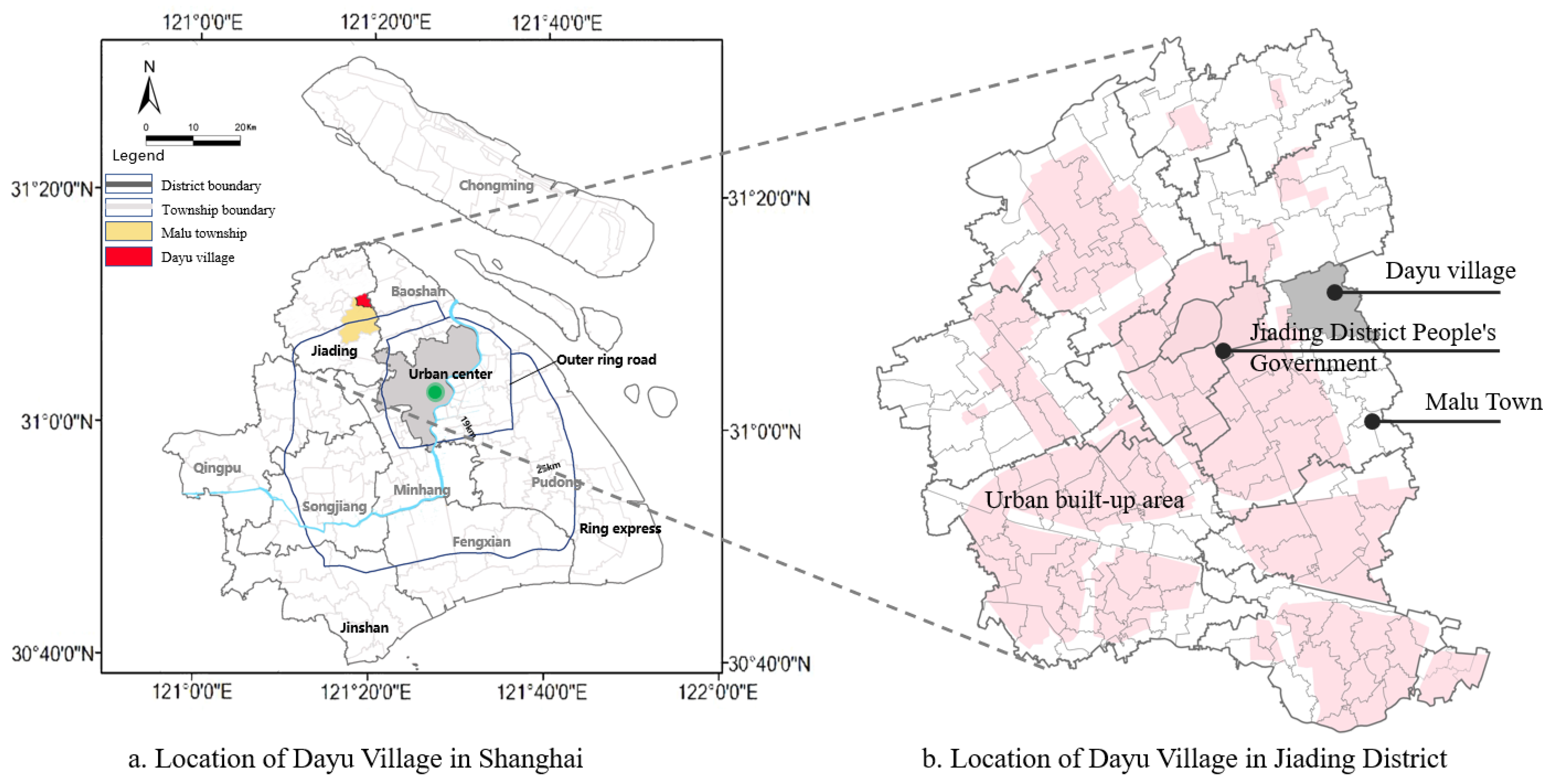
3.1. The Selection and Overview of the Study Area

Dayu Village is situated in the middle of Jiading District in Shanghai, on the east coast of China (Figure 1), and covers an area of 823 ha. The village’s primary feature is its focus on developing the cultural tourism industry, which is centered around characteristic grape planting. Dayu Village was selected as a research subject based on three considerations. First, driven by diverse land policies, Dayu Village has experienced significant changes compared to villages in Central and Western China. The spatial transition characteristics show considerable variations across stages. Before the 21st century, Dayu remained a traditional agricultural village and was subject to strict control under rural housing policies. After 2000, the implementation of village relocation policies led to the rapid agglomeration of rural settlements. In the 2010s, the land consolidation policy, along with the transfer of agricultural land and a reduction in industrial land, significantly changed the rural space. Secondly, Dayu Village is located in the suburban area of a megacity. Driven by rapid urbanization, the village’s social economy has significantly changed, distinguishing it from exurban villages in Shanghai. In terms of population, the registered population of Dayu Village in 2000 was 7772, and the migrant population was 2038. After a series of policies, the registered population of the village decreased to 2965 in 2020, while the migrant population increased to 5209. Consequently, this village serves as an excellent example of rural spatial transition characteristics at different stages of socioeconomic development in a megacity.

3.2. Data Collection

The official statistical data in China only reaches the township level, and there is a lack of statistical data at the administrative village level. In order to overcome this obstacle and to better understand the changes in land use, social space, and economic space in Dayu Village, we adopted the following comprehensive methods in this study. Among them, a participatory rural assessment was mainly used to assist in obtaining historically accurate rural land use data. Questionnaire surveys were mainly used to obtain data on rural social and economic space. In-depth interviews were used to obtain detailed information about the rural development process. The data obtained via the above methods are presented in the Results section.

3.2.1. Participatory Rural Appraisal

Utilizing historical Google Earth images from 2000, 2010, and 2020, we generated a comprehensive working map of the rural survey conducted in Dayu Village. Initially, we employed remote sensing images to digitize the polygons of each patch, enabling us to document the use states of rural settlements for each period and compile corresponding rural land use data over the 3 years. Subsequently, we utilized the participatory rural appraisal (PRA) method to conduct interviews with members of 50 households in the village and validate the land use data. The participants included village committee directors, cadres, and knowledgeable elders familiar with the village’s conditions. We complemented the findings with on-site surveys and verifications to obtain detailed processes, accurate data concerning land use changes, and specific information related to rural land, housing, industry, socioeconomic factors, and transitionary data. Finally, we utilized ArcGIS 10.5 software to generate maps illustrating rural land use at each stage and established a comprehensive database to correlate the data.

3.2.2. Questionnaires and Data Processing

To gather socioeconomic attribute information, we conducted a survey of 90 villagers (88 questionnaires were returned) and 90 migrants (86 questionnaires were returned) in June 2022, using a questionnaire. The questionnaire was distributed according to the principle of random sampling. It should be noted that since Dayu Village contains some natural villages, the number of questionnaires distributed to villagers was determined according to the proportion of the number of households in each natural village to the administrative village. Similarly, the number of questionnaires distributed to migrants was determined according to the proportion of the migrant population in each natural village to the administrative village.
The questionnaires focused on the following information: the basic characteristics of the households, including the number of rural households, the age of the population, and types of employment; the income and consumption of farmers, including the total household income, crop income, non-agricultural income, and consumption expenditure; and the utilization of homesteads, including the land area, building area, construction time and materials, number of floors, and internal structure. These data were mainly used in a subsequent analysis of the transition characteristics of social and economic spaces. ArcGIS 10.5 software was used to enter the survey information into a household-based database, thus establishing a rural land use transition database.

3.2.3. In-Depth Interviewing

In-depth interviewing is a unique qualitative research method in which an interviewer investigates interviewees’ answers by asking further detailed questions. We chose 14 interviewees based on the following criteria to obtain detailed information about the rural development process. First, the interviewees were willing to be interviewed and understood the history of rural development. Second, they had lived in the village for over ten years and had solid understanding of it. Third, they were somehow related to the different categories. The interviews lasted one hour on average. Table 1 provides a summary of the main characteristics of the interviewees.

3.3. Research Method

Fragstats software 3.2 was employed to calculate landscape metrics to explore detailed rural settlement transition characteristics (Table 2). Landscape metrics (LMs) were utilized to describe the scale, shape, and composition of patches, which consisted of contiguous areas of the same category. Given the aim of characterizing the morphology of rural settlement transition, we treated all rural settlement land as a single class. Some key class-level metrics from the literature survey were used to reflect transitions in the scale, distribution, compactness, and complexity of the rural settlement’s morphology [65]. The area characteristics are reflected by the mean patch size (MPS) and the standard deviation of the patch area (SD). The landscape shape index (LSI) and fractal dimension index (FRAC) reflect the shape characteristics. A low LSI value indicates compact individual patches. The patch density (PD) index and landscape division index (DI) reflect spatial agglomeration characteristics. A high PD value reflects decentralized trends, while a low value reflects centralized trends.

4. Results

4.1. Rural Development Stage

4.1.1. Strict Homestead Control Stage (before 2000)

Before 2000, Dayu Village primarily relied on traditional agriculture, including rice, vegetable, and grape cultivation. Restricted by the low farming level, as well as the layout of rivers and other physical factors, the rural settlements maintained a scattered spatial layout (Figure 2a). Each natural village functioned independently, with limited interactions between villages. The villagers were assigned houses within the natural villages based on kinship relationships, resulting in a spatial pattern in which villagers with the same surname resided in close proximity. During this period, under the strict homestead control policy, various construction activities were forbidden, and the spatial transition in the village was very slow. The following quotes from our interviewees illustrate the situation:
“Grape cultivation in our village began in 1981. The village had many rivers at that time, and the planting conditions were good. The villagers also set aside a piece of land to grow grapes when growing grain. At that time, there were few migrant workers, people with the same surname lived together, and the houses were adequate, so the village changed very slowly.”
(VC1)

4.1.2. Village Relocation Stage (2000–2010)

Since the 21st century, rapid urbanization has increased villagers’ demands to improve their living conditions. The village relocation policy was implemented in 2000 to solve the problem of scattered rural settlements. This policy involved relocating 220 households from the middle of the village to centralized rural settlements on the west side. Concurrently, the village committee capitalized on the opportunity to develop rural tourism as a result of rapid urbanization in Shanghai. In 2008, with the construction of the Malu Grape Theme Park, Dayu Village transformed into a scenic spot with multifunctional areas, offering leisure and entertainment, agritourism, and more. The thriving tourism industry also resulted in positive social and economic outcomes, providing employment opportunities to over 200 villagers via dining sales, parking management, environmental maintenance, and related positions. By 2010, the number of village tourists had reached 150,000, as reported by the Statistical Yearbook [66]. However, rural settlements on the north side of Taxin Road and the east side of Liushi Road continued to have a scattered layout (Figure 2b).

4.1.3. Land Consolidation Stage (2010–2020)

In response to the inefficient use of homestead and rural industrial land resulting from urbanization, the village committee implemented a land consolidation policy using three methods to optimize the spatial structure of the rural settlements (Figure 2c). Firstly, to accommodate the construction of a high-voltage corridor on the village’s west side, 69 households were resettled in the urban community of Malu town along the corridor. Secondly, 85 households residing in scattered rural settlements near Liuxiang Road and villagers who met the requirements for building new houses were consolidated in the Xiaoxu concentrated settlements. By the end of 2020, the two concentrated settlements occupied 9.8 ha and were equipped with roads, electricity, water, and other supporting infrastructure. This policy promoted a separation between rural production and living spaces, leading to an increasingly urbanized rural lifestyle. Thirdly, the village committee reclaimed expired industrial land and converted it into farmland. The saved construction land was utilized to develop a cultural tourism industry, capitalizing on the robust tourism market demand surrounding megacities and the abundant landscape resources. The village committee initiated the exploration of four-season tourism projects, including visitors’ centers and painters’ studios, to promote the upgrading of rural industries and increase economic income. This is evidenced in the following interviews.
“In 2010, we planned to add land for tourist facilities, but the Jiading District Planning Bureau told us that we can only add land for tourism construction after reclaiming the original industrial land.”
(VC2)

4.2. Characteristics of the Land Use Transition

4.2.1. The Spatial Differentiation of the Land

The land use layout of Dayu Village underwent multiple changes, transitioning from single, homogeneous land use to nested combinations and block structures (Figure 3). Rural settlements transformed from scattered to clustered layouts. During the strict homestead control stage, the village showed a single homogeneous layout mainly composed of agricultural land, a water area, and rural residential land. To align with the self-sufficient agricultural economy, the land use structures of rural homesteads and agricultural land primarily served the purpose of agricultural production.
During the village relocation stage, point-shaped spaces such as rural settlements, and business and tourist service lands were nested and combined within agricultural or industrial land. The area of rural settlements decreased, and the spatial layout became more concentrated. These concentrated rural settlements formed new residential districts to improve living conditions. The industrial land continuously encroached on the agricultural land. In other words, the industrial land area significantly increased while the proportion of agricultural land declined. Meanwhile, the agricultural land was divided into land for growing grain and land for economic crops. With the development of tourism, space for catering, parking lots, and tourist facilities increased, resulting in patchy growth in commercial, public service facility, and green land.
During the land-consolidation stage, driven by the development of cultural tourism, the spatial structure exhibited a block layout, and spatial disparity in land use types became evident. The further aggregation of rural settlements led to significant reductions in the number and area of rural settlement patches, with a layout characterized by a large concentration and small dispersion. Commercial and tourism service land continually replaced industrial land, forming different functional blocks and optimizing the structure of rural construction land. The diversification and utilization of land were further improved when family inns began to provide one-stop services, including catering, tourist accommodations, and entertainment. Consequently, Dayu Village transformed from a place primarily comprising residences and agricultural production to a multifunctional service center. This transition aligns with rapid rural urbanization due to land policy changes.

4.2.2. An Orderly Form of Spatial Layout

The spatial layouts of rural settlements are continually converging. The number of patches is decreasing, the average patch area is increasing, and the patches are changing from irregular shapes into more regular, square shapes. These changes in landscape metrics reflect the influence of multiple policies on the morphology of rural settlements (Table 3). Our findings differ from those in remote China, where out-migration led to hollowing and irregular patches in rural settlements [18].
Regarding area metrics, the MPS increased from 2.45 to 3.28 ha, which is a 33.9% increase. This is because the establishment of two concentrated settlements merged many smaller patches, increasing the MPS. The SD increased from 2.07 to 2.6, which is a 25.6% increase. This increase can be attributed to large concentrated and small trivial settlements which enlarged the scale difference among patches.
Regarding shape metrics, both the LSI and FRAC fell significantly, decreasing by 19.2% and 7.8%, respectively. This indicates that most rural settlements became more regular in shape. Rural settlements are built spontaneously without policy intervention, resulting in irregular shapes and boundaries. In contrast, some rural settlements merged due to the intervention of a series of policies. As a result, the number of patches decreased, and the shapes and boundaries of the patches tended to become more regular.
Regarding distribution metrics, the PD decreased from 2.91 to 2.18, which is a 25.1% decrease. This indicates that the number of patches decreased significantly, and the spatial distribution was more concentrated. The DI decreased from 0.99 to 0.91, which is an 8.1% decrease. This shows that the settlements became more aggregated due to policy influence, leading to a decrease in landscape segmentation.

4.2.3. The Diversity Transition of Village Houses

The village houses exhibit three distinct characteristics: the encroachment of housing into the courtyard, internal division and densification, and three-dimensional development (Figure 4). In the strict homestead control stage, the villagers built modest, one-to-two-floor brick–concrete homes due to economic constraints. The homesteads were often located in the center of cultivated areas due to the ease of farming, flat land, and ample water supply. The walls were constructed with blue bricks, the exteriors were painted with lime, and the roofs were constructed with blue tiles. The houses were mainly living spaces for storing farming tools. The majority of houses encompassed courtyards, main rooms, and auxiliary rooms. The internal layouts commonly followed a linear arrangement characterized by a compact design, with many kitchens and bathrooms located externally for storage reasons. This configuration aligns with a spatial arrangement focused on farming [49].
The village houses have gradually been subdivided due to relocation and land consolidation policies. In concentrated settlements, the houses present a neat and uniform layout. This spatial arrangement of houses no longer relies on familial ties, leading to the dissolution of clustered housing linked to shared family names. These homes offer better living conditions due to urban standards: proper ventilation, adequate lighting, and access to natural sunlight. However, this transformation has also contributed to the gradual fading of rural characteristics. The increase in economic development enables villagers to experience enhanced material and spiritual well-being. This, in turn, results in an immediate need to enhance their living environment and comfort once they have accumulated sufficient savings.
In scattered settlements on the periphery, the significant influx of tourists has given rise to diverse tourism-related enterprises, including family inns and hotels. Due to housing policies that restrict the expansion of homesteads, villagers have used three strategies to create more rentals and space: compressing courtyards, adding more building floors, and enhancing internal divisions (Figure 5). The original rural bungalow has been partially replaced by a two-to-three-story frame structure, resulting in vertical expansion. Building materials have improved, featuring more ceramic tiles on walls and decorative elements like pillars and glazed tiles. The structure of rural housing now closely resembles that of urban communities, featuring separate indoor kitchens and bathrooms. The residential function has been enhanced, while the original function of storing agricultural tools has faded. Houses now have more space, storage, and bedrooms, but courtyards are no longer built. Tourist accommodation and lodging intensified as empty rooms generate extra income through rentals or tourism-related activities.

4.3. The Transition Characteristics of Economic Space

4.3.1. Complex, Multifunctional Industrial Structure

The industrial structure of Dayu Village has transitioned from primarily agricultural to a combined, multifunctional agriculture–tourism complex. This transition is attributed to the village’s abundant agricultural and tourism-related resources and its strategic location in proximity to the metropolitan core. In the village relocation stage, the village committee relied on the advantages of location and rural scenery, and they developed the tourism industry based on grape planting. The natural landscape attracted numerous visitors to Dayu Village for recreational activities, creating a burgeoning industry that combines agriculture and tourism. However, due to the low number of agritourism services, the economic contribution is not high. Thus, the village committee also relied on leasing industrial plants to bolster the collective economic income.
In the land consolidation stage, the total amount of construction land was locked, and the Shanghai government has implemented a policy of increasing urban construction land by decreasing rural construction land since 2010 [64]. The village committee reclaimed old industrial sites and focused on eco-culture, tourism, and various industries. Ultimately, Dayu Village merged modern agriculture, unique product processing, agritourism, and cultural industries into a multifunctional industrial structure. The introduction of diverse industries enhanced the village’s endogenous development capacity. The village formed an economic structure with farming and local enterprises as the main sources of income, while administrative and public costs are major expenditures (Figure 6).
According to the Malu Statistical Yearbook, the benefits of grape planting consistently increased; prices increased from 3 RMB/catties in 2000 to 16 RMB/catties in 2020 [66]. Various cultural and tourism enterprises managed by the village collective around the theme of grapes have increased its economic income. The combined earnings of agriculture and village-run enterprises constituted 69.9% of the village’s average annual income. The following tourist comments show the transition of economic space.
“The quality of the grapes in Dayu Village is good. Although the price of grapes purchased in downtown Shanghai is lower, they are not fresh, and the taste is not good.”
(T1)
“I used to come in the summer and just buy the grapes. Nowadays, I sometimes take my children to participate in some outdoor parent-child activities or take relatives to visit the village.”
(T2)
Nonetheless, the village committee incurs many administrative costs due to the consistent shifting of social management costs from higher-level government to the village collective. Our field survey reveals that Dayu Village established an integrated management center encompassing eight functions: managing social governance, handling correspondence and visits, ensuring justice, coordinating logistics, maintaining security, overseeing policing, managing migrant populations, and providing livelihood services. At the same time, the center employs security personnel, population coordinators, and sanitation staff, increasing public expenditure. Due to the dispersed nature of settlements for immigrant populations and local villagers, the complexity and expenses of management escalated. Consequently, the village instituted both daytime and nighttime defense teams. The public and administrative expenditures account for 72.4% of the village’s total annual expenditure. This can be determined from the following interviews.
“Nowadays, there are many migrant workers, making social security more difficult. Therefore, we have established both daytime and nighttime defense teams, which increases the administrative expenditures.”
(VC2)

4.3.2. Diversification of Villagers’ Livelihoods

The villagers’ livelihoods have shifted from a reliance on agriculture to a diverse mix of non-agricultural options. In the strict homestead control stage, the villagers were constrained by nature and a low level of agricultural technology. They mainly relied on farming, with limited economic activity beyond agriculture. During the village relocation phase, the villagers’ livelihoods underwent notable diversification. Some villagers relocated to centralized settlements and sought employment opportunities in factories or urban regions, moving away from their previous agricultural activities. Some villagers used homesteads to carry out farmhouse entertainment or family farm activities. Some villagers became grain growers after undergoing training. According to our survey, some families comprised only elderly people and children staying with villagers for agricultural production, while others became migrant workers. During the land consolidation stage, the villagers engaged in diverse industries, developing various livelihoods like professional farming, tourism, self-employment, and house leasing. For example, some villagers provided the following statements in the interviews:
“I used to work in downtown Shanghai, where the salary was not high, and the rent was expensive. Now I’m back in the village, the house is spacious. I also run a farm business, which gives me some savings.”
(V3)
“There are two houses which were left to me by my grandfather. One house has six rooms for rent, and the monthly rent for two houses can be 7000 RMB.”
(V5)
“I work for a tourism company in the village, doing some tourism reception and service work. I also have a house for rent. In total, I can get 8400 RMB a month.”
(V4)
The primary sources of household income shifted from farming to self-employment and house rentals. Daily expenses and children’s education have become the main types of household expenditure (Figure 7). Our field investigation showed that the villagers’ average annual household income totaled RMB 134,200. Income from self-employment constituted 28.7%, while house rentals represented 25.5%. On average, every household leased out four to six rooms priced at RMB 620 per room per month. This observation indicates that home rentals have emerged as a significant contributor to the villagers’ household incomes. This trend is driven by migrant workers, particularly those from urban areas, flowing into rural areas, leading to an increased demand for rental accommodations.
The villagers’ livelihoods underwent significant changes owing to land policy reforms and enhanced productivity. Our research shows that village families spend RMB 79,000 annually on average. Significantly, 32.5% is spent to daily expenses and 29.2% is spent on children’s education. This aligns with the trend that prosperous rural areas spend less on daily life. Many villagers use their homes as rentals or for tourism, with 6.2% of the expenses allocated for housing repairs. Tourism costs amounted to 5.6%, indicating increased household consumption due to improved living standards. Therefore, village families have extra funds after deducting various expenses. This motivates them to participate in future rural development by buying collective village shares or joining relevant labor sectors. As some villagers stated,
“If the village needs labor to develop industry, I am willing to participate in it.”
(V2)
“I am willing to spend part of my money to invest in the village collective to support the further development of tourism.”
(V1)

4.4. Transition Characteristics of Social Space

4.4.1. Demographic Alienation

The villagers’ migration patterns have shifted from static stability to dynamic population outflows and inflows. During the strict control stage, the villagers were limited to agricultural work within the village and lacked mobility, resulting in a relatively stable population structure. During the relocation stage, rapid external industrialization and urbanization led to the seasonal emigration of villagers for non-agricultural employment. Only elderly villagers with a nostalgic attachment to rural life stayed in the village, aggravating the aging population problem. During the consolidation stage, the cultural tourism industry created additional job opportunities. Considering living expenses and family relationships, villagers returned to their homesteads for work, mitigating the aging issue. Also, Dayu Village drew many migrant workers from central and western provinces because there were many job opportunities. The number of migrant workers in Dayu Village increased by 24%, contrasting with the severe depopulation occurring in western rural China [67].
For houses with the same building area, the rent in Dayu Village is only half of the rent in Malu Town. The low rent attracts a large influx of migrant workers with two to three family members, which gradually shifts the population structure. Some migrant workers said the following:
“I come from Jiangsu Province and work in Malu industrial zone. I live here because the house rent is cheap.”
(M2)
“My hometown is Anhui Province, and I’m an online ride-hailing driver. The housing in the village is cheap, the parking lot and charging stations are also available. So I decide to live here.”
(M3)
Frequently, villagers turn to the unauthorized construction or partitioning of rooms to increase the supply of rental housing. Each village house accommodates four to six families, creating the phenomenon of group rentals in the countryside, which is significantly different from urban group rentals. The survey results revealed that in 2020, Dayu Village hosted a migrant population of 5209 in stark contrast to its registered population of 2965. The considerable influx of migrants generated pronounced deficits in various infrastructure resources, which were initially apportioned based on the registered population. This imbalance has led to problems with accessing water and electricity during peak consumption periods.

4.4.2. The Defamiliarization of Social Relations

Various policies greatly affected the villagers’ social networks, resulting in a shift from villagers being acquaintances to semi-familiar and even strangers. In the strict control stage, the villagers’ interactions were restricted by their reliance on agriculture, which limited their social relations to acquaintances in the natural village. Communication primarily revolved around basic administrative connections among natural villages. During the relocation stage, the original rural acquaintance society began to disintegrate. As people migrated from natural villages to centralized settlements, the villagers experienced major shifts in their living patterns and environment, and they became less familiar due to varying living habits. Also, tourists entering the village resulted in increased business interactions, thus forming a semi-familiar society in Dayu Village.
During the land consolidation stage, social relations grew more unfamiliar (Figure 8). The increased societal division of labor led to greater professional diversity among the villagers, encompassing concurrent enterprises, self-employment, local labor, and substantial grain production. This change introduced a relatively intricate shift in the villagers’ social networks. Business ties and economic interests gradually replaced previous relationships based on familial and geographical ties. Therefore, mutual assistance and emotional exchanges gradually shifted to economic reciprocity. The interviews showed that about 75% of participants experienced a decline in interactions with their previous friends and neighbors (Figure 8).
The influx of migrant workers changed the homogeneous group structure, and the villagers’ awareness of self-protection increased. Migrants and villagers only interact through house leasing and not as equals in the neighborhood. Different habits and language barriers hinder in-depth communication. According to our interviews, migrant workers mainly come from provinces near the Yangtze River Delta. Their educational level is relatively low, generally at the middle school level, which is also a common feature of migrant workers in megacities [64]. They work in labor-intensive industries, earning about RMB 5500 monthly. Their residual disposable income is limited after taking deductions for living expenses and supporting their dependents. Hence, most of them cannot afford to rent city apartments, so they rent rural houses. They obtain employment information through networks of acquaintances in their hometowns, and they mainly perform manual labor in factories. The closed environments of factories lead migrants to rent village houses from families, but communication is limited to the topics of rent and daily expenses, with few other chances to communicate. This is clearly shown in the migrant workers’ interviews.
“I come here with my wife, and our children are in high school in my hometown.”
(M1)
“I only met the landlord when I signed the rental contract. I usually transfer money through WeChat.”
(M4)
“All the tenants share the kitchen, but the tableware is separated. I usually contact acquaintances in my hometown, and seldom with contact other co-tenants.”
(M5)

5. Discussion of Policy Mechanisms

Natural resources, social and economic development, and policies have driven changes in the villagers’ needs. The villagers’ behavioral responses promote the flow of the three elements of rural land, population, and industry, thereby promoting the multidimensional transition of rural space (Figure 9). Among these factors, natural resources have shaped the fundamental rural spatial layout. The water system in Dayu Village has a crisscross pattern, and rural settlements are laid out at the river’s intersection, forming clusters. Constrained by production resources and farming levels, the various needs of the villagers are resolved within the natural village. Social and economic development induces shifts in the needs of the villagers. Economic development has increased their income level, providing an economic basis for house renovations and stimulating a demand for improved living conditions. The level of agricultural mechanization has improved production efficiency, enabling the villagers to overcome the spatial constraints of agricultural land and stimulating diverse employment methods. The improved traffic conditions have stimulated the villagers’ need for wider social interactions.

5.1. Policies Regulate the Needs of Villagers and Trigger Spatial Changes

Various policies shape the villagers’ needs and modulate their behavioral responses, effectively integrate land and labor elements, recombine the industrial and job structure, and optimize rural functions. The socioeconomic forms and spatial structure of Dayu Village are undergoing rapid restructuring. Rural settlements were originally planned for small-scale peasant economies, emphasizing practical living and agricultural production. However, in later stages, policy regulation included multifunctional and comfort aspects of village houses due to increased incomes. Therefore, we argue that land use policies largely contribute to the transition of rural settlements in these megacities [25].
In the initial stages, policies regulated the villagers’ behaviors, influenced land allocation, and promoted the spatial agglomeration of rural settlements. This led to fewer rural settlement patches, a larger average patch area, and a more regular shape and orderly form of the spatial layout; in addition, the houses also become more diversified. Later, the flow of land elements triggered the transition and upgrading of industrial elements. Traditional agricultural space was divided into modern agriculture and characteristic agriculture. Inefficient industrial zones were repurposed for cultural and creative industries, forming a mix of primary and tertiary sectors.
Rural settlements evolved from a single residential function to a collection of multiple integrated functions, including the villagers’ lifestyles, tourism services, and housing rentals. Consequently, the villagers’ livelihoods shifted from agricultural production to non-agricultural employment. Finally, the flow of land elements accelerated the flow of the population. Along with the outflow of villagers and the inflow of migrants, significant changes occurred in the rural population structure, resulting in shifts in the extent and content of the villagers’ interactions. Dayu Village transitioned from a conventional enclosed community of familiar individuals to an inclusive and varied society of strangers [8]. For migrant workers, residential migration drove the need for housing. This is different from rural gentrification in the Global North, where the urban middle class migrated to the countryside in search of living and leisure space, encroaching on the living space of villagers and causing changes in the social structure of the countryside [42,68].

5.2. Gradual Policy Improvement Forms External Power

The regulatory scope of various policies has expanded from a single rural settlement to the whole domain of the village (Figure 10). In the strict control stage, strict housing control policies constrained the villagers’ demand for housing construction. In the relocation stage, policy control was limited to rural settlements, resulting in a poor overall effect of the spatial transition. Firstly, policies lacked measures regarding the agglomeration of agricultural land; thus they restricted the spatial agglomeration of rural settlements. Secondly, the expansion of industrial areas drew in migrant workers, while the demand for new rental housing encouraged the unauthorized construction of houses, thereby exacerbating rural spatial fragmentation. In the land consolidation stage, the scope of policy regulation was expanded to the whole rural space, with increased regulation concerning reducing industrial land and transferring agricultural land. The land consolidation policy effectively turned abandoned settlements into cultivable land. The industrial land reduction policy reduced low-skilled employment and curbed the undue influx of migrants, consequently lessening the need for rental housing and curtailing the unlawful construction of village houses. Meanwhile, the agricultural land transfer policy conformed to the trend of agricultural modernization. It helped to promote the transition of agricultural space from fragmented to agglomerated, thereby promoting the concentration of rural settlements.
In this process, the spatial agglomeration of rural settlements was promoted through the combination of constraints and guidance. On the one hand, constraints were applied to continuously refine housing control policies and effectively restrict the villagers’ housing construction behavior. These policies can anchor the spatial boundaries of rural settlements and refine the homestead application procedure, building standards, and control rules. Thus, they can help avoid scattered space and optimize the shape of rural settlements. On the other hand, guidance was applied to meet the various requirements of the villagers. These policies helped improve the allocation of public facilities and guided the villagers to build houses in concentrated settlements.
Guided by policies, Dayu Village’s rural settlements have been improved, but some shortcomings remain. Firstly, the content of the policies lacks a refined regulation of concentrated rural settlements and rural public spaces. Village houses within the concentrated settlements are arranged linearly, leading to the disappearance of rural features. Traditional public spaces such as ancestral halls, bazaars, and theaters have entirely vanished, resulting in the absence of essential venues for weddings, funerals, banquets, and festivals, which is not conducive to continuing traditional rural culture and folk customs. Secondly, policy formulation is not aligned with the diverse needs of the villagers. The willingness to reside in a village varies with age, employment, and consumption patterns. Policy formulation should transition from village-wide to household-specific, with pertinent content individualized based on villagers’ requirements. Villagers who want to leave can realize their land rights and leave the village smoothly; villagers who want to stay for agricultural production can gradually expand their farming area; villagers who want to stay in the village for non-agricultural employment can obtain more employment opportunities; and villagers who want to stay in the village for the elderly can provide them with better living conditions, reduce the cost of living, and improve their quality of life. Lastly, as migrant workers return to their western hometowns, rural settlements in Chinese megacities might face the significant challenge of being hollowed out, and relevant coping policies may need to be developed [64].

5.3. Differentiated Behavioral Responses Form Internal Dynamics

Villagers are the actors in rural spatial transition, and their differentiated behavioral responses form internal dynamics (Figure 11). Social and economic developments induce changes in villagers’ needs, and their rational adjustment behavior promotes rural settlement transition. After weighing the pros and cons of policies, villagers will make choices to maximize their interests. Their behavior will shift from homogeneous groups to heterogeneous individuals. In the strict control stage, the villagers were passive policy executors. Strict housing control policies and backward production conditions bound the villagers within each natural village; thus, scattered rural settlements are surrounded by agricultural land. Rural industries were dominated by agriculture, and the villagers’ production, housing, and communication needs showed homogeneous characteristics, forming an acquaintance society based on blood relationships.
In the village relocation stage, social and economic development stimulated the villagers’ demand for comfortable living and travel convenience because the poor environment and old houses of the past could not satisfy their needs. Guided by policies, the villagers migrated to centralized settlements and became active participants in policy. To pursue economic gains, the villagers shifted from grain fields to economic crops, leading to a divergence of agricultural land. Tourism stimulated the demand for rental houses. Constrained by strict homestead control policies, the villagers adopted methods such as increasing the number of floors in building and subdividing rooms to increase rental area. The development of rural tourism alongside the expansion of industrial land promoted the structural transition of rural areas to a combination of agriculture and tourism. The villagers’ livelihoods began to diverge. After tourists appeared, the villagers’ awareness of the need to protect themselves increased, and the village gradually turned into a semi-stranger society.
In the land consolidation stage, the villagers had higher demands for quality of life and become policy coordinators and optimizers. Under the consolidation policy, the villagers further migrated to the concentrated settlement on the north side of the village. Concurrently, the village committee actively participated in industrial land reduction and transition, and they promoted the development of the original scattered farmhouses into a cultural tourism industry with a centralized layout. Meanwhile, economic development provided diverse non-agricultural employment opportunities, and villagers gradually returned to their homesteads for work. Due to differences in employability and needs during this process, the villagers had diversified livelihoods such as grain farming, homestay accommodations, and tourism services. The influx of migrants and tourists affected the tranquility of the countryside. The change in the scope and subject of the villagers’ communication transformed the village from a society of close ties based on kinship to loose ties based on economic interests, and the village gradually turned into a society of strangers. In general, a chain of displacement was formed, with villagers moving from scattered settlements to concentrated settlements and migrant workers moving from towns to scattered settlements. Rural chain displacement moved in the opposite direction compared with the Global North [69].

5.4. Policy Recommendations

In order to effectively promote more suitable rural space for the diverse needs of villagers, policies can be optimized from three aspects. Firstly, policy formulation should transition from village-wide to household-specific, enhancing pertinent content based on individual requirements. In fact, villagers’ willingness to reside in a village varies based on age, employment, and consumption patterns. Villagers who want to leave can realize their land rights and leave the village smoothly; villagers who want to stay for agricultural production can gradually expand their farming area; villagers who want to stay in the village for non-agricultural employment can obtain more employment opportunities; and villagers who want to stay in the village for the elderly can provide them with better living conditions, reduce the cost of living, and improve the quality of life.
Secondly, more refined regulations centered on concentrated rural settlements and rural public spaces should be added to the policy formulation. On one hand, the village houses within a concentrated settlement should be better situated to avoid a linear arrangement and the disappearance of rural features. On the other hand, traditional public spaces such as ancestral halls, bazaars, and theaters should be kept for weddings, funerals, banquets, and festivals, which is conducive to continuing traditional rural culture and folk customs.
Lastly, as migrant workers return to their western hometowns, rural settlements in Chinese megacities might face the significant challenges of being hollowed out, and more diversified measures for the reuse of idle village houses should be considered in policies (Figure 12). Idle village houses with convenient transportation and good construction foundations should be transformed into public facilities. Idle village houses located at the edges of rural settlements can be directly reclaimed as agricultural land. Scattered idle village houses can be changed into shared orchards or vegetable fields. Idle village houses in better locations can be vacated to meet the needs of other villagers to build new houses.

6. Conclusions

6.1. Main Findings

Due to multiple land policy factors, there is enormous spatial differentiation in the transition of rural settlements in the megacities of developing countries, which are different from other countries and areas. Determining transition characteristics and policy mechanisms can aid in developing more effective optimization measures. Using a participatory rural appraisal, a landscape metrics analysis, and questionnaires, this study constructed a research framework to measure the transition characteristics and reveal the policy mechanism of Dayu Village during different policy periods. The primary findings are outlined as follows.
First, Dayu Village has experienced three development stages under the influence of diversified policies. In 1990–2000, the village was in a strict homestead control stage, various construction activities were forbidden, and the spatial transition in the village was very slow. In 2000–2010, the village was in a relocation stage, and 220 scattered households were relocated to centralized rural settlements on the village’s west side. In 2010–2020, the village was in a land consolidation stage, and three measures were used to optimize the spatial structure of the rural settlements.
Second, the village realized a multidimensional spatial transition. Regarding land use, it transitioned from single, homogeneous land use to nested combination and block layouts. Rural settlements were reduced significantly, with more regular patch shapes and an agglomerated layout. The village houses underwent three transition characteristics: encroachment into the courtyard, internal subdivisions, and three-dimensional development. Regarding the economy, the industrial structure transitioned from agriculture-dominant to an integration of agriculture and tourism with multifunctional compounding. The villagers’ livelihoods changed from agricultural to diverse non-agricultural employment. Regarding society, the migration of villagers has experienced stability as well as population outflow and inflow. The influx of tourists and migrant workers changed the rural population structure, pushing the village society from acquaintances to semi-strangers and strangers.
Third, policies promoted the transition of rural settlements by allocating land resources and regulating the villagers’ behavior. Social and economic development stimulated changes in the villagers’ needs. Different policies regulated the villagers’ needs, thus triggering a multidimensional transition of rural land, industry, and population. The scope of policy governance expanded from single settlement to the whole domain of the village, optimizing external force. The policy of combining constraints and guidance accelerated the spatial transition, with the villagers’ differentiated responses to various policies constituting the internal driving force of the rural settlement’s transition. Effectively matching top-down policy formulation and bottom-up villagers’ needs is the key to promoting the optimization of rural space.
The findings of this study dynamically reveal the transition characteristics and mechanism underlying different policies in Dayu Village over the past three decades rather than merely a short period. They enrich the research content by providing an empirical analysis of a typical suburban village of a metropolis in a developing country, and they reveal the detailed characteristics of the transition at the microscopic village scale. In addition, the unified framework of land–society–economy can provide scientific guidance for an in-depth understanding of rural settlement transition.

6.2. Limitations and Future Research

There are still some limitations that need to be addressed in future research. First, the temporal sampling in this research was minimal, with only three years (2000, 2010, and 2020), and nonlinear variability within the intervening periods was ignored. Future research needs to add more temporal sampling data to help reveal the transition process in more detail. Furthermore, this study employed a qualitative approach to analyze policy factors and mechanisms, but it could not precisely quantify the extent of the influence exerted by these policy factors on transition characteristics. Thus, a quantitative analysis of policy factors is required in future research. Finally, affected by various types of policies, the transition of rural space presents significant regional differences. Future research should select more typical cases to deepen the understanding of transition characteristics and policy mechanisms.

Author Contributions

Conceptualization, K.L. (Kaiming Li), K.L. (Kaishun Li), L.Y. and Y.L.; methodology, K.L. (Kaishun Li), K.L. (Kaiming Li), X.J. and Y.L.; investigation, K.L. (Kaishun Li), K.L. (Kaiming Li) and Y.L.; resources, K.L. (Kaishun Li); data curation, Y.L., X.J. and L.Y.; writing—original draft preparation, K.L. (Kaiming Li), L.Y. and Y.L.; writing—review and editing, K.L. (Kaishun Li); funding acquisition, K.L. (Kaiming Li) and L.Y. All authors have read and agreed to the published version of the manuscript.

Funding

This research has been sponsored by the Shanghai Pujiang Program (22PJC049), the Shanghai Planning Project of Philosophy and Social Science (2023BCK003), the Key Laboratory of Ecology and Energy Saving Study of Dense Habitat, Ministry of Education of China (20220101), the Ministry of Education of Humanities and Social Science Project of China (23YJCZH287), and the China Postdoctoral Science Foundation (2023M732174).

Data Availability Statement

Not applicable.

Acknowledgments

The authors gratefully acknowledge the funding support received.

Conflicts of Interest

The authors declare no conflict of interest.

References

  1. Gavari-Starkie, E.; Espinosa-Gutiérrez, P.-T.; Lucini-Baquero, C. Sustainability through STEM and STEAM Education Creating Links with the Land for the Improvement of the Rural World. Land 2022, 11, 1869. [Google Scholar] [CrossRef]
  2. Thissen, F.; Loopmans, M.; Strijker, D.; Haartsen, T. Guest editorial: Changing villages; what about people? J. Rural Stud. 2021, 87, 423–430. [Google Scholar] [CrossRef]
  3. Yang, F.; Sun, J.; Yang, J.; Liang, X. Expanded Residential Lands and Reduced Populations in China, 2000–2020: Patch-Scale Observations of Rural Settlements. Land 2023, 12, 1368. [Google Scholar] [CrossRef]
  4. Tian, J.; Zeng, S.; Zeng, J.; Wang, S. How Urban Expansion Triggers Spatio-Temporal Differentiation of Systemic Risk in Suburban Rural Areas: A Case Study of Tianjin, China. Land 2022, 11, 1877. [Google Scholar] [CrossRef]
  5. Carolan, M. Rural Sociology Revival: Engagements, Enactments and Affectments for Uncertain Times. Sociol. Rural. 2019, 60, 284–302. [Google Scholar] [CrossRef]
  6. Yang, Y.; Bao, W.; Wang, Y.; Liu, Y. Measurement of urban-rural integration level and its spatial differentiation in China in the new century. Habitat Int. 2021, 117, 102420. [Google Scholar] [CrossRef]
  7. Chai, Y.; Qiao, W.; Hu, Y.; He, T.; Jia, K.; Feng, T.; Wang, Y. Land-Use Transition of Tourist Villages in the Metropolitan Suburbs and Its Driving Forces: A Case Study of She Village in Nanjing City, China. Land 2021, 10, 168. [Google Scholar] [CrossRef]
  8. Li, K.; Geng, H.; Yue, L.; Li, K.; Huang, L. Spatial Differentiation Characteristics and Driving Mechanism of Rural Settlements Transformation in the Metropolis: A Case Study of Pudong District, Shanghai. Front. Environ. Sci. 2021, 9, 755207. [Google Scholar] [CrossRef]
  9. Hibbard, M.; Lurie, S. If Your Rural Community Is Failing, Just Leave? The Revival of Place Prosperity in Rural Development Planning. J. Plan. Educ. Res. 2019, 0739456X19895319. [Google Scholar] [CrossRef]
  10. Nilsson, K.; Nielsen, T.S.; Aalbers, C.; Bell, S.; Boitier, B.; Chery, J.P.; Fertner, C.; Groschowski, M.; Haase, D.; Loibl, W. Strategies for sustainable urban development and urban-rural linkages. Eur. J. Spat. Dev. 2014, 2014, 1–26. [Google Scholar]
  11. Wang, M.; Yang, Y.; Guo, T. Measurement of Urban–Rural Integration Level in Suburbs and Exurbs of Big Cities Based on Land-Use Change in Inland China: Chengdu. Land 2021, 10, 474. [Google Scholar] [CrossRef]
  12. Barrett, B.F. Environmentalism in periods of rapid societal transformation: The legacy of the Industrial Revolution in the United Kingdom and the Meiji Restoration in Japan. Sustain. Dev. 1999, 7, 178–190. [Google Scholar] [CrossRef]
  13. Kwon, H.-J. Implications of Korea’s Saemaul Undong for international development policy: A structural perspective. Korean J. Policy Stud. 2010, 25, 87–100. [Google Scholar]
  14. Kohler, F.; Marchand, G.; Negrão, M. Local history and landscape dynamics: A comparative study in rural Brazil and rural France. Land Use Policy 2015, 43, 149–160. [Google Scholar] [CrossRef]
  15. Jia, K.; Qiao, W.; Chai, Y.; Feng, T.; Wang, Y.; Ge, D. Spatial distribution characteristics of rural settlements under diversified rural production functions: A case of Taizhou, China. Habitat Int. 2020, 102, 102201. [Google Scholar] [CrossRef]
  16. Zhou, Y.; Li, Y.; Xu, C. Land consolidation and rural revitalization in China: Mechanisms and paths. Land Use Policy 2020, 91, 104379. [Google Scholar] [CrossRef]
  17. Qu, Y.; Jiang, G.; Tian, Y.; Shang, R.; Wei, S.; Li, Y. Urban-Rural construction land Transition(URCLT) in Shandong Province of China: Features measurement and mechanism exploration. Habitat Int. 2019, 86, 101–115. [Google Scholar] [CrossRef]
  18. Long, H.; Li, Y.; Liu, Y.; Woods, M.; Zou, J. Accelerated restructuring in rural China fueled by ‘increasing vs. decreasing balance’ land-use policy for dealing with hollowed villages. Land Use Policy 2012, 29, 11–22. [Google Scholar] [CrossRef]
  19. Salvia, R.; Halbac-Cotoara-Zamfir, R.; Cividino, S.; Salvati, L.; Quaranta, G. From Rural Spaces to Peri-Urban Districts: Metropolitan Growth, Sparse Settlements and Demographic Dynamics in a Mediterranean Region. Land 2020, 9, 200. [Google Scholar] [CrossRef]
  20. Liu, H.; Weng, D.; Liu, H. Decoding Rural Space Reconstruction Using an Actor-Network Methodological Approach: A Case Study from the Yangtze River Delta, China. Land 2021, 10, 1110. [Google Scholar] [CrossRef]
  21. Ma, W.; Jiang, G.; Li, W.; Zhou, T.; Zhang, R. Multifunctionality assessment of the land use system in rural residential areas: Confronting land use supply with rural sustainability demand. J. Env. Manag. 2019, 231, 73–85. [Google Scholar] [CrossRef]
  22. Song, W.; Li, H. Spatial pattern evolution of rural settlements from 1961 to 2030 in Tongzhou District, China. Land Use Policy 2020, 99, 105044. [Google Scholar] [CrossRef]
  23. Chen, M.; Zhou, Y.; Huang, X.; Ye, C. The Integration of New-Type Urbanization and Rural Revitalization Strategies in China: Origin, Reality and Future Trends. Land 2021, 10, 207. [Google Scholar] [CrossRef]
  24. Matsa, M.; Mupepi, O.; Musasa, T. Spatio-temporal analysis of urban area expansion in Zimbabwe between 1990 and 2020: The case of Gweru city. Environ. Chall. 2021, 4, 100141. [Google Scholar] [CrossRef]
  25. Zhu, F.; Zhang, F.; Ke, X. Rural industrial restructuring in China’s metropolitan suburbs: Evidence from the land use transition of rural enterprises in suburban Beijing. Land Use Policy 2018, 74, 121–129. [Google Scholar] [CrossRef]
  26. Egidi, G.; Halbac-Cotoara-Zamfir, R.; Cividino, S.; Quaranta, G.; Salvati, L.; Colantoni, A. Rural in Town: Traditional Agriculture, Population Trends, and Long-Term Urban Expansion in Metropolitan Rome. Land 2020, 9, 53. [Google Scholar] [CrossRef]
  27. Ruiz Pulpón, Á.R.; Cañizares Ruiz, M.d.C. Enhancing the Territorial Heritage of Declining Rural Areas in Spain: Towards Integrating Top-Down and Bottom-Up Approaches. Land 2020, 9, 216. [Google Scholar] [CrossRef]
  28. Foelske, L.; van Riper, C.J.; Stewart, W.; Ando, A.; Gobster, P.; Hunt, L. Assessing preferences for growth on the rural-urban fringe using a stated choice analysis. Landsc. Urban Plan. 2019, 189, 396–407. [Google Scholar] [CrossRef]
  29. Yang, R.; Loopmans, M. Land dispossession, rural gentrification and displacement: Blurring the rural-urban boundary in Chengdu, China. J. Rural Stud. 2023, 97, 22–33. [Google Scholar] [CrossRef]
  30. Wang, Y.; Zhu, Z.; Wang, Z.; Xu, Q.; Zhou, C. Household Registration, Land Property Rights, and Differences in Migrants’ Settlement Intentions—A Regression Analysis in the Pearl River Delta. Land 2021, 11, 216. [Google Scholar] [CrossRef]
  31. Tian, Y.; Qian, J.; Wang, L. Village classification in metropolitan suburbs from the perspective of urban-rural integration and improvement strategies: A case study of Wuhan, central China. Land Use Policy 2021, 111, 105748. [Google Scholar] [CrossRef]
  32. Zhu, J.; Pawson, H.; Han, H.; Li, B. How can spatial planning influence housing market dynamics in a pro-growth planning regime? A case study of Shanghai. Land Use Policy 2022, 116, 106066. [Google Scholar] [CrossRef]
  33. Palmisano, G.O.; Govindan, K.; Boggia, A.; Loisi, R.V.; De Boni, A.; Roma, R. Local Action Groups and Rural Sustainable Development. A spatial multiple criteria approach for efficient territorial planning. Land Use Policy 2016, 59, 12–26. [Google Scholar] [CrossRef]
  34. Conrad, C.; Rudloff, M.; Abdullaev, I.; Thiel, M.; Löw, F.; Lamers, J.P.A. Measuring rural settlement expansion in Uzbekistan using remote sensing to support spatial planning. Appl. Geogr. 2015, 62, 29–43. [Google Scholar] [CrossRef]
  35. McCarthy, J. Rural geography: Globalizing the countryside. Prog. Hum. Geogr. 2008, 32, 129–137. [Google Scholar] [CrossRef]
  36. Christaller, W. Die zentralen Orte in Suddeutschland: Eine okonomisch-geographische Untersuchung uber die Gesetzmassigkeit der Verbreitung und Entwicklung der Siedlungen mit stadtischen Funktionen. Jena 1933. [Google Scholar]
  37. Pacione, M. Rural Geography; Harper and Row: Manhattan, NY, USA, 1984. [Google Scholar]
  38. Higgs, G.; White, S.D. Changes in service provision in rural areas. Part 1: The use of GIS in analysing accessibility to services in rural deprivation research. J. Rural Stud. 1997, 13, 441–450. [Google Scholar] [CrossRef]
  39. Cloke, P.J. New emphases for applied rural geography. Prog. Hum. Geogr. 1980, 4, 181–217. [Google Scholar] [CrossRef]
  40. Li, G.; Jiang, G.; Jiang, C.; Bai, J. Differentiation of spatial morphology of rural settlements from an ethnic cultural perspective on the Northeast Tibetan Plateau, China. Habitat Int. 2018, 79, 1–9. [Google Scholar] [CrossRef]
  41. Liu, J.; Liu, Y.; Yan, M. Spatial and temporal change in urban-rural land use transformation at village scale—A case study of Xuanhua district, North China. J. Rural Stud. 2016, 47, 425–434. [Google Scholar] [CrossRef]
  42. Woods, M. Rural recovery or rural spatial justice? Responding to multiple crises for the British countryside. Geogr. J. 2023. [Google Scholar] [CrossRef]
  43. Phillips, M.; Smith, D.; Brooking, H.; Duer, M. The gentrification of a post-industrial English rural village: Querying urban planetary perspectives. J. Rural Stud. 2022, 91, 108–125. [Google Scholar] [CrossRef]
  44. Fromentin, J. A spatio-temporal approach to population diversity: Immigration and rural areas in France. J. Rural. Stud. 2023, 103, 103099. [Google Scholar] [CrossRef]
  45. Paniagua, A. Sustainable Geographical Changes in Rural Areas: Key Paths, Orientations and Limits. Sustainability 2021, 13, 2059. [Google Scholar] [CrossRef]
  46. Pereira, A.S.A.d.P.; dos Santos, V.J.; Alves, S.d.C.; Amaral e Silva, A.; da Silva, C.G.; Calijuri, M.L. Contribution of rural settlements to the deforestation dynamics in the Legal Amazon. Land Use Policy 2022, 115, 106039. [Google Scholar] [CrossRef]
  47. Li, T.; Long, H.; Liu, Y.; Tu, S. Multi-scale analysis of rural housing land transition under China’s rapid urbanization: The case of Bohai Rim. Habitat Int. 2015, 48, 227–238. [Google Scholar] [CrossRef]
  48. Li, H.; Song, W. Expansion of Rural Settlements on High-Quality Arable Land in Tongzhou District in Beijing, China. Sustainability 2019, 11, 5153. [Google Scholar] [CrossRef]
  49. Jiang, W.; Deng, Y.; Tang, Z.; Cao, R.; Chen, Z.; Jia, K. Adaptive capacity of mountainous rural communities under restructuring to geological disasters: The case of Yunnan Province. J. Rural Stud. 2016, 47, 622–629. [Google Scholar] [CrossRef]
  50. Wang, C.; Liu, Y.; Kong, X.; Li, J. Spatiotemporal Decoupling between Population and Construction Land in Urban and Rural Hubei Province. Sustainability 2017, 9, 1258. [Google Scholar] [CrossRef]
  51. Li, H.; Yuan, Y.; Zhang, X.; Li, Z.; Wang, Y.; Hu, X. Evolution and transformation mechanism of the spatial structure of rural settlements from the perspective of long-term economic and social change: A case study of the Sunan region, China. J. Rural Stud. 2022, 93, 234–243. [Google Scholar] [CrossRef]
  52. Qu, Y.; Jiang, G.; Yang, Y.; Zheng, Q.; Li, Y.; Ma, W. Multi-scale analysis on spatial morphology differentiation and formation mechanism of rural residential land: A case study in Shandong Province, China. Habitat Int. 2018, 71, 135–146. [Google Scholar] [CrossRef]
  53. Tu, S.; Long, H.; Zhang, Y.; Ge, D.; Qu, Y. Rural restructuring at village level under rapid urbanization in metropolitan suburbs of China and its implications for innovations in land use policy. Habitat Int. 2018, 77, 143–152. [Google Scholar] [CrossRef]
  54. Zhang, R.; Jiang, G.; Zhang, Q. Does urbanization always lead to rural hollowing? Assessing the spatio-temporal variations in this relationship at the county level in China 2000–2015. J. Clean. Prod. 2019, 220, 9–22. [Google Scholar] [CrossRef]
  55. Ma, W.; Jiang, G.; Wang, D.; Li, W.; Guo, H.; Zheng, Q. Rural settlements transition (RST) in a suburban area of metropolis: Internal structure perspectives. Sci. Total Environ. 2018, 615, 672–680. [Google Scholar] [CrossRef]
  56. Zhou, T.; Jiang, G.; Zhang, R.; Zheng, Q.; Ma, W.; Zhao, Q.; Li, Y. Addressing the rural in situ urbanization (RISU) in the Beijing–Tianjin–Hebei region: Spatio-temporal pattern and driving mechanism. Cities 2018, 75, 59–71. [Google Scholar] [CrossRef]
  57. Tian, C.; Fang, L. The Impossible in China’s Homestead Management: Free Access, Marketization and Settlement Containment. Sustainability 2018, 10, 798. [Google Scholar] [CrossRef]
  58. Liu, W.; Radmehr, R.; Zhang, S.; Rastegari Henneberry, S.; Wei, C. Driving mechanism of concentrated rural resettlement in upland areas of Sichuan Basin: A perspective of marketing hierarchy transformation. Land Use Policy 2020, 99, 104879. [Google Scholar] [CrossRef]
  59. Hoggart, K. Uneven Demand: Depopulation, Repopulation and Housing Pressure. In A Contrived Countryside; Hoggart, K., Ed.; Springer: Cham, Switzerland, 2021; pp. 175–236. [Google Scholar]
  60. Khasalamwa-Mwandha, S. Local Integration as a Durable Solution? Negotiating Socioeconomic Spaces between Refugees and Host Communities in Rural Northern Uganda. Sustainability 2021, 13, 10831. [Google Scholar] [CrossRef]
  61. Pašakarnis, G.; Maliene, V.; Dixon-Gough, R.; Malys, N. Decision support framework to rank and prioritise the potential land areas for comprehensive land consolidation. Land Use Policy 2021, 100, 104908. [Google Scholar] [CrossRef]
  62. Wang, R.; Tan, R. Patterns of revenue distribution in rural residential land consolidation in contemporary China: The perspective of property rights delineation. Land Use Policy 2020, 97, 104742. [Google Scholar] [CrossRef]
  63. Yang, Z.; Shen, N.; Qu, Y.; Zhang, B. Association between Rural Land Use Transition and Urban–Rural Integration Development: From 2009 to 2018 Based on County-Level Data in Shandong Province, China. Land 2021, 10, 1228. [Google Scholar] [CrossRef]
  64. Long, H. Theorizing land use transitions: A human geography perspective. Habitat Int. 2022, 128, 102669. [Google Scholar] [CrossRef]
  65. Israel, A.; Wynberg, R. Multifunctional landscapes in a rural, developing country context: Conflicts and synergies in Tshidzivhe, South Africa. Landsc. Res 2019, 44, 404–417. [Google Scholar] [CrossRef]
  66. Malu Town Government. Statistical Information of Malu Town (2010–2020, in Chinese); Jiading District Statistics Bureau: Shanghai, China, 2020.
  67. Zhang, Y.; Long, H.; Chen, S.; Ma, L.; Gan, M. The development of multifunctional agriculture in farming regions of China: Convergence or divergence? Land Use Policy 2023, 127, 106576. [Google Scholar] [CrossRef]
  68. Paniagua, A. Sustainable Geographical Changes in Rural Areas—Social, Environmental and Cultural Dimensions. Sustainability 2023, 15, 2517. [Google Scholar] [CrossRef]
  69. Phillips, M.; Smith, D.; Brooking, H.; Duer, M. Re-placing displacement in gentrification studies: Temporality and multi-dimensionality in rural gentrification displacement. Geoforum 2021, 118, 66–82. [Google Scholar] [CrossRef]
Figure 1. Location of Dayu Village study area: (a) in Shanghai; (b) in Jiading District.
Land 12 01999 g001
Figure 2. Land use map of Dayu Village in different years.
Land 12 01999 g002
Figure 3. The land use layout patterns of Dayu Village in different stages: (a) single homogeneous; (b) nested combination; (c) block layout.
Land 12 01999 g003
Figure 4. Plans for and the appearance of village houses in different stages.
Land 12 01999 g004
Figure 5. The influence of the influx of migrants on the interior spaces of village houses.
Land 12 01999 g005
Figure 6. Income and expenditure composition of Dayu Village in 2020.
Land 12 01999 g006
Figure 7. Composition of villagers’ (a) income and (b) expenditure in 2020.
Land 12 01999 g007
Figure 8. The transition of social relations at different stages.
Land 12 01999 g008
Figure 9. Rural spatial transition path under policy guidance.
Land 12 01999 g009
Figure 10. Expansion of the scope of policy regulation.
Land 12 01999 g010
Figure 11. Mechanisms of policy regulation and villager responses at different stages.
Land 12 01999 g011
Figure 12. Policy suggestions for the utilization of idle village houses.
Land 12 01999 g012
Table 1. The interview subjects and the content addressed.
SubjectsIDAgeInterview Content
Village ChiefVC1, the former village chief72Information about the history of the village and significant events in the development of the village.
Information about the village’s industrial development.
The income and expenditure composition of the village.
The composition of the village population and governance difficulties.
VC2, the current village chief55
TouristsT152The reason for visiting and the time taken to visit the village.
The main activities undertaken when visiting the village.
T238
VillagersV166Family demographic composition and educational background.
Place of work, type of work, income, and expenses.
Time spent constructing the homestead area and village house.
Reasons for choosing to live in the village.
Willingness to participate in village development and methods for doing so.
V253
V345
V442
V535
Migrant
Workers
M152Information such as family size, household registration, and educational background.
Living area and monthly rent, workplace, and salary.
Content and types of leisure activities.
Relationships with landlords and local villagers.
M242
M347
M428
M534
Table 2. Calculation formulas and descriptions of landscape metrics.
MetricsFormulaeDescriptionUnit
Area metricsMean patch sizeMPS = A/NAccounts for the average area of rural settlement patches.ha
Standard deviation of patch area SD = i = 1 n a i i = 1 n a i N 2 N Reflects the degree of difference in the areas of various patches. unitless
Shape metricsLandscape shape index LSI = i = 1 n 0.25 p i / a i / N Characterizes the shape compactness of rural settlement patches; a high value indicates less compactness.unitless
Fractal dimension index FRAC = 2 l n 0.25 p i l n a i Reflects the complexity of the patch boundary, thereby reflecting the impact of human activities on the patch boundary; values between 1 and 2 and values closer to 1 indicate lower complexity.unitless
Distribution metricsPatch densityPD = N/ADescribes the density of rural settlement patches.1/ha
Landscape division index DI = 1 i = 1 n a i A 2 Reflects the degree of physical connectivity between patches, i.e., the level of aggregation.unitless
A, the total area of rural settlements; N, the total number of patches; Pi, the perimeter of patch i; ai, the area of patch i. The patch area is the size of a single patch; e.g., if rural settlements a and b are spatially disconnected and their sizes are 0.2 and 0.25 ha, then the patch areas of a and b are 0.1 and 0.25 ha, respectively.
Table 3. Calculated landscape index values for Dayu Village from 2000 to 2020.
MPSSDLSIFRACPDDI
20002.452.0710.051.282.910.99
20203.282.68.121.182.180.91
Change rate33.9%25.6%−19.2%−7.8%−25.1%−8.1%
Disclaimer/Publisher’s Note: The statements, opinions and data contained in all publications are solely those of the individual author(s) and contributor(s) and not of MDPI and/or the editor(s). MDPI and/or the editor(s) disclaim responsibility for any injury to people or property resulting from any ideas, methods, instructions or products referred to in the content.

