
A Computational Geospatial Approach to Assessing Land-Use Compatibility in Urban Planning

 , ,
, , 
Abstract
:1. Introduction
2. Literature Review
2.1. Theoretical Background
2.2. Land-Use Assessment
3. Methods and Data
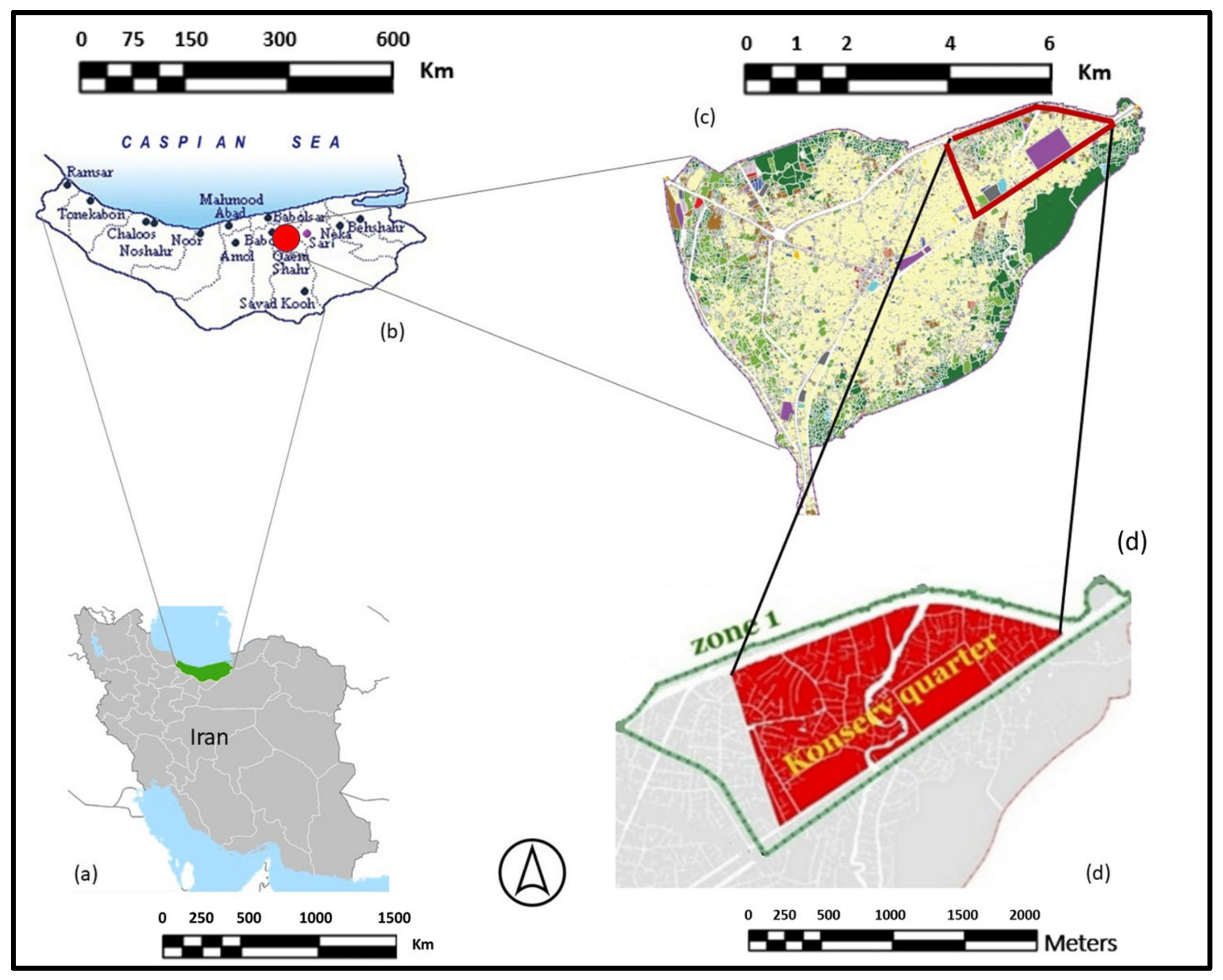
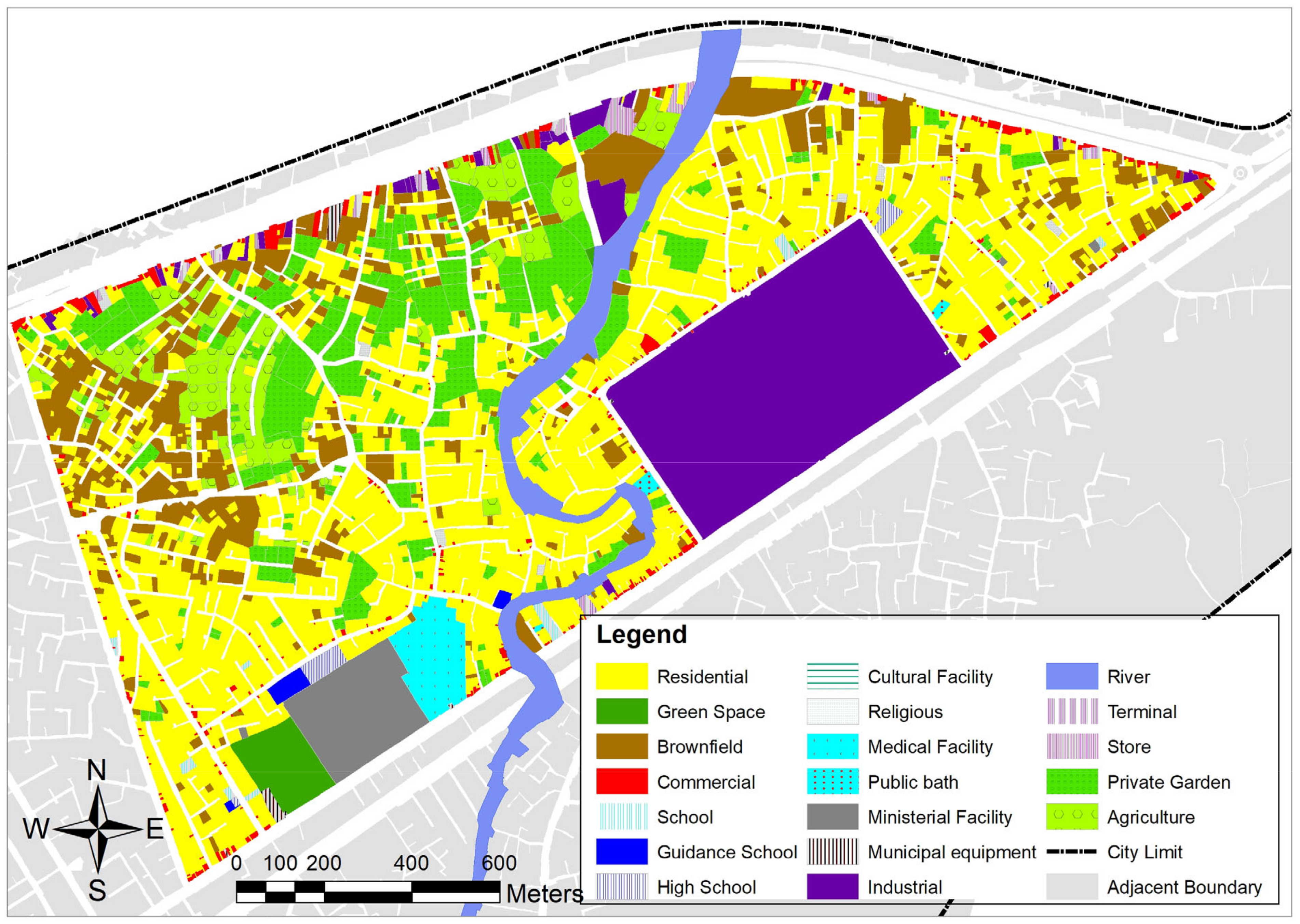
3.1. Case Study
3.2. Methodology
3.2.1. Overview
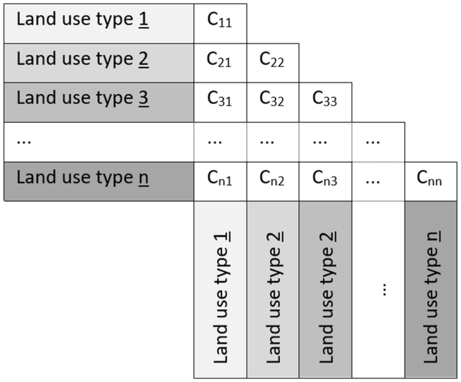
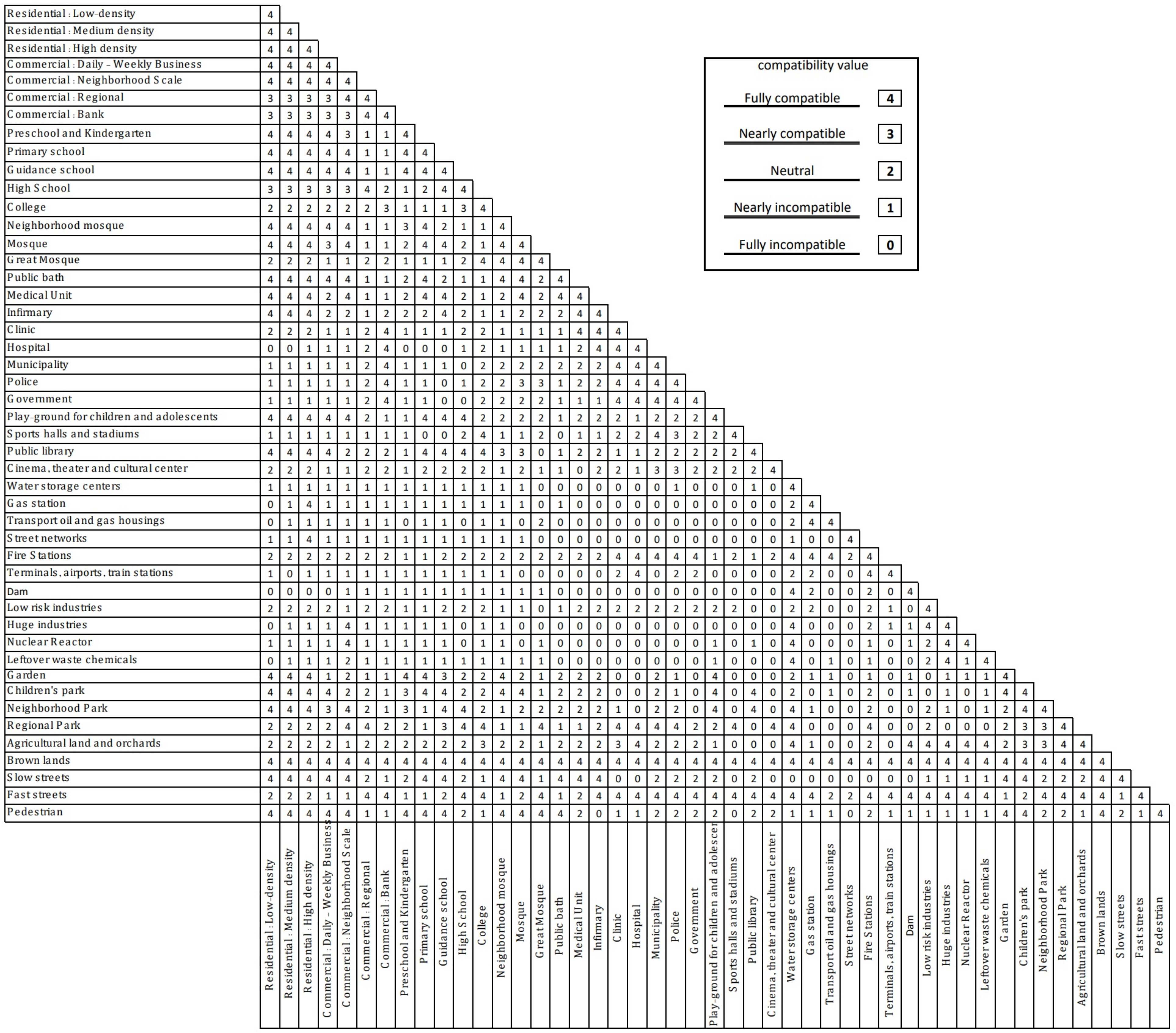
3.2.2. Defining Compatibility Values
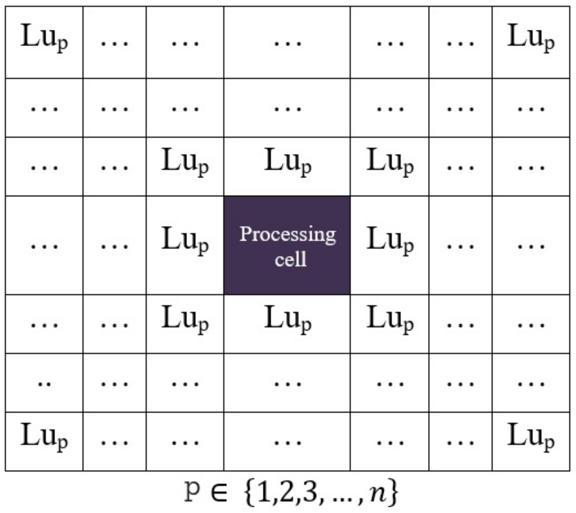
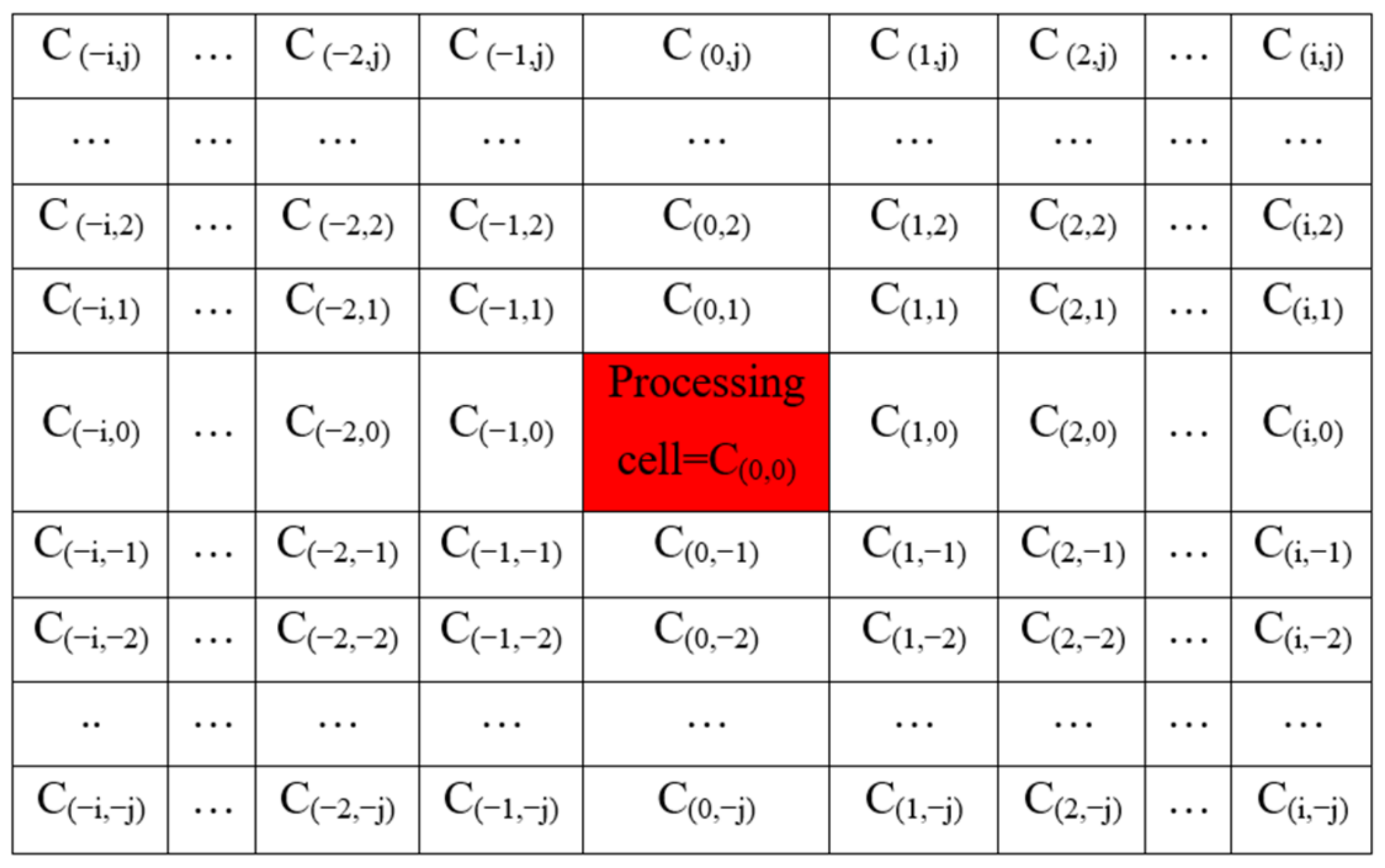
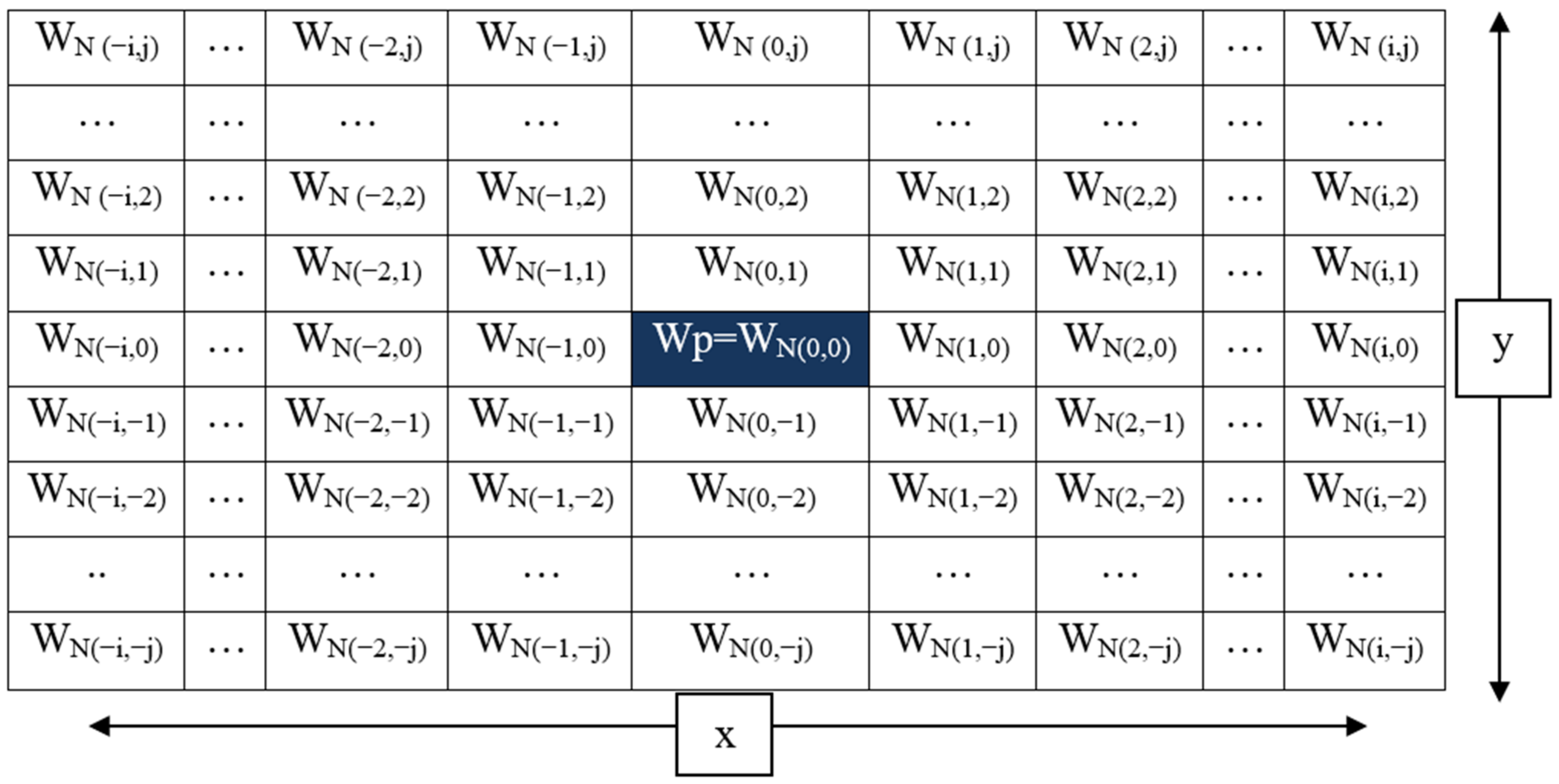
3.2.3. Spatial Analysis of Neighborhood Effects
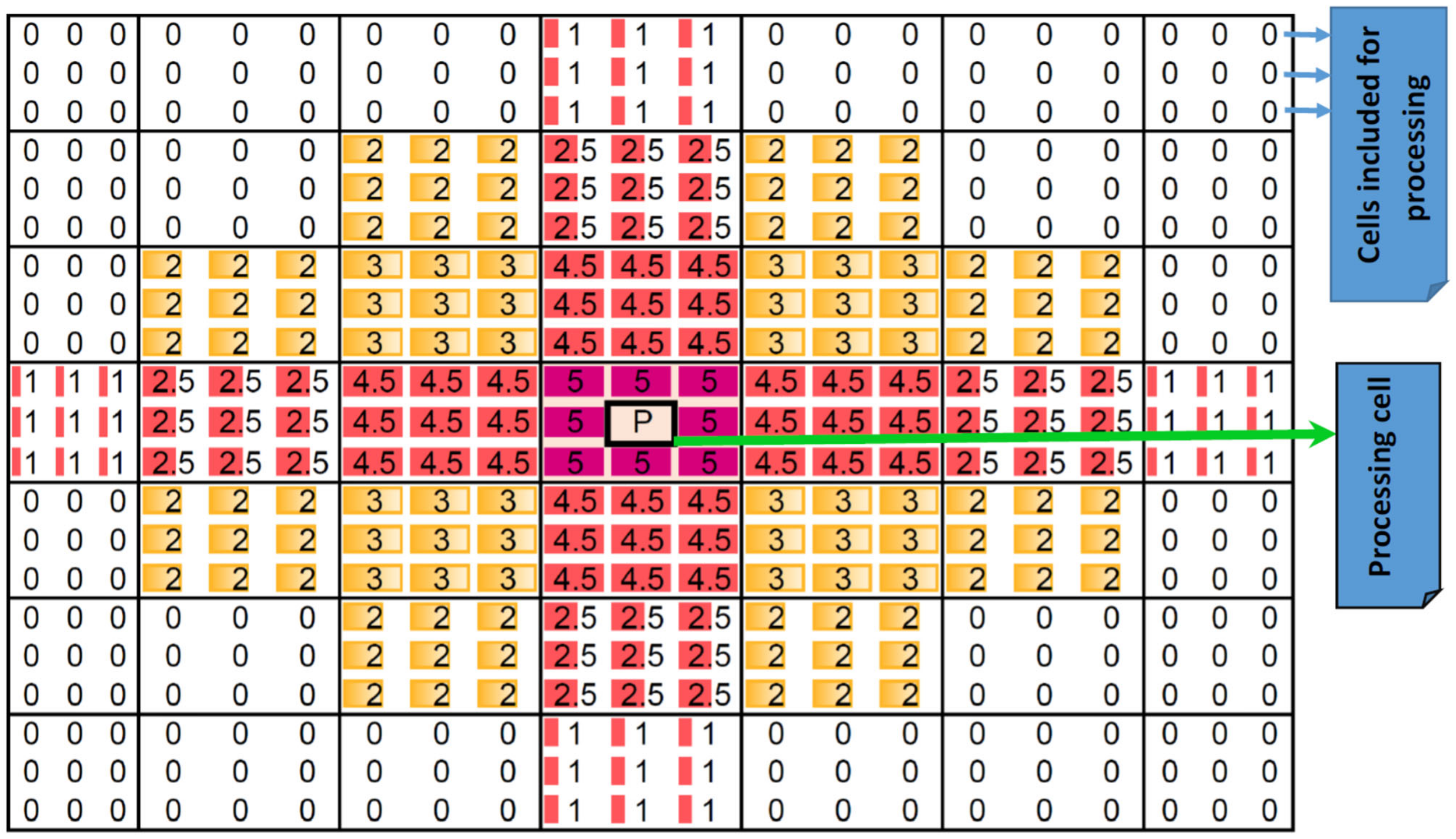
3.2.4. Computation of Cell Values
- The variable “m” represents the distance from the central cell to the edge of the neighboring radius in the x-axis, which is calculated as (x − 1)/2.
- The variable “n” represents the distance from the central cell to the edge of the neighboring radius in the y-axis, calculated as (y − 1)/2.
- “WN” denotes the weight assigned to each cell within the neighborhood, which depends on its distance from the cell under study.
- “C” represents the compatibility level corresponding to the specific land-use category of the cell under study.
- “Cp” denotes the points acquired by the cell under study based on the compatibility level.
3.2.5. Implementation in GIS
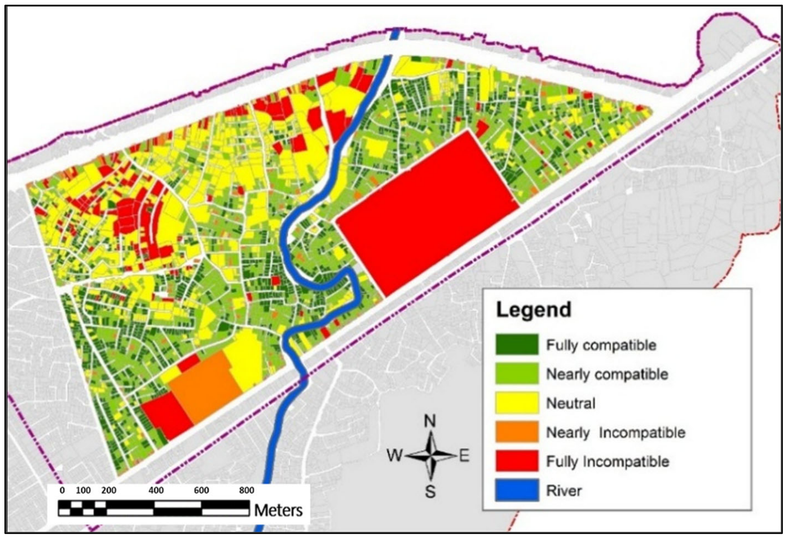
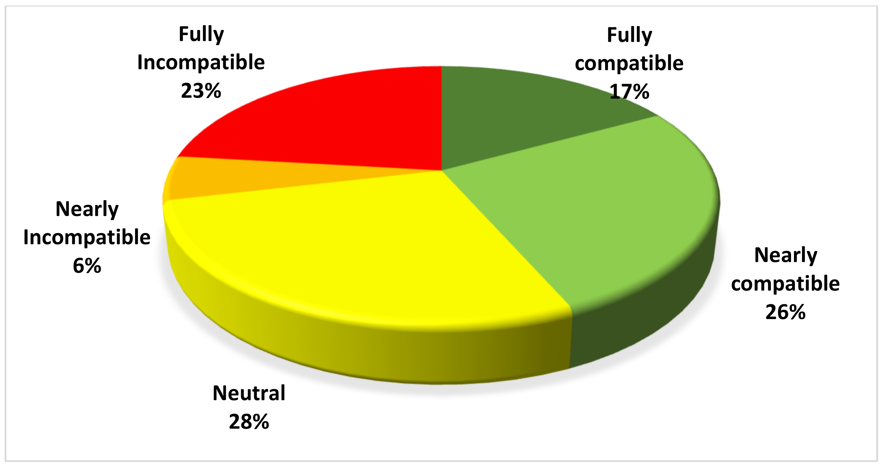
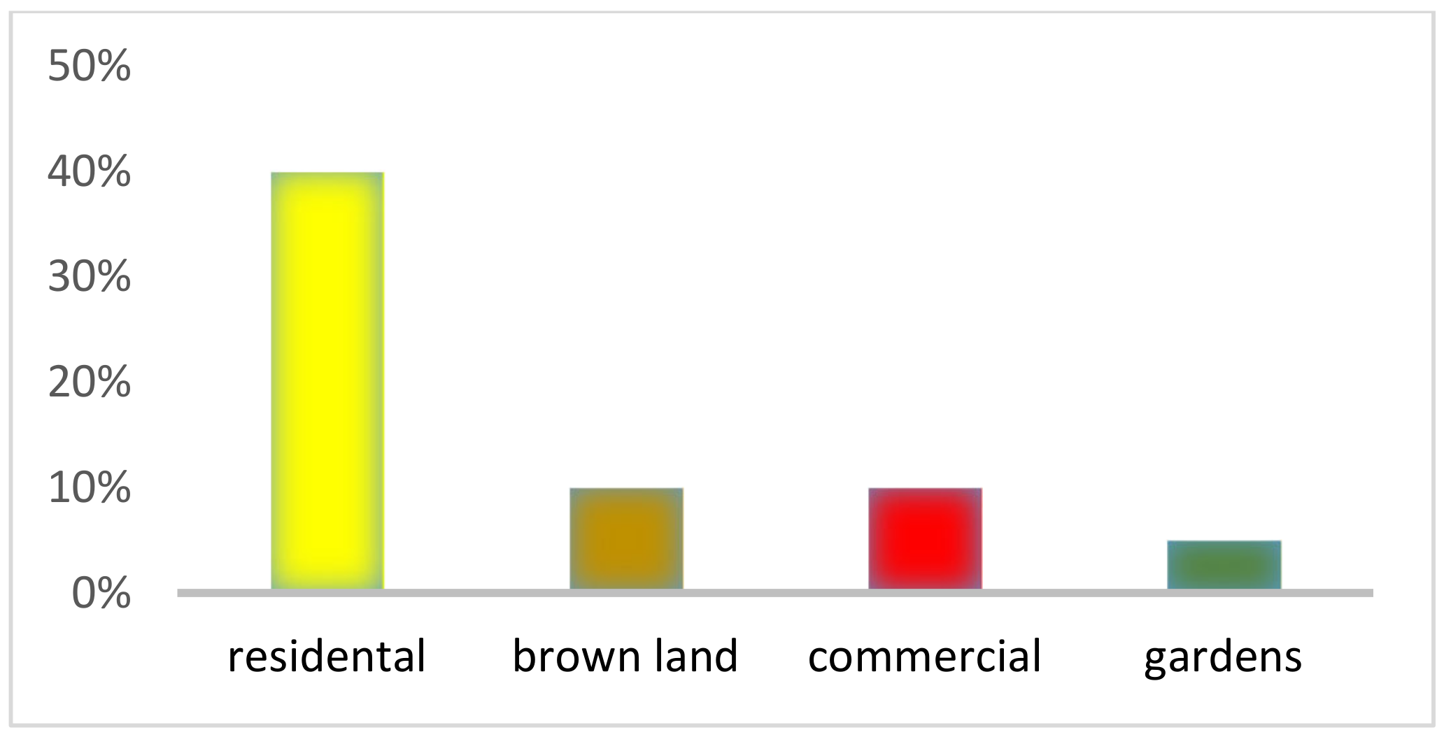
4. Findings
- The effect radii for industrial and non-urban uses were systematically varied from 100 to 500 m in 100 m intervals to assess the impacts on proximal residential area compatibility. As the radii were increased, more residential areas shifted from completely compatible to relatively or completely incompatible in the model outputs, affirming the technique’s ability to realistically capture extended impact zones.
- The model outputs were compared with observed land-use conflicts reported by residents and planning authorities through surveys and public forums. Approximately 84% of the identified and reported conflicts occurred in areas categorized as relatively or completely incompatible by the model, suggesting strong validity in the model’s categorization.
- Sensitivity analysis was undertaken by varying the cell size resolution from 1 to 10 m. While some minor variations occurred with smaller cell sizes below 5 m, the overall compatibility patterns and hotspots remained consistent, demonstrating the robustness of the model across scales.
5. Discussion
6. Conclusions
Author Contributions
Funding
Institutional Review Board Statement
Informed Consent Statement
Data Availability Statement
Conflicts of Interest
References
- Michalos, A.C. Encyclopedia of Quality of Life and Well-Being Research; Springer: Dordrecht, The Netherlands, 2014; Volume 171. [Google Scholar]
- Samat, N.; Mahamud, M.A.; Tan, M.L.; Maghsoodi Tilaki, M.J.; Tew, Y.L. Modelling land cover changes in peri-urban areas: A case study of george town conurbation, Malaysia. Land 2020, 9, 373. [Google Scholar] [CrossRef]
- Kılkış, Ş. Urban emissions and land use efficiency scenarios towards effective climate mitigation in urban systems. Renew. Sustain. Energy Rev. 2022, 167, 112733. [Google Scholar] [CrossRef]
- Zheng, H.; Wu, Y.; He, H.; Delang, C.O.; Qian, J.; Lu, J.; Yao, Z.; Li, G. Urban land use eco-efficiency and improvement in the western region of China. J. Clean. Prod. 2023, 412, 137385. [Google Scholar] [CrossRef]
- Rahman, M.M.; Szabó, G. Multi-objective urban land use optimization using spatial data: A systematic review. Sustain. Cities Soc. 2021, 74, 103214. [Google Scholar] [CrossRef]
- Taleshi, M.; Ghobadi, A. Urban land use sustainability assessment through evaluation of compatibility matrix case study: Karaj City. OIDA Int. J. Sustain. Dev. 2012, 3, 57–64. [Google Scholar]
- Iannillo, A.; Fasolino, I. Land-use mix and urban sustainability: Benefits and indicators analysis. Sustainability 2021, 13, 13460. [Google Scholar] [CrossRef]
- Fu, X.-L.; Zhou, J.; Tang, W.-W.; Liu, Y.; Li, Z.-L.; Li, P.; Chen, J. Study on the compatibility effect and active constituents of atractylodis rhizoma in ermiao wan against acute gouty arthritis. J. Ethnopharmacol. 2021, 279, 114353. [Google Scholar] [CrossRef]
- Freestone, R.; Favaro, P. The social sustainability of smart cities: A conceptual framework. City Cult. Soc. 2022, 29, 100460. [Google Scholar]
- Huang, G.; Li, D.; Zhu, X.; Zhu, J. Influencing factors and their influencing mechanisms on urban resilience in China. Sustain. Cities Soc. 2021, 74, 103210. [Google Scholar] [CrossRef]
- Luan, C.; Liu, R.; Peng, S. Land-use suitability assessment for urban development using a GIS-based soft computing approach: A case study of Ili Valley, China. Ecol. Indic. 2021, 123, 107333. [Google Scholar] [CrossRef]
- Hersperger, A.M.; Oliveira, E.; Pagliarin, S.; Palka, G.; Verburg, P.; Bolliger, J.; Grădinaru, S. Urban land-use change: The role of strategic spatial planning. Glob. Environ. Change 2018, 51, 32–42. [Google Scholar] [CrossRef]
- Manzello, S.L. Encyclopedia of Wildfires and Wildland-Urban Interface (WUI) Fires; Springer: Berlin/Heidelberg, Germany, 2020. [Google Scholar]
- Zhuo, Y.; Zheng, H.; Wu, C.; Xu, Z.; Li, G.; Yu, Z. Compatibility mix degree index: A novel measure to characterize urban land use mix pattern. Comput. Environ. Urban Syst. 2019, 75, 49–60. [Google Scholar] [CrossRef]
- Siegel, K.; Farah Perez, A.; Kinnebrew, E.; Mills-Novoa, M.; Ochoa, J.; Shoffner, E. Integration of qualitative and quantitative methods for land-use-change modeling in a deforestation frontier. Conserv. Biol. 2022, 36, e13924. [Google Scholar] [CrossRef] [PubMed]
- Koroso, N.H.; Zevenbergen, J.A.; Lengoiboni, M. Urban land use efficiency in Ethiopia: An assessment of urban land use sustainability in Addis Ababa. Land Use Policy 2020, 99, 105081. [Google Scholar] [CrossRef]
- Shen, X.; Wang, X.; Zhang, Z.; Lu, Z.; Lv, T. Evaluating the effectiveness of land use plans in containing urban expansion: An integrated view. Land Use Policy 2019, 80, 205–213. [Google Scholar] [CrossRef]
- Yang, J.; Yang, Y.; Tang, W. Development of evaluation model for intensive land use in urban centers. Front. Archit. Res. 2012, 1, 405–410. [Google Scholar] [CrossRef]
- Li, Y.; Zhang, S. Urban Land Use Analysis. In Applied Research Methods in Urban and Regional Planning; Springer: Berlin/Heidelberg, Germany, 2022; pp. 269–288. [Google Scholar]
- Ahadnejad Reveshty, M.; Tahmasebi Moghaddam, H.; Shami, F.; Moharrami, S. Spatial explanation of urban sprawl phenomenon (Case study: Qaemshahr city). J. Urban Soc. Geogr. 2019, 6, 1–13. [Google Scholar]
- Lagopoulos, A.P. Clarifying theoretical and applied land-use planning concepts. Urban Sci. 2018, 2, 17. [Google Scholar] [CrossRef]
- Rounsevell, M.D.; Pedroli, B.; Erb, K.-H.; Gramberger, M.; Busck, A.G.; Haberl, H.; Kristensen, S.; Kuemmerle, T.; Lavorel, S.; Lindner, M. Challenges for land system science. Land Use Policy 2012, 29, 899–910. [Google Scholar] [CrossRef]
- Filatova, T. Empirical agent-based land market: Integrating adaptive economic behavior in urban land-use models. Comput. Environ. Urban Syst. 2015, 54, 397–413. [Google Scholar] [CrossRef]
- Liang, H.; Liu, W.; Liu, H.; Ling, Y.; Liu, Y. Coupling relationship between socio-economy benefits and eco-environment benefits of land use in Shenzhen City. Sci. Geogr. Sin. 2008, 28, 636–641. [Google Scholar]
- Nakamura, H. Relationship among land price, entrepreneurship, the environment, economics, and social factors in the value assessment of Japanese cities. J. Clean. Prod. 2019, 217, 144–152. [Google Scholar] [CrossRef]
- Karakayacı, Z. Regression analysis for the factor affecting on farm land/urban land value in urban sprawl. Turk. J. Agric.—Food Sci. Technol. 2018, 6, 1357–1361. [Google Scholar] [CrossRef]
- Schüle, S.A.; Gabriel, K.M.; Bolte, G. Relationship between neighbourhood socioeconomic position and neighbourhood public green space availability: An environmental inequality analysis in a large German city applying generalized linear models. Int. J. Hyg. Environ. Health 2017, 220, 711–718. [Google Scholar] [CrossRef]
- Chisholm, M. Location and Land Use: Toward a General Theory of Land Rent; JSTOR: New York, NY, USA, 1966. [Google Scholar]
- Clapp, J.M. Urban land use succession under risk. Urban Stud. 1977, 14, 73–77. [Google Scholar] [CrossRef]
- Lee, Y. A conceptual discussion and an empirical analysis of commercial land-use succession. Environ. Plan. A 1974, 6, 655–674. [Google Scholar] [CrossRef]
- Smith, P.J.; McCann, L.D. Residential land use change in inner Edmonton. Ann. Assoc. Am. Geogr. 1981, 71, 536–551. [Google Scholar] [CrossRef]
- Liu, F. Environmental Justice Analysis: Theories, Methods, and Practice; CRC Press: Boca Raton, FL, USA, 2001. [Google Scholar]
- Gao, P.; Li, Y.; Gong, J.; Huang, G. Urban land-use planning under multi-uncertainty and multiobjective considering ecosystem service value and economic benefit-A case study of Guangzhou, China. Ecol. Complex. 2021, 45, 100886. [Google Scholar] [CrossRef]
- Verma, P.; Singh, P.; Singh, R.; Raghubanshi, A. Urban Ecology: Emerging Patterns and Social-Ecological Systems; Elsevier: Amsterdam, The Netherlands, 2020. [Google Scholar]
- Fu, Y.; Zhou, T.; Yao, Y.; Qiu, A.; Wei, F.; Liu, J.; Liu, T. Evaluating efficiency and order of urban land use structure: An empirical study of cities in Jiangsu, China. J. Clean. Prod. 2021, 283, 124638. [Google Scholar] [CrossRef]
- Tonne, C.; Adair, L.; Adlakha, D.; Anguelovski, I.; Belesova, K.; Berger, M.; Brelsford, C.; Dadvand, P.; Dimitrova, A.; Giles-Corti, B. Defining pathways to healthy sustainable urban development. Environ. Int. 2021, 146, 106236. [Google Scholar] [CrossRef]
- Taleai, M.; Sharifi, A.; Sliuzas, R.; Mesgari, M. Evaluating the compatibility of multi-functional and intensive urban land uses. Int. J. Appl. Earth Obs. Geoinf. 2007, 9, 375–391. [Google Scholar] [CrossRef]
- Pahlavani, P.; Sheikhian, H.; Bigdeli, B. Evaluation of residential land use compatibilities using a density-based IOWA operator and an ANFIS-based model: A case study of Tehran, Iran. Land Use Policy 2020, 90, 104364. [Google Scholar] [CrossRef]
- Sadiq, F.K.; Ya’u, S.L.; Aliyu, J.; Maniyunda, L.M. Evaluation of land suitability for soybean production using GIS-based multi-criteria approach in Kudan Local Government area of Kaduna State Nigeria. Environ. Sustain. Indic. 2023, 20, 100297. [Google Scholar] [CrossRef]
- Maleki, J.; Hakimpour, F.; Masoumi, Z. A parcel-level model for ranking and allocating urban land-uses. ISPRS Int. J. Geo-Inf. 2017, 6, 273. [Google Scholar] [CrossRef]
- Wang, A.; Wang, H.; Chan, E.H. The incompatibility in urban green space provision: An agent-based comparative study. J. Clean. Prod. 2020, 253, 120007. [Google Scholar] [CrossRef]
- Shi, H.; Zhao, M.; Chi, B. Behind the land use mix: Measuring the functional compatibility in urban and sub-urban areas of China. Land 2021, 11, 2. [Google Scholar] [CrossRef]
- Chakraborty, A.; McMillan, A. GIS and scenario analysis: Tools for better urban planning. In Comprehensive Geographic Information Systems; Elsevier: Amsterdam, The Netherlands, 2017; pp. 371–380. [Google Scholar]
- Cai, G.; Zhang, J.; Du, M.; Li, C.; Peng, S. Identification of urban land use efficiency by indicator-SDG 11.3.1. PLoS ONE 2020, 15, e0244318. [Google Scholar]
- Brown, G.; Raymond, C.M. Methods for identifying land use conflict potential using participatory mapping. Landsc. Urban Plan. 2014, 122, 196–208. [Google Scholar] [CrossRef]
- De Jong, L.; De Bruin, S.; Knoop, J.; van Vliet, J. Understanding land-use change conflict: A systematic review of case studies. J. Land Use Sci. 2021, 16, 223–239. [Google Scholar] [CrossRef]
- Pourmohammadi, M.R. Urban Land Use Planning; SAMT Publications: Tehran, Iran, 2003. (In Persian) [Google Scholar]
- Wei, R.; Ye, C.; Sui, T.; Ge, Y.; Li, Y.; Li, J. Combining spatial response features and machine learning classifiers for landslide susceptibility mapping. Int. J. Appl. Earth Obs. Geoinf. 2022, 107, 102681. [Google Scholar] [CrossRef]
- Chakir, R.; Le Gallo, J. Spatial Autocorrelation in Econometric Land Use Models: An Overview. In Advances in Contemporary Statistics and Econometrics: Festschrift in Honor of Christine Thomas-Agnan; Springer: Cham, Switzerland, 2021; pp. 339–362. [Google Scholar]
- Overmars, K.d.; De Koning, G.; Veldkamp, A. Spatial autocorrelation in multi-scale land use models. Ecol. Model. 2003, 164, 257–270. [Google Scholar] [CrossRef]
- Li, L.; Tang, H.; Lei, J.; Song, X. Spatial autocorrelation in land use type and ecosystem service value in Hainan Tropical Rain Forest National Park. Ecol. Indic. 2022, 137, 108727. [Google Scholar] [CrossRef]
- Kangas, K.; Brown, G.; Kivinen, M.; Tolvanen, A.; Tuulentie, S.; Karhu, J.; Markovaara-Koivisto, M.; Eilu, P.; Tarvainen, O.; Similä, J. Land use synergies and conflicts identification in the framework of compatibility analyses and spatial assessment of ecological, socio-cultural and economic values. J. Environ. Manag. 2022, 316, 115174. [Google Scholar] [CrossRef] [PubMed]
- Lozada, A.; Bertin, A. Spatial autocorrelation signatures of ecological determinants on plant community characteristics in high Andean wetlands. Sci. Rep. 2022, 12, 13770. [Google Scholar] [CrossRef] [PubMed]
- Tang, X.; Li, C.Z.; Jiang, L.; Lai, X.; Zhang, L. A Spatial Autocorrelation Analysis for Land Use Change in the Guangdong-Hong Kong-Macao Greater Bay Area. In Proceedings of the 26th International Symposium on Advancement of Construction Management and Real Estate, Beijing, China, 20–22 November 2021; Springer: Berlin/Heidelberg, Germany, 2021. [Google Scholar]
- Wang, Z.; Han, Q.; De Vries, B. Land use spatial optimization using accessibility maps to integrate land use and transport in urban areas. Appl. Spat. Anal. Policy 2022, 15, 1193–1217. [Google Scholar] [CrossRef]
- Yang, Q.; Pu, L.; Jiang, C.; Gong, G.; Tan, H.; Wang, X.; He, G. Unveiling the spatial-temporal variation of urban land use efficiency of Yangtze River Economic Belt in China under carbon emission constraints. Front. Environ. Sci. 2023, 10, 1096087. [Google Scholar] [CrossRef]
- Burghardt, K.; Uhl, J.H.; Lerman, K.; Leyk, S. Road network evolution in the urban and rural United States since 1900. Comput. Environ. Urban Syst. 2022, 95, 101803. [Google Scholar] [CrossRef]
- Sun, S.; Parker, D.C.; Brown, D.G. From an agent-based laboratory to the real world: Effects of “neighborhood” size on urban sprawl. Comput. Environ. Urban Syst. 2023, 99, 101889. [Google Scholar] [CrossRef]


Disclaimer/Publisher’s Note: The statements, opinions and data contained in all publications are solely those of the individual author(s) and contributor(s) and not of MDPI and/or the editor(s). MDPI and/or the editor(s) disclaim responsibility for any injury to people or property resulting from any ideas, methods, instructions or products referred to in the content. |
© 2023 by the authors. Licensee MDPI, Basel, Switzerland. This article is an open access article distributed under the terms and conditions of the Creative Commons Attribution (CC BY) license (https://creativecommons.org/licenses/by/4.0/).
Share and Cite
Mansourihanis, O.; Maghsoodi Tilaki, M.J.; Yousefian, S.; Zaroujtaghi, A. A Computational Geospatial Approach to Assessing Land-Use Compatibility in Urban Planning. Land 2023, 12, 2083. https://doi.org/10.3390/land12112083
Mansourihanis O, Maghsoodi Tilaki MJ, Yousefian S, Zaroujtaghi A. A Computational Geospatial Approach to Assessing Land-Use Compatibility in Urban Planning. Land. 2023; 12(11):2083. https://doi.org/10.3390/land12112083
Chicago/Turabian StyleMansourihanis, Omid, Mohammad Javad Maghsoodi Tilaki, Samira Yousefian, and Ayda Zaroujtaghi. 2023. "A Computational Geospatial Approach to Assessing Land-Use Compatibility in Urban Planning" Land 12, no. 11: 2083. https://doi.org/10.3390/land12112083
APA StyleMansourihanis, O., Maghsoodi Tilaki, M. J., Yousefian, S., & Zaroujtaghi, A. (2023). A Computational Geospatial Approach to Assessing Land-Use Compatibility in Urban Planning. Land, 12(11), 2083. https://doi.org/10.3390/land12112083