Article

The Configurational Structures of Social Spaces: Space Syntax and Urban Morphology in the Context of Analytical, Evidence-Based Design

The Bartlett School of Architecture, UCL, London WC1H 0QB, UK
Land 2023, 12(11), 2084; https://doi.org/10.3390/land12112084
Submission received: 3 September 2023 / Revised: 14 November 2023 / Accepted: 16 November 2023 / Published: 20 November 2023
(This article belongs to the Special Issue Urban Morphology: A Perspective from Space)

Abstract

:
This article presents an argument for the enhanced utilisation of urban morphology in urban design, drawing inspiration from space syntax theory and methodologies, advocating for the integration of social, economic, and cultural considerations alongside physical structures. This perspective shift entails transitioning from descriptive analysis to quantitative inquiries for the prediction and assessment of urban dynamics. By incorporating spatial analysis and socio-economic factors, urban morphology offers a competent understanding of the complexities inherent to urban environments. This comprehension supports the development of evidence-based designs and predictive models that enable such an approach in urban design. To operationalise this approach, the article introduces a methodology that interlinks urban morphology and design through a cyclic process encompassing analysis, design, evaluation, and further design development. This framework is illustrated through the case study of Jilin City, where an assessment of the public transport system led to a comprehensive urban design strategy. The study demonstrates how urban morphology insights, supported by analytical investigations enabled by space syntax methodology, can actively influence urban design and planning practices. By effectively embedding this morphological approach, urban designers and planners acquire the tools needed to navigate the evolving urban systems while respecting the interplay between physical structures and human existence. The article concludes by highlighting the need for an ongoing evolution of this approach to maintain relevance in shaping future urban settings.

1. Introduction: The Fundamental Questions of Urban Morphology

Urban morphology, as it is conventionally defined, investigates the intricacies of urban forms. It is customary to refer to urban morphology as an exploration of constituent urban morphological elements, including buildings, development zones, urban blocks, plots, and more. While certain urban morphologists attempt to broaden the scope of urban morphology to embrace the interplay between built forms and societal, cultural, and economic contexts [1], the diverse approaches to urban morphology predominantly remain situated on a platform of investigating the physical attributes of cities. These attributes are rooted in spatial arrangements, architectural typologies, and morphological patterns that have permanently moulded urban environments across history [2].
It is fair to say that urban morphology, as a distinct realm of scholarly inquiry, does not possess a particularly extensive lineage, even though the practical application of urban morphology, embraced by urban planners, goes back to antiquity [3]. The meticulously planned cities of ancient China, India, Persia, Mesopotamia, the Near East, Egypt, Greece, Rome, and beyond, attest to the knowledge that city-makers held for the coordinated combination of physical attributes and urban configurations to create a city. This tradition persevered into modern times, spanning the medieval period, the Renaissance, both pre- and post-industrial, and modern eras. Nevertheless, these collective endeavours did not coalesce into a methodical exploration of the urban form until the 20th century. It was during this era that professionals from diverse fields of architecture, urban planning, and urban geography began the process of shaping what we presently identify as the discipline of urban morphology [2,4,5,6,7,8].
To comprehend the present state of urban morphology as a distinct academic domain, it becomes essential to explore the diverse range of approaches that have emerged over the past century or so. Regardless of their specific focuses, these approaches can be broadly grouped into three categories [2]. Primarily, there are approaches centred around the historical progression and evolution of cities, engaging with the shifts and alterations that urban form and morphology have undergone over time. This line of inquiry highlights an examination of urban forms, their expansion, and their metamorphosis throughout various historical periods. Following this are the approaches associated with what is commonly referred to as the typological schools of urban morphology. Within this field, the scrutiny and categorisation of urban structures hinge on architectural typologies and the classifications of building styles. Here, the emphasis is placed on an investigation into the patterns and designs of buildings, and the resultant impact on the overarching urban fabric. The third overarching approach shares similarities with the preceding two, yet it incorporates quantitative metrics and analytical methodologies to establish a coherent foundation for cross-comparative analysis, facilitating a more comprehensive comprehension of diverse urban contexts [9,10].
In this article, the intention is not to extensively examine the diverse schools of urban morphology, as comprehensive investigations have been conducted in other contexts [2,5,7,11,12,13]. Instead, the emphasis of the discussion is redirected towards identifying the gaps within urban morphological studies and exploring potential approaches that might address these gaps. This process can start with this fundamental question: should urban morphology examine the physical component of the built form, or focus on the spaces between them?

2. An Intrinsic Challenge of Urban Morphology: Built Form versus Space Form

The question of whether urban morphology should primarily scrutinise the physical constituents of the built form or focus its attention towards the interstitial spaces between them is a nuanced consideration [14]. Both aspects hold intrinsic significance in comprehending the urban landscape (Figure 1). Examining the physical built components, such as structures and architectural typologies, offers insights into the tangible manifestations that shape urban environments. Conversely, investigating the spaces between these built elements uncovers the intricate networks, connections, and interactions that underpin the functionality and dynamics of urban spaces. Striking a balance between these perspectives could foster a more comprehensive understanding of urban morphology, encompassing not only the tangible physical entities but also the connective spatial system that weaves the urban fabric together.
This opens the door to two additional inquiries that carry equal weight. The foremost among these queries is as follows: between these two approaches (concentrating on the physical form or centring on the vacant spaces among them), which of the two serves as a conduit to interlace urban morphology with the human, societal, and functional dimensions intrinsic to cities? The question involves a pivotal consideration of how urban form intertwines with the multifaceted aspects of human existence within cities. While an analysis primarily centred on the physical form grants insights into architectural aesthetics, formal compositions, and structural arrangements, exploring the spaces between structures unravels the intricate patterns of movement, social interactions, and functional interdependencies that animate urban life [15,16,17]. A balanced integration of both perspectives could potentially forge a more comprehensive connection between urban morphology and the intricate tapestry of human experiences, societal dynamics, and urban functionality.
This brings us to the second pivotal question concerning the dichotomy between the physical built elements and the interstitial spaces: how can we effectively analyse and gain insight into the living spaces nestled between the city’s physical components? Or, in other words, does the conventional arsenal of metrics, such as length, area, and volume, suffice to fully apprehend the intricate contours and operational dynamics of urban spaces? The customary morphological measures, while essential, might offer a limited perspective, potentially failing to capture the intangible yet profound qualities that define the essence of these spaces. Navigating this inquiry necessitates a more encompassing framework that recognises not only the dimensions and geometries, but also the experiential, social, and functional dimensions intrinsic to urban space.
Even if we uncover a methodology to concurrently study and scrutinise the city’s physical components alongside the interstitial living spaces, a subsequent dilemma arises concerning the alignment of this analysis with the social and human dimensions that define the city. In actuality, these two aforementioned inquiries appear to be two facets of a singular enigma; the imperative to confer significance upon urban morphology necessitates a profound exploration of human activities within the city, thereby requiring a mechanism to interlink the living spaces with human experience [15]. While it is evident that individuals engage, to a certain extent, with the physical components of space, viewing them as either obstructions or aesthetic elements, the primary link between the urban realm and human presence unfolds within the very interstitial spaces: the living space.
Despite the attempts undertaken by diverse urban morphologists across various schools of thought within urban morphology, the field remains marked by a scarcity of comprehensive theoretical frameworks adept at seamlessly unifying the imperative to scrutinise interstitial spaces with the individuals who inhabit them. In the following section, the existence of a theoretical framework capable of achieving this cohesion is discussed and its evolution over the course of the past five decades is described.

3. Can Urban Morphology Offer a Theoretical Framework for Unifying the Urban Space with Its Inhabitants?

Originating as a response to the void in urban morphology outlined in the preceding discussion, space syntax, a theoretical framework pioneered by Bill Hillier and his colleagues, began to take shape during the 1970s [18,19,20]. This approach carries a dual-fold premise. Firstly, it asserts that space and society constitute an intertwined paradigm, where space substantially transcends its role as a mere backdrop to human endeavours. Instead, it emerges as a dynamic entity moulded by human activities and, in turn, influences and shapes those very activities [15,21]. Remarkably intuitive though it may be, the explicit discourse on the man–environment or space–society paradigm appears conspicuously absent in other prevailing urban morphological theories.
This proposition immediately surmounts the obstacle of treating urban morphology as an abstract study confined solely to form, addressing its traditional challenge of seamlessly aligning urban form with societal dynamics in a streamlined manner. Nevertheless, for this approach to yield effective outcomes, a second, equally pivotal, assertion comes to the forefront. This secondary assertion pertains to the intrinsic nature of urban or architectural space as a configurational entity [17,22,23,24]. Here, space syntax offers a resolution through its assertion that any living space fundamentally embodies a configurational system—a composite of spaces in which every sub-space within the system maintains a topological relationship with others. This relationship is delineated by how these sub-spaces are navigated or utilised by human interaction. In essence, to truly imbue the space–society paradigm with significance, an approach becomes requisite that can decipher the intricacies of human behaviour within a spatial system.
These two foundational propositions usher in a multitude of inquiries demanding illumination. What, precisely, constitutes the configuration of distinct spatial spaces? How can the elements of configuration, or the sub-spaces within the broader configurational system, be meticulously delineated and then subjected to meaningful analysis? To what degree does the definition of these configurational components hinge upon the intricate web of human interactions? What analytical methodologies should be employed to unveil the inherent configurational traits of these spaces? How might the scrutiny of spatial configuration furnish insights into the operational dynamics of cities? In its evolution in the past fifty years, and predominantly based on empirical, evidence-based research, space syntax has attempted to address such queries in two ways: firstly, by developing further sub-theories that can deal with various aspects of the space–society paradigm, and secondly, by developing methods and tools that generate tangible, analytical evidence.
As the trajectory of space syntax theory has progressed, a series of sub-theories have emerged, each aiming to clarify and underpin distinct facets of urban systems. One such theory is the concept of ‘natural movement’, which proposes that the movement stimulated by the spatial grid inherently fosters the vibrancy of the city’s life. This perspective challenges the conventional dichotomy between place and the act of moving between places. In tandem, the theory of ‘movement economy’ explains that urban activities adeptly adjust to capitalise on this movement’s potential [25]. An additional strand of thought, known as the ‘pervasive centrality’ theory, proposes that central functions permeate the network, producing a pattern that surpasses the expectations delineated by theories of poly-centrality [26]. Such an intricate pattern, more effectively captured through a configurational analysis of spatial networks, is advocated by Hillier [17,26]. Further theoretical constructs have been crafted, encompassing topics such as the following: ‘order and structure’ in urban systems [16,27], urban migration and ethnic clustering [28,29,30], behavioural dynamics and interactions within workplaces [31,32], the fusion of accessibility, density, and diversity to illuminate ‘spatial capitals’ [33], the cognitive understanding of spatial configuration and way-finding [34,35,36], encoding natural movement as an emerging bottom-up interaction between agents [37,38], as well as informal and organic urban growth [17,39,40]. This interconnected matrix of theories collectively establishes a diverse yet harmonised foundation, providing a comprehensive platform for the research conducted within the realm of space syntax.
While discussing the field of space syntax, it is important to acknowledge that it has been subject to various critiques. However, as most of these critiques have been addressed elsewhere (e.g., in reference [41]), this article does not primarily focus on them. It is worth noting that these critiques primarily examined methodological or representational aspects of space syntax, rather than its core propositions or specific research outputs. Additionally, they have overlooked the significant developments in space syntax over the past two decades, which are crucial in understanding its evolving and valuable role in the fields of architectural and urban design.

4. Spatio-Configurational Representation and Analysis of the Living Spaces: The Significance of Visibility and Movement

In tackling the complexities of spatial analysis, space syntax adopts a straightforward approach. It begins by pinpointing the most fundamental and prevalent patterns of interaction between individuals and space. This undertaking is underpinned by a dedicated focus on humanity’s predominant senses—vision and its principal function, movement—arguably the two quintessential facets that, if omitted from a city, would render it unrecognisable. The rationale behind this approach lies in comprehending the nuanced ways in which individuals engage with and deploy each component of a spatial system (Figure 2). By considering these aspects, a method of inquiry emerges that effectively unifies the spatial dimension of a city, defined by its tangible attributes, with the human dimension embodied by its inhabitants [15]. This foundational methodology, while seemingly simple, proves remarkably effective. It generates a framework capable of bridging the gaps inherent to urban morphology, thereby presenting a significant advancement within the field.
The space syntax methodological answer to the representation of the spatial system is based on breaking up the overall spatial system into smaller chunks and convex spaces. These convex spaces possess the unique quality that every location within a given space remains perceptible from any other point within the same space. While this approach offers a meaningful dissection of the spatial system, providing a valuable lens to explore the network of spaces accommodating stationary activities, it does not inherently encapsulate another pivotal feature intrinsic to any city: its movement network. To address this challenge, an alternative method of representation is introduced. This method constructs an interconnected network of movement lines, or ‘axial lines’, weaving together the longest and shortest lines of sight that traverse all convex spaces [42,43]. This network emerges as a blueprint of movement routes, capturing the skeletal structure of the city’s movement network. Through this innovation, a proficient methodology emerges—one capable of concurrently capturing both the geometrical and social attributes of the urban system, yielding a comprehensive perspective on its multifaceted nature (Figure 3).

5. From Spatial Representation to Spatial Analysis: Quantifying the Topological Characteristics of Urban Morphology

One of the primary gaps in most urban morphology approaches is the absence of a method that can systematically and analytically establish an understanding of an urban structure as a comprehensive system. To better grasp this concept, we must first define what is meant by an urban structure. An urban structure refers to the specific spatial arrangement, organisation, and composition of diverse elements within an urban area across different scales. This encompasses the distribution of buildings, open spaces, urban areas, infrastructure, transportation networks, and land uses, highlighting the importance of objectively comprehending the interrelationships between these components. An urban structure is also affected by the interplay between the configuration of the city as a whole, and the configuration of its parts [16,44]. Achieving such an understanding requires employing methods capable of explaining the inherent patterns of connectivity, hierarchy, and interactions within the urban system. This structural approach to comprehending cities should encompass the capacity to address various scales of the urban system, ranging from the very small to the very large. Moreover, it necessitates a methodology that facilitates the comparison of different urban systems or the various internal elements within any given urban system.
While a configurational representation or model of the spatial system constitutes a vital step towards unravelling the complexities of the urban environment, the subsequent need to decipher these configurational models to unveil the operational mechanisms of the city persists. Nevertheless, conventional methods of morphological analysis, reliant on the geometric attributes of urban form, appear to yield limited advantages in this pursuit. Acknowledging this difficulty, space syntax turns to an alternative avenue—one that aligns more closely with configurational models: topological analysis. This approach, pioneered by luminaries such as Christopher Alexander [45,46], hinges on graph mathematics and emerges as an appropriate means to tackle this challenge (Figure 4). Its suitability rests on its capacity to provide a methodological framework conducive to navigating the intricacies of spatial networks and capturing the essence of urban functionality.
However, the adoption of the space syntax methodology does not imply a complete abandonment of the traditional metrics inherent to urban morphology or a disregard for the geometric intricacies of an urban form. The graph-based, configurational analysis of an urban form is capable of operating in tandem with the more established geometry-based models. In fact, as the space syntax analysis evolved, it reintroduced the geometric attributes of urban form into the equation, particularly through the consideration of the angle of incidence between axial lines. This evolution extends even further by segmenting the axial lines into smaller fragments defined by the intersections of these lines [47]. Termed ‘segment-angular’ analysis, this method harmoniously reconciles the geometry and topology of the urban system within a single cohesive model, while it enhances its relevance to human navigation by emulating the inclination of individuals to traverse routes characterised by smoother directional changes, rather than abrupt turns (Figure 5). The segment–angular analysis opens doors for other types of modelling that could be very useful for large-scale models. The utilisation of road centrelines, which are increasingly available for all cities and regions, offers a major step towards creating spatial network models of the city.
While space syntax is often recognised for its distinctive analytical methods, such as axial, segment, or convex models, it has evolved well beyond its original methodologies. These expansions include approaches like Visual Graph Analysis (VGA) [48], vision-guided Agent-Based Modelling [37], origin-destination weighted network analysis [38,49], GIS-linked tools and software for conducting space syntax analysis within a GIS environment [50], Place Syntax—an amalgamation of accessibility and urban function analysis [51], and more recently, Integrated Urban Models (Figure 6), which aim to unify spatial attraction, land-use attraction, and density attraction into a comprehensive multi-modal spatial network model [52,53]. As new questions continue to emerge, the development of novel methods and tools becomes an inevitable and ongoing aspect of the field’s progression.

6. From Spatial Analysis to Spatial Design, or Can Urban Morphology Be Used Effectively in the Design and Planning Processes?

To grasp how urban morphology can seamlessly inform design, one must first recognise the fact that design is intrinsically a ‘process ’ that has two important inherent characteristics: it is sequential and iterative [54]. Viewing design through this lens effectively undoes the misconception that design could be an instantaneous generation of ideas. Instead, design should be considered as a progressive journey, in which we uncover the intricate interplay between intuitive and objective decision-making patterns in a cyclic process. This, consequently, emphasises a crucial argument: the nature of spatial design inherently resists immediate enactment; instead, it fundamentally unfolds as an evolutionary process. This process intrinsically mandates the merger of diverse functional considerations, harmonising within the spatial form. Therefore, spatial design essentially aligns itself with an approach of iterative development, one that seamlessly accommodates ‘user feedback’ garnered from the realms of ‘user experience’. This results in a constructive iteration loop, appropriately termed, by Hillier and Penn, a ‘virtuous circle’ [55]. Addressing the complexity of disparate functions that seamlessly intertwine and causally impact one another necessitates an approach firmly rooted in a ‘structural analysis’ of the urban fabric. Such an approach empowers a comprehensive grasp of the intricately interconnected urban functions [55].
In principle, the design process can be compartmentalised into discrete components, subject to individual examination, subsequently culminating in synthesis within the overarching design framework. Within this context, analysis emerges as not only pertinent to the process but also as an invaluable approach when there arises a necessity to infuse greater precision into the scrutiny of design constituents and their assessment against specific criteria.
The design process, in broad terms, is defined by what happens between a problem—encompassing a brief, a need, or a demand—and a solution, characterised by an outcome, an output, or a product (Figure 7, left). What happens between the beginning and end of the process normally entails a phase of idea generation followed by a phase of idea development. A critical aspect of this progression is the necessity to subject these ideas and solutions to an evaluation against a set of criteria, either introduced externally or emerging from within. During a typical design process, conjectures are frequently tested intuitively, with designers relying on their own discernment to gauge the feasibility of a design conjecture. However, as design concepts take shape, a more meticulous evaluation becomes requisite, aiming to ascertain whether a given design idea possesses the potential to evolve into an appropriate design solution for the project at hand (Figure 7, right).
Space syntax navigates this complexity using a two-fold strategy (Figure 8 and Figure 9). Firstly, it undertakes a series of comprehensive analyses on both city-wide and neighbourhood-wide scales, examining the spatial networks alongside associated socio-economic factors. This meticulous investigation reveals a discernible structural pattern intricately linked to human activities and urban functions. This scrutiny of urban structure enhances designers’ contextual understanding, facilitating the identification of inherent challenges and latent opportunities within the site. Furthermore, it holds the potential to inspire improved or more contextually relevant design concepts and solutions. Secondly, the analytical models crafted during the initial phase of the process serve as potent tools for scrutinising and appraising any design idea or alternative design proposals. This approach not only enables the integration of urban morphology within the design process but also significantly enriches the iterative cycle of conjecture-testing or solution-evaluation intrinsic to design endeavours. Notably, this evaluative process is conducted in an objective and quantitative manner, ushering the design process towards a more analytical and evidence-based trajectory.

7. Space Syntax and Analytical, Evidence-Based Design

The merits of analytical, evidence-based design have been documented elsewhere [32,54,56], but it is crucial to emphasise that urban morphology, as applied through the space syntax methodology, provides a tangible and meaningful platform for operationalising such a process. This argument suggests that any evidence-based approach intended for integration into the design process must possess three fundamental characteristics: it should be specifically spatial, inherently social, and intrinsically analytical. Moreover, evidence-informed urban design demands an inherent social dimension, given that any conceivable urban design endeavour invariably harbours a potent human and societal aspect. This imperative reverberates across the design process’s earliest stages, encompassing brief development, to its culminating juncture—the emergence of the final design. Hence, the presence of the human element is a prerequisite for any meaningful urban design endeavour. Lastly, an evidence-based process gains significance only when the distinct components of design undergo individual scrutiny before being deftly interwoven into a coherent whole. This integrative exercise invariably ushers the process towards an analytical trajectory, rendering the analytical aspect indispensable.
Expanding on the outlined urban design process, a model of the analytical design process can be shaped to introduce stages before and after idea generation and design development. This model has been extensively introduced elsewhere [54,56,57]. At each phase of this process, there is an analytical feedback loop, either as an analysis–synthesis or conjecture–test evaluation, which utilises analytical methods to assess and evaluate the outputs of each phase. Starting with an analytical sequence ‘baseline analysis’ prior to design inception aims to reveal contextual factors, constraints, and relevant aspects. Design solutions emerge after synthesising analytical investigation and broader considerations—social, economic, and political. Analytical tools scrutinise design ideas and identify the strengths and weaknesses of each design scenario. Rejected ideas lead to repetition until alignment with internal analysis and external consultations is achieved (Figure 8).
In the space syntax approach, spatial configuration analysis prevails during the baseline and evaluation stages, but composite models that combine configurational analysis with additional information to address specific issues could be developed and applied at the baseline and evaluation phases (Figure 9). The evaluation of the design brief, the development of spatial and integrated models, and the early design ideas constitute a phase of the design that we can call the ‘diagnosis phase’. After design option development, analytical methods developed in the diagnostic phase evaluate the design options to help the designers choose the right option, after which they can embark on a process of consulting stakeholders. When the design option is agreed upon by stakeholders, the process moves on to develop the design further until it reaches a satisfactory level. The phase in which design options are created, evaluated, consulted, and developed further could be called the ‘prognostic phase’. The important thing is that further iterations of the process are possible by going back to earlier stages and repeating the cycle until a desirable output is obtained (Figure 8 and Figure 9). In fact, since the entire process is driven by analysis and evidence, the final design can also provide a meaningful reflection on the original brief to identify the weaknesses of the brief and how it could be improved for the further iteration of the design process, or for the future continuation of the project (Figure 8).

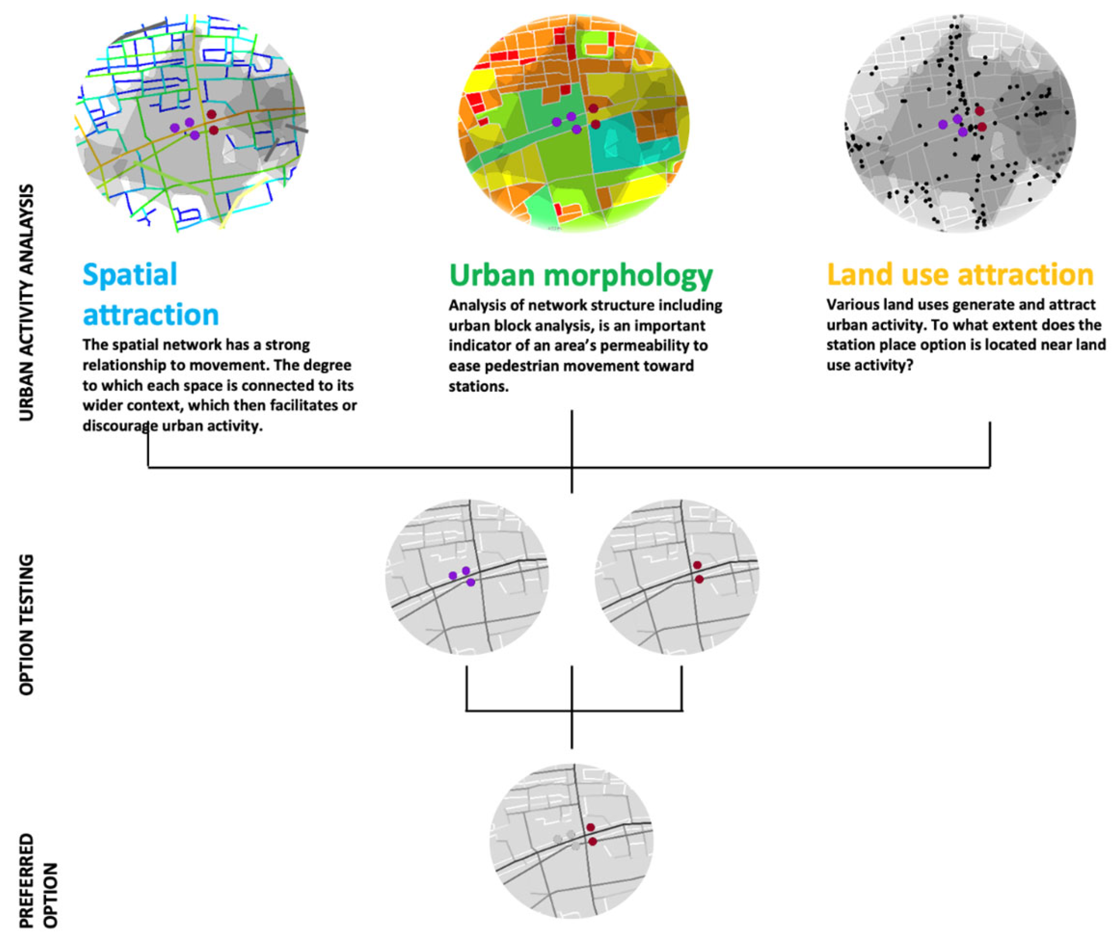
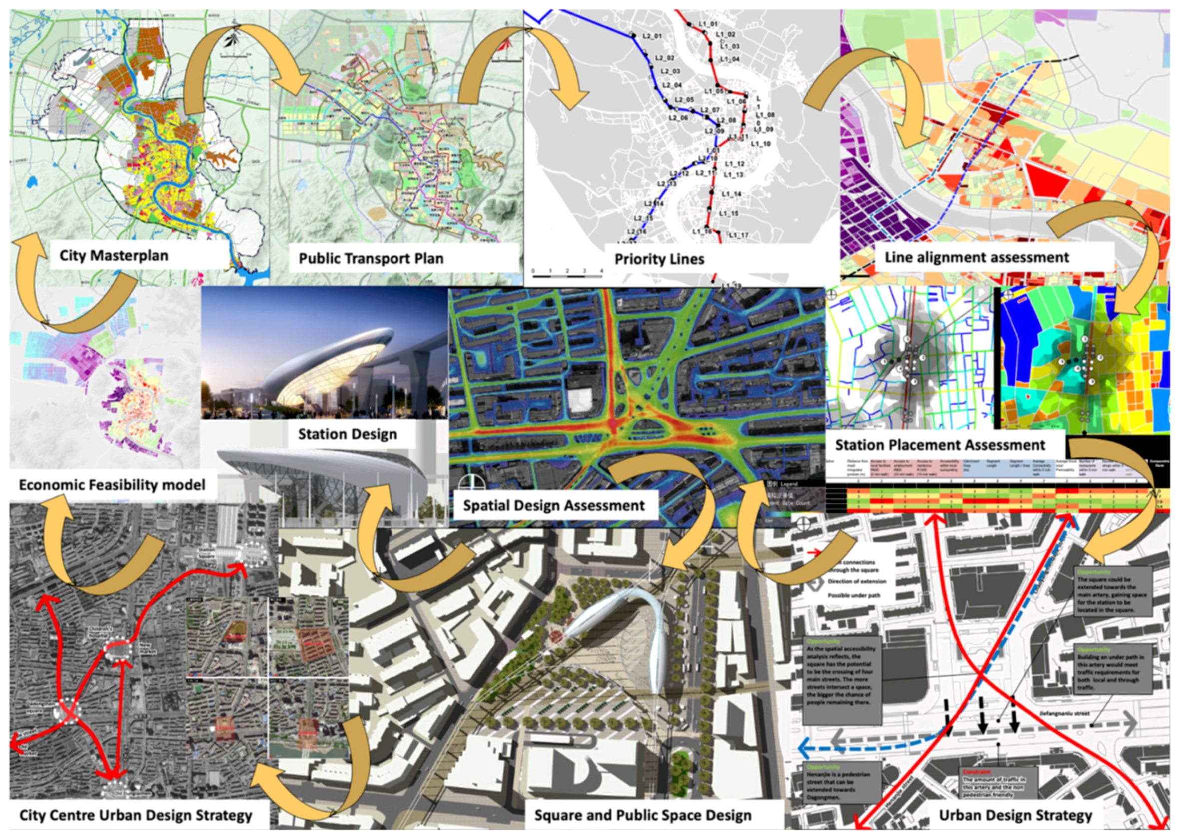
8. An Analytical, Network-Based, Multi-Scalar Approach to Urban Design and Planning: The Case Study of Jilin City, China

To demonstrate how urban morphology can be seamlessly integrated into the urban design process, this section of the article introduces a comprehensive case study. The study encompasses a range of urban design and planning initiatives on various scales, offering practical insights. The selected case is the city of Jilin in northern China, a rare instance where a comprehensive journey spanning wide-scale urban planning to detailed urban and architectural design was realised 1. Given the extensive array of analytical methods applied in this project, a detailed examination of every technical aspect falls outside the scope of this article. Instead, the focus remains primarily on explaining the process itself and showcasing the role of spatial and morphological analysis, in conjunction with socio-economic data, in informing and shaping the different stages of the urban design and planning process.
The journey began when city authorities commissioned the development of an ‘assessment model’ to optimise routes and station placements for a newly planned public transport (monorail) system. However, this evaluation needed to align with the city’s main masterplan and transport strategy (Figure 10). Initially focusing on assessing two lines, the project intended to expand its scope to cover all inner and outer city transport lines, along with associated stations, in subsequent phases. During the first project phase, it became evident that station locations in key public areas required a detailed study followed by an urban design process for four major city squares in the central parts of the city. This, in turn, led to the immediate necessity of developing architectural proposals for specialised stations within these public spaces. The outcomes of these urban and architectural design attempts subsequently informed a broader urban design strategy for the city centre. Additionally, city authorities requested an ‘economic potential assessment model’ to guide their plans through public–private partnerships. Ultimately, these initiatives collectively laid the foundation for a revision of the city’s masterplan (Figure 10, Figure 11, Figure 12, Figure 13, Figure 14, Figure 15, Figure 16, Figure 17, Figure 18, Figure 19, Figure 20, Figure 21, Figure 22 and Figure 23).
The initial focus of this request was directed at the two pivotal monorail lines, intended to traverse the city centre diagonally (Figure 10). The assessment procedure for these lines and their corresponding stations commenced with the establishment of an assessment model. This model encompassed diverse metrics, including urban morphology elements such as block size and perimeter, spatial attraction indicators like spatial network closeness and betweenness centrality (referred to as integration and choice in space syntax terminology), and functional attraction aspects such as proximity to employment opportunities and human-activity-oriented land uses. Before crafting the assessment model, the selection of spatial network metrics to be integrated into the matrix was crucial. While some of these metrics were drawn from prior studies or reasonable assumptions, a Point of Interest (POI) analysis in the city revealed that specific space syntax measures, notably ‘Integration’ (closeness centrality), constrained by radii of 2.4 km (local scale) and 25 km (city-wide scale), exhibited the strongest correlation with the density of human-activity-oriented land uses such as retail and dining establishments (see Figure 11). These robust correlations reinforced confidence in the use of spatial measures at both local and city-wide scales as reliable proxies for human activities.
To assess the line alignment, a comprehensive assessment matrix was created incorporating all spatial, morphological, and functional measures. This matrix aimed to establish a ‘rank order’ of measures for diverse line options and station placements (Figure 12). While each option received an overall rank order, retaining the complete rank order of all measures within the matrix ensured transparency in the decision-making process for the city’s urban and transport planners (Figure 13). This approach was primarily adopted to ensure that critical factors like engineering complexities, infrastructure constraints, and even major socio-political concerns were not overlooked during the assessment process.
Systematically evaluating each individual line alignment option and station location choice, the team collaborated with the city’s principal urban and transport planners to finalise the optimal selections, taking into account their perspectives on other pertinent criteria influencing the ultimate decision. Except for a few distinct instances, nearly all options identified by the assessment model aligned with the viewpoints of the city’s decision-makers. However, these exceptional cases proved to be perhaps the most interesting and intriguing cases.
Among these exceptional cases was Dadongmen Square, arguably the most important public space in Jilin. The assessment model indicated that inserting a raised station in the heart of the square would yield greater benefits compared to the initially designated station location (Figure 14). Engaging in dialogue with city experts revealed that the original site selection was influenced by recent square enhancements, aiming to avoid costly redesign efforts. Nevertheless, subsequent on-site inspections unveiled the square’s inadequate functionality (Figure 15), necessitating a substantial overhaul to transform it into a prominent square befitting the city’s stature. This realisation stimulated a consensus among all stakeholders that a comprehensive study of this square and three other major squares was imperative for the success of the city’s future plans and the proposed public transport system. This was a shift from public transport planning to urban design during the course of this project.
Following the early site visits, an analytical, evidence-based investigation of Dadongmen Square yielded compelling findings. Primarily, an analysis of the city in its historical configuration (Figure 16, left) unveiled that the square had historically served as the city’s focal point, positioned at the junction of its two primary thoroughfares. Analysing the city’s contemporary layout (Figure 16, right) indicated that this prominence to some degree persisted at the city-wide level. However, the challenge arose from the fact that this significance was not mirrored by the square’s local conditions (Figure 17). Consequently, an in-depth scrutiny of the site was conducted, incorporating comprehensive analysis and on-site observations.
Implementing a range of analytical techniques, including ‘high-resolution segment analysis’, Visibility Graph Analysis (VGA), and Agent-based Modelling (ABM), illuminated that the division of the square by an expansive and bustling vehicular thoroughfare had effectively severed its two sides and disrupted the two historic diagonal thoroughfares (Figure 17). The outcomes derived from spatial analysis were substantiated by a survey capturing pedestrian movements and vehicular traffic. Employing drones, videos capturing diverse time periods within and around the square were acquired and transformed into figures and diagrams illustrating the density of pedestrian flows (Figure 18). The observations drawn from these results clearly demonstrated the square’s domination by heavy vehicular movement. Moreover, a critical insight emerged that the pedestrian passage between the square’s southern and northern portions was severely restricted, with pedestrian movement predominantly facilitated by a mere footbridge. Notably, the observations emphasised that a significant portion of individuals refrained from entering the central expanse of the square, rendering it largely unused.
The analysis of data pertaining to the square unequivocally exposed its inefficiency in terms of pedestrian engagement and accessibility to key land uses. Moreover, the urban environment was found to be uninviting, and tainted by pollution and noise, a far cry from the stature of a noteworthy central square (Figure 15). The examination unequivocally revealed the necessity for a comprehensive redesign of the square. Drawing insights from multifaceted analytical investigations and evidence, a design strategy materialised and was subsequently deliberated upon with city experts (Figure 19, right).
Rooted in capitalising on the square’s spatial, historical, and functional potentials, this strategy sought to mitigate or eliminate the adverse influence of vehicular traffic while seamlessly integrating the station’s design into the urban fabric, thereby fashioning a prominent, globally commendable space that remained acutely functional and attuned to the public’s requirements. A number of alternatives were conceived and assessed, leveraging the analytical models developed for the anticipatory phase of the study in order to ultimately identify the most optimal design option (Figure 19 and Figure 20).
The design of the square could not be completed without consideration for the raised railway and the station for the trains. This was carried out with close consideration of the railway guidelines and standards that had to be followed for such a design. The architectural design of the station went through various iterations until a highly functional, yet attractive design was created that could represent the prominent location of the square and its historic significance as the location for the main gateway to the city (Figure 21). All iterations of the architectural design were also evaluated with analytical methods (not presented in this article). No doubt this architectural design, such as any other architectural design, is still open to artistic and aesthetic critique, but the analytical, evidence-based approach undertaken in the design process does not leave room for any criticism of the functional and operative aspects of the design in providing a sustainable, accessible, usable, and well-functioning place.
Upon completing a similar evaluation for the other three significant squares within the city, it became evident that a comprehensive urban design strategy for the city centre could be formulated. This strategy aimed to seamlessly integrate the design of the new public transport system with the urban design of the major squares, the architectural design of the stations, and an overarching urban design initiative to enhance the streets and public spaces in the vicinity of and between these squares (Figure 22).
This urban design strategy, integrated with the new public transport system in the city, followed by an economic potential assessment model, can fundamentally impact the masterplans of the city for the near and far future, completing a cycle of urban design and planning that started from the assessment of line alignments but led to a series of other evidence-based design endeavours in the city of Jilin. The integration of this urban design strategy with the new public transport system has the potential to exert a substantial influence on the city’s masterplans, both in the immediate and distant future, completing a chain of urban design and planning that started from the assessment of line alignments but led to a series of other urban design efforts in the city of Jilin. The rigorous analytical, evidence-based methodology undertaken in various stages of the Jilin projects transitioned seamlessly from one urban project scale to another, but most importantly, this methodology not only informed each specific phase but also laid the groundwork for the subsequent phases of this journey (Figure 23).

9. Discussion and Conclusions

Urban morphology offers a pragmatic avenue for exploring the intricate realm of spatial systems, enabling us to explore, comprehend, design, and evaluate these systems through their tangible forms, configurations, functions, and human engagement. The pursuit of this vision necessitates a methodological compass capable of navigating the complex urban landscape. This methodology should harness quantitative spatial models, acting as bridges between the built environment and the intricate tapestry of social contexts and behavioural complexities. The root of this approach lies in its ability to seamlessly interlace diverse urban data layers into a cohesive whole—an urban model resting upon interconnected networks. Through this lens, urban morphology ushers in a nuanced perspective, facilitating a deeper grasp of urban intricacies and fostering creative design, and informed evaluation, all while honouring the interplay of structures and human existence.
As argued in this article, the urban environment possesses an inherent configurational nature, signifying the presence of an intricate network of interconnected urban spaces. This network, characterised by its specific interrelationships, is termed a spatial structure. In consonance with space syntax theory, it was posited that this structure maintains a robust correlation with movement, wayfinding, behavioural patterns, and the overall functionality of any given spatial system. With this perspective in mind, it becomes strikingly apparent that urban morphology, as both defined and operationalised through the lens of space syntax, presents an exceptionally effective avenue for engaging in analytical, evidence-based design.
This, however, requires a more advanced understanding of urban morphology, and the further development of such understanding in the future. To begin with, it has to be accepted that urban morphology encompasses far more than the examination of physical structures. Truly understanding urban form requires a comprehensive appreciation of its intricate social context. Urban morphology goes beyond merely dissecting physical shapes; it involves exploring the symbiotic relationship between form and people. This dynamic interaction between physical elements and human activities defines the essence of urban morphology as a unified paradigm, where the study of form and the study of people converge seamlessly.
Furthermore, the exploration of urban morphology extends far beyond the confines of mere descriptive mapping or analysis of physical configurations. While geometrical characteristics do play a pivotal role, the study of urban morphology demands a broader perspective. This entails venturing into the realm of quantitative and analytical investigations that encompass not only geometrical attributes but also consider the intricate non-geometrical facets and underlying structural patterns. The evolution of urban morphology necessitates a shift towards a more comprehensive approach, one that embraces a multifaceted understanding of urban landscapes. At its core, an effective methodology should possess the capacity to transcend superficial observations, instead investigating the nuanced complexities that underlie urban environments.
In adhering to these foundational principles, the methodology for studying urban morphology must not only unfold the composition of form but also weave together the intricate threads of the social, economic, and cultural dimensions. Such a methodology should not be confined to retrospectively describing what is evident, but rather, it should possess the power to predict and evaluate the dynamics that will shape urban spaces. Through the lens of this approach, the study of urban morphology emerges as a dynamic field that not only dissects the visible shapes and patterns but also illuminates the invisible forces that steer their evolution. The ultimate aspiration of this methodology lies in its capacity to generate evaluative and ‘predictive urban models’. These models are not static, isolated representations; they are evolving entities that predict the trajectories of urban growth and transformation. By marrying the analytical rigour of quantitative assessment with the complexity of urban dynamics, this approach seeks to transcend the conventional limitations of urban morphology. Through predictive modelling, it strives to offer decision-makers, planners, and architects a compass to help them navigate the ever-changing urban landscape, one that is grounded in a nuanced understanding of form, function, and the interplay of diverse factors.
We can now confidently address a pivotal question in this article: can urban morphology meaningfully inform the urban design process? Based on our observations from the Jilin case study, the answer is not only affirmative but also highlights a potent approach capable of weaving together different aspects of urban design and planning through a cyclical process of analysis, design, evaluation, and development. Such a process becomes achievable when urban morphology transcends its traditional boundaries and evolves into a more comprehensive methodological approach. The article has aimed to both theoretically argue and practically demonstrate that methodologies like space syntax can serve as a conduit, transforming urban morphology into an immensely efficient platform for urban inquiries and urban design or planning. This transformation is facilitated by generating evidence through the application of analytical methods and the development of exploratory and predictive models, which can be seamlessly integrated into the urban design and planning process. Nonetheless, this approach is inherently dynamic and requires continual evolution and adaptation to retain its relevance for future utilisation.

Funding

This research received no external funding.

Data Availability Statement

Section 1, Section 2, Section 3, Section 4, Section 5, Section 6, Section 7 and Section 8 of this article do not use or discuss any quantitative data, but any quantitative data used or discussed in Section 9 of the article has been sufficiently provided in the figures. However, additional detailed or ancillary data for this section cannot be disclosed due to confidentiality issues related to the project.

Acknowledgments

This article owes its existence to the invaluable collaboration of Space Syntax Limited, a UCL spin-out knowledge-based company, for providing materials related to the Jilin project introduced in Section 8. Likewise, this section of the article gains strength from the great contributions of colleagues at Beijing Jiaotong University, as well as various departments within the Municipality of Jilin, including urban planning and transport planning, and the Jilin Rail Transit Construction Investment Company.

Conflicts of Interest

The author declares no conflict of interest.

Note

1
This project was undertaken by Space Syntax Limited, a UCL spin-out, knowledge-based company, in collaboration with Beijing Jiaotong University. See [58] for further explanations about this project.

References

  1. Kostof, S. The City Assembled: The Elements of Urban Form Through History; Little, Brown: Boston, MA, USA, 1999; ISBN 978-0-8212-2599-8. [Google Scholar]
  2. Oliveira, V. Urban Morphology: An Introduction to the Study of the Physical Form of Cities. In The Urban Book Series; Springer International Publishing: Cham, Switzerland, 2022. [Google Scholar]
  3. Hall, P. Cities in Civilization: Culture, Innovation, and Urban Order; Phoenix Giant: Nanjing, China, 1999; ISBN 978-0-7538-0815-3. [Google Scholar]
  4. Sitte, C. The Art of Building Cities: City Building According to Its Artistic Fundamentals; Hyperion Press: New York, NY, USA, 1945; ISBN 978-0-88355-817-1. [Google Scholar]
  5. Conzen, M.R.G.; Conzen, M.P. Thinking about Urban Form: Papers on Urban Morphology, 1932-1998; Peter Lang: Oxford, NY, USA, 2004; ISBN 3-03910-276-1. [Google Scholar]
  6. Collins, C.C.; Collins, G.R.; Sitte, C. Camillo Sitte: The Birth of Modern City Planning: With a Translation of the 1889 Austrian Edition of His City Planning According to Artistic Principles; Dover Publications: Mineola, NY, USA, 2006; ISBN 0-486-45118-6. [Google Scholar]
  7. Marshall, S.; Çalişkan, O. A Joint Framework for Urban Morphology and Design. Built Environ. 2011, 37, 409–426. [Google Scholar] [CrossRef]
  8. Conzen, M.; Larkham, P. (Eds.) Shapers of Urban Form: Explorations in Morphological Agency; Routledge: New York, NY, USA, 2014; ISBN 978-1-315-81706-4. [Google Scholar]
  9. Batty, M. The New Science of Cities; The MIT Press: Cambridge, MA, USA, 2013; ISBN 978-0-262-01952-1. [Google Scholar]
  10. D’Acci, L.; Batty, M. (Eds.) The Mathematics of Urban Morphology; Modeling and Simulation in Science, Engineering and Technology; Springer International Publishing: Cham, Switzerland, 2019; ISBN 978-3-030-12380-2. [Google Scholar]
  11. Levy, A. Urban morphology and the problem of the modern urban fabric: Some questions for research. Urban Morphol. 1999, 3, 79–85. [Google Scholar] [CrossRef]
  12. Kropf, K. The Handbook of Urban Morphology; Wiley: Hoboken, NJ, USA, 2017. [Google Scholar]
  13. Oliveira, V. (Ed.) Morphological Research in Planning, Urban Design and Architecture. In The Urban Book Series; Springer International Publishing: Cham, Switzerland, 2021; ISBN 978-3-030-66459-6. [Google Scholar]
  14. Gauthier, P.; Gilliland, J. Mapping Urban Morphology: A Classification Scheme for Interpreting Contributions to the Study of Urban Form. Urban Morphol. 2006, 10, 41–50. [Google Scholar] [CrossRef]
  15. Hillier, B.; Hanson, J. The Social Logic of Space; Cambridge University Press: Cambridge, UK, 1984; ISBN 978-0-511-59723-7. [Google Scholar]
  16. Hanson, J. Order and Structure in Urban Design: The plans for the rebuilding of London after the Great Fire of 1666. Ekistics 1989, 56, 22–42. [Google Scholar]
  17. Hillier, B. Space is the Machine: A Configurational Theory of Architecture; Cambridge University Press: Cambridge, UK, 1996; ISBN 978-0-521-64528-7. [Google Scholar]
  18. Hillier, B.; Leaman, A. The Man-Environment Paradigm and its Paradoxes. Archit. Des. 1973, 8, 507–511. [Google Scholar]
  19. Hillier, B.; Leaman, A. The Architecture of Architecture. In Models and Systems in Architecture and Building; Hawkes, D., Ed.; Construction Press: Cambridge, UK, 1975; pp. 5–28. [Google Scholar]
  20. Hillier, B.; Leaman, A.; Stansall, P.; Bedford, M. Space Syntax. Environ. Plan. Urban Anal. City Sci. 1976, 3, 147–185. [Google Scholar] [CrossRef]
  21. Hanson, J.; Hillier, B. The Architecture of Community: Some new proposals on the social consequences of architectural and planning decisions. Archit. Comport./Archit. Behav. 1987, 3, 251–273. [Google Scholar]
  22. Hanson, J. The Architecture of Justice: Iconography and space configuration in the English law court building. Archit. Res. Q. 1996, 1, 50–59. [Google Scholar] [CrossRef]
  23. Peponis, J.; Wineman, J.; Rashid, M.; Kim, S.H.; Bafna, S. On the description of shape and spatial configuration inside buildings: Convex partitions and their local properties. Environ. Plan. B 1997, 24, 761–781. [Google Scholar] [CrossRef]
  24. Penn, A.; Hillier, B.; Banister, D.; Xu, J. Configurational modelling of urban movement networks. Environ. Plan. B Plan. Des. 1998, 25, 59–84. [Google Scholar] [CrossRef]
  25. Hillier, B.; Penn, A. Cities as Movement Economies. Urban Des. Int. 1996, 1, 49–60. [Google Scholar] [CrossRef]
  26. Hillier, B. Centrality as a process: Accounting for attraction inequalities in deformed grids. Urban Des. Int. 2001, 4, 107–127. [Google Scholar] [CrossRef]
  27. Hanson, J. Order and Structure in Urban Space: A Morphological History of the City of London; ProQuest Dissertations Publishing: London, UK, 1989. [Google Scholar]
  28. Vaughan, L. The Urban “Ghetto”: The spatial distribution of ethnic minorities. In Proceedings of the First International Space Syntax Symposium, London, UK, 16–18 April 1997; University College London: London, UK, 1997. [Google Scholar]
  29. Vaughan, L. The Spatial Syntax of Urban Segregation. Prog. Plan. 2007, 67, 199–294. [Google Scholar] [CrossRef]
  30. Vaughan, L.; Arbaci, S. The Challenges of Understanding Urban Segregation. Built Environ. 2011, 37, 128–138. [Google Scholar] [CrossRef]
  31. Penn, A.; Desyllas, J.; Vaughan, L. The Space of Innovation: Interaction and communication in the work environment. Environ. Plan. B 1999, 26, 193–218. [Google Scholar] [CrossRef]
  32. Sailer, K.; Budgen, A.; Lonsdale, N.; Turner, A.; Penn, A. Evidence-based design: Theoretical and practical reflections of an emerging approach in office architecture. In Proceedings of the Design Research Society Conference 2008, Sheffield, UK, 16–19 July 2008. [Google Scholar]
  33. Marcus, L. Spatial Capital. J. Space Syntax 2010, 1, 30–40. [Google Scholar]
  34. Conroy-Dalton, R. The secret is to follow your nose. Route path selection and angularity. Environ. Behav. 2003, 35, 107–131. [Google Scholar] [CrossRef]
  35. Conroy-Dalton, R.; Hölscher, C.; Turner, A. Understanding Space: The Nascent Synthesis of Cognition and the Syntax of Spatial Morphologies. Environ. Plan. B Plan. Des. 2012, 39, 7–11. [Google Scholar] [CrossRef]
  36. Marcus, L.; Giusti, M.; Barthel, S. Cognitive affordances in sustainable urbanism: Contributions of space syntax and spatial cognition. J. Urban Des. 2016, 21, 439–452. [Google Scholar] [CrossRef]
  37. Turner, A.; Penn, A. Encoding natural movement as an agent-based system: An investigation into human pedestrian behaviour in the built environment. Environ. Plan. B Plan. Des. 2002, 29, 473–490. [Google Scholar] [CrossRef]
  38. Ferguson, P.; Fridrisch, E.; Karimi, K. Origin-destination weighting in agent modelling for pedestrian movement forecasting. In Proceedings of the Eighth International Space Syntax Symposium, Santiago, Chile, 3–6 January 2012. [Google Scholar]
  39. Karimi, K. The spatial logic of organic cities in Iran and the United Kingdom. In Proceedings of the First International Space Syntax Symposium, London, UK, 16–18 April 1997; Volume 1, pp. 05.1–05.17. [Google Scholar]
  40. Hillier, B.; Green, M.; Desyllas, J. Self-Generated Neighbourhoods: The role of urban form in the consolidation of informal settlements. Urban Des. Int. 2000, 5, 61–95. [Google Scholar] [CrossRef]
  41. Hillier, B.; Penn, A. Rejoinder to Carlo Ratti. Environ. Plan. B Plan. Des. 2004, 31, 501–511. [Google Scholar] [CrossRef]
  42. Penn, A. Space Syntax and Spatial Cognition: Or why the axial Line? Environ. Behav. 2003, 35, 30–65. [Google Scholar] [CrossRef]
  43. Turner, A.; Penn, A.; Hillier, B. An algorithmic definition of the axial map. Environ. Plan. B 2005, 32, 425–444. [Google Scholar] [CrossRef]
  44. Karimi, K. A reflection on “Order and structure in urban design”. J. Space Syntax 2012, 3, 38–48. [Google Scholar]
  45. Alexander, C. A City is Not a Tree. Des. Mag. 1966, 206, 46–55. [Google Scholar]
  46. Alexander, C. Notes on the Synthesis; Harvard University Press: Cambridge, UK, 1968. [Google Scholar]
  47. Hillier, B.; Iida, S. Network and Psychological Effects in Urban Movement. In Spatial Information Theory; Cohn, A., Mark, D., Eds.; Springer: Berlin/Heidelberg, Germany, 2005; Volume 3693, pp. 475–490. ISBN 978-3-540-28964-7. [Google Scholar]
  48. Turner, A. Analysing the visual dynamics of spatial morphology. Environ. Plan. B Plan. Des. 2003, 30, 657–676. [Google Scholar] [CrossRef]
  49. Karimi, K.; Parham, E.; Fridrisch, E.; Ferguson, P. Origin-destination weighted choice model as a new tool for assessing the impact of new urban developments. In Proceedings of the the Ninth International Space Syntax Symposium, Seoul, Republic of Korea, 31 October–3 November 2013. [Google Scholar]
  50. Gil, J.; Varoudis, T.; Karimi, K.; Penn, A. The space syntax toolkit: Integrating depthmapX and exploratory spatial analysis workflows in QGIS. In Proceedings of the 10th International Space Syntax Symposium, London, UK, 13–17 July 2015. [Google Scholar]
  51. Stahle, A.; Marcus, L.; Karlstrom, A. Geographic accessibility with axial lines in GIS. In Proceedings of the 5th Space Syntax Symposium, Delft, The Netherlands, 13–17 June 2005. [Google Scholar]
  52. Karimi, K.; Parham, E.; Acharya, A. Integrated sub-regional planning informed by weighted spatial network models: The case of Jeddah sub-regional system. In Proceedings of the 10th International Space Syntax Symposium, London, UK, 13–17 July 2015. [Google Scholar]
  53. Acharya, A.; Karimi, K.; Parham, E.; Guven, A.; Uyar, G. City Planning using Integrated Urban Modelling. In Proceedings of the 11th International Space Syntax Symposium, Portugal, Lisbon, 3–7 July 2017. [Google Scholar]
  54. Karimi, K. A configurational approach to analytical urban design: ‘Space syntax’ methodology. Urban Des. Int. 2012, 17, 297–318. [Google Scholar] [CrossRef]
  55. Hillier, B.; Penn, A. Virtuous Circles, Building Sciences and the Science of Buildings: Using computers to integrate product and process int the built environment. Int. J. Constr. Inf. Technol. 1994, 1, 69–92. [Google Scholar] [CrossRef]
  56. Karimi, K. Evidence-informed and analytical methods in urban design. Urban Des. Int. 2012, 17, 253–256. [Google Scholar] [CrossRef]
  57. Karimi, K.; Vaughan, L. An Evidence-based Approach to Designing New Cities: The English New Towns revisited. In Explorations in Urban Design: An Urban Design Research Primer; Carmona, M., Ed.; Ashgate Publishing Ltd.: Aldershot, UK, 2014; ISBN 978-1-4094-6265-1. [Google Scholar]
  58. Sheng, Q.; Karimi, K.; Zhou, C.; Lu, A.; Shad, M. The Application of Space Syntax Modelling in Data-based Urban Design–An Example of Chaoyang Square Renewal in Jilin City. Landsc. Archit. Front. 2018, 6, 102–113. [Google Scholar] [CrossRef]
Figure 1. What we study in urban morphology: the form of the built fabric (left, in black), or the form of the interstitial spaces created by the built fabric (right, in green).
Land 12 02084 g001
Figure 2. Space syntax methodology utilises two fundamental human functions—visibility and movement—to chart the layout of urban spaces. People comprehend their surroundings through their fields of vision, navigate in straight lines, and engage in convex spaces. By representing and analysing spatial systems with these concepts, we can construct models that unify spatial configuration and human interactions within a single framework.
Land 12 02084 g002
Figure 3. An axial model is created by running a series of straight lines through the network of interconnected convex spaces (left). These lines depict the desired lines for visibility and movement. The model can then be analysed to reveal various configurational properties of the system, such as closeness centrality, or ‘integration’ in space syntax terminology (middle). The colours range from the most accessible (dark red) to the least accessible (dark blue). Alternatively, instead of employing axial lines, Visual Graph Analysis (VGA) can be used, considering the intervisibility between cells within all publicly accessible convex spaces within the network (right). The colours range from the most visually accessible (dark red) to the least least visually accessible (dark blue).
Land 12 02084 g003
Figure 4. The connectivity between various spaces within a spatial system can be represented by a graph. The nodes in the graph (from ‘a’ to ‘k’ in this example) can represent a convex space, an axial line (shown on the left), or a segment of an axial line. The graph can be used for computing various measures, such as ‘closeness centrality’ (integration in space syntax terminology) or ‘betweenness centrality’ (choice in space syntax terminology). The measures can be turned into a colour spectrum from most connected to least connected (Figure 3, middle).
Land 12 02084 g004
Figure 5. A spatial network model can be created either by using axial lines (left), or road centrelines (right). The colours range from the most accessible (dark red) to the least accessible (dark blue). While axial lines are more accurate in terms of capturing the geometry of the layout, road centrelines provide a fast way to create very large models. The models can be analysed using direct topological connections (either 0 or 1), or the angle of incidence between the axial lines, or between segments, can be used to incorporate the intricacies of the geometrical layout in the topological analysis. The models also can be used to capture the city-wide (left) or local scales (right).
Land 12 02084 g005
Figure 6. An ‘integrated urban model’ incorporates various measures, such as spatial accessibility, land-use and density, and various layers of networks, such as roads, railways, and canals, into one single model. This is carried out in two ways: for the incorporation of public transport, a dual-layer graph is constructed, but for land use and density, proportional weighting is calculated and applied to the various segments of the dual-layer spatial network model.
Land 12 02084 g006
Figure 7. A generic urban design model is a non-linear process that starts from a brief and ends with a design (left). An analytical, evidence-based approach adds a baseline analysis in the beginning and an evaluation phase after the generation of design options, shown in green (right), which are undertaken before and after design idea/option generation and design development phases, shown in yellow (right).
Land 12 02084 g007
Figure 8. An analytical, evidence-based design process. Each main stage of the design is followed by an intermediary stage, in which some form of analysis/synthesis, or conjecture/test, is applied to assess and evaluate that stage and connect it with the next phase.
Land 12 02084 g008
Figure 9. The space syntax approach follows a process akin to a generic, evidence-based design but places significant emphasis on spatial network analysis and integrated models during the baseline and evaluation phases [54]. The design process moves back and forth between a diagnostic semi-cycle to a prognostic semi-cycle.
Land 12 02084 g009
Figure 10. City of Jilin, China. Public transport plan overlaid on the masterplan of the city (left, the non-English words indicate the stations’ names, which are not relevant this article). Two priority public transport lines are shown in blue and red (right, the stations are marked by alphanumeric characters).
Land 12 02084 g010
Figure 11. The study has shown that ‘Integration’ (closeness centrality), constrained by radii of 2.4 km (on the left part of the diagram in blue) and 25 km (on the right part of the diagram in pink), exhibits the strongest correlation with the density of human-activity-oriented land uses [58].
Land 12 02084 g011
Figure 12. The adopted methodology for testing various options for line alignment and station placement.
Land 12 02084 g012
Figure 13. Network catchment for pedestrians from entrances of different options overlaid on various morphological, spatial, and functional metrics (network’s local spatial accessibility analysis, left; urban block size analysis, right) to derive some metrics for comparing various options. While a total rank score is presented in the last column, the ranking for each specific criterion is included in the decision-making matrix shown at the bottom. The lowest rank is in red, the mid-rank in yellow/orange and the highest rank in green).
Land 12 02084 g013
Figure 14. The station placement analysis showed that placing the station in the middle of Dadongmen Square was more advantageous. (Similar to Figure 13, the lowest rank is in red, the mid-rank in yellow/orange and the highest rank in green).
Land 12 02084 g014
Figure 15. Dadongmen Square. The site visit revealed serious problems, including the interruption of the historical and commercial thoroughfares (top, left), severance of the public space by a busy vehicular road (top, right), the dysfunctional layout of the inner square (bottom, left), and the poor quality of the public realm (bottom, right).
Land 12 02084 g015
Figure 16. The spatial network analysis of historic Jilin reveals the highly significant character of the square, situated at the crossroads of two major city thoroughfares, in its historic condition (left, white circle). This prominence persists within the city-wide structure, as demonstrated by spatial network analysis (right, black circle).
Land 12 02084 g016
Figure 17. Agent-based analysis of the square demonstrates the intensity of potential pedestrian flows, ranging from high in red to low in blue (left). The analysis distinctly illustrates the disruption caused by the extensive vehicular road and the poor square layout. This finding is corroborated by a high-resolution segment model, highlighting robust connections in red and weaker ones in green-blue spectrums (right). It also indicates the potential for direct connections across the street (black circles).
Land 12 02084 g017
Figure 18. A survey of actual pedestrian flows (left) and cars (right). Higher flows are shown with thicker lines. The study reveals the dominance of car traffic and poor pedestrian connections.
Land 12 02084 g018
Figure 19. Urban design strategy based on the strengths and weaknesses of the site, revealed using various analytical and observational methods (right). In the final option for the square’s urban design (left), the vehicular through-movement is eliminated by an underpass, while the local traffic is allowed around the square. The historic thoroughfares are reinstated as pedestrian routes that traverse the square diagonally and the station sits in the middle of the square at a high level, allowing the pedestrians to continue on the diagonal routes.
Land 12 02084 g019
Figure 20. Agent-based analysis of the new design illustrates the intensity of potential pedestrian flows, from high in red to low in blue (left). The analysis clearly indicates that the disruption caused by the extensive vehicular road has been eliminated, and the new diagonal routes function effectively. This finding is supported by a high-resolution segment model, which highlights strong connections in red and weaker ones in the green-blue spectrum (right). It highlights the strength of diagonal connections across the street (highlighted by black circles) and through the square.
Land 12 02084 g020
Figure 21. Iterations and evolution of the architecture of the station. All design options followed the same urban design principles that were established by the analytical, evidence-based study.
Land 12 02084 g021
Figure 22. A new urban design strategy (right) aims to integrate the design of the new public transport system with the urban design of the four prominent squares (left) and enhancement of the connecting streets and surrounding urban fabrics.
Land 12 02084 g022
Figure 23. The full picture of the chain of study phases and design initiatives: review of the masterplan and public transport plan, evaluation of line alignment options, assessment of the station placements, urban design of four major squares, architectural design of the stations, a new urban design strategy for the city centre, and an economic assessment model.
Land 12 02084 g023
Disclaimer/Publisher’s Note: The statements, opinions and data contained in all publications are solely those of the individual author(s) and contributor(s) and not of MDPI and/or the editor(s). MDPI and/or the editor(s) disclaim responsibility for any injury to people or property resulting from any ideas, methods, instructions or products referred to in the content.

