Article

Exploring Accessibility and Its Impact in the Mountain City: A Typical Case Study of Nyingchi City, Tibet Autonomous Region, China

1
Department of Geography and Spatial Information Techniques, Zhejiang Collaborative Innovation Center & Ningbo Universities Collaborative Innovation Center for Land and Marine Spatial Utilization and Governance Research, Ningbo University, Ningbo 315211, China
2
Institute of Geographic Sciences and Natural Resources Research, Chinese Academy of Sciences, Beijing 100101, China
3
School of Teacher Education, Ningbo University, Ningbo 315211, China
4
Ningbo Junzhi Engineering and Environmental Consulting Co., Ltd., Ningbo 315211, China
*
Author to whom correspondence should be addressed.
Land 2023, 12(2), 361; https://doi.org/10.3390/land12020361
Submission received: 26 December 2022 / Revised: 18 January 2023 / Accepted: 26 January 2023 / Published: 28 January 2023
(This article belongs to the Special Issue Land Management at Urban-Rural Interface)

Abstract

:
The accessibility of mountain tourist attractions is a prerequisite to enhancing the attractiveness of tourist attractions and driving the well-being of local residential areas, which increases people’s prosperity and the sustainable development of tourist attractions, and achieves the UN’s Sustainable Development Goals (SDGs). This paper focuses on the accessibility of typical mountainous areas in the Qinghai–Tibet Plateau, and uses the cost distance and OD distance methods under the guidance of core-edge theory to explore the changes of accessibility of traffic nodes, tourist attractions, and residents with the future enrichment of the traffic road network. The results show that: (1) The change in accessibility will highlight the location advantages of some tourist attractions, which can be prioritized in the context of similar tourist attractions; (2) Regional accessibility improvements require a combination of traffic modes to maximize impact; (3) Residents of different multi-core circles could choose various industrial development patterns based on the accessibility of tourist attractions and residential areas; (4) Group development according to the spatial location and accessibility of tourist attractions can facilitate the virtuous drive among tourist attractions, which achieves the goal of integrated tourism.

1. Introduction

The Qinghai–Tibet Plateau is the third pole of the world, a global climate regulator with the highest altitude, an important source of water in the world called the Asian Water Tower, and the gene pool of species because of the hub of the evolution of modern species diversity. Due to its important role in global geography, ecology, and biology, human production activities on its surface should pay special attention toward ecological protection and sustainable development to downgrade the negative impact [1]. However, based on authorized statistics, many factors hinder the protection of the local ecological environment, such as its undeveloped way of life and production and fragile ecological environment. Therefore, a correct and reasonable way of life and production and ecological protection of the Qinghai–Tibet Plateau represent the common aspirations and well-being of all mankind, as well as an urgent need at present. Because of the unique and fantastic natural landscape in Tibet, the development of tourism is the way to solve the economic development and nature conservation in Tibet, which can properly and positively cope with the human–land relationship and solve the problems of protection and sustainable development [2,3,4]. There is a binary and three-way interaction between life and production, and ecology, including the factors of traffic, eco-economy, and resident. Among them, traffic accessibility is a prerequisite. With the improvement of the traffic network, the development of the eco-economy and residents’ poverty alleviation and prosperity can be promoted to realize the coupling and coordinated development [5].
Academic research on traffic and tourism mainly focuses on the co-directional coupling relationship between traffic accessibility and regional tourism [6,7]. This included the impact of improved traffic conditions on tourists’ environmental perceptions of tourism destinations and the tourism benefits and satisfaction of residents in communities along the route [8], and the indirect influence on the development level of self-drive tourism by improving the coupling coordination degree of tourism traffic accessibility [9]. Although the positive role of traffic in promoting tourism has been recognized by most scholars, many scholars still believe that the development of traffic will also bring a series of negative benefits while driving the economic growth of tourism. For example, traffic conditions development will result in extra energy consumption and greenhouse gas emissions to put pressure on the environment [10,11].
A large number of tourism studies focus on the pairwise interaction system of traffic, the eco-economy, and residents [12,13,14,15,16,17,18,19,20], and also on the development of tourist attractions groups in plain land and urban areas, as well as the coupling coordination and evaluation indexes of channel construction. However, few articles consider the three aspects in a comprehensive way. The plateau and mountain have formed a unique national culture and nature landscape due to their special economic and geographical environment [21,22,23,24]. This paper explores the accessibility of land traffic, the spatial layout of traffic development, the spatial organization of tourist attractions, and the participation of local residents in tourism in the plateau mountain area.
Nyingchi City is located in the hinterland of the Qinghai–Tibet Plateau. By constructing the “core-edge support circle”, this study impacts the change of traffic accessibility on the eco-economy and residents of Nyingchi. Nyingchi is located in the southeast of the Tibet Autonomous Region, the hinterland of the Qinghai–Tibet Plateau, and has an important strategic border position. The accessibility of land traffic, the spatial layout of traffic development, the spatial organization of tourist attractions, and the participation of local residents in the tourism industry need to be further explored.
Therefore, this study, from the viewpoint of traffic–eco-economy–resident coordination [25,26,27,28,29], aims to explore regions with low traffic accessibility in the current traffic and planned network in the mountain city to find effective ways to improve the mountain city’s accessibility [30,31,32,33]. It also analyzes the range of residential areas affected by changes in traffic accessibility and their possible industrial choice in the mountain city. Moreover, optimizing and the introducing of accessible strategies are proposed for the mountain city’s Sustainable Development Goals.

2. Literature Review

The concept of accessibility was first proposed by Hansen to characterize the accessibility of the spatial interaction index [34]. After half a century of development, its measurement method has been extended from spatial distance measurement to time distance, economical distance, and psychological distance, and has been applied widely in traffic geography, urban geography, land use, cultural geography, and economic geography [35].
Factors affecting tourism accessibility include traffic infrastructure, vehicles, and the attractiveness of the scenic area. Traffic infrastructure conditions have the ability to guide, support, and guarantee regional development. For example, high-speed railroads can reduce traffic costs and upgrade the overall convenience of urban travel, improve accessibility to tourist destinations, and greatly minimize distance friction, as well as the emergence of “corridor effects” and “central diffusion” patterns [36,37]. The construction of highways and road networks will also determine the development of border tourism and even the overall local economy [38]. Changes in population distribution and the development of traffic infrastructure can lead to a shift in the accessibility environment [39], with traffic advances such as autonomous vehicles available at a higher cost and comfort level, helping to promote further urban accessibility [40,41]. At the same time, when attractive but inaccessible scenic areas are treated as tourist destinations, accessibility represents the cost of entry, and the development of scenic areas drives the improvement of traffic conditions [42].
Traffic accessibility generally affects economic, equity, etc., which also influences the choice of location and renders the area more attractive. Ahmed et al. links urban accessibility to social equity, finding that socially underprivileged groups bear greater travel time and costs [43,44], and that inferior accessibility can lead to lost employment opportunities, thus exposing individuals in the area at risk of poverty [45]. Accessibility impacts location choice and urban activity, and areas that are easily accessible and well-served by transport are more influential for household and business activity [46,47]. Meanwhile, the enhancement in accessibility is also reflected in the spatial compression, after the road networkhas been closed, and then the regional tourism traffic accessibility is significantly elevated and the spatial compression can be better reflected [48]. Another negative but noteworthy impact is that increased accessibility relies on the proliferation of road networks and increased traffic nodes, creating elevated consumption of fossil fuels, which can result in excessive pollutant emissions [49].
However, through a review of the relevant literature on the accessibility in the mountain city, few current research methods focus on the terrain conditions in mountainous areas, which are complex and diverse. In addition, few research studies involved livelihood for sustainable economy in the mountain city, where many people donot have the source of income besides traditional agriculture and husbandry. The research method of tourism accessibility is based on quantitative analysis, using the GIS spatial technology method, cost distance, and network analysis [50,51,52]. Furthermore, there are innovative algorithms and methods for assessing traffic accessibility. Kristof et al. developed an original algorithm for assessing the sustainable accessibility of tourist attractions within regional rural destinations, and illustrated the applicability with the case of the West Balaton region in Hungary [53]. O’Sullivan et al. used the desktop GIS method to automatically generate isochrones, which can evaluate the accessibility of public transport trips [54].

3. Research Area and Data Sources
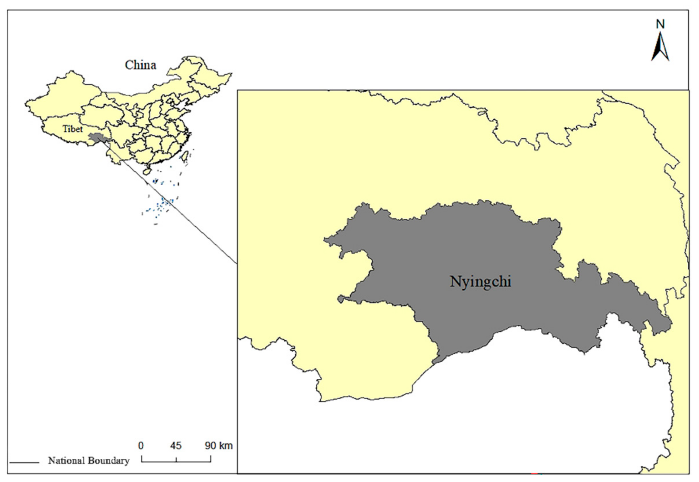
3.1. Study Area

Nyingchi is located in the southeast of the Tibet Autonomous Region which possesses rich tourist, water, and heat resources (Figure 1). However, it is mountainous with the Yarlung Zangbo River running from west to east, with the average altitude of Nyingchi being 3100 m. Meanwhile, the trumpet-shaped river valley topography allows the warm and humid airflow to flow from the north Indian Ocean to the Tibetan area, bringing a special plateau temperate semi-humid monsoon climate to Nyingchi [36]. Furthermore, it has world-class tourism landscapes, such as Basom Tso and Yarlung Tsangpo Grand Canyon. Since 2010, tourism has stepped into a golden era and become the economic cornerstone in Nyingchi. However, due to its terrain and traffic conditions, it is of great significance to regional tourism development.

3.2. Data Sources

3.2.1. Economic and Social Data

The 2010–2020 economy data (Table 1), population data (Table 2), and administrative divisions data (Table 3), including industry output, population, and administrative divisions of the sub-county (district), were obtained from the Nyingchi Statistical Yearbook (2021) and Tibet Statistical Yearbook (2021). The Nyingchi Statistical Yearbook (2021) was obtained from the Nyingchi City Statistics Bureau platform (http://www.linzhi.gov.cn/tjj/c103534/202211/8b9c2d5ab1a240b185e761d04cbdb961.html) (accessed on 10 February 2022) and the Tibet Statistical Yearbook was obtained from the Tibet Statistics Bureau platform (http://tjj.xizang.gov.cn/xxgk/tjxx/tjgb/) (accessed on 10 February 2022).

3.2.2. Tourist Attraction Data

The tourist attraction data originated from the 2020 statistical bulletin published by the Nyingchi Bureau of Statistics (Table 4). The POI data of the tourist attraction for this study were obtained from the related tourism platform (https://www.ctrip.com/, https://www.qunar.com/, and https://www.dianping.com/) with the network data crawling technologies (accessed on 10 February 2022), with a total of 85 valid POI data obtained.

3.2.3. Land Traffic Data

The road and traffic network data were from OpenStreetMap and modified with the latest satellite image data, with the ArcGIS10.5 was used for spatial statistics and analysis (Table 5). The spatio-temporal distance data between nodes of different types were obtained by comprehensive statistics of navigation functions, such as Baidu Maps, Amap, and the open access platform (https://xizang.tianditu.gov.cn/) (accessed on 10 February 2022).

4. Methodology

4.1. The Measurement of Accessibility

The time (min) spent per 1 km of raster traveled is used to measure the time cost of passage. The formula is [40]:
Tcost = c × 60 v × 1000
where Tcost is the cost of travel time (min); c is the side length of the grid cell (m), taken as 1000 m; and v is the speed of travel (km·h−1). Considering that the railroad traffic has a certain closed nature, buffer zones are established along the railroad and highway with a correspondingly high pass time cost value, with the buffer zones interrupted at the railroad station to interconnect the railroad network with the surrounding roads.
Roads in the region include national roads, provincial roads, county roads, town roads, village roads, and airport expressways. According to the road design speed stipulated in the “Technical Standards for Highway Engineering of the People’s Republic of China” (JTG B01-2014), the travel speed of the road network of different grades is assigned (Table 6).
The Sichuan–Tibet Railway in Nyingchi includes Lalin Railway, which was completed in June 2021, and Yalin Railway, which is expected to be completed in 2030. The Lalin Railway is a single-line design grade I railroad, with a design speed of 160 km/h. Yalin Railway is a double-track design grade I railway, with a design speed of 200 km/h.
To measure the accessibility of tourist attractions in Nyingchi, accessibility is used as an evaluation index to reflect the accessibility of tourist attractions (Figure 2) and is calculated as follows:
A ij = j n T ij n
A ij represents the accessibility value (hours); i and j represent the tourist attractions in Nyingchi; T ij is the shortest time for spot i to reach spot j through the traffic network; and n is the total number of tourist attractions in the region except for i. The smaller the value of accessibility, the smaller the time cost of the tourist attractions to other tourist attractions and the better the accessibility of the tourist attractions; otherwise, the worse the accessibility is.

4.2. The Construction of Multi-Core Circle Theory

V. Smith extended Friedman’s “core-edge theory” to the study of tourism areas, arguing that tourism areas consist of three parts: core areas, direct support areas, and indirect support areas, with the core tourism area as the center, and the dependence of the periphery on the central scenic area decreasing with increasing time costs. The actual itinerary route is often composed of a series of tourist attractions, and the proportion of “time spent in spatial movement” and “time spent at tourist attractions” largely affects tourists’ tourism experience. According to the idea of time geography, people not only pursue minimizing the time of spatial movement but also emphasize the effective staying time at spatial points. The time spent at major tourist attractions should be at least 2 h, the rest of the tourist attractions should be approximately 0.5 h, and the average visit time of tourists should be 8–10 h. Nyingchi is rich in the types of tourist attractions, and there are diverse route options according to different visiting times. Based on the existing route arrangement statistics, excluding the first and last two days, the average number of major tourist attractions visited in Nyingchi is 2.42 per day; therefore, when the traffic distance between tourist attractions is within 2 h, it is possible to visit 2–3 tourist attractions in the same day, which does not easily make tourists feel tired; when the traffic distance increases to 2–10 h, 1–2 tourist attractions can be visited, but most of the time has been cost in traffic; when the distance is more than 10 h, it has exceeded the average visit time of tourists, and tourists cannot visit or can only visit small roadside tourist attractions, and will feel quite tired physically and mentally (Figure 3).
Therefore, the region within 2 h is defined as a “multi-core scenic circle” and belongs to the core tourism area; with dense tourist attractions and near mutual distance, tourists can visit a lot of different tourist attractions in a short period, which has a strong driving impact on the regional economy, and the local residents can participate in tourism activities in many ways. The 2–10-h region is a “single-core scenic circle” and belongs to the indirect support belt; tourists can visit a core scenic area and the surrounding small scenic areas in a day, but spend more time on the road, and so the driving impact of this circle on the economy is decreased, while it is difficult for the local residents to directly benefit from the development of the tourism economy, but they can participate in indirectly supporting the industry of tourism activities. More than 10 h for the “adventure scenic circle” belongs to the indirect support belt, whose tourists are mostly explorers and backpackers taking a day or even more time on the road to arrive at a place that seems to be underdeveloped, or even utterly bereft of human life, and the local residents hardly benefit from tourism development. As the accessibility of scenic areas changes, the construction of high-attraction density areas and high-quality tourist attractions will become a core factor in promoting sustainable tourism development and will be directly influenced by the distribution of tourist attractions.

5. Results

5.1. Accessibility Impact to Nyingchi Tourist Attractions by Land Traffic Construction

With the continuous improvement of the land traffic network, more routes can be chosen from traffic nodes to tourist attractions, which can also reflect changes in accessibility to a certain extent. The current traffic nodes are selected from the G318 national highway transit starting and ending points, namely, Mainling Airport, Nyingchi Passenger Station, and Nang Passenger Station. The future traffic accessibility will add new national highways (G219, G559, G560) transit starting and ending points and Sichuan–Tibet Railway stations within Nyingchi (Nang Station, Mainling Station, Nyingchi Station, and Bome Station). It has been calculated that the total length of the shortest distance between the current tourist attraction and the nearest traffic node is 64,632.19 km. After the planned road network and the Sichuan–Tibet Railway are completed, it will be 44,623.96 km; the total length of the route will be reduced by 30.96%. Route selection reduces the distance and the impact on regional connections, with 43.53% of the tourist attractions changing their nearest traffic nodes and 36.47% of the tourist attractions having their nearest traffic nodes become stations along the Sichuan–Tibet Railway. Railways will play a key role in changing the traffic accessibility of tourist attractions.

5.1.1. Accessibility to Nyingchi Tourist Attractions on the OD Distance

The length of each route was computed by the OD matrix between each land traffic node and the tourist attraction. It shows that the Bayi District has the greatest accessibility to a tourist attraction within 10km, accounting for 71% of the shortest route length (Table 7 and Table 8). Moreover, the construction of Nyingchi Station on the Sichuan–Tibet Railway will further enhance the accessibility of Bayi District and consolidate its position as the traffic center of Nyingchi. Traffic accessibility improvement is positively related to the economy, which leads to the cluster of population, resources, and tourism [55]. Bayi District should focus on the urbanization of the population, tourism industries development, population attraction, and tourist destination service system improvement.
It also shows that the most significant change in traffic length between nodes is located in Bome County, which accounts for 94% of the number of tourist attractions with traffic length changes of 50 km or more (Table 7 and Table 8). At present, the road network in Bome County is relatively small, and the surrounding terrain is closed. It is only connected with the Tongmai Bridge in Bayi District, while the ring road network connecting the surrounding Medog County, Chayu County, and Gongbo’gyamda County has not been completed. In particular, the highway connected with Medog County has been destroyed and built repeatedly since the establishment of the Tibet Autonomous Region due to the low level of road network, inadequate repair technology, and frequent geological disasters. The construction of National Highway G599 will connect Medog and Bome counties, making Medog join the traffic network system with Bayi and Mainling as the core and Gongbo’gyamda, Nang, and Bome as the secondary centers. The construction of the Sichuan–Tibet Railway Bome Station fundamentally solves the traffic limitation between Bome County and the surrounding area, which will effectively drive the development of the tourism industry in the Bome area and promote the goal of realizing whole area tourism in Nyingchi.

5.1.2. Accessibility to Nyingchi Tourist Attractions on the Cost Distance

The length of each route was computed by the cost matrix between each land traffic node and the tourist attraction. It shows that Bayi District has most of the highest accessible tourist attractions (19 tourist attractions) for the current and future situation, accounting for 43.18% (Figure 4). As the administrative center of Nyingchi, Bayi District has strong regional connectivity, which meets both the advantages of dense tourist resources and abundant traffic modes. However, despite the large number of tourism resources, Bayi District lacks 4A and above-4A-level tourist attractions, which results in weak competitiveness. Faced with the prospect of increasing regional accessibility and the growing competitiveness of tourism in neighboring counties, Bayi District should focus on constructing high-grade human tourist attractions as core tourist attractions, and give full play to the unique advantages of the administrative center of Nyingchi, improving tourism reception capacity and developing greater potential as a regional tourist and commodity distribution center.
It also shows that Bome County has medium accessibility to tourist attractions (10 tourist attractions), with Bome Red House as the core having significantly enhanced accessibility, with the highest proportion of natural landscapes, as well as human landscapes and high-grade red landscapes, highlighting the excellent tourism resource heritage of Bome County (Figure 5). Among them, Bome Peach Blossom Ditch Scenic Area, which relies on the climatic advantages of the Jiangnan region of Tibet, has large-scale planting of peach trees, with the annual Peach Blossom Festival having become a net-commercial marketing product. However, the current situation of a lack of high-grade highway network, railroad, airports, and other infrastructure in Bome County means that the scale and influence of the scenic area has always been severely restricted by the traffic conditions. With the planned setting of Bome Station in the Yalin section of the Sichuan–Tibet Railway, Bome County will become the gateway to Tibet from Sichuan and Sichuan Province. In the future, the completion of the Lalin and Yalin Railway will enrich the traffic network along the route, with the increased accessibility further reducing the distance friction (Figure 5).

5.2. Tourism Impact by the Change of Accessibility

5.2.1. The Current Tourist Attractions Accessibility Modes

According to the travel speed by the road network from the tourist attractions (Table 3), the accessibility to tourist attractions in Nyingchi was computed by the spatial relationship between the road network and tourist attractions, which represents the connectivity of tourism traffic within the region (Figure 6).
At present, in terms of the “0–2 h” accessibility circle, Bayi District, as the central urban region of Nyingchi, is the geographic and geometric center of Nyingchi and also the region with the highest accessibility. Different from the traditional distribution of accessibility that decreases outwardly from the center, and due to the terrain restrictions of the high mountains and valleys, the accessible region within 2 h, the “multi-core scenic circle”, is roughly distributed along the river valleys and roads in a narrow and long shape, where the terrain is relatively low and flat and the population distribution is clustering. Moreover, there is Linla Highway from Bayi District to Gongbo’gyamda County, which is an important road connecting Nyingchi and Lhasa. To the south of Bayi District, the accessibility decreases sharply from Medog County, where it borders the Indian-occupied area, and its terrain conditions are complex. Although the dispute over sovereignty has resulted in the area not being effectively developed, it has many tourist attractions that attract many backpackers with its high-quality adventure tourism resources.
Meanwhile, in terms of the “2–7 h” accessibility circle, Nang County has not been accessible to the “single-core scenic circle” Bayi District, Bome County, and Medog County within 2 h yet, and it takes more than 4 h to travel across the region, and thus the traffic network was still poor in the region. Therefore, except for self-driving tourists, few tourist groups have added Bome and Nang County to their tourism routes, which further restricts the development of the local tourism economy.
Furthermore, in terms of the “7–10 h” accessibility circle, Zayu County, as the “single-core scenic circle”, is isolated from the surrounding areas, which means that when Zayu County is selected as a tourist destination, it often takes more than 10 h and requires an overnight drive or accommodation along the way. However, there is only a developed tourist attraction, Cibaigou National Nature Reserve, in Zayu County with no level. Therefore, these situations cannot attract a number of tourists to Zayu County as a tourist destination.

5.2.2. The Improved and Integration Accessibility Modes

The improvement of highway has little impact on the accessibility among tourism attractions within 1 h, which is because the basic roads within 1 h of the accessibility of tourism attractions have been basically repaired completed. Therefore, compared with the original roads, the number of roads within the 1-h accessibility range does not change obviously, nor do the accessibility results. Meanwhile, the impact gradually increases on the improvement of the road among tourist attractions within a 2–4-h accessibility range, in which the area is the part with the most accessibility changes. A 4-h period is also the basic time for cross-county transportation within Nyingchi, from which we can learn that the road construction can strengthen the cross-regional interaction. Furthermore, the impact gradually decreases from 4 to 10 h, which is also the limit of the range contained in the “single-core scenic circle”, and intra-regional car travel is still the ideal and the only way to travel in most areas of Nyingchi. However, as distance friction increases, the impact on accessibility decreases. By 10 h or more, the accessibility area basically no longer changes, proving that the speed limit of road travel has been reached at this time, and the improvement of the road network no longer plays a role in the change of accessibility, but the change of traffic mode, using trains, airplanes, and other means of travel, is a more convenient choice.
From the perspective of the railway improvement, the great impact is on the improvement of the railway among tourist attractions within a 2-h accessibility range, due to the speed of the railroad up to 160–200 km/h, greatly saving the time between stations. However, the Sichuan–Tibet Railway has only four passenger and freight stations in the Nyingchi region, with few stations and short distances, and the railroad fails to form a network between regions, and so the frequency and passenger flow will be limited. Meanwhile, there is almost no impact on the improvement of the railway among tourist attractions above a 4-h accessibility range, because the railway line within the Nyingchi region only passes through several central urban areas with good traffic conditions, while most remote areas are not laid out with railway lines, meaning that long-distance traffic has not been significantly changed.
From the perspective of integration of the road and railway improvement, the change of regional accessibility reaches the maximum. In particular, the regional accessibility of the Nang, Mainling, and Zayu counties is greatly enhanced (Figure 7). Moreover, the combination of road and railway also has an enhanced effect on the accessibility promotion of the more remote areas, because railroad solves the problem of distance friction when entering the city of Nyingchi, while the road collaboration solves the accessibility problem from the urban center to the remote areas. Therefore, in later road network planning, special attention should be paid to the positive growth of regional accessibility brought by the combination of different traffic infrastructure utilized.

5.3. The Impact by the Improvement and Integration of Accessibility to Tourist Attractions

5.3.1. The Resident Impact

Tourism, as the leading industry development of Nyingchi in the future, will have a great influence on the local resident [56]. As the residential areas are the basic unit for providing tourism services, they are the main body that receives tourists, absorbs employment, and develops the tourism economy. The nearer the residential areas are to the tourist attractions, the higher revenue is from tourism and the higher the growth of local residents’ income, which cultivates local tourism and drives up the living standards of people in the region [57]. Meanwhile, the local construction, management, and catering of scenic areas can shape a unique sense of place, bringing visitors an extraordinary experience. The accessibility of residential areas to tourist attractions can be expressed in terms of time, and the improvement of roads has increased the accessibility of residential areas, so that the accessibility of residential areas in all counties/districts will be less than 5 h, except for Zayu County, Medog County, and some residential areas in Bome (Figure 8).
In order to better reflect this change of accessibility, the rate of change was calculated in the number of residential areas where accessibility changed before and after the change in road traffic (Table 9). After the improvement of the traffic network, the number of residential areas formerly accessible from 0–1 h had the largest change, by 132%, with 1–2 h changing by 67%, and 2–3 h by 51%. The change in accessibility was mostly below 30% in the area with accessibility above 4 h, while the change in accessibility was below 10% in the area with accessibility above 10 h, having smallest change.
The improvement of the traffic network has had the most significant impact on the regional connectivity of the residential areas within a 2-h drive of the nearby tourist attractions, which is the extent of the settlements in the “multi-core scenic circle”. This means that residents in this area are better able to participate in the development of the tourism development of Nyingchi, having more possibilities to participate in the management and construction of the scenic area, the sale of special products, special performances, food and accommodation, and others. After the completion of the road, this part of the residential area accounts for 71%. The range of residential areas in the “single core scenic circle” is defined as being within 2–10 h travel time, and the improvement of the traffic network in this part of the area has less effect on the improvement of the regional connectivity of the residential areas, meaning that it will be more difficult for this area’s residents to gain income from the operation of tourist attractions, and that other ancillary sectors such as traffic will be a better option. After the completion of the road, this part of the residential areas accounted for 28%. The remaining 1% of residential areas are mostly located in the borderline areas, which are affected by many factors such as ecological environment, regional resource endowment, and historical evolution. These areas with poor infrastructure conditions and a poverty ratio of 19.7% are key areas for industrial and ecological poverty alleviation, which can give local people more options by means of relocation.

5.3.2. The Tourist Routes and Tourist Attractions Impact

By changing the connectivity between tourist attractions and residential areas, the improvement in traffic conditions has also changed the combination of tourist attractions, with several clusters of tourist attractions taking a high level of tourism as the core (Figure 9). On the one hand, the emergence of clusters has facilitated the cooperative development of medium- and low-level tourist attractions that lacked competitiveness, realizing the agglomeration advantages; on the other hand, medium- and low-level tourist attractions with a high cluster of tourist attractions could share the tourists who come from high-level tourist attractions, which encourage them to formulate correct strategies to seek differentiated development.
Based on the spatial location and future traffic accessibility of tourist attractions, points with nuclear density values of tourist attractions above 10 were selected as a cluster, and the standard deviation ellipse analysis is done separately to get the tourism cluster division (Figure 8), which roughly divides the tourist attractions in Nyingchi into three major clusters.
The Yajiang Canyon Cluster covers four counties (districts), namely, Bayi District, Mainling County, Medog County, and Bome County, with the 5A tourist attraction Yarlung Zangbo Grand Canyon as the core attraction, covering many A-grade tourist attractions such as Namcha Barwa, Lulang Scenic Area, Niyang Pavilion Southeast Tibetan Cultural Expo Park, and Kadinggou. The cluster covers the main traffic types in the region with excellent accessibility. The high-grade tourist attraction is dominated by the natural category, and the humanities category occupies a numerical advantage among the low-grade tourist attractions in this cluster. The Nanyigou scenic area, a high-grade tourist attraction, has no rival attractions in the vicinity; thus, it can be used to develop health tourism with a distance, but not so far to the core area, and its beautiful and relatively quiet environment. In the future, with the Grand Canyon as the core attraction of the cluster, various factors, such as a characteristic town, suburban tourism and adventure, and recreational tourism, will support and spread the spare time of tourists to created 2–3-day core tourist routes.
The Lhasa–Nyingchi Highway Cluster covers most tourist attractions in Gongbo’gyamda County and some of the tourist attractions in Bayi District. Due to the constraints of topography and other factors, the cluster of tourist attractions is relatively loose and is roughly distributed in bands along the river valley. Based on the high-grade Lhasa–Nyingchi Highway, most tourist attractions are fairly convenient. In addition to Basom Lake, which is a 5A-grade tourist attraction, all other tourist attractions are not graded, and Basom Lake is located at the edge of the cluster, having a low driving capacity for other tourist attractions. The cluster should focus on discovering the cultural content of the Ancient Tea Horse Road, enhancing the level of the old town of Taizhao and other historical sites, showing the historical traces of Tibetan cultural exchanges, and becoming a double engine with the Basom Lake to pull the tourism development of Gongbo’gyamda County.
The Lhasa–Nyingchi Railway Cluster, with Nang County as its core, is dominated by unclassified tourist attractions in the region, lacking core tourist attractions, but with a unique variety of tourism resources that allow for differentiation development. For example, the village of Chongkang, with the Chongkang Manor and a thousand-year-old walnut forest, is the hometown of the Living Buddha and the birthplace of The Guinness Book of Records for ancient trees, having an excellent natural resource. With the operation of the Lhasa–Nyingchi Railway, this cluster enters a new period of development, which can be achieved by cultivating a high-grade core tourist attraction, attracting transit passengers to the railway station, enriching the type of tourism and landscape, and driving the growth of the surrounding small scenic areas.
Besides cluster development, the goal of all-for-one tourism should be gradually realized. At this stage, the tourist attractions all appear along the main roads, except for those with special resource advantages. The popularity and the grade of other tourist attractions are strictly limited by the traffic conditions. With the enrichment of the road network, more and more unknown and excellent tourist attractions will come into the public eye, so Nyingchi should be prepared to fully improve its regional infrastructure.

6. Discussion

6.1. Advantages

The current studies on accessibility mainly focus on the more economically developed plain areas, with very few studies conducted on accessibility in mountainous areas. Research methods focus on the measurement of travel time and costs, but the terrain conditions in mountainous areas are complex and diverse, considering road speed, cost, and other factors. In addition, mountain residents are mainly engaged in traditional farming and animal husbandry, and often have no other sources of income; the development of ecotourism is sustainable for mountainous areas, involving residents in tourism activities and thus bringing positive economic benefits to their communities. Therefore, in this paper, Nyingchi was selected as a study case and accessibility evaluation methods were used to validate it, taking into account traffic and terrain factors.

6.2. Implications and Limitations

Most of the studies on the accessibility of mountain tourism focus on “traffic-tourism interaction”, the spatial pattern of accessibility, the spatial and temporal compression effect of railroads, and the impact of the backbone traffic network on tourism. In this paper, under the guidance of multi-core theory, we discuss the linkage between the mountain attractions system and the resident community system, which can effectively provide direction for local residents to participate in tourism activities. In addition, the development of ecotourism is sustainable for mountainous areas, which can generate positive economic benefits for local communities and take advantage of tourism, and then residents can perform diversified tourism activities to provide tourism economic benefits for local communities. In addition, as a frontier region, the prosperity and stability of the people in Nyingchi is related to the stability of the society, and the enhancement in the accessibility of scenic spots is also significant to stabilize and flourish the frontier.
The integration of “core-edge” regions should be realized and is often reflected in the design of tourism routes. That is, the status of world-class, national, and regional-level tourism resources should be highlighted by analyzing and comparing the objective differences of tourism resources. For example, the Yarlung Zangbo River and the Grand Canyon should be taken as the core attraction to form a number of growth poles of tourism resources. At the same time, it highlights the complementarity of resource advantages in the “core-edge” structure rather than the spatial substitution competition, and then takes the tourist traffic line as the bridge, and the tourist attractions as the nodes of the tourist routes, so as to form a regional system of tourist resources. Furthermore, the government and tourist attraction managers should pay attention to the “core-edge” tourist attraction planning. For the multi-core model, the linkage of regional tourism development first expression is “core-edge” structure within the system of tourism interaction, followed by a “core-edge” structure system with another can also occur among a tourism interaction structure system, which forms a composite structure of “core-edge” system. In general, it is an important spatial strategic measure for regional tourism development to develop the core and drive the edge. Therefore, any region should attach importance to the development of the tourism core, and rely on the core to consolidate all kinds of tourism resources in the region into a whole.
It should be pointed out that changes in the traffic infrastructure around Nyingchi may also change the accessibility of external traffic. Tourists’ choice of tourist destinations in Nyingchi is more about the attractiveness of the tourist attraction. Therefore, when the destination is determined, the impact of the traffic accessibility of the tourist attraction may not be obvious. The choice of leading industries in different settlements is not only affected by the accessibility of tourist attractions, but also related to local social culture, historical lineage, and natural conditions. More in-depth research is still needed on specific industry choices.

7. Conclusions

In summary, analysis of the density and tourist attractions, traffic accessibility of tourist attractions, and the distribution of residential areas in Nyingchi shows: (1) The changes in traffic accessibility will highlight the location advantages of some tourist attractions, and tourist attractions can be prioritized for development under the premise of similar tourist attractions. (2) The improvement of regional accessibility requires the integration of various traffic modes to exert the greatest effect. The integration network of railways and highways will bring greater accessibility improvement. With the basic road network already in existence, the construction of additional roads will have a limited impact on enhancing accessibility for short distances of less than 2 h, but will have a stronger impact on improving accessibility for medium-to-long distances of approximately 4 h. The construction of the Lhasa–Nyingchi Railway can improve the accessibility among regional sites in a short period of time, but for sites farther away, the accessibility improvement is very limited. Therefore, the transportation efficiency can be improved to the maximum when railway and highway cooperate with each other. (3) Different types of residential areas can choose different industrial development modes according to the accessibility of tourist attractions and residential areas. Local residents could participate in the management, construction, and even investment and operation of tourist attractions, and develop diversified tourism services such as accommodation, catering, and recreation. For the residents of the “single-core scenic area circle”, the development of tourism industries will support the processing and manufacturing industries, transportation, and other tourism backup industries. For the residents of the “adventure scenic circle”, they are few and mostly located in the border areas, and the bearing capacity of ecological environment in this area is weak, so it is more difficult for them to alleviate poverty in the industry, the government can focus on poverty relocation and policy preferences. (4) The group development of tourist attractions based on spatial location and accessibility can promote the positive drive between tourist attractions and achieve the goal of all-for-one tourism. The Yajiang Canyon group’s high-grade(3A, 4A, 5A) attractions are mainly natural landscape, with low-grade(A, 2A) attractions in the humanities landscape accounted for in the main. Lhasa–Nyingchi Highway group, in addition to Batsontso, are 5A-grade attractions, while the others are ungraded attractions. The Lhasa–Nyingchi Railway group area, although mainly ungraded tourist attractions, has unique tourism resources, with classification of the group to achieve differentiated development and benign cooperation among the attractions group to provide direction. This research as a whole can provide a theoretical reference for the direction of mountain tourism going forward after the traffic accessibility is upgraded, thus promote the sustainable development of mountain cities. In this paper, traffic accessibility is calculated by considering conditions with time cost and distance cost, but there is a lack of consideration of factors such as elevation and slope, which still need to be improved and enhanced.

Author Contributions

Conceptualization, J.L. and R.M.; methodology, Q.G. and J.L.; validation, L.W., M.Z., J.S. and M.L.; formal analysis, Q.G.; investigation, R.M., M.L. and W.F.; resources, J.L.; data curation, Q.G.; writing—original draft preparation, Q.G. and J.L.; writing—review and editing, J.L.; visualization, X.L.; supervision, R.M.; project administration, J.L.; funding acquisition, J.L. All authors have read and agreed to the published version of the manuscript.

Funding

This research was funded by the Second Tibetan Plateau Scientific Expedition and Research, Ministry of Science and Technology of P.R. China, grant number [2019QZKK0406].

Institutional Review Board Statement

Not applicable.

Informed Consent Statement

Not applicable.

Data Availability Statement

Not applicable.

Conflicts of Interest

The authors declare no conflict of interest.

References

  1. Su, M.M.; Wall, G. The Qinghai–Tibet railway and Tibetan tourism: Travelers’ perspectives. Tour. Manag. 2009, 30, 650–657. [Google Scholar] [CrossRef]
  2. Lee, T.H.; Jan, F. Can community-based tourism contribute to sustainable development? Evidence from residents’ perceptions of the sustainability. Tour. Manag. 2019, 70, 368–380. [Google Scholar] [CrossRef]
  3. Ma, B.; Cai, Z.; Zheng, J.; Wen, Y. Conservation, ecotourism, poverty, and income inequality—A case study of nature reserves in Qinling, China. World Dev. 2019, 115, 236–244. [Google Scholar] [CrossRef]
  4. Khanra, S.; Dhir, A.; Kaur, P. Bibliometric analysis and literature review of ecotourism: Toward sustainable development. Tour. Manag. Perspect. 2021, 37, 100777. [Google Scholar] [CrossRef]
  5. Montrasio, R.; Mattiello, S.; Zucaro, M.; Genovese, D.; Battaglini, L. The Perception of Ecosystem Services of Mountain Farming and of a Local Cheese: An Analysis for the Touristic Valorization of an Inner Alpine Area. Sustainability 2020, 12, 8017. [Google Scholar] [CrossRef]
  6. Wang, Y.; Wang, M.; Li, K.; Zhao, J. Analysis of the Relationships between Tourism Efficiency and Transport Accessibility—A Case Study in Hubei Province, China. Sustainability 2021, 13, 8649. [Google Scholar] [CrossRef]
  7. Doerr, L.; Dorn, F.; Gaebler, S.; Potrafke, N. How new airport infrastructure promotes tourism: Evidence from a synthetic control approach in German regions. Reg. Stud. 2020, 54, 1402–1412. [Google Scholar] [CrossRef] [Green Version]
  8. Kanwal, S.; Rasheed, M.I.; Pitafi, A.H.; Pitafi, A.; Ren, M. Road and transport infrastructure development and community support for tourism: The role of perceived benefits, and community satisfaction. Tour. Manag. 2020, 77, 104014. [Google Scholar] [CrossRef]
  9. Wu, C.; Zhang, N.; Xu, L. Travelers on the Railway: An Economic Growth Model of the Effects of Railway Transportation Infrastructure on Consumption and Sustainable Economic Growth. Sustainability 2021, 13, 6863. [Google Scholar] [CrossRef]
  10. Zha, J.; He, L.; Liu, Y.; Shao, Y. Evaluation on development efficiency of low-carbon tourism economy: A case study of Hubei Province, China. Socio-Econ. Plan. Sci. 2019, 66, 47–57. [Google Scholar] [CrossRef]
  11. Gunter, U.; Wöber, K. Estimating transportation-related CO2 emissions of European city tourism. J. Sustain. Tour. 2021, 30, 145–168. [Google Scholar] [CrossRef]
  12. Rehman Khan, S.A.; Qianli, D.; SongBo, W.; Zaman, K.; Zhang, Y. Travel and tourism competitiveness index: The impact of air transportation, railways transportation, travel and transport services on international inbound and outbound tourism. J. Air Transp. Manag. 2017, 58, 125–134. [Google Scholar] [CrossRef]
  13. Bošković, N.; Vujičić, M.; Ristić, L. Sustainable tourism development indicators for mountain destinations in the Republic of Serbia. Curr. Issues Tour. 2020, 23, 2766–2778. [Google Scholar] [CrossRef]
  14. Browne, D.; Regan, B.O.; Moles, R. Use of ecological footprinting to explore alternative transport policy scenarios in an Irish city-region. Transp. Res. Part D Transp. Environ. 2008, 13, 315–322. [Google Scholar] [CrossRef]
  15. Chang, Z.; Chen, J.; Li, W.; Li, X. Public transportation and the spatial inequality of urban park accessibility: New evidence from Hong Kong. Transp. Res. Part D Transp. Environ. 2019, 76, 111–122. [Google Scholar] [CrossRef]
  16. Chen, J.; Zhang, W.; Song, L.; Wang, Y. The coupling effect between economic development and the urban ecological environment in Shanghai port. Sci. Total Environ. 2022, 841, 156734. [Google Scholar] [CrossRef]
  17. Chen, Y.; Yue, W.; La Rosa, D. Which communities have better accessibility to green space? An investigation into environmental inequality using big data. Landsc. Urban Plan. 2020, 204, 103919. [Google Scholar] [CrossRef]
  18. Coloma, J.; García, M.; Wang, Y.; Monzón, A. Green Eco-Driving Effects in Non-Congested Cities. Sustainability 2018, 10, 28. [Google Scholar] [CrossRef] [Green Version]
  19. De Luca, M.; Dell Acqua, G.; Lamberti, R. High-Speed Rail Track Design Using GIS And Multi-Criteria Analysis. Procedia Soc. Behav. Sci. 2012, 54, 608–617. [Google Scholar] [CrossRef] [Green Version]
  20. Deng, F.; Fang, Y.; Xu, L.; Li, Z. Tourism, Transportation and Low-Carbon City System Coupling Coordination Degree: A Case Study in Chongqing Municipality, China. Int. J. Environ. Res. Public Health 2020, 17, 792. [Google Scholar] [CrossRef] [Green Version]
  21. Lai, P.; Hsu, Y.; Wearing, S. A social recurrentation approach to facilitating adaptive co-management in mountain destinations managed for conservation and recreation. J. Sustain. Tour. 2015, 24, 227–244. [Google Scholar] [CrossRef]
  22. Clark, C.; Nyaupane, G.P. Connecting landscape-scale ecological restoration and tourism: Stakeholder perspectives in the great plains of North America. J. Sustain. Tour. 2022, 30, 2595–2613. [Google Scholar] [CrossRef]
  23. Ioan, S. Ecological Tourism and Public Administration in Romania. Procedia Soc. Behav. Sci. 2013, 81, 235–240. [Google Scholar] [CrossRef] [Green Version]
  24. Zhan, Z.; Ali, L.; Sarwat, S.; Godil, D.I.; Dinca, G.; Anser, M.K. A step towards environmental mitigation: Do tourism, renewable energy and institutions really matter? A QARDL approach. Sci. Total Environ. 2021, 778, 146209. [Google Scholar] [CrossRef]
  25. Jeon, M.M.; Kang, M.; Desmarais, E. Residents’ Perceived Quality of Life in a Cultural-Heritage Tourism Destination. Appl. Res. Qual. Life 2016, 11, 105–123. [Google Scholar] [CrossRef]
  26. Malik, M.I.; Bhat, M.S. Sustainability of tourism development in Kashmir—Is paradise lost? Tour. Manag. Perspect. 2015, 16, 11–21. [Google Scholar] [CrossRef]
  27. Chen, S.; Xi, J.; Liu, M.; Li, T. Analysis of Complex Transportation Network and Its Tourism Utilization Potential: A Case Study of Guizhou Expressways. Complexity 2020, 2020, 1–22. [Google Scholar] [CrossRef]
  28. Shijin, W.; Jia, X.; Lanyue, Z. China’s glacier tourism: Potential evaluation and spatial planning. J. Destin. Mark. Manag. 2020, 18, 100506. [Google Scholar] [CrossRef]
  29. Yang, Y.; Mao, Z.; Tang, J. Understanding Guest Satisfaction with Urban Hotel Location. J. Travel Res. 2018, 57, 243–259. [Google Scholar] [CrossRef]
  30. Jin, S.; Yang, J.; Wang, E.; Liu, J. The influence of high-speed rail on ice–snow tourism in northeastern China. Tour. Manag. 2020, 78, 104070. [Google Scholar] [CrossRef]
  31. Tverijonaite, E.; Ólafsdóttir, R.; Thorsteinsson, T. Accessibility of protected areas and visitor behaviour: A case study from Iceland. J. Outdoor Recreat. Tour. 2018, 24, 1–10. [Google Scholar] [CrossRef]
  32. Willibald, F.; Van Strien, M.J.; Blanco, V.; Grêt-Regamey, A. Predicting outdoor recreation demand on a national scale—The case of Switzerland. Appl. Geogr. 2019, 113, 102111. [Google Scholar] [CrossRef]
  33. Chen, D.; He, Z.; Hong, X.; Ni, X.; Ma, R. Green and Low-Carbon Commuting Evaluation and Optimization of a Cross-Border Metropolitan Region by the Subway Network: The Case of Shenzhen and Hong Kong, China. Land 2022, 11, 1127. [Google Scholar] [CrossRef]
  34. Hansen, W.G. How Accessibility Shapes Land Use. J. Am. Inst. Plan. 1959, 25, 73–76. [Google Scholar] [CrossRef]
  35. Reyes-García, M.E.; Criado-García, F.; Camúñez-Ruíz, J.A.; Casado-Pérez, M. Accessibility to Cultural Tourism: The Case of the Major Museums in the City of Seville. Sustainability 2021, 13, 3432. [Google Scholar] [CrossRef]
  36. Shaw, S.L.; Fang, Z.; Lu, S.; Tao, R. Impacts of high speed rail on railroad network accessibility in China. J. Transp. Geogr. 2014, 40, 112–122. [Google Scholar] [CrossRef]
  37. Masson, S.; Petiot, R. Can the high speed rail reinforce tourism attractiveness? The case of the high speed rail between Perpignan (France) and Barcelona (Spain). Technovation 2009, 29, 611–617. [Google Scholar] [CrossRef]
  38. Michniak, D.; Więckowski, M.; Stępniak, M.; Rosik, P. The impact of selected planned motorways and expressways on the potential accessibility of the Polish-Slovak borderland with respect to tourism development. Morav. Geogr. Rep. 2015, 23, 13–20. [Google Scholar] [CrossRef] [Green Version]
  39. Stępniak, M.; Rosik, P. The role of transport and population components in change in accessibility: The influence of the distance decay parameter. Netw. Spat. Econ. 2018, 18, 291–312. [Google Scholar] [CrossRef] [Green Version]
  40. Meyer, J.; Becker, H.; Bösch, P.M.; Axhausen, K.W. Autonomous vehicles: The next jump in accessibilities? Res. Transp. Econ. 2017, 62, 80–91. [Google Scholar] [CrossRef] [Green Version]
  41. Safdar, M.; Jamal, A.; Al-Ahmadi, H.M.; Rahman, M.T.; Almoshaogeh, M. Analysis of the Influential Factors towards Adoption of Car-Sharing: A Case Study of a Megacity in a Developing Country. Sustainability 2022, 14, 2778. [Google Scholar] [CrossRef]
  42. Suau-Sanchez, P.; Voltes-Dorta, A. Drivers of airport scheduled traffic in European winter tourism areas: Infrastructure, accessibility, competition and catchment area. J. Air Transp. Manag. 2019, 81, 101723. [Google Scholar] [CrossRef]
  43. El-Geneidy, A.; Levinson, D.; Diab, E.; Boisjoly, G.; Verbich, D.; Loong, C. The cost of equity: Assessing transit accessibility and social disparity using total travel cost. Transp. Res. Part A Policy Pract. 2016, 91, 302–316. [Google Scholar] [CrossRef] [Green Version]
  44. Deboosere, R.; El-Geneidy, A. Evaluating equity and accessibility to jobs by public transport across Canada. J. Transp. Geogr. 2018, 73, 54–63. [Google Scholar] [CrossRef]
  45. Xue, C.; Ju, Y.; Li, S.; Zhou, Q. Research on the sustainable development of urban housing price based on transport accessibility: A case study of Xi’an, China. Sustainability 2020, 12, 1497. [Google Scholar] [CrossRef] [Green Version]
  46. Raza, A.; Zhong, M.; Safdar, M. Evaluating Locational Preference of Urban Activities with the Time-Dependent Accessibility Using Integrated Spatial Economic Models. Int. J. Environ. Res. Public Health 2022, 19, 8317. [Google Scholar] [CrossRef]
  47. Raza, A.; Safdar, M.; Zhong, M.; Hunt, J.D. Analyzing Spatial Location Preference of Urban Activities with Mode-Dependent Accessibility Using Integrated Land Use–Transport Models. Land 2022, 11, 1139. [Google Scholar] [CrossRef]
  48. Wang, D.; Qian, J.; Chen, T.; Zhao, M.; Zhang, Y. Influence of the high-speed rail on the spatial pattern of regional tourism–taken Beijing–Shanghai high-speed rail of China as example. Asia Pac. J. Tour. Res. 2014, 19, 890–912. [Google Scholar] [CrossRef]
  49. Hussain, I.; Wang, H.; Safdar, M.; Ho, Q.B.; Wemegah, T.D.; Noor, S. Estimation of Shipping Emissions in Developing Country: A Case Study of Mohammad Bin Qasim Port, Pakistan. Int. J. Environ. Res. Public Health 2022, 19, 11868. [Google Scholar] [CrossRef]
  50. Xia, N.; Cheng, L.; Chen, S.; Wei, X.; Zong, W.; Li, M. Accessibility based on Gravity-Radiation model and Google Maps API: A case study in Australia. J. Transp. Geogr. 2018, 72, 178–190. [Google Scholar] [CrossRef]
  51. Liu, X.; Xu, M.; Zhou, H. Analyzing the Spatio-Temporal Distribution and Network Structure of Ecotourism Flow in Zhangjiajie. Sustainability 2022, 14, 2496. [Google Scholar] [CrossRef]
  52. Domènech, A.; Gutiérrez, A. A GIS-based evaluation of the effectiveness and spatial coverage of public transport networks in tourist destinations. ISPRS Int. J. Geo-Inf. 2017, 6, 83. [Google Scholar] [CrossRef] [Green Version]
  53. Tomej, K.; Liburd, J.J. Sustainable accessibility in rural destinations: A public transport network approach. J. Sustain. Tour. 2020, 28, 222–239. [Google Scholar] [CrossRef]
  54. O’Sullivan, D.; Morrison, A.; Shearer, J. Using desktop GIS for the investigation of accessibility by public transport: An isochrone approach. Int. J. Geogr. Inf. Sci. 2000, 14, 85–104. [Google Scholar] [CrossRef]
  55. Wickramasinghe, V.; Gunathilaka, J.P.M.H.; Handaraja, H.K.E.M.; Abeysinghe, H.P.P.M.; Herath, P.M.G.D.M. Tourism Satisfaction Index (TSI) on Traffic and Non-Traffic Function in Kandy, Sri Lanka. Case Stud. Transp. Policy 2022, 10, 2263–2270. [Google Scholar] [CrossRef]
  56. Campa, J.L.; López-Lambas, M.E.; Guirao, B. High speed rail effects on tourism: Spanish empirical evidence derived from China’s modelling experience. J. Transp. Geogr. 2016, 57, 44–54. [Google Scholar] [CrossRef]
  57. Wang, D.; Niu, Y.; Qian, J. Evolution and optimization of China’s urban tourism spatial structure: A high speed rail perspective. Tour. Manag. 2018, 64, 218–232. [Google Scholar] [CrossRef]
Figure 1. Location map of Nyingchi. Note: The map is based on the standard map of the Map Technical Review Centre of the Ministry of Natural Resources of China (Number: GS (2019)4342), with no modifications to the base map. Map-making by the author.
Land 12 00361 g001
Figure 2. Framework for this study.
Land 12 00361 g002
Figure 3. The core-edge support circle of tourist attractions and residents.
Land 12 00361 g003
Figure 4. The current accessibility with traffic nodes as the core. Note: This map is based on the standard map of the Map Technical Review Centre of the Ministry of Natural Resources of China (Number: GS (2019)4342), with no modifications to the base map. Map-making by the author.
Land 12 00361 g004
Figure 5. Future accessibility with traffic nodes as the core. Note: This map is based on the standard map of the Map Technical Review Centre of the Ministry of Natural Resources of China (Number: GS (2019)4342), with no modifications to the base map. Map-making by the author.
Land 12 00361 g005
Figure 6. The current traffic accessibility with tourist attraction location as the core. Note: This map is based on the standard map of the Map Technical Review Centre of the Ministry of Natural Resources of China (Number: GS (2019)4342), with no modifications to the base map. Map-making by the author.
Land 12 00361 g006
Figure 7. Comprehensive accessibility under the condition of perfect highway and railway with tourist attractions as the core. Note: This map is based on the standard map of the Map Technical Review Centre of the Ministry of Natural Resources of China (Number: GS (2019)4342), with no modifications to the base map. Map-making by the author.
Land 12 00361 g007
Figure 8. Traffic accessibility of villages in Nyingchi: (a) before traffic change; (b) after traffic change. Note: Settlement numbers (1–80 belong to Gongbo’gyamda County; 81–177 belong to Zayu County; 178–261 belong to Bome County; 262–314 belong to Nang County; 315–382 belong to Bayi District; 383–449 belong to Mainling County; 450–504 belong to Medog County).
Land 12 00361 g008
Figure 9. Tourism group classification based on spatial location and traffic accessibility of tourist attractions. Note: The map is based on the standard map of the Map Technical Review Centre of the Ministry of Natural Resources of China (Number: GS (2019)4342), with no modifications to the base map. Map-making by the author.
Land 12 00361 g009
Table 1. Economy data of Nyingchi from 2010 to 2020 (unit: CNY billion).
Year20102011201220132014201520162017201820192020
Tourism Industry11.0513.4718.5922.6325.8832.8339.3045.4659.2272.0039.92
Primary Industry5.966.517.057.648.188.719.2510.6611.2211.7012.29
Secondary Industry16.822.1726.1129.1933.9437.8340.7550.0261.0360.8474.05
Tertiary Industry30.9332.6739.2345.0050.7457.7965.7772.6377.7699.91105.00
Total 53.6961.3572.3981.8392.86104.33115.77133.31150.01172.45191.34
Table 2. Sub-county (district) population data of Nyingchi from 2010 to 2020 (unit: person).
County20102011201220132014201520162017201820192020
Bayi District54,70256,23057,22058,01059,44760,10061,54763,11364,41665,80584,254
Gongbo’gyamda County29,92930,77031,31032,77033,62034,14034,97035,91036,48637,27232,874
Mainling County 22,83423,35023,76024,23024,91325,44026,23027,18827,87428,47526,176
Medog County10,96311,30011,50011,72011,94912,38913,07513,72514,17314,47814,889
Bome County33,48033,84034,43034,81035,59236,10336,94737,92638,60839,44034,858
Zayu County27,25527,85028,33028,73029,39329,91330,82531,39832,03932,72928,237
Nang County15,94616,46016,75017,03017,47617,81518,70618,93419,40419,82217,648
Table 3. The administrative division data of Nyingchi (unit: number).
CountrySub-DistrictTownVillage
Bayi District2769
Mainling County——868
Gongbo’gyamda County——981
Nang County——651
Bome County——1084
Zayu County——696
Medog County——845
Table 4. The distribution of tourist attractions in Nyingchi with a 3A grade and above 3A grade.
Tourist AttractionDistributionGrade
Yarlung Zangbo Grand Canyon Nature ReservePai Township, Mainling County5A
Basom TsoCuogao Township, Gongbo’gyamdaCounty 5A
Midui GlacierYupu Township, Bome County4A
Bome Red House Red Scenic AreaZamu Middle Road, Bome County4A
Lulang Lin HaiLulang Township, Bayi District4A
NanyigouNanyi Luoba Ethnic Township, Mainling County4A
Big Cypress Scenic Area Middle and lower reaches of Niyang River, Bayi District4A
Kading Tianfo Waterfall Scenic AreaBayi Township, Bayi District4A
Chongkang ManorS306 side, Nang County 3A
Gongzhong Village Ancient Ecological ParkGongzhong Village, Bayi District3A
Niyangge Tibetan Southeast Cultural Expo ParkBayi Township, Bayi District3A
Note: The grade of the tourist attraction is evaluated by classification and evaluation of the quality grade of the tourist attraction (GB/T17775-2003) and is awarded by the National Tourism Administration of the People’s Republic of China, with rankings of 1A, 2A, 3A, 4A, and 5A, from low grade to high grade.
Table 5. Traffic data types and sources.
TypeSource
Traffic dataOpenStreetMap
Spatio-temporal distance dataBaidu Maps, Amap, https://xizang.tianditu.gov.cn/
Table 6. Travel time cost of the road networks in Nyingchi.
Road GradeNational RoadProvincial RoadCounty RoadTown RoadVillage RoadExpress
Road
Speed (km/h)655040303070
Cost (min)0.921.201.502.002.000.86
Table 7. The top 10 scenic tourist attractions’ route length within 10 km from traffic nodes.
Tourist AttractionsCurrent Nearest Node Future Nearest NodeGradeType
Tsumuji Lake National Forest ParkNyingchi Passenger Transport CenterNyingchi Passenger Transport Center UngradedNatural landscape
Bome Red HouseG318 Right NodeBome Station4AHuman landscape
Nyingchi Nature MuseumNyingchi Passenger Transport CenterNyingchi Passenger Transport Center UngradedNatural landscape
Bijiksan Ecological Scenic AreaNyingchi Passenger Transport CenterNyingchi Passenger Transport Center UngradedHuman landscape
Fujian ParkNyingchi Passenger Transport CenterNyingchi Passenger Transport CenterUngradedHuman landscape
Benism Guxiu TempleNyingchi Passenger Transport Center Nyingchi StationUngradedHuman landscape
Public Village Ancient Ecological Park (Thousand Year Walnut King Folk Village)Nyingchi Passenger Transport CenterNyingchi Passenger Transport Center3AHuman landscape
Lanxian Martyrs’ CemeteryNang County Passenger TerminalNang County Passenger TerminalUngradedHuman landscape
Benjamin MountainNyingchi Passenger Transport Center Nyingchi StationUngradedNatural landscape
Yajiang Park, Nang County, TibetNang County Passenger TerminalNang County Passenger TerminalUngradedNatural landscape
Table 8. The top 10 tourist attractions’ route length reduction above 50km from traffic nodes.
Tourist AttractionsCurrent Nearest Node Future Nearest NodeLocationShortened Length (Meter)
Cibagou National Nature ReserveG318 Right NodeG559 NodeChatsumi County376,816.08
Garang Lake G318 Right NodeBome Station Bome County111,481.03
Bome Peach Blossom Gorge G318 Right Node Bome StationBome County111,479.05
Tibetan King CaveG318 Right NodeBome StationBome County109,126.55
The ruins of the Garang PalaceG318 Right NodeBome StationBome County109,066.52
Guxiang LakeG318 Right NodeBome StationBome County109,017.79
Gangxiang Nature ReserveG318 Right Node Bome StationBome County108,836.02
Bome Red House G318 Right Node Bome Station Bome County107,559.44
Gavalong G318 Right Node Bome Station Bome County79,318.42
Garong TempleG318 Right Node Bome Station Bome County79,307.83
Table 9. Resident number within different accessibility ranges before and after reconstruction.
1 h2 h3 h4 h5 h6 h7 h8 h9 h10 h11 h
Before reconstruction/number96213296361392416431442457465477
After reconstruction/number223355447459486496498499499500501
Rate of change/%132.366.751.027.124.019.215.512.99.27.55.0
12 h13 h14 h15 h16 h17 h18 h19 h20 h21 h
Before reconstruction/number493496498500501501502502502503
After reconstruction/number501501501502502503503503503503
Rate of change/%1.61.00.60.40.20.40.20.20.20.0
Disclaimer/Publisher’s Note: The statements, opinions and data contained in all publications are solely those of the individual author(s) and contributor(s) and not of MDPI and/or the editor(s). MDPI and/or the editor(s) disclaim responsibility for any injury to people or property resulting from any ideas, methods, instructions or products referred to in the content.

