A GIS-Based Kinematic Analysis for Jointed Rock Slope Stability: An Application to Himalayan Slopes
Abstract
:1. Introduction
1.1. Aim and Contributions
- (1)
- A modified kinematic analysis method is proposed to represent kinematic susceptibility based on the geometrical degree of vulnerability of a failure element, i.e., a plane or intersection within a range from 0 to 100. The modified method is more flexible than the conventional outcomes of zero or one (i.e., fail or no fail).
- (2)
- An easily implementable algorithm is proposed to perform deterministic rock slope stability analysis. The efficiency of this analysis in predicting rock block release zones is demonstrated through a case study in the mountainous regions of the Indian Himalayas. Subsequently, the results are evaluated by quantifying the association among predicted unstable zones and the inventory of released zones.
- (3)
- The capability of a slope optimisation algorithm is demonstrated to produce a layer indicating safe and unsafe slopes, which would immensely help preliminary engineering decisions on a large mountainous region.
1.2. State-of-the-Art
1.3. Kinematic Susceptibility
2. Materials and Methods
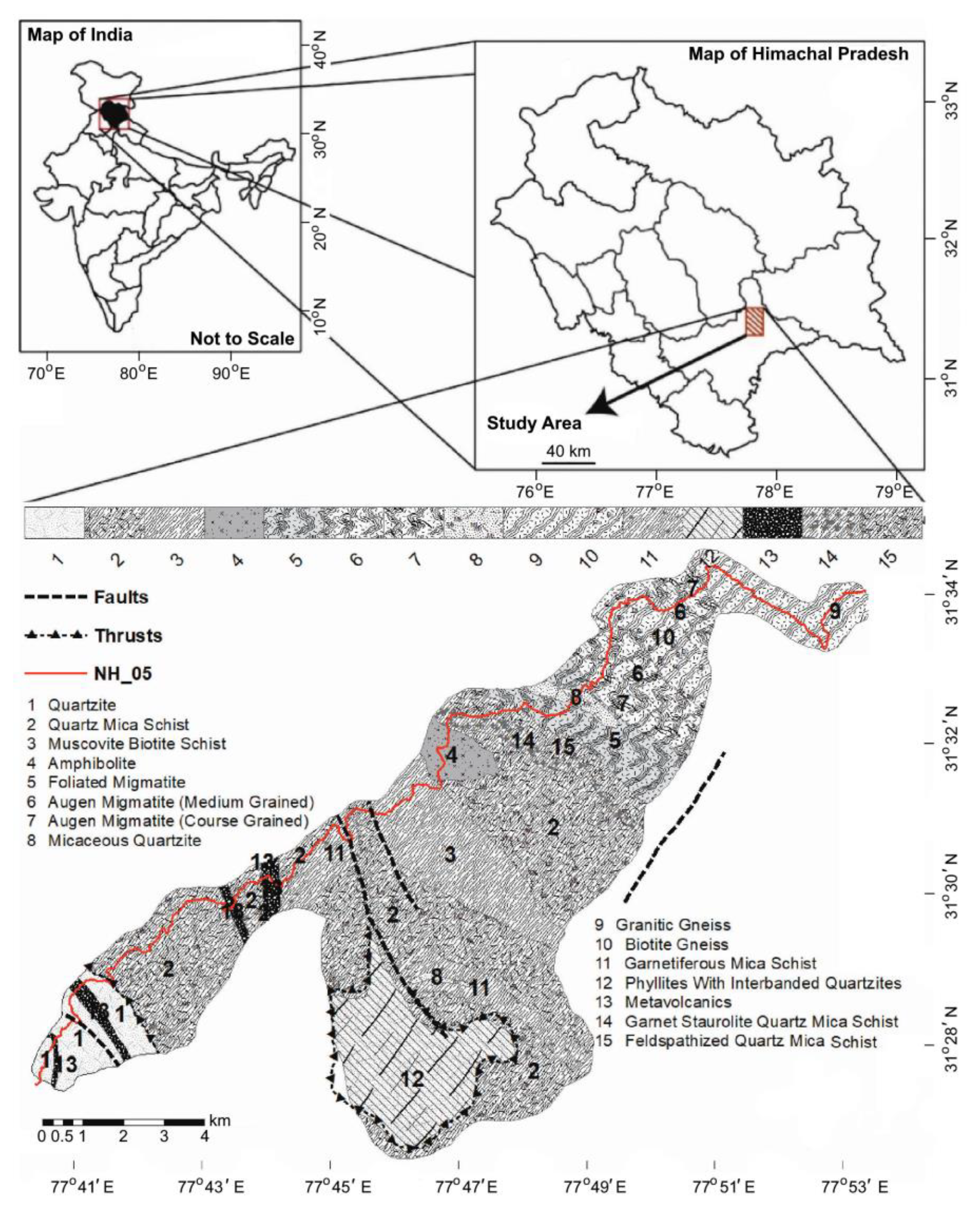
2.1. Study Area
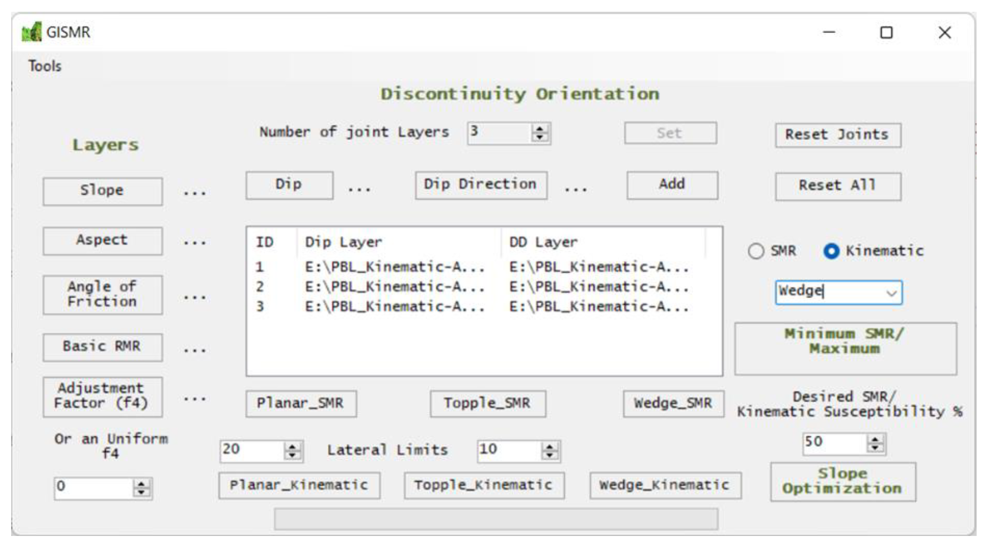
2.2. A Brief Description of GISMR
2.3. Methods for Preparation of Input Data
2.3.1. Preparation of Geo-Structural Information
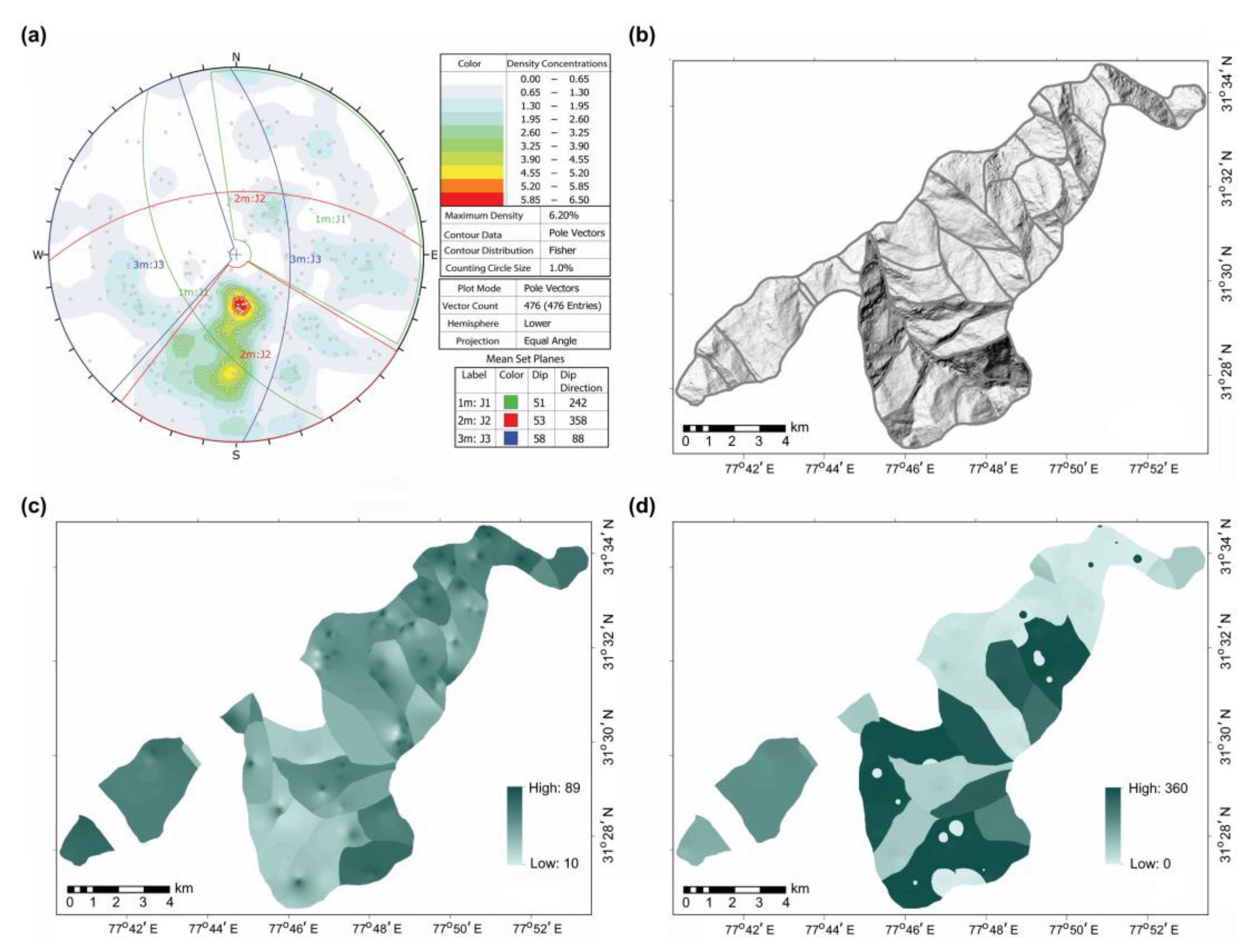
2.3.2. Defining Homogenous Structural Domains
2.3.3. Categorising Joints into Different Sets
2.3.4. Interpolation of Discontinuities
2.3.5. Topographic, Rock Mass Rating and Friction Information
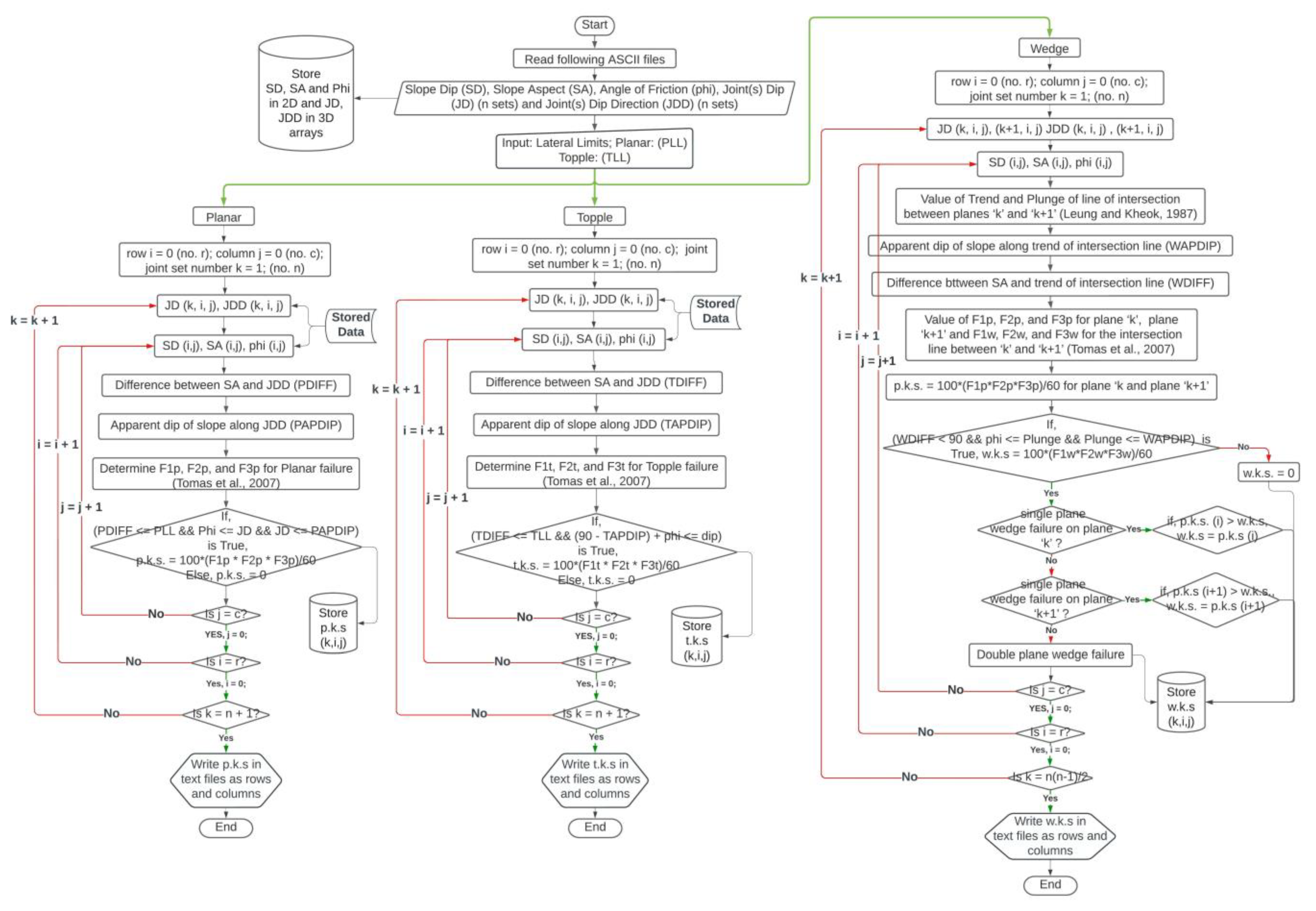
2.3.6. Input and Computation in GISMR
3. Results
4. Discussion
5. Conclusions
Author Contributions
Funding
Data Availability Statement
Acknowledgments
Conflicts of Interest
Appendix A
| Ref. Year | Brief Description | Methods and Tools | Relevance and Limitations |
|---|---|---|---|
| [20] 2000 | Presents a technique to classify the association between topography and planar geological beddings. Applied the technique at southern flank of the Santa Ynez Mountains (8.2 km2), California. | Introduces TOBIA index, which is a function of the topographic slope, aspect, bedding dip and dip direction. It uses DEM derived slope and aspect layers and Interpolated dip and dip direction of distributed bedding planes in an area. | Provides an efficient means for estimating topographic/bedding-plane intersection angles over large areas. However, it does not consider interaction of discontinuities other than bedding planes. |
| [23] 2003 | Introduced a software suite SLOPEMAP for the derivation of geometrical and kinematical properties of hill slopes in joint rock slopes. The proposed methods were tested at the Oker water reservoir, Lower Saxony, Germany. | The 2D grid based QUICKBASIC program uses 3D vector data information derived from digital structural model (DSM) and DEM for the calculations. The program package SLOPEMAP consists of tools like DIRCOS, EDGEMAP, ANGMAP, WEDGEFAIL, STRESSMAP and requires application of one or more tools based on the analysis type. | The method and tools are Ideal for regional slope stability assessment. Only ANGMAP and WEDGEFAIL are available as extensions at open-source SAGA-GIS. Missing components of the suite from public platform makes it difficult to use. |
| [24] 2007 | Introduced a fuzzified method for digital kinematic analysis of jointed rock slope. The method was applied and assessed for an area in Ankara, Turkey. The analysis considered all measured discontinuities in the studied area for Planar, wedge and topple failure. | The method works by obtaining the potential instability index (PII) based on the number of possible instability events for each failure type and then normalizing and fuzzifying the PII value for each failure type at each pixel. It developed a Qbasic computer program named FUDIKA (Fuzzified Digital Kinematic Analyses) to implement the methods. | The program considers the effect of less frequent joints to produce a more reliable fuzzified output. However, the spatially distribution of discontinuities were not considered in the analysis. The program FUDIKA is not publicly available. |
| [25] 2015 | The authors present a GIS-based method to extract information on bedding planes from the analysis of information captured through the visual interpretation of stereoscopic aerial photographs and a digital representation of the terrain. | The work determines bedding attitudes starting from a layer of bedding trace and DEM. Interpolates point bedding measurements over a region to produce a morpho structural map and calculates the bedding attitude—slope relationships based on the TOBIA index. The article provides two scripts for the GRASS GIS software environment (version 7). | Allows determination of structural information in inaccessible areas in a time effective manner. Collecting bedding attitude information from aerial Photographs limits collecting data in landslide-bearing areas. The work does not consider the effect of structural joints other than the beddings. |
| [26] 2016 | The work employs grid based probabilistic method on a GIS-based kinematic analysis to incorporate variability in the discontinuity orientation. It was applied to spatially distributed steep rock slopes along a tortuous mountain road in the Baehuryeong area, Korea. | GIS-based kinematic analysis was performed on a cell-by-cell basis using a pixel size of 2 m. A probabilistic approach using Monte Carlo simulation for discontinuities was used to consider the variability in orientation. A probability of Kinematic instability of 20% was considered as the criterion for an unstable slope condition. | Though the method considers orientation variability, it neglects the spatial variability of discontinuities. Same joint sets and orientation value was considered for a long stretch of the region. In addition, the possibility of topple failure was not considered. |
| [81] 2022 | The authors developed a user-friendly GIS extension tool, namely GIS-FORM landslide prediction toolbox, applied to landslide susceptibility analysis in Sichuan Province, China. | The FORM toolbox has four parts: (1) generating files for geospatial dataset, (2) choosing model, (3) implementing the computation according to ArcPy, and (4) creating hazard assessment maps. The tool considers uncertainties in landslide susceptibility analysis. | The toolbox can rigorously consider the statistical information of uncertain parameters for landslide prediction, but it is not suitable for rainfall-induced landslide predictions. |
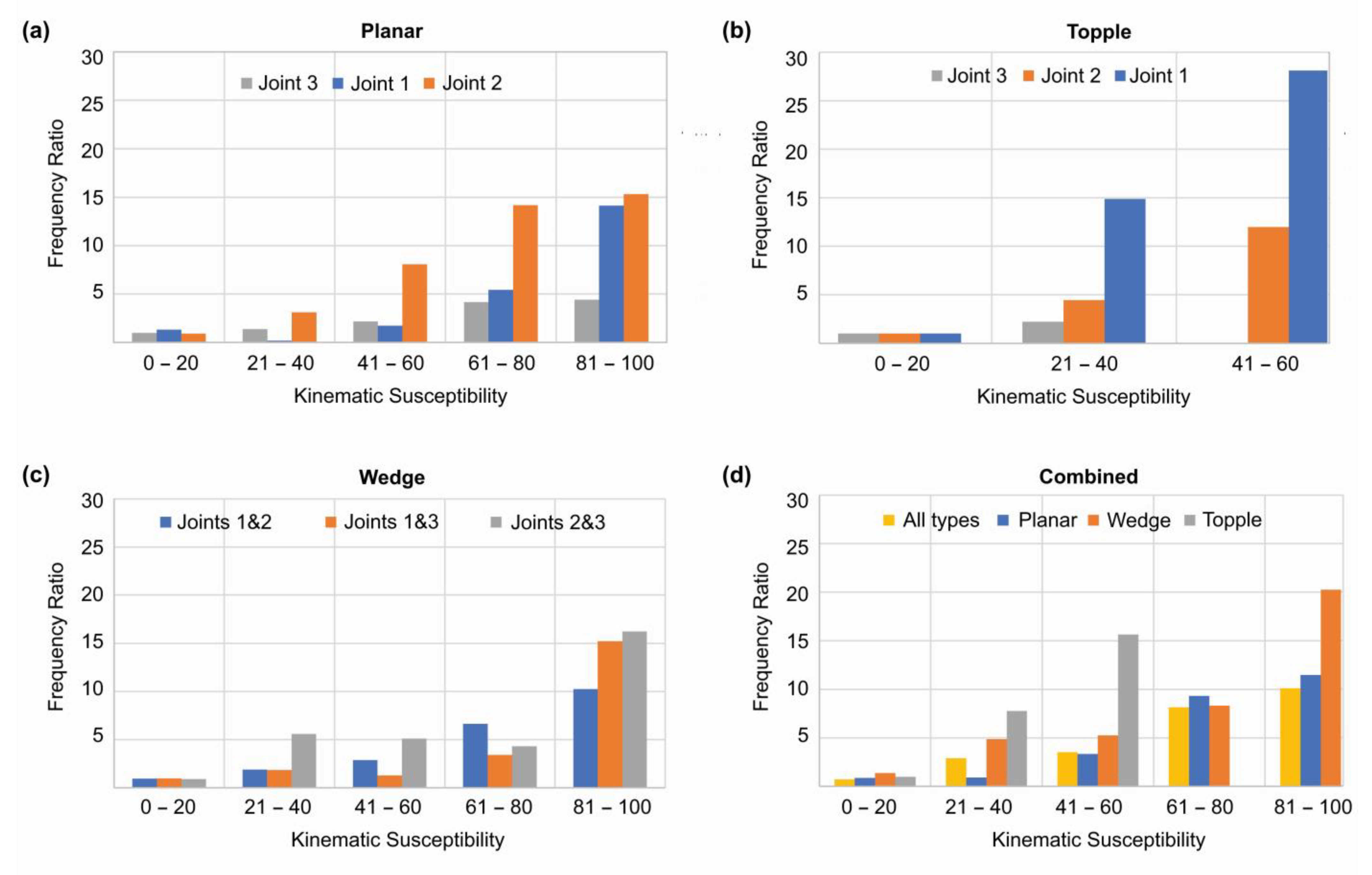
| Susceptibility Range | Pixels Susceptible to Planar Failure (|% of Total Pixels) | Pixels Susceptible to Topple Failure (|% of Total Pixels) | |||||||||||||||
| Joint 1 | Joint 2 | Joint 3 | All Joint Sets | Joint 1 | Joint 2 | Joint 3 | All Joint Sets | ||||||||||
| 0–20 | 61 | 0.01 | 9 | 0.00 | 7 | 0.00 | 77 | 0.01 | 3896 | 0.60 | 6795 | 1.04 | 2421 | 0.37 | 13,112 | 2.02 | |
| 21–40 | 3158 | 0.49 | 575 | 0.09 | 1374 | 0.21 | 5102 | 0.78 | 581 | 0.09 | 1333 | 0.20 | 116 | 0.02 | 2030 | 0.31 | |
| 41–60 | 4455 | 0.69 | 1889 | 0.29 | 4588 | 0.71 | 10,869 | 1.67 | 32 | 0.00 | 264 | 0.04 | 3 | 0.00 | 299 | 0.05 | |
| 61–80 | 1245 | 0.19 | 2280 | 0.35 | 2722 | 0.42 | 6215 | 0.96 | — | — | — | — | — | — | — | — | |
| 81–100 | 207 | 0.03 | 682 | 0.10 | 740 | 0.11 | 1628 | 0.25 | — | — | — | — | — | — | — | — | |
| failed | 9126 | 1.40 | 5435 | 0.84 | 9431 | 1.45 | 23,891 | 3.67 | 4509 | 0.69 | 8392 | 1.29 | 2540 | 0.39 | 15,441 | 2.37 | |
| stable | 641,185 | 98.60 | 644,876 | 99.16 | 640,880 | 98.55 | 626,420 | 96.33 | 645,802 | 99.31 | 641,919 | 98.71 | 647,771 | 99.61 | 634,870 | 97.63 | |
| Susceptibility Range | Pixels Susceptible to Wedge Failure (|% of Total Pixels) | Combined Types of Failure | Planar to All Mode % | Topple to All Mode % | Wedge to All Mode % | ||||||||||||
| Joint 1&2 | Joint 1&3 | Joint 2&3 | All Intersections | All Failure | % of Total Pixels | ||||||||||||
| 0–20 | 2479 | 0.38 | 2525 | 0.39 | 4307 | 0.66 | 7491 | 1.15 | 16,804 | 2.58 | 0.46 | 78.03 | 44.58 | ||||
| 21–40 | 2750 | 0.42 | 3867 | 0.59 | 3909 | 0.60 | 8648 | 1.33 | 14,844 | 2.28 | 34.37 | 13.68 | 58.26 | ||||
| 41–60 | 1895 | 0.29 | 2956 | 0.45 | 3595 | 0.55 | 7213 | 1.11 | 18,100 | 2.78 | 60.05 | 1.65 | 39.85 | ||||
| 61–80 | 1420 | 0.22 | 863 | 0.13 | 1440 | 0.22 | 3522 | 0.54 | 9720 | 1.49 | 63.94 | — | 36.23 | ||||
| 81–100 | 860 | 0.13 | 195 | 0.03 | 330 | 0.05 | 1380 | 0.21 | 3007 | 0.46 | 54.14 | — | 45.89 | ||||
| failed | 9404 | 1.45 | 10,406 | 1.60 | 13,581 | 2.09 | 28,254 | 4.34 | 62,475 | 9.61 | 38.24 | 24.72 | 45.22 | ||||
| stable | 640,907 | 98.55 | 639,905 | 98.40 | 636,730 | 97.91 | 622,057 | 95.66 | 587,836 | 90.39 | Total number of pixels = 650,311 | ||||||
References
- Rechberger, C.; Fey, C.; Zangerl, C. Structural characterisation, internal deformation, and kinematics of an active deep-seated rockslide in a valley glacier retreat area. Eng. Geol. 2021, 286, 106048. [Google Scholar] [CrossRef]
- Cruden, D.M.; Hu, X.Q. Exhaustion and steady state models for predicting landslide hazards in the Canadian Rocky Mountains. Geomorphology 1993, 8, 279–285. [Google Scholar] [CrossRef]
- Agliardi, F.; Crosta, G.; Zanchi, A. Structural constraints on deep-seated slope deformation kinematics. Eng. Geol. 2001, 59, 83–102. [Google Scholar] [CrossRef]
- Grelle, G.; Revellino, P.; Donnarumma, A.; Guadagno, F.M. Bedding control on landslides: A methodological approach for computer-aided mapping analysis. Nat. Hazards Earth Syst. Sci. 2011, 11, 1395–1409. [Google Scholar] [CrossRef]
- Travelletti, J.; Malet, J.P.; Samyn, K.; Grandjean, G.; Jaboyedoff, M. Control of landslide retrogression by discontinuities: Evidence by the integration of airborne- and ground-based geophysical information. Landslides 2013, 10, 37–54. [Google Scholar] [CrossRef]
- Břežný, M.; Pánek, T. Deep-seated landslides affecting monoclinal flysch morphostructure: Evaluation of LiDAR-derived topography of the highest range of the Czech Carpathians. Geomorphology 2017, 285, 44–57. [Google Scholar] [CrossRef]
- Gupta, V.; Solanki, A.; Jagtap, S.; Joshi, M.; Bhakuni, S.S. Morpho-structural approach to assess landslides in the Kali river valley, NE Kumaun Himalaya, India. Environ. Earth Sci. 2022, 81, 35. [Google Scholar] [CrossRef]
- Cruden, D.M.; Eaton, T.M. Reconnaissance of rockslide hazards in Kananaskis Country, Alberta. Can. Geotech. J. 1987, 24, 414–429. [Google Scholar] [CrossRef]
- Goodman, R.E.; Bray, J.W. Toppling of rock slopes. In Proceedings of the Specialty Conference on Rock Engineering for Foundations and Slopes, Boulder, CO, USA, 15–18 August 1976; Volume 2, pp. 201–223. [Google Scholar]
- Hoek, E.; Bray, J.W. Rock Slope Engineering, 3rd ed.; The Institution of Mining and Metallurgy: London, UK, 1981; pp. 341–351. [Google Scholar]
- Matheson, G.D. Rock Stability Assessment in Preliminary Site Investigations—Graphical Methods; Report 1039; Transport and Road Research Laboratory: Crownthorne, UK, 1983. [Google Scholar]
- Kundu, J.; Sarkar, K.; Singh, A.K. Integrating structural and numerical solutions for road cut slope stability analysis: A case study, India. In Rock Dynamics: From Research to Engineering; CRC Press: Boca Raton, FL, USA, 2016; pp. 457–462. [Google Scholar] [CrossRef]
- Cundall, P.A.; Hart, R.D. Numerical modelling of discontinua. Eng. Comput. 1992, 9, 101–113. [Google Scholar] [CrossRef]
- Hammah, R.; Yacoub, T.; Corkum, B. The practical modelling of discontinuous rock masses with finite element analysis. In 42nd US Rock Mechanics Symposium and 2nd U.S.-Canada Rock Mechanics Symposium; American Rock Mechanic Association, Curran Associates, Inc.: Red Hook, NY, USA, 2008; pp. 56–63. [Google Scholar]
- Kundu, J.; Mahanta, B.; Tripathy, A.; Sarkar, K.; Singh, T.N. Stability Evaluation of Jointed Rock Slope with Curved Face. INDOROCK-2016. In Proceedings of the 6th Indian Rock Conference June 17-18 IIT Bombay, Jointly Organized by Indian Institute of Technology Mumbai and Indian Society of Rock Mechanics and Tunneling Technology, Mumbai, India, 17–18 June 2016; pp. 971–978. [Google Scholar]
- Siad, L.; Megueddem, M. Stability analysis of jointed rock slope. Mech. Res. Commun. 1998, 25, 661–670. [Google Scholar] [CrossRef]
- Jaboyedoff, M.; Choffet, M.; Derron, M.H.; Horton, P.; Loye, A.; Longchamp, C.; Mazotti, B.; Michoud, C.; Pedrazzini, A. Preliminary slope mass movement susceptibility mapping using DEM and lidar DEM. In Terrigenous Mass Movements: Detection, Modelling, Early Warning and Mitigation Using Geoinformation Technology; Springer: Berlin/Heidelberg, Germany, 2012; Volume 9783642254956, pp. 109–170. [Google Scholar] [CrossRef]
- Romstad, B.; Harbitz, C.B.; Domaas, U. A GIS method for assessment of rock slide tsunami hazard in all Norwegian lakes and reservoirs. Hazards Earth Syst. Sci. 2009, 9, 353–364. Available online: www.nat-hazards-earth-syst-sci.net/9/353/2009/ (accessed on 10 January 2023). [CrossRef]
- Terzaghi, R.D. Sources of error in joint surveys. Géotechnique 1965, 15, 287–304. [Google Scholar] [CrossRef]
- Meentemeyer, R.K.; Moody, A. Automated mapping of conformity between topographic and geological surfaces. Comput. Geosci. 2000, 26, 815–829. [Google Scholar] [CrossRef]
- Mishra, B.K.; Bhattacharjee, D.; Chattopadhyay, A.; Prusty, G. Tectonic and lithologic control over landslide activity within the Larji–Kullu Tectonic Window in the Higher Himalayas of India. Nat. Hazards 2018, 92, 673–697. [Google Scholar] [CrossRef]
- Šilhán, K.; Pánek, T.; Škarpich, V.; Břežný, M.; Chalupa, V. Specifics of slope movements on slopes with contrasting structural conditions: Evidence from tree-ring records. Geomorphology 2022, 415, 108425. [Google Scholar] [CrossRef]
- Günther, A. SLOPEMAP: Programs for automated mapping of geometrical and kinematical properties of hard rock hill slopes. Comput. Geosci. 2003, 29, 865–875. [Google Scholar] [CrossRef]
- Aksoy, H.; Ercanoglu, M. Fuzzified kinematic analysis of discontinuity-controlled rock slope instabilities. Eng. Geol. 2007, 89, 206–219. [Google Scholar] [CrossRef]
- Santangelo, M.; Marchesini, I.; Cardinali, M.; Fiorucci, F.; Rossi, M.; Bucci, F.; Guzzetti, F. A method for the assessment of the influence of bedding on landslide abundance and types. Landslides 2015, 12, 295–309. [Google Scholar] [CrossRef]
- Park, H.J.; Lee, J.H.; Kim, K.M.; Um, J.G. Assessment of rock slope stability using GIS-based probabilistic kinematic analysis. Eng. Geol. 2016, 203, 56–69. [Google Scholar] [CrossRef]
- Park, H.J.; West, T.R. Development of a probabilistic approach for rock wedge failure. Eng. Geol. 2001, 59, 233–251. [Google Scholar] [CrossRef]
- Yoon, W.S.; Jeong, U.J.; Kim, J.H. Kinematic analysis for sliding failure of multi-facedrock slopes. Eng. Geol. 2002, 67, 51–61. [Google Scholar] [CrossRef]
- Singh, D.; Singh, P.K.; Kainthola, A.; Pandey, H.K.; Kumar, S.; Singh, T.N. Analysis of failure pattern in cut slopes of bedded sandstone: A case study. Environ. Earth Sci. 2022, 81, 398. [Google Scholar] [CrossRef]
- Admassu, Y.; Shakoor, A. DIPANALYST: A computer program for quantitative kinematic analysis of rock slope failures. Comput. Geosci. 2013, 54, 196–202. [Google Scholar] [CrossRef]
- Kundu, J.; Sarkar, K.; Verma, A.K.; Singh, T.N. Novel methods for quantitative analysis of kinematic stability and slope mass rating in jointed rock slopes with the aid of a new computer application. Bull. Eng. Geol. Environ. 2022, 81, 29. [Google Scholar] [CrossRef]
- Smith, J.V. A method for assessing discontinuity poles for potential wedge sliding. Eng. Geol. 2016, 202, 55–61. [Google Scholar] [CrossRef]
- Zheng, J.; Lü, Q.; Deng, J.; Yang, X.; Fan, X.; Ding, Z. A modified stereographic projection approach and a free software tool for kinematic analysis of rock slope toppling failures. Bull. Eng. Geol. Environ. 2019, 78, 4757–4769. [Google Scholar] [CrossRef]
- Tatone, B.S.A.; Grasselli, G. ROCKTOPPLE: A spreadsheet-based program for probabilistic block-toppling analysis. Comput. Geosci. 2010, 36, 98–114. [Google Scholar] [CrossRef]
- Zheng, J.; Kulatilake, P.H.S.W.; Asce, F.; Shu, B. Improved Probabilistic Kinematic Analysis Procedure Based on Finite Size Discontinuities and Its Application to a Rock Slope at Open Pit Mine in U.S. Int. J. Geomech. 2016, 17, 04016052. [Google Scholar] [CrossRef]
- Zhou, X.; Chen, J.; Chen, Y.; Song, S.; Shi, M.; Zhan, J. Bayesian-based probabilistic kinematic analysis of discontinuity-controlled rock slope instabilities. Bull. Eng. Geol. Environ. 2017, 76, 1249–1262. [Google Scholar] [CrossRef]
- Obregon, C.; Mitri, H. Probabilistic approach for open pit bench slope stability analysis—A mine case study. Int. J. Min. Sci. Technol. 2019, 29, 629–640. [Google Scholar] [CrossRef]
- Yan, J.; Chen, J.; Li, Y.; Li, Z.; Zhang, Y.; Zhou, X.; Mehmood, Q.; Liu, J.; Wang, Z. Kinematic-based failure angle analysis for discontinuity-controlled rock slope instabilities: A case study of Ren Yi Peak Cluster in Fusong County, China. Nat. Hazards 2022, 111, 2281–2296. [Google Scholar] [CrossRef]
- Rusydy, I.; Mulkal, M.; Baramsyah, H.; Ahmadian, H.; Hussin, H.; Al-Huda, N.; Marwan, M. Rock slope kinematic analysis for planar failure: A probabilistic approach. E3S Web Conf. 2022, 340, 01017. [Google Scholar] [CrossRef]
- Genevois, R.; Romeo, R.W.; Scarascia Mugnozza, G. Un approccio probabilistico all’analisi di stabilita di versanti in roccia. Geol. Rom. 1987, 26, 263–286. [Google Scholar]
- Ismail, A.; Ahmad Safuan, A.R.; Sa’ari, R.; Wahid Rasib, A.; Mustaffar, M.; Asnida Abdullah, R.; Kassim, A.; Mohd Yusof, N.; Abd Rahaman, N.; Kalatehjari, R. Application of combined terrestrial laser scanning and unmanned aerial vehicle digital photogrammetry method in high rock slope stability analysis: A case study. Meas. J. Int. Meas. Confed. 2022, 195, 111161. [Google Scholar] [CrossRef]
- Leung, C.F.; Kheok, S.C. Computer Aided Analysis of Rock Slope Stability. Rock Mech. Rock Eng. 1987, 20, 111–122. [Google Scholar] [CrossRef]
- Bonham-Carter, G.F. Geographic Information Systems for Geoscientists: Modelling with GIS; Pergamon, Elsevier Ltd.: Amsterdam, The Netherlands, 1994; p. 398. [Google Scholar] [CrossRef]
- Chorowicz, J.; Breard, J.Y.; Guillande, R.; Morasse, C.R.; Prudon, D.; Rudant, J.P. Dip and strike measured systematically on digitised three-dimensional geological maps. Photogramm. Eng. Remote Sens. 1991, 57, 431–436. [Google Scholar]
- Chorowicz, J.; Parrot, J.F.; Taud, H.; Hakdaoui, H.; Rudant, J.P.; Rouis, T. Automated pattern-recognition of geomorphic features from DEMS and satellite images. Z. Fur Geomorphol. 1995, 101, 69–84. [Google Scholar]
- Pack, R.T.; Tarboton, D.G.; Goodwin, C.N. The SINMAP Approach to Terrain Stability Mapping. In Proceedings of the 8th Congress of the International Association of Engineering Geology, Vancouver, BC, Canada, 21–25 September 1998; Volume 2, pp. 1157–1166. [Google Scholar]
- de Kemp, E.A. Three-dimensional projection of curvilinear geological features through direction cosine interpolation of structural field observations. Comput. Geosci. 1998, 24, 269–284. [Google Scholar] [CrossRef]
- de Kemp, E.A. Visualisation of complex geological structures using 3-D Bezier construction tools. Comput. Geosci. 1999, 25, 581–597. [Google Scholar] [CrossRef]
- Gunther, A.; Carstensen, A.; Pohl, W. Automated sliding susceptibility mapping of rock slopes. Nat. Hazards Earth Syst. Sci. 2004, 4, 95–102. [Google Scholar] [CrossRef]
- Günther, A.; Wienhöfer, J.; Konietzky, H. Automated mapping of rock slope geometry, kinematics and stability with RSS-GIS. Nat. Hazards 2012, 61, 29–49. [Google Scholar] [CrossRef]
- Ghosh, S.; Günther, A.; Carranza, E.J.M.; van Westen, C.J.; Jetten, V.G. Rock slope instability assessment using spatially distributed structural orientation data in Darjeeling Himalaya (India). Earth Surf. Process. Landf. 2010, 35, 1773–1792. [Google Scholar] [CrossRef]
- Ghosh, S.; Kumar, A.; Bora, A. Analysing the stability of a failing rock slope for suggesting suitable mitigation measure: A case study from the Theng rockslide, Sikkim Himalayas, India. Bull. Eng. Geol. Environ. 2014, 73, 931–945. [Google Scholar] [CrossRef]
- Ji, J.; Wang, C.-W.; Cui, H.-Z.; Li, X.-Y.; Song, J.; Gao, Y. A simplified nonlinear coupled Newmark displacement model with degrading yield acceleration for seismic slope stability analysis. Int. J. Numer. Anal. Methods Geomech. 2021, 45, 1303–1322. [Google Scholar] [CrossRef]
- Dadon, A.; Peeters, A.; Ben-Dor, E.; Karnieli, A. A semi-automated GIS model for extracting geological structural information from a spaceborne thematic image. GISci Remote Sens. 2011, 48, 264–279. [Google Scholar] [CrossRef]
- Matasci, B.; Stock, G.M.; Jaboyedoff, M.; Carrea, D.; Collins, B.D.; Guérin, A.; Matasci, G.; Ravanel, L. Assessing rockfall susceptibility in steep and overhanging slopes using three-dimensional analysis of failure mechanisms. Landslides 2018, 15, 859–878. [Google Scholar] [CrossRef]
- Rowe, E.; Hutchinson, D.J.; Kromer, R.A. An analysis of failure mechanism constraints on pre-failure rock block deformation using TLS and roto-translation methods. Landslides 2018, 15, 409–421. [Google Scholar] [CrossRef]
- Konstantinidis, I.; Marinos, V.; Papathanassiou, G. UAV-Based Evaluation of Rockfall Hazard in the Cultural Heritage Area of Kipinas Monastery, Greece. Appl. Sci. 2021, 11, 8946. [Google Scholar] [CrossRef]
- Menegoni, N.; Giordan, D.; Perotti, C. An Open-Source Algorithm for 3D ROck Slope Kinematic Analysis (ROKA). Appl. Sci. 2021, 11, 1698. [Google Scholar] [CrossRef]
- Gigli, G.; Lombardi, L.; Carlà, T.; Beni, T.; Casagli, N. A method for full three-dimensional kinematic analysis of steep rock walls based on high-resolution point cloud data. Int. J. Rock Mech. Min. 2022, 157, 105178. [Google Scholar] [CrossRef]
- Eberhardt, E.; Stead, D.; Coggan, J.S. Numerical analysis of initiation and progressive failure in natural rock slopes-the 1991 Randa rockslide. Int. J. Rock Mech. Min. 2004, 41, 69–87. [Google Scholar] [CrossRef]
- Leung, C.F.; Quek, S.T. Probabilistic stability analysis of excavations in jointed rock. Can. Geotech. J. 1995, 32, 397–407. [Google Scholar] [CrossRef]
- Romana, M. New adjustment ratings for application of Bieniawski classification to slopes. In Proceedings of the International Symposium on the role of rock mechanics, ISRM, Zacatecas, Mexico, 2–4 September 1985; pp. 49–53. [Google Scholar]
- Sarkar, K.; Kumar Singh, A.; Niyogi, A.; Kumar Behera, P.; Verma, A.K.; Singh, T.N. The Assessment of Slope Stability along NH-22 in Rampur-Jhakri Area, Himachal Pradesh. J. Geol. Soc. India 2016, 88, 387–393. [Google Scholar] [CrossRef]
- Siddique, T.; Masroor Alam, M.; Mondal, M.E.A.; Vishal, V. Slope mass rating and kinematic analysis of slopes along the national highway-58 near Jonk, Rishikesh, India. J. Rock Mech. Geotech. Eng. 2015, 7, 600–606. [Google Scholar] [CrossRef]
- Bieniawski, Z.T. Engineering Rock Mass Classifications: A Complete Manual for Engineering and Geologists in Mining, Civil and Petroleum Engineering; Wiley: Chichester/London, UK, 1989. [Google Scholar]
- Anbalagan, R.; Sharma, S.; Raghuvanshi, T.K. Rock mass stability evaluation using Modified SMR Approach. In Proceedings of the 6th Natural Symposium on Rock Mechanics, Bangalore, India, 15 June 1992; pp. 258–268. [Google Scholar]
- Tomás, R.; Delgado, J.; Serón, J.B. Modification of slope mass rating (SMR) by continuous functions. Int. J. Rock Mech. Min. 2007, 44, 1062–1069. [Google Scholar] [CrossRef]
- Singh, K. Deformation history of the rocks around Sarahan Bushair, Himachal Pradesh. In Structural Geology of the Himalaya; Saklani, P.S., Ed.; Today and Tomorrow’s Printers & Publishers: Darya, India, 1979; pp. 163–182. [Google Scholar]
- Pandey, A.K.; Sachan, H.K.; Virdi, N.S. Exhumation history of a shear zone constrained by microstructural and fluid inclusion techniques: An example from the Satluj valley, NW Himalaya, Indian. J. Asian Earth Sci. 2004, 23, 391–406. [Google Scholar] [CrossRef]
- Bhargava, O.N.; Kaur, G.; Deb, M. A Paleoproterozoic paleosol horizon in the Lesser Himalaya and its regional implications. J. Asian Earth Sci. 2011, 42, 1371–1380. [Google Scholar] [CrossRef]
- Mukhopadhaya, D.K.; Ghosh, T.K.; Bhadra, B.K.; Srivastava, D.C. Structural and metamorphic evolution of the rocks of the Jutogh Group, Chur half-klippe, Himachal Himalayas: A summary and comparison with the Simla area. Proc. Indian Acad. Sci.—Earth Planet. Sci. 1997, 106, 197–207, Published by Indian Academy of Sciences. [Google Scholar] [CrossRef]
- Srikantia, S.V.; Bhargava, O.N. Geology of Himachal Pradesh; Geological Society of India: Bangalore, India, 1998; pp. 1–408. [Google Scholar]
- Draganits, E.; Grasemann, B.; Janda, C.; Hager, C.; Preh, A. 300MW Baspa II—India’s largest private hydroelectric facility on top of a rock avalanche-dammed palaeo-lake (NW Himalaya): Regional geology, tectonic setting and seismicity. Eng. Geol. 2014, 169, 14–29. [Google Scholar] [CrossRef]
- Marchesini, I.; Santangelo, M.; Fiorucci, F.; Cardinali, M.; Rossi, M.; Guzzetti, F. A GIS Method for Obtaining Geologic Bedding Attitude. In Landslide Science and Practice; Margottini, C., Canuti, P., Sassa, K., Eds.; Springer: Berlin/Heidelberg, Germany, 2013. [Google Scholar] [CrossRef]
- Marchesini, I.; Santangelo, M.; Fiorucci, F.; Cardinali, M.; Rossi, M.; Bucci, F.; Guzzetti, F. TXT-tool 1.039-1.2 Bedding Attitude Information through the Interpretation of Stereoscopic Aerial Photographs and GIS Modeling. In Landslide Dynamics: ISDR-ICL Landslide Interactive Teaching Tools; Springer: Cham, Switzerland, 2018; pp. 175–186. [Google Scholar] [CrossRef]
- Msaddek, M.H.; Moumni, Y.; Chenini, I.; Dlala, M. Applicability of Developed Algorithm for Semi-automated Extraction and Morphotectonic Interpretation of Lineaments Using Remotely Sensed Data, Southwestern Tunisia. Remote Sens. Earth Sys. Sci. 2019, 2, 292–307. [Google Scholar] [CrossRef]
- Matherson, G.D. The collection and use of field discontinuity data in rock slope design. Quart J. Eng. Geol. 1989, 22, 19–30. [Google Scholar] [CrossRef]
- Wyllie, D.; Mah, C. Rock Slope Engineering; CRC Press: London, UK, 2004. [Google Scholar] [CrossRef]
- Skilodimou, H.D.; Bathrellos, G.D.; Koskeridou, E.; Soukis, K.; Rozos, D. Physical and Anthropogenic Factors Related to Landslide Activity in the Northern Peloponnese, Greece. Land 2018, 7, 85. [Google Scholar] [CrossRef]
- Karpouza, M.; Chousianitis, K.; Bathrellos, G.D.; Skilodimou, H.D.; Kaviris, G.; Antonarakou, A. Hazard zonation mapping of earthquake-induced secondary effects using spatial multi-criteria analysis. Nat. Hazards 2021, 109, 637–669. [Google Scholar] [CrossRef]
- Ji, J.; Cui, H.; Zhang, T.; Song, J.; Gao, Y. A GIS-based tool for probabilistic physical modelling and prediction of landslides: GIS-FORM landslide susceptibility analysis in seismic areas. Landslides 2022, 19, 2213–2231. [Google Scholar] [CrossRef]
- Bathrellos, G.D.; Skilodimou, H.D. Land Use Planning for Natural Hazards. Land 2019, 8, 128. [Google Scholar] [CrossRef]
- Fawcett, T. An introduction to ROC analysis. Pattern Recognit. Lett. 2006, 27, 861–874. [Google Scholar] [CrossRef]
- Conforti, M.; Ietto, F. Modeling Shallow Landslide Susceptibility and Assessment of the Relative Importance of Predisposing Factors, through a GIS-Based Statistical Analysis. Geosciences 2021, 11, 333. [Google Scholar] [CrossRef]
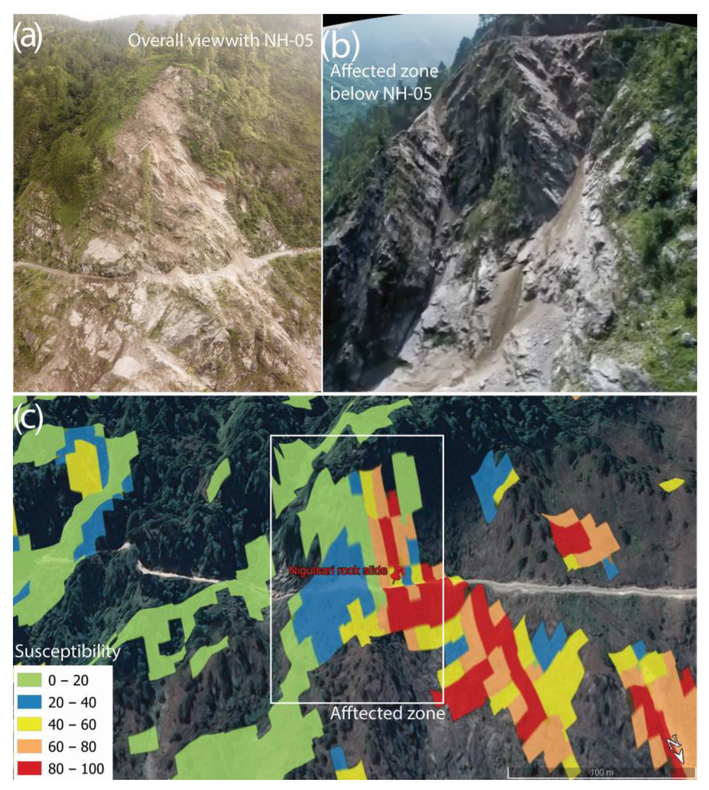
- Mohapatra, S.R.; Kohli, A.; Thakur, V.; Poonia, A. A Field Note on the Reconnaissance Study of a Rockslide Incidence of 11/08/2021 at NH-05, Near Nigulsari Village, Tehsil Nichar, District Kinnaur, Himachal Pradesh. 2021. Available online: https://employee.gsi.gov.in/cs/groups/public/documents/document/dmkx/mdm2/~edisp/dcport1gsigovi1036481.pdf (accessed on 10 January 2023).
- Nishat; Tariq, Q.A. Geological Assessment of Landslide/Slope Failure Incidence Near Jeori (Nh-05) Road, District Shimla, Himachal Pradesh. 2021. Available online: https://employee.gsi.gov.in/cs/groups/public/documents/document/dmkx/mdm2/~edisp/dcport1gsigovi1036480.pdf (accessed on 10 January 2023).
- Kundu, J. Stability Evaluation of Hill Slopes: New Perspectives to Rock Material and Rock Mass Characterisation. Ph.D. Thesis, Indian Institute of Technology (ISM), Dhanbad, India, 2020. [Google Scholar]
- Kundu, J.; Sarkar, K.; Singh, A.K.; Singh, T.N. Continuous functions and a computer application for Rock Mass Rating. Int. J. Rock Mech. Min. 2020, 129, 104280. [Google Scholar] [CrossRef]





Disclaimer/Publisher’s Note: The statements, opinions and data contained in all publications are solely those of the individual author(s) and contributor(s) and not of MDPI and/or the editor(s). MDPI and/or the editor(s) disclaim responsibility for any injury to people or property resulting from any ideas, methods, instructions or products referred to in the content. |
© 2023 by the authors. Licensee MDPI, Basel, Switzerland. This article is an open access article distributed under the terms and conditions of the Creative Commons Attribution (CC BY) license (https://creativecommons.org/licenses/by/4.0/).
Share and Cite
Kundu, J.; Sarkar, K.; Ghaderpour, E.; Scarascia Mugnozza, G.; Mazzanti, P. A GIS-Based Kinematic Analysis for Jointed Rock Slope Stability: An Application to Himalayan Slopes. Land 2023, 12, 402. https://doi.org/10.3390/land12020402
Kundu J, Sarkar K, Ghaderpour E, Scarascia Mugnozza G, Mazzanti P. A GIS-Based Kinematic Analysis for Jointed Rock Slope Stability: An Application to Himalayan Slopes. Land. 2023; 12(2):402. https://doi.org/10.3390/land12020402
Chicago/Turabian StyleKundu, Jagadish, Kripamoy Sarkar, Ebrahim Ghaderpour, Gabriele Scarascia Mugnozza, and Paolo Mazzanti. 2023. "A GIS-Based Kinematic Analysis for Jointed Rock Slope Stability: An Application to Himalayan Slopes" Land 12, no. 2: 402. https://doi.org/10.3390/land12020402
APA StyleKundu, J., Sarkar, K., Ghaderpour, E., Scarascia Mugnozza, G., & Mazzanti, P. (2023). A GIS-Based Kinematic Analysis for Jointed Rock Slope Stability: An Application to Himalayan Slopes. Land, 12(2), 402. https://doi.org/10.3390/land12020402


