Abstract
The Trevinca Massif is in the northwestern Iberian Peninsula, on the border between Galicia and Castilla-León. Its highest elevation is 2124 m at the Trevinca peak. During the Pleistocene, an extensive icefield developed in this area, occupying the flattened surfaces in the high massif zones, and generating several glacier valleys. In the occidental sector, the identified paleoglaciers reached 187 km2, and glacier tongues up to 30 km in the Bibei valley, where the ice thickness came to 527 m. The glacial forms and deposits were mapped and analyzed in the entire Trevinca massif, whereas the paleoglacial reconstruction was carried out in the occidental sector (previous works analyzed the oriental sector). The reconstruction was performed by using high-resolution orthophotography, digital elevation models with a spatial resolution of 2 m, and fieldwork surveys to identify the primary forms and estimate the ice cover in the past through the GlaRe methodology. Moreover, the paleo-ELA was estimated for this sector, and the values of the ice thickness, the ELA position, and the moraines were related to other nearest sectors to analyze their similarities and differences. Three main paleoglaciers were identified in the occidental Trevinca massif (Xares, Canda, and Bibei-Barxacova). Bibei showed the highest ice thickness and ice extension, occupying more than 140 km2 and with a thickness above 500 m some areas. Concerning the ELA, the values varied between the minimum at Xares with 1427 m and the maximum at Bibei-Barxacova with 1839 m. Four groups were identifying based on moraine ridges and were related to the different climatic phases in that sector.
1. Introduction
To understand the forms and current evolution of the different mountains of the planet, it is necessary to consider what their past was like, which means knowing what elements have shaped their landscapes. Among them, the ice masses associated with cold phases have a fundamental role in explaining the current mountain landscape and their impact on these variations [1,2,3].
Throughout history, the analysis of past glaciated landscapes has been approached from multiple perspectives. From a theoretical point of view, focused on the original glacial forms description [4] to works that focus on modeling how the dominant ice masses have been and how they have changed over time based on parameters such as their extent or depth [5], as well as the analysis of paleoenvironmental records from different perspectives and methods [6,7,8]. Accordingly, the emergence of new methodologies associated with innovative techniques has been of great importance. Currently, it is possible to date glacial remnants with great precision and estimate, through modeling methods, the surface area occupied by ice masses at different moments or climatic phases.
There have been several phases of research regarding ice surface modeling, from the first moments in which a simple mapping of the shapes was carried out to others that used new techniques to obtain 2D models [9,10]. In the last decades, the number of researchers focused on improving these studies has grown considerably. Nowadays, 3D models can be used to know the possible location of ice masses and their relevance. Among the tools designed for this task, it is relevant to mention GlaRe, a software tool proposed by Pellitero et al. [11], which was used during the development of this research.
The improvement of the techniques for obtaining 3D models and the greater precision of dating methods has led to the publication in recent decades of the results of many studies worldwide that analyze zones formerly occupied by glaciers and their evolution. In the case of the Iberian context, there are different publications in this regard [1,12], highlighting among them those dedicated to the Pyrenees area [13,14], the Cantabrian Mountains [15,16,17,18], or Sierra Nevada [19,20].
In Galicia’s case, the impact of glaciers has been crucial in the landscape’s evolution in many mountain areas and has been studied since the middle of the 20th century [21,22]. It is possible to highlight works at a global level [23] or detailed studies focused on specific mountain ranges such as the Macizo do Xistral [24], Manzaneda Massif [25,26,27,28], Serra de Ancares [29,30,31,32], Serra do Courel [33,34,35] or in the Trevinca Massif [6,36,37].
However, despite the abundance of publications, until now, a modern and comprehensive analysis has yet to be carried out on the extent and volume of glaciers in all areas affected by glaciers in Galicia. Some of the publications have focused on the reconstruction of paleotemperatures from periglacial data [7], but this has not been the case with information on glacial evidence except for the paleoglaciers in the Leonese margin of the Trevinca Massif, specifically in the sector of the Tera Valley and Sanabria lake [10,38,39]. More recently, a review of glacial geomorphology in the Galician Mountain context has been carried out on a global scale [40,41], which has contributed to identifying the different glacial phases developed in Trevinca [42].
The main objective of this study was the detailed mapping and characterization of the glacial deposits and forms present in the Trevinca Massif. From them, it was possible to carry out the paleoglacial reconstruction, estimating the volume of the glacial masses, their extension, and the values of the ELA in the western sector, which, as mentioned above, is the most unknown, as there are already previous works on the eastern part [10,38,39].
2. Study Area
The Trevinca Massif is located northwest of the Iberian Peninsula, between the autonomous communities of Galicia to the west and Castilla y León to the east (Figure 1). Topographically, it has a rounded and massive appearance, resulting from the confluence of a group of mountain ranges at a central point. These are the Serra do Eixe, which stretches from SE to NW; the Serra Calva, from NE to SW; the Serra Segundeira, from N to S; and the Sierra de la Cabrera, which stretches from W to E. The highest elevations are found in the peaks of Pena Trevinca (2127 m) and Pena Survia (2116 m), both within the Serra do Eixe.
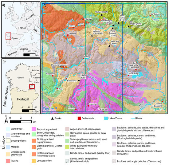
Figure 1.
Geological map of the Trevinca Massif. (a,b) represent the study sector location in the European and peninsular context; the red polygons in (a,b) indicate the frame extension in (b,c), respectively. Source of geological information: IGME (Instituto Geológico y Minero de España).
The relief of the massif must be related to the radial disposition of the rivers that flow in all directions and serve as a division between the different mountain ranges, as is the case, for example, of the Tera River that stretches from north to south and divides the Serra da Segundeira to the west from the Cabrera to the east. The fluvial network has fragmented the space generating significant topographic contrasts, as seen in Figure 1. The central sector is characterized by its horizontality and staggered elevation, which contrasts with the edges of the massif in which numerous valleys are strongly embedded. This fact is fundamental to understanding the type of glaciation developed in this area and its magnitude, as shown in Figure 2. Concerning the influence of the lithology and other factors in the glacial landforms evolution, in this sector, the structural control is more relevant than other differences such as the lithology, which is characterized by a great uniformity.
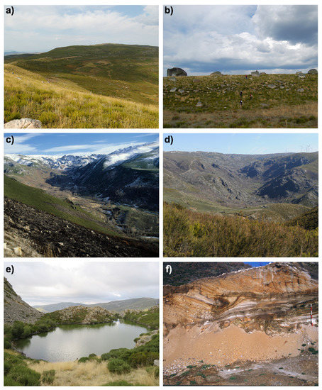
Figure 2.
Examples of glacial forms in Trevinca. (a) Moraine arches of Cepedelo; (b) detail of the upper moraine ridge of image (a); (c) glacial valley of A Ponte; (d) head of the Chanos sector; (e) A Serpe glacial lake; and (f) glacial deposits in Pías [43]. Photographs by Augusto Pérez-Alberti and Alejandro Gómez-Pazo.
In the specific case of the western sector of the Trevinca Massif, on which the paleoglacial reconstruction was focused, the analysis of the territory was carried out about the main hydrographic basins, for the case of Xares, Canda, and Bibei-Barxacova. The first is associated with the Xares river, which has its sources west of the peaks of Pena Trevinca and Pena Survia. Along its path, it merges with the valleys of Meladas, Requeixo, and Morteira. The second, Canda, is the smallest of those analyzed, stretching E–W to the south of the Serra Calva, reaching the villages of Valdín and Seoane before joining the Xares valley. On the other hand, the Bibei-Barxacova basin is the widest of those analyzed. It is hierarchized by the Bibei river that begins to flow at its headwaters following an ENE–WSW direction to progressively turn towards an N–S direction as it is joined by different valleys modeled by streams and rivers until their confluence with those of the Barxacova in the surrounding of Pías (Zamora).
Geologically, the Trevinca Massif is located in the so-called Ollo de Sapo area [25] in the context of the central Iberian zone of the Iberian Massif (Figure 1). Metamorphic rocks dominate this region with granular orthogneiss (“ollo de sapo”) and intercalations of gneiss, schist, and slate. These materials were intensely deformed and folded during the Variscan orogeny and cut by carboniferous igneous intrusions [44]. In addition to the above and to understand the current landscape of the Trevinca sector, it is necessary to mention the deformation of the Iberian microplate during the Alpine orogeny and the uplift of the crystalline basement blocks [45].
From a climatic point of view, nowadays, the conditions of the high mountains of the NW Iberian Peninsula are linked to elevation, giving rise to an oceanic mountain climate [46] with slight continental characteristics. Rainfall is high, with an annual average of 1150 ± 115 mm, and is distributed irregularly throughout the year in the form of snow during the winter [47]. For its part, the average temperature in the Trevinca environment is 8.2 ± 1.3 °C, with the average value of the maximum being 13.6 ± 1.3 °C and the minimum being 2.6 ± 1.4 °C (http://agroclimap.aemet.es, accessed on: 8 January 2023).
3. Material and Methods
The present research was based on numerous field surveys and remote office work. The fieldwork surveys were carried out over the last forty years and allowed us to locate multiple forms, deposits, and lagoons of glacial origin. In this sense, identifying moraines complexes of the different glacial phases and their precise geolocation facilitated the subsequent detailed mapping of the ice extent and confirmed the dynamics described by the 2D/3D modeling. Detailed mapping was carried out in a cabinet projection using freely available geospatial information from the National Geographic Institute of Spain (IGN), from high-resolution digital elevation models (DEM) to aerial orthophotographs. Figure 3 summarizes the workflow used, starting with the raw materials and describing the processes and tools used for the generation of the paleoglaciers and the definition of the ELA. The following sections explain these phases in detail.
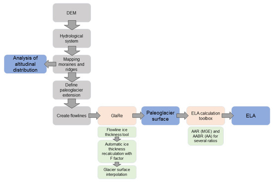
Figure 3.
Project workflow from the raw data to the results and the main tools used. Orange boxes represent the main tools, with the concrete functions in the green boxes, while the blue boxes represent the final outputs.
3.1. Mapping of Glacial Landforms and Deposits in the Trevinca Massif
The mapping section identified those elements related to a glacial origin: morainic ridges, glacial headlands and cirques, shoulder ridges, roche moutonnée, overexcavation basins, and glacial lakes. This process was developed on the whole massif. It was performed from a DEM with a spatial resolution of 2 m together with the 2017 orthophotographs from the National Aerial Orthophotography Plan (PNOA) using ArcGIS 10.8 (USC license) for the precise definition of the boundaries of glacial landforms [48] (Figure 4). Likewise, the fieldwork surveys facilitated the localization of specific landforms and delimited the search areas for the analysis by photo interpretation. This mapping was carried out at a scale of 1:2000 and through the creation of geometric elements (polygons, lines, or points) covering the extent of the shapes (Section 4.1). The result was a detailed mapping of the entire massif (Figure 5). In almost all cases, the geomorphological mapping legend of the University of Lausanne was used for the following figures [49].
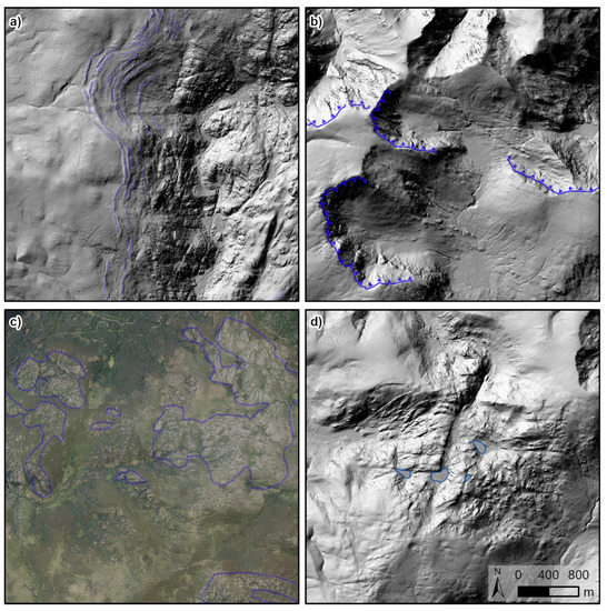
Figure 4.
Examples of glacial landforms through hill-shade DEM. (a) Moraine ridges; (b) cirque scarps; (c) roche moutonnée; and (d) glacial lakes. Source: DEM with a 2 m spatial resolution from LiDAR data (IGN).
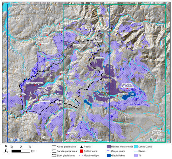
Figure 5.
Map about glacial landforms and analyzed paleobasins at the Trevinca Massif. Location in Figure 1.
3.2. The Glacial Development in the Western Sector of the Trevinca
Once all the existing forms had been mapped and given the extension of the massif, it was decided to focus the analysis on the western sector, for which, although previously analyzed, an in-depth study of the ice cover had never been carried out.
3.2.1. Distribution of Moraine Ridges
The first of the detailed analyses of the western sector of Trevinca was the distribution of the moraine ridges, which were grouped to identify different glacial phases in the absence of dating [40]. The lines drawn on each generated a point in their center, always on the line, where the elevation was recorded, which was subsequently used in the statistical processing. All the values were grouped following the Jenks method [50] and generating the main statistical parameters in R [51]. This approach developed four categories for the elevation of the moraine ridges, following previous works [40,41]. On the other hand, the ridges were also grouped according to their position in the massif context to verify the differences between the three analyzed sectors.
3.2.2. Basins/Paleobasins Delimitation
To recreate the paleoglaciers, the delimitation of the current hydrological basins was used following the steps of the ArcGIS Hydrology toolbox. These basins were used to define the paleobasins, in which the previously accumulated and mapped moraine ridges had been considered. These forms inherited from the glacial phases were primarily used for a better delimitation of the surface that could have been occupied by ice in the past. In this sense, three basins were delimited: Xares, which includes, apart from the central valley, those of the Morteira, Ponte, Couto, and Meladas rivers; the Canda basin; and the Bibei-Barxacova basin. The results section (Section 4.1 and Section 4.2) shows the extension of these paleobasins individually and the main elements present in the territory.
3.2.3. Paleoglacier Distribution and Ice Thickness
The raw data for the paleoglacial reconstruction of the selected sectors were, in this case, the DEMs of the 5 m spatial resolution of the IGN [48] and the vector layer with the moraine ridges identified from photointerpretation techniques (Section 3.1).
The glacier surface reconstruction was performed using the GlaRe toolbox [11], available as an add-on for ArcGIS. It is based on the glacier reconstruction approach designed by Benn and Hulton [9]. This technique has been used extensively in multiple locations [14,52,53,54,55,56,57,58]. The GlaRe method generates the ice thickness from the bed topography. The paleoglacier flow lines can generate a 3D surface from different interpolation methods. Moreover, the flow line to define the paleoglacier surface and its characteristics is a necessary polygon to define the glacier limits based on moraines or other glacier features.
Within the options available in GlaRe for the estimations, the selected interpolation method was Topo to Raster with a 200 m propagation from the valley flow lines. The flow lines were manually traced from the drainage network, and the nodes on the flow lines were located every 50 m. From these nodes, the ice thickness value was generated using the flow-line ice-thickness tool, whose values were processed with the automatic ice thickness recalculation with the F factor tool to obtain a more accurate approximation [11]. Using the polygons generated for the delimitation of each paleobasin, the DEM, and the data from the previous steps (Figure 3), the glacier surface was estimated using the Glacier Surface Interpolation option, using the same level of shear stress, 100 kPa, for all sectors [11].
3.2.4. ELA Estimation
For the estimation of the equilibrium-line altitude (ELA), the approach created in the ArcGIS environment by Pellitero et al. [59] was used. This tool obtains the ELA values by applying four methods for reconstruction from the extent of the paleoglaciers and the DEM. In this case, the ELA values estimated from the AABR (area–altitude balance ratio) and the AAR (accumulation area ratio) were used, in addition to AA (determined as AABR = 1) and MGE (defined as AAR = 0.5). The calculations were performed independently for each of the three analysis sectors to verify their similarities and differences. In addition, the ELA estimates were made using the AAR method for a value of 0.67 and 1.75 in the case of AABR. These ratios are usual in sectors with characteristics similar to those of Trevinca [20,59].
4. Results
The results follow the structure mentioned in the methodological section, starting with the glacial mapping for the massif as a whole (Section 4.1) and then focusing on the altitudinal analysis of the moraine ridges and the paleoglacial reconstruction of the western sector (Section 4.2, Section 4.3, Section 4.4, Section 4.5 and Section 4.6).
4.1. Glacial Cartography of Trevinca Massif
Based on the techniques mentioned above, the primary glacial forms in the Trevinca Massif were mapped, resulting in Figure 6 and Figure 7, which refer to the eastern and western sectors, respectively. The general map of this cartography was presented previously in Figure 5.
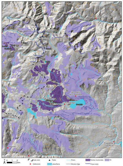
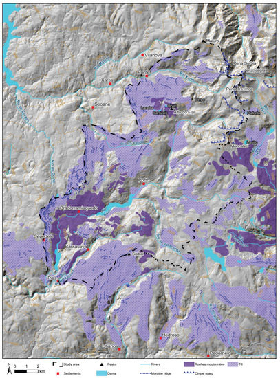
These figures allow the identification of the great till extension in the Trevinca sector, highlighting, especially in the eastern part, the current Sanabria Lake’s surroundings and the Tera valley, which runs from the highest elevations of the massif to the lake sector. In the western part, the most significant extension of till is found to the west of the Bibei valley, where some of the particular forms of this sector appear, such as the Cepedelo moraines (Figure 2).
4.2. Definition and Main Characteristics of Occidental Paleoglaciers
Figure 8 shows the western sector of Trevinca and each delimited paleobasins over which the moraines, ice thickness, and distribution were analyzed, and the ELA estimated.
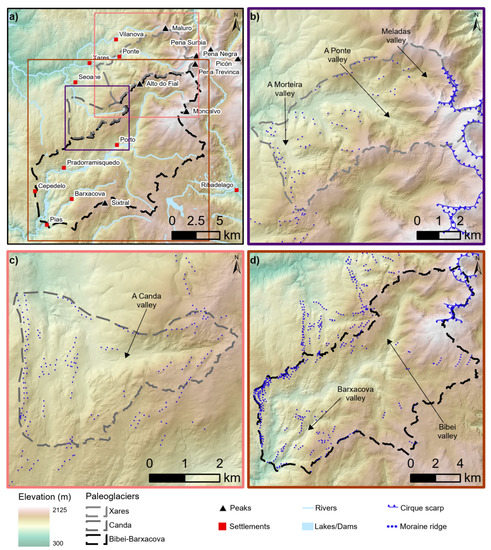
Figure 8.
Paleoglacial basins on occidental Trevinca Massif. (a) General map with the paleobasins of (b–d). (b) Xares paleobasin; (c) Canda paleobasin; and (d) Bibei-Barxacova paleobasin. The contour colors of (b–d) represent the extension marked with the same colors in (a).
Table 1 summarizes the main characteristics of each paleobasin. The largest is the Bibei-Barxacova paleobasin, which includes two of the central valleys of the Trevinca area, especially the Bibei Valley. On the other hand, the highest elevation corresponds to the Xares paleobasin, as its upper part is in Pena Trevinca (2127 m).

Table 1.
Palobasins characteristics. Their extension is in Figure 8.
According to the glacial dynamics of the paleobasins, some of their main characteristics can be defined as follows:
The Xares glacial complex (Figure 8b) includes four central valleys: Morteira, Ponte, Couto, and Meladas. Various landforms of glacial origin can be observed in them, such as the cradle valley of Ponte, the glacial cirque of Meladas, or the lateral shoulders of the Morteira Valley. This is also indicative of the importance of ice in this area, where the glacier tongue of the valley of A Morteira exceeds 8 km [43].
The Canda glacial complex (Figure 8c) stands out for their headwaters amphitheater and the moraine ridges found in the interfluve of the Canda and Bibei rivers. In addition, there are visible till outcrops of great importance in Valdín and Seoane, located north of the sector.
The Bibei-Barxacova glacial complex (Figure 8d) is the largest of those analyzed in the western Trevinca. From previous studies, it was the area where the ice reached the highest thickness [40], being able to highlight the spectacular moraine arches in Cepedelo on the western margin of the Bibei Valley (Figure 2a,b). On the other hand, as shown in previous works [43], the glaciolacustrine deposits of Pías in the extreme southwest stand out.
4.3. Moraine Ridges Distribution at the Occidental Sector
From the mapping of paleoglacial landforms and the methods described in Section 3.1 and Section 3.2.1, four categories were estimated for the moraine ridges distribution (Table 2). The most significant number was found in the two low levels, between 1339.81 and 1593.67 m, where 61% of them were located. This fact fitted perfectly with previous studies because there were zones with significant environmental alternations and differences in the ice extent. This fact allowed us to identify a substantial number of glacial paleo-geoforms.
Table 2.
General elevational moraine distribution using Jenks’s method.
The same technique for analyzing the distribution of moraine ridges was applied to the three paleobasins. Details for each are shown in Table 3. The most significant number of moraine ridges identified was found in the Bibei-Barxacova paleoglacier (194), followed by Canda (60), and finally, Xares (46).
Table 3.
Elevational moraine ridge characteristics in each paleoglacier.
The distribution of moraine ridges in elevation followed a pattern similar to that indicated in Table 2, except for Canda, where category IV represented a high percentage (25%). The Canda and Bibei-Barxacova complexes had a lower maximum elevation than Xares, with the highest in Bibei-Barxacova at 1784 m, almost 150 m below Xares. Figure 9 identifies the different moraines in each sector according to the elevation categories described in Table 2.
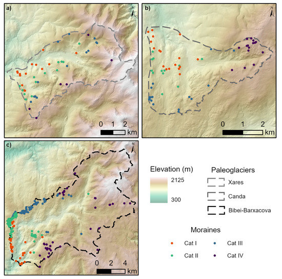
Figure 9.
Moraine ridges distribution based on Table 2 categories. (a) Xares; (b) Canda; and (c) Bibei-Barxacova.
4.4. Relation between Moraine Ridges and the Glacial Phases
The phases marked by the moraine ridges indicated a maximum in the first group and a subsequent retreat of the others until the glaciers’ final confinement in the massif’s highest areas.
Category I (Table 2 and Table 3) is related to the maximum glacial advance. It is linked to the local last glacial maximum (lLGM) when the glacial surface in the massif reaches its maximum extension and thickness. Several studies mark this phase around 44–27 ka on both flanks of the Trevinca Massif [7,60,61,62]. This idea of maximum glacial advance is also supported by the dating of Pérez-Alberti et al. [43] in Pías and Vidal Romaní and Fernández-Mosquera [63] in the Cenza Glacier, in the Manzaneda Massif.
Category II represents a phase of glacier recession and stabilization linked to the most critical retreats from 22 to 19 ka, which may have extended until at least 17.9 ka [62]. In this phase, the glaciers would rise to above 1400 m. This phase is located in different areas of the northwest depending on the analyzed site but always around the global local glacier maximum (gLGM) and its subsequent retreat [7,43,61].
In the case of the third category (III), it is related to a phase of glacial ascent between 1459 and 1593 m [7,61,64]. In most of the Galician mountains, a phase of glacial disappearance would begin, which can be related to dating such as Vidal Romaní and Fernández-Mosquera [63] in the Manzaneda Massif (16 ± 7 ka).
Finally, category IV includes the glacial vestiges of the final deglaciation phase in the Trevinca sector and generally in the northwestern mountains. This terminal phase can be placed between 16 and 11 ka, with moraines found above 1500–1600 m to the highest parts. In the case of the western sector of Trevinca, the highest value is at 1933 m [7,62].
4.5. Paleoglacial Extension and Ice Thickness
Figure 10 represents the ice thickness in each analyzed paleobasin. The Bibei-Barxacova paleobasin is the largest, with more than 143 km2 (Table 4), and where the ice reached the most significant thickness, both in mean (218.16 m) and maximum (527.03 m) values.
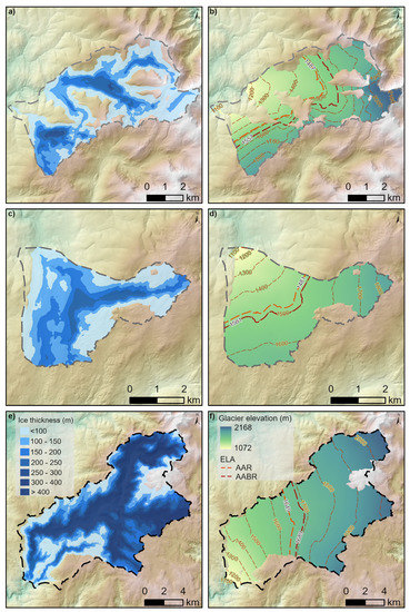
Figure 10.
Paleoglaciers’ characteristics. (a,c,e) represent the ice thickness in Xares, Canda, and Bibei-Barxacova, respectively; (b,d,f) paleoglacier elevation in Xares, Canda, and Bibei-Barxacova, respectively. The ELA was estimated with a 0.67 ratio for AAR and 1.75 for the AABR method.
Table 4.
Main characteristics of paleoglaciers.
In the case of the Xares Glacier, Figure 10a,b highlight the different relevance of each valley. In this case, it is possible that the ice cover was underestimated in the lower part of the Meladas Valley due to the methods used to calculate the thickness and design of the valley. The importance of the ice in the Bibei Valley mentioned above is evident in Figure 10e,f.
As previously described, the Canda paleoglacier was the smallest in extent (Table 4 and Figure 10c,d). However, the maximum ice thickness exceeded that of the Xares by almost 100 m due to this area’s topography and the great elevational differences. The mean thickness values were lower, with 101 and 116 m for Xares and Canda, respectively, values much lower than that of Bibei, where the mean ice thickness exceeded 218 m.
The same pattern was observed in the length of the glacier tongues (Table 4), where Bibei-Barxacova showed the highest value with 27.26 km, while for Xares and Canda, it was below 8 km.
4.6. ELA Estimation
Figure 10b,d, and f show the position of the ELA in each of the analyzed sectors using the AABR (1.75) and AAR (0.67) methods. Table 5 compiles the values for the different ELA approaches.
Table 5.
General information about ELA estimation in each paleoglacier.
The highest ELA values were in the Bibei-Barxacova paleoglacier, with values consistently above 1569 m. On the other hand, the lower values alternated between Xares and Canda, depending on the method used for the estimation. With the usual selection of values for the AABR and AAR [20,59], the lowest values corresponded to the Canda paleoglacier, only 6 m below that of the Xares paleoglacier in the AAR estimation (0.67).
5. Discussion
After an exhaustive review of previous works on the Trevinca Massif and the surrounding zones, it is necessary to mention that the glacial modeling in this area has been investigated for more than a century [65], being carried out over time approaches from multiple perspectives [4,6,21,22,23,31,36,40,43,66,67,68]. A significant part of the works have focused on the eastern sector of the massif, in the surroundings of Lake Sanabria, so the analysis of the western part of Trevinca is of great interest to know the differences and similarities between both slopes.
As it occurred in other sectors recently, research has focused on the paleoenvironmental reconstruction linked to the pollen record of zones such as Sanabria Lake [69,70,71,72], in addition to the research on the extent of the glacial surface and inherited forms in the eastern area [36,38,73,74] and the establishment of numerical chronologies [43,62].
Cartography has been of great interest to geomorphology since its beginnings. Still, the last decades have seen an important advance thanks to the evolution of new technologies such as GIS and editing software. In this sense, several publications in the Iberian Peninsula have created representations of the glacial geomorphology at different scales [12].
One of the critical elements in this mapping is the moraine ridges. These have served as the basis for the delimitation of paleoglacial basins, being used as limits of the ice expansion [11]. The primary analysis of the moraine ridges considered the western Trevinca complex to adapt the study to the interest area. For this reason, the elevational categories thresholds varied slightly from other works in which different nearby mountain ranges were included [40].
In the distribution of the moraine ridges, the importance of the Bibei Valley and its confluence with the Barxacova Valley in the extension of the ice was corroborated. This sector showed the highest number of identifiable moraines (194), while that of the other two did not exceed 60. It should be noted that in the Bibei-Barxacova, the moraines appeared preferentially on the valley sides at the ends of the analyzed area, highlighting the Cepedelo sector (Figure 2a,b). On the other hand, in the case of the Canda glacial complex, due to the evolution of the glacial mass, most of the moraines identified were in the highest part of the valley (Table 3). In contrast, in the case of Xares, the moraines were widely distributed due to the subdivision of the sector into several smaller valleys.
These moraine accumulations were preserved, especially on flat or gently sloping summits on the valleys’ flanks, indicating that the ice exceeded the valleys during their maximum advance, showing flow directions transversal to them. Large erratic blocks also corroborated this supraglacial transport, such as those located in the interfluve of the Bibei and Barxacova valleys linked to the maximum ice extension [36].
Previous studies on the western Trevinca estimated the extent of paleoglaciers at 326.5 km2 [40] during the lLGM when Bibei’s glacier tongue reached 30 km; in this study, this value was 27.26 km (Table 4). In the case of the eastern sector, centered in the Tera Valley and the Sanabria area, ice thicknesses were estimated quite similarly in the two existing studies (400–454 m in Rodriguez-Rodríguez et al. [38] and 457 m in the work of Fernández-Fernández [10].
These characteristics fitted perfectly with previous studies, where different references to the smoothed shape appeared, especially in the higher areas. This was related to the appearance, during the Pleistocene, of an ice field drained by numerous radial glacier outlets using the existing drainage network [39]. During the maximum advance, the glaciers formed several groups of well-defined lateral moraines, although no deposits could be identified in the lower parts of the valleys, showing, however, the bottom and sides of the valleys’ glacial evidence (Figure 2), such as polishing and the development of roche moutonnée [6,43].
The phases described in this analysis (Table 2 and Table 3) through the grouping of the moraine ridges fitted clearly with previous studies in this area. This could be related to the Pías sector in the Bibei Valley, where the rear part of the terminal moraine was dated by OSL of three layers of fluvioglacial deposits, obtaining ages of 27–33 ka for the maximum glacial advance [43]. These values also fitted with the studies elaborated at Sanabria Lake and San Martín de Castañeda [38,73,74]. Different studies have placed the minimum elevation for the glacial fronts of the Tera and Bibei valleys between 900 and 950 m, with several glacial cirques remaining in the Trevinca Massif in the Holocene as vestiges of the importance of ice in this sector previously [1]. The subsequent phases of glacial recession have also left their mark on the landscape, and the presence of till and glaciotectonic processes in areas above the maximum advance can be verified [37] (Figure 2f). Moreover, these values are corroborated by studies carried out in the eastern part of the massif [62]. In this evolution, there is a generalized retreat of the ice, with some phase of readvancement detected in the surroundings of Sanabria [73] but which ends with the enclosure of the glaciers in the highest elevations of the massif [7,64,73].
Despite the previous explanations, it would not seem correct to extrapolate these values to the entire massif. In previous works, it could be seen how the northern valleys could work both as independent valley glaciers or as outlet glaciers channeled through the preglacial valleys, as was the case for the Seoane Glacier [36]. The relationship between the dynamics of these forms and the main ice mass remains to be studied. Likewise, their relationship with the eastern (Tera Valley and Sierra de la Cabrera) and northern (Val de Casaio) sectors needs to be clarified. With these premises, extrapolating the results achieved in this sector to the whole mountain range would be risky.
The long period of studies in this sector has favored that the explanation of the geoforms and the definition of the parameters that estimate the behavior of this area have varied. This is perceived in the ELA estimation, where Stickel [21] defined it at 1500 m, while Schmitz [22] placed it at 1600 m. In this case, we estimated values that differed between the three western sectors and varied between 1427 and 1839 m depending on the calculation method.
The values obtained were similar to those of recent studies, which placed the ELA in the Tera Valley between 1520 and 1900 m [73], or the work of Fernández-Fernández et al. [10] for the eastern sector of Sanabria, where the ELA elevation varied between 1637 and 1796 m. These values were also similar to Serra da Estrela (1643 m) [75], with a comparable location and characteristics, or for some approximation in the Galician case, such as that of Hernández-Pacheco [76] for Manzaneda, where he placed the ELA at 1428 m. The variations in the ELA values in the context of the northern Iberian Peninsula were also previously analyzed concerning the climatic variations [60], a comparison that was extended to other sectors of the European continent, as in the case of Ribolini et al. [77] for the analysis of glaciers in southern Europe.
Regarding new technologies and studies on a glacier’s influence and its reconstruction, the possibilities offered by the GlaRe tool should be highlighted; it allows a very quick estimation with basic processing knowledge. This tool has prompted multiple works in which it was applied to obtain comparable results to those obtained with other methods [54,55,78]. In sectors with glaciers no longer active, the estimation can be more complex, so it is of great interest to expand the analyzing zones using this tool for a better calibration, mainly through improving processing techniques.
As mentioned in the main GlaRe tool paper [11], that method underestimates the ice thickness and volume with the different possible approximations. This could be perceived in the case of the limits of the glacier extension, where the ice thickness should have been more significant to form the moraine ridges that were identified, such as those around Cepedelo (Figure 7) or in the lower part of the Xares glacial complex.
As with GlaRe, the approach of Pellitero et al. [59] for estimating the ELA is of great relevance in this study since it allowed us to quickly obtain the central values that affected or had affected these sectors. As mentioned previously, the values were comparable to other studies where the authors applied different methodologies.
6. Conclusions
The values obtained, as well as the distribution of glacial evidence, allowed us to distinguish the maximum glacial advance of this area, which fitted with that proposed for other massifs of the northwest of the Iberian Peninsula [79] and for other mountainous sectors of the Iberian Peninsula, especially the southern slopes of the Pyrenees, which are usually used as reference [80,81]. The phases described by grouping the moraine ridges corresponded clearly with those of previous studies in which different dating methods were used.
This work estimated the maximum ice thicknesses, which reached 527.03 m in the case of the Bibei-Barxacova paleoglacier, and its minimum value in the Xares paleoglacier, with 292.51 m. This dynamic was similar for the average thickness, with 218.16 m and 101.97 m, respectively. Regarding the ice extent, the smallest paleoglacier was the Canda one, with 14.85 km2 of ice, while in the Bibei-Barxacova paleoglacier, the ice mass extent reached 143.74 km2.
Regarding the ELA, the highest values corresponded to Bibei-Barxacova, exceeding 1800 m in some methods. The maximum differences between the three analysis sectors were around 200 m.
It was also possible to demonstrate the facilities offered by new technologies for reconstructing these environments and their simplicity of processing for estimating the ice thickness using the GlaRe tool and obtaining the ELA by different methods.
This study showed a detailed characterization of the glacial forms in the Trevinca Massif, especially in their western part. From this analysis, it is possible to carry out different samplings to find the correspondence of the geoforms with each of the considered phases.
Author Contributions
Conceptualization, A.P.-A. and A.G.-P.; methodology, A.P.-A. and A.G.-P.; software, A.G.-P.; formal analysis, A.P.-A. and A.G.-P.; writing—original draft preparation, A.G.-P. and A.P.-A.; writing—review and editing, A.P.-A.; visualization, A.P.-A. and A.G.-P. All authors have read and agreed to the published version of the manuscript.
Funding
A.G.-P. is supported by a postdoctoral contract from the program named “Programa de axudas de apoio á etapa inicial de formación posdoutoral (2022)” founded by Xunta de Galicia (Government of Galicia, Spain). Reference number: ED481B-2022-090.
Data Availability Statement
The data presented in this study are available on request from the authors. The data are not publicly available due to size and institutional restrictions.
Acknowledgments
We would like to thank the two anonymous reviewers for their constructive feedbacks and comments that have resulted in an improved manuscript.
Conflicts of Interest
The authors declare no conflict of interest.
Abbreviations
The following abbreviations are used in this manuscript:
| AABR | Area–altitude balance ratio |
| AAR | Accumulation area ratio |
| DEM | Digital elevation model |
| ELA | Equilibrium-line altitude |
| GIS | Geographic information system |
| gLGM | Global last glacial maximum |
| LiDAR | Light detection and ranging |
| lLGM | Local last glacial maximum |
| OSL | Optically stimulated luminescence |
| PNOA | Plan Nacional de Ortofotografía Aérea (Spain) |
References
- Oliva, M.; Palacios, D.; Fernández-Fernández, J.; Rodríguez-Rodríguez, L.; García-Ruiz, J.; Andrés, N.; Carrasco, R.; Pedraza, J.; Pérez-Alberti, A.; Valcárcel-Díaz, M.; et al. Late Quaternary glacial phases in the Iberian Peninsula. Earth-Sci. Rev. 2019, 192, 564–600. [Google Scholar] [CrossRef]
- Harris, C.; Arenson, L.U.; Christiansen, H.H.; Etzelmüller, B.; Frauenfelder, R.; Gruber, S.; Haeberli, W.; Hauck, C.; Hölzle, M.; Humlum, O.; et al. Permafrost and climate in Europe: Monitoring and modelling thermal, geomorphological and geotechnical responses. Earth-Sci. Rev. 2009, 92, 117–171. [Google Scholar] [CrossRef]
- Oliva, M.; Serrano, E.; Gómez-Ortiz, A.; González-Amuchastegui, M.; Nieuwendam, A.; Palacios, D.; Pérez-Alberti, A.; Pellitero-Ondicol, R.; Ruiz-Fernández, J.; Valcárcel-Díaz, M.; et al. Spatial and temporal variability of periglaciation of the Iberian Peninsula. Quat. Sci. Rev. 2016, 137, 176–199. [Google Scholar] [CrossRef]
- Sáenz Ridruejo, C. Varves glaciares del Alto Bibey. Rev. Obras Públicas 1968, 115, 339–350. [Google Scholar]
- Vandenberghe, J.; French, H.M.; Gorbunov, A.; Marchenko, S.; Velichko, A.A.; Jin, H.; Cui, Z.; Zhang, T.; Wan, X. The Last Permafrost Maximum (LPM) map of the Northern Hemisphere: Permafrost extent and mean annual air temperatures, 25–17 ka BP. Boreas 2014, 43, 652–666. [Google Scholar] [CrossRef]
- Pérez-Alberti, A.; Covelo Abeleira, P. Reconstrucción paleoambiental de la dinámica glaciar del Alto Bibei durante el Pleistoceno reciente a partir del estudio de los sedimentos acumulados en Pías (Noroeste de la Península Ibérica). In Dinámica y Evolución de Medios Cuaternarios; Xunta de Galicia: Santiago de Compostela, Spain, 1996; pp. 115–130. [Google Scholar]
- Viana-Soto, A.; Pérez-Alberti, A. Periglacial deposits as indicators of paleotemperatures. A case study in the Iberian Peninsula: The mountains of Galicia. Permafr. Periglac. Process. 2019, 30, 374–388. [Google Scholar] [CrossRef]
- Van Huissteden, K.; Vandenberghe, J.; Pollard, D. Palaeotemperature reconstructions of the European permafrost zone during marine oxygen isotope stage 3 compared with climate model results. J. Quat. Sci. 2003, 18, 453–464. [Google Scholar] [CrossRef]
- Benn, D.I.; Hulton, N.R.J. An ExcelTM spreadsheet program for reconstructing the surface profile of former mountain glaciers and ice caps. Comput. Geosci. 2010, 36, 605–610. [Google Scholar] [CrossRef]
- Fernández-Fernández, J.M. Aplicaciones de los sistemas de información geográfica en la reconstrucción paleoglaciar: El caso de la Sierra Segundera (Zamora, España). Geofocus Rev. Int. Cienc. Tecnol. Inf. Geográfica 2015, 16, 5. [Google Scholar]
- Pellitero, R.; Rea, B.R.; Spagnolo, M.; Bakke, J.; Ivy-Ochs, S.; Frew, C.R.; Hughes, P.; Ribolini, A.; Lukas, S.; Renssen, H. GlaRe, a GIS tool to reconstruct the 3D surface of palaeoglaciers. Comput. Geosci. 2016, 94, 77–85. [Google Scholar] [CrossRef]
- Oliva, M.; Palacios, D.; Fernández-Fernández, J.M. Iberia, Land of Glaciers How the Mountains Were Shaped by Glaciers; Elsevier: Amsterdam, The Netherlands, 2021; p. 300. [Google Scholar]
- García-Ruiz, J.M.; Palacios, D.; de Andrés, N.; Valero-Garcés, B.L.; López-Moreno, J.I.; Sanjuán, Y. Holocene and ‘little ice age’ glacial activity in the Marboré cirque, Monte Perdido Massif, Central Spanish Pyrenees. Holocene 2014, 24, 1439–1452. [Google Scholar] [CrossRef]
- Fernandes, M.; Oliva, M.; Vieira, G.; Palacios, D.; Fernández-Fernández, J.M.; Delmas, M.; García-Oteyza, J.; Schimmelpfennig, I.; Ventura, J. Maximum glacier extent of the Penultimate Glacial Cycle in the Upper Garonne Basin (Pyrenees): New chronological evidence. Environ. Earth Sci. 2021, 80, 1–20. [Google Scholar] [CrossRef]
- Serrano, E.; González-Trueba, J.J.; Pellitero, R.; Gómez-Lende, M. Quaternary glacial history of the Cantabrian Mountains of northern Spain: A new synthesis. Geol. Soc. Lond. Spec. Publ. 2016, 433, 55–85. [Google Scholar] [CrossRef]
- Serrano, E.; González-Trueba, J.; Pellitero, R.; González-García, M.; Gómez-Lende, M. Quaternary glacial evolution in the Central Cantabrian Mountains (Northern Spain). Geomorphology 2013, 196, 65–82. [Google Scholar] [CrossRef]
- Pisabarro, A.; Pellitero, R.; Serrano, E.; Gómez-Lende, M.; González-Trueba, J. Ground temperatures, landforms and processes in an Atlantic mountain. Cantabrian Mountains (Northern Spain). Catena 2017, 149, 623–636. [Google Scholar] [CrossRef]
- Ruiz-Fernández, J.; Oliva, M.; Cruces, A.; Lopes, V.; da Conceição Freitas, M.; Andrade, C.; Garcia-Hernandez, C.; López-Sáez, J.A.; Geraldes, M. Environmental evolution in the Picos de Europa (Cantabrian Mountains, SW Europe) since the last glaciation. Quat. Sci. Rev. 2016, 138, 87–104. [Google Scholar] [CrossRef]
- Palacios, D.; Gómez-Ortiz, A.; Alcalá-Reygosa, J.; Andrés, N.; Oliva, M.; Tanarro, L.M.; Salvador-Franch, F.; Schimmelpfennig, I.; Fernández-Fernández, J.M.; Léanni, L. The challenging application of cosmogenic dating methods in residual glacial landforms: The case of Sierra Nevada (Spain). Geomorphology 2019, 325, 103–118. [Google Scholar] [CrossRef]
- Palma, P.; Oliva, M.; García-Hernández, C.; Gómez Ortiz, A.; Ruiz-Fernández, J.; Salvador-Franch, F.; Catarineu, M. Spatial characterization of glacial and periglacial landforms in the highlands of Sierra Nevada (Spain). Sci. Total Environ. 2017, 584–585, 1256–1267. [Google Scholar] [CrossRef] [PubMed]
- Stickel, R. Observaciones de Morfología Glaciar en el No de España. Bol. R. Soc. Esp. Hist. Nat. 1929, 29, 297–318. [Google Scholar]
- Schmitz, H. Glazialmorphologische Untersuchungen im Bergland Nordwestspaniens (Galicien/León); Kolner Geogr. Arb. 23; Univ. Köln: Köln, Germany, 1969. [Google Scholar]
- Pérez-Alberti, A. Nuevas observaciones sobre glaciarismo y periglaciarismo en el NW de la Península ibérica: La Galicia sudoriental. Acta GeolóGica HispáNica 1979, 14, 441–444. [Google Scholar]
- Hall-Riaza, J.F.; Valcárcel, M.; Blanco-Chao, R. Caracterización morfométrica de formas glaciares en cuña en las Sierras de Xistral, Teleno y Cabrera. Polígonos. Rev. Geogr. 2016, 28, 55. [Google Scholar] [CrossRef]
- Azor, A.; González Lodeiro, F.; Hacar Rodríguez, M.; Martín Parra, L.M.; Martínez Catalán, J.R.; Pérez Estaún, A. Estratigrafía y estructura del Paelozoico en el Dominio del Ollo de Sapo. In Proceedings of the Paleozoico Inferior de Ibero-América. Conferencia Internacional sobre el Paleozoico Inferior de Ibero-América, Mérida, Spain, 6–12 May 1992; pp. 469–483. [Google Scholar]
- Vidal Romaní, J.R.; Marti, K. The glaciation of Serra de Queixa-Invernadoiro and Serra do Gerês-Xurés, NW Iberia. A critical review and a cosmogenic nuclide (10Be and 21 Ne) chronology. Cad. Lab. Xeolóxico de Laxe. Rev. Xeoloxía Galega Hercínico Penins. 2015, 38, 25–43. [Google Scholar] [CrossRef]
- Valcárcel-Díaz, M.; Pérez-Alberti, A. Un ejemplo de glaciarismo de baja cota en el NW de la Península Ibérica: El valle de Queixadoiro. In Estudios Recientes en Geomorfología. Patrimonio, Montaña y dináMica Territorial; Universidad de Valladolid: Valladolid, Spain, 2002; Volume 205, p. 215. [Google Scholar]
- Hernández-Pacheco, F. El glaciarismo cuaternario de la Sierra de Queija-Orense, Galicia. Bol. R. Soc. Esp. Hist. Nat. 1957, 55, 27–74. [Google Scholar]
- Rodríguez-Guitián, M.; Pérez-Alberti, A.; Valcárcel-Díaz, M. El modelado glaciar en la vertiente oriental de la sierra de Ancares (noroeste de la Península Ibérica). Papeles Geogr. 1992, 18, 39–54. [Google Scholar]
- Valcárcel Díaz, M.; Rodríguez Guitián, M.; Pérez Alberti, A. Dinámica glaciar pleistocena del complejo Porcarizas-Valongo (Serra dos Ancares, NW Ibérico). In Avances en el Conocimiento Paleoambiental de las Montañas Lucenses; Diputación de Lugo: Lugo, Spain, 1996; pp. 53–64. [Google Scholar]
- Llopis Lladó, N. Sobre la morfología de los picos Ancares y Miravalles. An. Asoc. Española Prog. Cienc. (Rev. Las Cienc.) 1954, 19, 627–643. [Google Scholar]
- Kossel, U. Problemas geomorfológicos acerca de la determinación del máximo avance glaciar en la Sierra de Ancares (León-Lugo-Asturias). In Dinámica y Evolución de Medios Cuaternarios; Xunta de Galicia: Santiago de Compostela, Spain, 1996; Volume 131, p. 142. [Google Scholar]
- Pérez-Alberti, A. El patrimonio glaciar y periglaciar del Geoparque Mundial UNESCO Montañas do Courel (Galicia). Cuaternario Geomorfol. 2021, 35, 79–98. [Google Scholar] [CrossRef]
- Vidal-Romaní, J.; Aira-Rodríguez, M.; Santos Fidalgo, L. La glaciación finicuaternaria en el NO de la Península Ibérica (Serra do Courel, Lugo): Datos geomorfológicos y paleobotánicos. In Libro de Resúmenes. VIII Reunión Nacional Sobre el Cuaternario; Universidad de Valencia: Valencia, Spain, 1991. [Google Scholar]
- Aira, M.J.; Guitian Ojea, F. Contribución al estudio de los suelos y sedimentos de montaña de Galicia y su cronología por analisis polinico. I. Sierra del Caurel (Lugo). An. Edafol. Agrobiol. 1986, 45, 1189–1202. [Google Scholar]
- Rodríguez-Guitián, M.A.; Valcárcel-Díaz, M. Contribución al conocimiento del glaciarismo pleistoceno en la vertiente sur-occidental del Macizo de Peña Trevinca (Montañas Galaico-Sanabrienses, NW Ibérico). In Proceedings of the Geomorfología de España, Logroño, Spain, 14–16 September 1994. [Google Scholar]
- Dionne, J.; Pérez-Alberti, A. Observations of vertical cylindrical structures in an unconsolidated Quaternary deposit, in Spain. Geogr. Phys. Quat. 2001, 54, 343–349. [Google Scholar]
- Rodríguez-Rodríguez, L.; Domínguez-Cuesta, M.J.; Jimenez Sánchez, M. Reconstrucción en 3D del máximo glaciar registrado en la cuenca del Lago de Sanabria (Noroeste de España). Boletín Real Soc. Española Hist. Nat. (Sección Geol.) 2011, 105, 31–44. [Google Scholar]
- Rodríguez-Rodríguez, L.; Jiménez-Sánchez, M.; Domínguez-Cuesta, M.J.; González-Lemos, S. The glaciers around Lake Sanabria. In Iberia, Land of Glaciers; Elsevier: Amsterdam, The Netherlands, 2022; pp. 335–351. [Google Scholar]
- Pérez-Alberti, A.; Valcárcel-Díaz, M. Chapter 4.14—The glaciers in Eastern Galicia. In Iberia, Land of Glaciers; Oliva, M., Palacios, D., Fernández-Fernández, J.M., Eds.; Elsevier: Amsterdam, The Netherlands, 2022; pp. 375–395. [Google Scholar] [CrossRef]
- Valcarcel-Díaz, M.; Pérez-Alberti, A. Chapter 4.13—The glaciers in Western Galicia. In Iberia, Land of Glaciers; Oliva, M., Palacios, D., Fernández-Fernández, J.M., Eds.; Elsevier: Amsterdam, The Netherlands, 2022; pp. 353–373. [Google Scholar] [CrossRef]
- Oliva, M.; Serrano, E.; Fernández-Fernández, J.M.; Palacios, D.; Fernandes, M.; García-Ruiz, J.M.; López-Moreno, J.I.; Pérez-Alberti, A.; Antoniades, D. The Iberian Peninsula. In Periglacial Landscapes of Europe; Oliva, M., Nývlt, D., Fernández-Fernández, J.M., Eds.; Springer International Publishing: Cham, Switzerland, 2022; pp. 43–68. [Google Scholar] [CrossRef]
- Pérez-Alberti, A.; Valcárcel-Díaz, M.; Martini, P.I.; Pascucci, V.; Andreucci, S. Upper Pleistocene glacial valley-junction sediments at Pias, Trevinca Mountains, NW Spain. Geol. Soc. Lond. Spec. Publ. 2011, 354, 93–110. [Google Scholar] [CrossRef]
- Díez-Montes, A. La geología del Dominio “Ollo de Sapo” en las comarcas de Sanabria y Terra do Bolo. Ph.D. Thesis, University of Salamanca, Salamanca, Spain, 2006. [Google Scholar]
- Muñoz-Martín, A.; Álvarez, J.; Carbó, A.; De Vicente, G.; Vegas, R.; Cloetingh, S. La Estructura de la Corteza del Antepaís Ibérico; Geología de España; SGE-IGME: Madrid, Spain, 2004; pp. 591–596. [Google Scholar]
- Pérez-Alberti, A. Climatoloxía. In Xeografía de Galicia; Pérez-Alberti, A., Ed.; Sálvora: A Coruña, Spain, 1982. [Google Scholar]
- Meteogalicia. Meteogalicia. 2023. Available online: https://www.meteogalicia.gal/ (accessed on 3 January 2023).
- IGN. Instituto Geográfico Nacional. 2023. Available online: https://www.centrodedescargas.cnig.es/ (accessed on 2 January 2023).
- Lambiel, C.; Maillard, B.; Regamei, B.; Martin, S.; Kummert, M.; Schoeneich, P.; Pellitero Ondicol, R.; Reynard, E. Adaptation of the geomorphological mapping system of the University of Lau sanne for ArcGIS. In Proceedings of the 8th International Conference on Geomorphology (IAG), Paris, France, 27–31 August 2013. [Google Scholar]
- Jenks, G.F. The data model concept in statistical mapping. Int. Yearb. Cartogr. 1967, 7, 186–190. [Google Scholar]
- R Core Team. R: A Language and Environment for Statistical Computing; R Core Team: Vienna, Austria, 2021. [Google Scholar]
- Temovski, M.; Madarász, B.; Kern, Z.; Milevski, I.; Ruszkiczay-Rüdiger, Z. Glacial geomorphology and Preliminary glacier reconstruction in the Jablanica mountain, Macedonia, central Balkan peninsula. Geosciences 2018, 8, 270. [Google Scholar] [CrossRef]
- Oien, R.; Spagnolo, M.; Rea, B.; Barr, I.; Bingham, R.G.; Jansen, J. Analysing palaeo cirque glacier equilibrium line altitudes as indicators of palaeoclimate across Scandinavia. In Proceedings of the EGU General Assembly 2020, Online, 4–8 May 2020. [Google Scholar]
- Paul, O.J.; Dar, R.A.; Romshoo, S.A. Paleo-glacial and paleo-equilibrium line altitude reconstruction from the Late Quaternary glacier features in the Pir Panjal Range, NW Himalayas. Quat. Int. 2021, 642, 5–16. [Google Scholar] [CrossRef]
- Campos, N.; Palacios, D.; Tanarro, L.M. Glacier reconstruction of La Covacha Massif in Sierra de Gredos (central Spain) during the Last Glacial Maximum. J. Mt. Sci. 2019, 16, 1336–1352. [Google Scholar] [CrossRef]
- Moulin, A.; Benedetti, L.; Vidal, L.; Hage-Hassan, J.; Elias, A.; Van der Woerd, J.; Schimmelpfennig, I.; Daëron, M.; Tapponnier, P. LGM glaciers in the SE Mediterranean? First evidence from glacial landforms and 36Cl dating on Mount Lebanon. Quat. Sci. Rev. 2022, 285, 107502. [Google Scholar] [CrossRef]
- Palacios, D.; Rodríguez-Mena, M.; Fernández-Fernández, J.M.; Schimmelpfennig, I.; Tanarro, L.M.; Zamorano, J.J.; Andrés, N.; Úbeda, J.; Sæmundsson, T.; Brynjólfsson, S. Reversible glacial-periglacial transition in response to climate changes and paraglacial dynamics: A case study from Héðinsdalsjökull (northern Iceland). Geomorphology 2021, 388, 107787. [Google Scholar] [CrossRef]
- Figueira, E.; Gomes, A.; Pérez-Alberti, A.; Chaminé, H.I. 3D modelling of the maximum ice extent and thickness of the palaeoglacier of Serra do Soajo, Northern Portugal. In Proceedings of the 10th International Conference on Geomorphology, Coimbra, Portugal, 12–16 September 2022. [Google Scholar] [CrossRef]
- Pellitero, R.; Rea, B.R.; Spagnolo, M.; Bakke, J.; Hughes, P.; Ivy-Ochs, S.; Lukas, S.; Ribolini, A. A GIS tool for automatic calculation of glacier equilibrium-line altitudes. Comput. Geosci. 2015, 82, 55–62. [Google Scholar] [CrossRef]
- Pérez-Alberti, A.; Valcárcel Díaz, M.; Blanco-Chao, R. Pleistocene glaciation in Spain. In Quaternary Glaciations–Extent and Chronology. Part I: Europe. Amsterdam, etc.; Developments in Quaternary Science 2; Elsevier: Amsterdam, The Netherlands, 2004. [Google Scholar]
- Pérez-Alberti, A.; Rodríguez-Guitián, M.; Valcárcel-Díaz, M. Las Formas y Depósitos Glaciares en las Sierras Orientales y Septentrionales de Galicia (NW Península Ibérica); Xunta de Galicia: A Coruña, Spain, 1993; pp. 61–90. [Google Scholar]
- Rodríguez-Rodríguez, L.; Jiménez-Sánchez, M.; Domínguez-Cuesta, M.J.; Rinterknecht, V.; Pallàs, R.; Bourlès, D.; Valero-Garcés, B. A multiple dating-method approach applied to the Sanabria Lake moraine complex (NW Iberian Peninsula, SW Europe). Quat. Sci. Rev. 2014, 83, 1–10. [Google Scholar] [CrossRef]
- Vidal Romaní, J.R.; Fernández-Mosquera, D. Glaciarismo Pleistoceno en el NW de la peninsula Ibérica (Galicia, España-Norte de Portugal). Enseñanza Las Cienc. Tierra 2005, 13, 270–277. [Google Scholar]
- Martínez Cortizas, A.; Moares Domínguez, M.M.; Pérez-Alberti, A. Los Procesos Periglaciares en el Noroeste de la Península Ibérica; Universidad de Granada: Granada, Spain, 1994; pp. 33–54. [Google Scholar]
- Fernández-Duro, C. El Lago de Sanabria o de San Martín de Castañeda. Bol. Real Soc. Geogr. 1879, 6, 65. [Google Scholar]
- Taboada, J. El lago de San Martín de Castañeda. Bol. Soc. Esp. Hist. Nat. 1913, 13, 860–883. [Google Scholar]
- Pérez-Alberti, A. Procesos periglaciares e glaciares no Nordeste de Galicia. Rev. Terra 1983, 3, 78–86. [Google Scholar]
- Pérez-Alberti, A. La Geomorfología de la Galicia Sudoriental: Problemas Geomorfológicos de un Macizo Hercínico de la Fachada atlántica Ibérica: Centro-Sudeste de Galicia. Ph.D. Thesis, Universidade de Santiago de Compostela, A Coruña, Spain, 1990. [Google Scholar]
- Luque, J.A. El Lago de Sanabria: Un Sensor de Las Oscilaciones Climáticas del Atlántico Norte Durante Los últimos 6.000 Años; Universitat de Barcelona: Barcelona, Spain, 2003. [Google Scholar]
- Rico, M.T.; Valero-Garcés, B.L.; Vega, J.C.; Moreno Caballud, A.; González-Sampériz, P.; Morellón, M.; Mata, M.P. El Registro Sedimentario del Lago de Sanabria Desde la última Deglaciación; Asociación Española para el Estudio del Cuaternario; Universidad Politécnica de Madrid: Madrid, Spain, 2007. [Google Scholar]
- Jambrina-Enríquez, M.; Rico, M.; Moreno, A.; Leira, M.; Bernárdez, P.; Prego, R.; Recio, C.; Valero-Garcés, B.L. Timing of deglaciation and postglacial environmental dynamics in NW Iberia: The Sanabria Lake record. Quat. Sci. Rev. 2014, 94, 136–158. [Google Scholar] [CrossRef]
- Jambrina-Enríquez, M.; Recio, C.; Vega, J.C.; Valero-Garcés, B. Tracking climate change in oligotrophic mountain lakes: Recent hydrology and productivity synergies in Lago de Sanabria (NW Iberian Peninsula). Sci. Total Environ. 2017, 590, 579–591. [Google Scholar] [CrossRef] [PubMed]
- Cowton, T.; Hughes, P.D.; Gibbard, P.L. Palaeoglaciation of Parque Natural Lago de Sanabria, northwest Spain. Geomorphology 2009, 108, 282–291. [Google Scholar] [CrossRef]
- Rodríguez-Rodríguez, L.; Jiménez-Sánchez, M.; Domínguez-Cuesta, M.J.; Rico, M.T.; Valero-Garcés, B. Last deglaciation in northwestern Spain: New chronological and geomorphologic evidence from the Sanabria region. Geomorphology 2011, 135, 48–65. [Google Scholar] [CrossRef]
- Vieira, G. Combined numerical and geomorphological reconstruction of the Serra da Estrela plateau icefield, Portugal. Geomorphology 2008, 97, 190–207. [Google Scholar] [CrossRef]
- Hernández-Pacheco, F. Huellas Glaciares en la Sierra de Queija (Orense). Bol. R. Soc. Esp. Hist. Nat. 1949, 47, 97–102. [Google Scholar]
- Ribolini, A.; Bini, M.; Isola, I.; Spagnolo, M.; Zanchetta, G.; Pellitero, R.; Mechernich, S.; Gromig, R.; Dunai, T.; Wagner, B.; et al. An Oldest Dryas glacier expansion on Mount Pelister (Former Yugoslavian Republic of Macedonia) according to 10Be cosmogenic dating. J. Geol. Soc. 2017, 175, 100–110. [Google Scholar] [CrossRef]
- Spagnolo, M.; Ribolini, A. Glacier extent and climate in the Maritime Alps during the Younger Dryas. Palaeogeogr. Palaeoclimatol. Palaeoecol. 2019, 536, 109400. [Google Scholar] [CrossRef]
- Valcárcel-Díaz, M.; Blanco-Chao, R.; Martínez-Cortizas, A.; Pérez-Alberti, A. Estimation of paleotemperatures in Galicia during the last glacial cycle from geomorphological and climatic data. In Investigaciones Recientes de la Geomorfología Española; Gómez-Ortiz, A., Salvador Franch, F., Eds.; Universitat de Barcelona: Barcelona, Spain, 1998; pp. 661–664. [Google Scholar]
- Bordonau, J.; Serrat, D.; Vilaplana, J.M. Las fases glaciares cuaternarias en los Pirineos. In The Late Quaternary in the Western Pyrenean Region; Servicio Editorial Universidad del País Vasco: Bilbao, Spain, 1992; pp. 303–312. [Google Scholar]
- Martínez de Pisón, E.; Serrano, E. Morfología Glaciar del valle del Tena (Pirineo Aragonés). In Las Huellas Glaciares de las Montañas españOlas; Servicio de Publicaciones e Intercambio Científico: A Coruña, Spain, 1998; pp. 239–261. [Google Scholar]


Disclaimer/Publisher’s Note: The statements, opinions and data contained in all publications are solely those of the individual author(s) and contributor(s) and not of MDPI and/or the editor(s). MDPI and/or the editor(s) disclaim responsibility for any injury to people or property resulting from any ideas, methods, instructions or products referred to in the content. |
© 2023 by the authors. Licensee MDPI, Basel, Switzerland. This article is an open access article distributed under the terms and conditions of the Creative Commons Attribution (CC BY) license (https://creativecommons.org/licenses/by/4.0/).