Abstract
At a time when wars and pandemics have disrupted the world order and deeply damaged international agreements, more people are talking about the energy and food independence of the nation-states. It is clear that the achievement of these objectives will not be rapid, but it is also clear that land use must take account of these important aspects. The over-dimensioning of the settled areas presents illogically in almost all municipal urban planning plans regardless of their geographical location, demographic dynamics, and values of the administered territory; it certainly constitutes an obstacle to effective land use. The work presented here aims to analyze the effects on agricultural production of the transformations envisaged by the plans of the provinces of Modena and Reggio nell’Emilia, while also providing solutions that could promote the sustainability of the interventions planned in these areas of high agri-food value.
1. Introduction
Plains represent the most fragile and most densely populated physical environments on earth, and they are easy to cultivate due to the presence of river water. However, human activities have produced intense and pervasive modifications of their natural systems. These transformations have been particularly pronounced in the Po Valley, the largest floodplain in Southern Europe. It covers an area of 47,820 km2 (15% of the Italian territory) and represents one of the largest resources for agriculture at the European level [1]. Despite this premise, in Italy, food self-sufficiency, i.e., the ability to produce with only domestic raw materials and without recourse to imports, is the prerogative of only a few sectors. According to data from Federalimentare (http://www.federalimentare.it/ (accessed on 15 December 2022)), Italy is only completely independent about a few products (e.g., wine, rice, and white meat). In contrast, around 40% of soft wheat, prepared meats, and 60% of raw materials for oil production are imported. Therefore, in Italy at present, food self-sufficiency is a difficult goal to achieve. Urbanization, which is still poorly controlled by stringent regulations, continues to erode agricultural land with an associated loss of the biophysical and economic value of this ecosystem service [2,3,4], but the forced entry of the new Common Agricultural Policy (CAP 2023–2027) also performs a role. The idea of regulating agricultural land use at the EU level is undoubtedly an added value to the European production system, with positive repercussions on both the agricultural markets and the security of supply while ensuring reasonable prices for consumers (Ministry of Agriculture, Food Sovereignty and Forestry). The new CAP, however, does not allow the productive use of set-aside areas and all pastures. In addition, it does not allow an increase in irrigated areas (to the objectives of the Green Deal). Therefore, agricultural production faces a twofold challenge: increasing production, protecting nature, and preserving biodiversity. The recent war conflict and the global pandemic have worsened the situation causing severe economic, energy, and food repercussions on an international scale, changing geopolitics, and global supply chains. The recent war and the global pandemic have worsened the situation causing severe economic, energy, and food repercussions on an international scale, changing geopolitics and global supply chains. The emerging food crisis, due to rising food prices, dwindling stocks, climate change, energy, fertilizer and pesticide supplies, and the progressive increase in the world population to 8 billion in November 2022, (Antonio Gutierres, UN Secretary-General), makes it necessary to identify a strategy to contain the negative impacts on the entire food supply chain. Furthermore, agricultural production will have to increase by 60% to meet global food demand in 2050 [5]. For several years now, the soil issue has been on the political agenda of the European Union, but also of several nation-states as the quality of human life depends on its sustainable use and preservation. Similar goals were also reiterated in the 2030 Agenda, emphasizing how soils should be governed to preserve their potential to provide assets and services [6]. Soil performs a vital role for many reasons, it is the basis of agricultural land and forest areas and is, therefore, essential for food, textile, and timber production. However, it also performs other, non-insignificant roles, such as filtering water, reducing the risk of floods and droughts, helping reduce climate change’s effects, and supporting biodiversity. Despite the critical role soils perform, there is still no EU legislation protecting soils in the same way as water resources, air, or other environmental substrates. Urbanization and sealing can thus quickly occur, isolating the soil from the atmosphere and reducing its capacity to provide services [7]. The pressure that soils are under today is such that we cannot wait any longer for stringent regulations to protect their integrity and ensure their sustainable use over time. A well-established practice in Italian town planning is that of oversizing the new parts of the urban area drawn in the plans, which are detached from the effective demographic dynamics and from the economic potential of the territorial contexts in which they are located [8,9,10]. Starting from these latter considerations, the proposed work aims to analyze the impact of the plans transformation forecasts on the agricultural system of the provinces of Modena and Reggio nell’Emilia and their relationship with the real demographic dynamics of the territory in question. The results provide evidence of the impact on the local economic system and how the absence of a link to the real demographic trend of the area could lead to significant land savings with immediate positive effects. The methodology adopted could then also be applied in other national and international contexts.
2. Study Area
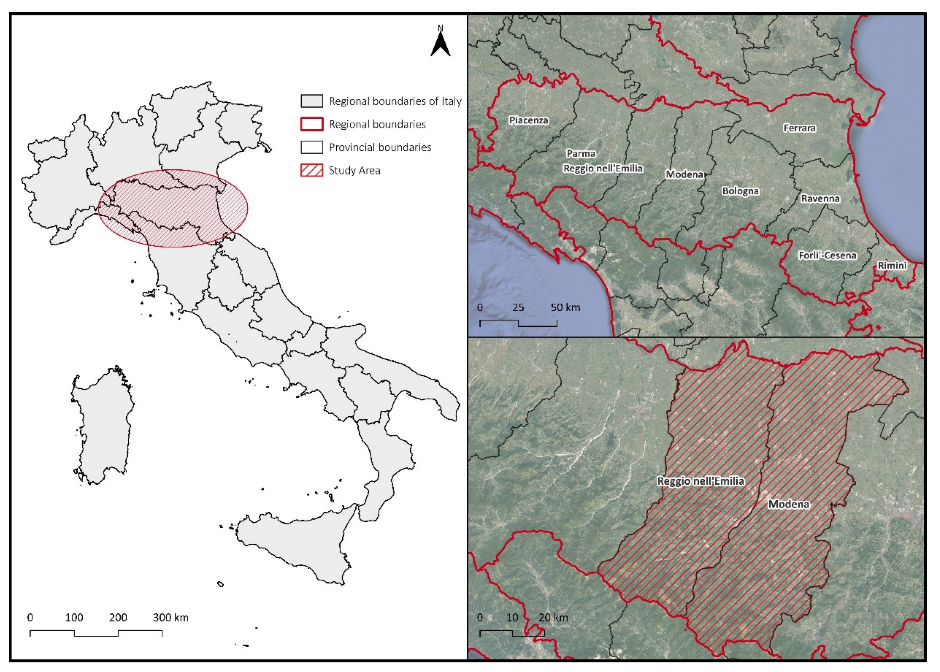
The area of interest covers the entire provinces of Modena and Reggio nell’Emilia (Figure 1), which extend over an area of just under 5000 km2 (about 25% of the regional territory, larger than that of the Molise region), involving 89 municipalities out of a total of 330. The average size of the analyzed municipalities is 56 km2, which is larger than the national average (38 km2). Data from the 2021 ISTAT census show that over 1,200,000 inhabitants (30% of the regional total) live in this area, with a population density above the national average of 250 inhabitants/sq km. In the last ten years, the resident population has increased by about 30,000, most in the two provincial capital municipalities and those of Carpi, Vignola, and Castelfranco Emilia, with active balances of over 1000 new residents. From an economic point of view, the Emilia-Romagna region ranks third in terms of average total IRPEF income (the tax year 2020 MEF data), and even in the municipalities of the surveyed area, the per capita income is higher than the national average value, except for the municipalities in the southern part, located in the inland areas along the Apennines. This region, according to Eurostat for the two-year period 2019/2020, is in eighth place in Europe for industrial value added. Specifically, the two studied provinces, according to Istat data, for 2020 have a per-capita industrial value added of EUR 32,400 for the Province of Modena and EUR 31,700 for the province of Reggio nell’Emilia, respectively in seventh and ninth place among all the Italian provinces. Data processed by ISPRA on national soil consumption show that the Emilia-Romagna region is one of the Italian regions with the highest percentage of consumed soil (the third after Lombardy and Veneto with over 200,000 hectares by 2021) with an annual increase recorded between 2020 and 2021 of just under 6 km2. In this context, the investigated provinces are among the most urbanized at the regional level with percentages of consumed soil exceeding 11% of the total and those in which the most soil has been consumed in the last year.
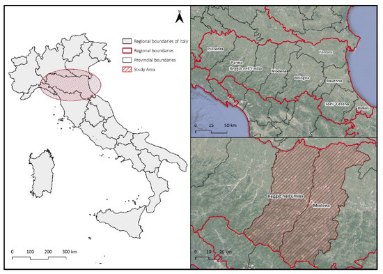
Figure 1.
Geographical context of the study area.
3. Materials and Methods
The data used for the analyses carried out for this work come mainly from the geoportal of the Emilia-Romagna region (https://geoportale.regione.emilia-romagna.it/ (accessed on 27 October 2022)). In particular, land use data refer to the year 2017, whose Minimum Mapping Unit (MMU) is equal to 1600 m2, while the thematic detail reaches up to the fourth level of the Corine Land Cover nomenclature (CLC). Data of plans forecasts come from the geoportal of the Emilia-Romagna region and each plan has information about the update year and the plan typology. The synoptic descriptions reported in the plans legends have been traced back to those sensu D.M. 1444/68 to obtain a homogeneous picture and easily readable, this procedure allow to develop the Planning Tool Mosaic [9]. The plan forecast was organized for three macro-types as reported in Table 1.

Table 1.
PTM forecast grouped by functional typology.
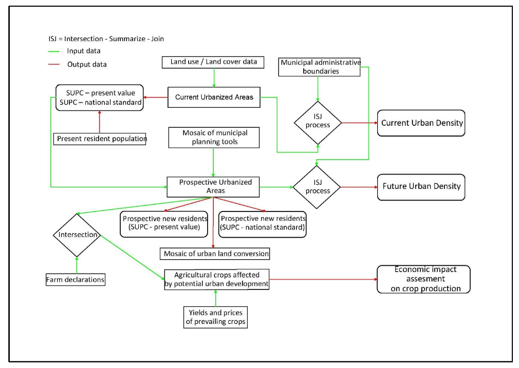
Data on land consumption comes from the ISPRA portal (Istituto Superiore per la Protezione e la Ricerca Ambientale). Values for agricultural yield come from the SIAN (Sistema Informativo Agricolo Nazionale) and price value comes from ISMEA (Istituto di Servizi per il Mercato Agricolo Alimentare) (http://www.ismeamercati.it/datiagroalimentare/indice-prezzi (accessed on 27 October 2022)). The values for the period 2015–2020 related to the crop types present in Emilia-Romagna were considered for the economic estimate of the agricultural loss. Yield values are expressed in 100 kg per hectare, prices in euros per 100 kg [11]. An analysis on the impact of transformative scenarios on agricultural production has been elaborated in GIS environment whose procedure is reported in the workflow of Figure 2. The CLC legend does not provide information about the type of cultivation present on the ground, for this reason the data of the Regional Agency, updated to 2021, for the distributions in agriculture are analyzed (https://agrea.regione.emilia-romagna.it/come-fare-per/open-data (accessed on 27 October 2022)). The data is partial (it covers 25% of the agricultural areas of the provinces), but it has allowed us to know the prevailing crops in the area and to build scenarios. In this way, yields and prices were associated, obtaining a result in euros per hectare. This is a purely economic estimate and does not correspond to the biophysical value of the service of agricultural production however conditioned by the uncertainty of yields and average prices that have been considered. The economic assessment is provided as a support, to understand the size of the environmental impact expected from the implementation of the transformation forecasts of municipal urban plans [12].
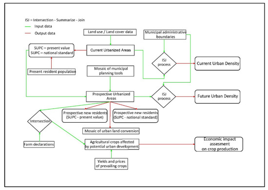
Figure 2.
Flowchart of the performed analysis.
4. Results
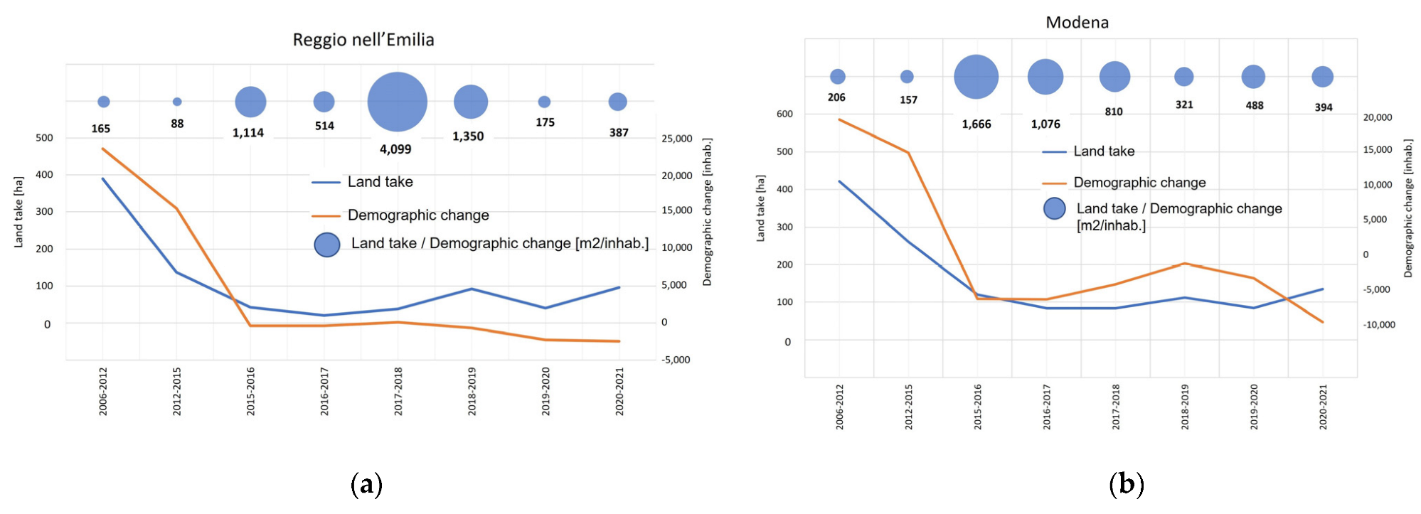
The joint analysis of the demographic dynamics and those related to land consumption has shown how the latter is substantially detached from the demographic dynamics (Figure 3). The fluctuations in the curve of the soil consumed are always positive, even in the presence of demographic decreases, reaching a maximum value of 4100 m2/inhabit for 2017–2018 period in Modena province and 1600 m2/inhabit for 2015–2016 period in Reggio nell’Emilia province.
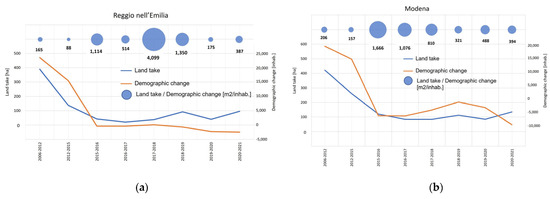
Figure 3.
Demographic changes and dynamics of land consumption between 2006 and 2021 in the territories of the investigated provinces (a) Reggio nell’Emilia province; (b) Modena province.
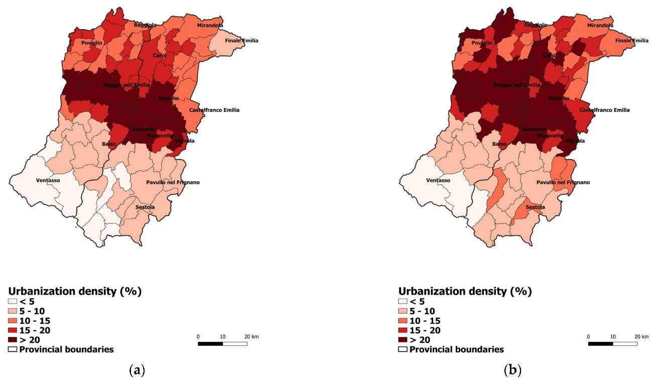
The trend of land consumption, as also witnessed by ISPRA [8], is declining, but is still far from stopping. It should also be noted that the surveyed area in the same year suffered a decline in population of over 6000 inhabitants. The above data derive from transformative actions already carried out and which have already transformed the natural soil in an irreversible way. The knowledge of the transformative forecasts present in the current plans has allowed us to outline the scenario that could derive from their complete implementation. Currently in the investigated area, there are about 750 km2 of urbanized area, most of which in the municipalities of the Province of Modena (430 km2) with a density of urbanization over the entire area of about 15%. As shown in Figure 4a, the highest values of urbanization density are concentrated along the central axis of the area studied and in the municipalities that are in the territories between the two centers and adjacent to them. In contrast, densities of urbanization (UD) are lower in the Apennine regions (UD below 5%). The framework of transformative forecasts, deriving from the summation of all the transformations that each municipality has foreseen in its plan but not yet implemented, emerges clearly from the reading of the PTM. In the study area, the municipalities plan to transform for urban purposes an additional surface of 110 km2, equally distributed between the two provinces. The full implementation of these forecasts would bring the area to a value of UD of 17%, more than 2 points more than the current condition (Figure 4b). The functional typology that affects the most is that for services (both public and private) (Table 2).
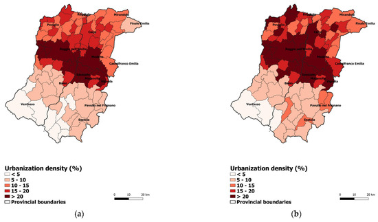
Figure 4.
(a) Current geography of the UD index in the municipalities of the provinces analyzed; (b) Configuration resulting from the complete implementation of the conversion forecasts provided for in the plans.

Table 2.
PTM forecast grouped by functional typology and province.
The urbanization density is not related to the density of population as, at the same rate, it can vary both according to the type of building and depending on the settlement model adopted (intensive or extensive).
The index Per capita Urban Surface (SUPC) has been used to analyze the transformative predictions of the plans with demographic dynamics. This index normalizes the urban area according to the number of inhabitants living in a given municipal territory. It is a type of indicator of settlement behavior and expresses in substance the endowment of the area for urban use for each inhabitant resident in the municipality. Recent studies [8,13] have shown that the value of 360 m2/inhab. of SUPC both permanently, a standard at the European level, having registered it both in Eastern and Western Europe.
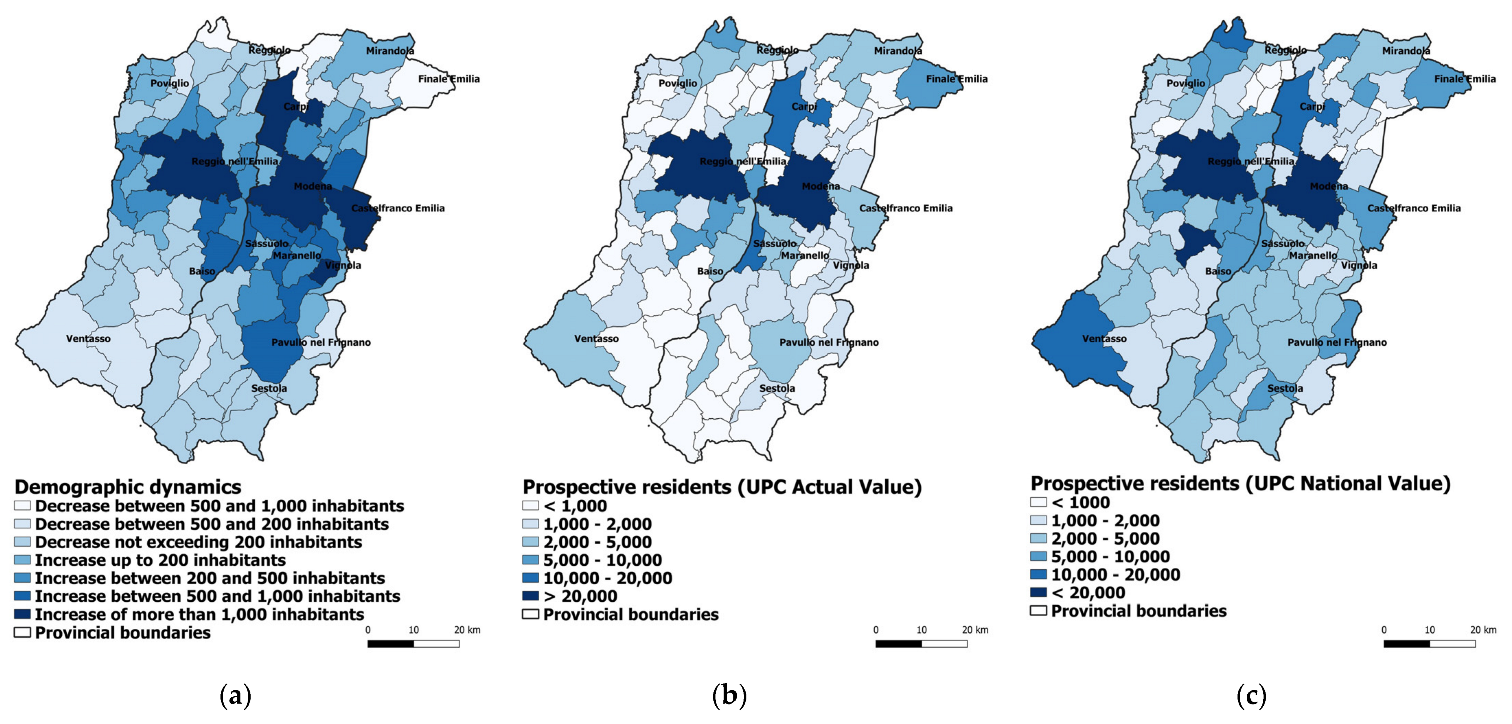
As regards the surveys conducted in this paper, this European standard together with the value of SUPC currently recorded for each municipality, have been used to understand potential residents who could be accommodated in the territory in question to fully implement the plan forecasts. Figure 5 shows the result of this operation. Figure 5a shows the recent demographic dynamics on a municipal basis recorded between 2011 and 2021 expressed in absolute value while Figure 5b,c shows potential new residents, respectively, maintaining unchanged the current value of SUPC or using instead the quoted value of national SUPC. The settlement areas, included in the plans and not yet implemented, would guarantee urban spaces in the first case for over 243,000 new residents and in the second for a further 376,000. However, recent trends show a real increase of about 10% of the figures mentioned above.
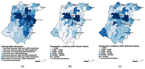
Figure 5.
(a) Real demographic dynamics; (b) potential new possible residents according to the current value of SUPC; (c) potential new possible residents according to the value of standard SUPC.
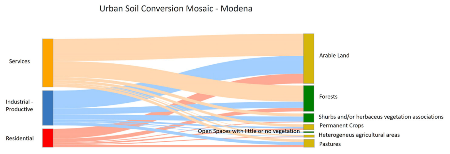
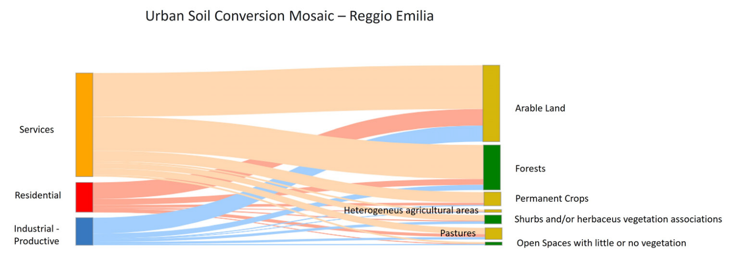
As noted above, the mosaic of urban land conversion has been reconstructed to assess the impact on the agricultural system. In detail, the land use categories were evaluated (at level II of the legend Corine Land Cover) most affected by the transformative forecasts of the current plans, divided by macro-government (Residential, Industrial-Productive, Services) for the two provinces examined (Figure 6 and Figure 7).
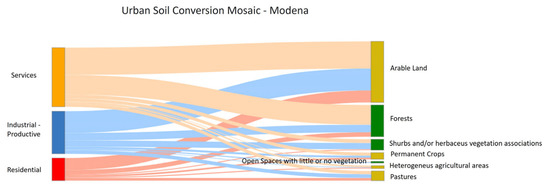
Figure 6.
Mosaic of urban conversion rebuilt for the province of Modena.
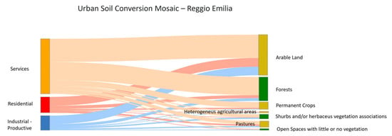
Figure 7.
Mosaic of urban conversion rebuilt for the province of Reggio Emilia.
In both analyzed cases, the macro-category of services appears to be the most impacting on natural soil (2486 ha for the province of Modena and 3716 ha for the province of Reggio Emilia). In absolute terms, the most affected soil categories are arable land and forests (Table 3).

Table 3.
Mosaic of urban conversion.
By analyzing agricultural production in detail (at level IV of the legend Corine Land Cover) it was possible to estimate the agricultural loss in economic terms. For both provinces the prevailing crops linked to the land use legend and associated with yields and prices are shown in Table 4.

Table 4.
Prevalent crop in the study area with yield and price.
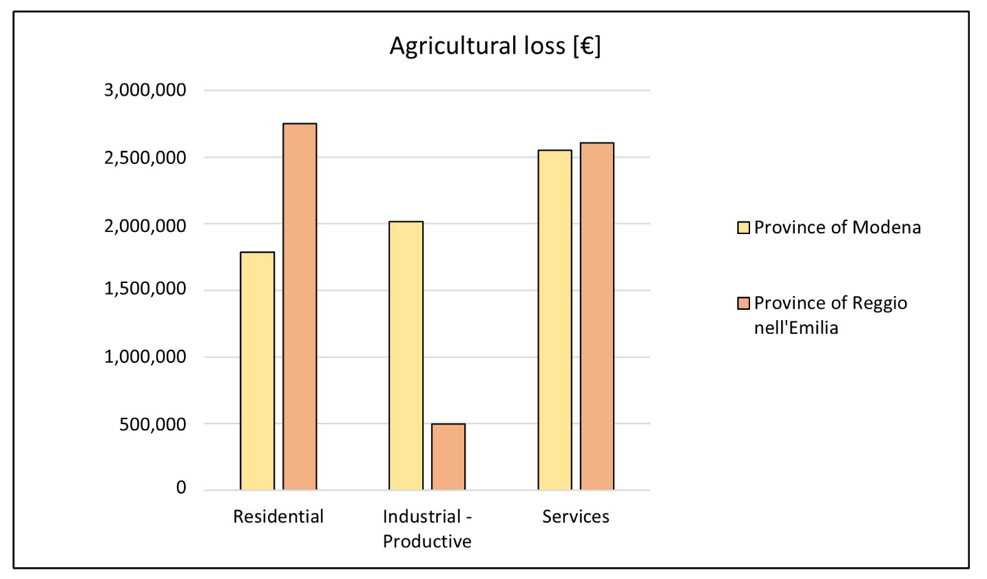
The economic loss due to agricultural production resulting from the possible implementation of the municipal urban planning plans with the hypothesis that all categories of land use at level IV are occupied by the prevailing crop, is more than 12 million euros per year. For the province of Modena, the loss is greater (6,350,000 EUR/year). In this case, the macro-category of services causes the greatest economic loss (over 2.5 M EUR/year), followed by that of services (2.0 M EUR/year) and residential areas (1.8 M EUR/year) The result for the province of Reggio nell’Emilia is different. The total hypothetical loss amounts to 5,850,000 euros per year. In this case, residential areas suffer the greatest economic loss (2.7 M EUR/year), compared to a loss of services equal to 2.6 M EUR/year. In this case, the agricultural loss destined to industrial zones—productive is relatively low (about 500,000 EUR/year) (Figure 8).
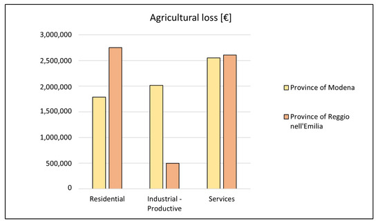
Figure 8.
Economic loss by macro category linked to the implementation of the plans.
5. Discussion
The work showed that in the territories of the provinces of Modena and Reggio nell’Emilia, an additional 110 km2 of land was affected by building forecasts, the latter being almost as large as the geographical extension of the municipality of Piacenza. Full implementation would lead to an urbanization density of the area at 17% compared to a national value of around 10% [8]. The annual agricultural loss in economic terms is over 12 MEUR. This estimate was conducted using average prices [EUR/q] referring to a period before (2015–2020) the war conflict (2022). Current prices are higher for almost all raw materials (ISMEA) and the economic loss will certainly be higher due to lower agricultural production. The InVEST (Integrated Valuation of Ecosystem Services and Trade-Offs) software, which is very common for these types of analyses, was not used to estimate agricultural production for two main reasons. First, the available land use/cover data does not have sufficient thematic detail to identify the crops included in the Crop Production model. Furthermore, the data in the above-mentioned model refer to an FAO dataset for 175 crops [14], supplemented by national and regional datasets, based on a global-scale climate model. For this reason, the analysis scenarios were formulated using the partial crop data available for the analyzed territory. The authors of [15] estimate the loss of agricultural production in the European area due to land consumption between 1990 and 2006 using CLC data whose spatial and thematic detail level does not allow for a distinction between types of cultivation. Other works have used the loss of agricultural production using the InVEST software, but without creating possible impact scenarios by analyzing the transformation forecasts of municipal urban plans and farmers’ statements on the actual crops present, as completed in this work. The authors of [16], for example, estimated the agricultural loss of wheat (considered the predominant crop in the study area) due to the installation of renewable energy sources in the Basilicata region. The authors of [17], on the other hand, analyzed the agricultural loss in the eastern part of England, using high-resolution data (Sentinel-2 at 10 m) and compared it with CLC data; research shows that more detailed data is crucial for the analysis related to agricultural production, as it allows a better estimate of the real economic loss due to the removal of this essential ecosystem service. The Italian situation is even more difficult because there is no national law on soil consumption. The worsening of the climate crisis also gives urgency for Italy and, in light of the particular conditions of fragility and criticality of the territory, making it no longer possible to postpone the definition and implementation of policies, regulations, and actions that can quickly lead to the zeroing of land consumption and the revision of the provisions of existing urban planning tools. The discourse is different at the regional level, where some regions have already moved in this direction, albeit extremely diverse on the subject and related issues (such as ecosystem services). The Emilia-Romagna Region with the enactment of the regional urban planning law 24/2017 sets itself the target of zero soil consumption to be reached by 2050 (European Union Environmental Action Programme), with a maximum limit on soil consumption of 3% of the surface area of the already urbanized territory, promoting the reuse and regeneration of urbanized territory; however, without linking this value to either the demographic aspects or even less to the economies that characterize such places, once again leaving it up to the municipalities to decide the urbanistic fate of their soil without any strategic-type vision.
6. Conclusions
The analyses on the transformative forecasts of municipal urban plans in the investigated provinces made it possible to estimate the amount of potentially usable land for urban purposes, and to quantify, albeit with simplifying but effective assumptions, the impacts produced in terms of loss of agricultural production. Knowledge of the transformative forecasts of urban plans is crucial for the identification of possible critical issues, for planning targeted corrective actions, and for the achievement of the important goals of Agenda 2030. As is often the case, the economic interest associated with urbanization is greater than that associated with other types of use. In general, urbanizing agricultural land is less costly than intervening in degraded areas or disused infrastructure [12]. Moreover, much of the revenue of the municipalities came from urbanization charges; thus, municipalities have never had a real interest in limiting land consumption, and planning for new parts of the built environment has always been sized with an eye toward expansion. In fact, analyses of actual population dynamics carried out in this research show that new urban areas are oversized compared to actual population dynamics (243,000 projected inhabitants in the case of the current SUPC value; 376,000 in the case of the national SUPC value). Among the goals of Agenda 2030 are to provide for an alignment of new land consumption with real population growth by 2030 (UN, 2015), update the forecasts of existing urban planning instruments, and give priority to the reconfiguration of urban settlement. This would be a real change of course in Italian land use planning and the economic system attached to it. It would involve addressing the issue, considering not only the real demographic dynamics but also and above all the state of occupation of the housing stock and also of its preservation by favoring redevelopment and recovery actions instead of occupying new land. This implies a multifaceted reading of the territory, attentive also to the real dynamics of real estate, but also to the values of soils the latter understood in terms of the multifaceted ecosystem services provided. Very often these topics are either poorly addressed or not at all within the plans because these instruments are exceedingly dated, and the adjustment times are often long (order of tens of years). For example, 60% of the municipalities in the province of Modena are administered with a pre-2005 urban planning instrument, sized on the basis of territorial dynamics that are certainly different from those of today. Very often, and this is even more true in the territories administered by old urban planning tools, the choices of urban planning are the result of an exercise with wide margins of discretion by the proceeding administration. Planning choices are often decontextualized by the real conditions of the territories on which they should produce effects. Such procedures are not acceptable at present, given the enormous availability of data and information and the development of technologies in the geographical field. Considering this, many Italian municipalities are moving to remove from their tools areas with urban use that remained untouched for decades, while other municipalities offer the possibility to require a change of use of the individual property with a return to agricultural/natural use. In addition to these initiatives of individual bodies, to avoid the territories being administered with plans not updated, some Italian regions have enacted laws with specific temporal validity of the planning tools. Lombardy region, for example, has provided that the municipal planning tool (the PGT or Land Government Plan) is divided into three specific documents (Rules Plan, Services Plan, and Plan Document), one of which (the Plan document) must be updated every 5 years. Such a document in fact expresses strategies, objectives, and actions through pursuing an overall picture of socio-economic and infrastructural development, considering the environmental, landscape, and cultural resources available in the territory. This measure is of primary importance because every 5 years each municipal authority has the opportunity to assess whether the strategies put in place have produced the desired results and to identify new ones if the previous ones have shown little effect In addition to the aforementioned problems related to land consumption, there are also those related to the climate crisis (reduced water availability for land irrigation, extreme events endangering crops), water pollution, and abandonment of cultivated land. In addition, reduced availability of arable land will consequently lead to an increase in commodity costs, which have already increased significantly in the past year (FAO Index). Quantifying ecosystem services in a spatially explicit way can help make decisions about the management and use of natural resources certainly more sustainable and efficient. There is not yet widespread awareness of the value of soil as a fundamental element for the quality of human life and as a nonrenewable resource [18,19]. One of the latest Draft Law of the Eighteenth Legislature of the Italian Parliament (2022) clearly exposes the above. Article 4 underlines the importance of suspending urban planning instruments and any variants with regard to provisions that provide for land consumption in agricultural areas. It also highlights the fact that the economic criterion cannot be a reason for allowing agricultural land consumption. Therefore, the provisions contained in land-use and urban planning instruments must contribute to the preservation of the natural, environmental, and landscape value of the territory and to the improvement of the environment, as a condition for the development of settlement and socioeconomic systems.
Author Contributions
Conceptualization, F.Z. and G.D.P.; methodology, F.Z, G.D.P., and C.M.; software, G.D.P.; validation, F.Z., C.M. and C.C.; formal analysis, F.Z. and G.D.P.; data curation, G.D.P. and C.M.; writing—original draft preparation, F.Z. and G.D.P.; writing—review and editing, C.M. and C.C.; visualization, C.M. and G.D.P.; supervision, F.Z. All authors have read and agreed to the published version of the manuscript.
Funding
This research received no external funding.
Conflicts of Interest
The authors declare no conflict of interest.
References
- European Union. Agri-Food Trade in 2020. Published Online 2021. Available online: https://agriculture.ec.europa.eu/system/files/2021-09/map-2021-2_en_0.pdf (accessed on 20 February 2023).
- Zullo, F.; Montaldi, C.; Romano, B. Indicators Engineering for Land Uptake and Agricultural Loss. A Study in European Countries. Curr. Urban Stud. 2021, 9, 813–830. [Google Scholar] [CrossRef]
- Chen, J. Rapid urbanization in China: A real challenge to soil protection and food security. CATENA 2007, 69, 1–15. [Google Scholar] [CrossRef]
- Satterthwaite, D.; McGranahan, G.; Tacoli, C. Urbanization and its implications for food and farming. Philos. Trans. R. Soc. B 2010, 365, 2809–2820. [Google Scholar] [CrossRef] [PubMed]
- FAO Climate Change and Food Security: Risks and Responses. Published Online 2015. Available online: https://www.fao.org/3/i5056e/i5056e.pdf (accessed on 20 February 2023).
- European Commission, Directorate General for Research and Innovation. Caring for Soil Is Caring for Life: Ensure 75% of Soils Are Healthy by 2030 for Food, People, Nature and Climate: Report of the Mission Board for Soil Health and Food; EU Publications Office: Luxembourg, 2020; Available online: https://data.europa.eu/doi/10.2777/821504 (accessed on 21 February 2023).
- European Commission, Directorate General for the Environment. Superfici Impermeabili, Costi Nascosti: Alla Ricerca di Alternative All’Occupazione e All’Impermeabilizzazione dei Suol; EU Publications Office: Luxembourg, 2013; Available online: https://data.europa.eu/doi/10.2779/21953 (accessed on 21 February 2023).
- Munafò, M. Consumo di Suolo, Dinamiche Territoriali e Servizi Ecosistemici; ISPRA: Rome, Italy, 2022. [Google Scholar]
- Fiorini, L.; Zullo, F.; Marucci, A.; Di Dato, C.; Romano, B. Planning Tool Mosaic (PTM): A platform for Italy, a country without a strategic framework. Land 2021, 10, 279. [Google Scholar] [CrossRef]
- Falcucci, A.; Maiorano, L.; Boitani, L. Changes in land-use/land-cover patterns in Italy and their implications for biodiversity conservation. Landsc. Ecol. 2007, 22, 617–631. [Google Scholar] [CrossRef]
- Autorità di Bacino Distrettuale del Fiume Po. Relazione Metodologica del Piano di Gestione del Rischio Alluvioni del Fiume Po. 2022, p. 139. Available online: https://pianoalluvioni.adbpo.it/ (accessed on 20 February 2023).
- Assennato, F.; Braca, G.; Calzolari, C.; Capriolo, A. Mappatura e Valutazione dell’Impatto del Consumo di Suolo sui Servizi Ecosistemici: Proposte Metodologiche per il Rapporto sul Consumo di Suolo. 2018. Available online: https://www.isprambiente.gov.it/files2018/pubblicazioni/rapporti/AnnessometodologicoalRapportoServiziecosistemici_2018.pdf (accessed on 20 February 2023).
- Romano, B.; Zullo, F.; Fiorini, L.; Ciabò, S.; Marucci, A. Sprinkling: An Approach to Describe Urbanization Dynamics in Italy. Sustainability 2017, 9, 97. [Google Scholar] [CrossRef]
- Monfreda, C.; Ramankutty, N.; Foley, J.A. Farming the planet: 2. Geographic distribution of crop areas, yields, physiological types, and net primary production in the year 2000: Global crop areas and yields in 2000. Glob. Biogeochem. Cycles 2008, 22, GB1022. [Google Scholar] [CrossRef]
- Gardi, C.; Panagos, P.; Van Liedekerke, M.; Bosco, C.; De Brogniez, D. Land take and food security: Assessment of land take on the agricultural production in Europe. J. Environ. Plan. Manag. 2015, 58, 898–912. [Google Scholar] [CrossRef]
- Scorza, F.; Pilogallo, A.; Saganeiti, L.; Murgante, B.; Pontrandolfi, P. Comparing the territorial performances of renewable energy sources’ plants with an integrated ecosystem services loss assessment: A case study from the Basilicata region (Italy). Sustain. Cities Soc. 2020, 56, 102082. [Google Scholar] [CrossRef]
- Rayner, M.; Balzter, H.; Jones, L.; Whelan, M.; Stoate, C. Effects of improved land-cover mapping on predicted ecosystem service outcomes in a lowland river catchment. Ecol. Indic. 2021, 133, 108463. [Google Scholar] [CrossRef]
- Boatti, G. Un Paese ben Coltivato: Viaggio nell’Italia che Torna Alla Terra e, Forse, a se Stessa; Laterza & Figli Spa: Bari, Italy, 2016; ISBN 8858106814. [Google Scholar]
- Martinelli, L. Salviamo il Paesaggio!: Manuale per Cittadini e Comitati: Come Difendere il Nostro Territorio da Cemento e Grandi Opere Inutili, 2nd ed.; Altreconomia: Milan, Italy, 2013; ISBN 978-88-6516-093-0. [Google Scholar]
Disclaimer/Publisher’s Note: The statements, opinions and data contained in all publications are solely those of the individual author(s) and contributor(s) and not of MDPI and/or the editor(s). MDPI and/or the editor(s) disclaim responsibility for any injury to people or property resulting from any ideas, methods, instructions or products referred to in the content. |
© 2023 by the authors. Licensee MDPI, Basel, Switzerland. This article is an open access article distributed under the terms and conditions of the Creative Commons Attribution (CC BY) license (https://creativecommons.org/licenses/by/4.0/).

