
Landslide Susceptibility Mapping Based on Resampling Method and FR-CNN: A Case Study of Changdu
Abstract
:1. Introduction
2. Study Area and Data
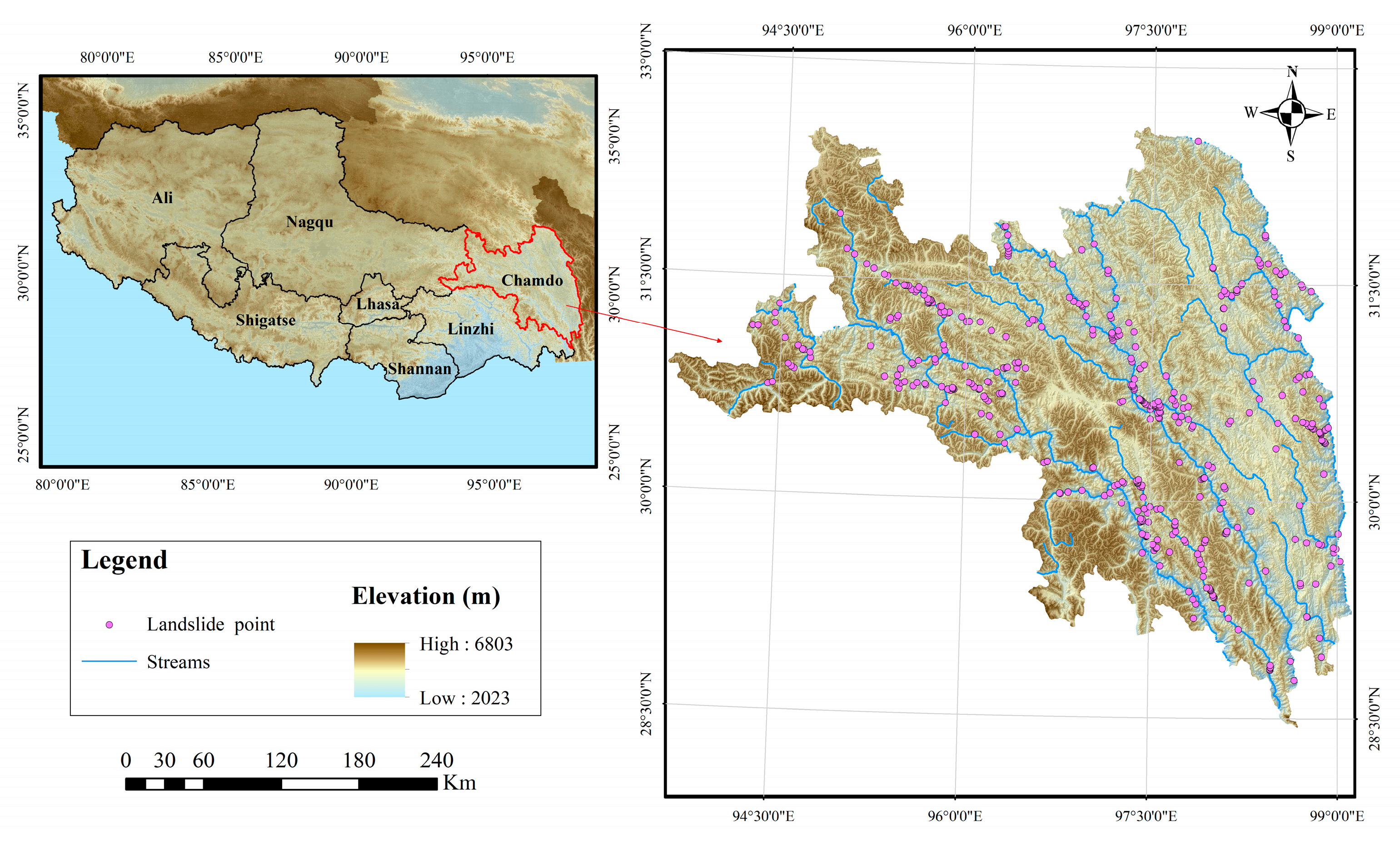
2.1. Study Area
2.2. Landslide List
2.3. Landslide Evaluation Factor
3. Methodology and Model
3.1. FR Model
3.2. Landslide Resampling Method R Model
3.3. CNN-SE Model
3.3.1. CNN Theory
3.3.2. SE-Net
3.4. Comparative Methods and Model Evaluation Indicators
4. Results
4.1. Filtering of Landslide Evaluation Factors
4.2. Influencing Factors Analyses Using FR Model
- (1)
- Stratum lithology
- (2)
- Distance from fault
- (3)
- Topography
- (4)
- Hydrological conditions
- (5)
- Human activity
- (6)
- Land cover
4.3. Mapping and Verification of Landslide Susceptibility by Deep Learning
4.4. Model Verification and Comparison
5. Discussion
6. Conclusions
- (1)
- Deep-learning structures such as CNN can analyze the relationship between complex landslide influencing factors and landslide occurrence and are practical for analyzing landslide susceptibility. The deep-learning models constructed in this study were successful in both the training and validation phases, with the CNN, CNN–SE, and ResNet models all achieving AUC values above 85%, which is higher than other traditional models including FR models and support vector machines.
- (2)
- The non-landslide samples selected by the FR-based method are more accurate and objective than those selected by the traditional buffer random sampling method. Compared with the traditional buffer random sampling method, the accuracy of the model constructed by the FR-based non-landslide sample selection method was significantly improved, the AUC was increased by 3.98–7.20%, and the obtained landslide susceptibility classification was more reasonable.
- (3)
- The resampling operation can effectively use the information of the surrounding environment of the landslide, which is conducive to the model learning deeper information and improving its generalization ability and robustness. This also helps, to a certain extent, solve the problem of insufficient CNN learning owing to inadequate samples. Compared with the model constructed from the unsampled dataset, the model constructed from the resampled sample dataset had higher accuracy, with an improved AUC of 1.34–8.82%.
Author Contributions
Funding
Informed Consent Statement
Data Availability Statement
Acknowledgments
Conflicts of Interest
References
- Crozier, M.J. Deciphering the effect of climate change on landslide activity: A review. Geomorphology 2010, 124, 260–267. [Google Scholar] [CrossRef]
- Haque, U.; Silva, P.; Devoli, G.; Pilz, J.; Zhao, B.; Khaloua, A.; Wilopo, W.; Andersen, P.; Lu, P.; Lee, J. The human cost of global warming: Deadly landslides and their triggers (1995–2014). Sci. Total Environ. 2019, 682, 673–684. [Google Scholar] [CrossRef] [PubMed]
- Turner, A.K. Social and environmental impacts of landslides. Innov. Infrastruct. Solut. 2018, 3, 70. [Google Scholar] [CrossRef]
- Pollock, W.; Wartman, J. Human vulnerability to landslides. Geohealth 2020, 4, e2020GH000287. [Google Scholar] [CrossRef]
- van Westen, C.J.; Castellanos, E.; Kuriakose, S.L. Spatial data for landslide susceptibility, hazard, and vulnerability assessment: An overview. Eng. Geol. 2008, 102, 112–131. [Google Scholar] [CrossRef]
- Furlani, S.; Ninfo, A. Is the present the key to the future? Earth-Sci. Rev. 2015, 142, 38–46. [Google Scholar] [CrossRef]
- Tsangaratos, P.; Ilia, I.; Hong, H.Y.; Chen, W.; Xu, C. Applying information theory and GIS-based quantitative methods to produce landslide susceptibility maps in Nancheng county, China. Landslides 2016, 14, 1091–1111. [Google Scholar] [CrossRef]
- Zhu, A.X.; Wang, R.; Qiao, J.; Qin, C.Z.; Chen, Y.; Jing, L.; Fei, D.; Yang, L.; Zhu, T. An expert knowledge-based approach to landslide susceptibility mapping using GIS and fuzzy logic. Geomorphology 2014, 214, 128–138. [Google Scholar] [CrossRef]
- Reichenbach, P.; Rossi, M.; Malamud, B.D.; Mihir, M.; Guzzetti, F. A review of statistically-based landslide susceptibility models. Earth-Sci. Rev. 2018, 180, 60–91. [Google Scholar] [CrossRef]
- Yalcin, A. GIS-based landslide susceptibility mapping using analytical hierarchy process and bivariate statistics in Ardesen (Turkey): Comparisons of results and confirmations. Catena 2008, 72, 1–12. [Google Scholar] [CrossRef]
- Panchal, S.; Shrivastava, A.K. Landslide hazard assessment using analytic hierarchy process (AHP): A case study of national highway 5 in India. Ain Shams Eng. J. 2021, 13, 101626. [Google Scholar] [CrossRef]
- Yan, F.; Zhang, Q.W.; Ye, S.; Ren, B. A novel hybrid approach for landslide susceptibility mapping integrating analytical hierarchy process and normalized frequency ratio methods with the cloud model. Geomorphology 2018, 327, 170–187. [Google Scholar] [CrossRef]
- Zhu, A.X.; Pei, T.; Qiao, J.P.; Chen, Y.B. A landslide susceptibility mapping approach using expert knowledge and fuzzy logic under GIS. Prog. Geogr. 2006, 25, 1–12+137. [Google Scholar]
- Regmi, N.R.; Giardino, J.R.; Vitek, J.D. Assessing susceptibility to landslides: Using models to understand observed changes in slopes. Geomorphology 2010, 122, 25–38. [Google Scholar] [CrossRef]
- Ercanoglu, M.; Gokceoglu, C. Assessment of landslide susceptibility for a landslide-prone area (North of Yenice, NW Turkey) by fuzzy approach. Environ. Geol. 2002, 41, 720–730. [Google Scholar] [CrossRef]
- Wang, Y.; Fang, Z.C.; Niu, R.Q. Landslide susceptibility analysis based on deep learning. J. Geo-Inf. Sci. 2021, 23, 2244–2260. [Google Scholar]
- Süzen, M.; Doyuran, V. Data driven bivariate landslide susceptibility assessment using geographical information systems: A method and application to Asarsuyu catchment, Turkey. Eng. Geol. 2004, 71, 303–321. [Google Scholar] [CrossRef]
- Lee, S. Application of logistic regression model and its validation for landslide susceptibility mapping using GIS and remote sensing data. Int. J. Remote Sens. 2005, 26, 1477–1491. [Google Scholar] [CrossRef]
- Pham, B.T.; Bui, D.T.; Indra, P.; Dholakia, M.B. Landslide susceptibility assessment at a part of Uttarakhand Himalaya, India using GIS—Based statistical approach of frequency ratio method. Int. J. Eng. Tech. Res. 2015, 4, 338–344. [Google Scholar] [CrossRef]
- Goyes-Peñafiel, P.; Hernandez-Rojas, A. Landslide susceptibility index based on the integration of logistic regression and weights of evidence: A case study in Popayan, Colombia. Eng. Geol. 2021, 280, 105958. [Google Scholar] [CrossRef]
- Zhao, Y.; Wang, R.; Jiang, Y.; Liu, H.; Wei, Z. GIS-based logistic regression for rainfall-induced landslide susceptibility mapping under different grid sizes in Yueqing, Southeastern China. Eng. Geol. 2019, 259, 105147. [Google Scholar] [CrossRef]
- Blahut, J.; Westen, C.; Sterlacchini, S. Analysis of landslide inventories for accurate prediction of debris-flow source areas. Geomorphology 2010, 119, 36–51. [Google Scholar] [CrossRef]
- Merghadi, A.; Ali, P.; Dou, J.; Whiteley, J.; Binh, T.P.; Dieu, T.B.; Avtar, R.; Abderrahmane, B. Machine learning methods for landslide susceptibility studies: A comparative overview of algorithm performance. Earth-Sci. Rev. Int. Geol. J. Bridg. Gap Between Res. Artic. Textb. 2020, 207, 103225. [Google Scholar] [CrossRef]
- Huang, Y.; Zhao, L. Review on landslide susceptibility mapping using support vector machines. Catena 2018, 165, 520–529. [Google Scholar] [CrossRef]
- Arabameri, A.; Pradhan, B.; Rezaei, K.; Lee, C.H. Assessment of landslide susceptibility using statistical- and artificial intelligence-based FR–RF integrated model and multiresolution DEMs. Remote Sens. 2019, 11, 999. [Google Scholar] [CrossRef] [Green Version]
- Bui, D.T.; Pradhan, B.; Lofrnan, O.; Revhaug, I.; Dick, O.B. Landslide susceptibility assessment in the Hoa Binh province of Vietnam: A comparison of the Levenberg–Marquardt and Bayesian regularized neural networks. Geomorphology 2012, 171–172, 12–29. [Google Scholar] [CrossRef]
- Zhu, X.X.; Tuia, D.; Mou, L.; Xia, G.-S.; Zhang, L.; Xu, F.; Fraundorfer, F. Deep learning in remote sensing: A comprehensive review and list of resources. IEEE Geosci. Remote Sens. Mag. 2017, 5, 8–36. [Google Scholar] [CrossRef] [Green Version]
- Bragagnolo, L.; Rezende, L.R.; da Silva, R.V.; Grzybowski, J.M.V. Convolutional neural networks applied to semantic segmentation of landslide scars. Catena 2021, 201, 105189. [Google Scholar] [CrossRef]
- Zhou, X.; Zhou, W.; Fu, X.; Hu, Y.; Liu, J.L. MDVT: Introducing mobile three-dimensional convolution to a vision transformer for hyperspectral image classification. Int. J. Digit. Earth 2023, 16, 1469–1490. [Google Scholar] [CrossRef]
- Nhu, V.H.; Hoang, N.D.; Nguyen, H.; Thao, N.; Bui, D.T. Effectiveness assessment of Keras based deep learning with different robust optimization algorithms for shallow landslide susceptibility mapping at tropical area. Catena 2020, 188, 104458. [Google Scholar] [CrossRef]
- Bui, D.T.; Tsangaratos, P.; Nguyen, V.T.; Liem, N.V.; Trinh, P.T. Comparing the prediction performance of a deep learning neural network model with conventional machine learning models in landslide susceptibility assessment. Catena 2020, 188, 104426. [Google Scholar] [CrossRef]
- Fang, Z.C.; Wang, Y.; Peng, L.; Hong, H.Y. Integration of convolutional neural network and conventional machine learning classifiers for landslide susceptibility mapping. Comput. Geosci. 2020, 139, 104470. [Google Scholar] [CrossRef]
- Wang, Y.; Fang, Z.C.; Hong, H.Y. Comparison of convolutional neural networks for landslide susceptibility mapping in Yanshan county, China. Sci. Total Environ. 2019, 666, 975–993. [Google Scholar] [CrossRef] [PubMed]
- Yi, Y.; Zhang, Z.; Zhang, W.; Jia, H.; Zhang, J. Landslide susceptibility mapping using multiscale sampling strategy and convolutional neural network: A case study in Jiuzhaigou region. Catena 2020, 195, 104851. [Google Scholar] [CrossRef]
- Hong, H.Y.; Miao, Y.M.; Liu, J.Z.; Zhu, A.X. Exploring the effects of the design and quantity of absence data on the performance of random forest-based landslide susceptibility mapping. Catena 2019, 176, 45–64. [Google Scholar] [CrossRef]
- Wang, C.H.; Lin, Q.G.; Wang, L.B.; Jiang, T.; Su, B.D.; Wang, Y.J.; Mondal, S.K.; Huang, J.L.; Wang, Y. The influences of the spatial extent selection for non-landslide samples on statistical-based landslide susceptibility modelling: A case study of Anhui province in China. Nat. Hazards 2022, 112, 1967–1988. [Google Scholar] [CrossRef]
- Erener, A.; Sivas, A.A.; Selcuk-Kestel, A.S.; Düzgün, H. Analysis of training sample selection strategies for regression-based quantitative landslide susceptibility mapping methods. Comput. Geosci. 2017, 104, 62–74. [Google Scholar] [CrossRef]
- Qiao, H.; Zhou, Y.; Wang, S.X.; Wang, F.T. Machine learning and fractal theory models for landslide susceptibility mapping: Case study from the Jinsha river basin. Geomorphology 2020, 351, 106975. [Google Scholar] [CrossRef]
- Zhou, M.D.; Lü, T.Y.; Zhang, Y.S.; Ruan, A.G. The geological structure background and the crustal structure in the northeastern margin of the Qinghai-Tibetan Plateau. Acta Seismol. Sin. 2000, 13, 687–697. [Google Scholar] [CrossRef]
- Guo, C.B.; Zhang, Y.S.; Jiang, L.W.; Shi, J.S.; Meng, W.; Du, Y.B. Discussion on the environmental and engineering geological problems along the Sichuan-Tibet railway and its adjacent area. Geoscience 2017, 31, 877–889. [Google Scholar]
- Bai, Y.; Ni, H.; Ge, H. Advances in research on the geohazard effect of active faults on the southeastern margin of the Tibetan plateau. J. Geomech. 2019, 25, 1116–1128. [Google Scholar] [CrossRef]
- Cao, P.; Li, Y.S.; Li, Z.L.; Ba, R.J.; Zhang, S.T. Geological structure characteristics and genetic mechanism of Baige landslide slope in Changdu, Tibet. Earth Sci. 2021, 46, 3397–3409. [Google Scholar] [CrossRef]
- Engler, R.; Guisan, A.; Rechsteiner, L. An improved approach for predicting the distribution of rare and endangered species from occurrence and pseudo-absence data. J. Appl. Ecol. 2004, 41, 263–274. [Google Scholar] [CrossRef]
- Liu, J.; Li, S.; Chen, T. Landslide susceptibility assessment based on optimized random forest model. Geomat. Inf. Sci. Wuhan Univ. 2018, 43, 1085–1091. [Google Scholar]
- Tian, S.; Zhang, S.; Tang, Q.; Fan, X. Comparative study of landslide susceptibility assessment based on different evaluation units. J. Nat. Disasters 2019, 28, 137–145. [Google Scholar]
- Yilmaz, I. Landslide susceptibility mapping using frequency ratio, logistic regression, artificial neural networks and their comparison: A case study from Kat landslides (Tokat—Turkey). Comput. Geosci. 2009, 35, 1125–1138. [Google Scholar] [CrossRef]
- Guo, C.; Montgomery, D.R.; Zhang, Y.; Wang, K.; Yang, Z. Quantitative assessment of landslide susceptibility along the Xianshuihe fault zone, Tibetan plateau, China. Geomorphology 2015, 248, 93–110. [Google Scholar] [CrossRef]
- Lee, S.; Min, K. Statistical analysis of landslide susceptibility at Yongin, Korea. Environ. Geol. 2001, 40, 1095–1113. [Google Scholar] [CrossRef]
- Lee, S.; Pradhan, B. Probabilistic landslide hazards and risk mapping on Penang island, Malaysia. J. Earth Syst. Sci. 2006, 115, 661–672. [Google Scholar] [CrossRef] [Green Version]
- Zhao, W.; Du, S. Learning multiscale and deep representations for classifying remotely sensed imagery. ISPRS J. Photogramm. Remote Sens. 2016, 113, 155–165. [Google Scholar] [CrossRef]
- Tobler, W.R. A computer movie simulating urban growth in the Detroit region. Econ. Geogr. 1970, 46, 234–240. [Google Scholar] [CrossRef]
- Zhou, F.Y.; Jin, L.P.; Dong, J. Review of convolutional neural network. Chin. J. Comput. 2017, 40, 1229–1251. [Google Scholar] [CrossRef]
- Wu, X.L.; Yang, J.Y.; Niu, R.Q. A landslide susceptibility assessment method using smote and convolutional neural network. Geomat. Inf. Sci. Wuhan Univ. 2020, 45, 1223–1232. [Google Scholar] [CrossRef]
- Jie, H.; Li, S.; Gang, S. Squeeze-and-excitation networks. In Proceedings of the 2018 IEEE/CVF Conference on Computer Vision and Pattern Recognition, Salt Lake City, UT, USA, 18–23 June 23 2018; pp. 7132–7141. [Google Scholar] [CrossRef] [Green Version]
- Zhao, L.P.; Yuan, X.; Zhu, C.; Zhao, X.Q.; Yang, S.H.; Liang, P. Research on residual networks for image classification. Comput. Eng. Appl. 2020, 56, 9–19. [Google Scholar] [CrossRef]
- Qin, X.; Huang, C.C.; Shi, Y.; Liao, Z.Q.; Liang, X.Y. Research progress of image classification based on convolutional neural network. Guangxi Sci. 2020, 27, 587–599. [Google Scholar] [CrossRef]
- Pham, B.T.; Prakash, I.; Singh, S.K.; Shirzadi, A.; Shahabi, H.; Tran, T.-T.; Bui, D.T. Landslide susceptibility modeling using reduced error pruning trees and different ensemble techniques: Hybrid machine learning approaches. Catena 2019, 175, 203–218. [Google Scholar] [CrossRef]
- Jain, I.; Jain, V.K.; Jain, R. Correlation feature selection based improved-binary particle swarm optimization for gene selection and cancer classification. Appl. Soft Comput. 2017, 62, 203–215. [Google Scholar] [CrossRef]
- Wu, X.L.; Ren, F.; Niu, R.Q. Spatial intelligent prediction of landslide hazard based on multi-source data in three gorges reservoir area. Geomat. Inf. Sci. Wuhan Univ. 2013, 38, 963–968. [Google Scholar] [CrossRef]
- Wang, S.B.; Zhuang, J.Q.; Zheng, J.; Mu, J.Q.; Wang, Y.; Fu, Y.T. Landslide susceptibility evaluation based on deep learning along Kangding-Litang section of Sichuan-Tibet railway. J. Eng. Geol. 2022, 30, 908–919. [Google Scholar] [CrossRef]
- Hong, H.; Liu, J.; Bui, D.T.; Pradhan, B.; Acharya, T.D.; Pham, B.T.; Zhu, A.X.; Chen, W.; Ahmad, B.B. Landslide susceptibility mapping using j48 decision tree with Adaboost, bagging and rotation forest ensembles in the Guangchang area (China). Catena 2018, 163, 399–413. [Google Scholar] [CrossRef]
- Guo, Z.Z.; Yin, K.L.; Huang, F.M.; Fu, S.; Zhang, W. Evaluation of landslide susceptibility based on landslide classification and weighted frequency ratio model. Chin. J. Rock Mech. Eng. 2019, 38, 287–300. [Google Scholar] [CrossRef]
- Shahabi, H.; Hashim, M. Landslide susceptibility mapping using GIS-based statistical models and remote sensing data in tropical environment. Sci. Rep. 2015, 5, 9899. [Google Scholar] [CrossRef] [PubMed] [Green Version]
- Löbmann, M.T.; Geitner, C.; Wellstein, C.; Zerbe, S. The influence of herbaceous vegetation on slope stability—A review. Earth-Sci. Rev. 2020, 209, 103328. [Google Scholar] [CrossRef]


| 1st-Order Factor | 2nd-Order Factor | Data Source |
|---|---|---|
| Geological conditions and topography | Lithology | http://geocloud.cgs.gov.cn (6 April 2022) |
| Distance to faults | ||
| Elevation | http://dwtkns.com/srtm30m/ (5 April 2022) | |
| Slope | 30 m SRTM DEM | |
| Aspect | ||
| Profile curvature | ||
| Plane curvature | ||
| Degree of relief | ||
| Surface roughness | ||
| Hydrological conditions | Distance to streams | https://www.webmap.cn (1 April 2022) |
| the topographic wetness index (TWI) | 30 m SRTM DEM | |
| Human activities | Distance to roads | https://www.webmap.cn (1 April 2022) |
| Land-use | http://www.globallandcover.com/ (2 April 2022) | |
| Surface cover | the Normalized Difference Vegetation Index (NDVI) | GEE (Landsat 8 OLI) |
| Soil | 1:1 million Soil map of the People’s Republic of China |
| Lithology Classification | Description |
|---|---|
| A | Other lithology |
| B | Hard rock intrusive formations |
| C | Soft, thinly bedded sand, gravel and mudstone formations |
| D | Soft and hard detailed laminated, thinly bedded sand, sand and gravel, mudstone formations |
| E | Hard, harder lava rock formations |
| F | Clay and sandy soils |
| G | Harder laminated, thinly bedded medium to shallow metamorphic formations |
| H | Thinly laminated schistose sand shale formations with soft and hard intervals |
| I | Hard, harder laminated tuffs, dacite, dolomite formations |
| J K | Soft and hard interbedded carbonates, clastic rock formations |
| Permafrost | |
| L | Hard, more rigidly laminated, thinly bedded carbonate formations |
| Susceptibility Class | FR-CNN-Resample | FR-CNN-SE-Resample | FR-ResNet-Resample |
|---|---|---|---|
| very low | 47.68 | 45.47 | 56.38 |
| low | 18.79 | 18.98 | 13.31 |
| moderate | 10.49 | 13.25 | 6.91 |
| high | 7.93 | 7.95 | 5.11 |
| very high | 15.1 | 14.35 | 18.29 |
| Model | Sampling Method | Precision | Accuracy (%) | Recall | MCC | F1 Score |
|---|---|---|---|---|---|---|
| CNN | Random | 0.7903 | 81.10 | 0.8167 | 0.6219 | 0.8033 |
| FR | 0.8796 | 86.05 | 0.8293 | 0.7217 | 0.8537 | |
| Random-resample | 0.9189 | 91.05 | 0.8939 | 0.8209 | 0.9063 | |
| FR-resample | 0.9217 | 92.98 | 0.9395 | 0.8597 | 0.9305 | |
| CNN-SE | Random | 0.8205 | 82.28 | 0.8000 | 0.6443 | 0.8101 |
| FR | 0.8823 | 90.52 | 0.9312 | 0.8118 | 0.9061 | |
| Random-resample | 0.9187 | 93.15 | 0.9420 | 0.8633 | 0.9302 | |
| FR-resample | 0.9617 | 94.38 | 0.9246 | 0.8883 | 0.9428 | |
| ResNet | Random | 0.8071 | 86.61 | 0.9417 | 0.743 | 0.8692 |
| FR | 0.9577 | 92.72 | 0.8910 | 0.8561 | 0.9231 | |
| Random-resample | 0.9632 | 95.74 | 0.9483 | 0.9148 | 0.9557 | |
| FR-resample | 0.9769 | 97.01 | 0.9632 | 0.9404 | 0.9700 |
Disclaimer/Publisher’s Note: The statements, opinions and data contained in all publications are solely those of the individual author(s) and contributor(s) and not of MDPI and/or the editor(s). MDPI and/or the editor(s) disclaim responsibility for any injury to people or property resulting from any ideas, methods, instructions or products referred to in the content. |
© 2023 by the authors. Licensee MDPI, Basel, Switzerland. This article is an open access article distributed under the terms and conditions of the Creative Commons Attribution (CC BY) license (https://creativecommons.org/licenses/by/4.0/).
Share and Cite
Qin, Z.; Zhou, X.; Li, M.; Tong, Y.; Luo, H. Landslide Susceptibility Mapping Based on Resampling Method and FR-CNN: A Case Study of Changdu. Land 2023, 12, 1213. https://doi.org/10.3390/land12061213
Qin Z, Zhou X, Li M, Tong Y, Luo H. Landslide Susceptibility Mapping Based on Resampling Method and FR-CNN: A Case Study of Changdu. Land. 2023; 12(6):1213. https://doi.org/10.3390/land12061213
Chicago/Turabian StyleQin, Zili, Xinyao Zhou, Mengyao Li, Yuanxin Tong, and Hongxia Luo. 2023. "Landslide Susceptibility Mapping Based on Resampling Method and FR-CNN: A Case Study of Changdu" Land 12, no. 6: 1213. https://doi.org/10.3390/land12061213