Abstract
Resilience evaluation is an important foundation for sustainable rural development. Taking the 57 counties in Guangdong province as examples, this study used the CRITIC method to construct a comprehensive evaluation index system for rural resilience and identified the main influencing factors and their spatial heterogeneity on the basis of the geographical detector method and multiscale geographically weighted regression. The results showed that: (1) Most of the counties in Guangdong province had medium or higher values of comprehensive resilience, and the high-value areas were mainly located in the Pearl River Delta region. (2) The comprehensive resilience and each dimensional resilience measure exhibited significant positive spatial correlations. (3) The geographic detector results showed that the per capita gross regional product and the number of industries above the scale were the main influencing factors for rural resilience, and each influencing factor had an enhanced effect after interaction. (4) The effect of each factor on rural resilience demonstrated spatial heterogeneity. Specifically, the proportion of secondary and tertiary industries showed negative effects in some counties in eastern and northern Guangdong and positive effects in other counties.
1. Introduction
In recent years, the issue of urban–rural development imbalance in developing countries has gradually become apparent due to external disturbances, such as natural disasters, rapid urbanization, and labor loss [1,2]. The internal structure and functions of rural areas are also gradually undergoing changes. In response to external shocks and internal demands, some villages are experiencing problems, such as landscape fragmentation [3], rural hollowing [4], and aging [5], making the vulnerability of rural areas increasingly significant [6]. Therefore, implementing a multidimensional development model, enhancing the resilience of rural systems, and promoting rural revitalization and sustainable development have become popular topics of concern.
Resilience is the ability of a system to resist, absorb, adapt, and recover from disturbances that occur slowly or rapidly, and it is a dynamic system property [7]. Rural resilience refers to the ability of rural areas as dynamic social-ecological systems to adapt to changing external environments to maintain a satisfactory standard of living, emphasizing that rural systems are persistent, adaptive, and transformative [8,9]. Compared with urban resilience studies, which focus on economic and social factors, rural resilience studies focus on agricultural, ecological, and social factors that are closely related to agricultural development. On the basis of the “disturbance-response” logic, resilience theory explains the complex interaction between rural systems and the external environment and proposes corresponding practical solutions; thus, rural resilience has become a new perspective for studying rural problems.
Rural resilience evaluation provides an effective way of assessing the current situation and the potential for development, distinguishing the grade of rural resilience, exploring the causes of problems, and guiding practice with theory. The relevant evaluation index system mainly focuses on four aspects of resilience: components, basic characteristics, individual perception, and evolutionary processes [10,11,12]. Among them, the components emphasize the diversity of rural natural capital, productive capital, human capital, and social capital and the capacity of a village to acquire each type of capital. Basic characteristics refer to the capabilities or systemic characteristics of resilient villages embodied in different stages of resilience, such as robustness, adaptability, and transformational capacity. Individual perceptions include community beliefs, emergency preparation, collective efficacy, leadership, and social trust. Finally, the resilience processes focus on the three stages of resistance, absorption, and recovery of rural resilience development. For example, Wilson et al. combined social, cultural, natural, economic, and political factors to assess the level of resilience of rural communities [13]. Sánchez et al. combined economic, social, and human and natural capital to evaluate the resilience of rural areas in southern Spain [14]. Li et al. developed an analytical framework for integrating the resources, morphology, and function of rural system resilience [15]. Li introduced the “pressure–state–response” model to evaluate the economic, social, ecological, and engineering resilience of rural China from 2000 to 2018 [6]. In the analysis of relevant drivers, through factors such as natural resources and socioeconomic factors, rural internal and external assistance dynamics jointly drive rural development [16,17]. Physical geographical conditions are the most basic factors affecting rural resilience level [15]. Villages with better geographical conditions and resource endowments are less affected by environmental disturbances and usually have higher resilience. The level of economic and social development provides material security for rural development and can help protect against external risks. Moreover, the focus has gradually shifted from natural disasters to human disturbances, emphasizing the role of economic, social, and cultural factors in shaping rural resilience [18,19,20,21], such as industrial development [19], social connections [22], rural policies [19], and government input and governance effectiveness [13,23]. For example, Huang et al. found that the main causes of rural resilience variations could be attributed to the diverse economic development modes, as well as differing degrees of land market development and government regulation [8]. Social connections are also critical to resilience, as they regulate the relationships between the economic, cultural, and environmental components of rural communities [13]. Research has found that positive intergenerational relationships enhance rural resilience from the sociocultural perspective [24]. Overall, the various factors affecting rural resilience are nonlinear and interlinked in complex and often cumulative ways [25].
China is the largest developing country in the world and has the largest agricultural population. Despite the current rapid urbanization process, rural development still faces problems, such as a weak economic foundation, an aging population, and uncoordinated urban–rural development [26]. Thus, the Chinese government formulated the “Rural Revitalization Strategy” in 2017, and in September 2018, the country issued the “Strategic Plan for Rural Revitalization (SPRR) (2018–2022)”, which prioritizes the development of agriculture and rural areas according to the general requirements of thriving businesses, pleasant living environments, social etiquette and civility, effective governance, and prosperity to enhance the competitiveness and resilience level of sustainable rural development [27,28]. Guangdong province, as a large, economically developed province in the coastal region of China, has a complex and diverse landscape type, including mountains, hills, terraces, and plains, and the overall topography is high in the north and low in the south. The natural resource endowments and economic and social development levels of different regions vary greatly, and the development of rural industries in Guangdong shows a distinct trend of diversification and regional heterogeneity. The rapid development of the Pearl River Delta has brought economic, social, and artificial environmental disturbances to rural development in less economically developed regions and is a typical case area for studying rural development in the context of unbalanced urban–rural development. In addition, Guangdong province is located on the coast and is also influenced by the natural environment. Therefore, in the context of unbalanced regional urban–rural development, Guangdong province was chosen as the study area to analyze its rural resilience-related issues in order to mitigate the impact on rural development due to external perturbations, such as rapid urbanization, labor force loss, and natural disasters.
In general, although rich explorations of rural resilience have been carried out, the existing studies focus on the comprehensive evaluation of rural resilience, and their research frameworks are not strongly related to the overall objectives proposed in the SPRR [29], resulting in the failure to form a systematic and operable evaluation system to guide rural development. In addition, in terms of the driving factors, authors have often used the exploratory spatial data analysis (ESDA) methods [30], the geographical detector-based model [16,31,32], regression analysis [33], and other methods to analyze the independent forces of different factors, but the interaction between and the multiscale spatial heterogeneity of resilience’s influencing factors have yet to be intensively analyzed in a quantitative manner. The methods in existing studies were mostly used to analyze the independent effects of different factors at a global scale [29]. Although GWR can be used to analyze the heterogeneity in the roles of each influence factor locally, the bandwidth setting for the influence factors is uniform. MGWR is an improvement of GWR that allows for a differentiated bandwidth for each variable. This differentiated bandwidth reflects the scale range of the spatially stable effects of each variable. Therefore, MGWR can more realistically reflect the spatial variation for each influence factor and their scale differences. In order to establish a systematic theoretical framework for resilience evaluation and provide a management basis for the implementation of the SPRR, this study constructed a comprehensive rural resilience evaluation index system using the long-term goal of rural revitalization and the components of resilience and identified and analyzed the global forces, interaction forces, and spatial heterogeneity characteristics of the driving factors related to rural resilience.
2. Materials and Methods
2.1. Data Source and Processing
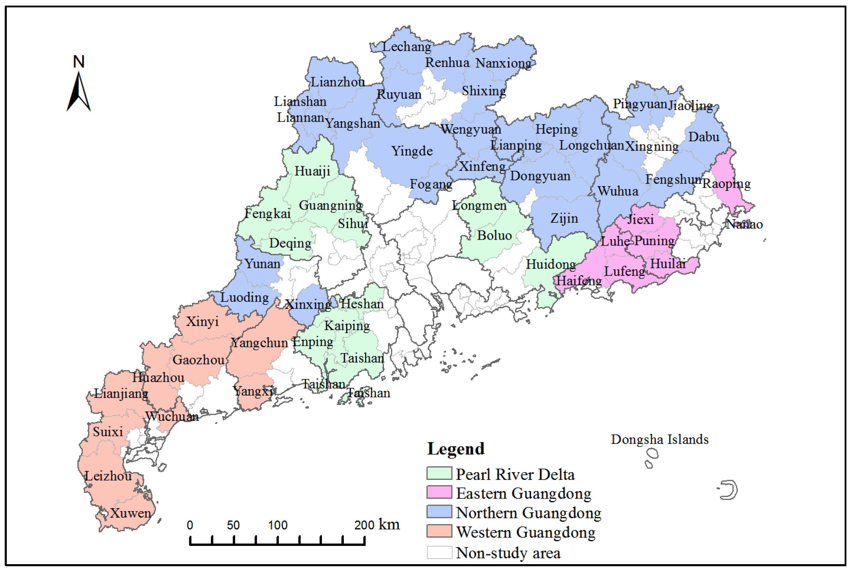
Guangdong province is located in the southernmost part of mainland China. It consists of 21 prefecture-level cities, including 65 municipal districts, 20 county-level cities, 34 counties, and 3 autonomous counties, and is divided into 4 zones; namely, the Pearl River Delta (PRD), northern Guangdong, western Guangdong, and eastern Guangdong.
The data required mainly included socioeconomic development statistics and spatial vector data. The statistics were mainly from the 2021 China County Statistical Yearbook (County and City Volume), the 2021 Guangdong Rural Statistical Yearbook, the main data bulletin of the Third National Agricultural Census for each city, the bulletin of the Seventh National Population Census, statistical yearbooks, and the statistical bulletin data relating to the national economic and social development of each place. The spatial vector data were mainly from the 2021 1:1,000,000 national basic geographic database (https://www.webmap.cn/commres.do?method=result100W, accessed on 20 October 2022), and the DEM data were ASTER GDEM 30 m resolution data (https://www.gscloud.cn/, accessed on 20 October 2022). Considering the strong influence of economic and social conditions on rural resilience, the urbanization level of municipal districts is generally high. This study took counties as the spatial research unit, and the study area comprised the 57 county-level units in Guangdong province, excluding the municipal districts of prefecture-level cities (as shown in Figure 1).
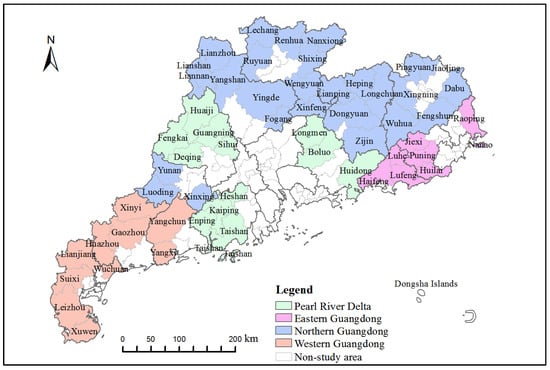
Figure 1.
Scope of the study area.
2.2. Methodology
2.2.1. Rural Resilience Analysis Framework
This study attempted to answer the following questions: (1) What are the spatial distribution characteristics of rural resilience levels in each county of Guangdong province? (2) What are the main factors affecting rural resilience? In order to analyze the above questions, the rural resilience analysis framework was constructed.
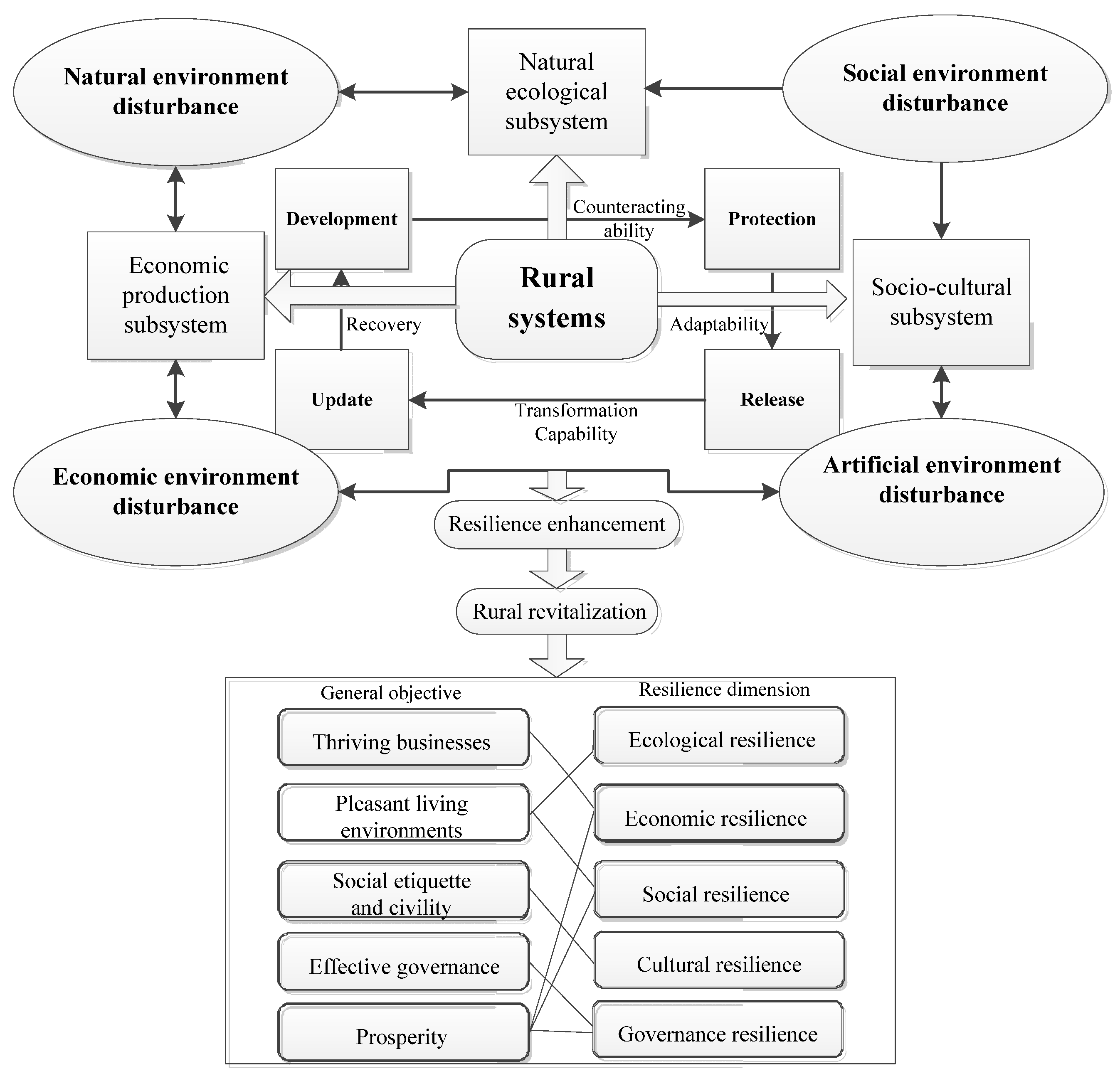
Rural territorial systems consist of a natural ecological component, economic production, and sociocultural subsystems, and enhancing their resilience helps promote high-quality and sustainable rural development. Rural resilience provides a dynamic framework for analyzing rural development processes, while the planning goal of a rural revitalization strategy indicates the ideal outcome of rural resilience evolution. Enhancing rural resilience is a necessary condition and important path for achieving rural revitalization [29,34].
Based on the framework of the community resilience concept [35,36], this study constructed a rural resilience evaluation system with five dimensions comprising ecological resilience, economic resilience, social resilience, cultural resilience, and governance resilience based on the structural elements of rural territorial systems (Figure 2). In terms of the selection of specific indicators, the evaluation index system for rural resilience was constructed from the linkage between process and goal based on the objectives of the SPRR (thriving businesses, pleasant living environments, social etiquette and civility, effective governance, and prosperity) and the common indicators widely used in the reference literature.
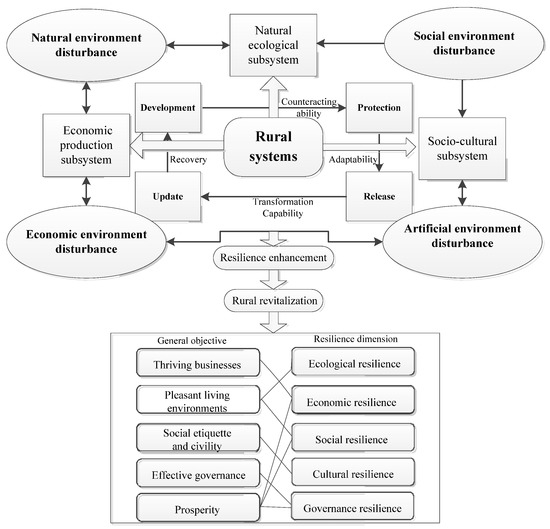
Figure 2.
Rural resilience analysis framework.
2.2.2. Rural Resilience Evaluation Index System
Considering the feasibility of indicator data acquisition, the evaluation index system for rural resilience was constructed by screening the corresponding resilience indicators from among the 22 indicators in the strategic plan for rural revitalization and adding widely used indicators from relevant similar studies (as shown in Table 1). The specific indicators are described as follows:

Table 1.
Rural resilience evaluation index system.
- (1)
- Ecological resilience is mainly reflected by the natural background characteristics of a region and the level of environmental management. Therefore, the greening coverage rates of villages and the percentages of villages that treat domestic waste and sewage were selected from the SPRR. In addition, as the natural background of rural areas is mainly represented by arable land and mainly used for cultivation, the proportion of arable land and the intensity of pesticide and chemical fertilizer application were added with reference to the relevant literature. Overall, five indicators were included: village greening coverage, proportion of cultivated land area, intensity of pesticide and chemical fertilizer application, proportion of centralized treatment of village domestic garbage, and proportion of centralized treatment of village domestic sewage;
- (2)
- Economic resilience is mainly reflected by the production capacity of various agricultural and non-agricultural economic activities, the level of human resources, and the income of residents. Production capacity includes production capital input, industrial specialization, and diversification of economic activities. Considering the data availability, the indicators from the SPRR included grain comprehensive production capacity, agricultural labor productivity, and the ratio of agricultural processing output to total agricultural output, and the gross domestic product per capita and economic diversification indicators were selected with reference to the relevant literature. For the human resources level, the rural labor force as a proportion of the rural population indicator was selected from the relevant literature. For residents’ income, the Engel coefficient of the rural residents was selected from the indicators in the SPRR and the per capita disposable income from the reference literature;
- (3)
- Social resilience is mainly reflected by livelihood protection and facility and service conditions, social network connection, and social investment. The indicators from the SPRR included the penetration rate for rural running water, the proportion of established villages with hardened roads, and the penetration rate for rural sanitary toilets, while the Internet penetration rate, medical facility configuration, doctor coverage, and per capita public expenditure indicators used in the reference literature were selected;
- (4)
- Cultural resilience is mainly reflected by the provision of cultural public facilities, the cohesiveness and civility of social networks, the education level of the population, and the government’s financial investment in education and culture. The coverage rate for village comprehensive cultural service centers and the percentage of civilized villages and townships above the county level were selected from among the indicators from the SPRR, and the percentage of financial expenditure on education, science and technology, culture, sports, and media and the average education level indicators used in the reference literature were also selected;
- (5)
- Government governance resilience is mainly reflected by the level of government governance input and management. Given that the data for related indicators are not yet covered in the national agricultural census, two indicators (namely, the degree of urban–rural integrated governance and the degree of income disparity between urban and rural residents) were selected from the references to reflect the effectiveness of the system and the happiness of people.
2.2.3. Rural Resilience Evaluation Model
- Standardization of indicator data
The indicators were divided into positive and negative indicators and normalized using the following equations:
Positive indicators:
Negative indicators:
where xij represents the original data, yij represents the normalized data, max(xij) is the maximum value of the corresponding indicator, and min(xij) is the minimum value of the corresponding indicator.
- 2.
- Determination of indicator weights
The CRITIC objective assignment method considers the standard deviation and potential for conflict as two important factors in determining the weight of an indicator [44]. A high standard deviation and great potential for conflict indicate that the indicator responds to a large amount of system information, and the corresponding weight is high. This method considers the degree of variability for the values for each indicator and the influence of the correlation between indicators on the weights and is, therefore, more suitable than the ordinary entropy method for evaluating the level of rural resilience, which is influenced by multiple factors and the interaction between them. The formula for the CRITIC method is as follows:
where Ci is the information entropy of indicator i, σi is the standard deviation of indicator i, rij is the correlation coefficient between indicator i and other indicators, and Wi is the weight of indicator i.
Finally, the weighted summation method was adopted to calculate the comprehensive rural resilience score for each evaluation object j. The specific formula is as follows:
In the formula, Sj is the comprehensive rural resilience score for evaluation object j, and yij is the standardized value of the corresponding indicator for evaluation object j.
2.2.4. Geographical Detector Method
The geographical detector method aims to detect the spatial heterogeneity of geographic phenomena and reveal the associated driving factors. Its rationale is based on the assumption that, if the independent variables influence the dependent variables, then their spatial distribution should converge [45]. The geographical detector method includes four modules: factor detection, interaction detection, ecological detection, and risk detection [16,31]. Factor detection is used to estimate the spatial heterogeneity of the dependent variable and detect the degree of influence of the driving factors, while interaction detection identifies the degree of influence of the interaction between different factors on the dependent variable. The driving factors may be collinear due to the complexity of rural resilience systems, but the model has no linearity assumption and is therefore generalizable. This study mainly used factor detection and interaction detection to reveal the degree of influence and the type of interaction for each driver. The specific equations for the geographical detector method are as follows:
In the formula, q is an indicator of the detecting power of the rural resilience impact factor, and the value ranges from 0 to 1. The larger the value of q is, the stronger the explanatory power of the impact factor on rural resilience is. h = 1, …, L is the number of sub-regions. Nh and N are the numbers of samples in sub-region h and in the entire region, respectively. h2 is the variance of the sub-regional rural resilience index. 2 is the variance of the entire rural resilience index. Values were calculated using the “GD” package in R language [46].
The interaction detector can quantitatively characterize whether the influence of two factors on the spatial pattern is stronger or weaker than that of a single factor. The interaction includes five relationships: nonlinear weakening, one-factor nonlinear weakening, two-factor enhancement, independent enhancement, and nonlinear enhancement.
2.2.5. Multiscale Geographically Weighted Regression (MGWR)
Rural resilience is influenced by various natural environmental and socioeconomic factors, and the impacts of each factor on rural resilience are spatially heterogeneous. In this study, the MGWR model was used to reveal the spatial heterogeneity of the dominant drivers. The conventional GWRassumes that all the independent variables affect the dependent variable at the same spatial scale, while the MGWR model allows for different bandwidths for individual variables, thereby producing more reliable regression results [47,48]. The MGWR model equation is as follows:
βbwj is the local regression coefficient of the variable, bwj is the bandwidth used for the regression coefficient of variable j, (ui, vi) are the spatial coordinates of sample point i, xij is the influence factor, and εi is the random disturbance term.
MGWR2.2, developed by the Spatial Analysis Research Center (SPARC) of Arizona State University, was used for the calculations. The geographic detector was used to identify the explanatory power of and interactions between different factors influencing rural resilience, and the MGWR was applied to analyze the spatial heterogeneity of each influencing factor in depth.
3. Results
3.1. Comprehensive Evaluation of Rural Resilience in Guangdong Province
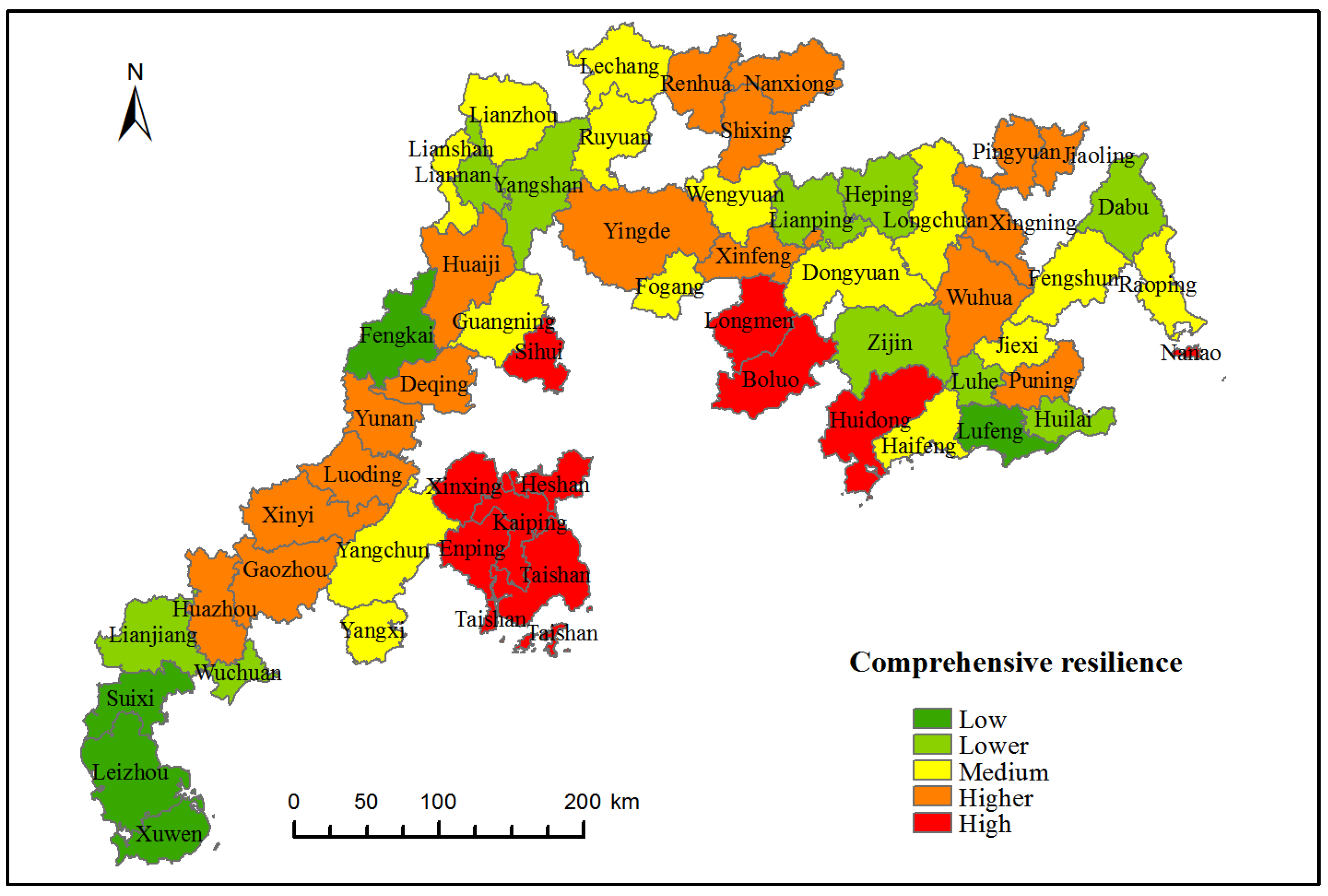
In accordance with the established comprehensive rural resilience evaluation system, the CRITIC method was used to obtain the weights for each index and to calculate the values of the rural resilience index for each county in Guangdong province in 2020 (Table 2). Using the natural breakpoint method, the values were divided into five categories: low (0.3005~0.3638), lower (0.3638~0.4183), medium (0.4183~0.4578), higher (0.4578~0.5044), and high (0.5044~0.6386) values (Figure 3). The overall rural resilience index values in Guangdong province ranged from 0.3005 to 0.6386, with a mean value of 0.4627. The numbers of county units corresponding to the five levels were 5, 10, 15, 17, and 10 for each county, accounting for 8.77%, 17.54%, 26.32%, 29.82%, and 17.54%, respectively, and indicating that most counties in Guangdong province are above the medium level of resilience.

Table 2.
Rural resilience index values in Guangdong province.
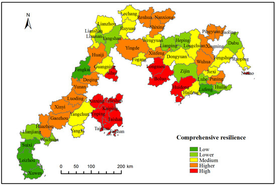
Figure 3.
Comprehensive rural resilience distribution.
In terms of spatial distribution, the areas with high values for the rural comprehensive resilience in Guangdong province were mainly distributed in Jiangmen city and Huizhou city in the PRD region, while the low-value areas were concentrated in Zhanjiang city in western Guangdong, Shanwei city in eastern Guangdong, and Heyuan city in northern Guangdong. The mean values for the overall rural resilience and for each dimension in the PRD region were greater than those in the other regions. The values for rural ecological, social, and governance resilience in western Guangdong were all lower than those in the other areas.
3.2. Spatial Pattern Correlation Analysis of Rural Resilience in Guangdong Province
The correlation and aggregation of the spatial distribution of resilience were characterized based on the global univariate Moran’s I index. The results indicated that both the comprehensive resilience and each dimensional resilience factor showed significant positive spatial correlation characteristics (as shown in Table 3). The Moran’s I indices for both comprehensive and social resilience were greater than 0.4, indicating that the aggregation of their geographical distribution was obvious, and the higher and lower values of resilience were mostly concentrated.

Table 3.
Moran’s I index values for spatial distribution of rural resilience indicators.
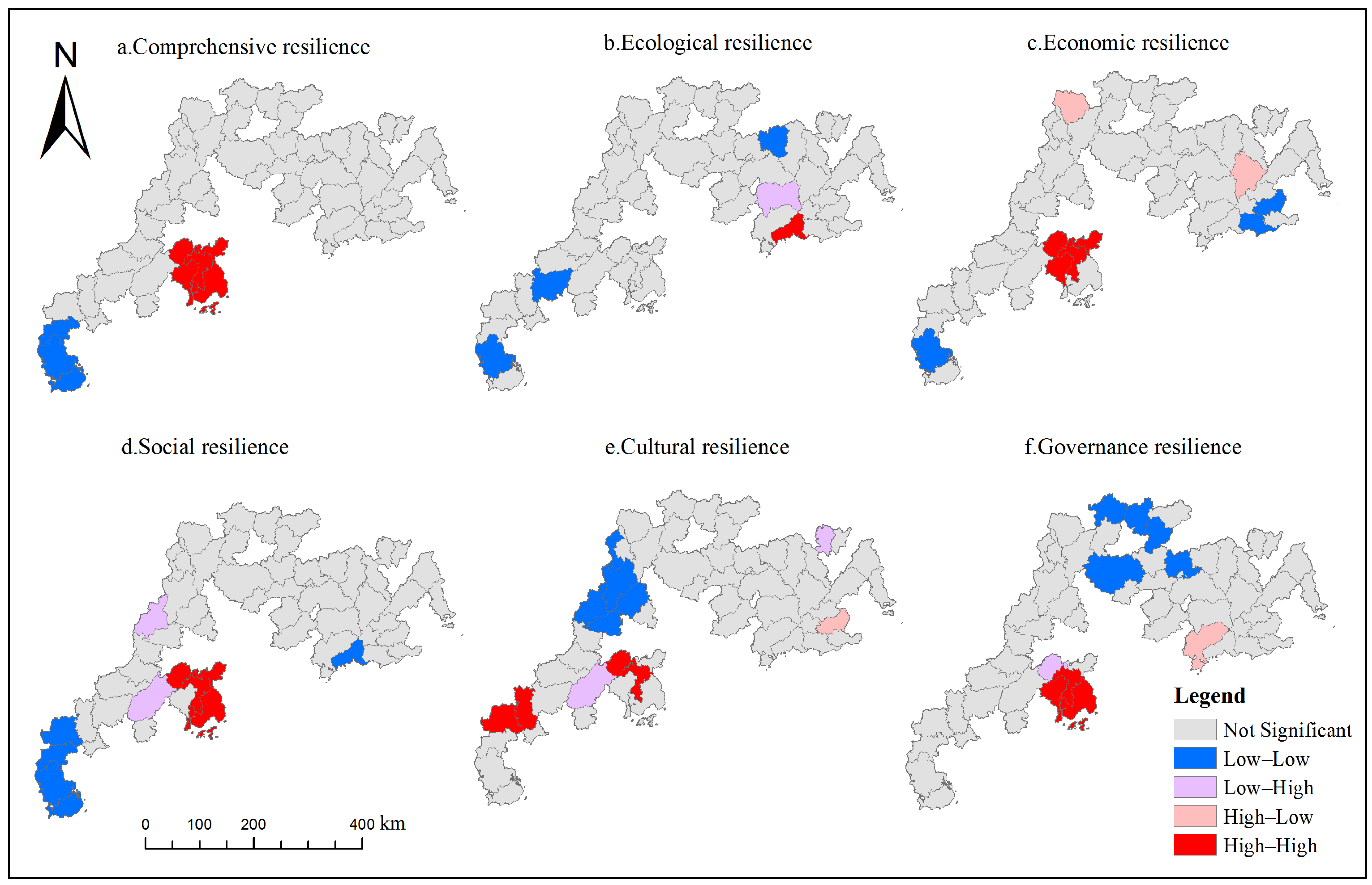
To further reveal the characteristics of the local spatial clustering of rural resilience levels in Guangdong province, a local indicators of spatial autocorrelation (LISA) map of rural resilience was drawn (as shown in Figure 4). The results showed differences in the local clustering characteristics of the comprehensive resilience and of each dimension of resilience in Guangdong province. The high values for the comprehensive resilience were concentrated in Jiangmen in the PRD, and the low values were concentrated in Zhanjiang in western Guangdong, while the other counties showed an insignificant distribution pattern. In the distribution of each sub-dimension of resilience, the high values for economic, social, cultural, and governance resilience were concentrated around Kaiping city in Jiangmen, and the high values for ecological resilience were clustered in Haifeng county in Shanwei.
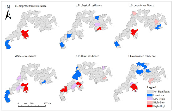
Figure 4.
Rural resilience LISA distribution map.
3.3. Analysis of Factors Influencing Rural Resilience in Guangdong Province
Rural system resilience is influenced by various perturbing factors, such as the ecological environment, social economy, and resource background. Moreover, the government drives various factors, such as capital, resources, and labor, to continuously flow between the rural production spatial system and the external environment through financial allocation and policy enactment, which indirectly affects the resilience level of the rural territorial system. Related studies have found that the natural environment, population size, income level, industrial structure, resource abundance, and financial support are the main factors influencing the rural resilience level [15,16,49]. Drawing on relevant studies and taking into account the actual situation in Guangdong province and the feasibility of data acquisition, the comprehensive rural resilience index was used as the dependent variable. Indicators were selected from three areas—the natural environment (average elevation (X1), average slope (X2)), the social economy (per capita disposable income of rural residents (X3), number of industrial enterprises above a designated size (X4), per capita gross regional product (X5), proportion of secondary and tertiary industries (X6), rural labor-force level (X7), number of tourism resources above grade 3A (X8)), and government input (per capita financial expenditure on agriculture, forestry, and water (X9), per capita financial expenditure on education, science and technology, culture, sports, and media (X10))—to analyze the factors influencing the comprehensive rural resilience (as shown in Table 4).

Table 4.
The factors influencing rural resilience.
3.3.1. Geographical Detection of Influencing Factors
The results showed that eight independent variables passed the significance test, as shown in Table 5. Ranked by the magnitude of the q-value for each influential factor, per capita regional GDP (X5); number of industries above the designated size (X4); average slope (X2); per capita financial expenditure on education, science and technology, culture, sports, and media (X10); and average elevation (X1) were the main factors influencing rural resilience at the county scale, all with explanatory power greater than 40%. Among them, gross regional product per capita (X5) and number of industries above the designated size (X4), which characterize the economic level, were the dominant factors influencing rural resilience with explanatory power greater than 50%, which was significantly higher than that of the other factors.

Table 5.
Statistics for the q-values for influencing factors.
3.3.2. Quantification of Influencing Factor Interactions
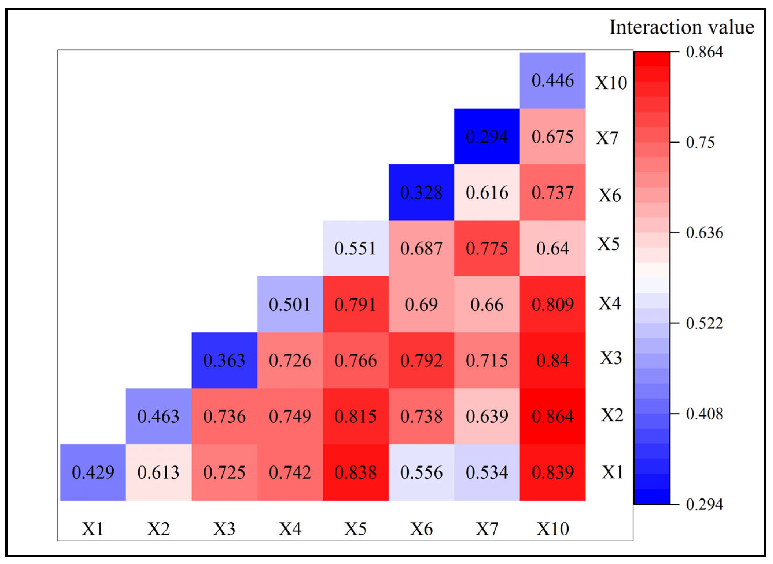
Given that different influencing factors have individual effects on or interactions with rural resilience, interaction detection was further used to investigate whether the interactions between the factors increased or decreased the explanatory power with regard to rural resilience. Eight impact factors (X1, X2, X3, X4, X5, X6, X7, X10) with high q-values that passed the significance tests were selected. The results indicated that the explanatory power of the interactions between the factors was greater than that of the individual factors, showing two-factor enhancement and a nonlinear enhancement type, which demonstrated that the differences in rural resilience levels were affected by the combined effect of multiple influencing factors. Figure 5 shows that the key interaction factors with relatively high levels of influence on rural resilience were X10 ∩ X2, X10 ∩ X1, X10 ∩ X3, X5 ∩ X1, X5 ∩ X2, and X10 ∩ X4, indicating that the interactions of per capita financial expenditure on education, science and technology, culture, sports, and media with topography and economy had the greatest explanatory power with regard to rural resilience.
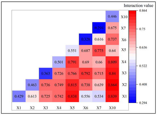
Figure 5.
Interaction statistics for each influencing factor.
3.3.3. Spatial Heterogeneity in the Effects of Influencing Factors
The previous section showed that the Moran’s I index value for the spatial distribution of rural resilience was 0.482, and it passed the significance test of p = 0.001, satisfying the prerequisite requirement of the MGWR model for the spatially heterogeneous distribution of variables. Then, to test the covariance and significance of the factors and avoid the bias of regression model estimation caused by the existence of significant correlations among the influencing factors, the variables were tested for significance and subjected to covariance diagnosis using the stepwise regression model (as shown in Table 6). The results showed that five variables (namely, X4, X5, X6, X7, and X10) passed the significance and covariance tests, so the subsequent MGWR analysis was conducted for these five indicators.

Table 6.
Stepwise regression results for influencing factors.
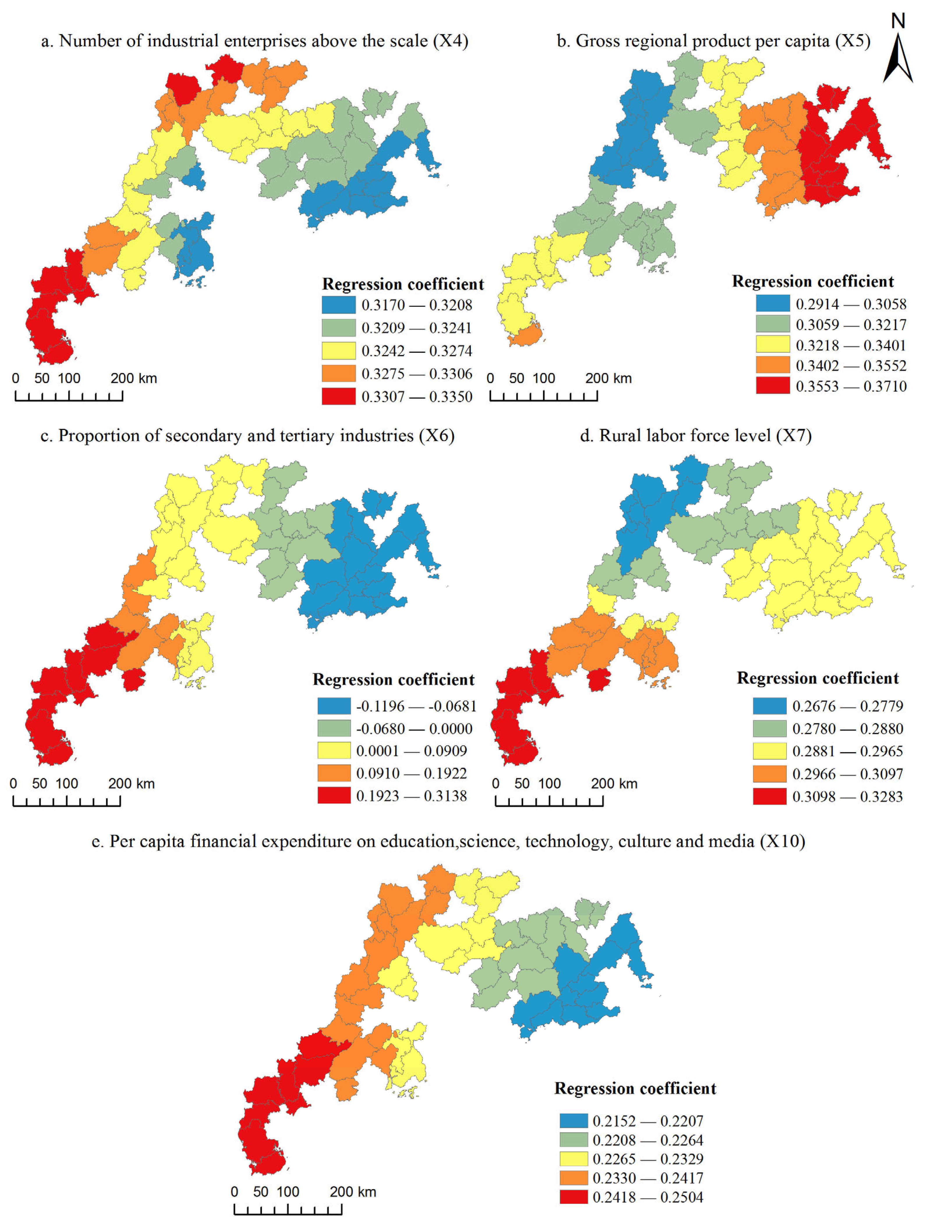
The MGWR model fit better than the OLS and GWR models (as shown in Table 7) because it considers the differences in the spatial scales of action of the influencing factors and uses an adaptive bandwidth. Positive and negative differences were found in the regression coefficients of each influence factor, indicating that each influence factor exerted different forces on rural resilience at different spatial locations (as shown in Table 8). Among them, X4, X5, X7, and X10 all showed positive effects on rural resilience in each county, while X6 showed negative effects in some ranges (as shown in Figure 6).

Table 7.
Comparison of different regression models.

Table 8.
Summary statistics for MGWR model coefficient estimates for each influencing factor.
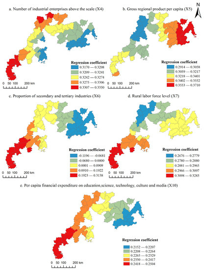
Figure 6.
Distribution of regression coefficients for each influence variable.
- (1)
- The number of industrial enterprises above the designated size (X4). X4 had a positive impact on the resilience of rural areas in each county of Guangdong province. This indicator reflects the level of industrial development in each county, which helps transform and upgrade rural industries, promote the implementation of agricultural modernization, and improve agricultural labor productivity, thus effectively raising the level of farmers’ income. It had a strong driving effect on the resilience of the economic production dimension in each county’s rural areas. The distribution of regression coefficients was lower in the eastern part of Guangdong and the surrounding areas of the PRD and higher in the western and northern parts of Guangdong;
- (2)
- Gross regional product per capita (X5). X5 had a positive effect on rural resilience in each county of Guangdong province. The GDP per capita indicates the level of economic development of a region, which affects the base level of the capital in the villages themselves. Spatially, the magnitude of its influence on rural resilience was high in eastern Guangdong and low in parts of northern Guangdong. Specifically, the influence of the per capita GDP in Lianshan and Liannan counties in the mountainous areas of northern Guangdong was low, mainly because these counties are in remote mountainous areas with weak economic foundations that are relatively lacking in social infrastructure, so the influence of X5 on their rural development was slightly lower than in other counties due to natural geographical conditions;
- (3)
- The proportion of secondary and tertiary industries (X6). X6 reflects the level of economic diversification in each county. In contrast to the influence of other factors, X6 showed a complex direction of influence on rural resilience, with a negative influence in parts of eastern and northern Guangdong and then a gradual increase in the degree of influence to the west;
- (4)
- Rural labor-force level (X7). X7 showed a positive effect on rural resilience in each county of Guangdong province, indicating the importance of the young level in the rural age structure for rural development. Its regression coefficient showed a spatial distribution pattern of being high in western and eastern Guangdong and low in northern Guangdong. The main reason was that the mountainous areas in northern Guangdong are affected by a combination of factors, and an increase in the size of the rural labor force alone has a limited ability to contribute to rural development in these areas;
- (5)
- Per capita financial expenditure on education, science, technology, culture, and media (X10). X10 showed a positive effect on rural resilience in each county of Guangdong province, indicating the supporting effect of rural education level, science, technology, and cultural development level on rural development. Its regression coefficient showed a spatial trend of gradual increasing from the east to the west of Guangdong. The main reason was that the combination of science and technology transformation and agricultural development is better in western Guangdong than in the other parts, and government input in these aspects will significantly promote the development level of agriculture and further enhance the level of rural resilience.
4. Discussion
4.1. Advantages
Rural resilience determines how rural systems respond to external challenges and whether they can maintain a satisfactory level of living [21]. With rapid urbanization and various natural disasters and human-induced disturbances, rural systems are facing the dilemma of decay. Improving the level of resilient development of rural systems so that they can cope with disturbances and impacts and enhancing resilience to achieve rural revitalization have become popular topics in rural geography and urban and rural planning. In the context of the increasingly prominent urban–rural development imbalance in Guangdong province, China, recognizing and assessing the current state of rural resilience can provide useful sustainable development strategies and practical guidance for improving rural resilience.
In this study, we combined rural revitalization objectives with resilience evaluation and constructed a systematic and operational evaluation system based on five dimensions of rural resilience. Using the geographic detector method, we not only focused on the explanatory power of individual factors with regard to rural resilience but also studied the magnitude of multifactor interaction effects on rural resilience. Further, using MGWR, the multiscale spatial heterogeneity of the influencing factors was intensively investigated. The combination of the two models helped to overcome the shortcomings of traditional models in understanding interactions and the limitation related to the uniformity of spatial local bandwidth and improved the accuracy of model simulations. The analysis results revealed the dominant drivers affecting rural resilience, their interactions, and their multiscale spatial heterogeneity, which can help in implementing localized and differentiated optimal governance measures in conjunction with the evaluation of the current situation to realize the sustainable development of rural systems.
4.2. Interpretation and Application
This study found that most of the counties had medium or higher values of comprehensive resilience, and the high-value areas were mainly located in the PRD region. Economic factors were the dominant factors that led to differences in rural resilience across counties in Guangdong, which was consistent with the findings of previous studies [6,16]. Furthermore, the influence of groups of factors was greater than the influence of single factors, especially the interaction of government science, education, and culture investment with natural conditions and economic factors. The economy is the foundation of rural development. Government investment in science, education, and culture can improve the educational levels of residents and the science and technology conversion rate, which, in turn, can enhance the level of rural economic development. Natural conditions are the basis for agricultural development. The interaction of the above three factors affects the development potential of rural areas. In addition, the influences of each dominant influence factor on rural resilience showed significant spatial heterogeneity. Specifically, the proportion of secondary and tertiary industries showed a negative effect in some counties in eastern and northern Guangdong and a positive effect in other regions. The main reason is that the share of secondary and tertiary industries reflects the level of diversification of the economic structure in each county. The impact of economic structure on rural resilience is complex [19], and diversity in the economic structure in counties or townships with a predominantly agricultural economic structure may not be effective in improving the resilience of the rural economy. The degree of integration between agricultural development and secondary and tertiary industries was low in some areas in eastern and northern Guangdong. Rural settlement densities were also low in the northwestern mountainous region [50]. An increase in the proportion of secondary and tertiary industries leads to a decrease in the numbers of employees in the primary industry, which weakens the development of rural agriculture and, therefore, has a negative impact on the level of rural resilience. In contrast, the integration of secondary and tertiary industries with primary industries was high in the areas near western Guangdong and the PRD, and the per capita income of rural residents was also relatively high. Therefore, the greater the economic diversity is, the greater the rural resilience is, resulting in a positive impact on the rural resilience level of each county.
On the basis of the results of the comprehensive evaluation of rural resilience, the following suggestions can be made for the development of each region: (1) In addition to economic development, the governments of counties in the PRD can increase investment in science, education, and culture to improve the level of cultural resilience. In addition to improving physical infrastructure, construction of social infrastructure to increase the resilience of rural communities, such as building social trust, strengthening emotional ties, and focusing on sociocultural structures, should be emphasized [24,51]. (2) East Guangdong should focus on improving economic and cultural resilience, strengthening the integration of secondary and tertiary industries with agriculture, and improving agricultural labor productivity to increase economic output, and the government must also focus on financial investment and infrastructure construction to improve the cultural level of residents and the science and technology conversion rate. (3) The western region of Guangdong should focus on improving ecological and social resilience and strengthening greening construction and livelihood facilities on the basis of adequate economic development. Relevant policies must be developed to attract young people to local employment and reduce rural labor outflow. (4) North Guangdong should focus on improving economic and cultural resilience, combining the advantages of the natural base with economic development, and promoting the transformation and upgrading of rural industries. Meanwhile, the government should also strengthen investment in science, education, and culture to realize a localized rural revitalization strategy. Overall, the centralizing and leading role of the PRD region should be brought into play across various areas, such as natural environmental protection, economic development, and investment in education and science and technology, to narrow the urban–rural development gap and jointly enhance the rural resilience levels of Guangdong counties.
4.3. Limitations
Considering that the level of rural resilience changes over time, further research on the spatiotemporal evolution pattern of rural resilience can be conducted in the future on the basis of rural data from different time points. In addition, the research scale and the types of villages should be refined, and interview surveys on specific rural communities must be conducted to reveal the spatiotemporal evolution processes and laws determining their resilience in each dimension when facing different external challenges.
5. Conclusions
Most of the counties in Guangdong province have medium or higher overall resilience values, with high values mainly in Jiangmen and Huizhou in the PRD region and low values mainly in Zhanjiang in western Guangdong, Shanwei in eastern Guangdong, and Heyuan in northern Guangdong. Both comprehensive and sub-dimensional rural resilience showed significant positive spatial correlation characteristics The geographic detection results for each influence factor indicated the following order: X5 (per capita regional GDP) > X4 (number of industries above the designated size) > X2 (average slope) > X10 (per capita fiscal expenditure on education, science and technology, culture, sports, and media) > X1 (average elevation) > X3 (rural per capita disposable income) > X6 (proportion of secondary and tertiary industries) > X7 (rural labor-force level). Moreover, a significant interaction was found between X10 and X1, X2, and X3, indicating that the interaction between the government’s cultural and technological investment and topographical and economic factors has a significant effect on rural resilience. The MGWR model results showed spatial heterogeneity in the influence of each significant influencing factor on rural resilience. Among them, X4, X5, X7, and X10 showed positive effects on rural resilience, while X6 showed negative effects in some counties in eastern and northern Guangdong.
Author Contributions
Conceptualization, H.W.; methodology, H.W. and Y.X.; software, H.W.; formal analysis, H.W.; data curation, H.W. and Y.X.; writing—original draft preparation, H.W.; writing—review and editing, H.W.; visualization, H.W. and X.W. All authors have read and agreed to the published version of the manuscript.
Funding
This research was funded by the Guangdong General University Young Innovative Talents Project (2022WQNCX028), the Basic and Applied Basic Research Project of Guangzhou Basic Research Program (202102020338), the Guangzhou Social Science Planning Project (2022GZQN18), and the National Natural Science Fund Project of China (52168010).
Data Availability Statement
Not applicable.
Conflicts of Interest
The authors declare no conflict of interest.
References
- Niu, B.; Ge, D.; Sun, J.; Sun, D.; Ma, Y.; Ni, Y.; Lu, Y. Multi-Scales Urban-Rural Integrated Development and Land-Use Transition: The Story of China. Habitat Int. 2023, 132, 102744. [Google Scholar] [CrossRef]
- Li, Y.; Westlund, H.; Liu, Y. Why Some Rural Areas Decline while Some Others Not: An Overview of Rural Evolution in the World. J. Rural Stud. 2019, 68, 135–143. [Google Scholar] [CrossRef]
- Jiang, P.; Chen, D.; Li, M. Farmland Landscape Fragmentation Evolution and Its Driving Mechanism from Rural to Urban: A Case Study of Changzhou City. J. Rural Stud. 2021, 82, 1–18. [Google Scholar] [CrossRef]
- Huang, K.; Cao, S.; Qing, C.; Xu, D.; Liu, S. Does Labour Migration Necessarily Promote Farmers’ Land Transfer-in?—Empirical Evidence from China’s Rural Panel Data. J. Rural Stud. 2023, 97, 534–549. [Google Scholar] [CrossRef]
- Liu, C.; Yi, F. Relative Deprivation and Health Revisited: New Evidence from Middle-Aged and Older Adults in Rural China. China Econ. Rev. 2023, 79, 101948. [Google Scholar] [CrossRef]
- Li, Y.; Song, C.; Huang, H. Rural Resilience in China and Key Restriction Factor Detection. Sustainability 2021, 13, 1080. [Google Scholar] [CrossRef]
- Holling, C.S. Resilience and Stability of Ecological Systems. Annu. Rev. Ecol. Syst. 1973, 4, 1–23. [Google Scholar] [CrossRef]
- Huang, X.; Li, H.; Zhang, X.; Zhang, X. Land Use Policy as an Instrument of Rural Resilience—The Case of Land Withdrawal Mechanism for Rural Homesteads in China. Ecol. Indic. 2018, 87, 47–55. [Google Scholar] [CrossRef]
- Béné, C.; Newsham, A.; Davies, M.; Ulrichs, M.; Godfrey-Wood, R. Resilience, Poverty and Development. J. Int. Dev. 2014, 26, 598–623. [Google Scholar] [CrossRef]
- Peng, C.; Guo, Z.; Peng, Z. Research Progress on the Theory and Practice of Foreign Community Resilience. Urban Plan. Int. 2017, 32, 7. [Google Scholar]
- Ni, X.; Li, X. The Three Approaches for the Assessment on “Resilient City” and Its New Directions in the Future. Urban Plan. Int. 2021, 36, 7–19. [Google Scholar]
- Yang, B.; Feldman, M.W.; Li, S. The Status of Perceived Community Resilience in Transitional Rural Society: An Empirical Study from Central China. J. Rural Stud. 2020, 80, 427–438. [Google Scholar] [CrossRef]
- Wilson, G.A.; Hu, Z.; Rahman, S. Community Resilience in Rural China: The Case of Hu Village, Sichuan Province. J. Rural Stud. 2018, 60, 130–140. [Google Scholar] [CrossRef]
- Sánchez-Zamora, P.; Gallardo-Cobos, R. Diversity, Disparity and Territorial Resilience in the Context of the Economic Crisis: An Analysis of Rural Areas in Southern Spain. Sustainability 2019, 11, 1743. [Google Scholar] [CrossRef]
- Li, H.; Jin, X.; Liu, J.; Feng, D.; Xu, W.; Zhou, Y. Analytical Framework for Integrating Resources, Morphology, and Function of Rural System Resilience—An Empirical Study of 386 Villages. J. Clean. Prod. 2022, 365, 133752. [Google Scholar] [CrossRef]
- Ge, D.; Zheng, Y.; Zhang, S.; Fu, J.; Su, F. Spatio-Temporal Pattern and Influence Mechanism of Rural Human Settlements System Resilience: Case from China. Sustainability 2022, 14, 4533. [Google Scholar] [CrossRef]
- Rathi, A. Is Agrarian Resilience Limited to Agriculture? Investigating the “Farm” and “Non-Farm” Processes of Agriculture Resilience in the Rural. J. Rural Stud. 2022, 93, 155–164. [Google Scholar] [CrossRef]
- Beel, D.E.; Wallace, C.D.; Webster, G.; Nguyen, H.; Tait, E.; Macleod, M.; Mellish, C. Cultural Resilience: The Production of Rural Community Heritage, Digital Archives and the Role of Volunteers. J. Rural Stud. 2017, 54, 459–468. [Google Scholar] [CrossRef]
- Cui, Z.; Li, E.; Li, Y.; Deng, Q.; Shahtahmassebi, A. The Impact of Poverty Alleviation Policies on Rural Economic Resilience in Impoverished Areas: A Case Study of Lankao County, China. J. Rural Stud. 2023, 99, 92–106. [Google Scholar] [CrossRef]
- Liu, L.; Ross, H.; Ariyawardana, A. Building Rural Resilience through Agri-Food Value Chains and Community Interactions: A Vegetable Case Study in Wuhan, China. J. Rural Stud. 2023, 101, 103047. [Google Scholar] [CrossRef]
- Wang, Y.; Zhang, Q.; Li, Q.; Wang, J.; Sannigrahi, S.; Bilsborrow, R.; Bellingrath-Kimura, S.D.; Li, J.; Song, C. Role of Social Networks in Building Household Livelihood Resilience under Payments for Ecosystem Services Programs in a Poor Rural Community in China. J. Rural Stud. 2021, 86, 208–225. [Google Scholar] [CrossRef]
- Kong, X.; Liu, D.; Tian, Y.; Liu, Y. Multi-Objective Spatial Reconstruction of Rural Settlements Considering Intervillage Social Connections. J. Rural Stud. 2021, 84, 254–264. [Google Scholar] [CrossRef]
- Liu, X.; Liu, Z.; Zhong, H.; Jian, Y.; Shi, L. Multi-Dimension Evaluation of Rural Development Degree and Its Uncertainties: A Comparison Analysis Based on Three Different Weighting Assignment Methods. Ecol. Indic. 2021, 130, 108096. [Google Scholar] [CrossRef]
- Wu, X.; Yuan, Z. Understanding the Socio-Cultural Resilience of Rural Areas through the Intergenerational Relationship in Transitional China: Case Studies from Guangdong. J. Rural Stud. 2023, 97, 303–313. [Google Scholar] [CrossRef]
- Davidson, D.J. The Applicability of the Concept of Resilience to Social Systems: Some Sources of Optimism and Nagging Doubts. Soc. Nat. Resour. 2010, 23, 1135–1149. [Google Scholar] [CrossRef]
- Zhang, R.; Yuan, Y.; Li, H.; Hu, X. Improving the Framework for Analyzing Community Resilience to Understand Rural Revitalization Pathways in China. J. Rural Stud. 2022, 94, 287–294. [Google Scholar] [CrossRef]
- Liu, C.; Dou, X.; Li, J.; Cai, L.A. Analyzing Government Role in Rural Tourism Development: An Empirical Investigation from China. J. Rural Stud. 2020, 79, 177–188. [Google Scholar] [CrossRef]
- Li, Y.; Jia, L.; Wu, W.; Yan, J.; Liu, Y. Urbanization for Rural Sustainability—Rethinking China’s Urbanization Strategy. J. Clean. Prod. 2018, 178, 580–586. [Google Scholar] [CrossRef]
- Yang, M.; Jiao, M.; Zhang, J. Spatio-Temporal Analysis and Influencing Factors of Rural Resilience from the Perspective of Sustainable Rural Development. Int. J. Environ. Res. Public Health 2022, 19, 12294. [Google Scholar] [CrossRef]
- Zhang, R.; Li, H.; Yuan, Y. Analyzing Space-Time Evolution of Rural Transition in a Rapidly Urbanizing Region: A Case Study of Suzhou, China. J. Geogr. Sci. 2022, 32, 1343–1356. [Google Scholar] [CrossRef]
- Zhao, X.; Xiang, H.; Zhao, F. Measurement and Spatial Differentiation of Farmers’ Livelihood Resilience under the COVID-19 Epidemic Outbreak in Rural China. Soc. Indic. Res. 2023, 166, 239–267. [Google Scholar] [CrossRef] [PubMed]
- Tan, S.; Zhang, M.; Wang, A.; Ni, Q. Spatio-Temporal Evolution and Driving Factors of Rural Settlements in Low Hilly Region—A Case Study of 17 Cities in Hubei Province, China. Int. J. Environ. Res. Public Health 2021, 18, 2387. [Google Scholar] [CrossRef] [PubMed]
- Su, Q.; Chang, H.-S.; Pai, S.-E. A Comparative Study of the Resilience of Urban and Rural Areas under Climate Change. Int. J. Environ. Res. Public Health 2022, 19, 8911. [Google Scholar] [CrossRef] [PubMed]
- Tang, L.; Long, H.; Ge, D. Spatial differentiation characteristics and mechanism of rural human settlement resilience formation: A case study of Dongting Lake area. ACTA Geogr. Sin. 2023, 78, 1–16. [Google Scholar] [CrossRef]
- Wilson, G. Multifunctional “quality” and Rural Community Resilience. Trans. Inst. Br. Geogr. 2010, 35, 364–381. [Google Scholar] [CrossRef]
- Kelly, C.; Ferrara, A.; Wilson, G.A.; Ripullone, F.; Nole, A.; Harmer, N.; Salvati, L. Community Resilience and Land Degradation in Forest and Shrubland Socio-Ecological Systems: Evidence from Gorgoglione, Basilicata, Italy. Land Use Policy 2015, 46, 11–20. [Google Scholar] [CrossRef]
- Fan, J.; Mo, Y.; Cai, Y.; Zhao, Y.; Su, D. Evaluation of Community Resilience in Rural China-Taking Licheng Subdistrict, Guangzhou as an Example. Int. J. Environ. Res. Public Health 2021, 18, 5827. [Google Scholar] [CrossRef]
- Jiang, L.; Li, Z. Urbanization and the Change of Fertilizer Use Intensity for Agricultural Production in Henan Province. Sustainability 2016, 8, 186. [Google Scholar] [CrossRef]
- Astier, M.; Orozco-Ramirez, Q.; Walker, R.; Galvan-Miyoshi, Y.; Gonzalez-Esquivel, C.; Simmons, C.S. Post-NAFTA Changes in Peasant Land Use-The Case of the Patzcuaro Lake Watershed Region in the Central-West Mexico. Land 2020, 9, 75. [Google Scholar] [CrossRef]
- Clay, N.; Zimmerer, K.S. Who Is Resilient in Africa’s Green Revolution? Sustainable Intensification and Climate Smart Agriculture in Rwanda. Land Use Policy 2020, 97, 104558. [Google Scholar] [CrossRef]
- Su, F.; Luo, J.; Liu, H.; Tong, L.; Li, Y. Assessment and Promotion Strategy of Rural Resilience in Yangtze River Delta Region, China. Sustainability 2022, 14, 5382. [Google Scholar] [CrossRef]
- Chen, H.; Chen, C.; Li, Y.; Qin, L.; Qin, M. How Internet Usage Contributes to Livelihood Resilience of Migrant Peasant Workers? Evidence from China. J. Rural Stud. 2022, 96, 112–120. [Google Scholar] [CrossRef]
- Zou, X.; Xie, M.; Xiao, Z.; Wu, T.; Yin, Y. Evaluation of rural development and diagnosis of obstacle factors based on entropy weight topsis method. Chin. J. Agric. Resour. Reg. Plan. 2021, 42, 197–206. [Google Scholar] [CrossRef]
- Zhang, F.; Wang, P.; Mu, P.; Wang, M.; Han, L.; Sun, J. A Comprehensive Evaluation Method for the Service Status of Groins in Waterways Based on an AHP-Improved CRITIC Combination Weighting Optimization Model. Sustainability 2022, 14, 709. [Google Scholar] [CrossRef]
- Wang, J.-F.; Li, X.-H.; Christakos, G.; Liao, Y.-L.; Zhang, T.; Gu, X.; Zheng, X.-Y. Geographical Detectors-Based Health Risk Assessment and Its Application in the Neural Tube Defects Study of the Heshun Region, China. Int. J. Geogr. Inf. Sci. 2010, 24, 107–127. [Google Scholar] [CrossRef]
- Song, Y.; Wang, J.; Ge, Y.; Xu, C. An Optimal Parameters-Based Geographical Detector Model Enhances Geographic Characteristics of Explanatory Variables for Spatial Heterogeneity Analysis: Cases with Different Types of Spatial Data. GISci. Remote Sens. 2020, 57, 593–610. [Google Scholar] [CrossRef]
- Oshan, T.M.; Li, Z.; Kang, W.; Wolf, L.J.; Fotheringham, A.S. MGWR: A Python Implementation of Multiscale Geographically Weighted Regression for Investigating Process Spatial Heterogeneity and Scale. ISPRS Int. J. Geo-Inf. 2019, 8, 269. [Google Scholar] [CrossRef]
- Fotheringham, A.S.; Yang, W.; Kang, W. Multiscale Geographically Weighted Regression (MGWR). Ann. Am. Assoc. Geogr. 2017, 107, 1247–1265. [Google Scholar] [CrossRef]
- Zi, M.; Zhou, Y.; Luo, J.; Zhang, C.; Gao, Z. Measurement and influencing factors of rural regional system resilience in mountainous areas: A case study of Luotian County in the Dabie Mountains. Prog. Geogr. 2022, 41, 1819–1832. [Google Scholar] [CrossRef]
- Gong, J.; Jian, Y.; Chen, W.; Liu, Y.; Hu, Y. Transitions in Rural Settlements and Implications for Rural Revitalization in Guangdong Province. J. Rural Stud. 2022, 93, 359–366. [Google Scholar] [CrossRef]
- Zhang, X.; Luo, Y.; Liu, Y.; Han, Z.; Wang, F. Resilience in Urban, Rural, and Transitional Communities: An Empirical Study in Guangdong, China. Int. J. Disaster Risk Reduct. 2023, 84, 103396. [Google Scholar] [CrossRef]
Disclaimer/Publisher’s Note: The statements, opinions and data contained in all publications are solely those of the individual author(s) and contributor(s) and not of MDPI and/or the editor(s). MDPI and/or the editor(s) disclaim responsibility for any injury to people or property resulting from any ideas, methods, instructions or products referred to in the content. |
© 2023 by the authors. Licensee MDPI, Basel, Switzerland. This article is an open access article distributed under the terms and conditions of the Creative Commons Attribution (CC BY) license (https://creativecommons.org/licenses/by/4.0/).

