Article

Active Utilization of Linear Cultural Heritage Based on Regional Ecological Security Pattern along the Straight Road (Zhidao) of the Qin Dynasty in Shaanxi Province, China

1
Northwest Land and Resource Research Center, Shaanxi Normal University, Xi’an 710119, China
2
Natural Resources and National Land Use Research Institute, Shaanxi Normal University, Xi’an 710119, China
*
Author to whom correspondence should be addressed.
Land 2023, 12(7), 1361; https://doi.org/10.3390/land12071361
Submission received: 23 May 2023 / Revised: 4 July 2023 / Accepted: 6 July 2023 / Published: 7 July 2023
(This article belongs to the Section Land Planning and Landscape Architecture)

Abstract

:
Linear cultural heritage—a heritage system spanning time and space—is a large-scale cultural settlement that accommodates various heritage types. Here, we comprehensively explored the Straight Road (Zhidao) of the Qin Dynasty in Shaanxi Province, China, as a gene of traditional cultural connotations and geographical features, and provided holistic conservation strategies and effective utilization paths. From an ecological security pattern perspective, 4399.89 km2 of ecological sources and 19 ecological nodes were identified based on the importance of four ecosystem services—carbon sequestration and oxygen release, water conservation, habitat maintenance, and soil retention. Then, 45 ecological corridors with a total length of 2938.49 km were determined using the minimum cumulative resistance model. The intersections of ecological corridors were distinguished and the key areas of cultural landscape construction were extracted by taking into account the spatial distribution of existing relics as well as the spatial network relationship of prohibited-development areas and existing gray corridors (roads), blue corridors (rivers), and green ecological corridors (shade zones, green belts, recreational greenways). A plan was proposed to construct 98.45 km2 of new parks (country parks: 28.38 km2, forest parks: 70.07 km2) and 101.26 km of new landscape corridors (urban type: 32.08 km, countryside type: 26.49 km, ecological type: 42.69 km). Multilevel landscape complexes should be built to form a functional and networked ecological–cultural spatial structure system. Findings of this study could provide ecological ideas for promoting the reservation and active utilization of linear cultural-heritage corridors on a regional scale.

1. Introduction

Linear cultural heritage, derived and expanded from culture routes, is a group of tangible and intangible cultural heritage sites for particular purposes that is formed in linear or belt-like regions with a specific collection of cultural resources [1]. Linear cultural heritage enables a serial connection between originally unrelated villages and small towns, resulting in a chain-like state of cultural relics [2]. It not only provides a true representation of spatial shifts in historical human activities and interactions between tangible and intangible cultures, but also conveys humanistic significance and cultural connotation as a major carrier of cultural heritage [3]. Since the 1990s, the development of cross-regional linear-cultural-heritage tourism has received increasing attention from the world for facilitating heritage cultural inheritance and communication, as well as regional economic development [4,5]. Especially in the 21st century, linear cultural heritage is rapidly developing and its modern functions are manifested in many fields, including tourism development, ecological conservation, economic balance, national identity, regional stability maintenance, and international cooperation [6].
In recent decades, there has been a growing awareness of concepts and connotations such as linear cultural heritage, culture routes, and heritage corridors [7,8]. With respect to cultural-heritage conservation, previous studies have focused on cross-regional linear heritage that mirrors the integrity and continuity of natural and human landscapes, and embodies the social, economic, and cultural development trends of human beings in historical periods [9,10,11]. The emphasis of cultural heritage conservation is shifting (i) from heritage with single elements to both ‘mixed heritage’ and ‘cultural landscape’ resulting from the interaction between cultural and natural elements; (ii) from ‘spotty heritage’ and ‘areal heritage’ to both ‘large-scale cultural heritage’ and ‘linear cultural heritage’; (iii) from ‘static heritage’ to both ‘dynamic heritage’ and ‘living heritage’ [12]. Linear cultural heritage has mainly been investigated from the following three perspectives. First, heritage studies demonstrate the value of heritage and propose conservation strategies [13,14,15]. Second, tourism studies involve tourism product development, brand image shaping, regional-tourism cooperation, tourism-evaluation indicators, and tourist behaviors [16,17,18]. Third, spatial studies explore the spatial patterns and construction of heritage, in addition to the application of spatial information technology [19,20,21]. The emerging concept of ancient-road tourism arises from the coupling of heritage, tourism, and space over a long span of time, which is a new hot topic of research in geography and tourism [22]. With the simple tourism development of linear cultural heritage, it is easy to fall into the trap of homogenization, with insufficient attention to natural background particularity and regional carrying capacity [23,24]. The ecologically and environmentally friendly development of ancient-road tourism necessitates an organic connection between the natural ecological environment alongside linear cultural-heritage corridors and their intrinsic humanistic characteristics [25].
In 221 B.C., the first emperor (Shihuang) of the Qin Dynasty unified China. Because the Huns (Xiongnu) had not been eliminated yet, General Meng Tian was ordered to build a straight road connecting the Linguang Palace in Chunhua County, Shaanxi Province to Jiuyuan County in Baoto, Inner Mongolia. The ‘Straight Road (Zhidao) of the Qin Dynasty’ played multiple roles in national defense, cultural communication, economic exchange, and ethnic integration. It interpreted historical patterns in the gradual unification of the Chinese nation and maintained a pluralistic and integrated system of China. Additionally, the Qin Straight Road—a major part of the ‘Grassland Silk Road’—promoted the exchange of East–West civilizations and the cultural progress of mankind [26,27]. In China, the ecological conservation and high-quality development of the Yellow River Basin was proposed a major national strategy in 2019, which inevitably rendered it necessary to implement cultural construction [28]. In the 2021 Outline of the Plan for Ecological Conservation and High-quality Development of the Yellow River Basin, it was also explicitly stated ‘to build a diverse and harmonious cultural demonstration zone of the Yellow River Basin’. In this context, the proper conservation and utilization of historical cultural heritage is undoubtedly an essential pathway to strengthen cultural confidence, demonstrate cultural power, and accelerate the high-quality development of the Yellow River Basin [29]. The Qin Straight Road starts from Shaanxi Province in the Yellow River Basin, and the heritage value of this unique cultural exchange channel is self-evident.
However, there are still certain issues among the practical heritage conservation and utilization of the Qin Straight Road that deserve to be further explored. First, the cultural-heritage nature of the Qin Straight Road has not been fully recognized and its status of conservation and development need to be identified, while a unified heritage management system is still lacking. Second, limited attention is paid to urban and rural development along the Qin Straight Road, owing to the limited awareness of the heritage value, which may lead to constructive or developmental damage at any time [30,31]. Third, the combination of the natural and cultural characteristics of linear cultural heritage could consequently facilitate its scientific conservation, tourism development, and active utilization. However, there has been a dearth of research deciphering the evolutionary patterns, mechanisms, and processes of linear cultural heritage exemplified by the Qin Straight Road based on the perspective of regional ecological security. These issues call for research from a higher perspective to re-understand the cultural heritage nature of the Qin Straight Road, identify its comprehensive natural and cultural value, and develop holistic conservation strategies and effective utilization paths.
The aims of this study were to (1) characterize the culture and ecological resources along the Qin Straight Road in Shaanxi Province, (2) establish the ecological security pattern and identify the spatial interaction of various landscape corridors in the study area, and (3) design construction projects and the corresponding infrastructure and recreational service facilities with regional features. In this study, we thoroughly explored the Qin Straight Road in Shaanxi Province as a gene of traditional cultural connotations and geographical features based on the identification of ecological sources and ecological nodes. The regional ecological security pattern was constructed to determine ecological corridors with connectivity on a macroscopic scale. And the spatial distribution of existing relics was taken into account to select the locations for key construction projects in order to actively utilize the Qin Straight Road. The distribution characteristics and planning guidelines of key projects were summarized in different classes, which allowed the classified design of ecological and cultural corridors as well as the forest and country parks. Results of this study could provide strong support for the comprehensive functional development of ecological and cultural corridors in such linear cultural heritage.

2. Materials and Methods

2.1. Study Area

The region along the Qin Straight Road in Shaanxi Province is located on the main route of the Silk Road Economic Belt and covered by the national strategy of ecological conservation and high-quality development of the Yellow River Basin (Figure 1). It mainly encompasses nine counties and districts in northwestern Shaanxi (108°19′–110°01′ E and 34°43′–38°14′ N)—Chunhua County and Xunyi County in Xianyang City; Huangling County, Fu County, Ganquan County, Zhidan County, and Ansai District in Yan’an City; Jingbian County and Hengshan District in Yulin City. This region is long from north to south and narrow from east to west, bordering the Inner Mongolia Autonomous Region in the north and Gansu Province in the west. It covers a total area of ~27,662 km2, accounting for 13.44% of the total area of Shaanxi Province. The total population had reached 1.94 million people by the end of 2021. Located on the Loess Plateau, this region has an elevation of 695–1792 m. Its topographic pattern is low at the northern and southern edges and high in the central part, with the western part considerably higher than the eastern part. All rivers belong to the Yellow River system and flow through the deep loess region.

2.2. Data Sources

The data used in this study consisted of natural environmental data and basic geographic-information data. Meteorological observation data were downloaded from the Resource and Environment Science and Data Center (https://data.cma.cn/, accessed on 20 October 2022). We interpolated the data from meteorological stations in Shaanxi Province and the surrounding areas to obtain the spatial distribution of precipitation. Land use/cover change, evapotranspiration, and net primary productivity data in 2021 were derived from the MODIS products MCD12Q1, MOD16A3GF, and MOD17A3HGF, respectively, with a spatial resolution of 500 m. Normalized-difference vegetation-index data were derived from the MODIS product MOD13A3 with a 1 km resolution. Elevation data were obtained from the Data Center for Resource and Environment Sciences, Chinese Academy of Sciences (https://www.resdc.cn/Default.aspx, accessed on 15 September 2022). Soil erosion data were retrieved from the Ecosystem Assessment and Ecological Security Pattern Database of China (https://www.ecosystem.csdb.cn/, accessed on 23 October 2022). River and traffic data were downloaded from the Resource and Environment Data Cloud Platform, Chinese Academy of Sciences (http://www.resdc.cn/, accessed on 21 September 2022) and the Open Street Map (https://www.openstreetmap.org/, accessed on 27 October 2022), respectively.

2.3. Ecological Source Identification

Ecological sources are defined as existing native ecosystems (e.g., habitats of native species), which are the sources of ecological flows [32]. Ecological sources can maintain the integrity of ecosystem structure, function, and processes while facilitating the sustainable provision of ecosystem services [33]. Therefore, we extracted the areas having high ecosystem service importance as ecological sources. First of all, attention should be paid to carbon sequestration and oxygen release along the Qin Straight Road, given the vital function of the ecological landscape in regulating the local microclimate and supplying biological products. Additionally, water conservation plays a key role in maintaining regional ecological security, because dense river networks support ecological landscape development. Biodiversity should also be taken into account in ecological source identification because of abundant wildlife resources in the study area. Furthermore, soil retention is a key ecosystem service in this region, as an uneven rainfall distribution and complex topography lead to soil erosion. Based on the ecological characteristics along the Qin Straight Road, we selected four ecosystem services—carbon sequestration and oxygen release, water conservation, habitat maintenance, and soil retention—to identify ecological sources in the study area [34].
The carbon sequestration and oxygen-release capacity was evaluated based on net primary productivity. The water-balance equation was used to calculate water conservation (unit: mm) as the difference between mean precipitation and evapotranspiration. With respect to habitat maintenance, the Habitat Quality module of the InVEST model (https://naturalcapitalproject.stanford.edu/software/invest, accessed on 11 September 2022) was employed to calculate habitat quality (Equation (1)), which depends on human land uses and their accessibility [35].
Q x j = H j × 1 D x j z D x j z + k z
where Q x j is the habitat quality score of landscape patch group x under land use type j, H j is habitat suitability under land-use type j (with construction land, farmland, railways, and highways as threat sources in this study), D x j is the threat level of grid x under land-use type j, z is 2.5 by default, and k is the half-saturation constant. The landscape habitat-quality score ranges between 0 and 1. Non-habitat landscape areas are scored as 0, and a larger score means a superior habitat quality, which can better support species coexistence and biodiversity maintenance.
Soil retention is not only closely related to soil type, but is also affected by topography and external disturbance intensity [36]. Soil retention capacity was calculated based on the Revised Universal Soil Loss Equation (RUSLE; Equation (2)), and the actual soil erosion was subtracted from the potential soil erosion to obtain the soil retention amount [37,38].
A = R × K × L S × 1 C × P
where A is soil retention amount (t∙hm−2∙yr−1), R is rainfall erosivity factor (MJ·mm·hm−2·h−1·yr−1), K is the soil erodibility factor (t·hm2·h·MJ−1·mm−1·hm−2), LS is the slope and length factor (dimensionless), C is the vegetation cover and management factor (dimensionless), and P is the soil erosion-control practice factor (dimensionless).
When assessing the importance of ecosystem services, we first normalized the data to eliminate the influence of the dimension. Then, the spatial analysis tool of ArcMap version 10.5 (ESRI, Redlands, CA, USA) was used to assign weights to ecosystem services based on the status quo of the regional ecological environment: 0.2 for carbon sequestration and oxygen release, 0.3 for water conservation, 0.2 for habitat maintenance, and 0.3 for soil retention. The importance layer of ecosystem services in the study area was obtained by a weighted overlay method. Furthermore, the natural breakpoint method was used to classify the individual service importance into four levels—extremely important, important, moderately important, and unimportant. Each importance level was assigned a value from 1 to 4, with a greater value indicating a higher service importance. And the extremely important landscape patches were selected as the sources of ecological security pattern.

2.4. Ecological Resistance Surface Construction

The minimum cumulative resistance (MCR) model proposed by Knappen was originally used to analyze species dispersal [39]. It estimates the cost of various ‘sources’ to cross the landscape with different resistance, or the work carried out to overcome this resistance. We constructed the ecological source expansion resistance surface [40,41] using the MCR model (Equation (3)) modified by Yu et al. (2009) [42]. This modified model takes into account multiple factors (i.e., source, distance, landscape interface) to calculate the cost for species to migrate from the source to a destination. It reveals the potential possibilities and trends for species migration, and simulates the process of organisms crossing different landscape interfaces.
M C R = f m i n j = n i = m D i j × R i
where D i j is the spatial distance of a given species from source j to landscape unit i, R i is the resistance coefficient of landscape unit i to the migration of that species, and f indicates a positive correlation between MCR and D i j or R i .
Landscape cover type and topographic slope are the major sources of resistance to the outward expansion of ecological sources. There exists a close association between ecological environment sensitivity and ecological source expansion. Therefore, we selected the topographic-position index [43], land-use type [44], and soil erosion intensity [45] as the resistance factors based on the main characteristics of the ecological environment in the study area. The relative resistance values were set separately and the factor weights were determined by the analytic hierarchy process [46]. The cumulative resistance to outward ecological source expansion was calculated based on a weighted summation. The larger the relative resistance value of various factors, the higher the resistance to ecological source expansion, and vice versa [47].

2.5. Ecological Network Establishment

An ecological network consists of various ecological nodes and intersecting ecological corridors [48,49]. Within the network, a range of ecosystems are connected through communication of living organisms and embedded landscape matrices, forming a spatially coherent system [50]. Ecological nodes are landscape components distributed in an ecological space, which link adjacent ecological sources and contribute to ecological flows [51]. Ecological corridors are strip-like areas that play a prominent role in connecting material, energy, and information flows; in particular, they provide major passages for species migration [52]. The ecological network effectively connects fragmented landscape patches through ecological corridors, which forms a continuous spatial structure and thus lowers the risk of landscape fragmentation. It conveys benefits to regional biodiversity conservation and ecological quality improvement while maintaining the integrity of ecological processes under the impact of human activities [53]. We extracted the center point of major source patches as the ecological node. After that, each node was regarded as the center, with the remainder n − 1 (n = the total number of nodes) as a target-node cluster. Based on the MCR model, n-layer-based minimum cost paths were obtained as ecological corridors among source patches [54,55]. Finally, the spatial distribution of ecological corridors and nodes along the Qin Straight Road was obtained.

2.6. Technology Flow and Required Indicators of Natural and Cultural Assets

In this study, research on the protection and utilization of linear cultural heritage could be carried out according to the following steps: (1) build a database of regional natural and cultural assets, (2) spatialize the location and direction of the heritages, (3) identify the ecological sources, ecological nodes and ecological corridors in the research area, (4) analyze the spatial interactions between cultural heritage and the ecological security pattern, and (5) propose solutions and construction plans in different categories. For example, put forward solutions for areas with spatial conflicts between cultural heritage corridors and existing green, blue and gray corridors; propose protection plans for cultural heritage in densely constructed urban areas; and flexible construction plans should be proposed for the cultural heritage sites surround by superior ecological resources (e.g., theme parks, ecological and cultural leisure corridors, museums and science popularization bases). It should be pointed out that this method has no limitations on the research of different spatial scales, but in small-scale areas, attention should be paid to ensuring that the dataset of natural environment has a high spatial resolution.
Table 1 shows the indicators of natural and cultural assets along the Qin Straight Road selected in the database. Natural assets are the landscape elements that provide healthy surroundings, recreational opportunities, clean water, and food for people and wildlife [56]. In this study, the natural assets of forest, grassland, cropland, waterway, wetland, etc., were represented by the regional land-use dataset. Meanwhile, the typical ecosystem services, ecological sources, nodes, and corridors were also the important components of natural assets along the Qin Straight Road. Cultural assets are the landscape elements that people value, such as historic sites, archaeological sites, heritage sites, or cultural landscapes [57]. The cultural assets in this study included the key sites of cultural heritage, routes and directions of the Qin Straight Road, the socio-economic development of the counties where the heritage sites are located, and the construction of culture-related infrastructures. The natural assets along the Qin Straight Road supported cultural assets by providing scenic backdrops and buffers to historic sites, providing settings in which to enjoy them [58]. And as natural assets are protected or curated to appeal to heritage tourism, additional economic benefits could be generated to further support the conservation and development of the Qin Straight Road.

3. Results

3.1. Spatial Patterns of Ecological Sources

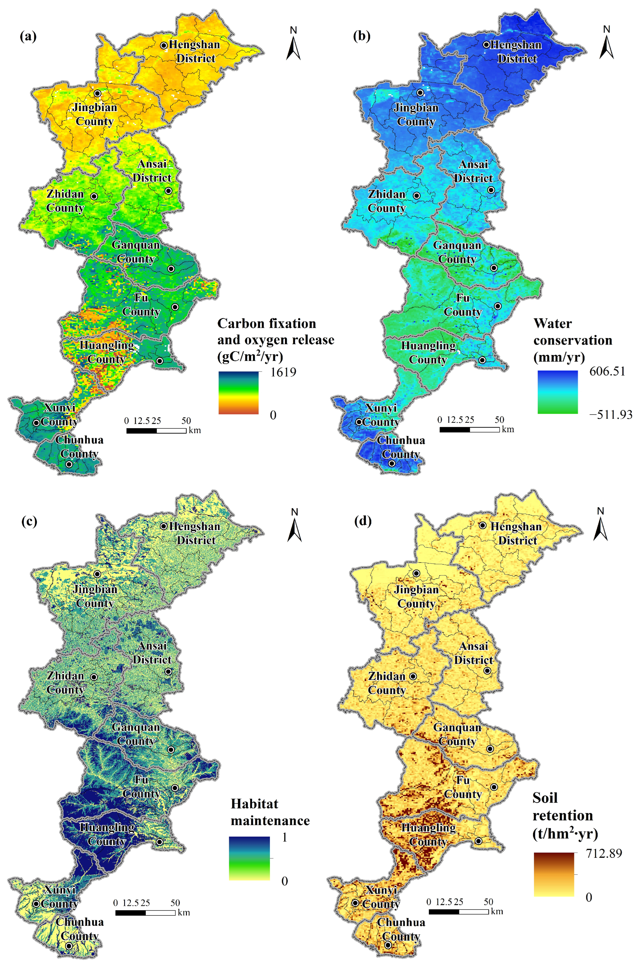
The carbon sequestration and oxygen release capacity in terms of net primary productivity varied from 0 to 1619 gC m−2yr−1, and high values occurred in the central and southern parts of the study area, with relatively low values in the northern part (Figure 2a). This function was most prominent in Ganquan County, Fu County, and Chunhua County, and was weakest in Hengshan District and Jingbian County. There was considerable spatial variation in the carbon sequestration and oxygen release capacity in Fu County and Huangling County, where the lowest values were observed. Water conservation exhibited an overall spatial differentiation pattern, which was high at the northern and southern edges and low in the central part of the study area. The highest water-conservation capacity was observed in Hengshan District, Jingbian County, and Chunhua County (Figure 2b). Under the combined effect of regional precipitation and surface evapotranspiration, the mean water conservation ranged from –511.93 to 606.51 (mm yr−1), and the ecological landscapes in central counties had a relatively low capacity for water conservation. Based on habitat quality scores, the habitat maintenance function was strongest in Ganquan County, Fu County, and Huangling County (Figure 2c). The soil retention function was generally prominent in the southern part of the study area and weak in the northern part (Figure 2d).
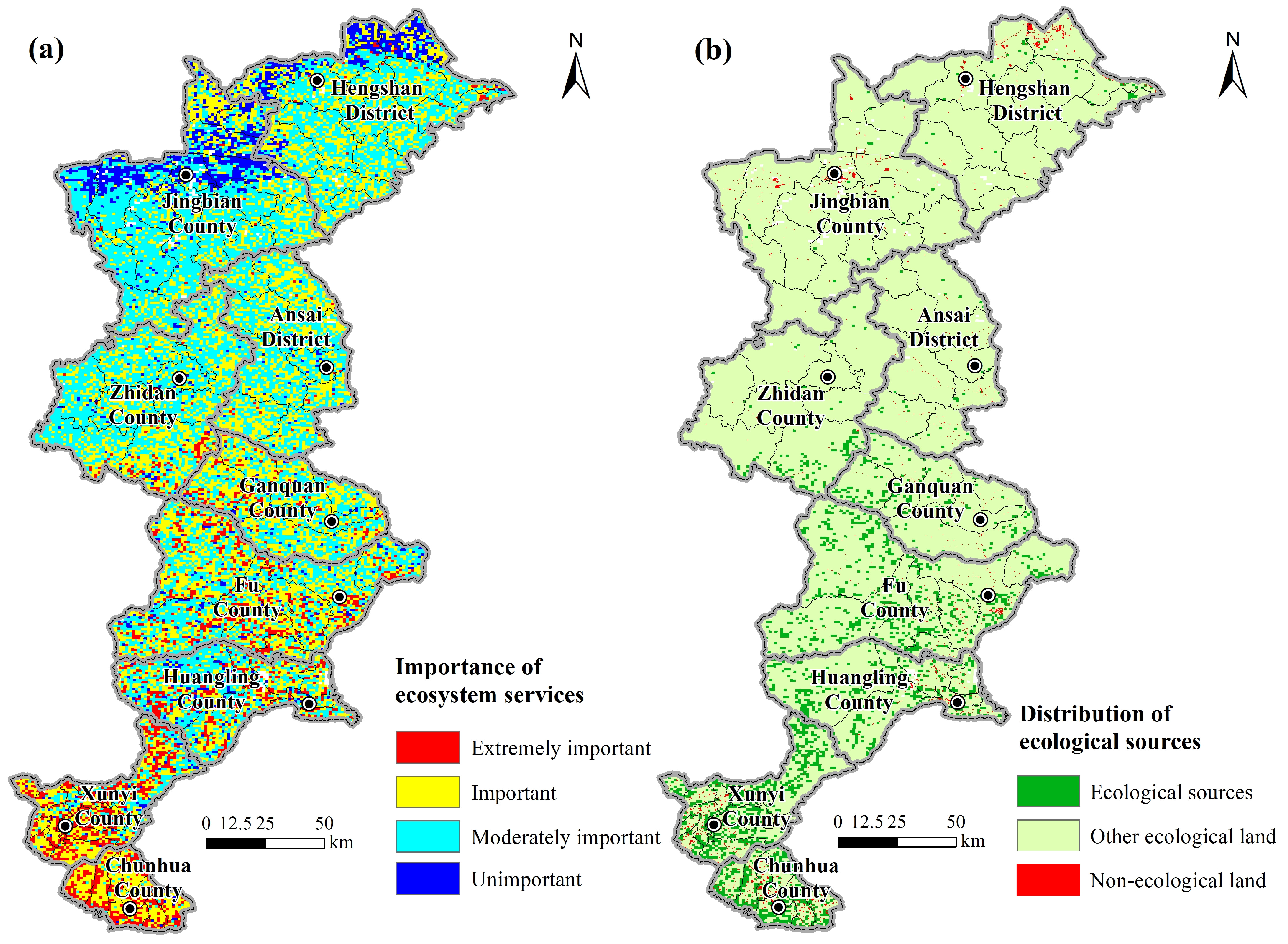
The importance of ecosystem services was overall higher in the southern part of the study area than in the northern part (Figure 3a). The patches scoring unimportant in the service importance level were almost all concentrated in the Hengshan District and Jingbian County, and distributed in a band from northeast to southwest. The ecological sources made up 17.82% of the total study area, with a concentrated and contiguous distribution in Xunyi County and Chunhua County (Figure 3b). The distribution of ecological sources in Huangling County, Fu County, Ganquan County, and Zhidan County was relatively scattered. However, ecological sources were obviously lacking in Hengshan District, Jingbian County, and Ansai District.

3.2. Distribution of Ecological Resistance Surface

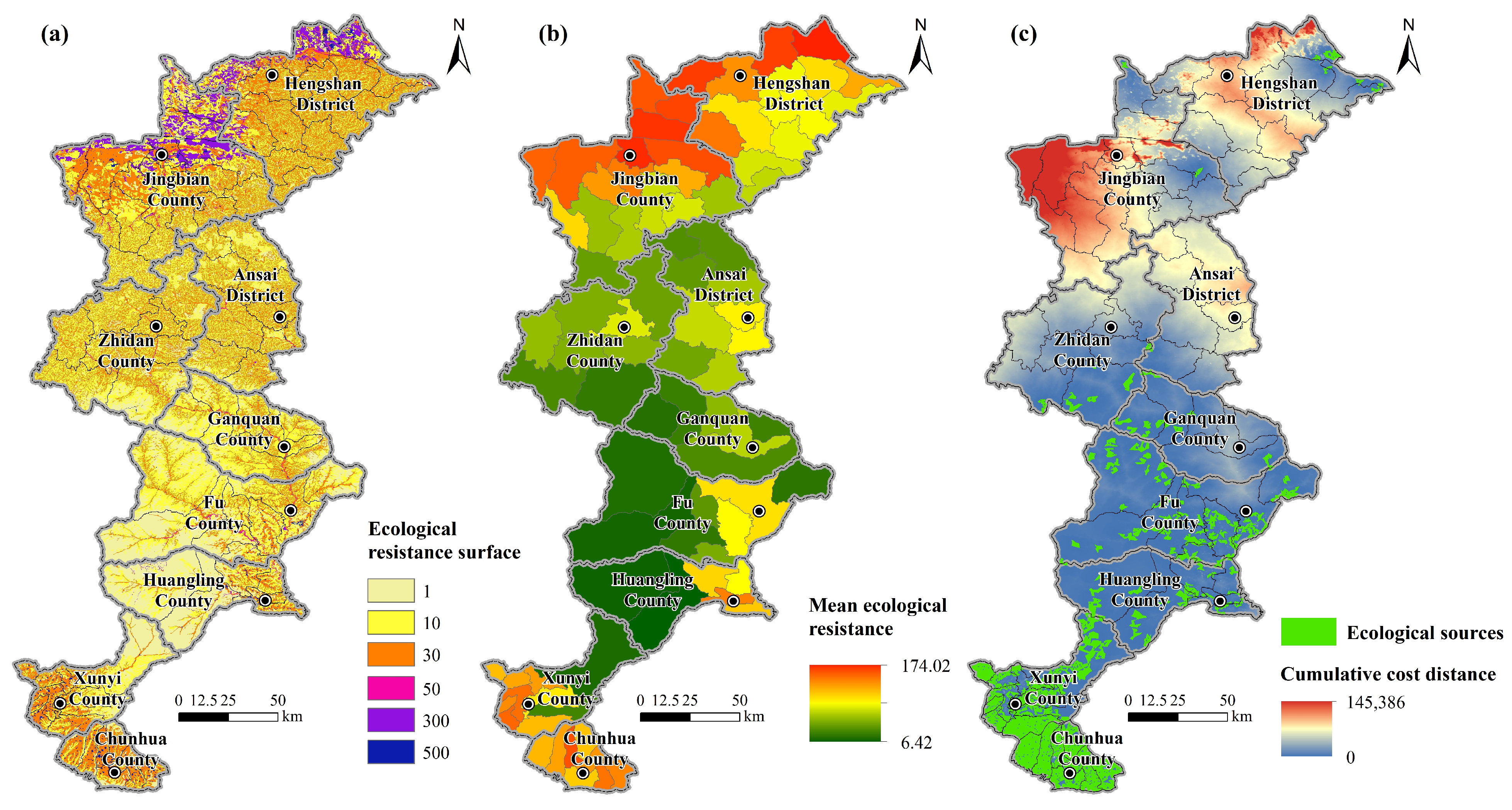
In addition to having a high-importance level of ecosystem services, ecological sources should be concentrated and contiguous over a larger area. Therefore, we selected >5 km2 source patches to calculate the cumulative cost distance of material and information flows under resistance among ecological sources. The cost value of each grid represents the sum of the costs incurred by species to reach a destination through the ecological resistance surface (Figure 4). High ecological resistance values were found in the northern and southern parts of the study area, with low values in the central part. The mean ecological resistance at the county level was ordered from high to low as follows: Jingbian County (58.16), Hengshan District (53.84), Chunhua County (43.52), Xunyi County (23.29), Ansai District (18.73), Zhidan County (16.34), Ganquan County (15.06), Huangling County (13.15), and Fu County (13.11). Further analysis of the mean ecological resistance at the town level revealed that Baijie Town (Hengshan District) ranked first (174.02), whereas Diantou Town (Huangling County) ranked last (6.42). The spatial differentiation of town-level ecological resistance indicated a prominent polarization effect of ecological function flow and transmission resistance at the southern and northern edges of the study area. In contrast, landscape heterogeneity generally had a less prominent effect on the connectivity of species migration in the central part of the study area.

3.3. Characteristics of Ecological Security Pattern

3.3.1. Ecological Network and Ecological Security Pattern

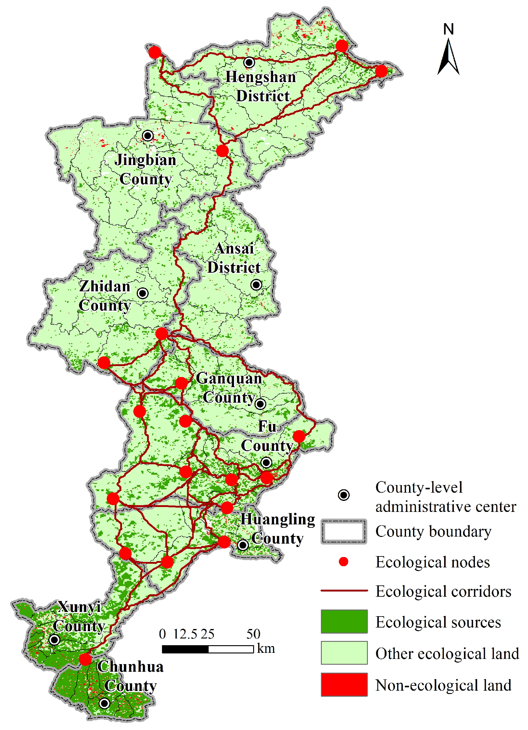
In the study area, the ecological corridors extended from south to north along the inner edge of the study area and formed a high-connectivity network in the central area with the ecological nodes. Specifically, a total of 19 ecological nodes were extracted based on the major ecological sources. There were seven nodes in Fu County, three nodes in Huangling County, two nodes in Hengshan District, two nodes in Jingbian County, two nodes in Zhidan County, one node in Ganquan County, one node at the junction of Huangling County and Fu County, and one node at the junction of Xunyi County and Chunhua County. Additionally, 45 ecological corridors were identified across the study area, with a total length of 2938.49 km (Figure 5). The longest corridor was 254.41 km long, connecting the ecological sources in Jingbian County and Fu County. The ecological corridors were mainly distributed in mountainous areas with high vegetation coverage and, overall, avoided construction land with intensive human interference. These corridors essentially guarantee ecological information and biological flows in the study area, as they not only connect Ziwuling Mountain, Laoshan Mountain, and Hengshan Mountain, but also link major rivers such as the Jing River, Luo River, and Wuding River.
The regional ecological security pattern was built based on the identified ecological sources, nodes, and corridors in combination with the constructed ecological-resistance surface (Figure 5). While ecological land accounted for >90% of the total study area, non-ecological land mainly included urban construction land and rural residential areas. The ecological sources covered 17.82% of the study area, which could provide various ecosystem services with extremely high ecological importance. However, the distribution of ecological sources in the northern part of the study area was relatively scattered, and these source patches were more fragmented than those in the southern part.

3.3.2. Spatial Imbalance of Key Elements in Ecological Security Pattern

A county-level analysis on the number and distribution of key elements in the ecological security pattern of the study area can be found in Table 2. The total area of ecological sources along the Qin Straight Road was 4399.89 km2, the distribution of which was particularly dense in Fu County and Xunyi County, whereas the proportion of source areas in Ansai District was the lowest. The total length of ecological corridors among ecological sources was 2938.49 km, the densest distribution of which was observed in Fu County, where local ecological functions had high continuity, with relatively smooth species migration and energy circulation. The ecological corridors in Hengshan District, Ganquan County, and Huangling County each accounted for >10% of the total length, showing relatively high ecological connectivity. In contrast, the ecological sources in Jingbian County, Zhidan County, and Ansai Districte were less connected to each other due to the low proportions of ecological corridors (~6–7%).
It should be noted that despite the limited distribution of ecological corridors in Xunyi County and Chunhua County, the presence of large, concentrated and contiguous source areas signified a high ecological connectivity within patches, which contributed to the relatively high continuity of ecological functions. In addition, the distribution of ecological nodes and their proportions among counties were in close association with the spatial density of ecological sources and corridors. Of note, seven ecological nodes were distributed in Fu County, indicating a generally high level of ecological security with dense ecological sources and high ecological connectivity. No ecological nodes were distributed in Ansai District, Xunyi County, and Chunhua County, which suggested a low level of ecological security.

3.4. Conflicts between Key Landscape Spaces and Ecological Security Pattern

3.4.1. Spatial Conflicts of Landscape Corridors

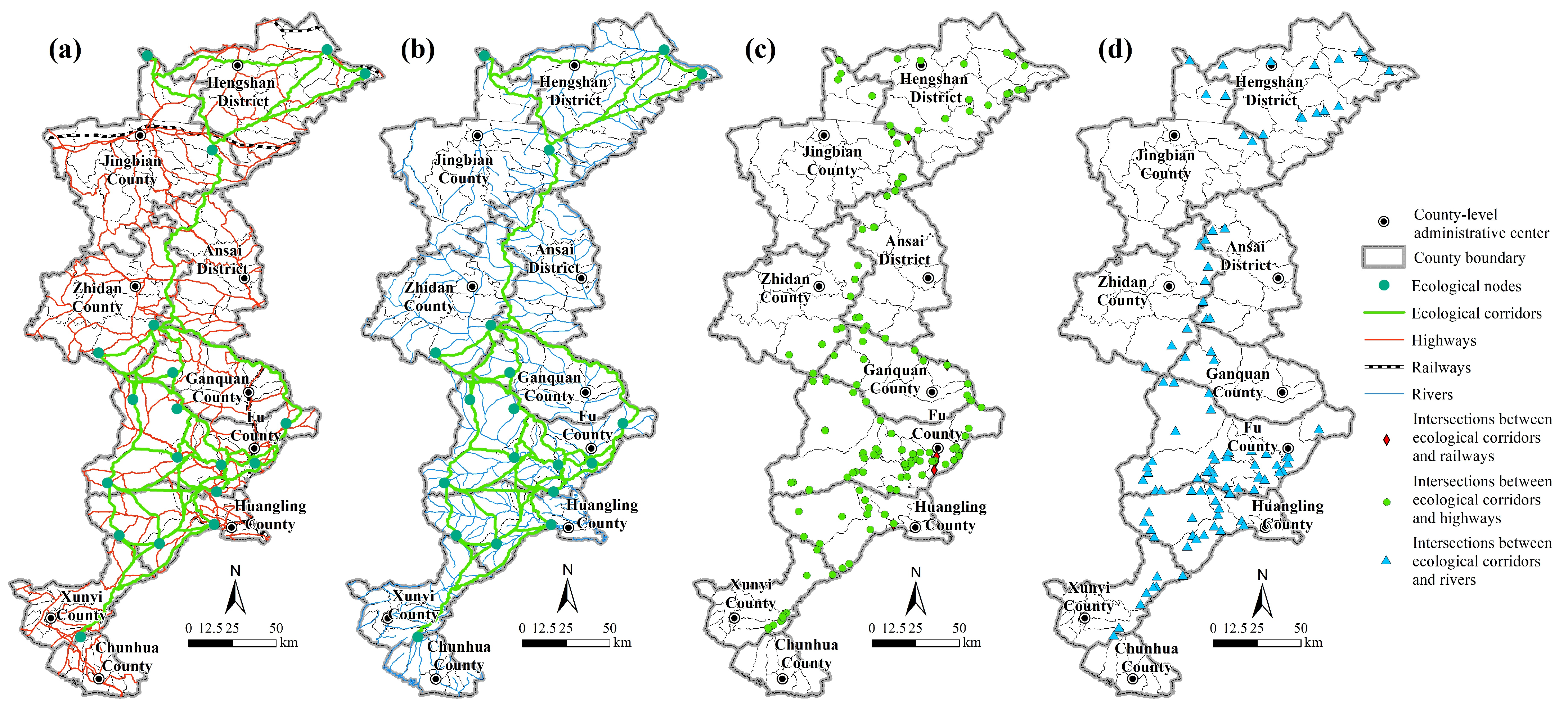
To determine the spatial conflicts of various landscape corridors, it is essential to pay a particular focus on the interactions among the existing gray corridors (roads), blue corridors (rivers), and green ecological corridors (shade zones, green belts, recreational greenways). Therefore, we compared the spatial orientation of these three kinds of landscape corridors in the study area. We found that the various corridors intersected with each other frequently, causing spatial conflicts (Figure 6). Since railways were mostly east–west oriented, it was difficult to avoid their intersections with the ecological corridors connecting the northern and southern ecological sources. In total, there were seven intersections between railways and ecological corridors, mainly in Fu County and Jingbian County. The densely distributed highway network showed 135 intersections with ecological corridors, mainly in Fu County, Huangling County, and Hengshan District, especially at the junction of county units. There were 101 intersections between rivers and ecological corridors, mainly in Fu County and Huangling County. Comparing the distributions of corridor intersections reveals a higher level of consistency between ecological corridors and rivers than between ecological corridors and highways.

3.4.2. Spatial Contrast of Prohibited-Development Areas and Ecological Security Pattern

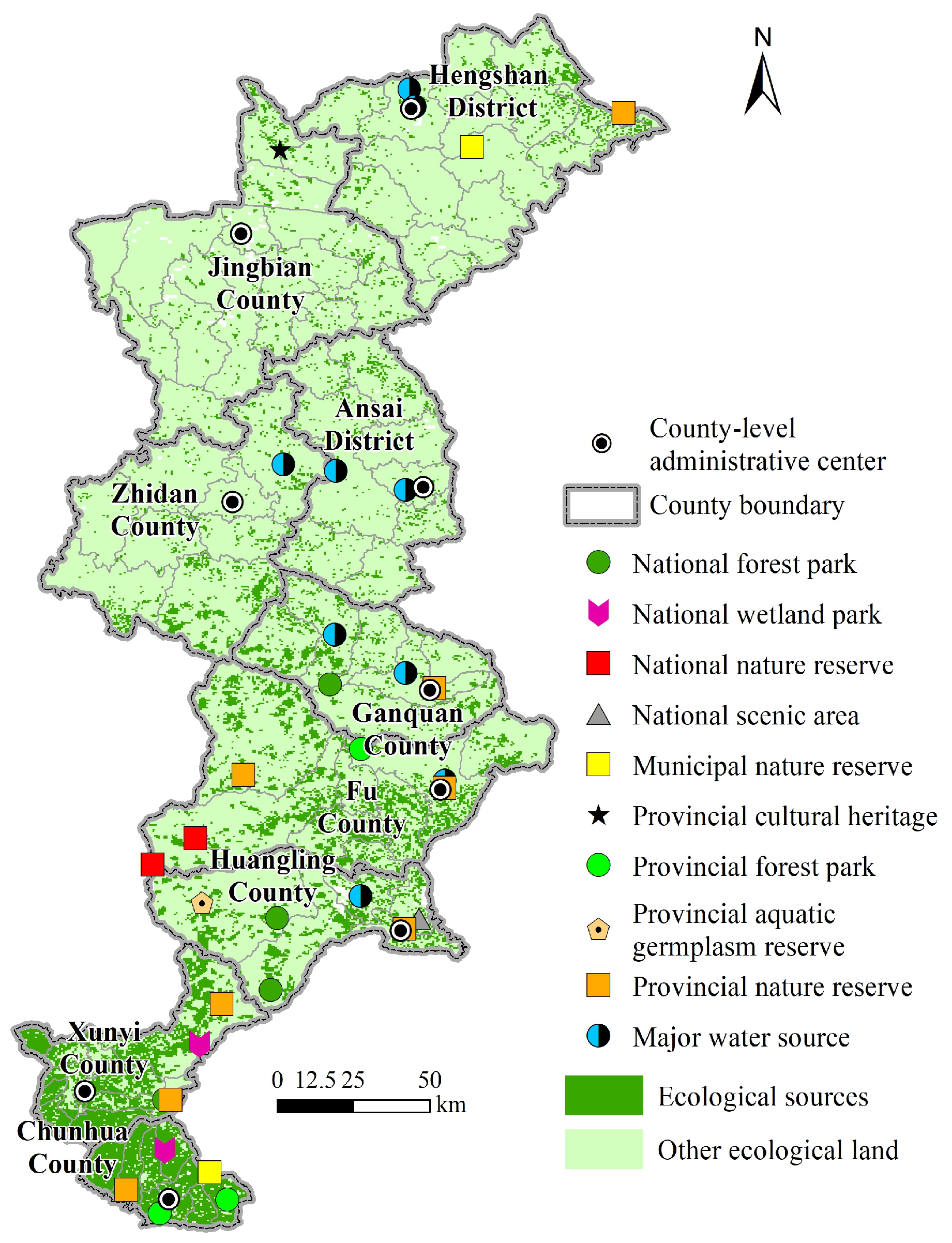
As a key component in the planning of major functional zones, prohibited-development areas are lawfully established natural and cultural resource protection areas prohibited from all forms of industrialization and urbanization development at all levels. Considering that such areas are the key nodes of ecological security pattern and the key objects to be protected in regional construction, we compared the spatial distribution of 33 prohibited-development areas and all ecological sources along the Qin Straight Road (Figure 7). We found that six prohibited-development areas fell completely within the range of ecological sources, which were located in the southern counties of the study area—one national scenic spot, one national wetland park, two provincial forest parks, and two provincial nature reserves. Furthermore, we established 0.5, 1, and 1.5 km wide buffer zones with ecological sources as the center, and found that 16 prohibited-development areas were distributed in the 0.5 km wide buffer zones, most of which were provincial nature reserves and major water sources. In addition, there were six (i.e., one national forest park, two national nature reserve, one provincial aquatic germplasm reserve, one municipal nature reserve, and one major water source) and three (i.e., two major water sources and one national forest park) prohibited-development areas in the 1 km wide and 1.5 km wide buffer zones, respectively. Importantly, two prohibited-development areas (major water sources in Hengshan District and Ansai District) did not match the spatial range of any ecological resources or buffer zones, which called for priority conservation in future ecological construction.

4. Discussion

4.1. Solutions to the Conflicts between Human Activities and Ecological Landscapes

Large-scale human activities and urban-rural infrastructure construction have had a significant impact on the spatial pattern of regional ecological landscapes, which would lead to the fragmentation of continuous ecological sources; meanwhile, the traffic network would also divide the ecological corridors, affecting the diffusion of species and biodiversity [59]. Since it is difficult to dismantle large transportation facilities such as railways and expressways, in order to alleviate the spatial blockage of ecological corridors by road networks, biological migration channels in the form of tubular culverts, underground and under-bridge passages, and canopy overpasses should be built in the conflict areas [60]. At the same time, measures such as setting up warning signs and prohibiting honking should be taken to minimize the impact of urban traffic on biological migration. In fact, a dozen ecological corridors were distributed along rivers in the study area, which demonstrated the key role of river systems in species migration and ecological resource and information flows. Therefore, in view of the intersection of rivers and ecological corridors, ecological corridors should be planned closely based on the direction of natural water bodies, and the opportunities for species flow should be enhanced by increasing waterfront greening and appropriately diverting water to form ponds and wetlands.
In addition, the identification of an ecological security pattern could provide guidance for rational infrastructure construction and ecological restoration along the Qin Straight Road in the future. As the government develops new road plans or expands roadways, the maps of conflicts of landscape corridors could showcase areas where extra care might be needed to avoid impacts to sensitive ecological or cultural resources, as well as inform where new corridors could be revitalized or restored [61]. Specifically, when building the road networks, ecological corridors should be avoided in the form of viaducts or tunnels, while maintaining a sufficient width of vegetation buffer zones on both sides of the roads. At the same time, during the site selection of the infrastructure construction, it is necessary to properly avoid the prohibited-development areas specified in major functional zones, and there should be a safe buffer distance between such areas and the locations selected for culture route development and landscape construction. In addition, the stepping-stone landscapes could provide temporary resting places for biological migration [62]. In the future, small patches of stepping stones should be appropriately supplemented in areas with a low density of ecological sources and corridors along the Qin Straight Road, so as to increase the possibility of biological flow between different ecological sources.

4.2. Direction of Ecological Conservation and Cultural-Landscape Construction

In order to promote culture route development and landscape construction as well as the ecological conservation of the Qin Straight Road in a more targeted manner, the ‘spotty–linear–areal’ landscape elements in key areas should be supplemented by taking into account the current status of ecological security pattern and the needs of linear cultural-heritage utilization.
With respect to spotty-landscape construction, it is suggested that proper development should be carried out on the basis of the strict protection of the original cultural-heritage features along the Qin Straight Road to address the problem that the spatial distribution of ecological nodes along the Qin Straight Road was highly unbalanced, and key nodes were seriously missing in the northern region. One to two new ecological nodes should be added in each of Ansai District, Ganquan County, Xunyi County, Chunhua County, to realize the complete coverage of spotty ecological landscapes in the whole region. Then, based on the rational plan of the spatial locations of new nodes [63], a ‘spotty–linear’ landscape connectivity pattern could be established. Furthermore, great effort should be made to minimize spatial conflicts between green corridors and gray/blue corridors by reducing their total intersection number to <50.
As for linear landscape construction, it is necessary to construct a comprehensive corridor system that can effectively connect the important ecological and cultural landscapes along the Qin Straight Road [64]. On the one hand, the existing road network should be supplemented with priority to increase the connection of key nodes in the cultural landscape while ensuring the supporting role of existing gray corridors in regional economic exchange and population circulation. On the other hand, emphasis lies in adding east–west-oriented countryside and ecological landscape corridors in Jingbian County, Zhidan County, and Ansai District, as well as urban landscape corridors that link urban built-up land and rural residential land in Xunyi County and Chunhua County.
Regarding aerial landscape construction, attention should be paid to increase ecological source areas to 20–30% of the total study area. To this end, the formation of ecological source clusters in the eastern part of Fu County, the eastern part of Huangling County, Fu County, the junction of Ganquan County and Zhidan County, and the northeastern part of Hengshan County is recommended. Ecological sources need to be supplemented in the northern region along the Qin Straight Road given its low coverage of ecological sources. The stress is laid on the eastern part of Jingbian County and the northern part of Ansai District, where the regional ecological security level can be improved by afforestation, landscape pattern reconstruction, and green infrastructure construction. When developing and demonstrating the culture route of the Qin Straight Road, the priority is to build provincial and municipal nature reserves, forest parks, and country parks based on existing ecological sources, and to construct new aerial ecological landscapes in counties and districts that lack nature reserves and ecological parks (e.g., Jingbian County, Zhidan County, Ansai District).

4.3. Active Utilization of Linear Cultural Heritage

4.3.1. Objectives and Principles

Based on our assessment results and the construction demand of the culture route, this study clarified the direction of ecological conservation and cultural landscape construction along the Qin Straight Road. Key areas for the active utilization and construction of linear cultural heritage along the Qin Straight Road in the future need to be extracted based on the principle of coordinating ecological conservation and construction development. It is mainly aimed at adding new areal ecological landscapes such as forest parks and country parks, and new linear landscape corridors such as ecological, countryside, and urban-landscape corridors.
The location selection of key construction projects for areal ecological landscapes should comply with the following principles: first, give priority to the areas having a high coverage of ecological sources and natural vegetation; second, select the areas not far from the heritage sites of the Qin Straight Road, so as to form a complex of cultural and natural landscapes; third, avoid the prohibited-development areas in major functional zones; and fourth, select the areas not far from existing roads or rivers and not spatially divided by them, so as to improve the accessibility of cultural and tourism activities. With regard to linear landscape corridors, the objectives and principles for the location selection of key construction projects and the planning of corridor orientation are as follows: first, give priority to connecting the key construction-project areas of new areal ecological landscapes with the heritages of the Qin Straight Road and existing national or provincial nature reserves and ecological parks; second, avoid the prohibited-development areas in major functional zones; third, avoid ecological-corridor intersections with existing roads and rivers; and fourth, avoid existing built-up land and rural residential land in urban and countryside areas.

4.3.2. Planning and Development Suggestions for Key Construction Projects

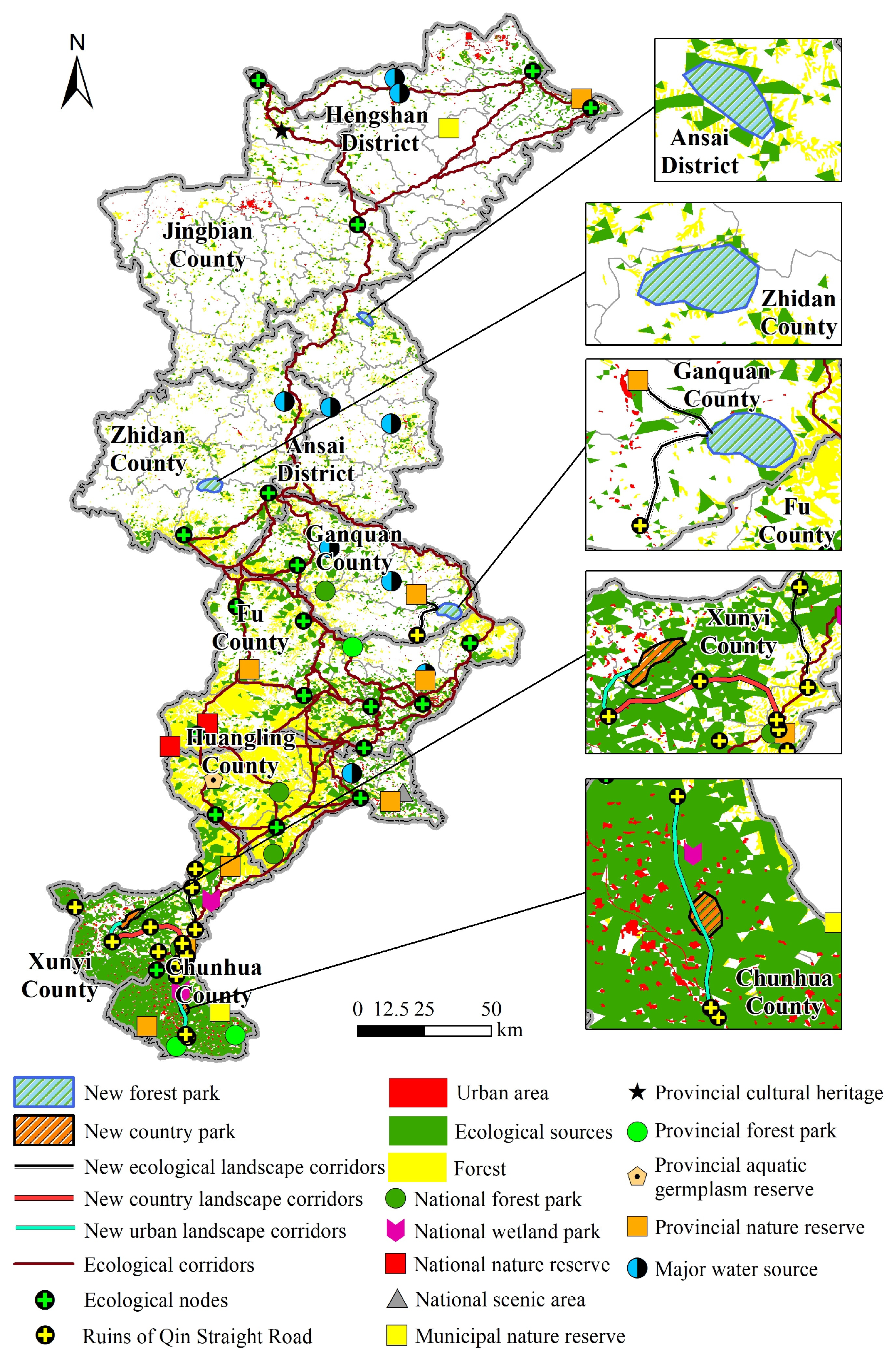
Based on the objectives and principles for key project construction and location selection, we determined the projects of areal ecological landscapes and linear landscape corridors that need to be constructed with priority along the Qin Straight Road in Shaanxi Province in the future (Figure 8). Specifically, we propose the construction of five parks (two country parks, three forest parks) and six landscape corridors (two urban, one countryside, and three ecological landscape corridors) along the Qin Straight Road. The total planned area of new parks is 98.45 km2, which consists of 28.38 km2 of municipal country parks and 70.07 km2 of provincial forest parks. The total planned length of new landscape corridors is 101.26 km, with 32.08 km of urban landscape corridors, 26.49 km of countryside landscape corridors, and 42.69 km of ecological landscape corridors (Table 3).
Furthermore, we propose the following suggestions for the implementation of each type of the construction projects. (1) The construction of country parks should be adjacent to the heritage sites of Qin Straight Road and the surrounding settlements. Before the implementation of the planning, the suggestions of the surrounding residents on the protection and development of the culture heritages, as well as their needs for the construction of country parks, should be investigated, so as to build a daily leisure place integrating the local folk characteristics and the cultural genes of Qin Straight Road. (2) The focus of forest parks construction is to solve the problem of lack of local ecological sources rely on the high-quality natural environment. At the same time, it is also necessary to create a cultural regimen base by combing the local characteristic industries with the cultural characteristics of Qin Straight Road. (3) The urban landscape corridors are close to the central urban area, which aims to connect the surrounding heritages of Qin Straight Road. It is suggested to construct the hotels and museums with cultural characteristics along the corridor, so as to provide urban residents with cultural leisure places with high accessibility. (4) The key point of the construction of countryside landscape corridors is to connect the heritages of Qin Straight Road with the aforementioned country parks. (5) The purpose of the construction of ecological landscape corridors is to connect the aforementioned forest parks on the basis of fully displaying the original features of the Qin Straight Road. And it is suggested to build pedestrian walkways and cycling tracks to promote the development of sports events with local cultural characteristics.
The supplementation and construction of key projects could lead to the formation of a functional and networked ecological–cultural spatial-structure system along the Qin Straight Road in Shaanxi Province. North–south-oriented ecological corridors still form the central ecological belt, from which many ecological corridors extend. The newly planned landscape corridors would not only supplement the original ecological network, but also connect the cultural landscape of the Qin Straight Road and the natural landscape of the study area. Additionally, the aerial ecological landscape clusters existing in the southern and northern regions, together with the newly planned ecological parks in the central region, would form a key ecological green center covering the whole region. While providing important ecosystem services (e.g., water conservation, habitat maintenance, soil retention, carbon sequestration and oxygen release), this ecological green center could create a natural landscape with a high ornamental value. In summary, the proposed location selection of key construction projects for the active utilization of the Qin Straight Road in Shaanxi Province is scientific and practicable.

5. Conclusions

This study identified 45 ecological corridors with a total length of 2938.49 km along the Qin Straight Road in Shaanxi Province, China. These corridors spanned several counties from south to north, effectively connected ecological sources in the study area, and played a bridging role in species migration and energy flow among source areas. More than >90% of the total study area was ecological land, with ecological sources (17.82%) mainly distributed along Ziwuling Mountain, Laoshan Mountain, and Hengshan Mountain. Given their high vegetation coverage, abundant wildlife, and significant ecosystem service value, these source areas were essential to regional and even provincial ecological security. Spatial conflicts were observed between various landscape corridors in the study area. There were seven intersections between ecological corridors and railways, mainly in Fu County and Jingbian County. Additionally, 135 and 101 intersections were found to emerge between ecological corridors and highways, as well as between ecological corridors and rivers, respectively, mainly in Fu County and Huangling County. The ecological corridors showed a higher consistency with rivers than with highways, and a dozen of corridors were orientated along the direction of rivers.
The ecological security pattern in the study area was established in this study, which has great implications for maintaining or controlling the ecological processes in specific areas along the Qin Straight Road. Taking into account the construction demand of the culture route, we clarified the direction of ecological conservation and landscape construction in the study area. Key areas for the active utilization of the Qin Straight Road in the future were extracted based on the principle of coordinating ecological conservation with construction and development. A plan was put forward to build five parks and six landscape corridors for supplementation. The total area of newly planned parks was 98.45 km2, with 28.38 km2 of municipal country parks and 70.07 km2 of provincial forest parks. The total length of newly planned landscape corridors was 101.26 km, with 32.08 km of urban landscape corridors, 26.49 km of countryside landscape corridors, and 42.69 km of ecological landscape corridors. The construction of key projects proposed in this study could lead to the formation of a functional and networked ecological–cultural spatial structure system along the Qin Straight Road in Shaanxi Province.
This study innovatively proposed a protection and utilization plan of linear cultural heritages combined with the regional ecological security pattern, which had certain referential significance in its conception and methods. In terms of conception, this proposal was not limited to the traditional concerns about the heritage value, heritage components, and cultural relics conservation. However, it is a comprehensive plan that fully integrated regional natural background, ecological security construction and cultural heritage active utilization, which is more suitable for the practical needs of cultural heritage researches. Meanwhile, the methods proposed in this study had a clear operating flow, and the datasets involved are easy to obtain, which has good potential for practical application, and would be suitable for promotion in other regions and countries.
In addition, this study provided some ecological ideas for promoting the construction of linear cultural-heritage corridors, combined with the practical application needs, further work should be carried out in the following directions in the future. First, on the basis of determining the location of key construction and protection projects, how to make their specific ranges and spatial directions more reasonable requires extensive field research and suggestions from relevant planning and cultural protection departments. Second, in addition to the analysis based on multi-source dataset, the classification of key construction projects also needs to ask for the needs of residents around cultural heritages for related construction projects through questionnaires or multi-subject interviews. Third, the joint participation and inspection of landscape architects, cultural-heritage protection experts, and urban- and rural-planning scholars are needed in the specific implementation stage of development and construction.

Author Contributions

Conceptualization, T.Z. and X.C.; methodology, H.L.; software, T.Z.; validation, L.Y. and T.Z.; formal analysis, T.Z.; investigation, H.L. and L.Y.; resources, T.Z.; data curation, T.Z.; writing—original draft preparation, H.L. and T.Z.; writing—review and editing, X.C.; visualization, H.L.; supervision, L.Y.; funding acquisition, X.C. and T.Z. All authors have read and agreed to the published version of the manuscript.

Funding

This research was funded by the National Natural Science Foundation of China (Grant No. 41831284), the National Natural Science Foundation of China (Grant No. 42001097), and the Shaanxi Province Association for Science and Technology Youth Talent Support Program (Grant No. 20230710).

Data Availability Statement

The original contributions presented in the study are included in the article, further inquiries can be directed to the corresponding author.

Conflicts of Interest

The authors declare no conflict of interest.

References

  1. Wu, Z.; Ma, J.; Zhang, H. Spatial reconstruction and cultural practice of linear cultural heritage: A case study of Meiguan Historical Trail, Guangdong, China. Buildings 2023, 13, 105. [Google Scholar] [CrossRef]
  2. Zhang, S.Y.; Liu, J.M.; Pei, T.; Chan, C.S.; Wang, M.D.; Meng, B. Tourism value assessment of linear cultural heritage: The case of the Beijing–Hangzhou Grand Canal in China. Curr. Issues Tour. 2023, 26, 47–69. [Google Scholar] [CrossRef]
  3. Shan, Q. On the protection of large-scale linear cultural heritage: Breakthrough and pressure. Cult. Relics South China 2006, 3, 2–5. [Google Scholar] [CrossRef]
  4. Yu, K. China faces the challenge of world heritage concept: Thoughts after the 28th World Heritage Convention. Chin. Landsc. Archit. 2004, 11, 68–70. [Google Scholar]
  5. Ren, H.L. On value evaluation of tourism resource of cross-regional linear cultural heritage: Taking the routes network of Chang’an-Tianshan corridor in China as an example. Sci. Geogr. Sin. 2017, 37, 1560–1568. [Google Scholar] [CrossRef]
  6. Li, F. Study on spatial structure evolution of linear cultural heritage: On the role of tourism. Geogr. Geo-Inf. Sci. 2019, 35, 133–140. [Google Scholar] [CrossRef]
  7. Cucco, P.; Maselli, G.; Nesticò, A.; Ribera, F. An evaluation model for adaptive reuse of cultural heritage in accordance with 2030 SDGs and European Quality Principles. J. Cult. Herit. 2023, 59, 202–216. [Google Scholar] [CrossRef]
  8. Lin, Q.; Lian, Z. On protection of intangible cultural heritage in China from the intellectual property rights perspective. Sustainability 2018, 10, 4369. [Google Scholar] [CrossRef] [Green Version]
  9. Flink, C.A.; Searns, R.M. Greenways: A Guide to Planning, Design, and Development; Island Press: Washington, DC, USA, 1993; p. 352. [Google Scholar]
  10. Wang, F.; Lian, H. Research on progress and developmental tendency of the linear space. Huazhong Archit. 2007, 7, 88–91. [Google Scholar] [CrossRef]
  11. Yu, K.J.; Xi, X.S.; Li, D.H.; Li, H.L.; Liu, K. On the construction of the national linear culture heritage network in China. Hum. Geogr. 2009, 24, 11–16+116. [Google Scholar] [CrossRef]
  12. Shan, Q.X. Cultural heritage protection shows six major trends. Xinhua Daily, 13 April 2007. [Google Scholar]
  13. Wang, L. Value of the ancient Yunnan-Tibet Tea-Horse Road in the perspective of the heritage corridor. J. Yunnan Natl. Univ. 2012, 29, 34–38. [Google Scholar] [CrossRef]
  14. Zhu, H.; Zhao, R.; Xi, T.D. The protection research on lineal cultural heritages of Chinese Canal from cultural routes: A Case of Anhui Section of Chinese Canal of Sui and Tang Dynasty. Hum. Geogr. 2013, 28, 70–73. [Google Scholar] [CrossRef]
  15. Qiao, D.S.; Feng, B.; Zhai, H.M. A preliminary discussion about the new approach of protecting and planning Guilin heritages. Tour. Trib. 2007, 22, 28–31. [Google Scholar] [CrossRef]
  16. Wang, Y.; Wu, D.T.; Zhu, T.X. The “harmony with distinctiveness” in tourism development based on the case of the Silk Road. Hum. Geogr. 2011, 26, 128–132. [Google Scholar] [CrossRef]
  17. Du, Z.; Liu, Y. Comprehensive analysis of the tourism value of linear heritage corridor in the Silk Road on the northwestern China. Arid. Land Geogr. 2011, 34, 519–524. [Google Scholar] [CrossRef]
  18. Li, W.; Yu, K.J.; Li, D.H. The theoretical framework of heritage corridor and the Grand Canal. Urban Probl. 2004, 26, 128–132. [Google Scholar] [CrossRef]
  19. Jia, B.J.; Li, J.W.; Wang, X.H. A study on the spatial distribution characteristics of towns along the Silk Road. Hum. Geogr. 2012, 20, 103–106. [Google Scholar] [CrossRef]
  20. Wang, L.G.; Tao, L.; Zhang, L.J.; Li, J. Study on cultural corridor extent calculation and the construction of its tourism spatial structure—A case study of the southwestern Silk Road. Hum. Geogr. 2012, 128, 36–42. [Google Scholar] [CrossRef]
  21. Zhang, H.Z.; Shen, X.W.; Gao, J. Spatial structure of the leisure zone in urban waterfront: A case study of the Grand Canal in Downtown Hangzhou. Geogr. Res. 2011, 30, 1891–1900. [Google Scholar] [CrossRef]
  22. Witte, A. “Chinese don’t walk?”—The emergence of domestic walking tourism on China’s Ancient Tea Horse Road. J. Leis. Res. 2020, 52, 424–445. [Google Scholar] [CrossRef]
  23. Lee, J.A.; Chon, J.; Ahn, C. Planning landscape corridors in ecological infrastructure using least-cost path methods based on the value of ecosystem services. Sustainability 2014, 6, 7564–7585. [Google Scholar] [CrossRef] [Green Version]
  24. Vollmer, D.; Prescott, M.F.; Padawangi, R.; Girot, C.; Grêt-Regamey, A. Understanding the value of urban riparian corridors: Considerations in planning for cultural services along an Indonesian river. Landsc. Urban Plan. 2015, 138, 144–154. [Google Scholar] [CrossRef]
  25. Shishmanova, M.V. Cultural tourism in cultural corridors, itineraries, areas and cores networked. Procedia Soc. Behav. Sci. 2015, 188, 246–254. [Google Scholar] [CrossRef] [Green Version]
  26. Shi, N. The exploration of the relics of the Qin Shihuang’s Straight Road. Cult. Relics 1975, 10, 44–67. [Google Scholar] [CrossRef]
  27. Wang, Z. Presumption about Wang Zhaojun’s Northbound Route. J. Northwest Univ. Philos. Soc. Sci. Edit. 2014, 44, 17–25. [Google Scholar] [CrossRef]
  28. Wei, Z.; Jian, Z.; Sun, Y.; Pan, F.; Han, H.F.; Liu, Q.H.; Mei, Y. Ecological sustainability and high-quality development of the Yellow River Delta in China based on the improved ecological footprint model. Sci. Rep. 2023, 13, 3821. [Google Scholar] [CrossRef]
  29. Zhang, Z.; Li, Q.; Hu, S. Intangible cultural heritage in the Yellow River Basin: Its spatial-temporal distribution characteristics and differentiation causes. Sustainability 2022, 14, 11073. [Google Scholar] [CrossRef]
  30. Henareh Khalyani, A.; Mayer, A.L.; Webster, C.R.; Falkowski, M.J. Ecological indicators for protection impact assessment at two scales in the Bozin and Marakhil protected area, Iran. Ecol. Indic. 2013, 25, 99–107. [Google Scholar] [CrossRef]
  31. Estoque, R.C.; Murayama, Y. A worldwide country-based assessment of social-ecological status (c. 2010) using the social-ecological status index. Ecol. Indic. 2017, 72, 605–614. [Google Scholar] [CrossRef]
  32. Liquete, C.; Kleeschulte, S.; Dige, G.; Maes, J.; Grizzetti, B.; Olah, B.; Zulian, G. Mapping green infrastructure based on ecosystem services and ecological networks: A Pan-European case study. Environ. Sci. Policy 2015, 54, 268–280. [Google Scholar] [CrossRef]
  33. Abass, K.; Buor, D.; Afriyie, K.; Dumedah, G.; Segbefifi, A.Y.; Guodaar, L.; Garsonu, E.K.; Adu-Gyamfifi, S.; Forkuor, D.; Ofosu, A.; et al. Urban sprawl and green space depletion: Implications for flood incidence in Kumasi, Ghana. Int. J. Disaster Risk Reduct. 2020, 51, 101915. [Google Scholar] [CrossRef]
  34. Yang, T.R.; Kuang, W.H.; Liu, W.D.; Liu, A.L.; Pan, T. Optimizing the layout of eco-spatial structure in Guanzhong urban agglomeration based on the ecological security pattern. Geogr. Res. 2017, 36, 441–452. [Google Scholar]
  35. Peng, J.; Pan, Y.J.; Liu, Y.X.; Zhao, H.J.; Wang, Y.L. Linking ecological degradation risk to identify ecological security patterns in a rapidly urbanizing landscape. Habitat Int. 2018, 71, 110–124. [Google Scholar] [CrossRef]
  36. Efthimiou, N.; Lykoudi, E.; Psomiadis, E. Inherent relationship of the USLE, RUSLE topographic factor algorithms and its impact on soil erosion modelling. Hydrol. Sci. J. 2020, 65, 1879–1893. [Google Scholar] [CrossRef]
  37. Ren, Z.Y.; Liu, Y.X. Estimating the ecological effect of soil conservation by vegetation in northwest China. Resour. Sci. 2013, 35, 610–617. [Google Scholar]
  38. Kouli, M.; Soupios, P.; Vallianatos, F. Soil erosion prediction using the Revised Universal Soil Loss Equation (RUSLE) in a GIS framework, Chania, Northwestern Crete, Greece. Environ. Geol. 2009, 57, 483–497. [Google Scholar] [CrossRef]
  39. Knaapen, J.P.; Scheffffer, M.; Harms, B. Estimating habitat isolation in landscape planning. Landsc. Urban Plan. 1992, 23, 1–16. [Google Scholar] [CrossRef]
  40. Peng, J.; Li, H.L.; Liu, Y.X.; Hu, Y.N.; Yang, Y. Identification and optimization of ecological security pattern in Xiong’an New Area. Acta Geogr. Sin. 2018, 73, 701–710. [Google Scholar] [CrossRef]
  41. Feng, Y.W.; Zhen, J.H.; Ma, C.Y. Evaluation of ecological carrying capacity and optimization of ecological security pattern in Inner Mongolia. Geogr. Res. 2021, 40, 1096–1110. [Google Scholar] [CrossRef]
  42. Yu, K.J.; Wang, S.S.; Li, D.H. The function of ecological security patterns as an urban growth framework in Beijing. Acta Ecol. Sin. 2009, 29, 1189–1204. [Google Scholar] [CrossRef]
  43. Yu, H.; Zeng, H.; Jiang, Z.Y. Study on distribution characteristics of landscape elements along the terrain gradient. Sci. Geogr. Sin. 2001, 21, 64–69. [Google Scholar]
  44. Feng, Y.W.; Zhen, J.H.; Feng, Y.; Tao, Y.; Ma, C.Y.; Han, S. Method and demonstration of urban growth boundary delimitation in arid regions: A case study of Hohhot city, Inner Mongolia. Econ. Geogr. 2019, 39, 76–83. [Google Scholar] [CrossRef]
  45. Li, Y.C.; Liu, C.X.; Zhao, C.Y.; Wang, C.J.; Zhang, H.; Min, J.; Wang, Y. Assessment and spatial differentiation of sensitivity of soil erosion in Three Gorges Reservoir area of Chongqing. Acta Ecol. Sin. 2009, 29, 788–796. [Google Scholar]
  46. Liu, S.H.; Wang, D.Y.; Li, H.; Li, W.B.; Wu, W.J.; Zhu, Y.L. The ecological security pattern and its constraint on urban expansion of a black soil farming area in northeast China. ISPRS Int. J. Geo-Inf. 2017, 6, 263. [Google Scholar] [CrossRef] [Green Version]
  47. Ye, H.; Yang, Z.P.; Xu, X.L. Ecological corridors analysis based on MSPA and MCR model-a case study of the Tomur World Natural Heritage region. Sustainability 2020, 12, 959. [Google Scholar] [CrossRef] [Green Version]
  48. Hilty, J.L.; Lidicker, W.M.; Merenlender, A.M. Corridor Ecology: The Science and Practice of Linking Landscapes for Biodiversity Conservation; Island Press, Inc.: Washington, DC, USA, 2006. [Google Scholar]
  49. Bennett, G. Linkages in Practice: A Review of their Conservation Value; IUCN: Gland, Switzerland, 2004.
  50. Nielsen, A.; Bascompte, J. Ecological networks, nestedness and sampling effort. J. Ecol. 2007, 95, 1134–1141. [Google Scholar] [CrossRef]
  51. Jeong, D.; Kim, M.; Song, K.; Lee, J. Planning a green infrastructure network to integrate potential evacuation routes and the urban green space in a coastal city: The case study of Haeundae District, Busan, south Korea. Sci. Total Environ. 2021, 761, 143179. [Google Scholar] [CrossRef]
  52. Peng, J.; Zhao, H.J.; Liu, Y.X.; Wu, J.S. Research progress and prospect on regional ecological security pattern construction. Geogr. Res. 2017, 36, 407–419. [Google Scholar] [CrossRef]
  53. Bennett, G.; Wit, P. IUCN Red List Categories and Criteria; Information Press: Oxford, UK, 2001; pp. 14–17. [Google Scholar]
  54. Samways, M.J.; Pryke, J.S. Large-scale ecological networks do work in an ecologically complex biodiversity hotspot. Ambio 2015, 45, 161–172. [Google Scholar] [CrossRef] [Green Version]
  55. Zhang, Z.Z.; Meerow, S.; Newell, J.P.; Lindquist, M. Enhancing landscape connectivity through multi-functional green infrastructure corridor modeling and design. Urban For. Urban Green 2018, 38, 305–317. [Google Scholar] [CrossRef]
  56. Jenkins, V. Protecting the natural and cultural heritage of local landscapes: Finding substance in law and legal decision making. Land Use Policy 2018, 73, 73–83. [Google Scholar] [CrossRef]
  57. Taylor, K.; Lennon, J. Cultural landscapes: A bridge between culture and nature? Int. J. Herit. Stud. 2011, 17, 537–554. [Google Scholar] [CrossRef]
  58. Thomson, L.J.; Gordon-Nesbitt, R.; Elsden, E.; Chatterjee, H.J. The role of cultural, community and natural assets in addressing societal and structural health inequalities in the UK: Future research priorities. Int. J. Equity Health 2021, 20, 249. [Google Scholar] [CrossRef] [PubMed]
  59. Nie, W.B.; Shi, Y.H.; Siaw, M.J.; Yang, F.; Wu, R.W.; Wu, X.K.; Zheng, X.Y.; Bao, Z.Y. Constructing and optimizing ecological network at county and town scale: The case of Anji County, China. Ecol. Indic. 2021, 132, 108294. [Google Scholar] [CrossRef]
  60. Zhou, D.; Song, W. Identifying ecological corridors and networks in mountainous Areas. Int. J. Environ. Res. Public Health 2021, 18, 4797. [Google Scholar] [CrossRef]
  61. Qian, M.Y.; Huang, Y.T.; Cao, Y.R.; Wu, J.Y.; Xiong, Y.M. Ecological network construction and optimization in Guangzhou from the perspective of biodiversity conservation. J. Environ. Manag. 2023, 336, 117692. [Google Scholar] [CrossRef] [PubMed]
  62. Rocha, É.G.; Brigatti, E.; Niebuhr, B.B.; Ribeiro, M.C.; Vieira, M.V. Dispersal movement through fragmented landscapes: The role of stepping stones and perceptual range. Landsc. Ecol. 2021, 36, 3249–3267. [Google Scholar] [CrossRef]
  63. Shoshany, M.; Shapira, A.; Nir-Goldenberg, S.; Paola, P.D. Progression of greenway corridors through conflict: Cellular automata simulation and AHP evaluation. Environ. Model Assess 2023, 28, 519–533. [Google Scholar] [CrossRef]
  64. Xu, H.Y.; Zhao, G.H.; Fagerholm, N.; Primdahl, J.; Plieninger, T. Participatory mapping of cultural ecosystem services for landscape corridor planning: A case study of the Silk Roads corridor in Zhangye, China. J. Environ. Manag. 2020, 264, 110458. [Google Scholar] [CrossRef]
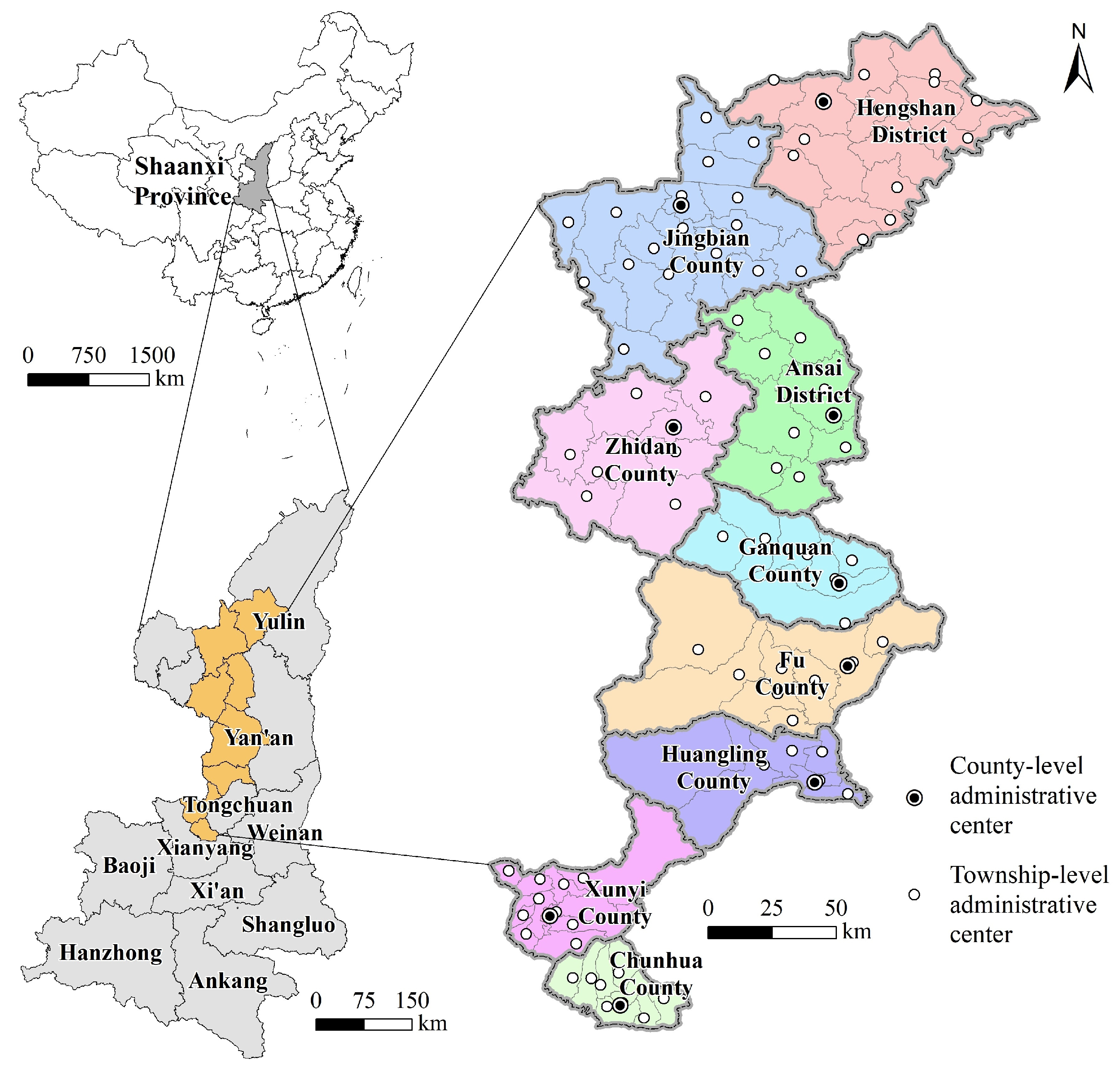
Figure 1. Location and administrative division of the region along the Qin Straight Road in Shaanxi Province.
Land 12 01361 g001
Figure 2. Spatial pattern of four typical ecosystem services, (a) carbon sequestration and oxygen release, (b) water conservation, (c) habitat maintenance, and (d) soil retention, in the study area.
Land 12 01361 g002
Figure 3. Importance of ecosystem services (a) and distribution of ecological sources (b) in the study area.
Land 12 01361 g003
Figure 4. Ecological-resistance surface (a), mean ecological resistance (b), and cumulative cost distance among ecological sources (c) in the study area.
Land 12 01361 g004
Figure 5. Regional ecological security pattern in the study area.
Land 12 01361 g005
Figure 6. Spatial distribution of ecological corridors and gray corridors (roads) (a) and their intersections (c), spatial distribution of ecological corridors and blue corridors (rivers) (b) and their intersections (d) in the study area.
Land 12 01361 g006
Figure 7. Distribution of prohibited-development areas and ecological sources in the study area.
Land 12 01361 g007
Figure 8. Locations for the construction of key projects in the study area.
Land 12 01361 g008
Table 1. Key indicators in the database of regional natural and cultural assets.
Asset TypesIndicatorsInstructions
Natural assetsLand use and land cover typesForest, grassland, cropland, wetland, water bodies, construction land, transportation land, bare area, snow/ice
Typical ecosystem servicesCarbon sequestration and oxygen release, water conservation, habitat maintenance, soil retention
Ecological sourcesConcentrated contiguous high-quality ecological landscapes
with high ecosystem services
Ecological nodesThe center of ecological sources and the junctions of
adjacent ecological corridors
Ecological corridorsThe linkages of ecological sources and nodes
Cultural assetsKey sites of cultural heritage on the Qin Straight RoadName, era, longitude and latitude, photos of heritages, conservation and construction situation, grade of cultural relics protection, protection range and construction control, value assessment
Routes and directions of
Qin Straight Road
Location, length, width, conservation and construction situation, grade of cultural relics protection, protection range and
construction control, value assessment
Social and economic development of the countiesEconomic development, population, urban and rural
construction, traffic network
Development of culture-related
infrastructure
Monument for cultural relics protection, heritage protection fence, heritage signboard, warning signs, museum
Table 2. Key elements in the ecological security pattern of the study area at the county level.
County UnitEcological SourcesEcological CorridorsEcological Nodes
Area (km2)Proportion (%)Length (km)Proportion (%)Number (Node)Proportion (%)
Hengshan District267.616.08 310.97 10.58 210.53
Jingbian County214.204.87 180.11 6.13 210.53
Zhidan County295.436.71 204.10 6.95 210.53
Ansai District186.104.23 175.41 5.97 00
Ganquan County302.246.87 347.42 11.82 15.26
Fu County886.4920.15 1132.15 38.53 736.84
Huangling County450.9110.25 340.87 11.60 315.79
Xunyi County961.7721.86 246.04 8.37 00
Chunhua County835.1418.98 1.42 0.05 00
Note: There is one ecological node at the junction of Huangling County and Fu County, and the junction of Xunyi Cunty and Chunhua County.
Table 3. Basic information of key construction projects in the study area.
Project TypeNameScaleLocation
Landscape corridorUrban Landscape Corridor of the Culture–Ecology of the Qin Straight Road (Xunyi)9.12 kmChengguan Street (Xunyi County)
Landscape corridor Urban Landscape Corridor of the Cultural Heritage of the Qin Straight Road (Chunhua)22.96 kmTiewang Town (Chunhua County)
Landscape corridorCountryside Landscape Corridor of the Cultural Heritage of the Qin Straight Road (Xunyi)26.49 kmChengguan Street (Xunyi County)
Landscape corridorEcological Landscape Corridor of the Natural Scenery of the Qin Straight Road (Xunyi)21.07 kmMalan Town
(Xunyi County)
Landscape corridorEcological Landscape Corridor of the Cultural Heritage of the Qin Straight Road (Ganquan)13.09 kmDao Town
(Ganquan County)
Landscape corridorEcological Landscape Corridor of the Natural Scenery of the Qin Straight Road (Ganquan)8.53 kmMeishui Street
(Ganquan County)
ParkMalanhe Municipal Country Park in Xunyi County (Municipal)19.51 km2Zhitian Town
(Xunyi County)
ParkYeyuhe Municipal Country Park in Chunhua County (Municipal)8.87 km2Tiewang Town (Chunhua County)
ParkBeiluohe Provincial Forest Park in Ganquan County (Provincial)30.59 km2Dao Town
(Ganquan County)
ParkZhouhe Provincial Forest Park in Zhidan County (Provincial)27.71 km2Yongning Town
(Zhidan County)
ParkYanhe Provincial Forest Park in Ansai District (Provincial)11.77 km2Pingqiao Town
(Ansai District)
Disclaimer/Publisher’s Note: The statements, opinions and data contained in all publications are solely those of the individual author(s) and contributor(s) and not of MDPI and/or the editor(s). MDPI and/or the editor(s) disclaim responsibility for any injury to people or property resulting from any ideas, methods, instructions or products referred to in the content.