Article

Enhancing Access to Urban Hill Parks: The Montjuïc Trail Masterplan and the 360° Route Design in Barcelona

by
Josep Mercadé-Aloy
1 and
Marina Cervera-Alonso-de-Medina
2,*
1
Escola Tècnica Superior d’Enginyers de Camins, Canals y Ports de Barcelona, Departament d’Enginyeria Civil i Ambiental, Universitat Politècnica de Catalunya, 08034 Barcelona, Spain
2
Escola Tècnica Superior d’Arquitectura de Barcelona, Departament d’Urbanisme, Territori i Paisatge, Universitat Politècnica de Catalunya, 08028 Barcelona, Spain
*
Author to whom correspondence should be addressed.
Submission received: 12 November 2023 / Revised: 15 December 2023 / Accepted: 17 December 2023 / Published: 19 December 2023
(This article belongs to the Special Issue Landscape Architecture and Design in Urban and Peri-Urban Environment)

Abstract

:
The 2030 United Nations Sustainable Development Goals (SDGs) include ensuring universal and safe access to green spaces. Some cities feature extensive green areas on hills or elevated terrains integrated into the urban landscape. In such cases where the benefits for users are highly pronounced (e.g., views, isolation, etc.), it is challenging and particularly complex to design strategies to ensure accessible and spatial routes due to multiple slopes and a challenging topography. In Barcelona, the iconic Montjuïc mountain has been the focal point of a trail masterplan aimed at rethinking its various access points and internal network of routes. Furthermore, the city has committed to implementing an initial project from this plan, the so-called 360° route. This study presents an in-depth analysis of the Montjuïc mountain case, encompassing both the plan and the 360° project in hilly urban parks. The analysis reveals the values and transferability of the set of strategies proposed in the plan, such as activating inherent location characteristics by connecting the surrounding urban fabric with elements of recreational potential within the underlying traces of heritage value. Additionally, a quantitative assessment of the impact of the proposed accesses on the population is presented. The study highlights the improvements in quality of life for the diverse users of this type of green infrastructure.

1. Introduction

The 2030 United Nations Sustainable Development Goals (SDGs) include “universal access to safe, inclusive, and accessible green and public spaces” as part of their objective 11.7 [1]. The strategic importance of urban parks has been highlighted from multiple perspectives. Beyond providing strictly environmental services (e.g., air or microclimate stabilization), green spaces offer diverse social and psychological benefits [2] that have a positive impact on the health and well-being of residents [3]. Currently, the emphasis is placed on the concept of green infrastructure, which is understood as a planned network of natural and seminatural spaces that provide ecosystem services and protect biodiversity [4]; this includes—and does not diminish—the importance of urban parks of considerable size [5].
Among urban green spaces and parks of some significance, we encounter natural spaces such as mountains, lakes, and rivers that were once on the periphery but have gradually become integrated into the expansion and development of urban areas [6]. Within this range of situations, there exists a specific typology that pertains to hills that have become entrenched within urban areas. While it may seem that hilly environments discourage walking along steep gradients [7], it is also true that various and complementary reasons enhance their recreational potential. Elevated locations significantly contribute to isolation from the city, enhancing parameters such as stress reduction and a sense of peacefulness, as identified in the 1980s by Ulrich [8] and Kaplan [9]; they also provide benefits that are associated with distant views [10]. On the other hand, the strategic nature of elevated locations from the perspective of territorial control and symbolic significance often leads to an intense succession of changing land use patterns that result in a diverse mosaic of cultural ecosystem services [6].
Several examples confirm the importance and uniqueness of such settings in cities. For example, Holyrood Park in Edinburgh is a remarkable 260 hectares of upland landscape in the heart of the capital, shaping its identity and encompassing a range of habitats and heritage [11]. Mount Royal in Montreal covers 280 hectares and is a symbol of the city with its green spaces, heritage, and a range of services and activities [12]. Similarly, the Montjuïc hill in Barcelona, covering 338 hectares, is a symbolic place that combines historical importance, nature, and recreational opportunities [13].
All of these examples share a combination of nature, culture, and recreational services in complex spatial configurations that have a sedimentary nature (i.e., the succession of changing land use patterns), which lead to unstructured mosaics in challenging topographies. Both physical barriers (e.g., [14,15]) and the valuation of cultural ecosystem services (e.g., [16,17,18]) have been considered in assessing the quality of large green spaces. However, the need to organize the built and intangible heritage within complex green spaces has received less research attention.
In this context, trails have been identified as place-narrative tools that can improve visitors’ engagement and contribute to the interpretation of complex green spaces [19,20]. Therefore, it is hypothesized that trail planning is a crucial element in engaging the community to use these large green spaces extensively, overcoming physical barriers and benefiting from a significant and purposeful spatial structure.
This research explores the case study of Montjuïc, Barcelona’s largest and most visited urban park [21], focusing on the recent development of the Montjuïc Trail Masterplan (MTM), which was designed to enhance the system of accesses and itineraries [22]. The aim is to analyze the masterplan to identify planning tools that can be applied to similar situations, namely, unique urban parks located on hills with a significant heritage layout and subject to multiple transformation episodes. Complementarily, an analysis of the 360° route strategy [23] is considered due to its importance in the overall plan and its advanced level of implementation. Finally, a quantitative evaluation of the impact on the population within reach of the proposed access system in the plan is provided.

2. Materials and Methods

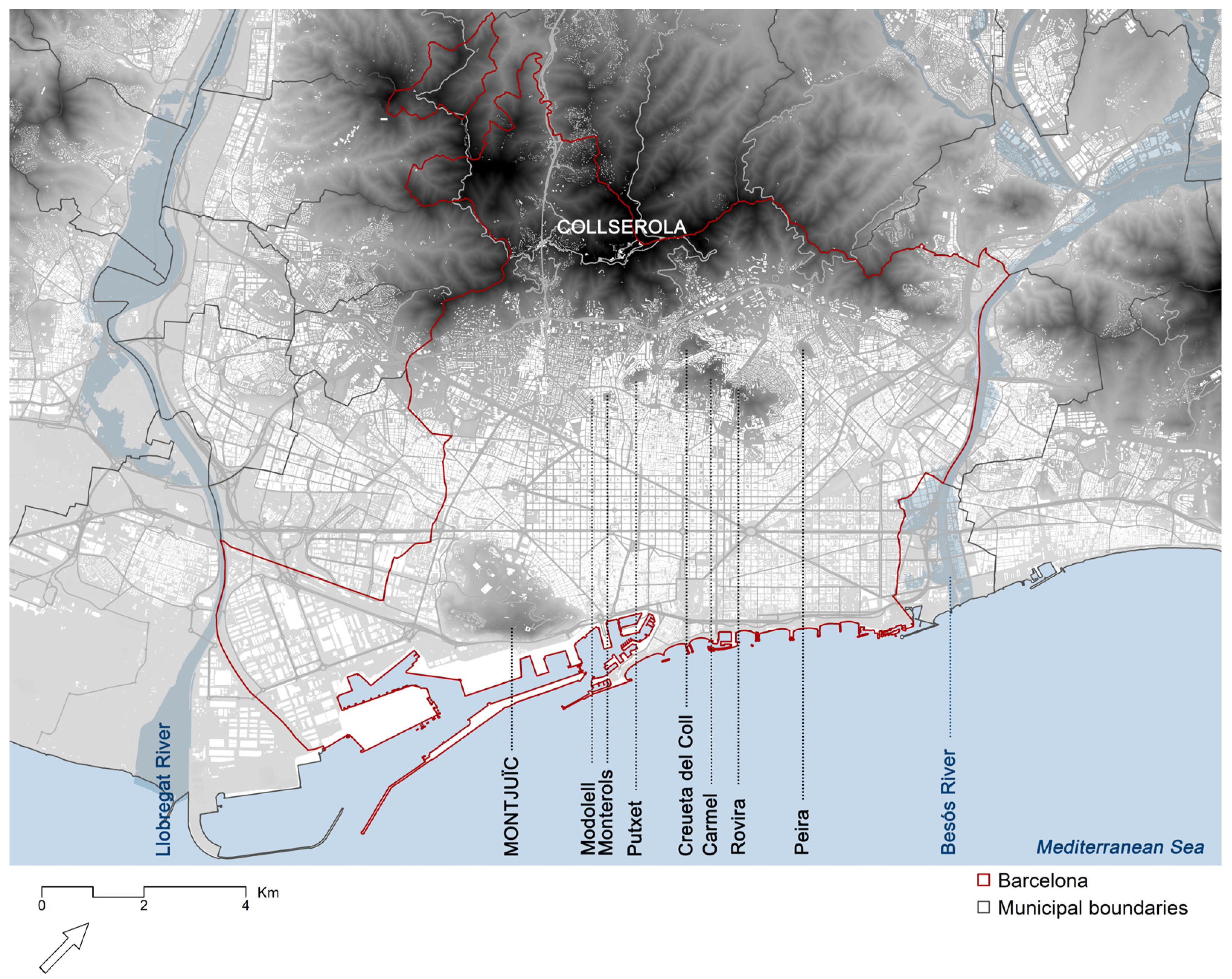
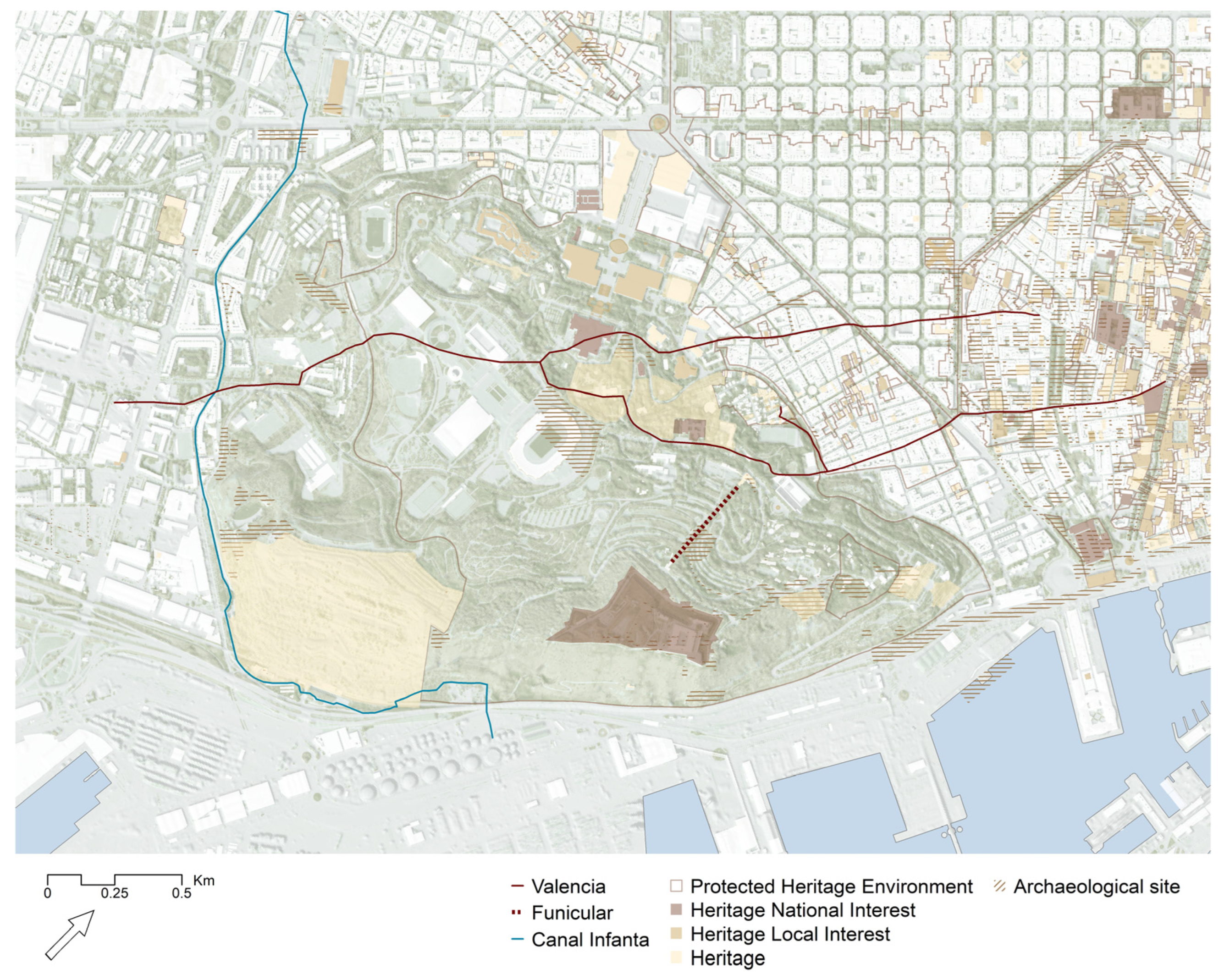
2.1. Case Study: Montjuïc Park in Barcelona, Spain

Barcelona, the capital of Catalonia in Spain, is among the most densely populated cities in Europe with an urban population of approximately 1.7 million. This represents 63% of the Catalan population and 10% of the Spanish population [24]. The city is located on the plain of Barcelona and is bounded by two rivers (Besós and Llobregat), the Montjuïc hill, the Collserola mountain, and the Mediterranean Sea. The city, much like Rome and Lisbon [25], has assimilated seven smaller hills and the Montjuïc hill, which is the largest (Figure 1).
Montjuïc is a 173 m high hill located in the southeastern part of the city, covering an area of 338 ha (Figure 2). This area serves as the focus of the research and corresponds to the limits outlined by the latest update of the Montjuïc land-use masterplan [21]. The hill has a complex orography formed by an irregular cone consisting of three hillsides, one of which is an impressive cliff facing the sea (Morrot) [26].
The hill is an unmistakable landmark that has played a significant role in the city’s development. In fact, the earliest evidence of human settlements in Barcelona was discovered in Montjuïc (Epipalaeolithic), and since the Roman period, it has been utilized as a stone quarry to construct numerous monuments within the city [27]. Ever after, the Montjuïc hill has held strategic significance from a military perspective, providing visual control over the Mediterranean Sea and the city. It was fortified as early as the 17th century. Additionally, the hill has hosted two internationally significant events: the 1929 International Exposition and the 1992 Summer Olympics. The former led to the construction of multiple buildings, such as the National Museum of Catalan Art, the Magic Fountain, and the Spanish Village, among other transformations. The latter resulted in the renovation of existing structures, including the Olympic Stadium, and the addition of new facilities, like the Palau Sant Jordi [13].
Today, the Montjuïc hill comprises a mosaic of multiple attractions and cultural institutions, such as the Fundació Joan Miró and the Jardí Botànic (a botanical garden with over 2000 plant species). It also hosts several festivals and events throughout the year, including the Grec Festival (a summer festival of music, theatre, dance, and circus), the Piromusical (a fireworks show with music), and the Fira de Barcelona (a trade fair) [28].
On the other hand, the Montjuïc hill offers stunning views of Barcelona and its surroundings, especially from its highest point, where the military fortress—the castle—is located. It can be accessed by various means of transportation, such as buses, the metro, a funicular, and a cable car. It is also a popular spot for hiking, biking, and picnicking [13].
However, the hill, with its diverse range of recreational opportunities and cultural attractions, lacks a meaningful structure of trails and accesses that could enhance visitor engagement from an active mobility perspective. The recent MTM [22] addresses this gap and is further analyzed in the article.
Figure 1. The Montjuïc hill’s location in Barcelona—Montjuïc and the seven hills: Modolell, Monterols, Putxet, Creueta del Coll, Carmel, Rovira, and Peira. Source: the authors, based on regional data [29].
Land 13 00002 g001
Figure 2. The Montjuïc hill and the surrounding neighborhoods of Barcelona: (top) floor plan and (bottom) cross-section 1-1′. Source: the authors, based on municipal [30] and regional LIDAR data [29].
Land 13 00002 g002

2.2. Methods

The applied case study methodology encompassed three distinct phases derived from planning and design research approaches grounded in the case-based literature [31]: (1) definition, including the selection of the case study based on the research gap and the hypothesis set out in the first section; (2) preparation, data collection, and analysis of the case study; and (3) elaboration of the synthesis of the findings, leading to further discussion and conclusions (Figure 3).
To address the second phase, a comprehensive analysis was conducted on the MTM [22], with particular focus on the system of accesses and trails it provides. Simultaneously, a review of prior plans, studies, and initiatives related to the MTM [22] was conducted. The most relevant planning instruments included the 2014 Montjuïc Hill Plan [21] and the 2018 Action Plan for Montjuïc Park [32], which are a binding land-use plan and a set of corresponding actions, respectively. Among the notable studies, we found the 2019 Study of Landscape Intervention Strategies for the Montjuïc Paths [33], the 2020 Proposal for Public Space and Mobility for Montjuïc [34], the 2019 Strategic Plan for the Coastal Spaces of the City [35], the 2019 Preliminary Study for the Recovery of the Infanta Canal and the Old Canal [36], and the 2018 Urban Landscape Study Font de la Guatlla [37]. Among the initiatives arising from or involving civil society, the Montjuïc 360° route [23] is particularly noteworthy and, as will be shown, is the first component to be executed following the MTM [22] presentation. A further collection of initiatives can be found within the participatory budget processes that occurred in the neighborhood in 2021 [38].
Additionally, two further insights have been pursued: firstly, a comprehensive exploration of the 360° route [23] as included in the MTM [22], analyzing its physical implementation and impact, and secondly, the computed impact of the MTM [22] accesses, evaluating the number of inhabitants within reach. This approach is solely quantitative and does not encompass economic and social aspects, such as the initiatives’ impact on the local property market [39]. Specifically, the method refers to the intersection between the influence buffers originating from the accesses to the Montjuic hill proposed in the MTM [22], measured along the street network, and the population recorded in the blocks according to the January 2023 census data [40]. This type of approach has been widely used as a measure of proximity in green spaces (i.e., evaluation of the number of users with reference to a certain service) [41].
To establish the catchment areas for each access, travel times of 15 and 30 min along the shortest paths were considered, with a reduced speed of 2 km/h to include most residents (e.g., children and older adults). Studies and manuals on walking accessibility usually set values between 0.75 m/s (2.7 km/h) and 1.22 m/s (4.32 km/h) [42,43,44]. However, when considering an inclusive approach, these values are generally reduced to 2 km/h, as was the case in a recent study carried out for Barcelona by the institution Barcelona Regional [45] in relation to access to urban green spaces.
The distances and travel times considered capture the notion of proximity to the daily or semiweekly visitor but do not take into account the other less frequent use patterns, which would have a considerably larger footprint given the size and importance of Montjuïc Park [43]. In this sense, the hypothesis that the size of a park increases the desire of visitors to use it and therefore to travel greater distances is only valid for those who visit the park occasionally [46]. Moreover, the considered proximity distances and travel times align with the standards of various supranational agencies. For instance, the World Health Organization [47] considers spaces of 0.5–1 hectares at a distance of 300 m (approximately 5 min at a speed of 2 km/h), and the European Environment Agency [48] recommends a 15 min access measure to green spaces. Of greater significance, the proposed analysis integrates the concept of the “15 min city” [49] by incorporating this isochrone within the population evaluation (500 m at a speed of 2 km/h). In addition, a 30 min isochrone (1000 m at a speed of 2 km/h) was considered to overcome two factors: (1) the fact that the park perimeter is often occupied by nonresidential transitional facilities and (2) to implicitly account for a less conservative speed (i.e., 1000 m is actually a 15 min distance at a speed of 4 km/h).
Finally, the accesses were evaluated by merging the 15 min isochrones (500 m) by foot from each access to account for the total population nearby. Another additional check was carried out by recalculating the 15 min isochrones using public transportation, following the trend of extending the notion of the “15 min city” to transit-oriented development [50]. To do this, the General Transit Feed Specification (GTFS) files of the public transportation systems that operate within the study area of the city of Barcelona were utilized for a typical weekday morning. Specifically, the GTFS files of the following operators were used: Direcció General de Transports i Mobilitat (DGTM) [51], Transports Metropolitans de Barcelona (TMB) [52], Ferrocarrils de la Generalitat de Catalunya (FGC) [53], Renfe Operadora [54], and TRAM [55]. All of the modeling, for both walking and using public transportation, was conducted using the network analyst module of ArcGIS Pro [56] considering the vector road network data from OpenStreetMap [57].

3. Results and Discussion

3.1. Analysis of Previous Plans, Studies, and Initiatives before the Masterplan

The studies and planning documents preceding the MTM [22] that form the fundamental framework for developing the new spatial organization can be categorized into three groups: (1) planning instruments exclusively covering the Montjuïc hill, (2) urban studies and sectoral plans, and (3) civil society initiatives. Table 1 outlines the reviewed documents, elucidating their primary objectives, underscoring their contributions to the forthcoming access and trail system of the park, and expounding on their limitations for this purpose.
Among the planning instruments, the 2014 Montjuïc Hill Plan [21] stands out by examining historic pathways in contrast to the present roadways in its diagnosis. From the perspective of land-use planning, it envisions a park with distinct zones: the classic park, the sports park, the natural interest park, and the transformed park. The classic park refers to areas containing heritage-value facilities. The sports park includes buildings and open spaces dedicated to sports. The natural interest park acknowledges protected natural spaces as well as their transitional perimeter areas. The transformed park identifies themed garden areas that should be permeable to users at predetermined times. Additionally, the plan identifies strategic intervention points as measures to facilitate sustainable mobility. Secondly, the 2018 Action Plan for Montjuïc Park [32] revisits the 2014 Montjuïc Hill Plan [21] in conjunction with contributions from entities and organizations with interests in the hill, grouped under the name Montjuïc Park Council. The document primarily develops a set of four key ideas: (1) a park for the neighborhood with citywide projection, (2) a park with diverse spaces to regain the concept of a lung for the city, (3) an accessible park that optimizes mobility, and (4) the development of governance tools.
In addition to the planning in the abovementioned documents, subsequent studies were conducted that are relevant for understanding the starting point of the MTM [22]. For instance, the 2019 Study of Landscape Intervention Strategies for the Montjuïc Paths [33], stemming from the 2018 Action Plan for Montjuïc Park [32], offers an initial approach to proposed itineraries and identifies up to 18 specific intervention points to address accessibility issues.
Furthermore, the 2020 Proposal for Public Space and Mobility for Montjuïc [34] explores the relationship between the city and the hill based on the proposals for green accesses in the city of Barcelona [58] as priority access points to the large park. Within the hill’s interior, there is a specialization and prioritization of the internal road system to discourage private vehicle use in favor of public transportation, cycling, and pedestrian mobility.
Other studies that have a more tangential focus include the 2019 Strategic Plan for the Coastal Spaces of the City [35], which envisions an urban public transportation corridor and a bike lane on the southeastern slope connected to the Port of Barcelona. The 2019 Preliminary Study for the Recovery of the Infanta Canal and the Old Canal [36] evaluates the preservation of the historic infrastructure bordering the southwestern slope of Montjuïc. Lastly, the 2018 Urban Landscape Study Font de la Guatlla [37] focuses on the Font de la Guatlla neighborhood located on the northwestern slope in order to identify its values and establish future strategies, including mitigating topographical fractures and creating a panoramic ridge walkway.
Finally, among the initiatives originating from and/or involving civil society, the route known as Montjuïc 360° [23] and the resolution of the participatory budgets driven by the Sants-Montjuïc district in 2021 [38] are noteworthy. The Montjuïc 360° route [23], which began in 1994, was proposed by the Hiking Promotion of Barcelona to highlight a perimeter route that minimizes its passage through paved streets and maximizes paths through the park, connecting points of interest along its approximately 10 km course. On the other hand, the participatory budgets identified several sets of relevant proposals, emphasizing improving the hillside environment, ecological balance, and pathways.
Table 1 demonstrates that the majority of approaches lack an all-encompassing relational structure to effectively organize the park’s attributes and content via active mobility infrastructure. However, notable progress has been made in recognizing access points, identifying heritage traces, incorporating green infrastructure, and characterizing attractors; this is particularly highlighted in the 2014 Montjuïc Hill Plan [21]. These insights will serve as valuable inputs for the MTM [22], enabling the development of a comprehensive relational structure that encompasses the entirety of the park.

3.2. Analysis of Key Factors Influencing the MTM Proposal: Heritage and Green Infrastructure

Beyond the detailed study of plans, studies, and initiatives related to the park, the MTM [22] stands out for considering two key aspects: heritage and green infrastructure.
In the case of heritage, one of the objectives of the MTM [22] is to activate traces of the site’s relational elements, referred to as heritage infrastructure, in order to become part of the new trail network (Figure 4). To address this consideration, previous studies that drew upon specialized literature enable the identification of up to four main elements: (1) the ancient paths of Montjuïc, (2) the so-called Canal de la Infanta, (3) the Paseo de Jean Forestier, and (4) the Funicular de Montjuïc. Concerning the ancient paths of Montjuïc, specialized literature has emphasized certain traces that are already identifiable through 18th century cartography, medieval texts, and the still recognizable fossilized reality [22]. The most significant set of elements is centered around the toponym of the Camí de València, traversing the hill from southwest to northeast in successive evolutions from an origin believed to be Roman [13]. The Canal de la Infanta represents one of the most valuable heritage infrastructures, although its relationship with the park is somewhat tangential, embracing the southwestern foothill. It was built between 1817 and 1820 to carry water from the Llobregat River to irrigate the left bank of its delta. From the initial agricultural, demographic, and industrial explosion, there was a progressive absorption of the irrigation network by the urban fabric, turning the system into an improvised drainage network. Eventually, it was covered, cut, and redirected according to the needs of each municipality, resulting in a collection of disconnected built heritage elements [36]. The Passeig de Jean Forestier was part of the monumental layout designed for the 1929 International Exhibition of Barcelona. It is now named after Jean Claude Nicolas Forestier, a landscape architect who played a vital role in landscaping Montjuïc’s slope [59]. The Funicular de Montjuïc, with a slightly less than 100 m development, was inaugurated for the 1929 International Exhibition and is currently out of use [60]. The strategy of defining a trail network with heritage content and historical significance goes beyond the conceptualization of a set of tourism products. For instance, MacLeod [19] pointed out that constructing a specific narrative around trails significantly contributes to increased visitors and the appreciation and “active engagement” of local communities.
In the second case of heritage, recognizing a broader framework beyond the mere construction of local urban green infrastructure is involved. The 2018–2030 Climate Plan for the city of Barcelona [61] addresses climate change objectives for the horizon for 2030, including a 40% reduction in CO2 emissions per capita compared to 2055 and an increase in urban greenery by 1.6 km2 (1 m2 per current resident). Among the evidence gathered by this plan, it was noted that Barcelona experienced eight heatwaves in the last 34 years, and from a health perspective, the Sants-Montjuïc district ranks among the worst according to the Urban HEART tool [62]. Focusing on Montjuïc, the document highlights the Montjuïc cliffs as reserves for preserving fauna that are vulnerable to climate change. In addition, the 2021–2030 Nature Plan of Barcelona [63] aims to increase the city’s green infrastructure and identifies Montjuïc as one of the most exciting areas in terms of green spaces and biodiversity concentration.

3.3. The Montjuïc Trail Masterplan Proposals

The MTM [22], drawing from previous plans, studies, and initiatives, conceives a comprehensive trail network that takes into account both heritage and green infrastructure. The new proposal establishes the following: (1) a range of up to 12 city–park access points, including transition transects between urban fabrics and the hill; (2) a closed circuit called Montjuïc 360° [23] inspired by the mentioned contribution of the Hiking Promotion of Barcelona, which encompasses all access points; (3) a set of five trails linked to historical traces; and (4) a set of future connection provisions that the plan does not consider a priority. In the case of the five historical trails that are reinterpreted, they include those mentioned in the previous subchapter: (a) Funicular, (b) Valencia, (c) Sta Madrona, (d) Forestier, and (e) Canal de la Infanta. The proposed network is capable of integrating the considerations made by previous studies and is represented as if it were a public transportation network following examples like Metrominuto in Pontevedra, Spain [64], or the Cambio Network of cycle highways in Milan [65]. The new layout, which is represented in Figure 5, allows the categorization of nodes into (1) interchange nodes between lines, (2) link nodes between access points and the itinerary network, and (3) points of interest. The names of the lines and nodes correspond to their heritage infrastructure reference and the most representative toponyms within their respective areas of influence.
In conjunction with the overall scheme, an identification of the necessary physical interventions was carried out to formalize the proposal, ensuring an acceptable level of accessibility. To synthesize the future interventions, the range of development actions was narrowed down, including intensive urbanization, light green area development, and pathway conditioning. Infrastructure-related actions, such as escalators, elevators, and stairs, were also considered. This approach enables an estimation of intervention costs and facilitates the establishment of priorities. In this particular plan, priorities are qualitatively determined, assessing the social benefits derived from the proposed actions [22].

3.4. 360° Route Design

After the presentation of the MTM, the City Council (District of Sants-Montjuïc) chose to endorse the 360° route (included in the plan) by initiating a design project [66] to develop its infrastructure, followed by subsequent homologation. Designated as PR-C229, the route became the first that is entirely within the city of Barcelona [67].
The circular itinerary, which covers a little over 11 km with a cumulative elevation gain and descent of nearly 400 m, materializes the connection between the park’s numerous entrances. Moreover, by taking the route independently, one can enjoy multiple points of interest; from the gardens of Les Tres Xemeneies, crossing the lower part of the Poble-sec neighborhood, one can reach the viewpoints of Miramar and Alcalde and then continue to Montjuïc Castle and the Migdia viewpoint. After passing behind the Montjuïc Cemetery, one can reach the former Port Castle and return above to the Sot del Migdia towards the Olympic Ring, crossing the Foixarda tunnel and arriving at the Fundació Miró behind the MNAC and the Laribal gardens [67].
The adopted itinerary maximizes the percentage of the route that goes through parks and pathways at the expense of the conventional street network. Specifically, around 31% of the route takes place on generally unpaved and nonservice vehicle-accessible paths, 25% corresponds to internal routes within parks and gardens, 14% occurs on tracks that are vehicle accessible, and the remaining 30% involves the conventional street network [67]. The navigability of the route, which must link segments of very different natures, is ensured through signage: (1) vertical signage marking the route’s start, as per the Barcelona City manual; (2) official PR®C (Federación Española de Deportes de Montaña y Escalada, Spain) trail markings, with the white line above yellow line indicators measuring 9 by 5.5 cm, which have already been implemented; (3) yellow paint pavement markings with informative QR codes at pedestrian crossings on regular streets along the route, progressively added to inform pedestrians in urban areas who are unfamiliar with the route; and (4) clusters of strategically positioned vertical wooden bollards guiding flow in ambiguous areas, each displaying the aforementioned informative QR code on top (Figure 6) [47].
The minimal signage interventions align with the findings of recent research, such as installing signage on a 3 km circular route connecting natural and heritage points of interest known as the Delapré Walk in Northampton [20]. The result of this intervention shows its ability to encourage the safe use of a route that is unfamiliar to the user. In the case of Montjuic, while there may not be usage counts available for the 360° route, there have already been reports of events like a group walk of over 200 people on 8 October 2023 (Figure 7) as part of “Viu Montjuïc”, an annual weekend celebration offering multiple leisure and cultural activities on the hill [67]. Additionally, the route has an official entry on Wikiloc by the city council [23], a mashup where georeferenced routes with their points of interest can be stored and shared.

3.5. The Impact of Park Accesses on the Population

Beyond a qualitative evaluation, the MTM [22] does not include an explicit assessment of the impact of its proposals on the population. Below, we provide a specific analysis presenting the results based on the calculation of isochrones from the proposed accesses in the masterplan.
First, we addressed the individualized impact of each access, considering the 15 and 30 min isochrones to capture the population within these areas of influence. Figure 8 shows both isochrones; in the case of the 15 min cut-off, it has been divided into 5, 10, and 15 min to better understand its spatial configuration. Note that the areas of each access can overlap, so the population obtained refers to each access; thus, it is counted more than once if it is assignable to more than one access. It is also worth noting that these distances are evaluated on foot with an inclusive speed of 2 km/h, so we are referring to distances of 500 and 1000 m measured on the road network.
Table 2 summarizes the results obtained for the 15 min isochrone and highlights very diverse realities. Specifically, access points 3, 4, 5, and 7 show an increase in the population within the 0–15 and 0–30 min range that results in a multiplicative factor in the range of 2.3 to 3.0, tripling the population within the 15–30 min range in the most extreme case. Access points 3, 4, and 5 are located in the Poble-sec neighborhood, which has a predominantly residential character with traditional urban fabrics featuring 19th century buildings in direct contact with the northern foothills. These are the access points with the highest potential user population. In contrast, access points labeled as seven are situated on the southern slope near the Marina del Port neighborhood, where you find dense urban blocks, including recent developments from the 1990s.
Next, we have cases 2, 6, and 8, where the incremental range falls between 5.7 and 7.9. Access point 2 involves traveling through areas that are generally nonresidential, including the Fira de Barcelona’s pavilions for congresses and corporate events. Hence, the population remains relatively distant in terms of proximity. Case 6 serves the district of Marina del Prat Vermell, which is currently undergoing significant transformations to introduce residential components into historically industrial areas. Gate 8 complements access point 7 by serving the Marina del Port neighborhood.
The next group comprises access points 9–11 and access point 12 (with incremental increases of 59.81 and 89.9, respectively). The population increase between the first ring of 0–15 min and the subsequent ring of 15–30 min is notably amplified.
An undeniable outlier is presented in access point 1, where the local population increases 735 times in the second ring (15–30 min) compared to the first ring (0–15 min). This is an extreme case, with only 33 people in the first ring, corresponding to the most monumental and well-known access point of Montjuïc: the Queen Maria Cristina Avenue from Plaça España.
Then, we set aside the individual analysis of the accesses and focused on them as a whole, considering a single 15 min walking isochrone. In that case, we found that it covers over 47,000 inhabitants, and the subsequent 15–30-min isochrone nearly doubles that value. Finally, the evaluation of the first 0–15-min isochrone using public transportation encompasses more than 225,000 inhabitants (see Figure 9).
The analysis revealed significant variability in the potential impacts when comparing different accesses, which stems from the rich relationships between the hill and the city.

4. Conclusions

Urban parks located on hills within established cities present complex spaces that can seamlessly blend culture and nature. The case study of the Montjuïc hill in Barcelona serves as a privileged place for recreation while also being rich in cultural significance and points of interest. However, successive urban developments have led to a multifaceted reality with disconnected destinations and no comprehensible structure. The MTM offers a proposal for entrances and a network of trails based on an intertwined concept of heritage and green infrastructure. The analysis of the historical traces of the site allows the activation of a network of pathways named after ancient toponyms, which have become part of the narrative of the new order. These dormant internal networks are circumvented in a circular route called the 360° route, which originated as a bottom-up initiative from a local hiking group. The result presents like a railway system: thematic lines, interchange points between lines, and stops are understood as points of interest. The first steps toward the plan’s execution were taken with the 360° route, which has become an undeniable attraction for users since its implementation and official approval.
On the other hand, the quantitative analysis of the impact on the population for the entire set of accesses and their 15 min (500 m) walking radius is quite significant: 47,000 inhabitants, which nearly quintuples when considering public transportation for the same travel time. However, there is considerable variability among the entrances when they are analyzed separately due to the diversity of city–park transects, from the iconic monumental axes of the city with nonresidential uses of a supralocal scale that distance the population from the large park to the presence of dense residential fabrics that are in direct contact with the hillside.
In summary, the approach that intertwines the activation of heritage sites and green infrastructure via a network of well-defined trails effectively addresses the psychological barriers associated with unfamiliar or perceived unsafe spaces; this fosters a purposeful and easily understandable utilization of complex urban parks. This innovative scheme facilitates a departure from the traditional limited movement that promotes internal mobility within familiar park sections and known entrances. It encourages spontaneous exploration by establishing a coherent structure that highlights various points of cultural and recreational significance.
Further research should prioritize investigating the role of storytelling in shaping active mobility networks within intricate green areas, promoting their comprehensive and intentional utilization. This pursuit presents numerous challenges, notably the need to strike a balance between fostering a universally understood and barrier-free perception of the pathway network while avoiding excessive transformation into tourist-oriented, theme-based products.

Author Contributions

All authors have contributed equally. All authors have read and agreed to the published version of the manuscript.

Funding

This research received no external funding.

Data Availability Statement

Data are contained within the article.

Conflicts of Interest

The authors declare no conflict of interest.

References

  1. United Nations. Transforming Our World: The 2030 Agenda for Sustainable Development; United Nations: New York, NY, USA, 2015; Available online: https://sdgs.un.org/2030agenda (accessed on 7 September 2023).
  2. Chiesura, A. The Role of Urban Parks for the Sustainable City. Landsc. Urban Plan. 2004, 68, 129–138. [Google Scholar] [CrossRef]
  3. Twohig-Bennett, C.; Jones, A. The Health Benefits of the Great Outdoors: A Systematic Review and Meta-Analysis of Greenspace Exposure and Health Outcomes. Environ. Res. 2018, 166, 628–637. [Google Scholar] [CrossRef] [PubMed]
  4. Bartesaghi Koc, C.; Osmond, P.; Peters, A. Towards a Comprehensive Green Infrastructure Typology: A Systematic Review of Approaches, Methods and Typologies. Urban Ecosyst. 2017, 20, 15–35. [Google Scholar] [CrossRef]
  5. Jaganmohan, M.; Knapp, S.; Buchmann, C.M.; Schwarz, N. The Bigger, the Better? The Influence of Urban Green Space Design on Cooling Effects for Residential Areas. J. Environ. Qual. 2016, 45, 134–145. [Google Scholar] [CrossRef]
  6. Gao, W.; Wang, S.; Chen, S.; Hu, S.; Li, H. Identifying Cultural Ecosystem Services and Relevant Landscape Elements Provided by Urban Green Space throughout History from an Information Communication Perspective. Forests 2023, 14, 1045. [Google Scholar] [CrossRef]
  7. Sun, P.; Song, Y.; Lu, W. Effect of Urban Green Space in the Hilly Environment on Physical Activity and Health Outcomes: Mediation Analysis on Multiple Greenery Measures. Land 2022, 11, 612. [Google Scholar] [CrossRef]
  8. Ulrich, R.S.; Simons, R.F.; Losito, B.D.; Fiorito, E.; Miles, M.A.; Zelson, M.F. Stress Recovery during Exposure to Natural and Urban Environments. J. Environ. Psychol. 1991, 11, 201–230. [Google Scholar] [CrossRef]
  9. Kaplan, R. The Analysis of Perception via Preference: A Strategy for Studying How the Environment Is Experienced. Landsc. Plan. 1985, 12, 161–176. [Google Scholar] [CrossRef]
  10. Gobster, P.H. Visions of Nature: Conflict and Compatibility in Urban Park Restoration. Landsc. Urban Plan. 2001, 56, 35–51. [Google Scholar] [CrossRef]
  11. Historic Environment Scotland. Outline Strategic Plan for Holyrood Park (September 2023); Historic Environment: Scotland, Edinburgh, 2023; Available online: https://www.historicenvironment.scot/archives-and-research/publications/publication/?publicationId=481c1a08-cd9f-4049-9573-b08400b10969 (accessed on 7 September 2023).
  12. Tourisme Montréal. Mount Royal Park. Available online: https://www.mtl.org/en/what-to-do/activities/mount-royal-park (accessed on 7 December 2023).
  13. Institut Català d’Arqueologia Clàssica. Historical Landscape on Montjuïc Hill: Results of the La Satalia Project; Direcció de Serveis Editorials: Barcelona, Spain, 2021; Available online: http://hdl.handle.net/11703/121662 (accessed on 7 September 2023).
  14. Barber, A.; Haase, D.; Wolff, M. Permeability of the City—Physical Barriers of and in Urban Green Spaces in the City of Halle, Germany. Ecol. Indic. 2021, 125, 107555. [Google Scholar] [CrossRef]
  15. Biernacka, M.; Kronenberg, J. Classification of Institutional Barriers Affecting the Availability, Accessibility and Attractiveness of Urban Green Spaces. Urban For. Urban Green. 2018, 36, 22–33. [Google Scholar] [CrossRef]
  16. Langemeyer, J.; Baró, F.; Roebeling, P.; Gomez-Baggethun, E. Contrasting Values of Cultural Ecosystem Services in Urban Areas: The Case of Park Montjuïc in Barcelona. Ecosyst. Serv. 2015, 12, 178–186. [Google Scholar] [CrossRef]
  17. Ko, H.; Son, Y. Perceptions of Cultural Ecosystem Services in Urban Green Spaces: A Case Study in Gwacheon, Republic of Korea. Ecol. Indic. 2018, 91, 299–306. [Google Scholar] [CrossRef]
  18. Johnson, M.L.; Campbell, L.K.; Svendsen, E.S.; McMillen, H. Mapping Urban Park Cultural Ecosystem Services: A Comparison of Twitter and Semi-Structured Interview Methods. Sustainability 2019, 11, 6137. [Google Scholar] [CrossRef]
  19. MacLeod, N. The Role of Trails in the Creation of Tourist Space. J. Herit. Tour. 2016, 12, 423–430. [Google Scholar] [CrossRef]
  20. Ryan, D.; Hardwicke, J.; Hill, K.M. Delapré Walk Project: Are Signposted Walking Routes an Effective Intervention to Increase Engagement in Urban Parks? –Natural Experimental Study. Health Place 2023, 83, 103049. [Google Scholar] [CrossRef] [PubMed]
  21. Ajuntament de Barcelona. MPGM a L’àmbit de la Muntanya de Montjuïc; Ajuntament de Barcelona: Barcelona, Spain, 2014; Available online: https://ajuntament.barcelona.cat/informaciourbanistica/cerca/es/fitxa/B1328/--/--/ap/ (accessed on 7 September 2023).
  22. Institut Municipal del Paisatge Urbà i la Qualitat de Vida (Ajuntament de Barcelona); Nablabcn Studio, S.C.P.; Jornet Llop Pastor, S.L.P. Pla Director de Recuperació dels Camins de Montjuïc; Institut Municipal del Paisatge Urbà i la Qualitat de Vida: Barcelona, Spain, 2021; Available online: http://hdl.handle.net/11703/125290 (accessed on 7 September 2023).
  23. Montjuïc 360° (PR®-C 229). Wikiloc|Trails of the World. Available online: https://www.wikiloc.com/hiking-trails/montjuic-360o-prr-c-229-139569140 (accessed on 7 September 2023).
  24. Ajuntament de Barcelona. Barcelona Data Sheet 2020; Ajuntament de Barcelona: Barcelona, Spain, 2020; Available online: https://www.barcelona.cat/internationalwelcome/sites/default/files/datasheet2020_web_eng_0_5.pdf (accessed on 7 September 2023).
  25. Malinowski, G. Septimontium (Seven Hills) as conditio sine qua non for a city to pretend to be a capital. Horiz. Seoul J. Humanit. 2017, 8, 3–26. [Google Scholar]
  26. Ibáñez, N.; Gómez-Bellver, C.; Farelo, P.; Montserrat, J.M.; Pyke, S.; Nualart, N.; López-Pujol, J. Montjuïc Hill (Barcelona): A Hotspot for Plant Invasions in a Mediterranean City. Plants 2023, 12, 2713. [Google Scholar] [CrossRef]
  27. Miró, C.; Revilla, E. The Roman quarry at Montjuic (Barcelona, Spain). In Interdisciplinary Studies on Ancient Stone; Proceedings of the IX Association for the Study of Marbles and Other Stones in Antiquity (ASMOSIA) Conference, Tarragona, Spain, 8–13 June 2012; Institut Català d’Arqueologia Clàssica: Tarragona, Spain, 2012; pp. 680–687. [Google Scholar]
  28. Parc de Montjuïc|Ajuntament de Barcelona. Web De Barcelona. Available online: https://www.barcelona.cat/ca/que-pots-fer-a-bcn/parc-montjuic (accessed on 7 September 2023).
  29. Open Data Institut Cartogràfic i Geològic de Catalunya (ICGC). Available online: https://www.icgc.cat/en/Downloads (accessed on 7 September 2023).
  30. Open Data CartoBCN (Ajuntament de Barcelona). Available online: https://w20.bcn.cat/cartobcn/ (accessed on 7 September 2023).
  31. Teegavarapu, S.; Summers, J.D.; Mocko, G.M. Case study method for design research: A justification. In Proceedings of the International Design Engineering Technical Conferences and Computers and Information in Engineering Conference, New York, NY, USA, 3–8 August 2008; Volume 43284, pp. 495–503. [Google Scholar]
  32. Ajuntament de Barcelona (Districte Sants-Montjuïc); Fundació Francesc Ferrer i Guàrdia. 300.000 km/s. In Pla d’Actuació del Parc de Montjuïc 2019–2029; Ajuntament de Barcelona (Districte Sants-Montjuïc): Barcelona, Spain, 2019; Available online: http://hdl.handle.net/11703/115956 (accessed on 7 September 2023).
  33. Institut Municipal del Paisatge Urbà i la Qualitat de Vida (Ajuntament de Barcelona); Carles Enrich Studio, S.L.P. Estratègies D’intervenció Paisatgística: Camins de Montjuïc; Institut Municipal del Paisatge Urbà i la Qualitat de Vida: Barcelona, Spain, 2019; Available online: http://hdl.handle.net/11703/121136 (accessed on 7 September 2023).
  34. Ajuntament de Barcelona. Proposta D’espai i Públic i Mobilitat per a Montjuïc (Juliol 2020); Ajuntament de Barcelona: Barcelona, Spain, 2020; Available online: https://licitacions.bcn.cat/licitacion/documento?numExpediente=012/2021/046&idDoc=R0275508 (accessed on 7 September 2023).
  35. Oficina Estratègica de l’Àmbit Litoral; Gerència Municipal (Ajuntament de Barcelona); Barcelona Regional Agència de Desenvolupament Urbà, S.A. Pla Estratègic dels Espais Litorals de la Ciutat 2018; Ajuntament de Barcelona: Barcelona, Spain, 2019; Available online: http://hdl.handle.net/11703/115358 (accessed on 7 September 2023).
  36. Gómez, E.J.; Ribeiro, X.L.; Trias, F.S. Estudi Previ per a La Recuperació Del Canal de La Infanta i El Rec Vell; Escola Tècnica Superior d’Arquitectura de Barcelona: Barcelona, Spain, 2019. [Google Scholar] [CrossRef]
  37. Institut Municipal del Paisatge Urbà i la Qualitat de Vida (Ajuntament de Barcelona); Estudi Martí Franch; Arq del Paisatge, S.L.; Vilanova Arquitectes, S.C.P. Estudi de Paisatge Urbà: Font de la Guatlla; Institut Municipal del Paisatge Urbà i la Qualitat de Vida: Barcelona, Spain, 2019; Available online: http://hdl.handle.net/11703/112373 (accessed on 7 September 2023).
  38. Ajuntament de Barcelona. Pressupostos participatius de Sants-Montjuïc. 2021. Available online: https://ajuntament.barcelona.cat/ccivics/elsortidor/p/41702/pressupostos-participatius-de-sants-montjuc (accessed on 7 September 2023).
  39. Wu, J.; Peng, Y.; Liu, P.; Weng, Y.; Lin, J. Is the Green Inequality Overestimated? Quality Reevaluation of Green Space Accessibility. Cities 2022, 130, 103871. [Google Scholar] [CrossRef]
  40. Open Data BCN Urban Data of the City Blocks in Barcelona. Available online: https://opendata-ajuntament.barcelona.cat/data/en/dataset/taula-map-illa (accessed on 7 September 2023).
  41. La Rosa, D. Accessibility to Greenspaces: GIS Based Indicators for Sustainable Planning in a Dense Urban Context. Ecol. Indic. 2014, 42, 122–134. [Google Scholar] [CrossRef]
  42. Oh, K.-J.; Jeong, S.-H. Assessing the Spatial Distribution of Urban Parks Using GIS. Landsc. Urban Plan. 2007, 82, 25–32. [Google Scholar] [CrossRef]
  43. Gupta, K.; Roy, A.; Luthra, K.; Maithani, S.; Mahavir. GIS Based Analysis for Assessing the Accessibility at Hierarchical Levels of Urban Green Spaces. Urban For. Urban Green. 2016, 18, 198–211. [Google Scholar] [CrossRef]
  44. National Academies of Sciences, Engineering, and Medicine. Transit Capacity and Quality of Service Manual, 3rd ed.; The National Academies Press: Washington, DC, USA, 2013; ISBN 978-0-309-28344-1. [Google Scholar]
  45. Gerència de Mobilitat i Infraestructures; Ajuntament de Barcelona; Barcelona Regional. Diagnosis del Plan de Resiliencia. ¿Dónde se Encuentra la Población con una Menor Proximidad a los Espacios Verdes de la Ciudad? Ajuntament de Barcelona: Barcelona: Barcelona, Spain, 2020; Available online: https://coneixement-eu.bcn.cat/widget/atles-resiliencia/docs/es_es_210729_ER_EP4_EspaisVerds_PDF%20final.pdf (accessed on 7 September 2023).
  46. Tu, X.; Huang, G.; Wu, J.; Guo, X. How Do Travel Distance and Park Size Influence Urban Park Visits? Urban For. Urban Green. 2020, 52, 126689. [Google Scholar] [CrossRef]
  47. Nielsen, H.; Bronwen Player, K.M. Urban Green Spaces and Health. A Review of Evidence; World Health Organization Regional Office for Europe: Copenhagen, Denmark, 2016. [Google Scholar]
  48. Barbosa, O.; Tratalos, J.A.; Armsworth, P.R.; Davies, R.G.; Fuller, R.A.; Johnson, P.; Gaston, K.J. Who Benefits from Access to Green Space? A Case Study from Sheffield, UK. Landsc. Urban. Plan. 2007, 83, 187–195. [Google Scholar] [CrossRef]
  49. Moreno, C. Droit de Cité, de La “Ville-Monde” à La “Ville Du Quart D’heure”; Editions de l’Observatoire: Paris, France, 2020. [Google Scholar]
  50. Wolański, M. The Potential Role of Railway Stations and Public Transport Nodes in the Development of “15-Minute Cities”. Infrastructures 2023, 8, 141. [Google Scholar] [CrossRef]
  51. Open Data Generalitat de Catalunya (DGTM) Autobusos Interurbans de Catalunya. Available online: https://territori.gencat.cat/ca/serveis/visors-cartografia/bases-cartografiques/infraestructures-mobilitat/autobusos-interurbans/ (accessed on 7 September 2023).
  52. Open Data Transports Metropolitans de Barcelona (TMB). Available online: https://www.tmb.cat/es/sobre-tmb/herramientas-para-desarrolladores/datos-gtfs (accessed on 7 September 2023).
  53. Open Data Ferrocarrils de la Generalitat de Catalunya (FGC). Available online: https://www.fgc.cat/es/opendata/ (accessed on 7 September 2023).
  54. Open Data RENFE (RODALIES). Available online: https://data.renfe.com/dataset?res_format=GTFS (accessed on 7 September 2023).
  55. Open Data TRAM. Available online: https://opendata.tram.cat/ (accessed on 7 September 2023).
  56. Esri ArcGIS Pro Redlands; Environmental Systems Research Institute: Redlands, CA, USA, 2021.
  57. OSM Data OpenStreetMap®. Available online: https://planet.openstreetmap.org/ (accessed on 7 September 2023).
  58. Magrinyà, F.; Mercadé-Aloy, J.; Ruiz-Apilánez, B. Merging Green and Active Transportation Infrastructure towards an Equitable Accessibility to Green Areas: Barcelona Green Axes. Land 2023, 12, 919. [Google Scholar] [CrossRef]
  59. Casals, V. Barcelona, Lisboa y Forestier: Del parque urbano a la ciudad-parque. Scr. Nova. Rev. Electrónica Geogr. Cienc. Soc. 2009, 13, 296. Available online: https://raco.cat/index.php/ScriptaNova/article/view/218573/298310 (accessed on 7 September 2023).
  60. La Vanguardia. El Funicular Fantasma. Available online: https://www.lavanguardia.com/cultura/20150820/54434911916/barcelona-secreta-funicular-fantasma.html (accessed on 7 September 2023).
  61. Ajuntament de Barcelona. Pla Clima 2018–2030; Ajuntament de Barcelona: Barcelona, Spain, 2018; Available online: http://hdl.handle.net/11703/109216 (accessed on 7 September 2023).
  62. Novoa, A.M.; Pérez, G.; Espelt, A.; Echave, C.; De Olalla, P.G.; Calvo, M.; Pasarín, M.I.; Díez, È.; Borrell, C.; Cormenzana, B.; et al. The Experience of Implementing Urban HEART Barcelona: A Tool for Action. J. Urban Health 2017, 95, 647–661. [Google Scholar] [CrossRef]
  63. Gerencia d’Àrea d’Ecologia Urbana. Ajuntament de Barcelona Pla Natura Barcelona 2021–2030; Ajuntament de Barcelona: Barcelona, Spain, 2021; Available online: http://hdl.handle.net/11703/122958 (accessed on 7 September 2023).
  64. Metrominuto: Impulso de la Movilidad a Pie|Estrategia de Movilidad Segura, Sostenible y Conectada 2030. Available online: https://esmovilidad.mitma.es/noticias/metrominuto-impulso-de-la-movilidad-pie (accessed on 7 September 2023).
  65. Cambio Cycle Network: Milan Plans a Real Change towards More Active. ECF. Available online: https://ecf.com/news-and-events/news/cambio-cycle-network-milan-plans-real-change-towards-more-active-mobility (accessed on 7 September 2023).
  66. Ajuntament de Barcelona (Districte, Sants-Montjuïc); Nablabcn Studio, S.C.P. Projecte Bàsic i Executiu per l’adequació del Camí 360 de Montjuïc, 2022.
  67. Montjuïc 360°, el Primer Sender Excursionista de Barcelona. Sants-Montjuïc. Available online: https://ajuntament.barcelona.cat/sants-montjuic/ca/noticia/foment-feec-mirador-castell-cementiri-font-escultures-primavera_1327648 (accessed on 7 September 2023).
Figure 3. Methodology flow chart. Source: the authors.
Land 13 00002 g003
Figure 4. The heritage values of the Montjuïc hill. Source: the authors, based on the Montjuïc Trail Masterplan [22].
Land 13 00002 g004
Figure 5. The Montjuïc Trail Masterplan: (top) trail network scheme with interchange and link nodes and (bottom) general layout of the proposal. Source: the authors, based on the Montjuïc Trail Masterplan [22].
Land 13 00002 g005
Figure 6. The signage of the Montjuïc 360° route: (top left) vertical signage marking the route’s start; (top right) official PR®C trail markings—white line above yellow line; (bottom left) yellow paint pavement markings at pedestrian crossings; and (bottom right) clusters of strategically positioned vertical wooden bollards. Source: the authors, based on the Montjuïc 360° design [67] and pictures from Wikiloc’s users [23].
Land 13 00002 g006
Figure 7. The inaugural walk of the Montjuïc 360° route on 8 October 2023: (top left) trail network scheme on Wikiloc and photographs of the group of 200 people who participated in the inauguration. Source: Wikiloc [23] and Town Council [67].
Land 13 00002 g007
Figure 8. The proximity impact of the Montjuïc Trail Masterplan access points within a walkable distance. Source: the authors.
Land 13 00002 g008
Figure 9. The impact of Montjuïc Trail Masterplan access points within a 15 min walk and public transit reach. Source: the authors.
Land 13 00002 g009
Table 1. Analysis of previous plans, studies, and initiatives before the MTM. Source: the authors.
CategoryTitleScopeMain ObjectivesStrengthsLimitations
Planning
instruments
2014 Montjuïc Hill Plan [21]Montjuic Hill Land-use plan; new mobility model; improvements to park–neighborhood relationsZoning according to prevailing attributes (e.g., heritage, sports, green spaces); identification of a set of accessesMobility model lacks cultural ecosystem service-based trail planning
2018 Action Plan for Montjuïc Park [32]Montjuic Hill Proposed specific actions based on 2014 Montjuïc Hill PlanEntities and associations participating (up to 530 face-to-face); identification of trail potential as crucial Lack of explicit inclusion of a comprehensive trail plan
Urban studies and
sectorial
planning
2019 Study of Landscape Intervention Strategies for the Montjuïc Paths [33]Montjuic Hill Tool for developing future interventions on historical pathsSketch of initial route structure with 18 physical barriersAbsence of comprehensive network (emphasis on thematic tours)
2020 Proposal for Public Space and Mobility for Montjuïc [34]Montjuic HillMeasures to reduce car usage and promote active mobilityEmphasis on public transport access; proposal of safety measures for active mobility modesNo internal trail structure provided
2019 Strategic Plan for the Coastal Spaces of the City [35]Barcelona’s coastlineCoastal areas as a quality public space; definition of a model with key stakeholdersEnvisioning urban transit corridor and cliff-side sea-facing bike laneNo substantial impact on Montjuic Park observed
2019 Preliminary Study for the Recovery of the Infanta Canal and the Old Canal [36] Linear heritage infrastructure Acknowledgment of current heritage infrastructure for integration into public spaceComprehensive delineation of current linear infrastructure; identification of future intervention sitesLimited to southwestern foothill
2018 Urban Landscape Study Font de la Guatlla [37]Neighborhood on north-western slope (3.20 ha) Emphasis on highlighting neighborhood’s urban landscape for future decisionsDifficulties due to slope in accessing the park from this areaSmall scope relative to the entire hill study
Civil society
initiatives
1994 Montjuïc 360° initiative [23]Perimeter of Montjuic HillConverting circular route into designated signposted trailInspiring bottom-up initiative driven by the social organization’s promotion Need to incorporate isolated route into broader trail plan
2021 participatory budget [38]District of Sants-MontjuïcEmpowering citizens to identify, prioritize, and vote on future public investments in their neighborhoodHill ecosystems, ecological balance, and pathway improvement selected among various projectsIsolated actions lacking comprehensive park-wide vision
Table 2. The impact of proximity on the population of the Montjuïc Trail Masterplan access points within a 15 min walkable distance. Source: the authors, with population data from Open Data BCN [40].
Access NameAccess CodePopulation 0–15 min (500 m)Population 0–30 min (1000 m)Multiplier Factor for the Increase in Population in the Second Ring 15–30 min
MNAC13324,257734.1
Forestier2529842,2747.0
Xirgu—Camí de València312,45749,8803.0
Valery Powles417,97559,8212.3
Miramar/3 Xemeneies514,19653,3422.8
Font Esparvé/Canal de la Infanta6229615,3485.7
Caus Borinot/Foc7936635,7562.8
Cos de Guàrdia8357331,7477.9
Plaça Sant Jordi9–1139223,55359.1
Monestir1222320,27489.9
All accesses merged1–1247,125134,6861.9
Disclaimer/Publisher’s Note: The statements, opinions and data contained in all publications are solely those of the individual author(s) and contributor(s) and not of MDPI and/or the editor(s). MDPI and/or the editor(s) disclaim responsibility for any injury to people or property resulting from any ideas, methods, instructions or products referred to in the content.

