Article

Quality Evaluation of Public Spaces in Traditional Villages: A Study Using Deep Learning and Panoramic Images

by
Shiyu Meng
1,
Chenhui Liu
1,
Yuxi Zeng
2,
Rongfang Xu
1,
Chaoyu Zhang
1,
Yuke Chen
1,
Kechen Wang
1 and
Yunlu Zhang
1,*
1
School of Landscape Architecture, Beijing Forestry University, Beijing 100083, China
2
Institute of Geographical Sciences and Natural Resources Research, Chinese Academy of Sciences, Beijing 100101, China
*
Author to whom correspondence should be addressed.
Land 2024, 13(10), 1584; https://doi.org/10.3390/land13101584
Submission received: 29 August 2024 / Revised: 24 September 2024 / Accepted: 24 September 2024 / Published: 29 September 2024

Abstract

:
In the context of rapid urbanization, public spaces in traditional villages face challenges such as material ageing, loss of characteristics, and functional decline. The scientific and objective assessment of the quality of these public spaces is crucial for the sustainable development of traditional villages. Panoramic images, as an important source of spatial data, combined with deep learning technology, can objectively quantify the characteristics of public spaces in traditional villages. However, existing research has paid insufficient attention to the evaluation of the quality of public spaces in traditional villages at the micro-scale, often relying on questionnaires and interviews, which makes it difficult to meet the needs of planning and construction. This study constructs an evaluation system for the quality of public spaces in traditional villages, taking national-level traditional villages in the Fangshan District of Beijing as an example, based on traditional field research, using deep learning and panoramic images to automatically extract the features of public spaces in traditional villages, using a combination of the Analytic Hierarchy Process (AHP) and Criteria Importance Through Intercriteria Correlation (CRITIC) methods to determine the weights of the indicators and applying the Technique for Order Preference by Similarity to an Ideal Solution (TOPSIS) method to evaluate the quality of public spaces in traditional villages. The study found that the quality of public spaces in Nanjiao Village is Grade I; Shuiyu Village and Liulinshui Village, Grade III; and Heilongguan Village, Grade IV and that there is still much room for improvement in general. The evaluation results match well with the public’s subjective perceptions, with an R2 value of 0.832, proving that the constructed evaluation system has a high degree of accuracy. This study provides a scientific basis and an effective tool for the planning, design, and management of public spaces in traditional villages, which helps decision-makers better protect and utilize them.

1. Introduction

Traditional villages are an important part of cultural heritage, with traditional village features, a long history and culture, as well as unique folk customs [1,2]. As a crucial and irreplaceable type of landscape space in traditional villages, public spaces such as squares, ancient trees, and theatres are important places for villagers to carry out production and living activities; they also have great historical, cultural, artistic, and social values [3,4,5]. However, in the context of rapid urbanization, a large number of rural laborers flow to cities every year [6,7]. The decline of traditional villages has become a worldwide trend [8] and public spaces in traditional villages have been damaged, shrunk, or even disappeared to varying degrees [9,10]; thus, the sustainable development of traditional villages is facing serious challenges [11,12]. The assessment of public space quality is the premise and foundation for the planning, designing, and management of public spaces in traditional villages [13,14]. How to scientifically construct the evaluation system of the quality of public spaces in traditional villages and reasonably measure the quality level of these spaces is of great practical importance for the optimization and enhancement of such spaces and for the inheritance of excellent traditional culture.
So far, in the field of landscape research, spatial studies on traditional villages mainly consist of two major categories: qualitative analysis based on history, interviews, and other information [15], and quantitative evaluation based on multi-source data [16]. The spatial evaluation of traditional villages has mainly focused on the spatial differentiation characteristics of traditional villages [17,18,19] at the macro-scale (e.g., national and regional) and the spatial structure characteristics [20,21] at the meso-scale (villages), and insufficient attention has been paid to the evaluation of public spaces in traditional villages at the micro-scale; thus, the relevant departments are still facing a great challenge in carrying out work on the protection and utilization of such spaces [22]. From the existing research on the evaluation of public spaces in traditional villages, the research topics include the evaluation of scenic beauty [23,24,25], thermal comfort [26,27], satisfaction [2], attractiveness [28], and vitality [29]. Scholars often adopt the AHP to construct evaluation indicator systems based on elements, functions, and characteristics and assess the psychological feelings of the respondents towards public spaces in traditional villages through interviews and questionnaires. The academic community usually divides the methods of spatial evaluation into subjective and objective measures, based on the psychological and physical paradigms, respectively [30,31]. Among them, subjective perception evaluation usually requires high human, material, and time costs and mainly relies on the public’s subjective feelings and empirical judgement [32], which can lead to biased evaluation results, and scientificity, objectivity, and accuracy need to be improved [33]. Conversely, objective measurements based on physical paradigms can more accurately reflect the characteristics of public spaces. However, it remains difficult to obtain high-precision spatial data for rural settlements, which has led to a lack of in-depth research in this area [34]. How to scientifically, objectively, and efficiently measure rural spatial characteristics continues to be a challenge explored by scholars worldwide.
In recent years, image recognition technology based on deep learning has made numerous breakthroughs and is able to intelligently identify spatial elements in a multi-directional, multi-scale method combining qualitative and quantitative methods, with a high efficiency and accuracy of element identification [35,36]. In particular, through the semantic segmentation of panoramic images, it is able to accurately measure indicators such as the spatial enclosure, green view index, and blue view index, which are widely used in the research direction of spatial quality evaluation [37,38,39], the relationship between spatial features and subjective perception [40,41], and so on. At present, deep learning techniques have formed a mature application framework in urban streetscape feature research [42,43]; furthermore, applications in rural-type recognition and rural building classification are gradually emerging [44,45,46]. This provides methodological support for the evaluation of the quality of public spaces in traditional villages; however, it still faces the following challenges: (1) there is no professional data source for images in rural areas, and image data are difficult to obtain; (2) compared with urban streetscapes, the spatial elements of traditional villages are more diverse, and their spatial characteristics are more unique and complex, so the spatial elements of traditional villages cannot be accurately recognized using existing image databases [47]. Therefore, the application of deep learning technology in public spaces in traditional villages still has some limitations, and there is an urgent need to create an image database suitable for the identification of the characteristics of such spaces and then quantitatively analyze the indicators of these characteristics.
China has the world’s largest and richest farming civilization heritage protection cluster in terms of content and value [48], with 8155 traditional villages currently listed on the national protection catalogue. As the cultural center of China and one of the famous historical and cultural cities, Beijing’s traditional villages have a deep historical heritage and rich cultural connotations. However, Beijing has a high level of urbanization [49], and due to the impact of rapid urbanization, the conflicts between the protection and development of public spaces in traditional villages in Beijing are more intense and the relationship is more complicated; furthermore, the problems of material ageing, loss of characteristics, and functional deterioration of these public spaces are more prominent. Therefore, Beijing is a suitable case to assess the quality of public spaces in traditional villages, which can provide a reference for the conservation and utilization of traditional villages in other parts of China and the world. Based on this, the present study takes four national-level traditional villages in Fangshan District, Beijing, as the research object and constructs an evaluation system for the quality of public spaces in traditional villages to support the sustainable development of traditional villages. The main contributions of this study are as follows: (1) evaluation indicators that can characterize public spaces in traditional villages are screened from four aspects: natural, artificial, spatial, and cultural elements; (2) a deep learning application framework adapted to the public space of traditional villages has been developed to achieve the accurate measurement of the characteristics of public spaces in traditional villages; (3) the weights of the evaluation indicators are determined, and an evaluation system of the quality of public spaces in traditional villages is constructed; and (4) the quality level of public spaces in traditional villages is measured and its reasonableness is verified, which provides a scientific basis for the protection and enhancement of such spaces.

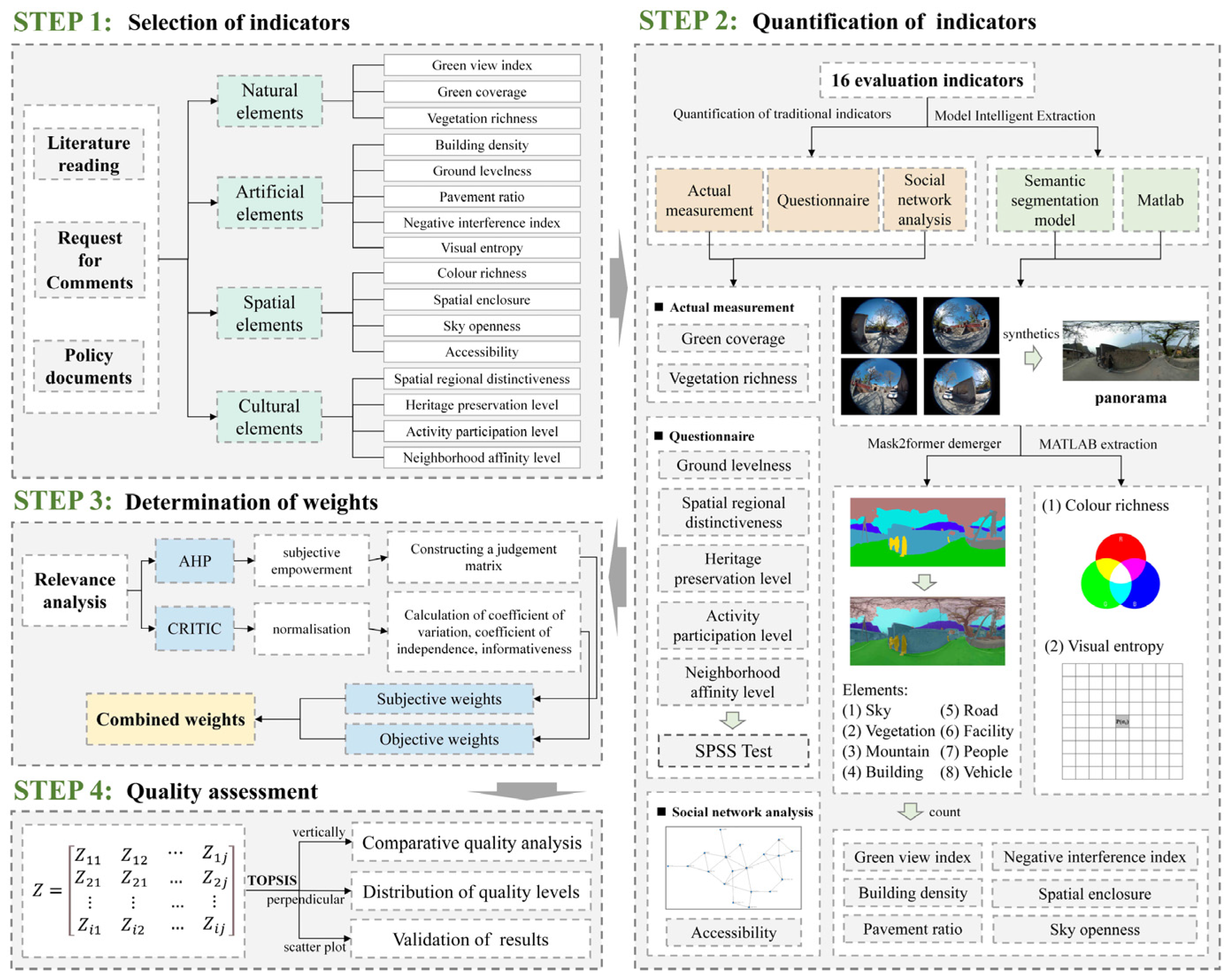
2. Materials and Methods
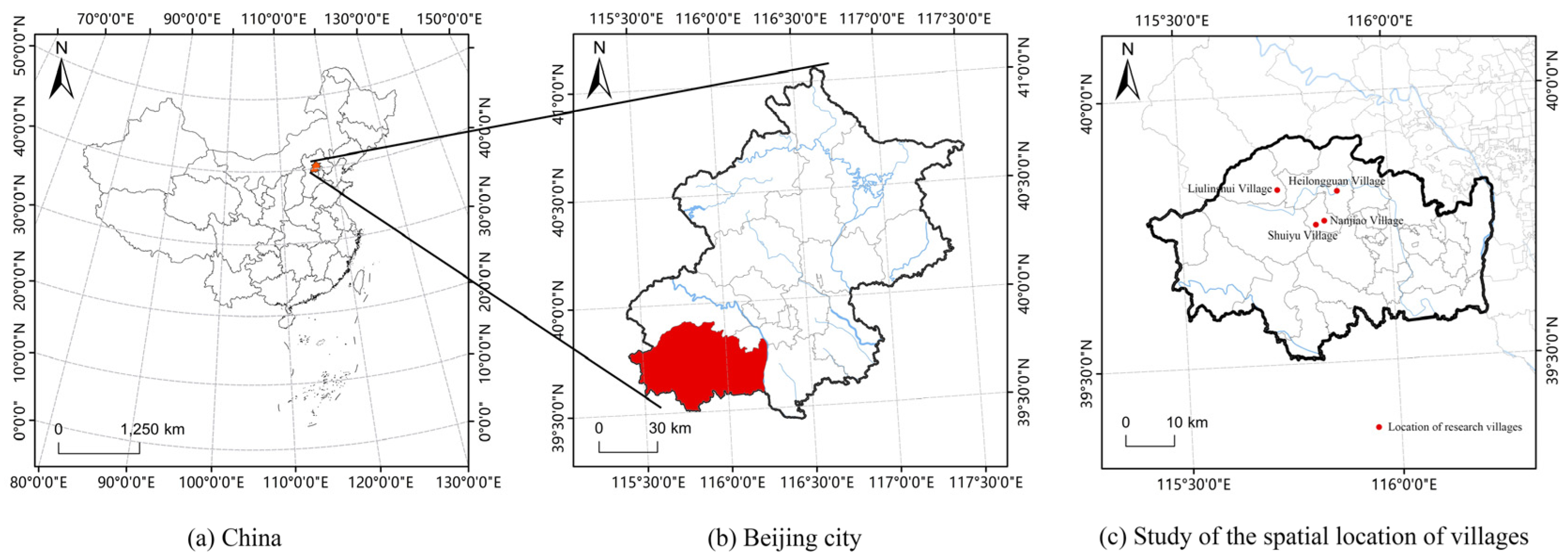
The research methodological framework includes four steps (Figure 1): (1) the selection of the evaluation indicators of the quality of public spaces in traditional villages by reviewing the literature and policy documents as well as consulting with experts; (2) the quantification of the evaluation indicators using the Mask2former image segmentation model, MATLAB R2024a software, actual measurement, questionnaire, and social network analysis; (3) the creation of a quality evaluation system for public spaces in traditional villages using the AHP and CRITIC methods to determine the combined weights of the evaluation indicators; and (4) the evaluation of public spaces in traditional villages using the TOPSIS method and the verification of the evaluation results using the linear fitting method.

2.1. Study Area

Located in the southwestern part of Beijing, Fangshan District has a total area of 2019 km2 and a resident population of 1,311,000. As the junction of the North China Plain and the Taihang Mountains, Fangshan District encompasses mountainous, hilly, plain, and depressional topography and landscapes. As of 2024, a total of five villages in Fangshan District have been listed as national-level traditional villages: Shuiyu Village (Nanjiao Township), Nanjiao Village (Nanjiao Township), Heilongguan Village (Fozizhuang Township), Liulinshui Village (Shijiaying Township), and Baoshui Village (Puhua Township), and owing to its rich natural resources and high historical and cultural value, Fangshan District has been awarded the 2024 Model Area for the Concentrated and Continuous Protection and Utilization of Traditional Villages. Baoshui Village in Puwa Township was severely damaged in the ‘23-7’ heavy rainstorm flooding; thus, it is not included in the study area. As one of the three major traditional villages in Beijing, Fangshan District is a microcosm of China’s traditional villages and provides a good sample for studying the quality of public spaces in traditional villages (Figure 2).

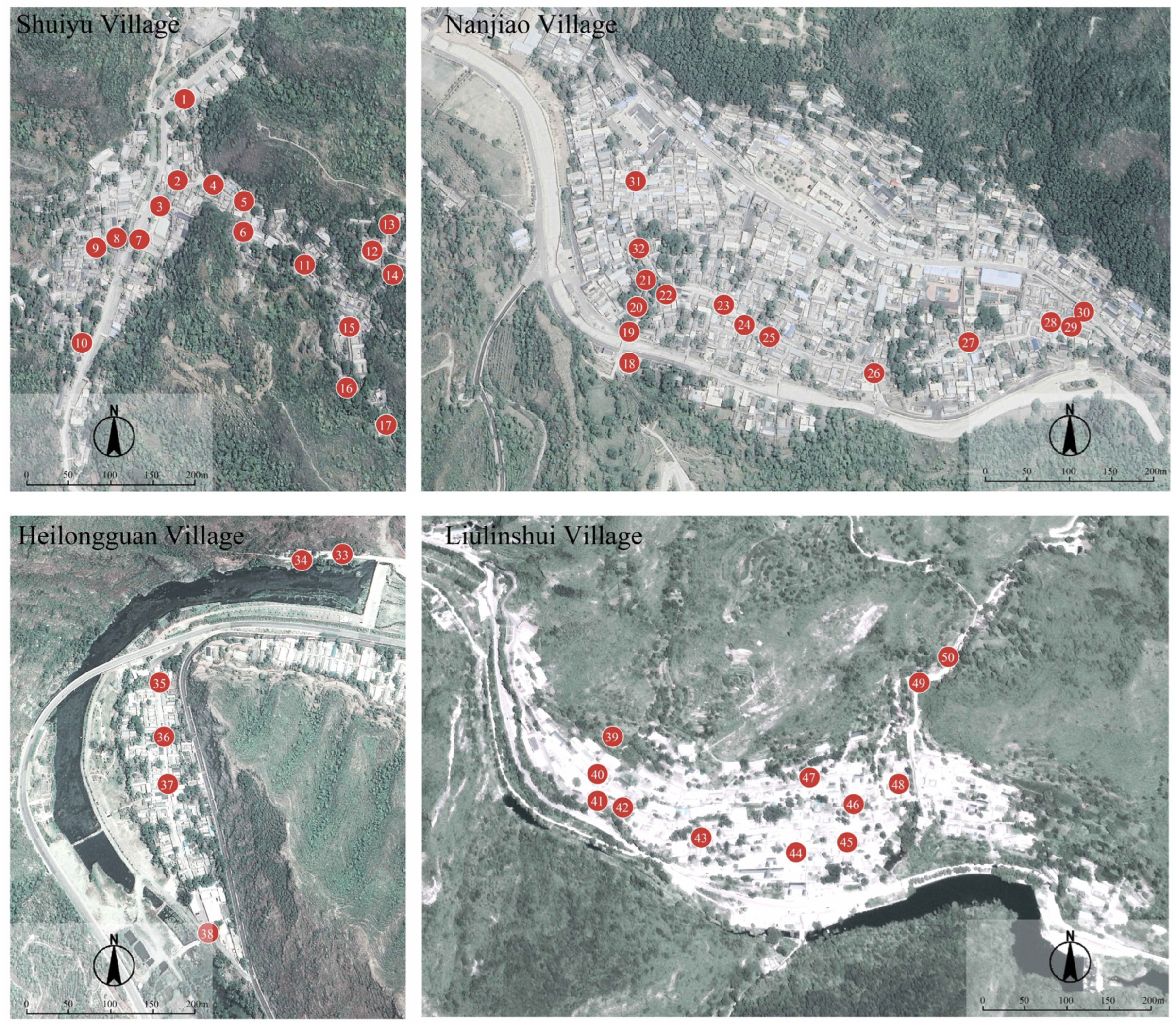
2.2. Selection of Public Spaces

Drawing on previous research results and policy documents from relevant Chinese authorities [50,51], the public spaces in traditional villages in this study are defined as public places where villagers can freely enter, carry out social activities, participate in public affairs, and exchange ideas in traditional villages with a relatively complete preservation of the overall pattern of the region and a strong sense of historical continuity. It does not include the natural landscape space on the periphery of the village. Through fieldwork, in-depth interviews, behavioral observation, and other methods of sample space selection for the four national-level traditional villages in Fangshan District, 50 typical public spaces with regional characteristics closely related to the villagers’ daily production and life were selected (Figure 3, Table 1). Since the public spaces in traditional villages primarily accommodate the living activities of villagers, they mainly consist of living public spaces. However, this does not affect the evaluation results, as this study assesses and grades the quality of these public spaces using spatial characteristic indicators, which are independent of the quantity of each space type.

2.3. Selection of Evaluation Indicators for the Quality of Public Spaces in Traditional Villages

Defining the types and characteristics of spatial elements is the basis for evaluating the quality of public spaces in traditional villages. With reference to the relevant research literature [15,52,53,54] and after consultation with experts in landscape architecture and related fields, this study classifies the element types of public spaces in traditional villages into four categories: natural, artificial, spatial, and cultural elements. Based on the types of elements in public spaces in traditional villages and the ‘Evaluation and Recognition Indicator System for Traditional Villages (Trial) [55]’, and drawing on eight traditional indicators, namely green coverage, vegetation richness, ground levelness, accessibility, spatial regional distinctiveness, heritage preservation level, activity participation level, and neighborhood affinity level [56,57,58,59,60], we selected eight objective spatial characteristic indicators for public spaces in traditional villages: green view index, building density, pavement ratio, negative interference index, visual entropy, color richness, spatial enclosure, and sky openness [24,39,61,62,63]. This forms a systematic construction of the evaluation indicator system for the quality of public spaces in traditional villages. The selected indicators should fulfil the following reference requirements: (1) they are in line with the research topic, (2) they can be scientifically and objectively quantified, and (3) they are widely and reliably applied. The meaning of the evaluation indicators and the method of quantification are presented in Table 2.

2.4. Quantification of Evaluation Indicators for the Quality of Public Spaces in Traditional Villages

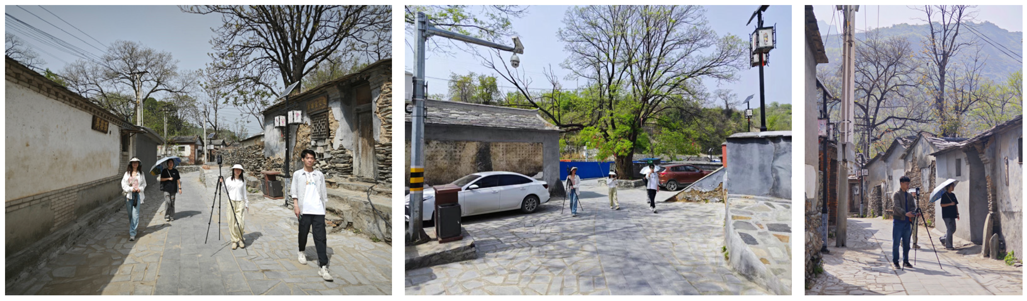
2.4.1. Panoramic Image Data Collection

The study was conducted using color panoramic photographs with a wide field of view that recorded environmental visual information within a 360° spatial range radiating from the viewpoint, which can be easily analyzed quantitatively by a computer. To ensure image quality and better match the visual range of the human eye, the height of the photographs was about 1.6 m, and the shooting time was 23–30 April 2024, from 8:00 to 11:00 and 14:00 to 16:00 in a clear window. Along the street space of Hailongguan, Shuiyu, Nanjiao, and Liulinshui villages, one photo was collected every 5 m (Figure 4); a total of 2012 photos were collected, and 503 panoramic photos were synthesized. After eliminating duplicated, low-definition, and mechanically failed images, a total of 450 images were used as the basic data for the next step of semantic segmentation.

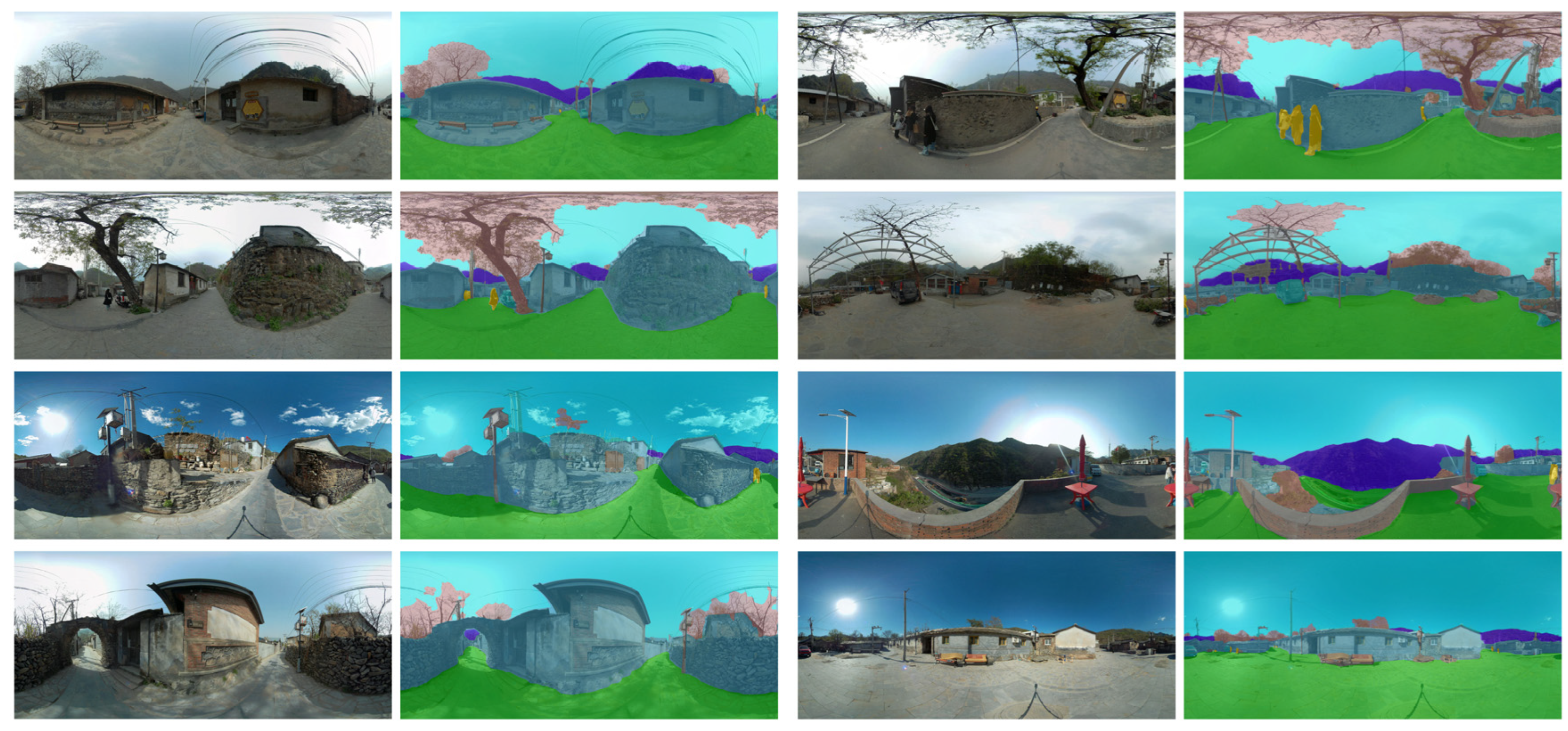
2.4.2. Deep Learning-Based Automatic Identification and Extraction of Elemental Features

In this study, a Mask2former image segmentation model based on the transformer backbone network was used (Figure 5). Mask2former is a powerful architecture that includes a backbone network, a pixel decoder, and a transformer decoder, which can perform tasks such as panoramic, instance, and semantic segmentations [64]. Compared with Deeplab V3+ and PSPNet, which are CNN-based models commonly employed for the semantic segmentation of urban street scenes, the Mask2former segmentation model has yielded good results on complex scene datasets, such as COCO and ADE20K, and its superiority has been confirmed in several image segmentation tasks [65]. In this study, the images of public spaces in traditional villages were divided into eight major elements: sky, vegetation, mountain, building, road, facility, people, and car. In view of the advantages of panoramic images in terms of omnidirectional display, a strong sense of reality, and large amount of information, a total of 400 panoramic images with comprehensive and clear spatial features were selected as the training set (80%) and test set (20%) of the Mask2former image segmentation model [66,67,68]. To ensure the reliability of the model training, each image was labelled by three researchers using the LabelMe5.3.1 software to label information about the training and test sets (Figure 6). After the labelling was completed, it was checked by three other researchers, and the inconsistency of the labelling results was proofread and discussed until consensus was reached. The trained model was used to output semantic segmentation images of 50 sample public spaces and count the proportion of each element in each image, which in turn calculates the green view index, building density, pavement ratio, negative interference index, spatial enclosure, and sky openness (Table 3).

2.4.3. MATLAB-Based Visual Entropy and Color Richness Calculation

Visual entropy is an important visual feature that affects the perception of a small-scale landscape. Based on MATLAB R2024a software, the visual entropy of an image was calculated after the steps of image recognition, grey scale enhancement, region division, and area calculation [69]. The principle is expressed in Equation (7). The color richness (C) was calculated using the image color richness calculation method proposed by Hasler et al. [70], and the principle is expressed in Equations (8)–(12).
H ( x ) = i = 1 n P ( a i ) × l o g P ( a i )
where n is the number of regions or cells with significant boundaries; i is the divided region; P ( a i ) is the probability of occurrence of region a i (i = 1, 2, …, n); and H ( x ) denotes the total amount of information generated for the entire visual object consisting of n regions.
r g = R G
y b = 1 2 ( R + G ) B
σ r g y b = σ r g 2 + σ y b 2
μ r g y b = μ r g 2 + μ y b 2
C = σ r g y b + 0.3 × μ r g y b
where R is red, G is green, and B is blue. r g is the difference between the red channel and the green channel. y b denotes half of the sum of the red and green channels minus the blue channel. σ r g y b and μ r g y b represent the standard deviation and the mean, respectively.

2.4.4. Quantification of Other Indicators

During the field research, green coverage (the ratio of the vertical projection area of green plants to the total area of public space) and vegetation richness (plant species) were measured on-site, and accessibility was quantified by the degree of centrality in the social network analysis (the number of connections between spatial nodes and other nodes). Furthermore, the Likert scale method was employed to set the ground levelness, spatial regional distinctiveness, heritage preservation level, activity participation level, and neighborhood affinity level to 5 levels (1 represents the worst, 5 represents the best), and a total of 719 valid questionnaires were obtained, with a validity rate of 95.87%. The reliability and validity of the questionnaire were examined using SPSS22.0 software, and the reliability coefficients of ground levelness, spatial regional distinctiveness, heritage preservation level, activity participation level, and neighborhood affinity level were 0.847, 0.833, 0.845, 0.877, and 0.849, respectively, with a KMO value of 0.844 and a p-value (sig.) < 0.05, which indicated that the reliability and validity were very good and the questionnaire data can accurately reflect the real level of traditional indicators.

2.5. AHP-CRITIC Method for Determining the Combined Weights of the Evaluation Indicators

2.5.1. AHP Method for Determining Subjective Weights

Landscape architecture experts, urban and rural planning specialists, officials responsible for the protection of traditional villages in Beijing, and resident villagers were each invited, with five individuals from each group, making a total of 20 participants. These participants subjectively assigned weights to the evaluation indicators and a judgement matrix was constructed. Subsequently, hierarchical ranking and consistency testing were performed. When the CR was less than 0.1, the judgement matrix met the consistency requirement; otherwise, adjustments had to be made. Finally, the subjective weights α j for each evaluation indicator were derived [71].
T j = k = 1 n X j k n
α j = T j j = 1 n T j
where T j is the square root vector; X j k is the scale value of the relative importance of the jth indicator to the kth indicator; and α j is the subjective weight of the jth indicator.

2.5.2. CRITIC Method for Determining Objective Weights

The CRITIC method is an objective weight assignment method based on indicator variability and correlation proposed by Diakoulaki et al. in 1995; it is significantly better than the entropy weight method [72]. As the standard deviation cannot measure the degree of variability of the indicators well, this study adopted the coefficient of variation CRITIC method to improve it according to the characteristics of the evaluation indicators for public spaces in traditional villages. First, the indicator data were normalized, and the coefficient of variation, independence coefficient, and information quantity of the indicators were calculated using Equations (15)–(18), respectively. Then, the ratio of the information quantity of a single indicator to the information quantity of all the indicators was used to determine the objective weights of the evaluation indicators.
V j = S j X j ¯ ( j = 1 , 2 , , n )
η j = k = 1 n ( 1 R k j ) ( j = 1 , 2 , , n )
C j = V j × j = 1 n ( 1 R k j ) ( j = 1 , 2 , , n )
β j = C j j = 1 n C j ( j = 1 , 2 , , n )
where V j is the coefficient of variation of the jth indicator; S j is the standard deviation of the jth indicator; X j ¯ is the mean value of the jth indicator; η j is the independence coefficient of the jth indicator; R k j is the Pearson correlation coefficient between the kth indicator and the jth indicator; C j is the amount of information covered by the jth indicator; and β j is the objective weight of the jth indicator.

2.5.3. Combined Weights of the Evaluation Indicators

After the subjective and objective weights were derived, the combined weights of the indicators were obtained as follows [73]:
ω j = α j × β j i = 1 n α j × β j
where ω j is the combined weight, α j is the subjective weight, and β j is the objective weight.

2.6. TOPSIS Method to Determine the Quality of Public Spaces in Traditional Villages

A weighted normalized evaluation matrix was constructed based on the combined weights of the evaluation indicators. The TOPSIS method was used to calculate the distance between each evaluated object and the ideal solution, and the closeness, E, indicates how closely each public space approaches the optimal solution, with a value closer to 1 signifying a better quality of public spaces in traditional villages [74]. Referring to the relevant research results, the standard deviation classification method was employed to categorize the public space of traditional villages into four distinct grades [75], as shown in Table 4.
(1) Construct the weighted normalization matrix Z:
Z i j = ω j × T i j
Z = [ Z 11 Z 12 Z 21 Z 21 Z 1 j Z 2 j Z i 1 Z i 2 Z i j ]
(2) Determine the positive and negative ideal solutions:
Z + = [ m a x ( Z i j ) ] = { Z 1 + , Z 2 + , , Z n + }
Z = [ m i n ( Z i j ) ] = { Z 1 , Z 2 , , Z n }
(3) Calculate the distance of each evaluation indicator from the positive and negative ideal solutions:
D i + = j = 1 n W j ( Z i j Z j + ) 2
D i = j = 1 n W i ( Z i j Z j ) 2
(4) Calculate the closeness of the evaluation object to the ideal solution:
E i = D i ( D i + + D i ) ( 0     E i     1 )
where T i j is the standardized value of the jth evaluation index of the ith evaluation object; Z + is the positive ideal solution; Z is the negative ideal solution; D i + is the Euclidean distance from the evaluation object to the positive ideal solution; D i is the Euclidean distance from the evaluation object to the negative ideal solution; and E i is the proximity of the evaluation object to the ideal solution.

3. Results

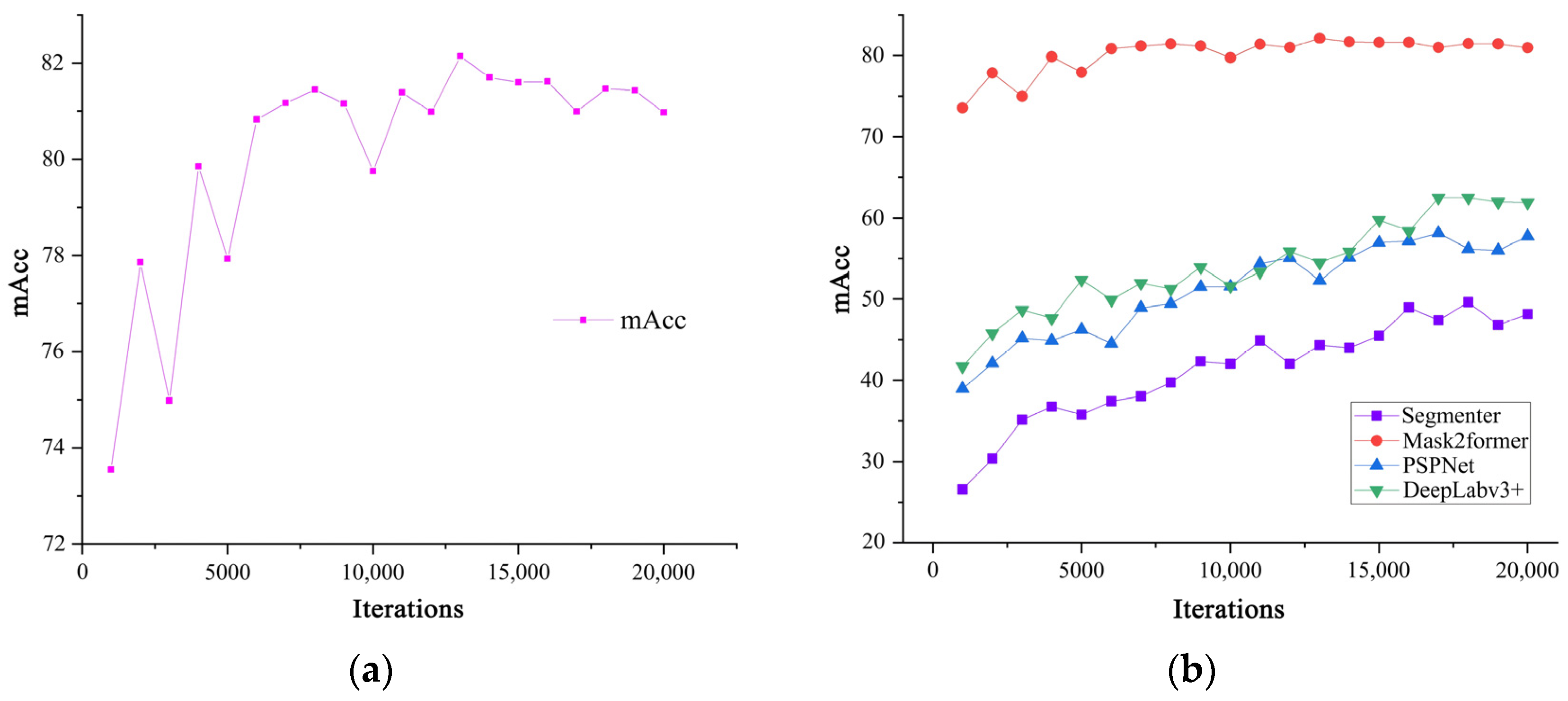
3.1. Performance of the Mask2former Image Segmentation Model

In this study, the Mask2former model was used for the semantic segmentation of panoramic images of public spaces in traditional villages. After 20,000 iterations, the accuracy reached 82.14%, achieving more satisfactory results than other common models (Segmenter, PSPNet, Deeplabv3+) (Figure 7). The element segmentation results exhibited minimal deviation from the ground truth, suggesting that the model is capable of accurately identifying the selected spatial elements in the panoramic images (Figure 8).

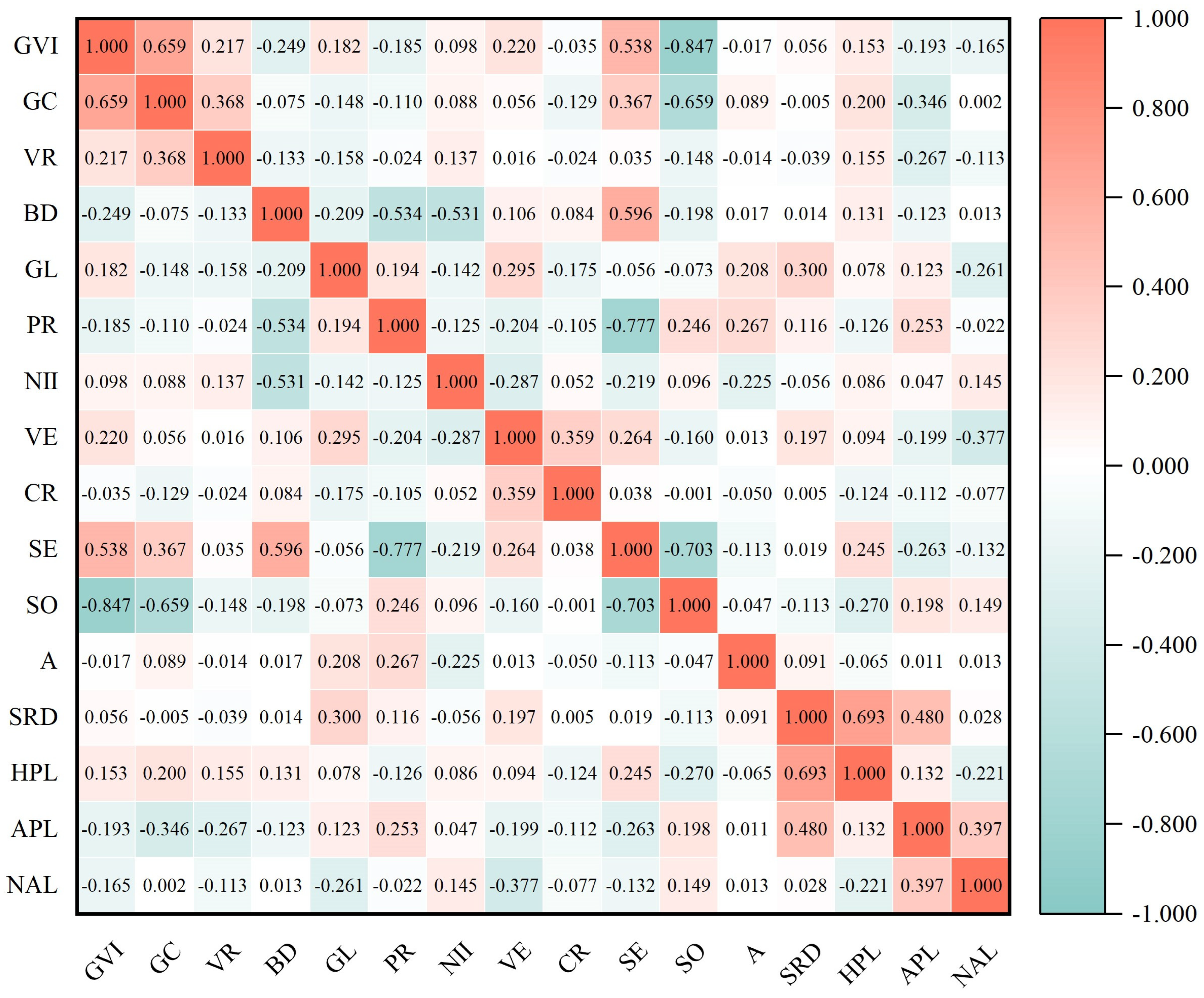
3.2. Correlation of Evaluation Indicators

The Pearson correlation coefficient (PCC) was used to test the multi-collinearity of the 16 indicators of the 50 public spaces, and a two-by-two comparison matrix of the evaluation indicators was constructed based on the correlation coefficients of the bilateral significance test (Figure 9). Furthermore, the correlation coefficients of the outputs were examined in accordance with the criterion of |r| ≥ 0.9 as a strong correlation [76]. The results indicate that the absolute value of the correlation coefficients of most of the indicators is low, suggesting that the 16 evaluation indicators are relatively independent from each other, which effectively reduces the multi-collinearity and makes the evaluation model more stable and reliable. From the PCCs of the 16 indicators, the green view index and green coverage were significantly positively correlated, with a correlation coefficient of 0.659. However, both were significantly negatively correlated with sky openness, with correlation coefficients of −0.847 and −0.659, respectively. In addition, the spatial enclosure showed negative correlations with the pavement ratio and sky openness, achieving correlation coefficients of −0.777 and −0.703, respectively. The correlations for the rest of the metrics were less pronounced, generally reaching below 0.5.

3.3. Weights of Evaluation Indicators

The AHP and CRITIC methods were employed to determine the combined weights of the evaluation indicators, thereby establishing the significance of each indicator in assessing the quality of public spaces in traditional villages (Table 5). In the element layer, the weights from highest to lowest were as follows: spatial elements (0.347), cultural elements (0.251), natural elements (0.218), and artificial elements (0.184). In the indicator layer, the weights in the top five were accessibility (0.132), color richness (0.099), green view index (0.095), activity participation level (0.085), and green coverage (0.069), suggesting that these five indicators were the key factors in the evaluation of the quality of public spaces in traditional villages and that they should be considered as a priority.

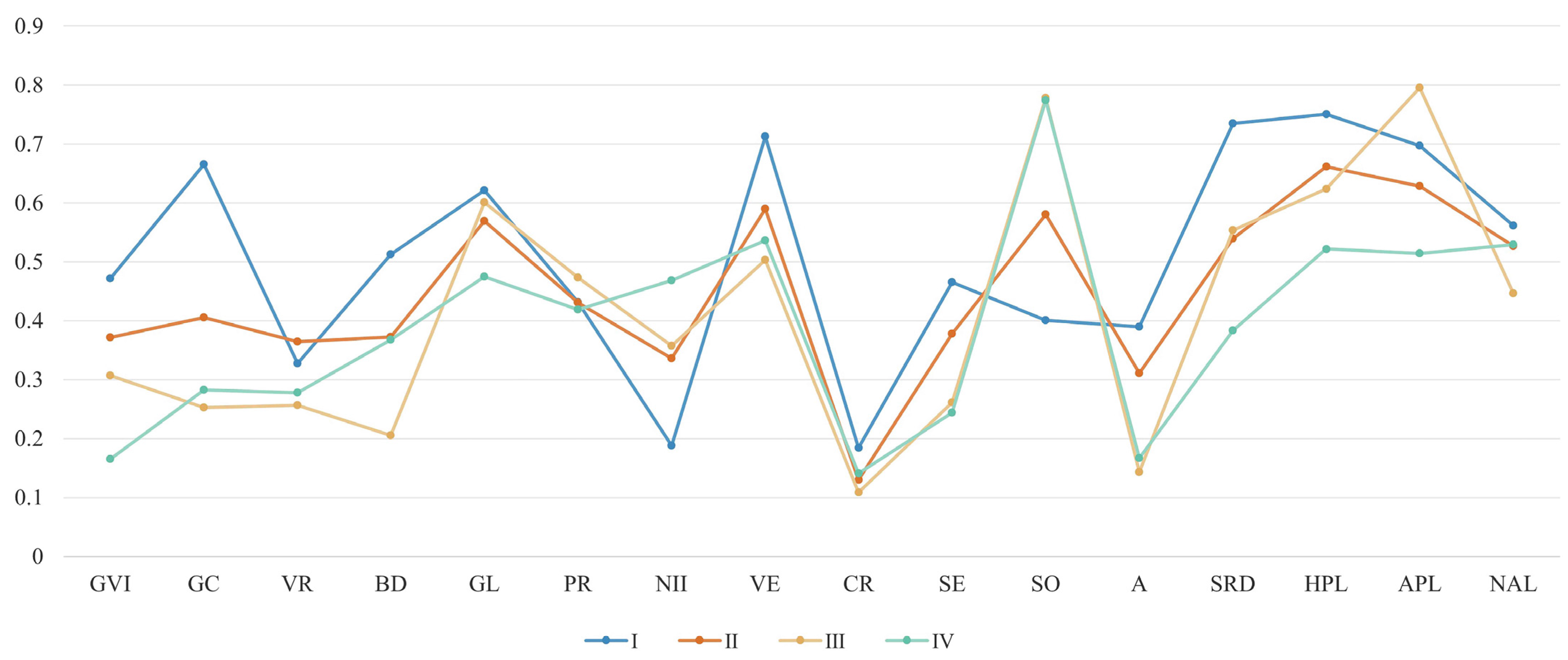
3.4. Evaluation Results of the Quality of Public Spaces in Traditional Villages

3.4.1. Comparative Analysis of the Quality of Public Spaces in Traditional Villages

After the weights of the evaluation indicators were determined, the TOPSIS method was employed to determine the quality level of the four traditional villages and the fifty sample public spaces (Figure 10). The four villages were ranked according to the quality levels of their public spaces as follows: Nanjiao Village (0.475), Shuiyu Village (0.432), Liulinshui Village (0.421), and Heilongguan Village (0.409). Among them, Nanjiao Village had a public space quality level of Grade I; Shuiyu Village and Liulinshui Village, Grade III; and Heilongguan Village, Grade IV. Among the 50 sample public spaces, the closeness values ranged from 0.327 to 0.581. The top five nodes were 19, 20, 4, 11, and 22, with closeness values of 0.581, 0.557, 0.536, 0.524, and 0.505, respectively. The bottom five nodes were 43, 34, 3, 40, and 10, with closeness values of 0.365, 0.364, 0.362, 0.349, and 0.327, respectively.

3.4.2. Spatial Distribution of the Quality Level of Public Spaces in Traditional Villages

Using the standard deviation classification method, the quality level of public spaces in traditional villages was divided into four distinct grades: Grade I (high), Grade II (higher), Grade III (medium), and Grade IV (low). A total of eleven Grade I, seventeen Grade II, four Grade III, and eighteen Grade IV public spaces were identified, accounting for 22%, 34%, 8%, and 36% of the total, respectively. This suggests that the imbalance in the quality level of public spaces in traditional villages in Fangshan District is prominent and that there is still much room for improvement in the overall quality. In terms of the distribution of the quality level of public spaces (Figure 11), Grade I public spaces are mainly concentrated in Nanjiao Village, whereas Grade II public spaces are mainly concentrated in Shuiyu Village and Liulinshui Village, mostly in the vicinity of street buildings, Niangniang temples, and ancient trees. However, half of the public spaces in Shuiyu Village and Liulinshui Village are still Grades III and IV, suggesting a more serious problem of imbalance compared to other villages. In addition, Heilongguan Village is smaller in scale, out of a total of six sample spaces selected, but four of them are Grade IV.

3.4.3. Characterization of Public Spaces in Traditional Villages

For the characteristics of the four types of public spaces (Figure 12), the green coverage and spatial regional distinctiveness of Grade I public spaces were significantly higher than those of the other three types of spaces, whereas the negative interference index was significantly lower, which is characterized by a high vegetation coverage rate, significant cultural characteristics, and less negative interference. The characteristics of Grade II and III public spaces were more similar, and they performed better in terms of heritage preservation level and activity participation level; however, the green view index and green coverage need to be improved. The Grade IV public spaces had a higher degree of sky openness and neighborhood affinity level, but the rest of the indicators were still at a lower level; in particular, the green view index and spatial regional distinctiveness were obviously low. Moreover, accessibility, color richness, and the green view index, which are the most important evaluation indicators affecting the quality of public spaces in traditional villages, were all at a low level in all four types of spaces. This is an outstanding problem, restricting the high-quality development of public spaces in traditional villages in Fangshan District, and needs to be focused on.

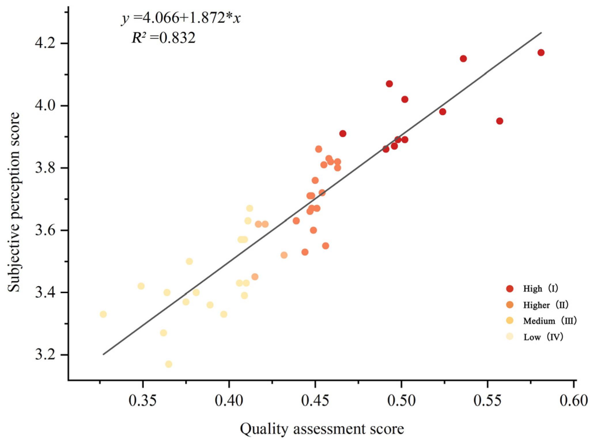
3.4.4. Validation of the Evaluation Results

To ensure the objectivity, scientificity, and reliability of the evaluation system, a total of 90 interviewees were invited to evaluate the subjective perception of 50 traditional village public spaces in this study, and the relationship between the quality level of public spaces in traditional villages and the subjective evaluation value is shown through a scatter plot. The interviewees included (1) 30 experts in the fields of landscape architecture, urban and rural planning, and environmental psychology; (2) 30 officials from local government departments; and (3) 30 villagers who were permanent residents or who had a desire to return to their hometowns. As shown in Figure 13, the evaluation results matched well with the public’s subjective perceptions, with an R2 value of 0.832, which was greater than 0.6, proving that the evaluation system constructed in this study basically predicted the actual level of the quality of public spaces in traditional villages. The actual level of quality of public spaces in traditional villages refers to the quality as perceived by the public.

4. Discussion

Under the influence of urbanization and tourism development, the lack of cultural connotations and a single function of public spaces in traditional villages are becoming more and more prominent, and the villagers’ sense of identity and belonging are not satisfied, which seriously hinders the sustainable development of traditional villages. However, most of the previous studies have focused on the spatial differentiation and spatial structure of traditional villages, with relatively little attention given to the public spaces at a micro-scale. Given that micro-scale public spaces in traditional villages are the smallest units for social interaction and physical well-being among villagers, they play a crucial role in enhancing rural social cohesion and villagers’ welfare; therefore, there is an urgent need for a comprehensive and objective assessment of its quality. This study has constructed a quality evaluation system for micro-scale public spaces in traditional villages and applied it to a representative area in China—Fangshan District, Beijing. The applicability and effectiveness of the evaluation system have been validated. This research provides both theoretical and practical insights for the protection and utilization of traditional village public spaces in China and similar countries.

4.1. Theoretical Contribution

By evaluating the quality of public spaces in traditional villages through deep learning and panoramic images, this study expands the interdisciplinary dialogue between AI and public space research at the micro-scale, addressing areas neglected in previous public space evaluation studies. This approach opens up new ways to enhance the protection of public spaces in traditional villages and stimulates the interest of scholars in geography and landscape in studying the evaluation of these public spaces. The case study in Fangshan District, Beijing, has validated that the evaluation system developed in this research can effectively evaluate the quality of public spaces in traditional villages, demonstrating its feasibility and convenience in the pre-study of these spaces, which can help designers eliminate the bias of subjective judgement as well as provide theoretical methods and analytical tools for the realization of the digital and refined planning and design of public spaces in traditional villages. In addition, this study provides a scientific, reliable, and cost-effective solution for the policy formulation and effect testing of the sustainable development of public spaces in traditional villages. Government departments can use this evaluation system to dynamically assess the effectiveness of public space construction in traditional villages and determine whether sustainable development in these spaces is being achieved. Based on the quality grades of public spaces, prominent issues, and work priorities, differentiated policy measures can be established.
Previous studies have mainly focused on humanized public spaces, arguing that the artificial elements of village settlements have a less significant influence on people’s positive emotions and preferences than natural and spatial elements [61,77]. In contrast, by focusing on the characteristics of the space itself, this study found that spatial elements have the greatest influence on the quality of public spaces in traditional villages, while artificial elements have the least influence (Figure 14a). This finding represents a new focus that current research has not yet fully explored and contributes to the enhancement of theoretical research in the field of rural landscape evaluation. Our study helps stakeholders better understand the interactions between the multiple elements of public spaces in traditional villages, prioritizing the most prominent problems that currently exist in such spaces, and develop long-term strategies for other goals [78].
This study found that accessibility, color richness, and the green view index had the highest degree of influence on the quality of public spaces in traditional villages (Figure 14b), consistent with the findings of Fang Qunli, Zhang Xinyu, and Yu Qiong [39,79,80]. In addition, the weight of accessibility was significantly greater than those of the other indicators, probably because accessibility, as an important feature of public space quality, is more likely to attract people to stay in public spaces that are easy to reach, which in turn meets people’s daily leisure needs [81]. Notably, previous studies have demonstrated that sky openness exerts a significant effect on the visual quality of public spaces in traditional villages as well as on the positive emotions of visitors [61,62]. However, the findings of this study are contrary to this, suggesting that sky openness has a lesser effect on the quality of public spaces in traditional villages. This may be due to the fact that the object of this study is the public spaces in traditional villages and that most of the selected typical public spaces are distributed along the main street, with less fluctuation in the level of sky openness, which, together with the interaction between many indicators, leads to a correspondingly smaller weight.

4.2. Practical Implications

Based on the evaluation results of the case area, we propose specific spatial planning and management strategies that are applicable to the Fangshan District of Beijing as well as other similar areas where the protection of traditional villages is in dire straits.
At the village scale, the study results indicate that the public spaces in traditional villages in Nanjiao Village have the highest quality, reaching Grade I, whereas those in Heilongguan Village have the lowest, at Grade IV. This is consistent with the actual situation, as Nanjiao Village has a clear conservation and development plan, with most of its traditional buildings and public spaces from the Ming and Qing Dynasties preserved, resulting in significant cultural characteristics. Meanwhile, Heilongguan Village has problems such as serious hollowing out, poor greening conditions, and insufficient cultural protection. Therefore, public space protection and utilization plans should be developed based on the village’s historical evolution and resource endowments. This involves delineating core protection zones and construction control zones, coordinating the preservation of heritage with development, ensuring the integrity and usability of traditional village public spaces, and meeting the growing material and cultural needs of the villagers.
At the node scale, Grade I and II public spaces are mainly concentrated in the vicinity of Niangniang Temple, street crossing buildings, and ancient trees. This is because spiritual and cultural public spaces mainly carry the nostalgic memories and good wishes of local villagers, and the government has set up strict protection measures. In addition, the villagers have a high sense of attachment and identity to this type of public space and will manage and maintain it spontaneously. This has effectively promoted the protection and utilization of the public spaces of traditional villages. Therefore, future efforts should focus on further establishing a multi-stakeholder protection and utilization mechanism based on ‘government leadership, community involvement, and social participation,’ to provide a solid foundation for the sustainable development of traditional villages. Grade III and IV public spaces are mostly located at road entrances, which is due to the fact that under the impact of rural tourism, in order to meet the needs of tourists for parking and catering, the form and structure of public spaces at intersections have drastically changed and modern materials and facilities, such as iron railings and signboards, have been filled in an unorganized manner. Therefore, while meeting the needs of users, traditional construction techniques should be inherited and developed, and more local materials should be used to protect the original landscape of the countryside.
Furthermore, the accessibility, color richness, and green view index of the four types of public spaces all need improvement. This can be achieved through the following measures: (1) improve the smoothness of streets and lanes, take important nodes in the village as the core, increase public space nodes according to the needs of villagers of different age groups, enhance the degree of connection between nodes, and form a functional and attractive public space network; (2) incorporate colors and materials that reflect local cultural characteristics, paint unique cultural symbols and signage on walls, and use colorful decorations such as lanterns and handcrafted items to enhance cultural flavor and visual depth; (3) utilize climbing plants to green the space façade, increase shrubs and herbaceous plants to form rich greening levels and three-dimensional landscapes, creating an ecological and livable public space.

4.3. Limitations and Suggestions for Future Research

We acknowledge that there are some limitations to the study and future research efforts should endeavour to address these. First, due to the fact that image data in rural areas are not easily accessible, the number of images of public spaces in traditional villages collected in this study are limited. In the future, other sources of images can be expanded, or local villagers can be encouraged to take photographs and participate in the data collection so as to explore the characteristics and the level of quality of public spaces in traditional villages on a wider scale. Second, although the evaluation system for public spaces in traditional villages constructed in this study is relatively comprehensive, the natural ecological conditions and socio-cultural connotations of traditional villages in different regions greatly vary, and the applicability and validity of the evaluation system may be problematic. Our future research will carry out case applications to evaluate the quality of public spaces in different types of traditional villages to test and validate the effectiveness of the evaluation system and to improve the evaluation system based on the results of the validation so as to construct a more stable, reliable, and universally applicable system for assessing the quality of public spaces in traditional villages.

5. Conclusions

In this study, using national-level traditional villages in Fangshan District, Beijing as a case study, we constructed a comprehensive evaluation system for the quality of public spaces in traditional villages. This system comprises sixteen indicators across four dimensions. We quantified these indicators using deep learning techniques, MATLAB, a questionnaire, actual measurements, and a social network analysis. To establish the weights of the indicators, we employed a combined approach of the AHP and CRITIC methods. Subsequently, we employed the TOPSIS method to evaluate the quality of public spaces in traditional villages and categorized them into four distinct grades. Finally, we validated the evaluation results using linear regression fitting. The main conclusions are as follows:
(1) In terms of indicator weights, the importance ranking of the elements is as follows: spatial, cultural, natural, and artificial elements. Among the indicators, the top five in terms of importance are accessibility, color richness, green view index, activity participation level, and green coverage. This will help stakeholders quickly solve the most prominent problems and deficiencies of public spaces in traditional villages.
(2) For the four selected traditional villages, the quality of public spaces in Nanjiao Village is Grade I; Shuiyu Village and Liulinshui Village, Grade III; and Heilongguan Village, Grade IV. Overall, there is large room for improvement in the quality of public spaces in traditional villages in Fangshan District. This provides data support for the optimal design of public spaces in traditional villages in Fangshan District, Beijing, and helps the local government formulate optimization strategies at a graded level to improve the quality of such spaces in the region.
(3) The validation results indicate that the evaluation scores of the quality of public spaces in traditional villages match well with the public’s subjective perceptions, with an R2 value of 0.832. Therefore, the evaluation system constructed in this study is feasible and accurate in predicting the quality of public spaces in traditional villages and can provide a scientific basis and technical tool for planning designers, policy makers, and village collectives in assessing the quality of public spaces in traditional villages in the region and optimizing the quality of these villages. Furthermore, it provides great support for achieving the sustainable development of traditional villages.

Author Contributions

Conceptualization, S.M.; methodology, S.M. and Y.Z. (Yunlu Zhang); software, S.M. and C.L.; validation, Y.Z. (Yuxi Zeng) and R.X.; formal analysis, S.M.; investigation, Y.Z. (Yuxi Zeng), R.X., C.Z. and Y.C.; data curation, S.M. and C.L.; writing—original draft preparation, S.M.; writing—review and editing, S.M.; visualization, K.W.; supervision, Y.Z. (Yunlu Zhang); funding acquisition, Y.Z. (Yunlu Zhang). All authors have read and agreed to the published version of the manuscript.

Funding

This research was funded by the General Project of Humanities and Social Sciences Research of the Ministry of Education of China (grant number: 23YJA760118), Key Project of the State Forestry and Grassland Administration of China (grant number: 2023132050) and Fundamental Research Funds of the Central Universities (grant number: PTYX202440).

Data Availability Statement

Data will be made available on request.

Acknowledgments

We would like to thank the editor and anonymous referees for their constructive suggestions and comments that helped to improve the quality of this paper.

Conflicts of Interest

The authors declare no conflicts of interest.

References

  1. Sardaro, R.; La Sala, P.; De Pascale, G.; Faccilongo, N. The conservation of cultural heritage in rural areas: Stakeholder preferences regarding historical rural buildings in Apulia, southern Italy. Land Use Policy 2021, 109, 105662. [Google Scholar] [CrossRef]
  2. Zhao, X.; Ju, S.; Wang, W.; Su, H.; Wang, L. Intergenerational and gender differences in satisfaction of farmers with rural public space: Insights from traditional village in Northwest China. Appl. Geogr. 2022, 146, 102770. [Google Scholar] [CrossRef]
  3. Guo, Z.; Sun, L. The planning, development and management of tourism: The case of Dangjia, an ancient village in China. Tour. Manag. 2016, 56, 52–62. [Google Scholar] [CrossRef]
  4. Katapidi, I. Heritage policy meets community praxis: Widening conservation approaches in the traditional villages of central Greece. J. Rural Stud. 2021, 81, 47–58. [Google Scholar] [CrossRef]
  5. Wang, D.; Zhu, Y.; Zhao, M.; Lv, Q. Multi-dimensional hollowing characteristics of traditional villages and its influence mechanism based on the micro-scale: A case study of Dongcun Village in Suzhou, China. Land Use Policy 2021, 101, 105146. [Google Scholar] [CrossRef]
  6. Liu, Y.; Li, Y. Revitalize the world’s countryside. Nature 2017, 548, 275–277. [Google Scholar] [CrossRef]
  7. Qi, W.; Deng, Y.; Fu, B. Rural attraction: The spatial pattern and driving factors of China’’s rural in-migration. J. Rural Stud. 2022, 93, 461–470. [Google Scholar] [CrossRef]
  8. Chen, X.; Xie, W.; Li, H. The spatial evolution process, characteristics and driving factors of traditional villages from the perspective of the cultural ecosystem: A case study of Chengkan Village. Habitat Int. 2020, 104, 102250. [Google Scholar] [CrossRef]
  9. Gao, J.; Wu, B. Revitalizing traditional villages through rural tourism: A case study of Yuanjia Village, Shaanxi Province, China. Tour. Manag. 2017, 63, 223–233. [Google Scholar] [CrossRef]
  10. Lekakis, S.; Dragouni, M. Heritage in the making: Rural heritage and its mnemeiosis at Naxos island, Greece. J. Rural Stud. 2020, 77, 84–92. [Google Scholar] [CrossRef]
  11. Elshof, H.; Haartsen, T.; Van Wissen, L.J.; Mulder, C.H. The influence of village attractiveness on flows of movers in a declining rural region. J. Rural Stud. 2017, 56, 39–52. [Google Scholar] [CrossRef]
  12. Fu, J.; Zhou, J.; Deng, Y. Heritage values of ancient vernacular residences in traditional villages in Western Hunan, China: Spatial patterns and influencing factors. Build. Environ. 2021, 188, 107473. [Google Scholar] [CrossRef]
  13. Sharifi, A.; Dawodu, A.; Cheshmehzangi, A. Limitations in assessment methodologies of neighborhood sustainability assessment tools: A literature review. Sustain. Cities Soc. J. SCS 2021, 67, 102739. [Google Scholar] [CrossRef]
  14. Wartmann, F.M.; Frick, J.; Kienast, F.; Hunziker, M. Factors influencing visual landscape quality perceived by the public. Results from a national survey. Landsc. Urban Plan. 2021, 208, 104024. [Google Scholar] [CrossRef]
  15. Šťastná, M.; Vaishar, A. Values of rural landscape: The case study Chlum u Třeboně (Bohemia). Land Use Policy 2020, 97, 104699. [Google Scholar] [CrossRef]
  16. Barrientos, F.; Martin, J.; De Luca, C.; Tondelli, S.; Gómez-García-Bermejo, J.; Casanova, E.Z. Computational methods and rural cultural & natural heritage: A review. J. Cult. Herit. 2021, 49, 250–259. [Google Scholar] [CrossRef]
  17. Chen, L.; Zhong, Q.; Li, Z. Analysis of spatial characteristics and influence mechanism of human settlement suitability in traditional villages based on multi-scale geographically weighted regression model: A case study of Hunan province. Ecol. Indic. 2023, 154, 110828. [Google Scholar] [CrossRef]
  18. Chen, W.; Yang, L.; Wu, J.; Wu, J.; Wang, G.; Bian, J.; Zeng, J.; Liu, Z. Spatio-temporal characteristics and influencing factors of traditional villages in the Yangtze River Basin: A Geodetector model. Herit. Sci. 2023, 11, 111. [Google Scholar] [CrossRef]
  19. Ma, H.; Tong, Y. Spatial differentiation of traditional villages using ArcGIS and GeoDa: A case study of Southwest China. Ecol. Inform. 2022, 68, 101416. [Google Scholar] [CrossRef]
  20. Xiang, H.; Xie, M.; Fang, Y. Study on the architecture space-social network characteristics based on social network analysis: A case study of Anshun Tunpu settlement. Ain Shams Eng. J. 2024, 15, 102333. [Google Scholar] [CrossRef]
  21. Yang, X.; Pu, F. Clustered and dispersed: Exploring the morphological evolution of traditional villages based on cellular automaton. Herit. Sci. 2022, 10, 133. [Google Scholar] [CrossRef]
  22. Wang, X.; Zhu, Q. Influencing factors of traditional village protection and development from the perspective of resilience theory. Land 2022, 11, 2314. [Google Scholar] [CrossRef]
  23. Chen, G.; Sun, X.; Yu, W.; Wang, H. Analysis Model of the Relationship between Public Spatial Forms in Traditional Villages and Scenic Beauty Preference Based on LiDAR Point Cloud Data. Land 2022, 11, 1133. [Google Scholar] [CrossRef]
  24. Chen, G.; Yan, J.; Wang, C.; Chen, S. Expanding the Associations between Landscape Characteristics and Aesthetic Sensory Perception for Traditional Village Public Space. Forests 2024, 15, 97. [Google Scholar] [CrossRef]
  25. Zhou, W.; Chen, L.-Y.; Chou, R.-J. Important factors affecting rural tourists’’ aesthetic experience: A case study of zoumatang village in Ningbo. Sustainability 2021, 13, 7594. [Google Scholar] [CrossRef]
  26. Lyu, Y.; Zhang, L.; Liu, X.; Ma, X. Microclimate-Adaptive Morphological Parametric Design of Streets and Alleys in Traditional Villages. Buildings 2024, 14, 152. [Google Scholar] [CrossRef]
  27. Xiong, Y.; Zhang, J.; Yan, Y.; Sun, S.; Xu, X.; Higueras, E. Effect of the spatial form of Jiangnan traditional villages on microclimate and human comfort. Sustain. Cities Soc. 2022, 87, 104136. [Google Scholar] [CrossRef]
  28. Zhang, L.; Miao, Y. An Experimental Eye-Movement Study on the Spatial Attraction Characteristics and Perception of Different Landscape Types in Ethnic Villages. J. Urban Plan. Dev. 2023, 149, 04023039. [Google Scholar] [CrossRef]
  29. Xie, C. Characteristics of public space behavior and demand of rural residents in foshan. In Proceedings of the E3S Web of Conferences, Hyderabad, India, 24–26 September 2021; p. 02011. [Google Scholar] [CrossRef]
  30. Qin, X.; Yang, D.; Wangari, V.W. Quantitative characterization and evaluation of highway greening landscape spatial quality based on deep learning. Environ. Impact Assess. Rev. 2024, 107, 107559. [Google Scholar] [CrossRef]
  31. Wang, R.; Zhao, J.; Liu, Z. Consensus in visual preferences: The effects of aesthetic quality and landscape types. Urban For. Urban Green. 2016, 20, 210–217. [Google Scholar] [CrossRef]
  32. Tang, J.; Long, Y. Measuring visual quality of street space and its temporal variation: Methodology and its application in the Hutong area in Beijing. Landsc. Urban Plan. 2019, 191, 103436. [Google Scholar] [CrossRef]
  33. de Val, G.d.l.F.; Atauri, J.A.; de Lucio, J.V. Relationship between landscape visual attributes and spatial pattern indices: A test study in Mediterranean-climate landscapes. Landsc. Urban Plan. 2006, 77, 393–407. [Google Scholar] [CrossRef]
  34. Zhang, M.; Li, Z.; Wu, X. Semantic segmentation method accelerated quantitative analysis of the spatial characteristics of traditional villages. Int. Arch. Photogramm. Remote Sens. Spat. Inf. Sci. 2021, 46, 933–939. [Google Scholar] [CrossRef]
  35. Kido, D.; Fukuda, T.; Yabuki, N. Assessing future landscapes using enhanced mixed reality with semantic segmentation by deep learning. Adv. Eng. Inform. 2021, 48, 101281. [Google Scholar] [CrossRef]
  36. Weichenthal, S.; Hatzopoulou, M.; Brauer, M. A picture tells a thousand… exposures: Opportunities and challenges of deep learning image analyses in exposure science and environmental epidemiology. Environ. Int. 2019, 122, 3–10. [Google Scholar] [CrossRef]
  37. Li, X.; Li, L.; Wang, X.; Lin, Q.; Wu, D.; Dong, Y.; Han, S. Visual quality evaluation model of an urban river landscape based on random forest. Ecol. Indic. 2021, 133, 108381. [Google Scholar] [CrossRef]
  38. Li, X.; Wang, X.; Jiang, X.; Han, J.; Wang, Z.; Wu, D.; Lin, Q.; Li, L.; Zhang, S.; Dong, Y. Prediction of riverside greenway landscape aesthetic quality of urban canalized rivers using environmental modeling. J. Clean. Prod. 2022, 367, 133066. [Google Scholar] [CrossRef]
  39. Zhang, X.; Xiong, X.; Chi, M.; Yang, S.; Liu, L. Research on visual quality assessment and landscape elements influence mechanism of rural greenways. Ecol. Indic. 2024, 160, 111844. [Google Scholar] [CrossRef]
  40. Li, X.; Zhang, X.; Jia, T. Humanization of nature: Testing the influences of urban park characteristics and psychological factors on collegers’’ perceived restoration. Urban For. Urban Green. 2023, 79, 127806. [Google Scholar] [CrossRef]
  41. Zhang, X.; Lin, E.S.; Tan, P.Y.; Qi, J.; Ho, R.; Sia, A.; Waykool, R.; Song, X.P.; Olszewska-Guizzo, A.; Meng, L. Beyond just green: Explaining and predicting restorative potential of urban landscapes using panorama-based metrics. Landsc. Urban Plan. 2024, 247, 105044. [Google Scholar] [CrossRef]
  42. Ki, D.; Lee, S. Analyzing the effects of Green View Index of neighborhood streets on walking time using Google Street View and deep learning. Landsc. Urban Plan. 2021, 205, 103920. [Google Scholar] [CrossRef]
  43. Wen, D.; Liu, M.; Yu, Z. Quantifying ecological landscape quality of urban street by open street view images: A case study of xiamen island, china. Remote Sens. 2022, 14, 3360. [Google Scholar] [CrossRef]
  44. Chen, B.; Feng, Q.; Niu, B.; Yan, F.; Gao, B.; Yang, J.; Gong, J.; Liu, J. Multi-modal fusion of satellite and street-view images for urban village classification based on a dual-branch deep neural network. Int. J. Appl. Earth Obs. Geoinf. 2022, 109, 102794. [Google Scholar] [CrossRef]
  45. Meng, C.; Song, Y.; Ji, J.; Jia, Z.; Zhou, Z.; Gao, P.; Liu, S. Automatic classification of rural building characteristics using deep learning methods on oblique photography. Build. Simul. 2022, 15, 1161–1174. [Google Scholar] [CrossRef]
  46. Wang, W.; Shi, Y.; Zhang, J.; Hu, L.; Li, S.; He, D.; Liu, F. Traditional village building extraction based on improved Mask R-CNN: A case study of Beijing, China. Remote Sens. 2023, 15, 2616. [Google Scholar] [CrossRef]
  47. Zu, X.; Gao, C.; Wang, Y. Interpreting regional characteristics of Tibetan-Qiang houses in Northwestern Sichuan by Deep Learning and Image Landscape. Int. J. Appl. Earth Obs. Geoinf. 2024, 129, 103865. [Google Scholar] [CrossRef]
  48. Fan, L.; Liu, Y.; Zhang, D. Spatial pattern of tourism development in traditional Chinese villages and its influencing factors. Econ. Geogr. 2023, 43, 203–214. [Google Scholar] [CrossRef]
  49. Han, H.; Guo, L.; Zhang, J.; Zhang, K.; Cui, N. Spatiotemporal analysis of the coordination of economic development, resource utilization, and environmental quality in the Beijing-Tianjin-Hebei urban agglomeration. Ecol. Indic. 2021, 127, 107724. [Google Scholar] [CrossRef]
  50. He, Y.; Wang, X.; He, Y.; Duan, Z.; Zeng, G. The revival and reconstruction of traditional rural public cultural space under the perspective of rural revitalization: A survey based on the ancestral halls in villages in Lianhua County, Jiangxi Province. J. Agric. For. Econ. Manag. 2019, 18, 822–828. [Google Scholar] [CrossRef]
  51. Wang, Y.; Meng, X.; Zou, Q. Graphical language and application of public open space in traditional villages. Chin. Gard. 2016, 32, 44–49. [Google Scholar]
  52. Arriaza, M.; Cañas-Ortega, J.F.; Cañas-Madueño, J.A.; Ruiz-Aviles, P. Assessing the visual quality of rural landscapes. Landsc. Urban Plan. 2004, 69, 115–125. [Google Scholar] [CrossRef]
  53. Carneiro, M.J.; Lima, J.; Silva, A. The relevance of landscape in the rural tourism experience: Identifying important elements of the rural landscape. J. Sustain. Tour. 2015, 23, 1217–1235. [Google Scholar] [CrossRef]
  54. Xie, H.; Zhu, Z.; He, Y.; Zeng, X.; Wen, Y. Integrated framework of rural landscape research: Based on the global perspective. Landsc. Ecol. 2022, 37, 1161–1184. [Google Scholar] [CrossRef]
  55. Evaluation and Recognition Indicator System for Traditional Villages (Trial). Available online: https://www.mohurd.gov.cn/gongkai/zhengce/zhengcefilelib/201208/20120831_211267.html (accessed on 1 June 2024).
  56. Aquilino, L.; Harris, J.; Wise, N. A sense of rurality: Events, placemaking and community participation in a small Welsh town. J. Rural Stud. 2021, 83, 138–145. [Google Scholar] [CrossRef]
  57. Bi, H.; Tang, H.; Guan, M.; Chen, H. The influencing mechanism and construction strategy of rural public space attachment: A case study of Qiu Village in Yingde. Chin. Gard. 2022, 38, 58–62. [Google Scholar] [CrossRef]
  58. Shen, L.; Zhang, Y.; Yao, M.; Lan, S. Combination weighting integrated with TOPSIS for landscape performance evaluation: A case study of microlandscape from rural areas in southeast China. Sustainability 2022, 14, 9794. [Google Scholar] [CrossRef]
  59. Sundblad, D.R.; Sapp, S.G. The persistence of neighboring as a determinant of community attachment: A community field perspective. Rural Sociol. 2011, 76, 511–534. [Google Scholar] [CrossRef]
  60. Zheng, J.; He, J.; Tang, H. The vitality of public space and the effects of environmental factors in Chinese suburban rural communities based on tourists and residents. Int. J. Environ. Res. Public Health 2022, 20, 263. [Google Scholar] [CrossRef]
  61. Chen, Z.; Yang, H.; Lin, Y.; Xie, J.; Xie, Y.; Ding, Z. Exploring the association between the built environment and positive sentiments of tourists in traditional villages in Fuzhou, China. Ecol. Inform. 2024, 80, 102465. [Google Scholar] [CrossRef]
  62. Lin, Y.; Yang, H.; Chen, Z.; Ding, Z. Analysis of landscape quality of traditional village cultural tourism space from the perspective of trail perception. J. Huaqiao Univ. 2024, 45, 370–382. [Google Scholar]
  63. Zhong, Y.; Zhang, M.; Xia, Y.; Hao, R.; Tan, L. Public Aesthetic and Recreational Preferences for Historical Irrigation Canals in Rural Areas: A Case Study in Li Canal-Gaoyou Irrigation District. Buildings 2024, 14, 1955. [Google Scholar] [CrossRef]
  64. Cheng, B.; Misra, I.; Schwing, A.G.; Kirillov, A.; Girdhar, R. Masked-attention mask transformer for universal image segmentation. In Proceedings of the IEEE/CVF Conference on Computer Vision and Pattern Recognition, New Orleans, LA, USA, 18–24 June 2022; pp. 1290–1299. [Google Scholar]
  65. Guo, S.; Yang, Q.; Xiang, S.; Wang, S.; Wang, X. Mask2Former with Improved Query for Semantic Segmentation in Remote-Sensing Images. Mathematics 2024, 12, 765. [Google Scholar] [CrossRef]
  66. Cao, Y.; Zhao, Z.; Huang, Y.; Lin, X.; Luo, S.; Xiang, B.; Yang, H. Case instance segmentation of small farmland based on Mask R-CNN of feature pyramid network with double attention mechanism in high resolution satellite images. Comput. Electron. Agric. 2023, 212, 108073. [Google Scholar] [CrossRef]
  67. Orhan, S.; Bastanlar, Y. Semantic segmentation of outdoor panoramic images. Signal Image Video Process. 2022, 16, 643–650. [Google Scholar] [CrossRef]
  68. Zheng, H.; Wang, M.; Wang, Z.; Huang, X. FireDM: A weakly-supervised approach for massive generation of multi-scale and multi-scene fire segmentation datasets. Knowl. Based Syst. 2024, 290, 111547. [Google Scholar] [CrossRef]
  69. Stamps, A.E., III. Entropy and visual diversity in the environment. J. Archit. Plan. Res. 2004, 21, 239–256. [Google Scholar]
  70. Hasler, D.; Suesstrunk, S.E. Measuring colorfulness in natural images. In Proceedings of the Human Vision and Electronic Imaging VIII, Santa Clara, CA, USA, 21–24 January 2003; pp. 87–95. [Google Scholar] [CrossRef]
  71. Zhao, P.; Ali, Z.M.; Ahmad, Y. Developing indicators for sustainable urban regeneration in historic urban areas: Delphi method and Analytic Hierarchy Process (AHP). Sustain. Cities Soc. 2023, 99, 104990. [Google Scholar] [CrossRef]
  72. Diakoulaki, D.; Mavrotas, G.; Papayannakis, L. Determining objective weights in multiple criteria problems: The critic method. Comput. Oper. Res. 1995, 22, 763–770. [Google Scholar] [CrossRef]
  73. Yang, T.; Zhang, Q.; Wan, X.; Li, X.; Wang, Y.; Wang, W. Comprehensive ecological risk assessment for semi-arid basin based on conceptual model of risk response and improved TOPSIS model-a case study of Wei River Basin, China. Sci. Total Environ. 2020, 719, 137502. [Google Scholar] [CrossRef]
  74. Dong, J.; Guo, R.; Guo, F.; Cai, J. Potential evaluation and implementation strategy for pocket park construction in high-density urban areas: A case study in dalian, China. Front. Archit. Res. 2024, 13, 319–334. [Google Scholar] [CrossRef]
  75. Li, Z.; Wang, L.; Gao, Y.; Li, J. Research on landscape emotion quantification based on scene EEG GRA-TOPSIS model: A case study of Xiangyang Weidong Factory. Landsc. Archit. 2022, 29, 33–40. [Google Scholar]
  76. Wu, Z.; Zhu, D.; Xiong, K.; Wang, X. Dynamics of landscape ecological quality based on benefit evaluation coupled with the rocky desertification control in South China Karst. Ecological Indicators 2022, 138, 108870. [Google Scholar] [CrossRef]
  77. Ren, X. Consensus in factors affecting landscape preference: A case study based on a cross-cultural comparison. J. Environ. Manag. 2019, 252, 109622. [Google Scholar] [CrossRef] [PubMed]
  78. Reyers, B.; Selomane, O. Social-ecological systems approaches: Revealing and navigating the complex trade-offs of sustainable development. In Ecosystem Services and Poverty Alleviation (Open Access); Routledge: London, UK, 2018; pp. 39–54. [Google Scholar]
  79. Fang, Q.; Zhu, Y. Research on optimization of public space in traditional Huizhou villages from the perspective of behavioral needs. Forecast 2021, 40, 90–96. [Google Scholar]
  80. Yu, J.; Egger, R. Color and engagement in touristic Instagram pictures: A machine learning approach. Ann. Tour. Res. 2021, 89, 103204. [Google Scholar] [CrossRef]
  81. Tomej, K.; Liburd, J.J. Sustainable accessibility in rural destinations: A public transport network approach. J. Sustain. Tour. 2020, 28, 222–239. [Google Scholar] [CrossRef]
Disclaimer/Publisher’s Note: The statements, opinions and data contained in all publications are solely those of the individual author (s) and contributor (s) and not of MDPI and/or the editor (s). MDPI and/or the editor (s) disclaim responsibility for any injury to people or property resulting from any ideas, methods, instructions or products referred to in the content.
Figure 1. Research framework.
Land 13 01584 g001
Figure 2. Study area.
Land 13 01584 g002
Figure 3. Public space samples.
Land 13 01584 g003
Figure 4. Panoramic image acquisition.
Land 13 01584 g004
Figure 5. Mask2former image segmentation model architecture.
Land 13 01584 g005
Figure 6. LabelMe5.3.1 software labelling interface.
Land 13 01584 g006
Figure 7. Image segmentation model accuracy. (a) Mask2former test accuracy; (b) Comparison of the accuracy of 4 model tests.
Land 13 01584 g007
Figure 8. Panoramic image semantic segmentation results.
Land 13 01584 g008
Figure 9. Matrix of evaluation indicator correlations.
Land 13 01584 g009
Figure 10. Quality comparison of 4 villages and 50 nodes.
Land 13 01584 g010
Figure 11. Distribution of the quality level of 50 nodes.
Land 13 01584 g011
Figure 12. Comparison of the characteristics of the four types of public space.
Land 13 01584 g012
Figure 13. Relationship between the quality evaluation score and subjective perception score.
Land 13 01584 g013
Figure 14. Comparative importance of the evaluation indicators. (a) Element layer; (b) indicator layer.
Land 13 01584 g014
Table 1. Basic properties of public space samples.
No.TypeArea (m2)No.TypeArea (m2)
1Living public space17326Living public space 83
2Living public space 6527Faith-based public space 46
3Living public space 3228Living public space 67
4Faith-based public space 8529Living public space 29
5Living public space 3530Living public space 302
6Living public space 24331Living public space 59
7Recreational public space76132Living public space 28
8Living public space 8833Living public space 528
9Faith-based public space 7334Faith-based public space 42
10Living public space 19735Living public space 71
11Living public space 34336Living public space 59
12Recreational public space11337Living public space 56
13Living public space 12538Living public space 188
14Living public space 9139Productive public space567
15Living public space 8340Recreational public space818
16Living public space 7141Living public space 51
17Productive public space11842Living public space168
18Recreational public space10043Living public space37
19Living public space 32144Living public space 96
20Faith-based public space 37145Recreational public space177
21Faith-based public space 18346Productive public space263
22Living public space18247Living public space 112
23Recreational public space38348Recreational public space1027
24Living public space13949Living public space272
25Productive public space6850Faith-based public space162
Table 2. Evaluation indicators for the quality of public spaces in traditional villages.
QualityElementsIndicatorsIndicator DescriptionQuantitative Method
Quality of public spaces in traditional villagesNatural elementsGreen view index
(GVI)
Proportion of green landscape pixels in the imageSemantic segmentation
Green coverage
(GC)
Ratio of green area to total areaActual measurement
Vegetation richness
(VR)
Types of plants in the spaceActual measurement
Artificial elementsBuilding density
(BD)
Proportion of architectural pixels in the imageSemantic segmentation
Ground levelness
(GL)
Levelness of the floor in the spaceQuestionnaire
Pavement ratio
(PR)
Proportion of road pixels in the imageSemantic segmentation
Negative interference index
(NII)
Proportion of pixels in the image that are cars, utility poles, etc.Semantic segmentation
Spatial elementsVisual entropy
(VE)
Entropy of the imageMATLAB
Color richness
(CR)
Color richness as perceived by the naked eyeMATLAB
Spatial enclosure
(SE)
Ratio of building pixels and plant pixels to pavement pixelsSemantic segmentation
Sky openness
(SO)
Proportion of sky pixels in the imageSemantic segmentation
Accessibility
(A)
Ease of access to the siteSocial network analysis
Cultural elementsSpatial regional distinctiveness
(SRD)
Level of territorial specificity of spaceQuestionnaire
Heritage preservation level
(HPL)
Level of preservation of historical sites in the spaceQuestionnaire
Activity participation level
(APL)
Level of participation in public eventsQuestionnaire
Neighborhood affinity level
(NAL)
Level of neighborhood affinityQuestionnaire
Table 3. Evaluation indicators for the quality of public spaces in traditional villages based on deep learning.
Evaluation IndicatorsVisual ElementsFormulaFormula Number
Green view index (GVI)Vegetation, mountain GVI = A v _ i + A m _ i A t _ i (1)
Building density (BD)Building BD   = A b _ i A t _ i (2)
Pavement ratio (PA)Road RWI   = A r _ i A t _ i (3)
Negative interference index (NII)Car, facility NII   = A c _ i + A f _ i A t _ i (4)
Spatial enclosure (SE)Vegetation, building, road SE   = A v _ i + A b _ i A r _ i (5)
Sky openness (SO)Sky SOI   = A s _ i A t _ i (6)
Where A t _ i is the total number of pixels in image i; A v _ i is the number of vegetation pixels in image i; A m _ i is the number of mountain pixels in image i; A b _ i is the number of building pixels in image i; A r _ i is the number of road pixels in image i; A c _ i is the number of car pixels in image i; A f _ i is the number of facility pixels in image i; A s _ i is the number of sky pixels in image i.
Table 4. Criteria for classifying the quality of public space in traditional villages.
Closeness (E) [ 0 ,   X ¯       0.5 σ ) [ X ¯       0.5 σ ,   X ¯ ) [ X ¯ ,   X ¯   +   0.5 σ ) [ X ¯     +   0.5 σ , 1)
Quality level of public spaces in traditional villagesLow
(IV)
Medium
(III)
Higher
(II)
High
(I)
where X ¯ denotes the total mean value of the quality (closeness) of the public space of traditional villages within the study area; σ denotes the standard deviation of the quality (closeness) of the public space of traditional villages.
Table 5. Weights of the evaluation indicators.
QualityElementsWeightsIndicatorsSubjective WeightsObjective WeightsCombined Weights
Quality of public spaces in traditional villages
A1
Natural elements
B1
0.218Green view index
C1
0.0760.0790.095
Green coverage
C2
0.0580.0750.069
Vegetation richness
C3
0.0490.0690.054
Artificial elements
B2
0.184Building density
C4
0.0380.0780.047
Ground levelness
C5
0.0580.0370.035
Pavement ratio
C6
0.0610.0550.054
Negative interference index
C7
0.0650.0460.048
Spatial elements
B3
0.347Visual entropy
C8
0.0430.0420.028
Color richness
C9
0.0650.0960.099
Spatial enclosure
C10
0.0450.0630.045
Sky openness
C11
0.0520.0520.043
Accessibility
C12
0.0980.0850.132
Cultural elements
B4
0.251Spatial regional distinctiveness
C13
0.0530.0660.056
Heritage preservation level
C14
0.0550.0630.055
Activity participation level
C15
0.1060.0500.085
Neighborhood affinity level
C16
0.0790.0440.056
Disclaimer/Publisher’s Note: The statements, opinions and data contained in all publications are solely those of the individual author(s) and contributor(s) and not of MDPI and/or the editor(s). MDPI and/or the editor(s) disclaim responsibility for any injury to people or property resulting from any ideas, methods, instructions or products referred to in the content.

