Abstract
The rapid pace of urbanization and global climate change necessitates a thorough assessment of urban ecological resilience to cultivate sustainable regional ecosystem development. Cities along the Yangtze River face an intensifying conflict between ecological preservation and socio-economic growth. Analyzing the ecological resilience of these urban centers is essential for achieving equilibrium in regional urban ecosystems. This study proposes a “system process space” attribute analysis framework, taking into account urban development processes, ecosystem structure, and resilience evolution stages. Utilizing data from 45 Yangtze River cities, we establish a “Driver, Pressure, State, Impact, and Response” (DPSIR) evaluation index system to evaluate changes in ecological resilience levels and evolution trends from 2011 to 2022. Our findings indicate that: (1) The ecological resilience index of Yangtze River cities increased from 0.177 to 0.307 between 2011 and 2022, progressing through three phases: ecological resilience construction, rapid development, and stable development. (2) At the city level, ecological resilience along the Yangtze River exhibits uneven development characteristics. Upstream cities display a significant “stepped” pattern, midstream cities exhibit a significant “Matthew effect”, and downstream cities present a pyramid-shaped pattern. While regional differences in ecological resilience persist, overall polarization is gradually decreasing, intercity connections are strengthening, and there is a growing focus on coordinated regional development. (3) The spatial distribution of ecological resilience in Yangtze River cities demonstrates both continuity and evolution, generally forming a “core-edge” clustered pattern. Based on these findings, we recommend enhancing inter-city cooperation and connectivity, addressing imbalances in urban ecological resilience, and promoting high-quality ecological resilience development along the Yangtze River through tailored development strategies for each city.
1. Introduction
In the context of global urbanization, cities have become powerful hubs attracting population growth. Projections indicate that by 2050, 66 percent of the world’s population will live in urban areas, illustrating a significant “polarizing effect” [1]. The China Statistical Yearbook reports that by the end of 2022, China’s urban population had reached 921 million, with the urbanization rate rising from 36.22 percent in 2000 to 65.22 percent in 2022. This expansion, fueled by factors such as population growth and industrial development, has intensified urban connection and resulted in significant spatial agglomeration effects [2]. As complex social ecosystems, cities face challenges from both external risks and internal structural changes [3]. These consist of acute emergencies such as natural disasters (earthquakes, floods), terrorist attacks, public health crises, and workplace accidents, as well as ongoing issues such as climate change. These persistent challenges highlight the shortcomings of traditional linear and static management approaches in addressing “black swan” or “gray rhino” events, placing significant strain on urban ecosystems [4]. The ecological environment plays a crucial role in human survival and development and is essential for cultivating high-quality urban growth. To enhance public safety and explore effective strategies for urban ecological adaptation and transformation, it is necessary to guide urban ecosystem development utilizing a resilience-based approach [5].
The concept of resilience has evolved to encompass two main perspectives: equilibrium and evolutionary. Engineering and ecological resilience fall under the equilibrium theory, which evaluates a system’s capacity to recover from disturbances [6,7]. In contrast, the evolutionary approach emphasizes structural adjustments, the disruption of steady states, and the enhancement of adaptive capabilities [8]. The conceptualization of resilience has shifted from a focus on equilibrium to an emphasis on evolutionary processes. This transformation highlights the significance of system interactions, elemental flows, and the capacity to handle external shocks, balance internal vulnerabilities, and achieve sustainable growth. It marks a significant transition from prioritizing stability and equilibrium to exploring adaptive development pathways [9]. From an evolutionary standpoint, Holling [10] proposes that the essence of evolutionary resilience is rooted in adaptive cycle theory. This theory outlines four stages of system development: exploitation, conservation, release, and reorganization. Each phase exhibits varying degrees of potential, coping ability, and capacity for reorganization and transformation, thereby influencing overall system resilience. The effect of the “adaptive cycle” has extended the application of resilience concepts from natural ecosystems to human-dominated environments [11]. As cities, which are central to human ecology and hubs of activity, increasingly incorporate resilience principles, this has set the stage for the development of resilient city theory.
An analysis of the development logic of urban ecological resilience is essential for enhancing urban resilience systems and cultivating sustainable urban development. Current research in this field can be categorized as follows: (1) Conceptualizing urban ecological resilience: In the face of challenges posed by globalization, urbanization, and ecological fragility, assessing urban ecological resilience has become a critical component of evaluating overall urban resilience. This concept primarily addresses the capacity of urban ecosystems to swiftly and effectively adjust and optimize their structural elements in response to acute shocks or chronic pressures. Accordingly, these systems maintain a dynamic balance between the urban environment and external factors, emphasizing the continuous development of adaptation, change, and learning capabilities [12,13]. (2) Evaluating urban ecological resilience: Several approaches have been employed: (a) Functionalism: This perspective evaluates resilience in terms of reducing external disturbances and addressing internal pressures [14]. For instance, LU [15] analyzes resource-dependent cities, arguing that resilience is crucial for managing risk shocks, overcoming transformation challenges, and achieving sustainable development. (b) Structural theory: This approach is rooted in the characteristics of resilience [16]. BAO, for instance, utilizes the “potential connection resilience” framework to study spatiotemporal patterns of landscape ecological risks in the Minjiang River Basin [17]. (c) Process theory: This method focuses on the sequential stages of resilience development [18]. Zhang, for instance, evaluates the dynamic evolution of resilience and evaluates the ecological resilience of urban agglomerations in the Pearl River Delta from pressure, state, and response perspectives [19]. (d) Spatial correlation network: This approach constructs networks based on physical social information [20], production–life–ecological [21] spatial characteristics. Huang [22] has developed an urban ecological resilience network analysis framework including overall structure, component quality, and network function. (3) Identifying factors influencing urban ecological resilience: The urban ecological resilience system is complex, necessitating a study of various factors and their relationships in urban development [23,24]. SHI evaluates the ecological resilience of the Beijing–Tianjin–Hebei urban agglomeration utilizing a multiple linear regression model to explore how physical, social, and economic variables impact ecological resilience [25]; whereas, Lee argues that population density and economic development negatively affect the ecological resilience of the urban agglomeration in the middle reaches of the Yangtze River, while government green investment has a positive spatial spillover effect [26]. (4) Exploring urban ecological resilience governance: Global climate change presents significant challenges to urban ecosystems, making the integration of climate adaptation planning into urban development crucial for future sustainability [27]. Simultaneously, environmental pollution and resource shortages resulting from human activities have increased governmental emphasis on collaborative stakeholder governance and tangible improvements in urban green spaces [28]. Research on urban ecological resilience primarily evaluates its evolutionary characteristics, theoretical frameworks, development status assessments, influencing factors, and governance strategies. It comprises various scales, including national, watershed, and urban levels. Methodologically, studies employ the Moran index, Dagum Gini coefficient, kernel density estimation, and Markov chain models to analyze regional differences in urban ecological resilience patterns [29]. Besides, the entropy weight method, indicator system method, and coupled coordination model are utilized to study the temporal evolution and spatial distribution of urban ecological resilience [30,31]. Geographic detectors, geographically weighted regression models (GWR), spatial Durbin models, and projection pursuit evaluation models (RAGA-PP) are applied to explore relationships and mechanisms in urban ecosystems [32,33,34,35].
Current UER research has produced significant findings relevant to this study. Nevertheless, several crucial issues remain unaddressed and require immediate attention: (1) The concept of UER lacks comprehensive multidimensional analysis, adequate supporting indicator systems, and sufficient localized innovation; (2) Existing studies on UER’s spatial characteristics are primarily limited to geographic proximity. The flow and interaction of UER system components across provinces extend beyond conventional geographic boundaries, highlighting the need to explore spatial relationships of ecological resilience that transcend physical location; (3) Most research relies on static and single-level resilience measurements, neglecting the connection between internal and external systems and spatial elements across different regions. In addition, studies focusing on cities along the Yangtze River are comparatively scarce in terms of research scale. In light of these gaps, this paper makes the following contributions: Firstly, it establishes a localized theoretical analysis framework based on the multidimensional characteristics of “process system space,” incorporating resilience theory, three-dimensional space theory, and adaptive cycle theory. This framework explains the UER process mechanism and evaluates effective practical approaches for UER governance, offering fresh perspectives on the sustainable development of urban ecological resilience. Secondly, the study applies the “Driver, Pressure, State, Impact, and Response” (DPSIR) model to analyze UER along the Yangtze River, utilizing the entropy method to calculate the UER index from 2011 to 2022. Thirdly, it employs the kernel density estimation method to appraise the dynamic evolution of UER along the Yangtze River, enhancing the practical application of the DPSIR framework and offering a reference for regional urban ecosystem collaborative governance. This research not only advances the theoretical understanding of ecological resilience but also offers policy recommendations for government departments managing ecological resilience.
The structure of the paper is organized as follows: Section 1 introduces the topic and reviews relevant literature. Section 2 establishes the theoretical framework. Section 3 outlines the methodology, including an overview of the study area, the development of the urban ecological resilience index system for the Yangtze River, data sources, and research methods. Section 4 presents the analysis of results, followed by a discussion in Section 5. Finally, Section 6 summarizes the main conclusions and findings of this study.
2. Theoretical Framework
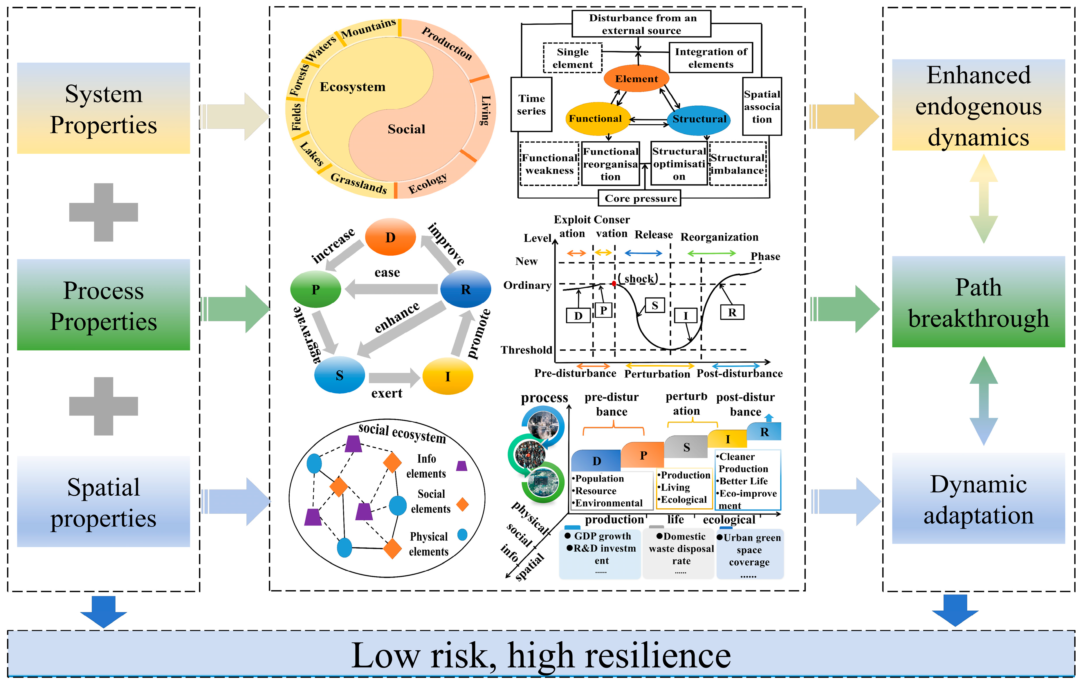
Since Holling introduced the concept of resilience to the social and ecological field, researchers have advanced theoretical frameworks for urban ecological resilience from various perspectives, including “urban scale, density and morphology” as well as “resistance adaptability resilience,” etc. [36,37]. UER represents a complex system comprising elements such as urban infrastructure and residents. This system exhibits dynamic and nonlinear characteristics in response to internal and external disturbances, facilitating the flow and exchange of information, materials, and energy both in the system and with the external environment through their interconnections [38,39]. Accordingly, the urban ecological resilience system exhibits characteristics related to system structure, processes, and spatial dimensions, as illustrated in Figure 1.
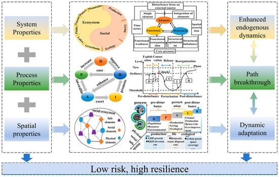
Figure 1.
Theoretical framework for UER.
When considering system characteristics, the objectives of UER span three dimensions: element integration, spatial structure reconstruction, and system function enhancement [40]. In factor integration, the approach addresses economic and resource disparities among cities, cultivating bidirectional factor flows between urban centers and optimizing resource allocation. As for structural reconstruction, efforts concentrate on optimizing and upgrading industrial structures, enhancing quality of life, and improving the connectivity of ecological landscapes. Regarding functional improvement, the UER system places emphasis on production, living, and ecological aspects to achieve a comprehensive enhancement of its capabilities. The interactions between the UER system and its external environment facilitate a continuous exchange of factors, energy, and information. This process, in conjunction with factor integration, spatial structure reconstruction, and system function enhancement, collectively advances the reshaping of urban production, living, and ecological spaces, thereby further strengthening the resilience of the urban ecosystem.
From a process-oriented perspective, this study categorizes the UER process into three phases: pre-disturbance, disturbance, and post-disturbance, aligning with the DPSIR [41]. In the development phase, urban ecosystems exhibit low risk and resilience levels. The preservation phase, reflected by rapid urbanization, contributes to a temporary surge in resilience but is accompanied by high risk due to excessive energy resource exploitation, impeding significant progress in adaptive development. The onset of a conflict between resource depletion and urban growth marks a period of decline, wherein the UER system enters a release phase. During this stage, cities face high risks and low resilience due to internal and external environmental pressures, such as climate change and ecological degradation. Finally, the restructuring phase achieves high-resilience development through element integration, reorganization, and functional optimization.
Regarding spatial characteristics, cities can be conceptualized as a “triadic space”, comprising physical, social, and informational components [42]. In this triadic spatial framework, UER is subject to spatial and temporal fluctuations. Spatially, cities in a region display variations in economic development, resource endowment, and other conditions. The advent of information technology has facilitated a high degree of convergence among the information space, physical world, and human society. This convergence transcends traditional geographical boundaries, resulting in interspatial geographic risk dissemination. Therefore, it is essential to construct a triadic spatial network and establish a resilience network that integrates these elements. To enhance urban resilience across these spatial dimensions, systematic governance, comprehensive policy implementation, and a dynamic adaptive approach are necessary.
3. Methods
3.1. Construction of the UER System
This paper utilizes established Urban Ecological Resilience (UER) indicators to construct a comprehensive five-dimensional framework [19,43]. The model integrates system, process, and spatial characteristics, utilizing the DPSIR approach as depicted in Table 1. Socioeconomic factors, including population influxes and extensive rapid urbanization, act as the primary drivers for UER (D). The convergence of these elements, coupled with accelerating industrialization and external shocks such as “gray rhinoceros” and “black swan” events, exerts pressure on urban ecological carrying capacity and resource utilization (P). Therefore, this leads to challenges such as resource depletion and environmental degradation. These drivers and pressures transform the UER system’s structure and function, influencing urban economic growth, air quality, and ecological civilization (S). The condition of the ecological resilience system affects urban production, living standards, ecology, and climate (I). In response to negative environmental effects, society implements various measures, including investments in pollution control, technological advancements, and environmental oversight. These actions generate positive feedback loops, resulting in enhanced resilience and improved system conditions (R). This feedback mechanism ensures the coordinated operation of the UER system.

Table 1.
Index system of UER along the Yangtze River.
3.2. Study Area
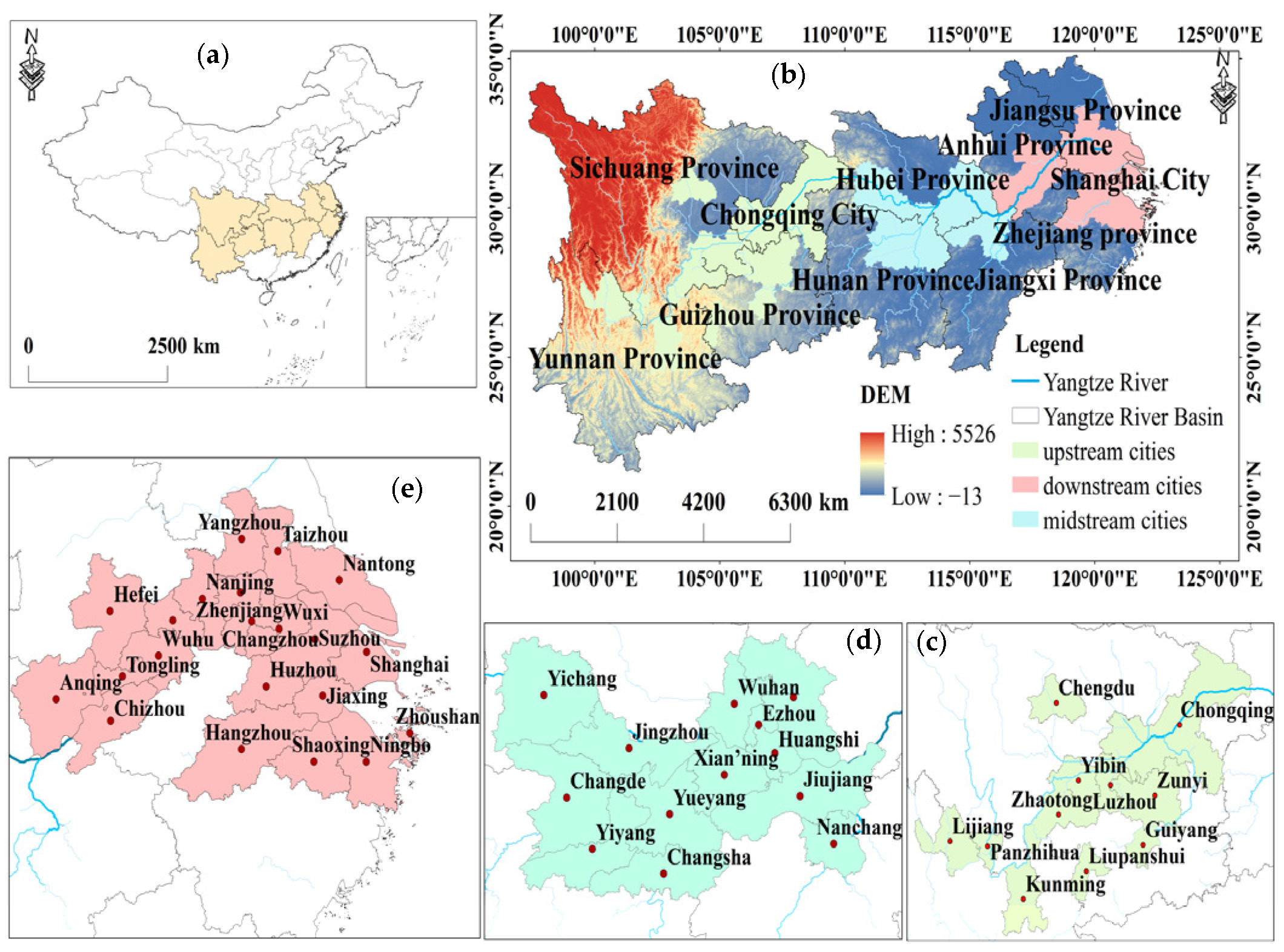
The Yangtze River Basin spans latitudes 24°30′ to 35°45′ N and longitudes 90°33′ to 122°25′ E. Its topography descends from west to east, including plateaus, mountains, basins, hills, and plains. The basin extends across nine provinces and two cities, including Shanghai, Jiangsu, Zhejiang, Anhui, Jiangxi, Hubei, Hunan, Chongqing, Sichuan, Yunnan, and Guizhou, covering eastern, central, and western China. Annual precipitation in the basin averages around 1000 mm, with irregular spatial and temporal distribution. Comprising approximately 21% of China’s land area, the basin housed approximately 43.01% of the national population by the end of 2022. It contributed 46.25% of China’s regional GDP and contained 40.23% of the nation’s water resources, indicating its significant economic power and resource wealth. In recent years, the intensification of global climate change, ongoing human activities, and growing resource demands have resulted in risks such as deteriorating ecological quality, high resource carrying capacity, and insufficient coordination between socioeconomic development and ecological conservation. These factors pose challenges to urban ecological governance and sustainable development.
This research focuses on 45 cities along the Yangtze River, excluding Enshi City due to missing data for several years. Linear interpolation to estimate these missing values would compromise the accuracy of results. The selected cities constitute the research sample for the period from 2011 to 2022. Following the classification scheme established by the Yangtze River Water Resources Commission, the river segment upstream of Yichang City in Hubei Province is designated as the “Upstream Yangtze Economic Belt.” The segment from Yichang City to Jiujiang City in Jiangxi Province is termed the “Midstream Yangtze Economic Belt.” The segment downstream of Jiujiang City in Jiangxi Province is referred to as the “Downstream Yangtze Economic Belt,” as depicted in Figure 2.

Figure 2.
Overview of the study area. (a) Geographic location of the Yangtze River Basin in China. (b) Location of the study area. (c) Upstream cities in the research area. (d) Midstream cities in the research area. (e) Downstream cities in the research area.
3.3. Data Sources
The social, economic and other data involved in this study were sourced from the following publications:
- (1)
- the China Urban Statistical Yearbook, 2011–2022 (https://navi.cnki.net/knavi/yearbooks/YZGCA/detail, accessed on 18 March 2024);
- (2)
- China Urban Construction Statistical Yearbook (https://navi.cnki.net/knavi/yearbooks/YCJTJ/detail, accessed on 18 March 2024);
- (3)
- China Environmental Statistics Yearbook (https://navi.cnki.net/knavi/yearbooks/YHJSD/detail, accessed on 18 March 2024);
- (4)
- National Economic and Social Development Bulletin of the municipalities
Missing data were completed by linear interpolation. Vector data in shp format for municipal administrative boundaries were obtained from the following publications:
- (1)
- the National Earth System Science Data Center (http://www.geodata.cn/, accessed on 20 March 2024);
- (2)
- Digital Elevation Model (DEM) data (30 m resolution) from Geospatial Data Cloud (https://www.gscloud.cn/, accessed on 20 March 2024);
- (3)
- NDVI from the Resource and Environmental Science Data Platform (https://www.resdc.cn, accessed on 20 March 2024).
3.4. Research Methods
3.4.1. Entropy Weight TOPSIS Method
This research utilizes the entropy weight TOPSIS approach to comprehensively evaluate Urban Ecological Resilience (UER) along the Yangtze River [44]. First, the entropy method normalizes the raw data and allocates weights to indicators based on data variability. The TOPSIS method then computes the distance between each city’s indicator values and both the optimal and worst-case scenarios to derive the ecological resilience composite index for previous years. The procedure involves the following steps:
- (1)
- Standardize positive, negative, and moderate indicators of the raw data utilizing the extreme variance method:
- (2)
- Entropy method for calculating indicator weights
- (3)
- Determine the positive and negative ideal solutions, and calculate the distance of each indicator from these ideal solutions:
- (4)
- Calculate the closeness of each metric in relation to the ideal solution:
3.4.2. Kernel Density Estimation
Kernel density estimation, a nonparametric statistical method, is utilized to approximate density functions. This approach facilitates explaining various distributional characteristics, including the centroid, pattern, and variability of a variable across time [45]. In this research, we utilize kernel density estimation to shed light on the temporal progression of Urban Ecological Resilience along the Yangtze River. Increased kernel density values signify a more robust UER. The mathematical expression for this calculation is as follows:
where represents the observation, denotes the mean of the observations, expresses the Gaussian kernel function, n depicts the number of sample observations, and h indicates the bandwidth.
4. Results
4.1. Temporal Evolution of UER
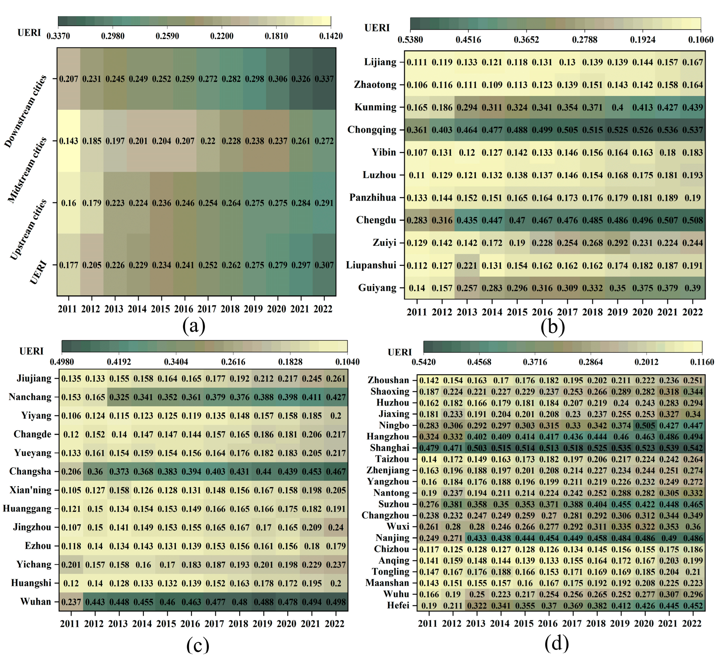
The comprehensive ecological resilience index for cities along the Yangtze River exhibited a significant increase from 0.177 in 2011 to 0.307 in 2022, with an average annual growth rate of 5.15%. This upward trend is depicted in Figure 3a. The period from 2011 to 2014 saw a gradual improvement in UER. During this time, China introduced the concept that “lucid waters and lush mountains are invaluable assets,” which required a period of adaptation in terms of industrial structure and ecological civilization. The years 2015 to 2018 marked a phase of sustained growth in UER development. Policies such as the “2016–2017 Action Plan for Ecological Environment Protection of the Yangtze River Economic Belt” and the “Outline of the Development Plan for the Yangtze River Economic Belt” prompted cities along the Yangtze River to place ecological environment construction at the forefront of their development strategies. The period from 2019 to 2022 witnessed rapid progress in ecological resilience, fueled by initiatives such as the “Yangtze River Delta Ecological Green Integrated Development Demonstration Zone” and the “Chengdu Chongqing Twin Cities Economic Circle ‘Six Rivers’ Ecological Corridor Construction Plan (2022–2035)”. These programs emphasized interregional and cross-basin collaboration, resulting in significant improvements in ecological protection and restoration. The quality of the ecological environment, including air quality and pollutant emissions, experienced significant enhancements, which cultivated the growth of green industries and urban agglomeration development. Throughout the study period, the average composite index value stood at 0.249, indicating significant room for further improvement and advancement of UER along the Yangtze River.
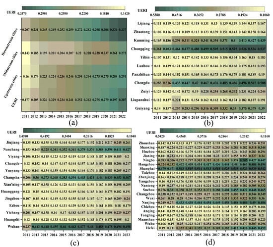
Figure 3.
UERI of cities along the Yangtze River (a), Upstream cities (b), Midstream cities (c), Downstream cities (d).
Regionally, ecological resilience index along the Yangtze River in upstream, midstream, and downstream cities aligns with the overall development trend. However, significant regional differences exist, as illustrated in Figure 3a. For upstream cities, the index rose from 0.160 in 2011 to 0.291 in 2022, deriving an average of 0.243 and an annual growth rate of 5.35%, which most closely approximates the UERI growth rate. Midstream cities, while exhibiting the lowest index, increased from 0.143 in 2011 to 0.272 in 2022, averaging 0.216. Specifically, these cities achieved the highest annual growth rate of 5.73% among all regions. Downstream cities maintained the highest index, climbing from 0.207 in 2011 to 0.337 in 2022. Their average surpasses that of both upstream and midstream regions, albeit with a lower annual growth rate of 4.35%.
In the cities situated along the upstream, midstream, and downstream sections of the Yangtze River, provincial capitals and municipalities under direct central government control typically have higher ecological resilience indices. UER exhibits an unbalanced developmental pattern overall. As presented in Figure 3b, the upstream region’s UER presents a clear tiered structure. Chongqing and Chengdu occupy the top tier with the highest ecological resilience index values, while Guiyang and Kunming form the second tier. The remaining cities display lower index values, though the differences among them are relatively minor. Specifically, Guiyang City experienced the most rapid growth, with its ecological resilience index soaring from 0.139 in 2011 to 0.389 in 2022, achieving an annual growth rate of 10.35%. In contrast, Zunyi’s ecological resilience index followed a “rising–declining–rising” pattern.
Zunyi’s impressive ecological resilience index can be attributed to its swift economic progress, which has led to significant advancements in ecological infrastructure, technological advancements, and environmental management. Nevertheless, Zunyi still suffers from obstacles, including the need to restructure its industrial sector and address soil and water conservation concerns, potentially hindering the qualitative enhancement of its ecological resilience. The “Matthew effect” is particularly evident in midstream cities, indicating an unbalanced “hourglass” configuration, as depicted in Figure 3c. Provincial capitals such as Wuhan, Changsha, and Nanchang—situated in Hubei, Hunan, and Jiangxi provinces—exhibit UERI values of 0.452, 0.393, and 0.340, respectively, exceeding the overall annual average UERI for the Yangtze River. In terms of average annual growth rate, Nanchang City stands out with the most rapid progress, its ecological resilience index rising from 0.153 in 2011 to 0.427 in 2022, reflecting an average annual growth rate of 9.35%. The UER in the downstream region exhibits a clear pyramid-shaped structure, as illustrated in Figure 3d. Shanghai, leveraging its advantageous location, leads as the “top performer” with an annual average ecological resilience index of 0.514. Other cities, including Hangzhou, Nanjing, Hefei, Suzhou, Ningbo, and Wuxi, also rank prominently in UERI and demonstrate comparatively swift growth rates.
4.2. Spatial Distribution of UER
To further analyze the spatial distribution patterns of cities along the Yangtze River, we classified the ecological resilience index into five categories, drawing from previous research: low (UERI < 2), lower (2 ≤ UERI < 4), medium (4 ≤ UERI < 6), higher (6 ≤ UERI < 8), and high (UERI ≥ 8). To capture the temporal shifts in UER, we selected average ecological resilience indices for three periods—2011–2014, 2015–2018, and 2019–2022—as well as the 12-year average. These were then visualized utilizing ArcGIS 10.2 software to illustrate their spatial distribution. It should be emphasized that throughout the entire study period, the ecological resilience index for each city consistently remained below 0.6. Accordingly, the ecological resilience along the Yangtze River was categorized into three levels: low, lower, and medium resilience, as illustrated in Figure 4.
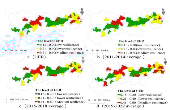
Figure 4.
Spatial distribution of UER along the Yangtze River (a), 2011–2014 average (b), 2015–2018 average (c), 2019–2022 average (d).
Figure 4 depicts the spatial distribution of UER along the Yangtze River, indicating both evolutionary continuity and significant spatial differences. The distribution exhibits a clustered pattern, with provincial capitals and municipalities in upstream, midstream, and downstream regions demonstrating higher UER values, while other cities exhibit lower figures. Specifically, downstream cities present significantly higher UER compared to their upstream and midstream counterparts. Regarding ecological resilience classifications, 22 cities along the Yangtze River are under the low UER category, constituting 48.89% of the total. This is followed by 17 cities in the lower UER bracket (37.78%), and six cities with medium UER (13.33%) (Figure 4a). The period from 2011 to 2014 saw 26 cities with low UER, with only Shanghai and Chongqing achieving medium UER status (Figure 4b). Between 2015 and 2018, overall UER improved, as the proportion of low UER cities decreased from 57.78% to 51.11%, while medium UER cities increased from 4.44% to 15.56%. Chengdu, Wuhan, Changsha, Nanjing, and Hangzhou joined the medium UER category (Figure 4c), resulting in a “dual city” configuration in the upstream region, featuring Chengdu and Chongqing.
From 2019 to 2022, the count of cities with low UER fell to 17, while those with medium UER rose to 12 (Figure 4d). Midstream cities demonstrate a “triad” configuration centered on provincial capitals, and downstream cities have moved beyond the low UER category, establishing an ecological resilience “highland.” These shifts in the distribution of ecologically resilient cities along the Yangtze River indicate an “inverted pyramid” spatial pattern, suggesting a progressive reduction in ecological resilience disparities among these urban areas.
4.3. Trends in UER
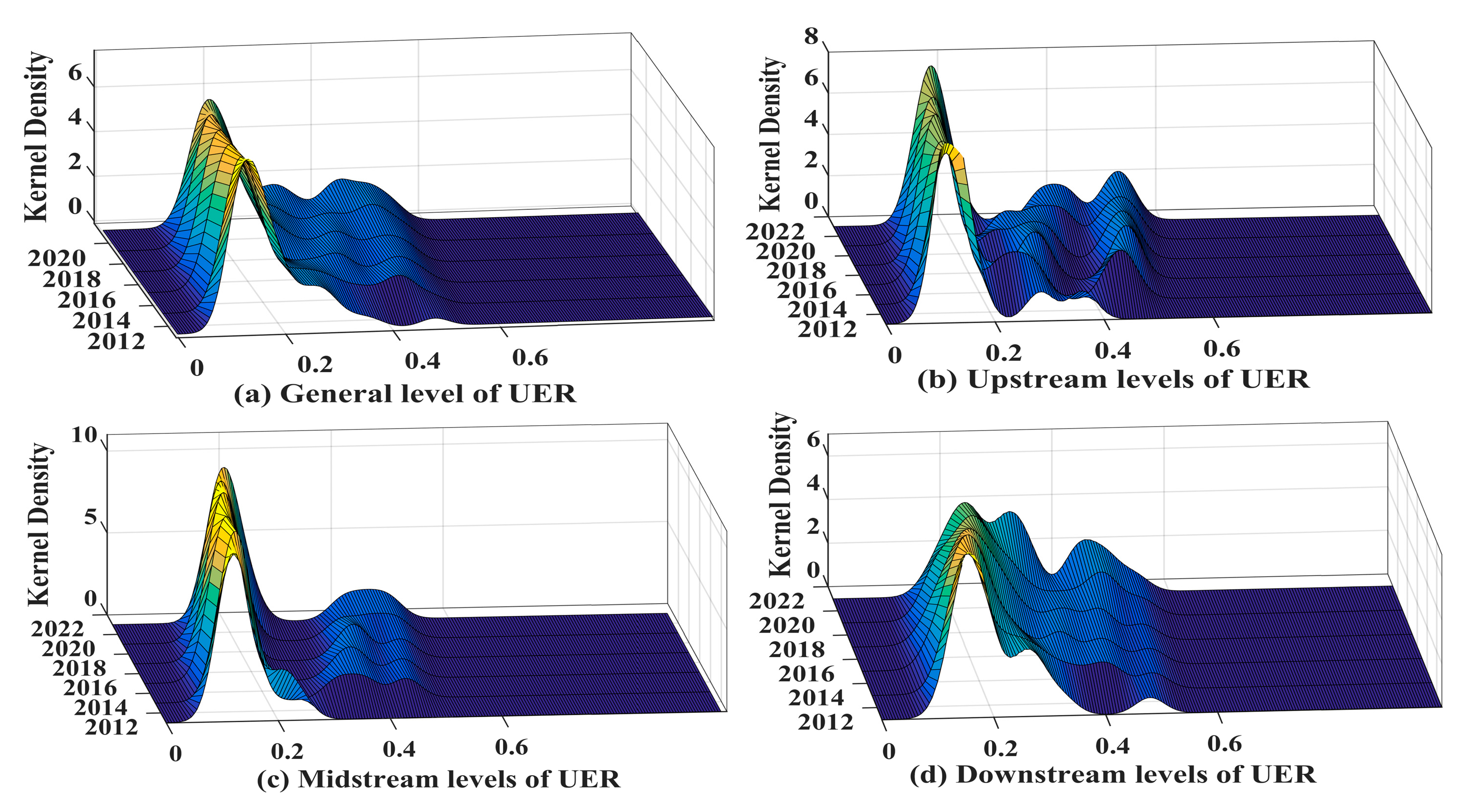
The kernel density curve’s location, distribution pattern, extent, and number of peaks illustrate the course and tendencies of UER variations along the Yangtze River as a whole, as well as in its upstream, midstream, and downstream cities. A general rightward movement in the density curves of cities along the Yangtze River (Figure 5a) reflects similar trends observed in upstream (Figure 5b), midstream (Figure 5c), and downstream cities (Figure 5d). This shift points to a steady enhancement in UER levels throughout the study period.
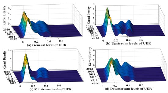
Figure 5.
UER core density curve (a), upstream cities (b), midstream cities (c) and downstream cities (d) along the Yangtze River.
The distribution pattern demonstrates that the main peak’s height in the UER along the Yangtze River, as well as in the upstream, midstream, and downstream cities, has increased to varying degrees, while their widths have contracted. This indicates a trend towards decreasing absolute differences in UER across these regions. The kernel density curve for downstream cities exhibits a “rising–declining–rising” pattern, reflecting a significant narrowing of the absolute UER differences in these urban areas.
The kernel density curves for upstream and midstream cities exhibit narrower and more significant peaks, indicating significant UER fluctuations in specific urban areas. The distribution of cities along the Yangtze River, including upstream, midstream, and downstream regions, displays varying degrees of rightward skewness. This pattern points to the existence of several high-value urban centers, such as Shanghai in the downstream area, Wuhan, Nanchang, and Changsha in the midstream region, and Chengdu in the upstream section. As time progresses, a noticeable convergence in UER distribution is evident for downstream cities, suggesting a decreased likelihood of extreme UER values. In contrast, the distribution for midstream and upstream cities has widened, implying an increase in the prevalence of cities with high UER. Regarding the number of peaks, cities along the Yangtze River exhibit a multi-peaked distribution, reflecting a gradual decrease in overall polarization and an enhancement of intercity connections. This trend highlights a growing focus on regional synergistic development. In contrast, the kernel density curve for cities in the middle reaches demonstrates two peaks: the secondary peaks are lower and more distant from the primary peak, indicating a clear trend towards polarization.
5. Discussion
5.1. Comparison of Previous Research
Prior research has established urban ecological resilience index systems drawing from theoretical frameworks such as “Production–Living–Ecology” [21], “Resistance–Adaptation–Vitality” [46], and “Pressure–State–Response” [35]. These analyses have primarily focused on national and watershed scales, employing diverse theoretical models, research parameters, and analytical approaches to assess urban ecological resilience indices [47,48]. While these studies have offered a thorough overview of urban ecological resilience, they have generally neglected to explore the fundamental mechanisms and dynamic interactions in urban ecological systems.
The evaluation of ecological resilience in cities along the Yangtze River indicates that those in the lower reaches exhibit comparatively high resilience levels, exhibiting strong resistance and adaptability to disaster risks, which aligns more closely with Zhang C.’s study [35]. Besides extreme risks such as flooding that push cities to enhance infrastructure, advance scientific and technological innovation, and human resources training, several other factors contribute to this resilience. These include a favorable geographic location, strict environmental regulations, high environmental consciousness among residents, an advanced industrial structure, robust scientific and technological progress, and a high level of economic growth [49]. In contrast, cities in the midstream of the Yangtze River have lower UER values, in line with Xiao S.’s findings [50]. Currently, midstream cities are undergoing a period of intense resource transformation. Coupled with rising urban populations and high resource consumption, these cities face significant ecological pressures that challenge the carrying capacity of their environments [26,34]. This observation supports the notion that increased “driving forces” escalate “pressure,” which subsequently affects the “state” of the environment and indirectly influences its outcomes. Urban clusters and regional integration policies can enhance urban ecological resilience at the “response” level. Moreover, identifying a coupling mechanism between urban development and the ecological environment is vital for enhancing regional ecological resilience. Earlier studies have demonstrated a complementary relationship between urbanization and ecological resilience [51,52]. However, a persistent conflict between economic growth and environmental preservation continues to be widespread in the region. This highlights the need for policymakers to explain the connection between urban ecosystems and socio-economic development when formulating policies. Encouragingly, policies such as the “Outline of the Development Plan for the Integration of the Yangtze River Delta Region”, the “Outline of the Construction Plan for the Chengdu Chongqing Dual City Economic Circle”, and the “Development Plan for the Chengdu Metropolitan Area” advocate leveraging the “dual core” effect to cultivate coordinated and balanced regional development. The creation of urban clusters, metropolitan areas, and regional integration mechanisms can significantly improve the overall capacity to manage risks and enhance the region’s ecological resilience.
5.2. Research Insights and Contributions
This paper establishes an analytical framework for UER according to resilience theory, ternary space theory, and adaptive cycle theory. In contrast to previous research that primarily concentrates on single-dimension analyses, this paper shifts the UER study from singular characteristics to a multidimensional perspective including “system process space”. It evaluates the spatial and temporal aspects of urban ecological resilience along the Yangtze River through this multidimensional approach. This methodology enriches UER evaluation, enhances the theoretical explanatory capacity of the aforementioned theories, and offers fresh perspectives and avenues for improving urban ecological resilience.
In addition, earlier studies typically frame UER in the “pressure state response” paradigm. However, considering the regional and developmental variations among specific cities, the selection of indicators must reflect these unique characteristics. This paper develops an urban ecological resilience index system utilizing the DPSIR model, taking into account both the multidimensional characteristics of UER and the specific developmental features along the Yangtze River. This system sheds light on the spatial and temporal distribution patterns of ecological resilience in cities along the Yangtze River and its evolutionary trends.
Addressing both regional development and intracity variations, this paper puts forward strategies to strengthen the ecological resilience of cities along the Yangtze River from both macro and micro perspectives. These recommendations aim to broaden the approaches for high-quality regional UER development.
On a broader scale, cultivating superior ecological progress in urban areas along the Yangtze River hinges on establishing an innovative framework for harmonized regional growth. This approach should be anchored in the principles of “ecological priority and green development”, with the connectivity of infrastructure representing a fundamental prerequisite. Advancements in science and technology should spearhead this effort, complemented by the optimization of industrial structures and rational spatial layout. Synergistic ecological management plays a critical role, while enhanced management systems offer essential backing. This strategy may cultivate a regional ecological network that promotes comprehensive green and high-caliber development across the urban centers lining the Yangtze River [53].
At the microscopic level, three critical strategies should be employed. First, the emphasis should be placed on synergy and linkage. Urban centers must prioritize integration and high-caliber development by facilitating the flow of resources and information in regional collaborative efforts, thus addressing the issue of “one city dominating”. City clusters can enhance the construction of safe and efficient integrated transport networks through technologies such as the Internet of Things and big data, thereby improving overall transport efficiency [19]. Secondly, innovation and sharing should take center stage. It is crucial to establish an innovation community that transcends administrative boundaries. This involves optimizing the allocation of innovation resources, ensuring their dissemination, and cultivating the integrated development of the ecological supply chain, industrial chain, innovation chain, and value chain. Such efforts will protect ecological security and drive the optimization and advancement of industrial structures [30]. Finally, planning and balance are indispensable. The concept of “resilience building” should be woven into urban development planning. This comprises improving social security systems in areas such as healthcare, education, and employment, tailored to the unique resilience histories of each city. In addition, developing specialized industries and rationalizing the distribution of functional zones in urban management will contribute to reducing regional differences.
6. Conclusions and Outlook
6.1. Conclusions
This paper proposes a resilience analysis framework incorporating process, system, and spatial characteristics. It utilizes 30 indicators across five dimensions (DPSIR) and applies the entropy weight TOPSIS model to assess UER of 45 cities along the Yangtze River. The research yields several key findings:
- (1)
- The UER along the Yangtze River exhibits a three-stage progression: initial gradual improvement, sustained development, and rapid growth. While UER has advanced, significant room for enhancement and further development remains.
- (2)
- Although the UER trend is consistent across upstream, midstream, and downstream cities of the Yangtze River, significant spatial differences exist, represented by cluster distribution patterns. The downstream region demonstrates the highest UER. City-level analysis indicates that provincial capitals and municipalities along the Yangtze River exhibit superior UER, yet overall development remains uneven. Midstream cities display a more significant “Matthew effect” in UER, indicating insufficient momentum for coordinated UER development.
- (3)
- Kernel density estimation results suggest a gradual reduction in the absolute UER gap along the Yangtze River. This trend points to a decreasing city polarization and strengthening intercity connections, reflecting an increasing focus on regional synergistic development.
6.2. Future Outlook and Deficiencies
This study has derived significant advancements; however, it faces certain constraints that future research must address. First, while the article presents an innovative theoretical framework combining complex social networks and resilience theory—offering a fresh perspective on regional urban ecological resilience—it does not fully incorporate previously established dimensions such as infrastructure, organizational, and economic resilience. Additionally, the heterogeneity in natural conditions and social resource endowments among cities highlights the necessity for a more universally applicable evaluation index system for urban ecological resilience.
Second, while the study evaluates regional differences in urban ecological resilience, it fails to evaluate the underlying causal mechanisms. This oversight restricts the accurate implementation of resilience strategies for both the entire region and individual urban areas. Future research should explore these causal mechanisms to optimize the theoretical framework and enhance its practical utility.
Third, the selection of research methodologies can influence results, and obtaining accurate indicator data for urban ecological resilience remains challenging. The absence of both subjective evaluations and objective data may introduce biases in resilience assessments. Therefore, establishing evaluation criteria and databases from multiple sources, based on land use changes and ecological landscapes resulting from urban expansion, could enhance the accuracy of urban ecological resilience assessments.
Author Contributions
All authors participated in the discussion, conceptualization, writing, revision, and improvement of the paper. C.L. (Chong Li) was responsible for constructing the analytical framework and writing the first draft; Y.W. provided strict guidance and revisions; W.Q. and C.L. (Cuixi Li) handled the visualization of graphs and data analysis; Y.Y. contributed to data searching. All authors have read and agreed to the published version of the manuscript.
Funding
This research was funded by a grant from the China University of Mining and Technology Graduate Student Innovation Programme Project (2024WLKXJ131) to Chong Li.
Data Availability Statement
The original contributions presented in the study are included in the article, further inquiries can be directed to the corresponding author.
Conflicts of Interest
The authors declare no conflicts of interest.
Abbreviations
DPSIR: Driver, Pressure, State, Impact, and Response; UER: Urban Ecological Resilience; UERI: Urban Ecological Resilience Index. Figurative Terms; Black swan: sudden and drastic impact of extreme weather and climate events on urban ecosystems, such as natural disasters, urban waterlogging, earthquakes, public health incidents, and safety production accidents; Gray rhinoceros: gradual, chronic, and long-term impacts of changes in climate factors on urban ecosystems, such as rising average temperatures and sea levels; Matthew effect: state of high-value agglomeration and low-value agglomeration in the level of urban ecological resilience. Such effect in cities and regions with high levels of ecological resilience will become increasingly high, while those with low levels of ecological resilience will become lower; Pyramid-shaped: a balanced development state of urban ecological resilience. There are few cities with high levels of ecological resilience, and many cities with higher levels, or with average levels; Ladder-shaped: a hierarchical distribution structure in which the level of urban ecological resilience shows a gradual increase or decrease.
References
- Zhong, S.; Wang, M.; Zhu, Y.; Chen, Z.; Huang, X. Urban expansion and the urban-rural income gap: Empirical evidence from China. Cities 2022, 129, 103831. [Google Scholar] [CrossRef]
- Zhang, Q.; Yao, Y.; Wang, Y.; Wang, S.; Wang, J.; Yang, J.; Wang, J.; Li, Y.; Shang, J.; Li, W. Characteristics of drought in Southern China under climatic warming, the risk, and countermeasures for prevention and control. Theor. Appl. Climatol. 2019, 136, 1157–1173. [Google Scholar] [CrossRef]
- Fan, F.; Wen, X.; Feng, Z.; Gao, Y.; Li, W. Optimizing urban ecological space based on the scenario of ecological security patterns: The case of central Wuhan, China. Appl. Geogr. 2022, 138, 102619. [Google Scholar] [CrossRef]
- Bellini, E.; Nesi, P.; Martelli, C.; Gaitanidou, E.; Archetti, F.; Candelieri, A.; Leuteritz, J.; Ferreira, P.; Coconea, L. Building Resilient and Sustainable Cities Starting from the Urban Transport System. Urban Resil. Methodol. Tools Eval. 2022, 11, 49–74. [Google Scholar]
- Shi, C.; Guo, N.; Zeng, L.; Wu, F. How climate change is going to affect urban livability in China. Clim. Serv. 2022, 26, 100284. [Google Scholar] [CrossRef]
- Balland, P.A.; Rigby, D. The geography of complex knowledge. Econ. Geogr. 2016, 93, 1–23. [Google Scholar] [CrossRef]
- Bernard, F.; Harry, G.; Ron, M. Recessionary shocks and regional employment: Evidence on the resilience of U.K. regions. J. Reg. Sci. 2012, 52, 109–133. [Google Scholar]
- Meerow, S.; Newell, J.P.; Stults, M. Defining urban resilience: A review. Landsc. Urban Plan. 2016, 147, 38–49. [Google Scholar] [CrossRef]
- Hosseini, S.; Barker, K.; Ramirez-Marquez, J.E. A review of definitions and measures of system resilience. Reliab. Eng. Syst. Saf. 2016, 145, 47–61. [Google Scholar] [CrossRef]
- Holling, C.S.; Gunderson, L.H. Resilience and Adaptive Cycles. Panarchy: Understanding Transformation in Human and Bature Systems; Island Press: Washington, DC, USA, 2001; pp. 25–62. [Google Scholar]
- Javad, J.; Michael, M. An assessment for developing resilience capacity of Tasmanian coastal governance. Ocean Coast. Manag. 2018, 163, 130–140. [Google Scholar]
- Zhou, Y.; Chen, Y.; Li, Z.; Jiang, W. Ecological resilience assessment of an emerging urban agglomeration: A case study of Chengdu-Chongqing economic circle, China. Pol. J. Environ. Stud. 2022, 31, 2381–2395. [Google Scholar]
- Wang, S.; Niu, J. Dynamic evolution and obstacle factors of urban ecological resilience in Shandong Peninsula urban agglomeration. Econ. Geogr. 2022, 42, 51–61. [Google Scholar]
- Cremin, E.; O’Connor, J.; Banerjee, S.; Bui, L.H.; Chanda, A.; Hua, H.H.; Van Huynh, D.; Le, H.; Murshed, S.B.; Mashfiqus, S.; et al. Aligning the Global Delta Risk Index with SDG and SFDRR global frameworks to assess risk to socio-ecological systems in river deltas. Sustain. Sci. 2023, 18, 1871–1891. [Google Scholar] [CrossRef] [PubMed]
- Lu, M.; Tan, Z.; Yuan, C.; Dong, Y.; Dong, W. Resilience Measurements and Dynamics of Resource-Based Cities in Heilongjiang Province, China. Land 2023, 12, 302. [Google Scholar] [CrossRef]
- Li, W.J.; Wang, Y.; Xie, S.Y.; Cheng, X. Coupling coordination analysis and spatiotemporal heterogeneity between urbanization and ecosystem health in Chongqing municipality, China. Sci. Total Environ. 2021, 791, 148311. [Google Scholar] [CrossRef]
- Bao, T.; Wang, R.; Song, L.; Liu, X.; Zhong, S.; Liu, J.; Yu, K.; Wang, F. Spatio-Temporal Multi-Scale Analysis of Landscape Ecological Risk in Minjiang River Basin Based on Adaptive Cycle. Remote Sens. 2022, 14, 5540. [Google Scholar] [CrossRef]
- Li, B.; Li, X.Y.; Liu, C.H. Dynamic Evolution of the Ecological Resilience and Response under the Context of Carbon Neutrality. Ecosyst Health Sustain 2023, 9, 130. [Google Scholar] [CrossRef]
- Zhang, Q.; Huang, T.; Xu, S. Assessment of Urban Ecological Resilience Based on PSR Framework in the Pearl River Delta Urban Agglomeration, China. Land 2023, 12, 1089. [Google Scholar] [CrossRef]
- Cumming, G.S. Spatial resilience: Integrating landscape ecology, resilience, and sustainability. Landsc. Ecol. 2011, 26, 899–909. [Google Scholar] [CrossRef]
- Peng, H.J.; Zhang, X.S.; Ren, W.; He, J. Spatial pattern and driving factors of cropland ecosystem services in a major grain-producing region: A production-living-ecology perspective. Ecol. Indic. 2023, 155, 1111024. [Google Scholar] [CrossRef]
- Huang, L.; Wang, J.; Cheng, H. Spatiotemporal changes in ecological network resilience in the Shandong Peninsula urban agglomeration. J. Clean. Prod. 2022, 339, 130681. [Google Scholar] [CrossRef]
- Zhang, T.; Sun, Y.X.; Zhang, X.B.; Yin, L.; Zhang, B.L. Potential heterogeneity of urban ecological resilience and urbanization in multiple urban agglomerations from a landscape perspective. J. Environ. Manag. 2023, 342, 118129. [Google Scholar] [CrossRef] [PubMed]
- Alford, J.B. Multi-scale assessment of habitats and stressors influencing stream fish assemblages in the Lake Pontchartrain Basin, USA. Hydrobiologia 2014, 738, 129–146. [Google Scholar] [CrossRef]
- Shi, C.; Zhu, X.; Wu, H.; Li, Z. Assessment of Urban Ecological Resilience and Its Influencing Factors: A Case Study of the Beijing-Tianjin-Hebei Urban Agglomeration of China. Land 2022, 11, 921. [Google Scholar] [CrossRef]
- Lee, C.C.; Yan, J.; Li, T. Ecological resilience of city clusters in the middle reaches of Yangtze river. J. Clean. Prod. 2024, 443, 141082.1–141082.15. [Google Scholar] [CrossRef]
- Iwaniec, D.M.; Cook, E.M.; Davidson, M.J.; Berbés-Blázquez, M.; Grimm, N.B. Integrating existing climate adaptation planning into future visions: A strategic scenario for the central Arizona-Phoenix region. Landsc. Urban Plan. 2020, 200, 103820. [Google Scholar] [CrossRef]
- Hansen, R.; Buizer, M.; Buijs, A.; Pauleit, S.; Mattijssen, T.; Fors, H.; Jagt, A.; Kabisch, N.; Cook, M.; Delshammar, T. Transformative or piecemeal? Changes in green space planning and governance in eleven European cities. Eur. Plan. Stud. 2023, 31, 2401–2424. [Google Scholar] [CrossRef]
- Li, G.; Wang, L. Study of regional variations and convergence in ecological resilience of Chinese cities. Ecol. Indic. 2023, 154, 110667. [Google Scholar] [CrossRef]
- Chang, Q.; Sha, Y.; Chen, Y. The Coupling Coordination and Influencing Factors of Urbanization and Ecological Resilience in the Yangtze River Delta Urban Agglomeration, China. Land 2024, 13, 111. [Google Scholar] [CrossRef]
- Peng, L.; Wu, H.; Li, Z. Spatial–Temporal Evolutions of Ecological Environment Quality and Ecological Resilience Pattern in the Middle and Lower Reaches of the Yangtze River Economic Belt. Remote Sens. 2023, 15, 430. [Google Scholar] [CrossRef]
- An, M.; Song, M.F.; He, W.J.; Huang, J.; Fang, X. Evaluate cities’ urban water resources system resilience along a river and identify its critical driving factors. Environ. Sci. Pollut. Res. 2022, 30, 16355–16371. [Google Scholar] [CrossRef] [PubMed]
- Le, X.; Ding, X.; Zhang, J.; Zhao, L. Has Green Finance Enhanced the Ecological Resilience Level in the Yangtze River Economic Belt? Sustainability 2024, 16, 2926. [Google Scholar] [CrossRef]
- Yang, M.; Jiao, M.; Zhang, J. Coupling Coordination and Interactive Response Analysis of Ecological Environment and Urban Resilience in the Yangtze River Economic Belt. Int. J. Environ. Res. Public Health 2022, 19, 11988. [Google Scholar] [CrossRef] [PubMed]
- Zhang, C.; Zhou, Y.; Yin, S. Interaction mechanisms of urban ecosystem resilience based on pressure-state-response framework: A case study of the Yangtze River Delta. Ecol. Indic. 2024, 166, 112263. [Google Scholar] [CrossRef]
- Wang, S.; Cui, Z.; Lin, J.; Xie, J.; Su, K. The Coupling relationship between urbanization and ecological resilience in the Pearl River Delta. J. Geogr. Sci. 2022, 32, 44–64. [Google Scholar] [CrossRef]
- Tao, J.; Dong, P.; Lu, Y. Spatial-temporal analysis and influencing factors of ecological resilience in Yangtze River Delta. Resour. Environ. Yangtze Basin 2022, 31, 1975–1987. [Google Scholar]
- Li, G.; Kou, C.; Wang, Y.; Yang, H. System dynamics modelling for improving urban resilience in Beijing, China. Resour. Conserv. Recycl. 2020, 161, 104954. [Google Scholar] [CrossRef]
- Carpenter, S.; Walker, B.; Anderies, J.M.; Abel, N. From metaphor to measurement:resilience of what to what? Ecosystems 2014, 4, 765–781. [Google Scholar] [CrossRef]
- Rupert, S.; Thomas, A.S.; David, L.P.; Scott, L.S.; Jeffrey, A.H. Searching for resilience:addressing the impacts of changing disturbance regimes on forest ecosystem services. J. Appl. Ecol. 2016, 53, 120–129. [Google Scholar]
- Zhao, R.; Fang, C.; Liu, H.; Liu, X. Evaluating urban ecosystem resilience using the DPSIR framework and the ENA model: A case study of 35 cities in China. Sustain. Cities Soc. 2021, 72, 102997. [Google Scholar] [CrossRef]
- Peng, C.; Chen, M.; Wang, Q.; Zhang, M.; Lin, Y. Spatio-temporal Evolution and Influencing Factors of Economic Resilience of Urban Agglomeration in Middle Reaches of Yangtze River under Short-Cycle and Long-Cycle Scenarios. Resour. Environ. Yangtze Basin 2024, 33, 14–26. [Google Scholar]
- Jatin, N.; Lu, X.; Wu, C.; Fu, G.; Qin, X. Quantifying security and resilience of Chinese coastal urban ecosystems. Sci. Total Environ. 2019, 672, 51–60. [Google Scholar]
- Tong, Z.; Chen, Y.; Ali, M.; Liu, Z.; Richard, B.F. Energy saving potential of natural ventilation in China: The impact of ambient air pollution. Appl. Energy 2016, 179, 660–668. [Google Scholar] [CrossRef]
- Feng, Y.; Liu, Y.; Cheng, F. Regional differences and spatial convergence of green total-factor energy efficiency in Chinese cities. Geogr. Res. 2023, 42, 2343–2368. [Google Scholar]
- Duo, L.H.; Li, Y.A.; Zhang, M.; Zhao, Y.X.; Wu, Z.H.; Zhao, D.X. Spatiotemporal Pattern Evolution of Urban Ecosystem Resilience Based on “Resistance-Adaptation-Vitality”: A Case Study of Nanchang City. Front. Earth Sci. 2022, 10, 902444. [Google Scholar] [CrossRef]
- Wang, Y.Y.; Cai, Y.P.; Xie, Y.L.; Chen, L.; Zhang, P. An integrated approach for evaluating dynamics of urban eco-resilience in urban agglomerations of China. Ecol. Indic. 2023, 146, 109859. [Google Scholar] [CrossRef]
- Wang, Y.Y.; Cai, Y.P.; Xie, Y.L.; Zhang, P.; Chen, L. Resilience and dynamism: Innovative modeling of ecological group dynamics in urban landscapes. Environ. Impact Assess. Rev. 2024, 108, 107613. [Google Scholar] [CrossRef]
- Fu, S.; Zhuo, H.; Song, H.; Wang, J.; Ren, L. Examination of a coupling coordination relationship between urbanization and the eco-environment: A case study in Qingdao, China. Environ. Sci. Pollut. Res. 2020, 27, 23981–23993. [Google Scholar] [CrossRef]
- Xiao, S.; Duo, L.; Guo, X.; Zou, Z.; Li, Y.; Zhao, D. Research on the coupling coordination and driving role of urbanization and ecological resilience in the middle and lower reaches of the Yangtze River. PeerJ 2023, 11, e15869. [Google Scholar] [CrossRef]
- He, X.R.; Shi, C.X.; Peng, K.J. Spatial-temporal Adaptation and Interactive Response of New-type Urbanization and Ecological Resilience in the Middle Reaches of the Yangtze River. Resour. Environ. Yangtze Basin 2024, 33, 699–714. [Google Scholar]
- Zou, C.; Zhu, J.W.; Lou, K.L.; Yang, L. Coupling coordination and spatiotemporal heterogeneity between urbanization and ecological environment in Shaanxi Province, China. Ecol. Indic. 2022, 141, 109152. [Google Scholar] [CrossRef]
- Yin, Z.; Ma, T.; Sun, Y.; Yin, Z. Spatio-temporal heterogeneity of urban ecological resilience in the middle reaches of the Yangtze River in China. Int. Rev. Econ. Financ. 2024, 94, 103384. [Google Scholar] [CrossRef]

Disclaimer/Publisher’s Note: The statements, opinions and data contained in all publications are solely those of the individual author(s) and contributor(s) and not of MDPI and/or the editor(s). MDPI and/or the editor(s) disclaim responsibility for any injury to people or property resulting from any ideas, methods, instructions or products referred to in the content. |
© 2024 by the authors. Licensee MDPI, Basel, Switzerland. This article is an open access article distributed under the terms and conditions of the Creative Commons Attribution (CC BY) license (https://creativecommons.org/licenses/by/4.0/).