Green Urban Public Spaces Accessibility: A Spatial Analysis for the Urban Area of the 14 Italian Metropolitan Cities Based on SDG Methodology
Abstract
1. Introduction
1.1. State-of-the-Art
1.2. Objectives and Structure of the Research
2. Materials and Methods
2.1. Overview
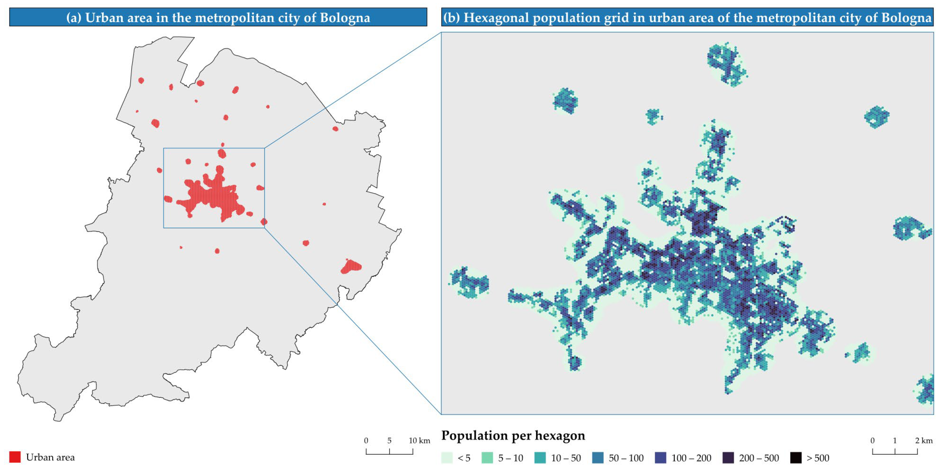
- Definition of starting points and spatialization of the resident population of the surrounding area. For the access points, a hexagonal mesh grid was created, considering the centers as the starting points of the routes and on which the spatialized population was allocated;
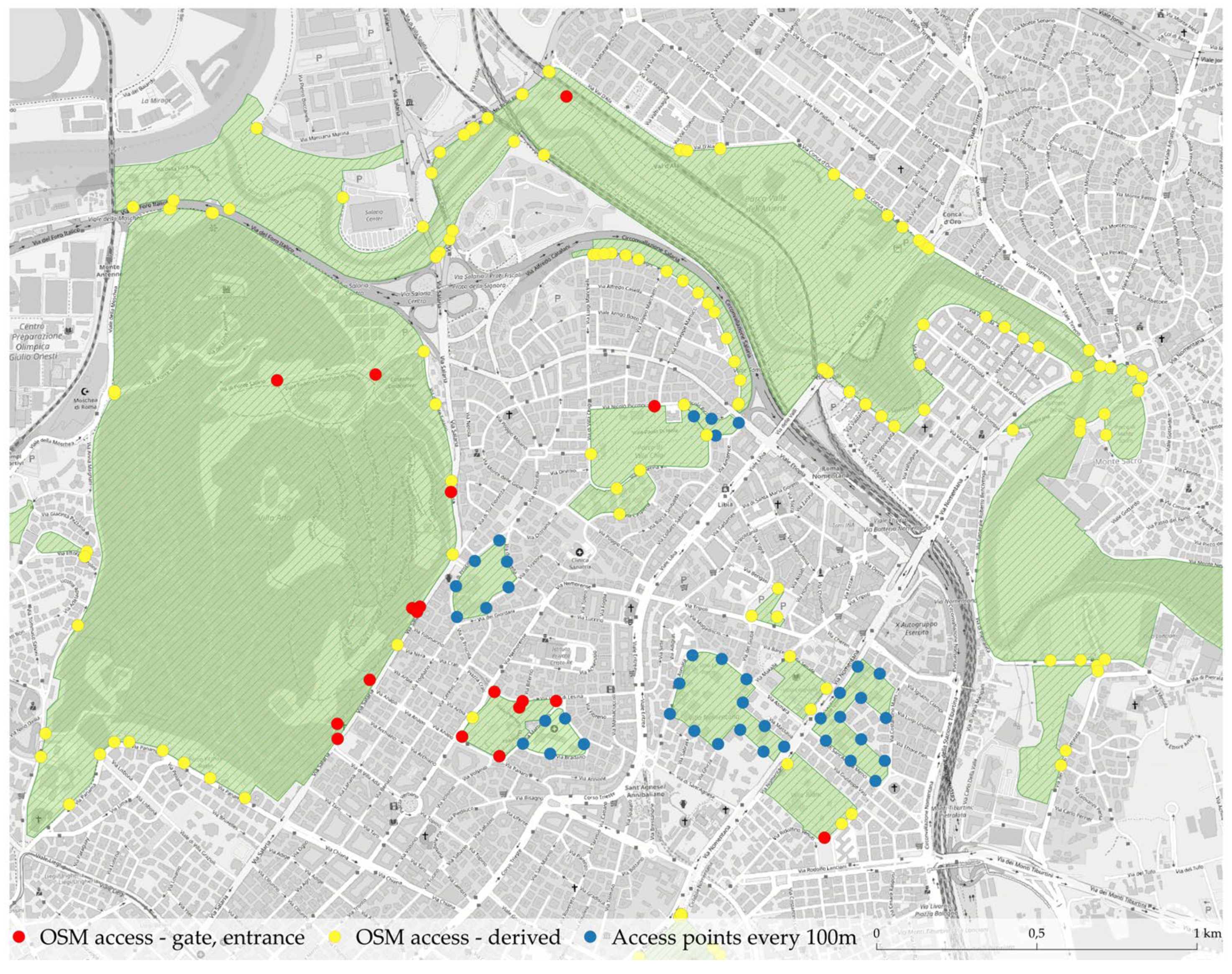
- Identification of GUPSs and related access points, with reference to Urban Atlas and OpenStreetMap data. For the OSM access points, those mapped by the “gate” and “entrance” tags were considered; in their absence, the intersection was made between GUPSs and roads or, thirdly, an access was inserted every 100 m along the perimeter of the GUPSs. For UA, it was only possible to consider one access point every 100 m along the perimeter;
- Definition of the routing network, to be covered on foot, to access the GUPSs from the starting points, defined from the OSM walkable road network;
- Identification of the shortest route to access from a starting point to the nearest GUPSs. For this purpose, it is considered that the inhabitants located in each hexagon of the grid have access to a green area if the nearest GUPSs can be reached by walking no more than 300 or 400 m. The threshold of 400 m is indicated by the metadata of SDG 11.7.1, while the threshold of 300 m refers to the IUCN 3-30-300 rule, which establishes that every inhabitant must be able to access a park within 300 m, 30 percent of each neighborhood must be wooded, and at least three trees should be visible from every window.
2.2. Study Area
2.3. Identification of Starting Points and Spatialization of the Population
2.3.1. Identification of Starting Points
2.3.2. Population Spatialization
- The most detailed population data were identified. In Italy, the ISTAT publishes population data aggregated by census sections (which offer a sub-municipal level of detail) every 10 years, starting from 1991. This study is based on the new ISTAT data updated to 2021.
- The population was allocated within the census sections by introducing the ISPRA national land consumption map (LCM) and the Copernicus Land Monitoring Service land cover and land use data as ancillary data. The LCM is a 10 m-resolution raster which provides an annually updated consumed land mapping for the Italian national territory. For each census section, the residential population was uniformly distributed across the LCM pixels classified as built-up areas for residential use and which fall under the section itself. In the absence of residential LCM pixels, the population was spread across all the built-up areas of the census section, or, in the absence of built-up pixels, a uniform distribution of the population was maintained across the entire census section. The population density information in the fictitious sections was finally added1.
- The previous operation produced a 10 m-resolution raster for the entire study area, which associates a population value to each LCM pixel. It was then crossed with the hexagonal grid to attribute to each hexagon the population of the underlying pixels. To calculate accessibility, the centroid of each hexagon is associated with the population of the entire hexagon.
2.4. Identification of GUPSs and Related Access Points
2.4.1. Identification of GUPSs
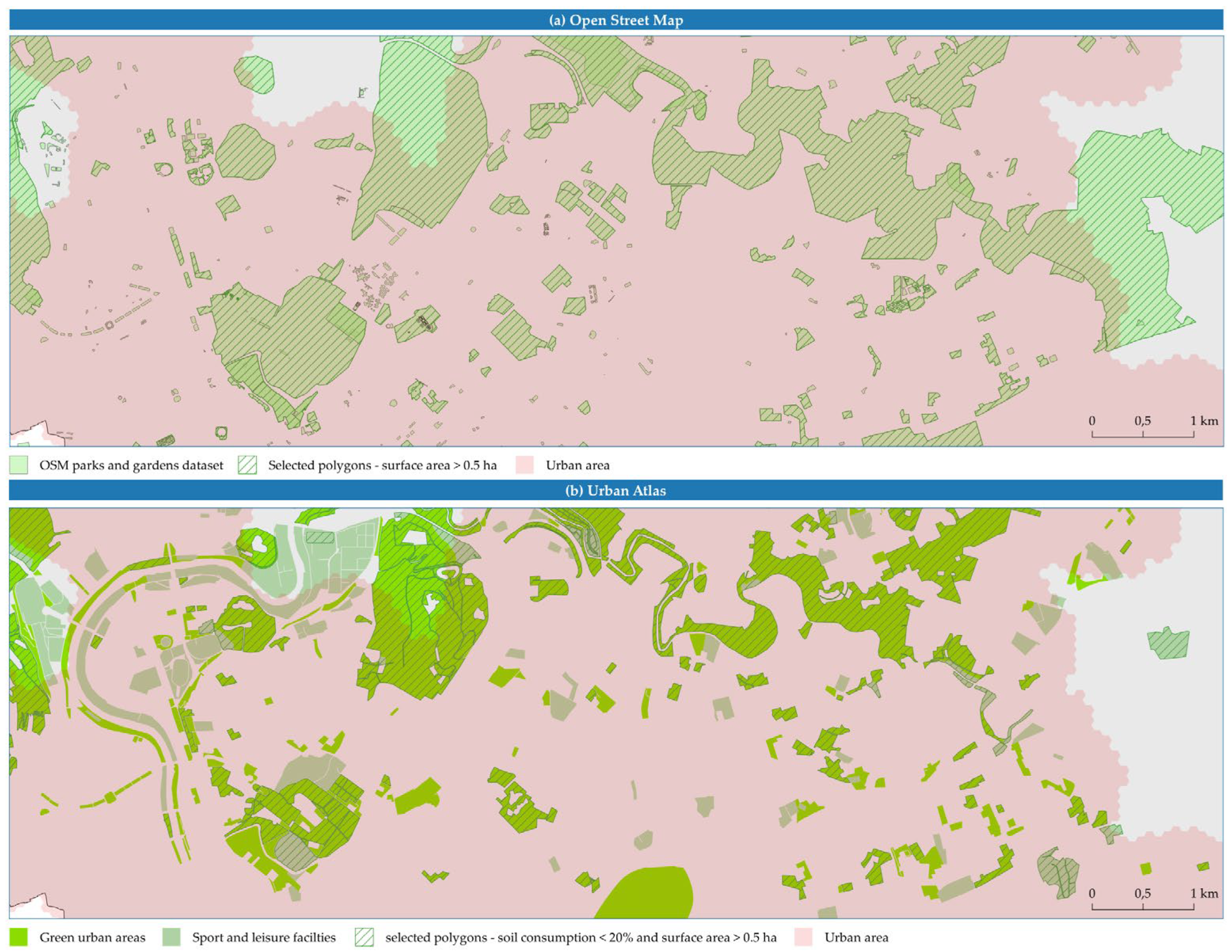
- From OpenStreetMap (OSM), the green spaces described by the key “Leisure” and the tags “Park” and “Garden” were extracted. Starting from the ITO Map Green space access map (which indicates a range of green spaces, their availability for use, and their access status) and analyzing OSM tags under the “Leisure” key [39], these two tags were identified as the most suitable for the selection of green open public spaces in the Italian context. The “parks” classified as “protected areas” by the tag “boundary” were excluded, since the perimeter of the protected areas is linked to a form of government of the territory and do not necessarily identify an area open to the public (in fact, within them it is also possible to find privately owned agricultural areas).
- From Copernicus Urban Atlas Land Cover/Land Use 2018 (UA), the class “1.4—Artificial non-agricultural vegetated areas” polygons were considered, which includes the subclasses of “1.4.1—Green urban areas” and “1.4.2—Sport and leisure facilities”. In detail, only polygons covered by artificial surfaces for less than 20% were selected (evaluated using the ISPRA LCM).
- The threshold for the percentage of consumed land on UA polygons was defined to exclude areas with a high presence of artificial surfaces, such as sports fields, stadiums, squares, theaters and auditoriums, cemeteries, riding stables, and sports centers.
- On the threshold on the minimum size of polygons, the IUCN rule 3-30-300 suggests considering green areas of at least one hectare; in this research, a threshold of 0.5 ha was defined for the entire study area to preserve many polygons smaller than one hectare (thus enhancing the information content of the input data) while maintaining areas large enough to guarantee the provision of ecosystem services, e.g., in terms of cooling capacity [45].
2.4.2. Identification of GUPS Access Points
- Intersection points between OSM streets and OSM GUPS polygons can be derived.
2.5. Creation of the Routing Network
2.6. Evaluation of Accessibility to GUPSs
2.7. Evaluation of Supporting Indicators
3. Results
3.1. Identification of Starting Points and Population Spatialization
3.2. Identification of GUPSs and Related Access Points
3.2.1. Identification of GUPSs
3.2.2. Identification of GUPS Access Points
3.3. Evaluation of Accessibility to GUPSs
3.4. Evaluation of GUPSs per Capita
4. Discussion
5. Conclusions
Author Contributions
Funding
Data Availability Statement
Conflicts of Interest
Appendix A. Selection of Suitable Green Spaces
| MC | OSM Patches | UA Patches | ||||
|---|---|---|---|---|---|---|
| Count (Total) | Count (>0.5 ha) | Surface (ha) (>0.5 ha) | Count (Total) | Count (CL < 20%, >0.5 ha) | Surface (ha) (CL < 20%, >0.5 ha) | |
| Tourin | 2990 | 624 | 2089 | 1808 | 594 | 1865 |
| Genoa | 636 | 108 | 235 | 442 | 129 | 248 |
| Milan | 4449 | 1380 | 4721 | 2217 | 877 | 3813 |
| Venice | 1238 | 336 | 854 | 981 | 256 | 670 |
| Bologna | 1913 | 1002 | 3623 | 787 | 411 | 1151 |
| Florence | 926 | 273 | 776 | 801 | 305 | 763 |
| Rome | 2924 | 765 | 5957 | 2847 | 1000 | 4892 |
| Naples | 3620 | 340 | 6694 | 1455 | 468 | 985 |
| Bari | 1114 | 151 | 281 | 624 | 104 | 200 |
| Reggio Calabria | 397 | 41 | 55 | 178 | 21 | 64 |
| Palermo | 436 | 74 | 425 | 551 | 137 | 302 |
| Messina | 497 | 41 | 96 | - | - | - |
| Catania | 2306 | 85 | 288 | 365 | 78 | 111 |
| Cagliari | 513 | 113 | 7516 | 365 | 146 | 314 |
| Total | 23,959 | 5333 | 33,610 | 13,421 | 4526 | 15,378 |
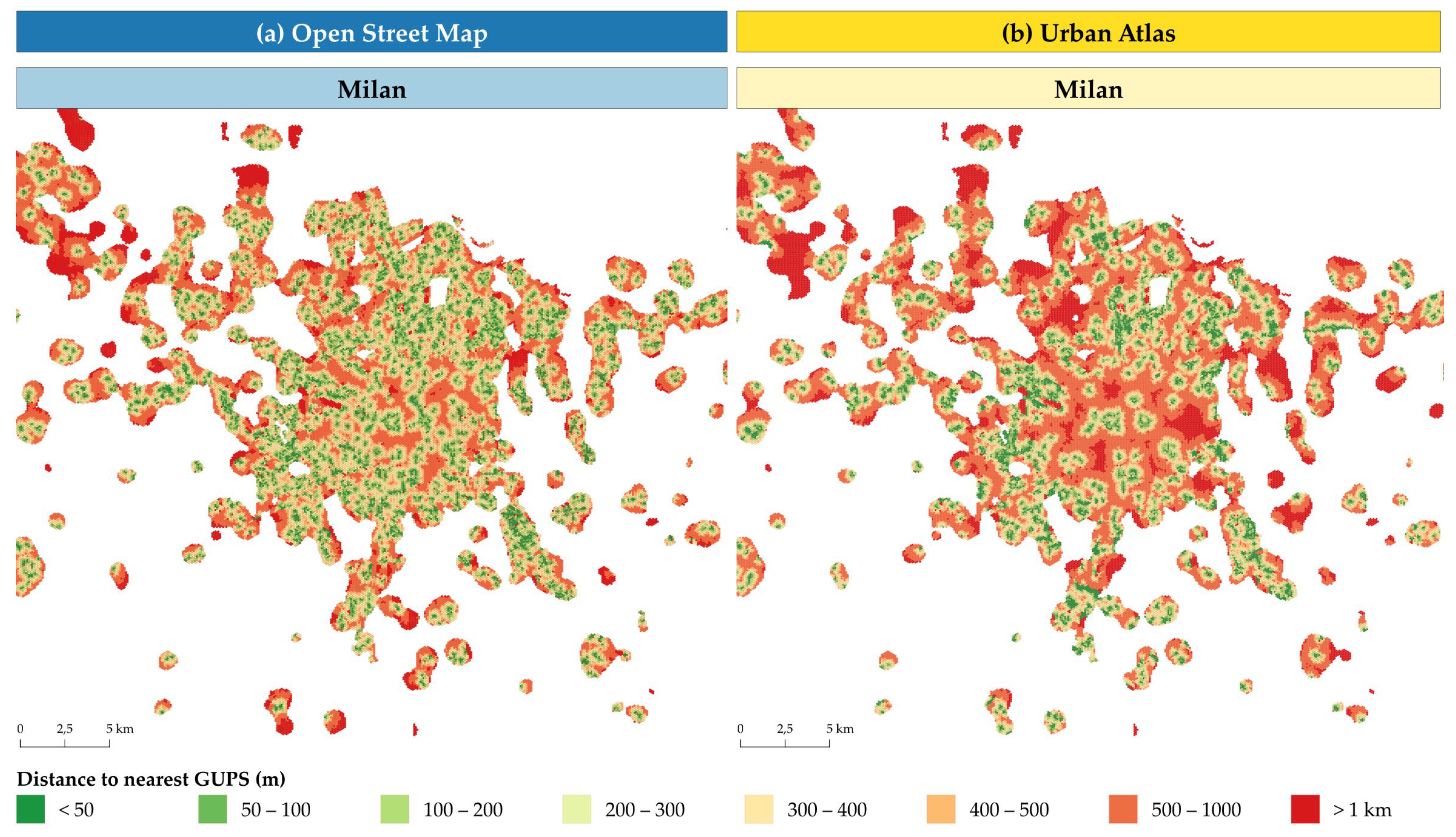
Appendix B. Accessibility Maps to GUPSs in MC According to OSM and UA
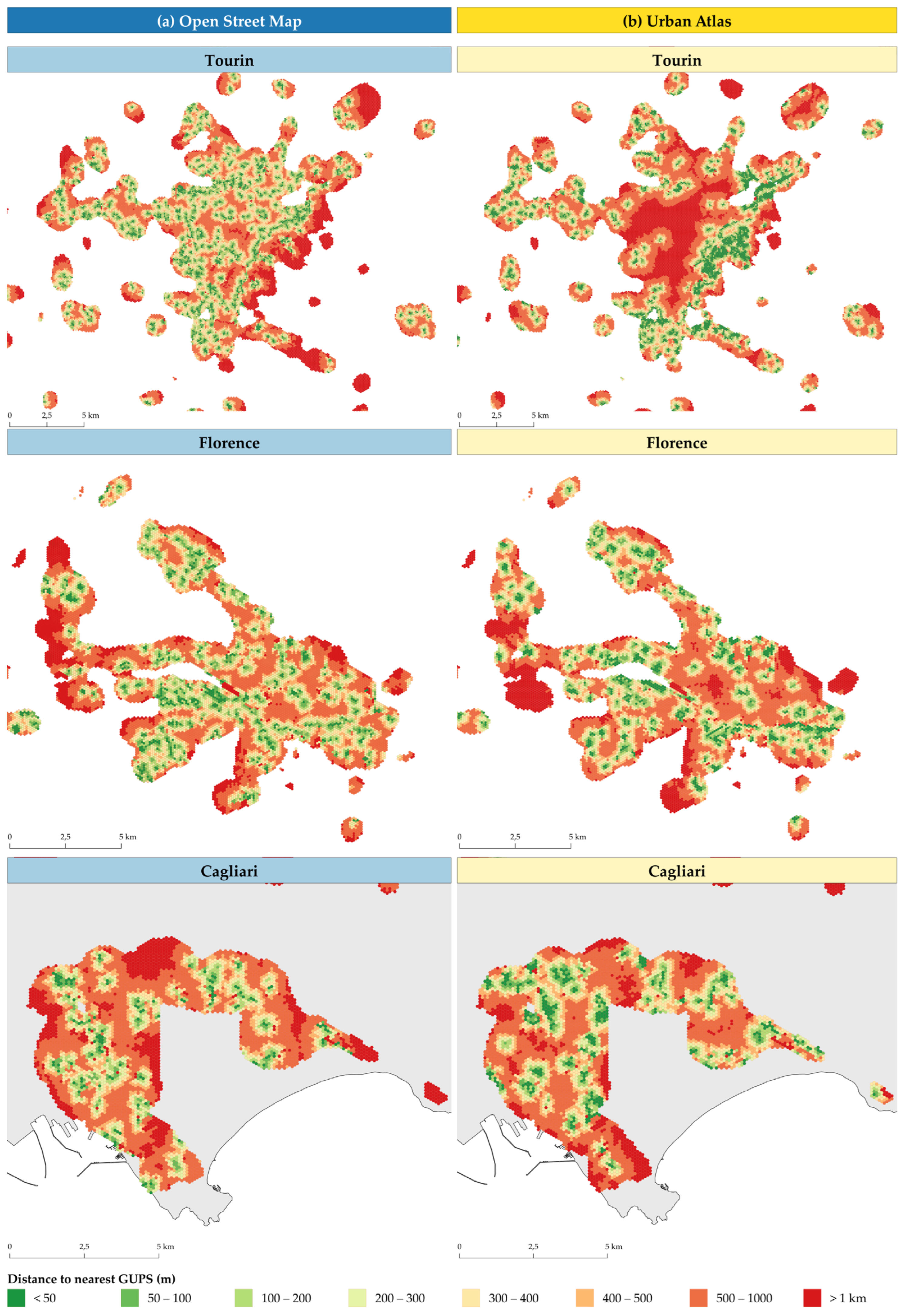
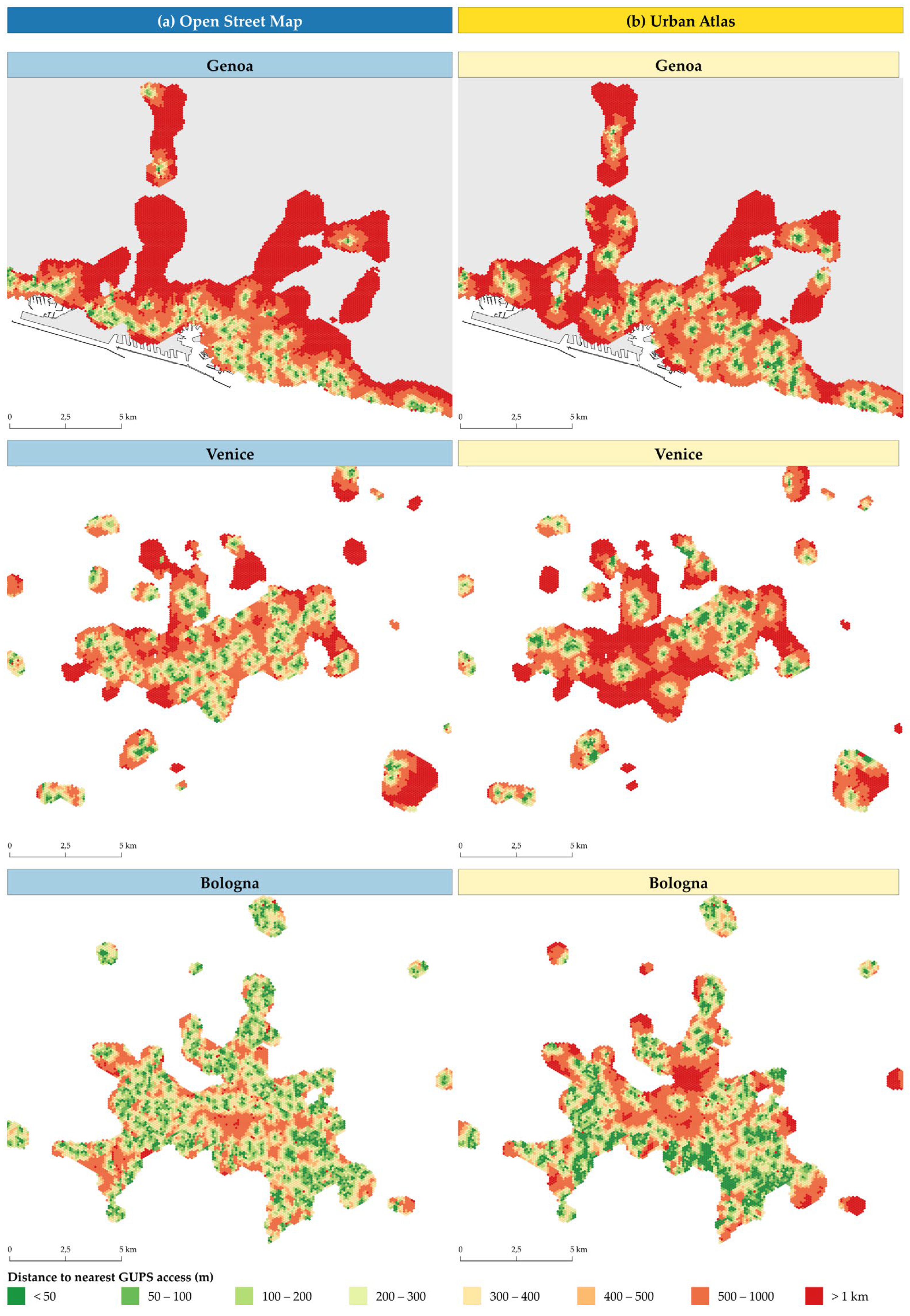
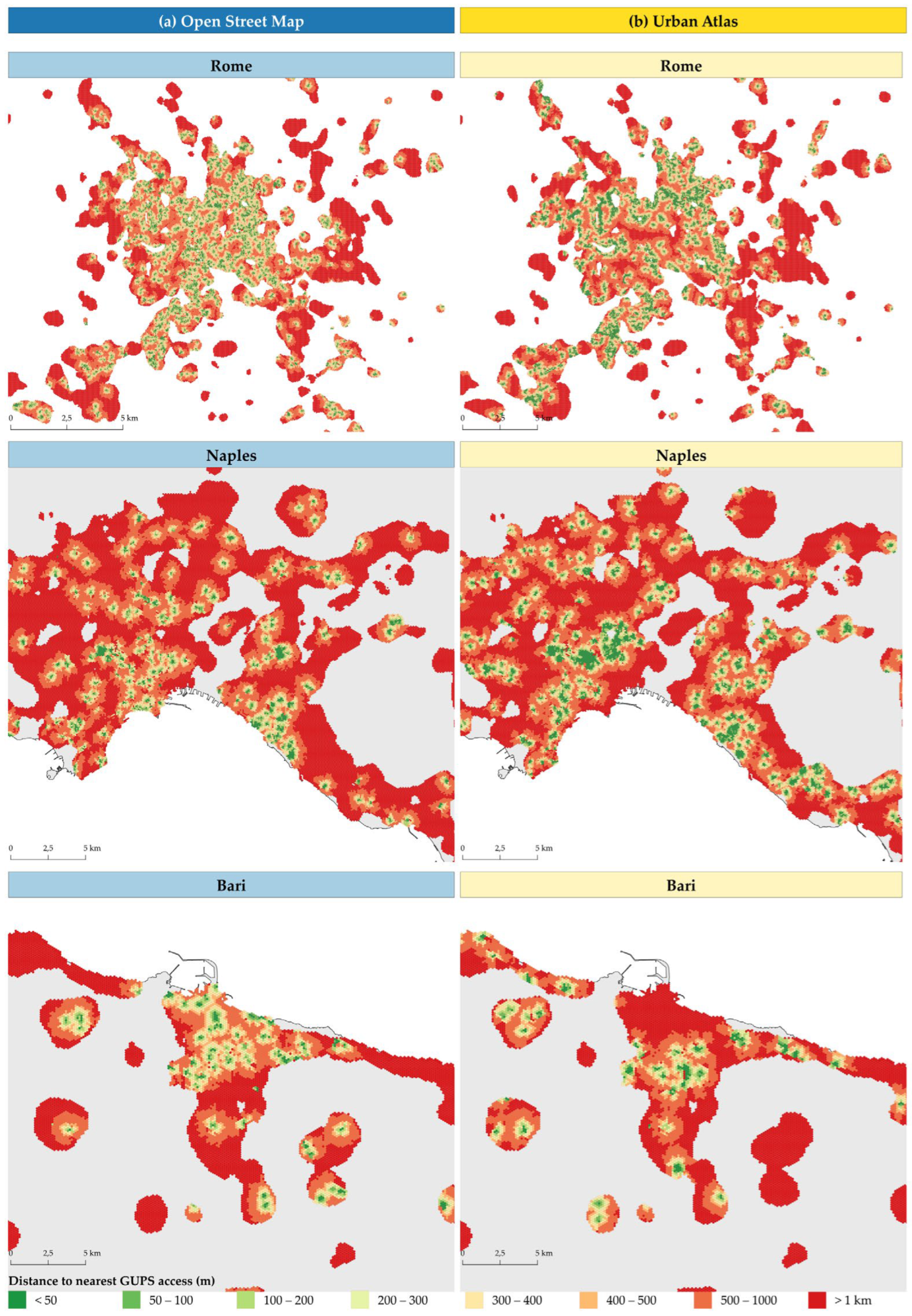
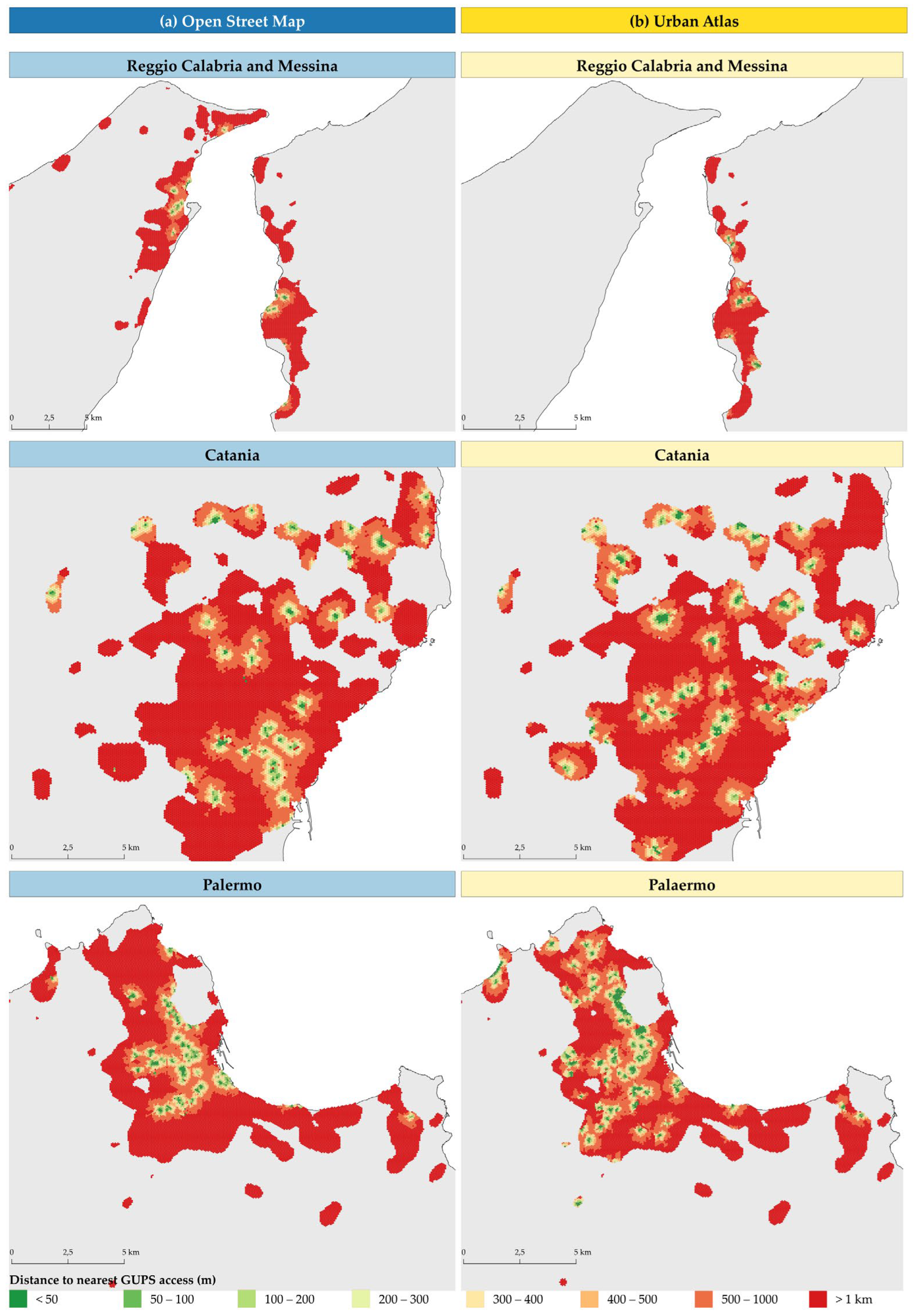
| 1. | The fictitious sections are introduced to allocate people without an official address, such as homeless people registered in the registry and allocated to a conventional address established by the municipality, individuals registered in the registry at associations or reception facilities, or residents in municipalities affected by seismic events. |
| 2. | The “Gate” tag indicates the presence of physical barriers such as doors or gates. |
| 3. | The “Entrance” tag is used to describe the point at which it is possible to enter a building or an enclosed area, in the absence of a physical barrier. |
References
- Department of Economic and Social Affairs, United Nations. Population Division World Urbanization Prospects: The 2018 Revision; ST/ESA/SER.A/420; United Nations: New York, NY, USA, 2018.
- Yeager, R.A.; Smith, T.R.; Bhatnagar, A. Green Environments and Cardiovascular Health. Trends Cardiovasc. Med. 2020, 30, 241–246. [Google Scholar] [CrossRef]
- Wong, N.H.; Tan, C.L.; Kolokotsa, D.D.; Takebayashi, H. Greenery as a Mitigation and Adaptation Strategy to Urban Heat. Nat. Rev. Earth Environ 2021, 2, 166–181. [Google Scholar] [CrossRef]
- Alkama, R.; Forzieri, G.; Duveiller, G.; Grassi, G.; Liang, S.; Cescatti, A. Vegetation-Based Climate Mitigation in a Warmer and Greener World. Nat. Commun. 2022, 13, 606. [Google Scholar] [CrossRef]
- Cohen-Cline, H.; Turkheimer, E.; Duncan, G.E. Access to Green Space, Physical Activity and Mental Health: A Twin Study. J. Epidemiol. Community Health (1978) 2015, 69, 523–529. [Google Scholar] [CrossRef]
- World Meteorological Organization (Ed.) State of the Global Climate 2023, 2024th ed.; Chair, Publications Board: Geneva, Switzerland, 2024; Volume 1347, ISBN 978-92-63-11347-4. [Google Scholar]
- Bočkarjova, M.; Kačalová, A. Greening of European Cities: Social Benefits of Urban Nature for Urban Air Quality. Eur. Stud. Rev. Eur. Law Econ. Politics 2021, 8, 177–204. [Google Scholar] [CrossRef]
- Piaggio, M. The Value of Public Urban Green Spaces: Measuring the Effects of Proximity to and Size of Urban Green Spaces on Housing Market Values in San José, Costa Rica. Land Use Policy 2021, 109, 105656. [Google Scholar] [CrossRef]
- Vandecasteele, I.; Baranzelli, C.; Siragusa, A.; Aurambout, J.P.; Alberti, V.; Alonso Raposo, M.; Attardo, C.; Auteri, D.; Barranco, R.; Batista e Silva, F.; et al. The Future of Cities—Opportunities, Challanges and the Way Forward; EUR (Luxembourg. Online); Publications Office: Luxembourg, 2019. [Google Scholar]
- Lanzani, A. L’Italia Degli Standard Urbanistici. Che Fare, Oggi? TERRITORIO 2020, 77–83. [Google Scholar] [CrossRef]
- Baioni, M.; Basso, S.; Caudo, G.; Franzese, A.; Marchigiani, E.; Munarin, S.; Renzoni, C.; Savoldi, P.; Tosi, M.C.; Vazzoler, N. Diritti in Città: Gli Standard Urbanistici in Italia Dal 1968 a Oggi; Donzelli: Roma, Italy, 2021; Volume 1, ISBN 8855220470. [Google Scholar]
- Bottalico, G.; Brini, S.; Vitali, W. Infrastrutture Verdi Urbane e Periurbane; ASviS, Ed.; ASviS: Roma, Italy, 2022. [Google Scholar]
- Atelli, M.; Blasi, C.; Boldini, G.; Cignini, B.; Cosenza, G.; Emiliani, V.; Marchetti, M.; Maria Maggiore, A.; Pericoli, T.; Ricciardi, A.; et al. Strategia Nazionale Del Verde Urbano. Foreste Resilienti Ed Eterogenee per La Salute e Il Benessere Dei Cittadini. 2018. Available online: https://www.mase.gov.it/sites/default/files/archivio/allegati/comitato%20verde%20pubblico/strategia_verde_urbano.pdf (accessed on 5 June 2024).
- Council of the European Union. On Nature Restoration and Amending Regulation; Office Journal of the European Union: Luxembourg, 2024; pp. 1–93. Available online: https://eur-lex.europa.eu/legal-content/EN/TXT/PDF/?uri=OJ:L_202401991 (accessed on 18 July 2024).
- Eurostat. Applying the Degree of Urbanisation: A Methodological Manual to Define Cities, Towns and Rural Areas for International Comparisons, 2021st ed.; Publications Office of the European Union: Luxembourg, 2021; ISBN 9789276203063. [Google Scholar]
- Taylor, L.; Hochuli, D.F. Defining Greenspace: Multiple Uses across Multiple Disciplines. Landsc Urban Plan 2017, 158, 25–38. [Google Scholar] [CrossRef]
- World Health Organization. Urban Green Spaces: A Brief for Action; WHO: Copenhagen, Denmark, 2017. [Google Scholar]
- Sangwan, A.; Saraswat, A.; Kumar, N.; Pipralia, S.; Kumar, A. Urban Green Spaces Prospects and Retrospect’s; Castanho, R.A., Fernández, J.C., Eds.; Urban Green Spaces; IntechOpen: London, UK, 2022. [Google Scholar]
- Huang, B.X.; Li, W.Y.; Ma, W.J.; Xiao, H. Space Accessibility and Equity of Urban Green Space. Land 2023, 12, 766. [Google Scholar] [CrossRef]
- Przewoźna, P.; Inglot, A.; Mielewczyk, M.; Maczka, K.; Matczak, P. Accessibility to Urban Green Spaces: A Critical Review of WHO Recommendations in the Light of Tree-Covered Areas Assessment. Ecol. Indic. 2024, 166, 112548. [Google Scholar] [CrossRef]
- Marinosci, I. La Classificazione Del Verde Urbano: Una Proposta Metodologica; Institute for Environmental Protection and Research (ISPRA): Roma, Italy, 2009; Volume 96, ISBN 9788844803032. [Google Scholar]
- Cardinali, M.; Beenackers, M.A.; van Timmeren, A.; Pottgiesser, U. The Relation between Proximity to and Characteristics of Green Spaces to Physical Activity and Health: A Multi-Dimensional Sensitivity Analysis in Four European Cities. Environ. Res. 2024, 241, 117605. [Google Scholar] [CrossRef]
- Konijnendijk, C.C. Evidence-Based Guidelines for Greener, Healthier, More Resilient Neighbourhoods: Introducing the 3–30–300 Rule. J. For. Res. 2023, 34, 821–830. [Google Scholar] [CrossRef]
- Annerstedt Van Den Bosch, M.; Egorov, A.I.; Mudu, P.; Uscila, V.; Barrdahl, M.; Kruize, H.; Kulinkina, A.; Staatsen, B.; Swart, W.; Zurlyte, I. Development of an Urban Green Space Indicator and the Public Health Rationale. Scand. J. Public Health 2016, 44, 159–167. [Google Scholar] [CrossRef]
- UN Habitat Metadata on SDGs Indicator 11.7.1 Indicator Category: Tier II. Available online: https://unhabitat.org/sites/default/files/2020/07/metadata_on_sdg_indicator_11.7.1.pdf (accessed on 10 January 2024).
- Silva, C.; Larsson, A. Challenges for Accessibility Planning and Research in the Context of Sustainable Mobility; OECD: Paris, France, 2018. [Google Scholar]
- Olivari, B.; Cipriano, P.; Napolitano, M.; Giovannini, L. Are Italian Cities Already 15-Minute? Presenting the Next Proximity Index: A Novel and Scalable Way to Measure It, Based on Open Data. J. Urban Mobil. 2023, 4, 100057. [Google Scholar] [CrossRef]
- Levine, J. A Century of Evolution of the Accessibility Concept. Transp. Res. D Transp. Environ. 2020, 83, 102309. [Google Scholar] [CrossRef]
- Kabisch, N.; Strohbach, M.; Haase, D.; Kronenberg, J. Urban Green Space Availability in European Cities. Ecol. Indic. 2016, 70, 586–596. [Google Scholar] [CrossRef]
- De La Barrera, F.; Reyes-Paecke, S.; Banzhaf, E. Indicators for Green Spaces in Contrasting Urban Settings. Ecol. Indic. 2016, 62, 212–219. [Google Scholar] [CrossRef]
- Fang, D.; Liu, D.; Kwan, M.-P. Evaluating Spatial Variation of Accessibility to Urban Green Spaces and Its Inequity in Chicago: Perspectives from Multi-Types of Travel Modes and Travel Time. Urban For. Urban Green 2025, 104, 128593. [Google Scholar] [CrossRef]
- Ekkel, E.D.; de Vries, S. Nearby Green Space and Human Health: Evaluating Accessibility Metrics. Landsc. Urban Plan 2017, 157, 214–220. [Google Scholar] [CrossRef]
- EC. Mapping Guide v6.2 for a European Urban Atlas Regional Policy; EC: Brussels, Belgium, 2020. [Google Scholar]
- Poelman, H. A Walk to the Park? Assessing Access to Green Areas in Europe’s Cities; Regional and Urban Policy: Brussels, Belgium, 2018. [Google Scholar]
- Giuliani, G.; Petri, E.; Interwies, E.; Vysna, V.; Guigoz, Y.; Ray, N.; Dickie, I. Modelling Accessibility to Urban Green Areas Using Open Earth Observations Data: A Novel Approach to Support the Urban SDG in Four European Cities. Remote Sens. 2021, 13, 422. [Google Scholar] [CrossRef]
- La Rosa, D. Accessibility to Greenspaces: GIS Based Indicators for Sustainable Planning in a Dense Urban Context. Ecol. Indic. 2014, 42, 122–134. [Google Scholar] [CrossRef]
- Benati, G.; Calcagni, F.; Matellozzo, F.; Ghermandi, A.; Langemeyer, J. Unequal Access to Cultural Ecosystem Services of Green Spaces within the City of Rome—A Spatial Social Media-Based Analysis. Ecosyst. Serv. 2024, 66, 101594. [Google Scholar] [CrossRef]
- UN Habitat. Metadata on SDGs Indicator 11.3.1. Indicator Category: Tier II. Available online: https://unhabitat.org/sites/default/files/2020/07/metadata_on_sdg_indicator_11.3.1.pdf (accessed on 28 September 2023).
- Ito World Green Space Access ITO Map. Available online: https://wiki.openstreetmap.org/wiki/Ito_Map (accessed on 22 October 2024).
- Burdziej, J. Using Hexagonal Grids and Network Analysis for Spatial Accessibility Assessment in Urban Environments—A Case Study of Public Amenities in Toruń. Misc. Geogr. 2019, 23, 99–110. [Google Scholar] [CrossRef]
- Istituto Nazionale di Statistica (ISTAT). Basi Territoriali Anni 1991, 2001, 2011 e 2021; ISTAT: Roma, Italy, 2024. [Google Scholar]
- Cimini, A.; De Fioravante, P.; Riitano, N.; Dichicco, P.; Calò, A.; Scarascia Mugnozza, G.; Marchetti, M.; Munafò, M. Land Consumption Dynamics and Urban–Rural Continuum Mapping in Italy for SDG 11.3.1 Indicator Assessment. Land 2023, 12, 155. [Google Scholar] [CrossRef]
- Wang, W.; Zhou, L.; Zhu, A.-X.; Lv, G. Isoline Extraction Based on a Global Hexagonal Grid. Cartogr. Geogr. Inf. Sci. 2024, 1–15. [Google Scholar] [CrossRef]
- Burdziej, J. A Web-Based Spatial Decision Support System for Accessibility Analysis-Concepts and Methods. Appl. Geomat. 2012, 4, 75–84. [Google Scholar] [CrossRef]
- Yu, Z.; Yang, G.; Zuo, S.; Jørgensen, G.; Koga, M.; Vejre, H. Critical Review on the Cooling Effect of Urban Blue-Green Space: A Threshold-Size Perspective. Urban Urban Green 2020, 49, 126630. [Google Scholar] [CrossRef]
- European Environment Agency CLC+ Backbone Product Specification and User Manual for CLC+ Backbone Raster Product 2021. Available online: https://land.copernicus.eu/en/products/clc-backbone/clc-backbone-2021 (accessed on 28 July 2023).
- OpenStreetMap Community. Humanitarian OpenStreetMap Team LearnOSM. Available online: https://learnosm.org/en/contribute/ (accessed on 22 October 2023).
- Munafò, M. Consumo Di Suolo, Dinamiche Territoriali e Servizi Ecosistemici. Edizione 2023, 37, 2023. [Google Scholar]
- Albanese, A.; Cecili, G.; Cimini, A.; Congedo, L.; D’Agata, A.; De Fioravante, P.; Dichicco, P.; Falanga, V.; Marinosci, I.; Mariani, L.; et al. Linee Guida per Il Monitoraggio Del Consumo Di Suolo Nell’ambito Delle Attività Del SNPA 50. 2024. Available online: https://www.snpambiente.it/wp-content/uploads/2024/05/Linee-Guida-SNPA-50_24.pdf (accessed on 20 September 2024).
- Decreto Ministeriale 2 Aprile 1968. Limiti Inderogabili Di Densità Edilizia, Di Altezza, Di Distanza Tra i Fabbricati e Rapporti Massimi Tra Spazi Destinati Agli Insediamenti Residenziali e Produttivi e Spazi Pubblici o Riservati Alle Attività Collettive Ai Fini Della Formazione Dei Nuovi Strumenti Urbanistici o Della Revisione Di Quelli Esistenti, Ai Sensi Dell’art.17 Della Legge 6 Agosto 1967, n.765; pp. 2340–2342. Available online: https://www.gazzettaufficiale.it/eli/id/1968/04/16/1288Q004/sg (accessed on 2 April 2024).
- van Dillen, S.M.E.; de Vries, S.; Groenewegen, P.P.; Spreeuwenberg, P. Greenspace in Urban Neighbourhoods and Residents’ Health: Adding Quality to Quantity. J. Epidemiol. Community Health (1978) 2012, 66, e8. [Google Scholar] [CrossRef]
- ARTA Abruzzo VeBS Il Buon Uso Degli Spazi Verdi e Blu per La Promozione Del Benessere e Della Salute. Available online: https://vebs.it/ (accessed on 22 May 2024).
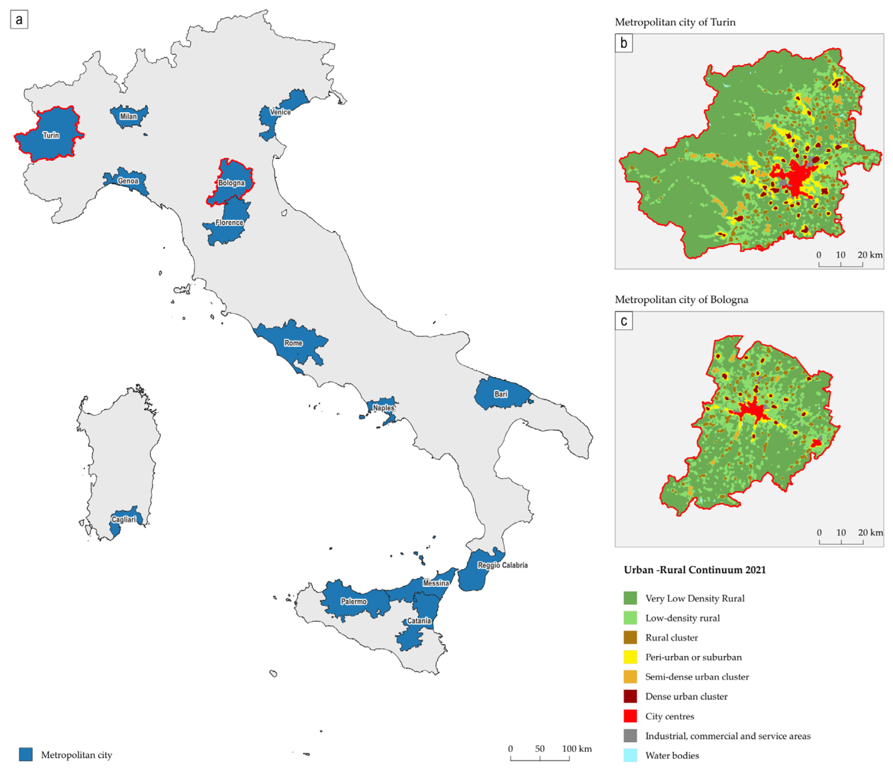



| MC | Total Surface | Urban Area | |
|---|---|---|---|
| ha | ha | % | |
| Tourin | 682,973 | 25,319 | 3.7 |
| Genoa | 183,517 | 10,855 | 5.9 |
| Milan | 157,674 | 49,513 | 31.4 |
| Venice | 247,039 | 8770 | 3.6 |
| Bologna | 370,199 | 9288 | 2.5 |
| Florence | 351,351 | 11,937 | 3.4 |
| Rome | 535,581 | 61,856 | 11.5 |
| Naples | 117,398 | 50,126 | 42.7 |
| Bari | 382,540 | 14,670 | 3.8 |
| Reggio Calabria | 318,303 | 5789 | 1.8 |
| Palermo | 499,302 | 14,282 | 2.9 |
| Messina | 324,678 | 6294 | 1.9 |
| Catania | 355,303 | 15,800 | 4.4 |
| Cagliari | 124,964 | 6216 | 5.0 |
| Total | 4,650,821 | 290,716 | 6.3 |
| MC | Total Population | Population in Urban Area | |
|---|---|---|---|
| Inhabitants | Inhabitants | % of Total Pop. | |
| Tourin | 2,208,370 | 1,556,719 | 70.5 |
| Genoa | 817,402 | 654,077 | 80.0 |
| Milan | 3,214,630 | 2,978,997 | 92.7 |
| Venice | 836,916 | 368,138 | 44.0 |
| Bologna | 1,010,812 | 562,695 | 55.7 |
| Florence | 987,260 | 626,038 | 63.4 |
| Rome | 4,216,874 | 3,384,763 | 80.3 |
| Naples | 2,931,250 | 2,710,728 | 92.5 |
| Bari | 1,226,784 | 1,030,954 | 84.0 |
| Reggio Calabria | 522,127 | 252,003 | 48.3 |
| Palermo | 1,208,991 | 868,424 | 71.8 |
| Messina | 603,229 | 284,205 | 47.1 |
| Catania | 1,077,515 | 803,756 | 74.6 |
| Cagliari | 421,688 | 350,559 | 83.1 |
| Total | 21,283,848 | 16,432,056 | 77.2 |
| GUPSs | ||||
|---|---|---|---|---|
| OSM | UA | |||
| Città Metropolitana | ha | % on Urban Area | ha | % on Urban Area |
| Tourin | 1603 | 6.3 | 1117 | 4.4 |
| Genoa | 214 | 2.0 | 135 | 1.2 |
| Milan | 4208 | 8.5 | 3050 | 6.2 |
| Venice | 300 | 3.4 | 670 | 7.6 |
| Bologna | 1430 | 15.4 | 678 | 7.3 |
| Florence | 776 | 6.5 | 510 | 4.3 |
| Rome | 5957 | 9.6 | 3222 | 5.2 |
| Naples | 911 | 1.8 | 864 | 1.7 |
| Bari | 188 | 1.3 | 124 | 0.8 |
| Reggio Calabria | 22 | 0.4 | 15 | 0.3 |
| Palermo | 353 | 2.5 | 212 | 1.5 |
| Messina | 45 | 0.7 | - | - |
| Catania | 88 | 0.6 | 64 | 0.4 |
| Cagliari | 264 | 4.2 | 153 | 2.5 |
| Total | 16,359 | 5.6 | 10,814 | 3.7 |
| Number of Accesses to GUPSs | ||||
|---|---|---|---|---|
| MC | Gate/Entrance | Derivati | ogni 100 m | Total |
| Tourin | 279 | 2.718 | 794 | 3.791 |
| Genoa | 130 | 569 | 49 | 748 |
| Milan | 942 | 8.221 | 845 | 10.008 |
| Venice | 77 | 1.263 | 437 | 1.777 |
| Bologna | 192 | 4.818 | 660 | 5.670 |
| Florence | 113 | 2.147 | 549 | 2.809 |
| Rome | 729 | 758 | 4.429 | 5.916 |
| Naples | 139 | 1.036 | 857 | 2.032 |
| Bari | 58 | 431 | 258 | 747 |
| Reggio Calabria | 9 | 129 | 51 | 189 |
| Palermo | 36 | 233 | 139 | 408 |
| Messina | 20 | 68 | 81 | 169 |
| Catania | 61 | 200 | 201 | 462 |
| Cagliari | 66 | 674 | 180 | 920 |
| Total | 2.851 | 23.265 | 9.530 | 35.646 |
| Population That Has Access to a GUPS | ||||||||
|---|---|---|---|---|---|---|---|---|
| OSM | UA | |||||||
| Within 300 m | Within 400 m | Within 300 m | Within 400 m | |||||
| MC | Number of Inhab. | % * | Number of Inhab. | % * | Number of Inhab. | % * | Number of Inhab. | % * |
| Tourin | 590,640 | 37.9 | 839,799 | 53.9 | 279,268 | 17.9 | 420,090 | 27 |
| Genoa | 124,725 | 19.1 | 192,809 | 29.5 | 103,234 | 15.8 | 159,562 | 24.4 |
| Milan | 1,484,951 | 49.8 | 1,978,162 | 66.4 | 891,384 | 29.9 | 1,283,206 | 43.1 |
| Venice | 104,030 | 28.3 | 155,779 | 42.3 | 75,664 | 20.6 | 114,489 | 31.1 |
| Bologna | 318,255 | 56.6 | 411,987 | 73.2 | 217,860 | 38.7 | 289,490 | 51.4 |
| Florence | 247,748 | 39.6 | 347,600 | 55.5 | 163,729 | 26.2 | 239,398 | 38.2 |
| Rome | 994,934 | 29.4 | 1,427,518 | 42.2 | 738,062 | 21.8 | 1,031,376 | 30.5 |
| Naples | 333,286 | 12.3 | 514,773 | 19 | 469,901 | 17.3 | 677,108 | 25 |
| Bari | 193,773 | 18.8 | 308,033 | 29.9 | 56,421 | 5.5 | 86,897 | 8.4 |
| Reggio Calabria | 15,958 | 6.3 | 25,114 | 10 | 6830 | 2.7 | 10,101 | 4 |
| Palermo | 85,910 | 9.9 | 133,860 | 15.4 | 108,735 | 12.5 | 166,965 | 19.2 |
| Messina | 19,836 | 7 | 32,444 | 11.4 | - | - | - | - |
| Catania | 58,901 | 7.3 | 99,027 | 12.3 | 33,929 | 4.2 | 54,310 | 6.8 |
| Cagliari | 67,043 | 19.1 | 107,180 | 30.6 | 77,038 | 22 | 117,162 | 33.4 |
| Total | 4,639,989 | 28.2 | 6,574,084 | 40 | 3,222,055 | 19.6 | 4,650,153 | 28.3 |
| MC | Urban Green Spaces | UGS per Capita | OSM GUPSs per Capita | UA GUPSs per Capita |
|---|---|---|---|---|
| [ha] | [m2/ab] | [m2/ab] | [m2/ab] | |
| Tourin | 8288 | 53.2 | 10.3 | 7.2 |
| Genoa | 5185 | 79.3 | 3.3 | 2.1 |
| Milan | 18,534 | 62.2 | 14.1 | 10.2 |
| Venice | 3035 | 82.4 | 8.1 | 18.2 |
| Bologna | 3862 | 68.6 | 25.4 | 12.0 |
| Florence | 5108 | 81.6 | 12.4 | 8.1 |
| Rome | 31,110 | 91.9 | 17.6 | 9.5 |
| Naples | 21,808 | 80.4 | 3.4 | 3.2 |
| Bari | 5117 | 49.6 | 1.8 | 1.2 |
| Reggio di Calabria | 2091 | 83.0 | 0.9 | 0.6 |
| Palermo | 5882 | 67.7 | 4.1 | 2.4 |
| Messina | 2709 | 95.3 | 1.6 | - |
| Catania | 6916 | 86.0 | 1.1 | 0.8 |
| Cagliari | 2441 | 69.6 | 7.5 | 4.4 |
| Total | 122,087 | 74.3 | 10.0 | 6.6 |
Disclaimer/Publisher’s Note: The statements, opinions and data contained in all publications are solely those of the individual author(s) and contributor(s) and not of MDPI and/or the editor(s). MDPI and/or the editor(s) disclaim responsibility for any injury to people or property resulting from any ideas, methods, instructions or products referred to in the content. |
© 2024 by the authors. Licensee MDPI, Basel, Switzerland. This article is an open access article distributed under the terms and conditions of the Creative Commons Attribution (CC BY) license (https://creativecommons.org/licenses/by/4.0/).
Share and Cite
Cimini, A.; De Fioravante, P.; Marinosci, I.; Congedo, L.; Cipriano, P.; Dazzi, L.; Marchetti, M.; Scarascia Mugnozza, G.; Munafò, M. Green Urban Public Spaces Accessibility: A Spatial Analysis for the Urban Area of the 14 Italian Metropolitan Cities Based on SDG Methodology. Land 2024, 13, 2174. https://doi.org/10.3390/land13122174
Cimini A, De Fioravante P, Marinosci I, Congedo L, Cipriano P, Dazzi L, Marchetti M, Scarascia Mugnozza G, Munafò M. Green Urban Public Spaces Accessibility: A Spatial Analysis for the Urban Area of the 14 Italian Metropolitan Cities Based on SDG Methodology. Land. 2024; 13(12):2174. https://doi.org/10.3390/land13122174
Chicago/Turabian StyleCimini, Angela, Paolo De Fioravante, Ines Marinosci, Luca Congedo, Piergiorgio Cipriano, Leonardo Dazzi, Marco Marchetti, Giuseppe Scarascia Mugnozza, and Michele Munafò. 2024. "Green Urban Public Spaces Accessibility: A Spatial Analysis for the Urban Area of the 14 Italian Metropolitan Cities Based on SDG Methodology" Land 13, no. 12: 2174. https://doi.org/10.3390/land13122174
APA StyleCimini, A., De Fioravante, P., Marinosci, I., Congedo, L., Cipriano, P., Dazzi, L., Marchetti, M., Scarascia Mugnozza, G., & Munafò, M. (2024). Green Urban Public Spaces Accessibility: A Spatial Analysis for the Urban Area of the 14 Italian Metropolitan Cities Based on SDG Methodology. Land, 13(12), 2174. https://doi.org/10.3390/land13122174


