Abstract
With the deceleration of urban expansion, the adaptive reuse of industrial heritage buildings has emerged as a novel area of research. In previous times, the majority of approaches to adapting industrial heritage buildings relied on experiential knowledge, which lacked the ability to objectively assess the relationship between spaces and engage in rational planning. However, the social network analysis method offers an objective and comprehensive means of perceiving the spatial structure and analyzing its issues from a detached perspective. This study presents a proposal for addressing three spatial challenges encountered during the conversion of industrial heritage buildings into public buildings. It also suggests spatial optimization strategies to overcome these challenges. The Sanlinqiao Thermal Bottle Factory is selected as the research subject, and a spatial network structure model is constructed to analyze the existing issues using the social network analysis method. The proposed spatial optimization strategies are then applied, and the optimized space is evaluated through a re-analysis of the spatial layout. The spatial utilization rate has been significantly improved, leading to an effective enhancement of the spatial vitality of the site. This study presents a spatial strategy aimed at converting industrial heritage buildings into public buildings, thereby offering valuable insights for similar projects involving the transformation of industrial heritage sites.
1. Introduction
Currently, the incremental expansion of large cities has shown limited results. In the context of new normal economic development, urban growth has transitioned from incremental expansion to stock optimization [1]. Industrial heritage not only contributes to the stock of urban space but also serves as a significant historical testament to urban development. It possesses valuable historical research value and offers practical opportunities for adaptive reuse. However, the recent trend of de-industrialization has led to the disappearance of numerous industrial heritage sites [2]. Ensuring the continuity of a city’s historical lineage, conserving resources, and achieving sustainable development have become urgent issues in the development and construction of cities worldwide [3]. Consequently, there has been a shift towards the adaptive reuse of industrial heritage buildings by assigning new functions to old structures [4,5,6].
In building renovation projects, the rational utilization of existing space is of utmost importance [6]. However, recent research on the adaptive reuse of industrial heritage buildings has paid inadequate attention to the rationality of space utilization. As a result, formulating general strategies for specific spaces and predicting the effectiveness of retrofitting measures have proven challenging, leading to the potential wastage of financial and material resources (Table 1). Furthermore, evaluating the effectiveness of these measures has predominantly relied on subjective questionnaire surveys, making it difficult to objectively assess their impact and lacking a comprehensive analysis of space utilization rationality (Table 1). Therefore, this study aims to explore spatial strategies for the adaptive reuse of industrial heritage buildings and evaluate retrofitting effects using objective quantitative methods.

Table 1.
Documentation.
Table 1.
Documentation.
| Bibliography | Research Object | Research Methodology | Conclusions | Times |
|---|---|---|---|---|
| Participation in the reuse of industrial heritage sites: the case of Oberschöneweide, Berlin [7] | Urban brownfield reuse | Use of semi-structured interviews to investigate public satisfaction with the current aesthetic and functional state of regeneration in the Randwick area | Two generic reuse strategies are proposed: “re-new production” and “entertainment” | 2016 |
| Perceived space, conceived space, lived space: The trialectics of spatiality on the example of a brownfield regeneration investment in Budapest [8] | Study of public perceptions, knowledge, and attitudes toward brownfield remediation projects in Budapest through a questionnaire survey | Respondents’ perceptions and conceptualizations of sites vary according to their socio-demographic backgrounds, how they use the site, and for what purpose | 2017 | |
| Re-reuse of regenerated brownfields: Lessons from an Eastern European post-industrial city [9] | A questionnaire to find out how residents and visitors to the Randwick area perceive a range of brownfield reuse options | Future brownfield uses such as cultural/sports and children’s parks were the most favored options, with a general lack of specific ideas from respondents about alternative reuse options for brownfield sites | 2018 | |
| A Multicriteria Approach to Adaptive Reuse of Industrial Heritage: Case Studies of Riverside Power Plants [10] | Power plant transformed into an art gallery | Use of the value/intensity approach to comprehensively evaluate the effectiveness of industrial heritage renovation through the study of environmental, social, economic, and urban planning factors | Adaptive reuse projects for industrial buildings assessed on the basis of determinants, using value scales to quantify environmentally relevant building performance | 2023 |
| Industrial Heritage Buildings in Cyprus Spatial Experience of the Nicosia Municipal Arts Centre [11] | Power station transformed into arts center | Investigating the tangible and intangible qualities of space using phenomenological research, a qualitative research methodology | Creating a dynamic framework for analyzing how humans perceive space in reused buildings, explaining the spatial perceptions of architectural design in terms of human responses to buildings, and using this to guide the design of future renovations | 2021 |
| Industrial building adaptive reuse for museum. Factors affecting visitors’ perceptions of the sustainable urban development potential [12] | Brewery transformed into art museum | Use of questionnaires to collect data on tourists’ perceptions of the impact of adaptive reuse projects on nearby metropolitan environments and the factors influencing them, and use of multivariate regression analyses to determine the factors influencing tourists’ perceptions | Adaptive reuse development can contribute to the sustainable development of local and neighboring cities | 2023 |
| Critical sustainable development factors in the adaptive reuse of urban industrial buildings. A fuzzy DEMATEL approach [13] | Presentation of a comprehensive list of factors affecting local sustainable development after the recent reuse of the FIX building: economic, social, environmental, cultural, using the fuzzy DEMATEL method to obtain interrelationships between the factors | Adaptive reuse projects employ certain strategies to achieve an optimal balance between initial investment, energy savings, minimization of environmental impact, heritage preservation, and urban regeneration | 2019 | |
| Adaptive reuse for sustainable development and land use: A multivariate linear regression analysis estimating key determinants of public perceptions [14] | Conducting a questionnaire survey and analyzing the factors influencing tourists’ views using multiple linear regression to investigate the impact of adaptive reuse of culturally important urban industrial facilities on the overall redevelopment of the city | A combination of predefined conceptual theories, policy principles, and practical tools can strike a good balance between investment capital, ecological protection, and cultural heritage preservation | 2023 | |
| Authenticity, involvement, and nostalgia: Understanding visitor satisfaction with an adaptive reuse heritage site in urban China [15] | Urban heritage sites converted to commercial buildings | Examining the effects of perceived authenticity, participation, and nostalgia on tourists’ satisfaction with the Lingnan Tiandi reuse project in Foshan through questionnaire survey methods | Engagement is the strongest predictor of visitor satisfaction, followed by the nostalgic experience, and the article offers some suggestions for developing and marketing reuse heritage sites | 2020 |
| From Maslow to architectural spaces: The assessment of reusing old industrial buildings [16] | Old mill converted to public building | Use Maslow’s hierarchy of needs theory, fuzzy comprehensive evaluation method to evaluate the effectiveness of project transformation | Translating Maslow’s Hierarchy of Needs theory into building assessment and developing an assessment framework to analyze the success of reusing old industrial buildings as public buildings | 2022 |
| Housing preferences for adaptive reuse of office and industrial buildings: Demand side [17] | Conversion of old industrial buildings into residential housing | Preference of respondents to live in adapted buildings measured by questionnaire, discrete modeling | Such analyses enable decision makers to make better judgments on demolition and retrofitting and to better identify the potential for building use and its economic sustainability, leading to a reduction in construction waste and an increase in energy efficiency | 2020 |
The second subsection of this paper initially identifies three objective spatial challenges that must be addressed during the transformation of industrial heritage buildings: functional layout, spatial accessibility, and pathway richness. Corresponding transformation strategies are then proposed, including functional matching, the creation of grey space, enhancement of connections between edge spaces and the overall factory, and the stimulation of public space vitality. The third and fourth subsections of this paper apply the methods proposed in the previous section to an actual case study and analyze the transformational effects. Finally, the Section 5 summarizes the findings and discusses the importance and value of this research for future projects.
2. Literature Review and Research Framework
2.1. Spatial Issues Facing the Reuse of Industrial Heritage
Industrial buildings possess open internal spaces, regular floor plans, and a high degree of adaptability for renovation and utilization [18]. During the transformation process, the design should focus on expressing, exploring, and revitalizing the potential of the space [19].
Industrial buildings are purpose-built structures primarily used for the production, storage, or processing of goods. They typically feature large-scale open spaces with minimal or no internal partitions [20]. In contrast, public buildings serve a variety of social, service, and cultural functions, often requiring diverse spatial compositions and more internal partitions to accommodate different activities [21]. Transforming industrial buildings into public spaces involves converting these expansive industrial spaces into smaller, adaptable areas suitable for various civil functions [22]. Therefore, renovation efforts should involve a reclassification of space, addition or adjustment of internal walls and partitions, and a reconfiguration of functional layouts to enhance space utilization efficiency and meet new functional requirements [23].
The reuse of industrial building spaces is closely intertwined with urban regeneration, as these areas often occupy significant land parcels located in suburban or mixed suburban areas. Traffic and flow considerations become critical factors influencing the reuse of such spaces [22]. Industrial parks composed of interconnected monolithic buildings often lack smooth interconnectivity [24]. Thus, spatial reuse and renovation of industrial buildings require the introduction of traffic flow patterns suitable for civil-scale usage within the existing large-scale space, organized according to specific spatial and procedural requirements [22,25]. Public buildings typically demand flexible and efficient spatial connections and flow organization, with accessibility playing a vital role in promoting public engagement [26,27]. Strengthening the interconnection between spaces becomes necessary to meet the requirements of public building usage.
Due to the production process requirements, industrial buildings often feature linear flow layouts that prioritize efficiency and production logic [24]. The spatial structure follows a cellular pattern characterized by relatively homogeneous connections between spaces [25]. However, when repurposed as public buildings, the flow within the structure needs to be reorganized to offer a more enriching user experience [28]. This includes satisfying publicity requirements and ensuring a continuous flow throughout the space [29].
In conclusion, the spatial remodeling of industrial heritage buildings into public spaces necessitates addressing three objective challenges: functional layout, spatial accessibility, and the richness of pathways.
2.2. Quantitative Methods for Analysing Space Problems
No space in the world can exist in isolation, and in order to understand the fundamental laws of spatial systems, it is necessary to study them based on their structural relationships within a spatial network [30]. However, the lack of “relational data” that reflects these spatial relationships poses a challenge when studying the structural connections of spatial systems. This limitation can be addressed through the application of social network analysis.
Social network analysis is a method of structural analysis that combines data, graph theory, mathematical models, and software analysis. This approach enables the study of relationships between actors and the networks they are part of, as well as the connections between different networks. Social network analysis has a wide range of applications and allows for the construction of network models based on the properties of the entities involved. It enables the comparison and analysis of semantic concepts that are not typically within the scope of mathematical research. By employing mathematical models, the inherent connections and properties of these “points” can be examined.
Since its introduction, social network analysis has found applications in various disciplines, including marketing, international politics, international relations, communication, and public opinion. It has even been employed in fields such as journalism and communication, economics, mathematics, anthropology, sociology, political science, and statistics [31].
In addition to the aforementioned disciplines, the social network analysis method has also been widely used in recent years in areas related to spatial planning and design, such as village and town renewal, transport system design, and public space planning. In the study of village and town renewal, researchers collect data through questionnaires and interviews; construct a model of social network relationships among village and town residents; analyze network density, cohesion, and centrality by using the social network analysis method; assess the stability, vulnerability, and equilibrium of residents’ social network; and then make targeted proposals to enhance spatial connections and social connections in the built environment to enhance the social connections between households, enhance spatial connections through the design of public facilities and activity venues, and enhance spatial connections through the design of public facilities and activity venues. Then, we propose optimization strategies such as enhancing the social connection between households, improving spatial connection through the design of public facilities and activity venues, and promoting social activities by guiding residents’ interactions in public spaces [32,33,34,35,36]. In the study of transportation system design type, researchers construct a spatial network model by calculating the spatial gravitational model of urban nodes and analyze the indicators such as network density, centrality, the core edge, etc., to assess the stability, vulnerability, and balance of residents’ social network. Then, they propose a targeted enhancement of the spatial connection and social activities in the built environment to strengthen the social connection between households and other indicators to assess the connectivity, accessibility, and polycentricity of urban spatial structure and put forward the optimization measures of reasonably increasing routes and stations, reasonably planning traffic routes, and reasonably reducing inappropriate stations [37,38]. In the study of public space planning type, the researchers constructed the spatial network model by collecting data through questionnaires and other means and analyzed indicators like network density, centrality, Lambda aggregation, and other indicators to evaluate the completeness, stability, and hierarchy of public spaces and use the evaluation results to guide spatial pattern protection, public service facilities and infrastructure, and the phased implementation of public spaces [39,40]. Based on the research mentioned above regarding the application of social network analysis to spatial design, this paper aims to utilize social network analysis in the renovation of industrial heritage buildings.
2.3. Applying Social Network Analysis to Industrial Heritage Building Renovation
This study aims to examine three spatial aspects that require attention during the conversion of industrial heritage buildings into public buildings. It also analyzes the relevant indicators using social network analysis and proposes corresponding solution strategies (Table 2).
Table 2.
Strategy combing.
- (1)
- Functional zoning
There exists a significant distinction between industrial heritage buildings and public buildings in terms of their functional arrangement. Consequently, the conversion of industrial heritage buildings into public buildings necessitates a rational and well-planned functional zoning of the pre-existing space. In order to address the aforementioned issue, this study presents a proposed solution in the form of a transformation strategy known as functional matching. This strategy utilizes cohesion analysis within the framework of social network analysis to determine the spaces that are associated with the same faction. Subsequently, the functions are allocated based on the division of factions.
- (2)
- Spatial Accessibility
Certain industrial structures exhibit inadequate spatial accessibility, necessitating the improvement of their spatial accessibility during their conversion into public buildings. To address this issue, the present study suggests a transformation strategy that involves the creation of grey space and the enhancement of connectivity between the edge space and the entire factory area. This strategy aims to blur the boundaries between indoor and outdoor spaces by establishing grey space, strengthen the link between indoor and outdoor areas, and improve spatial accessibility. Additionally, it seeks to improve the connection between the edge space and the overall factory area. The primary objective is to enhance the accessibility of edge-building nodes by reinforcing their connection with other nodes. The application of social network analysis can be utilized to examine the centrality of the spatial system within the factory area. A higher centrality indicates a stronger accessibility of this particular node. By conducting a centrality analysis, it becomes possible to identify nodes within the industrial heritage architectural space that have poor accessibility. This information is crucial when formulating a transformation strategy, as it is necessary to strengthen the connection between these nodes and other nodes in order to achieve a more balanced overall spatial connection.
- (3)
- The abundance of pathways
The architectural design of industrial heritage buildings typically features linear and singular flow lines. However, when repurposing these buildings into public spaces, it becomes necessary to enhance the experience of path selection for visitors. In order to address this issue, the present study proposes a transformation strategy that involves the creation of outdoor spaces and the stimulation of public space vitality. The objective is to enhance the utilization of outdoor activity spaces by establishing a stronger connection between indoor and outdoor areas, thereby expanding the range of available routes for users. The social network analysis method is employed to examine the spatial significance. By calculating the relevance of the overall network structure, it is possible to determine the degree of interconnectedness among spatial system nodes. The stronger the spatial structure relevance, the greater the potential for route selection. Through relevance analysis of the spatial nodes, it is possible to identify nodes that are disconnected from the overall spatial structure. By focusing on enhancing the spatial relevance of these nodes, their integration into the overall structure can be improved.
The repurposing of industrial heritage buildings necessitates careful deliberation regarding the reconfiguration of architectural space. Based on a comprehensive literature review, this paper proposes five transformation strategies for the adaptive reuse of industrial heritage buildings as public buildings. The study utilizes social network analysis to address three spatial challenges encountered during the process of adaptive reuse: functional matching, creation of grey space, improvement of the connection between edge space and the entire factory, outdoor space creation, and enhancement of public space vitality. The five transformation strategies encompass functional matching, grey space creation, enhancing the connection between the edge space and the entire factory, outdoor space creation, and fostering the vitality of public space. Following the implementation of these strategies, a spatial network model is reconstructed. The indicators are then analyzed using the social network analysis method and compared to the pre-transformation state, thereby validating the feasibility of the transformation strategies.
3. Case Study
3.1. Background of the Project
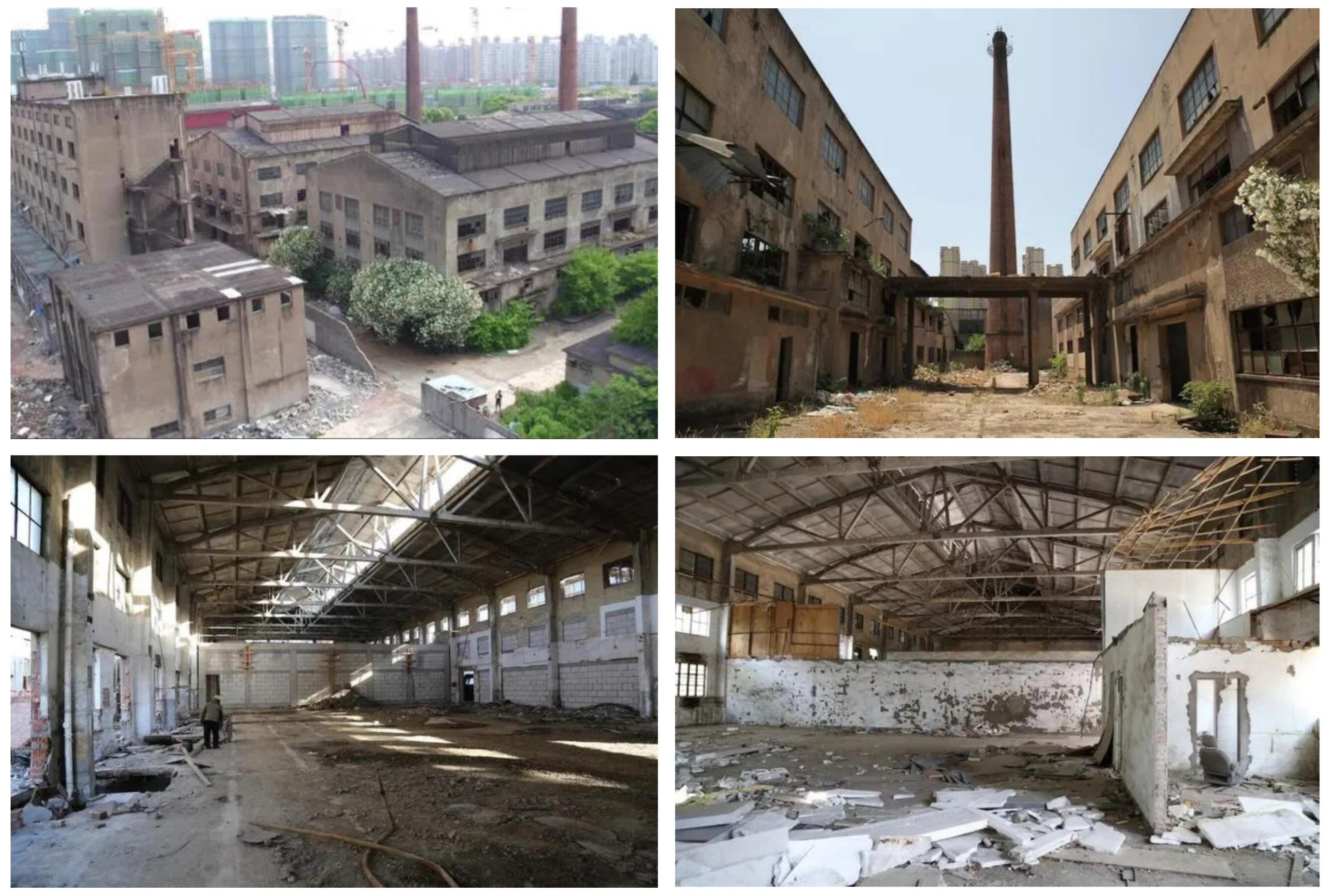
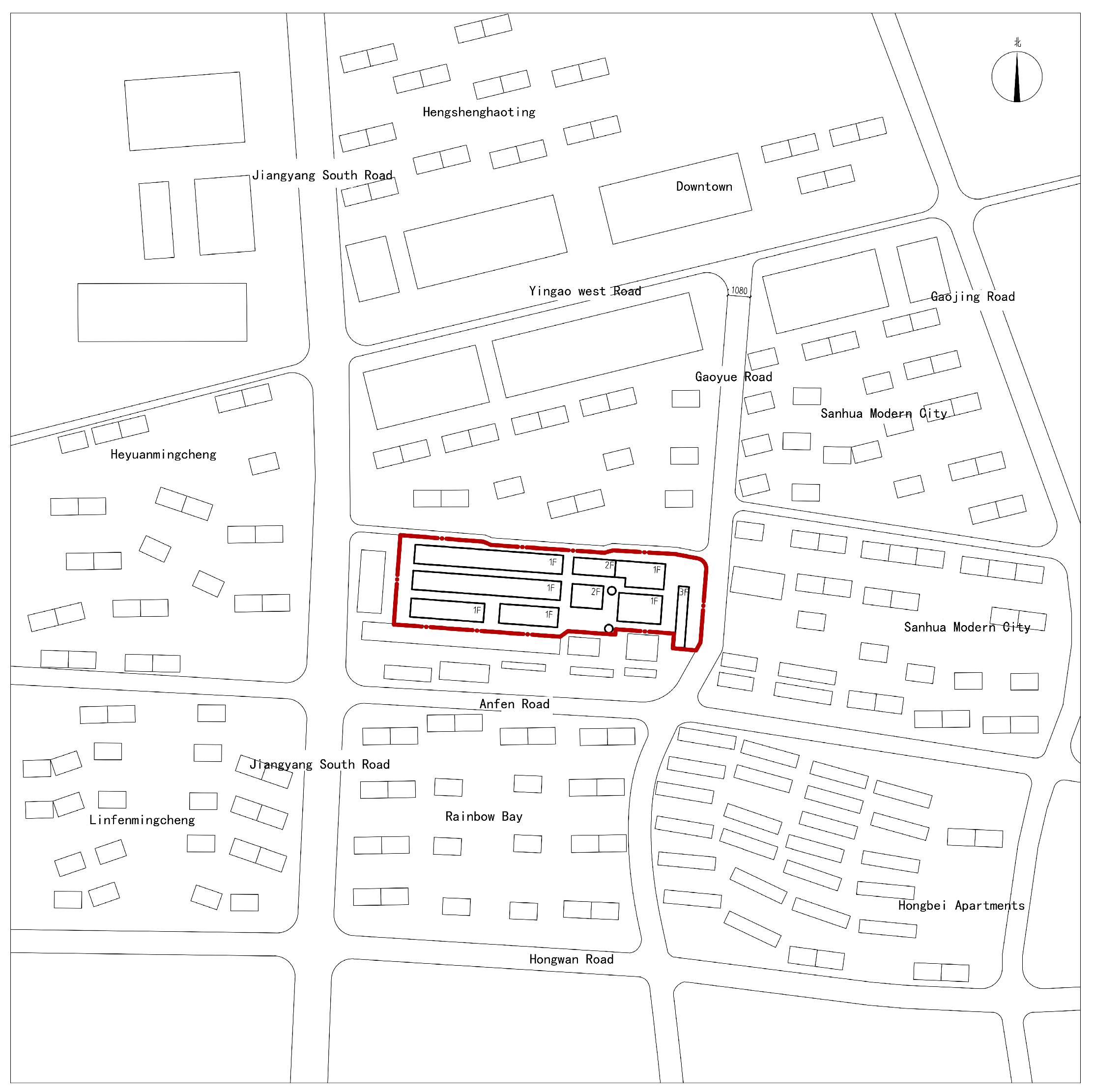
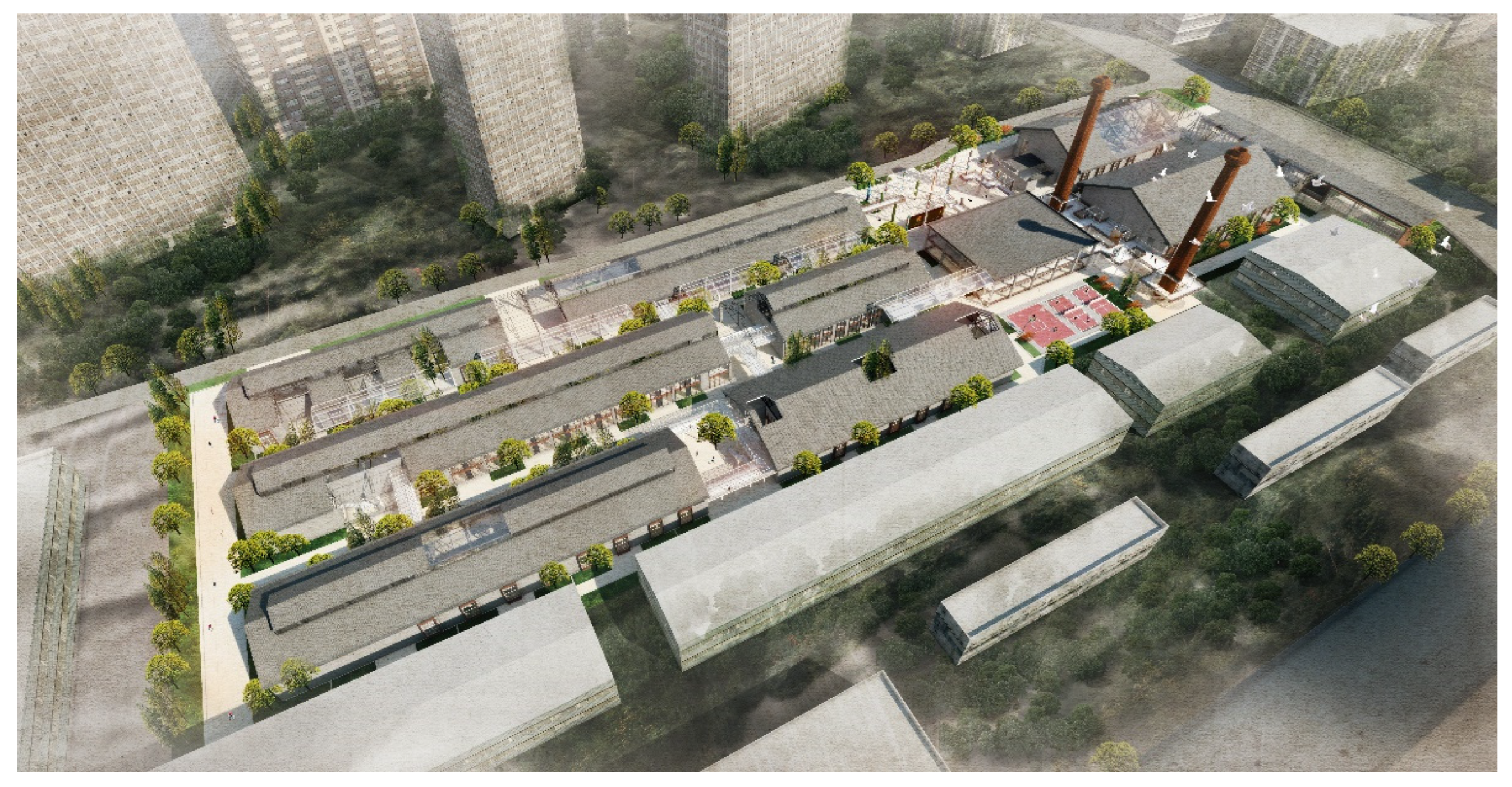
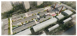
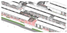
In this study, we have selected a highly representative industrial heritage park in Shanghai, which is considered the largest industrial city in modern China [41]. Specifically, we have chosen the manufacturing park of Shanghai Sanlinqiao Nitro Thermos Guts Factory to analyze the spatial structure issues of the industrial heritage buildings. To achieve this, we have employed the method of social network analysis and proposed a targeted solution strategy. The Sanlinqiao Nitro Thermos Factory boasts a rich history spanning over three decades. However, as time has passed, the once thriving manufacturing park has experienced a gradual decline, resulting in the preservation of only a collection of aging factory buildings (Figure 1 and Figure 2). The vicinity surrounding the park is characterized by a limited availability of land resources and a dearth of public spaces for communal engagement. Consequently, there exists a pressing demand for the establishment of a dynamic and extensively interactive community activity center. The interior space of the Sanlinqiao Insulated Bottle Gallbladder Factory is characterized by its spaciousness and significant social and cultural value. Transforming the area into a community cultural center, cultural exhibition, and recreational complex can effectively utilize the land, boost the liveliness of the region, and simultaneously cater to the public’s demand for cultural activities, entertainment, and recreation.

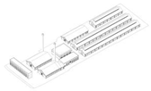
Figure 1.
(top left): Original view of Shanghai Nippon Sanitary Bottle Factory. (top right): Big chimney in the site. (bottom left): Big space without columns and high ceiling. (bottom right): Original view of the interior space of the factory. Source: https://m.thepaper.cn/newsDetail_forward_14466796 (accessed on 10 November 2023).
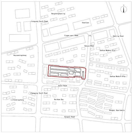
Figure 2.
Project site.
3.2. Status Quo Spatial Network Modelling
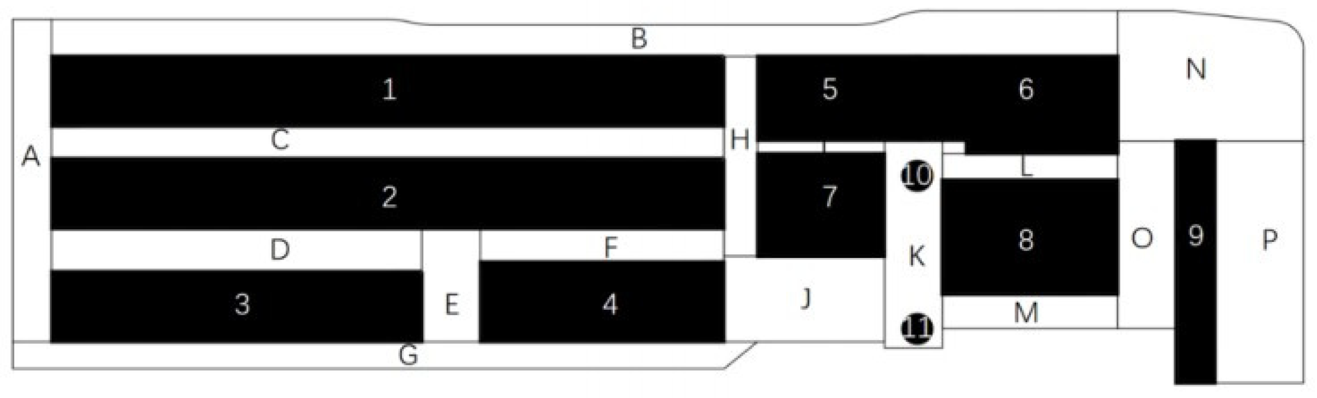
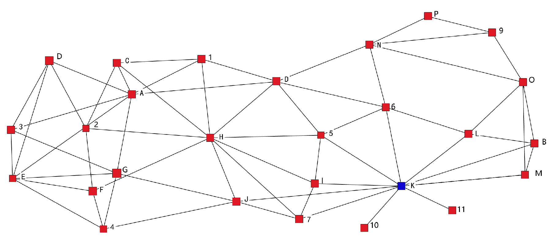
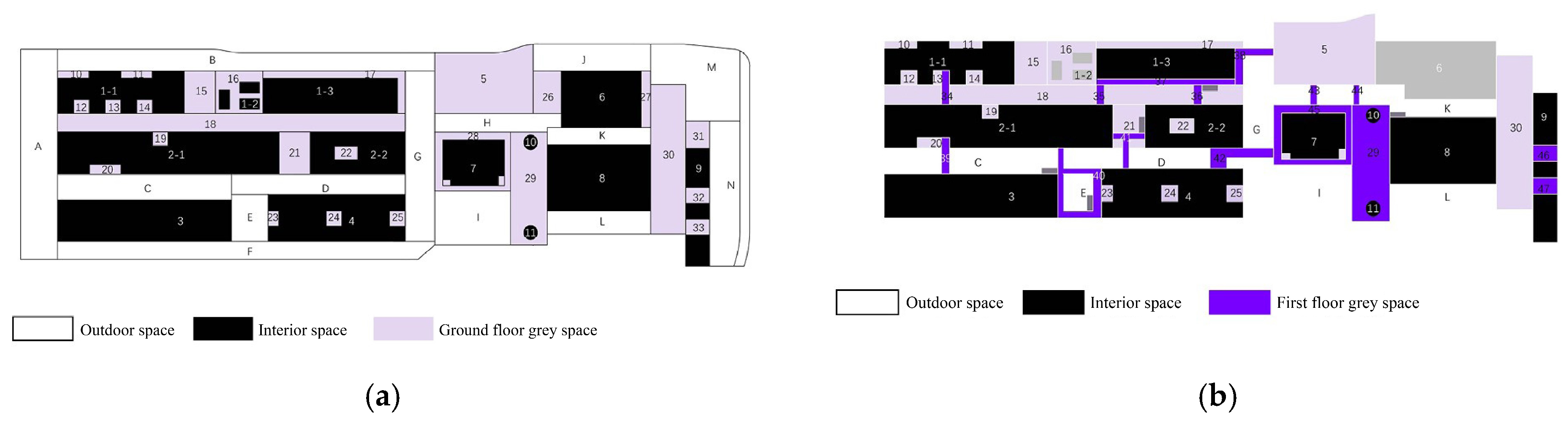
The model construction is divided into two components: building interior space and outdoor space. The building’s interior space is represented by a black color with corresponding node numbers as numbers, while the outdoor space is represented by a white color with corresponding node numbers (Figure 3). The delineation of the outdoor space is determined based on the criteria outlined in the convex space analysis. The convex space is distinguished by the property that every pair of points within the space has unobstructed visibility of one another [42].
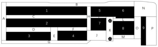
Figure 3.
Current spatial division of the Sanlinqiao.
The spatial configuration of the industrial heritage park is represented as a network model, which captures the relationships between the various functional spaces within the park. Each functional space is treated as a node in the network, and the adjacent and accessible functional spaces are denoted as “1”, while the non-adjacent spaces are denoted as “0”. This information is then organized into a data matrix (Figure 4). The establishment of the current spatial network model of Sanlinqiao Industrial Heritage Park was achieved through the utilization of network analysis software, Ucinet (version 6.759), and graphic software, Netdraw (version 2.161).

Figure 4.
Spatial relationship data matrix for the current state of the Sanlinqiao.
3.3. Analysis of the Status Quo Spatial Network Model
The analysis of the social network was employed to examine the three objective challenges encountered in the conversion of industrial heritage structures into public buildings, with each challenge being assessed using three corresponding indicators.
3.3.1. Cohesion Analysis
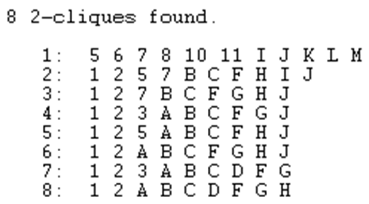
Cohesion analysis involves studying small groups or substructures that may exist in a social network. By utilizing the two-clique calculation in the social network analysis software ucinet, one can identify the factions within the network and derive their interrelationships. Also, we can use the probability that two nodes adjacent to a node are also adjacent to each other using the clustering coefficient to represent the probability that two nodes adjacent to a particular node are also adjacent to each other. The clustering coefficient Ci for a node i in the network with degree ki is defined as:
where Ei is the number of edges that actually exist between the ki neighbors of node i, which is the count of pairs of neighbors that actually exist among the ki neighbors of node i. If a node i has only one neighboring node or no neighboring nodes, i.e., ki = 1 or ki = 0, then Ei = 0. At this time, both the numerator and denominator of the above equation are zero, and we denote it as Ci = 0. Obviously, 0 ≤ Ci ≤ 1, and Ci = 0 if and only if none of the two neighboring nodes of node i are neighbors of each other or if node i has at most one neighboring node.
The average weighted clustering coefficient C of a network is defined as the average of the clustering coefficients of all nodes in the network, i.e.,:
Clearly, there are 0 ≤ C ≤ 1, C = 0 when and only when the clustering coefficients of all the nodes in the network are zero. C = 1 when and only when the clustering coefficients of all the nodes in the network are 1. In this case, the network is globally coupled, i.e., any two nodes in the network are connected.
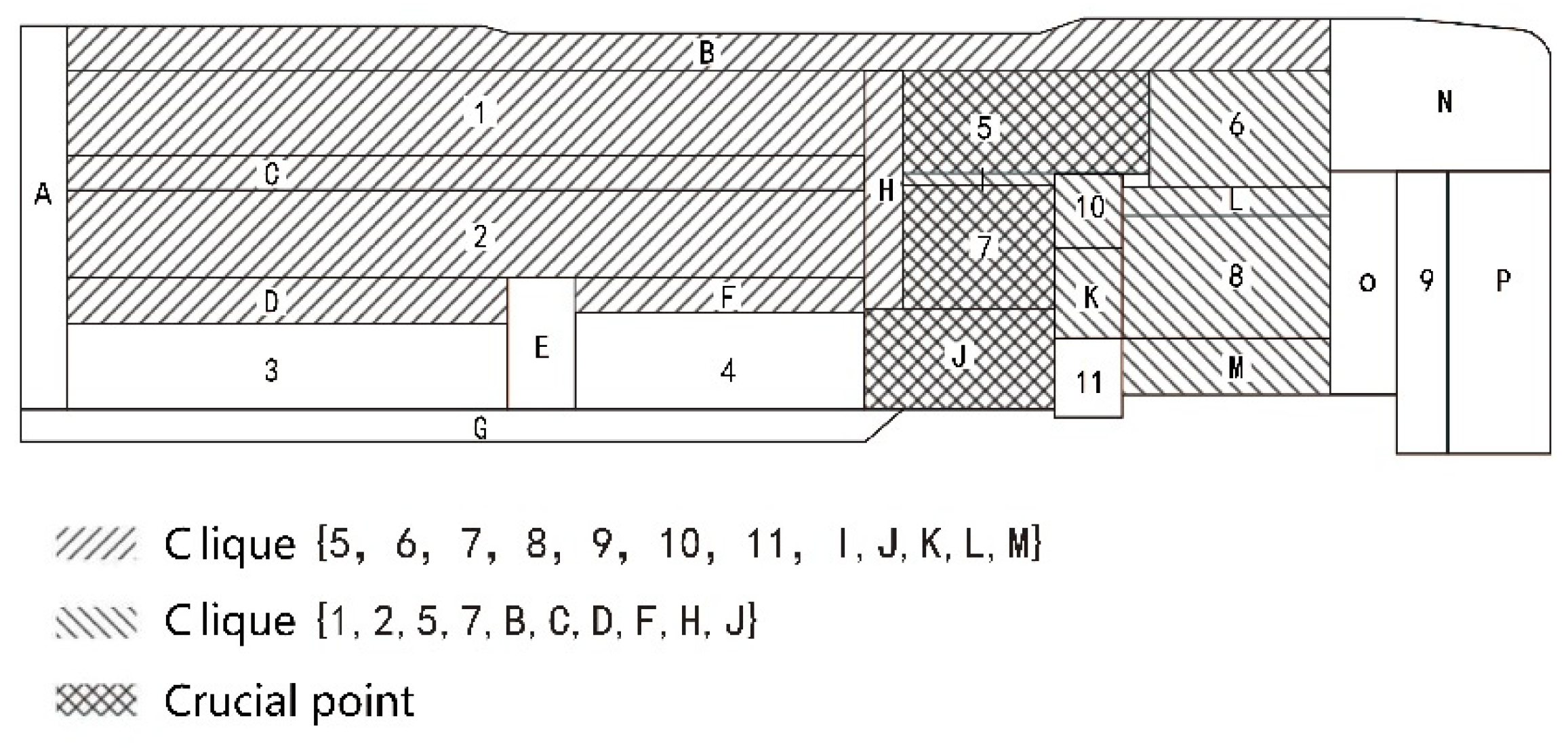
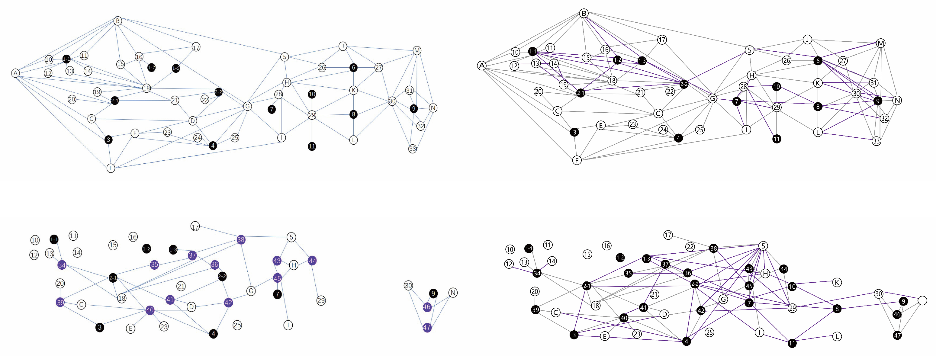
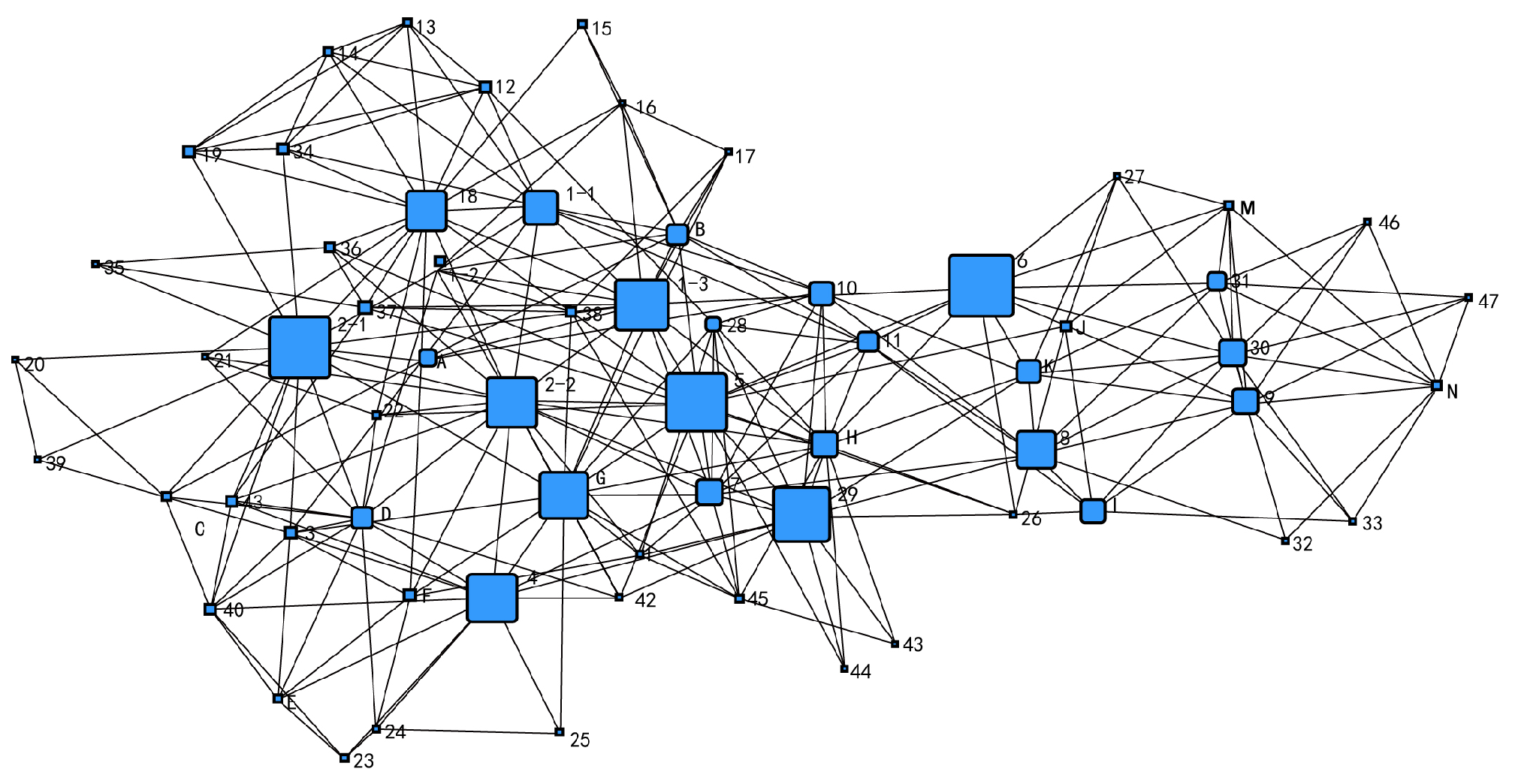
The average weighted clustering coefficient of the existing spatial network is 0.369, indicating a moderate level of local interconnectedness. However, the overall aggregation of the network is not particularly high. Eight factions can be identified through two-clique analysis (Figure 5). Faction 1 exhibits a low degree of overlap with other cliques, allowing for the simplification of the entire network into two factions: the east-side clique {5,6,7,8,10,11, I, J, K, L, M} (hereinafter referred to as the east-side clique) and {1, 2, 5, 7, B, C, D, F, H, J} (hereinafter referred to as the west-side clique) (Figure 6). The six nodes 4, 9, E, N, O, and P do not belong to any clique, while nodes 5, 7, and J serve as important connectors between the two cliques.

Figure 5.
Analysis of two-clique network factions in the current space of Sanlinqiao.
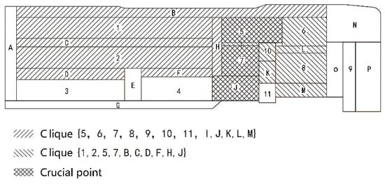
Figure 6.
The current spatial network of Sanlinqiao is divided into cliques.
The main reason for the weak connection between the outdoor space and the building’s internal space is the lack of integration. The outdoor space is only connected to the building through a single plant door, and the exterior walls of the building are solid with few openings. This design does not allow for a seamless visual connection between the indoor and outdoor spaces, resulting in a weak link between the different nodes within the park and a lack of overall cohesion. Some spatial nodes exhibit inadequate connectivity with the entirety, rendering them more isolated and disconnected from the overall network.
3.3.2. Centrality Analysis
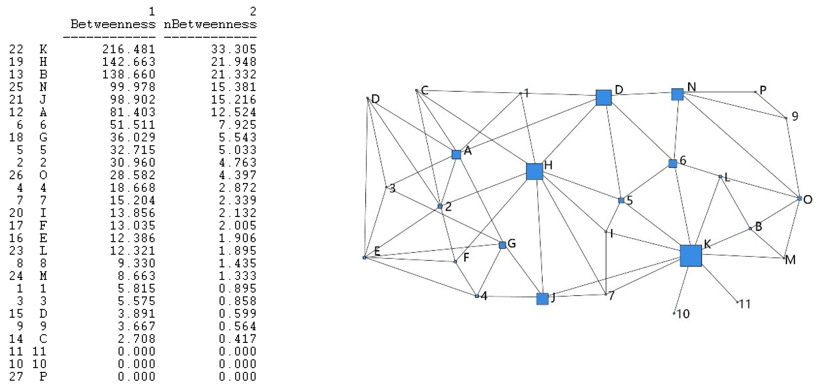
The study of centrality in social network analysis is essentially an abstraction of the concept of “power” in sociology. If power is defined from a network perspective, then an individual existing alone does not possess “power”. Power is only attributed to individuals who establish connections and influence others. The greater the dependence on an individual, the more powerful they are perceived to be. When individuals rely on a specific person, the greater the degree of dependence, the greater the individual’s “power”, and accordingly, the more powerful that individual becomes, positioning them more centrally within the social network. Centrality is divided into three types: degree centrality, intermediate centrality, and near centrality. Among these, intermediate centrality represents the node’s ability to control other nodes in the network, which is more meaningful for reflecting spatial accessibility. Therefore, this paper selects intermediate centrality for analysis.
If an individual is located along the shortest paths (shortcuts) between more other individuals interacting with the node, then the value of intermediary centrality at this point will be higher, and the degree of centrality will also be higher, indicating greater influence within the network. If there are R shortest paths between points x and y, and point z is the third point, Rxy denotes the number of shortest paths between x and y, Rxy(z) denotes the number of shortest paths between points x and y that need to pass through z, and Cxy(z) denotes the probability that point z is located in the middle of the shortest paths between points x and y, i.e., the extent of point z’s influence on interactions with points x and y. Then, the following formula can be derived:
Above is the ability of point z to control a pair of nodes. To determine the overall ability of all points z to control other pairs of interactions, i.e., its intermediate degree of centrality, it is necessary to calculate the sum of the probabilities of all points z lying between the shortest paths of interactions of a certain pair of points S.
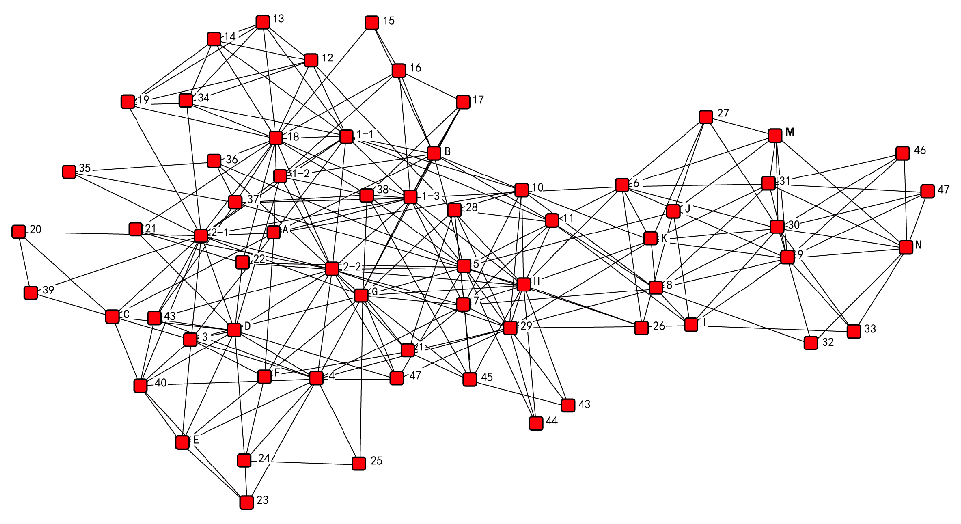
The central spatial nodes in the park network are: K, H, B, N, J, A, 6, G, 5, and 2 (Figure 7). These nodes are located on the shortest path of other nodes, control the interaction of other nodes, occupy more favorable spatial positions, and people will frequently pass through them when traveling, which is important for the spatial layout. Relatively speaking, nodes 11, 10, and P are less centrally located.

Figure 7.
(left): Betweenness centrality values. (right): Betweenness centrality visualization.
The main reasons for this analysis are: outdoor activity space accounts for a large proportion of the factory space and is closely linked, and the location and line of sight between the building space and other spaces in the factory are too loose, resulting in the degree of centrality of the nodes of the outdoor space being significantly higher than that of the nodes of the building space. The general plan of the factory area is a narrow rectangle, some space nodes are on the necessary path to other spaces, and the positional advantages and disadvantages between the internal spaces of the factory area have a large gap, which leads to a large difference in the centrality of each node.
3.3.3. Relevance Analysis
The relevance of social networks is essentially a study of the sociological concept of “solidarity”. The more paths there are from one node to another, the higher the level of connectivity.
A component is also known as a correlation graph. The stronger the connection between pairs of points in the network, the more paths there are, and the greater the degree of correlation of the network. In UCINET, the order of network–cohesion–density can be used to calculate the density of the reachable distance matrix (distance-based cohesion). The range of values is 0 to 1; larger values indicate denser networks and stronger correlations. The formula is as follows:
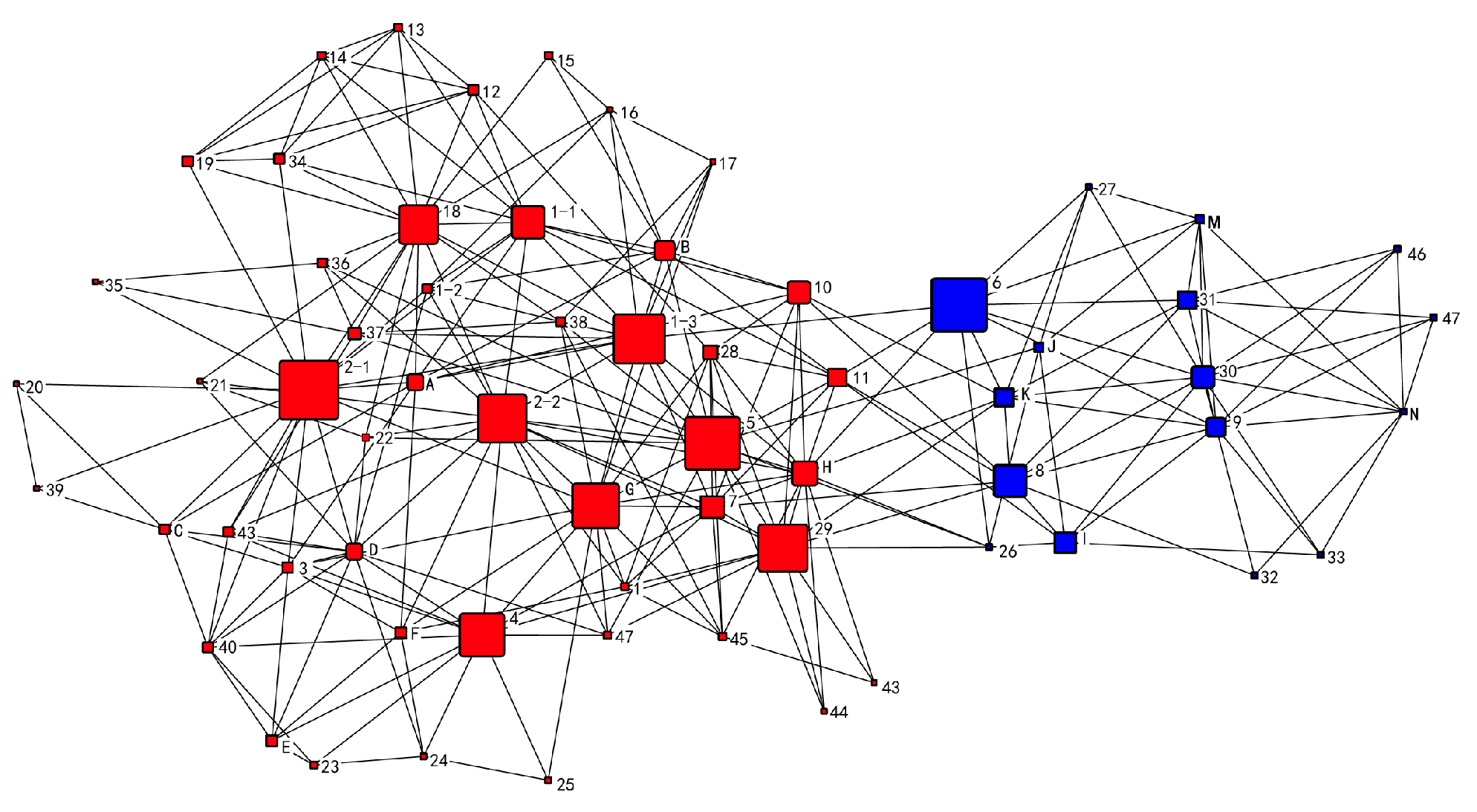
The network demonstrates a correlation coefficient of 0.432, suggesting a significant level of correlation within the network as a whole. After performing calculations, it has been ascertained that a critical point, referred to as K, exists within the spatial network. If node K is eliminated, nodes 10 and 11 will become disconnected from the remaining network (Figure 8). The removal of this element has a significant impact on the vulnerability and independence of nodes 10 and 11, rendering them the most susceptible entities within the entire network. On the contrary, nodes B, H, A, 2, K, and J within the network demonstrate a notable level of connectivity with other nodes, suggesting a robust degree of association and extensive reachability. Meanwhile, the connectivity of the nodes in the outdoor space is significantly higher in comparison to the nodes in the building space. However, nodes 9 and P demonstrate reduced levels of connectivity and are somewhat isolated from the broader network.
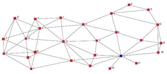
Figure 8.
Analysis of the current spatial network cut-points in the Sanlinqiao.
The analysis of the main reason reveals that the red brick chimneys situated at nodes 10 and 11 are remarkably distinctive structures. However, the limited physical space available for human activities restricts the connectivity between these nodes and the surrounding areas solely to visual observation. As a consequence, there exists a notable susceptibility in relation to the aspects of interaction and engagement. Node 9, referred to as P, is located in a geographically secluded area in the easternmost part of the park, leading to restricted connectivity with the rest of the park. Despite the presence of some spaces that demonstrate a considerable degree of interconnectedness, it is apparent that both outdoor and indoor spaces lack discernible structures and fail to elicit a sense of familiarity, leading to a monotonous spatial encounter.
4. Optimal Adaptation Based on Social Network Analysis
4.1. Retrofit Strategy
Based on the aforementioned analysis of the cohesion, centrality, and relevance of the spatial network within the park, a number of specific issues have been identified in relation to functional zoning, spatial accessibility, and path richness. Consequently, specific spatial renovation strategies are proposed in the subsequent sections, drawing upon the findings of the analysis. The allocation of space adheres to the demands of room utilization and the particular strategies and results (Table 3) are as follows.
Table 3.
Transformation results of the Sanlinqiao Community Center Project.
4.1.1. Proposed Strategies for Retrofitting to Mitigate Functional Zoning Issues
- (1)
- Function Matching
According to the cohesive analysis, the space on the site can be roughly divided into two sub-districts, and the interaction within each sub-district is more frequent. The Sanlinqiao community center has a variety of functions. Based on this, the site is divided into two clusters: one for cultural activities that require a relatively quiet environment and the other for relatively active sports and commercial activities.
According to the analysis of centrality and relevance, it is evident that the degree of centrality and average accessibility of the nodes in the eastern group centered on building space nodes 5 and 6 are higher than those in the western group centered on building space node 2. This suggests that the east group is more conducive to cultural activity spaces that necessitate stronger interaction. Node N, with a higher degree of centrality in the network, a spacious area, and a location at a road intersection, can be considered the main entrance of the site. Nodes 5, 7, and J are the connecting nodes between the two clusters. They can be utilized for theaters and squares, which are more public. Sports activities are more purposeful and can be located in the western cluster, which has a lower degree of centrality and accessibility. Node 1 in the west cluster, with its distinctive long and narrow shape and street frontage, can be utilized for commercial purposes to draw people from the surrounding neighborhood.
4.1.2. Proposed Strategies for Retrofitting to Address Spatial Accessibility Issues
- (1)
- The Creation of Grey Space
To enhance the connectivity between individual buildings, it is recommended to extend the connecting line or establish a direct link. Additionally, incorporating additional floor space into a single-story factory building can improve the overall space utilization rate. Furthermore, the integration of new buildings and structures between existing factory buildings can effectively transform them into a cohesive unit. To enhance the connectivity between buildings on the site, one approach is to increase the grey space, which refers to the overlapping area between individuals. This can be achieved by transforming the indoor space of the building into grey space, such as semi-open courtyards and gable corridors. By creating a connection with the outdoor space and expanding the outdoor space in terms of line-of-sight and spatial relationship, the resulting grey space alters the spatial relationship from adjacency to overlap. This blurs the spatial boundaries between indoors and outdoors, creating a multi-layered spatial experience. Ultimately, this transformation turns the entire Sanlinqiao community into a series of interconnected open squares and passage spaces.
- (2)
- Enhance the connectivity between the peripheral space and the entire plant area.
The primary objective is to enhance the connectivity between the nodes located at the periphery of the building and the rest of the nodes within the network. This will be achieved by improving the centrality and accessibility of the vulnerable building nodes through the establishment of strong connections between the buildings. In order to enhance the functionality of the pedestrian street, space node O is integrated with a glass fiber-reinforced plastic frame roof that extends into space N. This design creates three elevated areas on the first floor, connecting multiple elevated grey spaces that link outdoor space nodes O and P. As a result, the line-of-sight access between nodes N and O is expanded, overlapping with the expanded space. Additionally, this design increases the direct path of communication between nodes O and P. Simultaneously, the incorporation of the roof frame and the strong interconnection among nodes N, O, and P further reinforce the structural integrity of nodes 6, 8, and 9, while also enhancing the linkage between the peripheral area and the entire factory.
4.1.3. Retrofitting Strategies Proposed for Enhancing Path Richness
- (1)
- Creation of Outdoor Spaces
To enhance the interactivity and accessibility of the community activity center, it is proposed to demolish a portion of the current building and convert the indoor space into an outdoor public activity area. Additionally, measures such as increasing the proportion of outdoor public activity space or optimizing the existing outdoor space with high activity levels will be implemented to connect the internal spaces of the site. This will aim to attract residents from the surrounding neighborhoods and increase the overall activity within the site [43].
- (2)
- Enhancing the vibrancy of public spaces
Focusing on enhancing the quality of the current public space surrounding the plant, this study aims to analyze the outdoor space nodes and their distinct characteristics. Based on this analysis, various activities will be implemented to promote the liveliness of the site. Additionally, efforts will be made to transform the previously enclosed spatial configuration into an open space accessible to neighboring blocks. J serves as a crucial intermediary connecting the clusters, and it is planned to undergo a transformation into a sports plaza. The connectivity between nodes k and 10, 11 is enhanced, and the introduction of novel architectural elements on the premises fosters a heightened level of engagement between individuals and the red brick chimney.
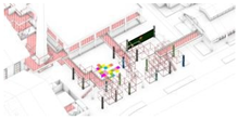
4.2. Modeling of Retrofitted Spatial Networks
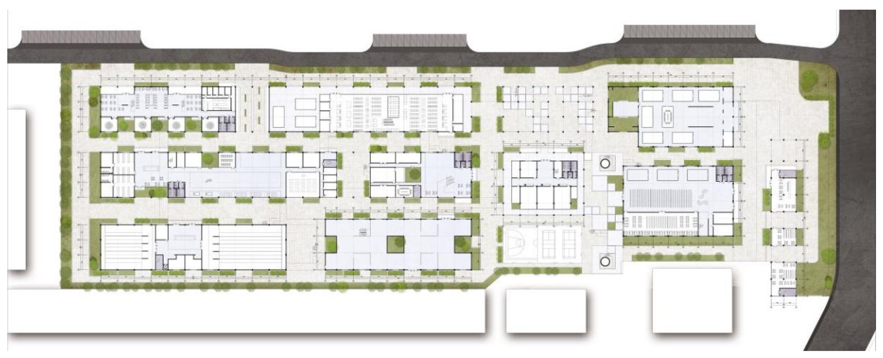
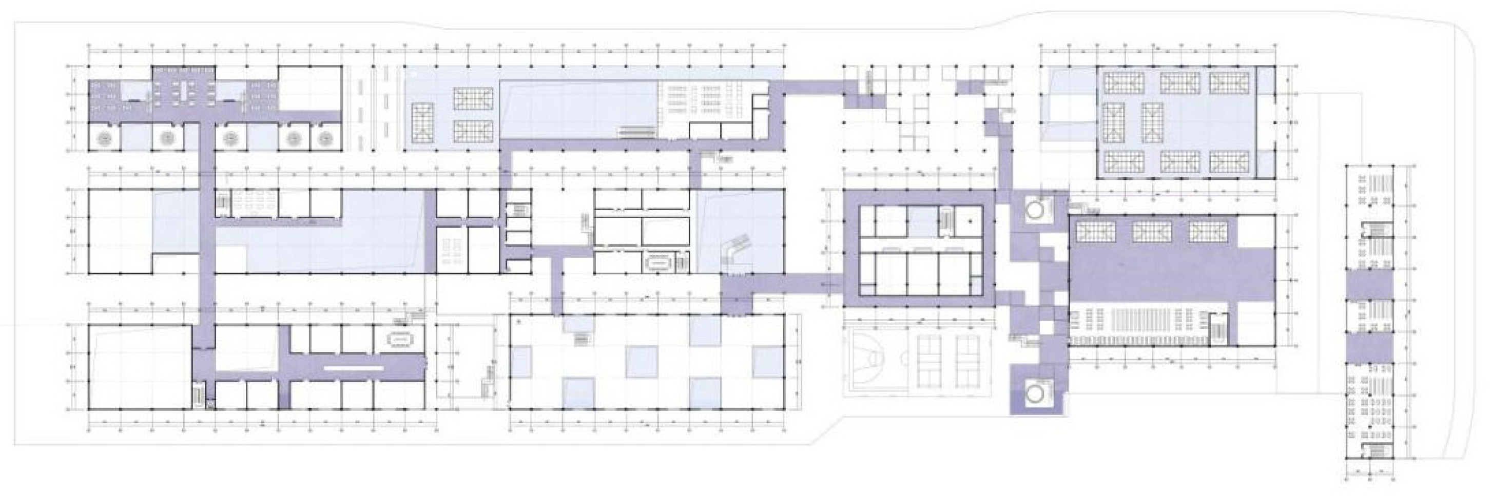
After the renovation, the current state of the Sanlinqiao Community Centre is shown in Figure 9, Figure 10 and Figure 11. Nodal spaces within the network encompass both indoor and outdoor areas, as well as grey spaces. The division of spatial units takes into account the constraints imposed by the number of building floors. Spaces are allocated based on building design methodologies [44,45,46], space area requirements, building design fire codes [47], and human walking patterns within buildings [48] (Figure 12). The principle of connectivity in this study is analogous to the construction of the pre-retrofit network. It is based on the spatial and visual relationships between nodes, where any two nodes in the network that are spatially adjacent and accessible by a visual line of sight or spatially overlapping are considered to have a direct connection (Figure 13).
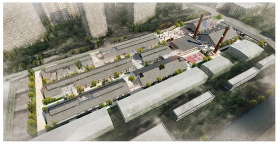
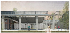
Figure 9.
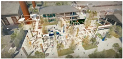
Rendering of the renovated Sanlinqiao Community Center Project.
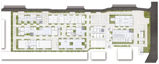
Figure 10.
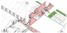
Floor plan of the ground floor of the renovated Sanlinqiao Community Center Project.

Figure 11.
Second floor plan of the renovated Sanlinqiao Community Center Project.

Figure 12.
Spatial division of the renovated Sanlinqiao. (a) First-floor plan space division. (b) Second-floor plan space division.
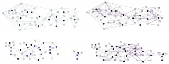
Figure 13.
Spatial relationship of the Sanlinqiao after modification. (top left): Ground floor (nodes are directly linked by proximity and line-of-sight access). (top right): One layer (with spatial overlap between nodes as a direct link). (bottom left): Second level (nodes are directly linked by proximity and line-of-sight access). (bottom right): Second level (with spatial overlap between nodes as a direct link).
4.3. Comparative Analysis of Spatial Network Models before and after Modification
4.3.1. Enhancement of Spatial Network Cohesion
The network clustering coefficients exhibit values of 0.369 and 0.390 before and after the transformation. The network remains a complete set following the transformation, although node K, which serves as the only tangent point in the network, is eliminated. As a result, the overall stability of the network is enhanced. The removal of tangent point K is primarily attributed to the integration of the double-layer interactive plaza at K. This integration effectively merges node K and red-brick towers 10, 11, connecting them with the surrounding architectural space. The objective is to strengthen the significance and accessibility of the vulnerable nodes (10, 11) while simultaneously enhancing the cohesion between nodes K, 10, and 11 (Figure 14).
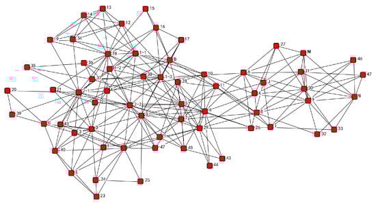
Figure 14.
Analysis of spatial network cut-points in the revamped Sanlinqiao.
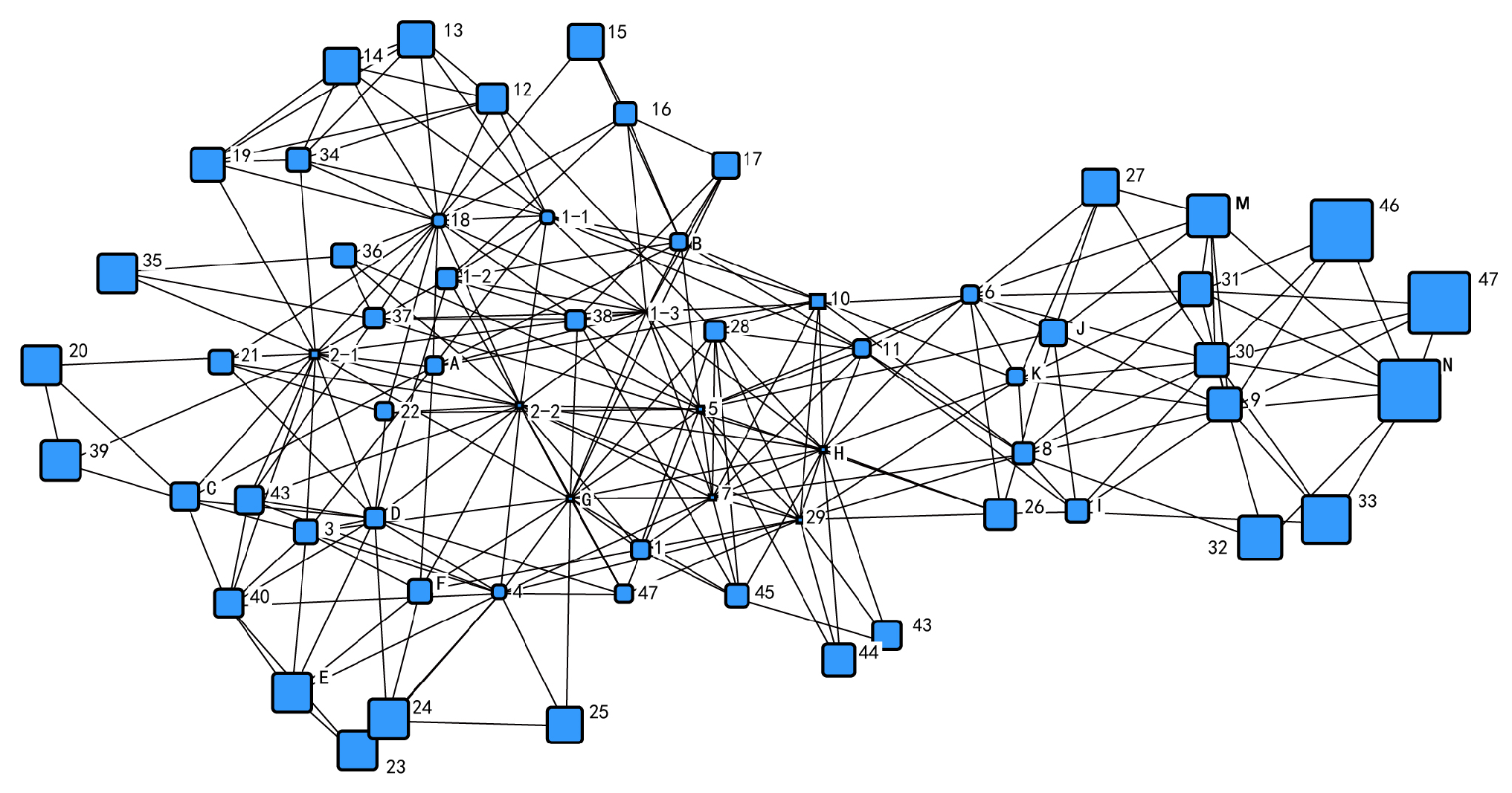
A comprehensive examination of the spatial network indicates the presence of two prominent clusters (Figure 15), accompanied by a rise in the quantity and variety of nodes that serve as intermediaries connecting these clusters.
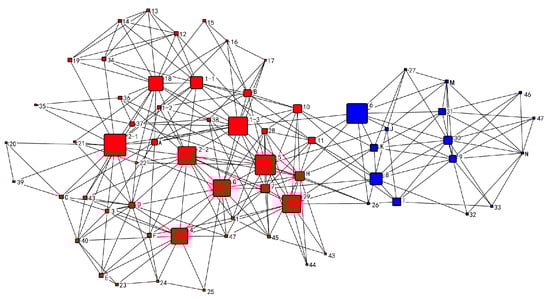
Figure 15.
Analysis of spatial network faction in Sanlinqiao after renovation.
4.3.2. Decreased Disparities in Centrality among Nodes
The average relative intermediate centrality of the entire network experienced a decrease from 6.171% to 2.624% following the transformation of the Sanlinqiao factory. The average relative proximity centrality values are 0.47 and 0.48, respectively. This indicates a difference in the trend of the two centrality indexes. The change can be attributed to an increase in the number of paths between spatial nodes and other nodes in the network, resulting in an overall increase in spatial network complexity. Space-utilizing individuals opt for diverse trajectories at spatial junctions, thereby enabling them to engage in a more intricate, multidimensional, dynamic, and unpredictable spatial encounter. The renovation results in a decrease in the difference in individual centrality, equalization of spatial power, and the emergence of multiple spatial nodes with high and medium centrality and comparable power. This is beneficial for enhancing the overall vitality of the factory area (Figure 16 and Figure 17). Through careful observation and comparative analysis, it becomes evident that the centrality of architectural space nodes is greatly enhanced by the strategic placement of “connecting lines” between various elements, such as buildings and outdoor spaces. This is achieved through the installation of steel frame glass roofs and connecting corridors that link two independent buildings. As a result, the architectural space, which was previously only indirectly connected through the outdoor space, can now be directly interconnected through a multitude of spatial overlapping configurations. This phenomenon facilitates a direct connection between the architectural space and the outdoor space by means of overlapping spaces, which were previously only indirectly connected.
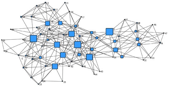
Figure 16.
Spatial network intermediate centrality after Sanlinqiao modification.

Figure 17.
Proximity centrality of spatial network after Sanlinqiao modification.
4.3.3. Increased Relevance of Space Networks
The correlation coefficients of the spatial network before and after the renovation are 0.432 and 0.459, respectively. These values indicate an improvement in the correlation compared to the pre-renovation period. This observation suggests that the overall network exhibits a greater density and a higher level of accessibility. The spatial division within the network of the community activity center becomes more complex, catering to the specific needs of its functions. This complexity leads to an increase in both direct and indirect connections between the various spaces. Upon examining the point connection analysis table of the nodes, it becomes evident that the removal of up to 16 network connections is required in order for the building nodes to lose their interconnections. This suggests a substantial enhancement in the degree of accessibility between the building spaces. Additionally, the average value of the point connections for all nodes has increased, indicating an improvement in the average vulnerability of the network nodes. The elevation of the network increases, resulting in an enhanced average vulnerability of the network nodes.
5. Conclusions and Discussion
This study analyzes and summarizes the current research situation in the field of industrial heritage building reuse. It concludes that in recent years, such research has paid less attention to the rationality of space use and has been unable to form a common space-specific transformation strategy. Taking Shanghai Sanlinqiao Nitro Thermal Insulation Bottle Factory as an example, we utilized the social network analysis method to build the spatial network structure model of the factory, analyze the issues, implement the relevant spatial optimization strategy, and evaluate the transformation outcomes to validate the feasibility of the optimization strategy.
In the context of industrial heritage buildings, the process of transforming an industrial plant into a public building requires the conversion of the existing space into a dynamic and interconnected spatial system [49]. This study employs the social network analysis method, a quantitative research approach—to examine the centrality, cohesion, and relevance of the plant’s space—as well as other relevant indicators. The study also addresses the functional partitioning that occurs during the transformation of an industrial heritage building into a public building. The present study proposes a comprehensive five-point transformation strategy to effectively address three key challenges encountered during the conversion of industrial heritage buildings into public buildings. These challenges include functional zoning, spatial accessibility, and path richness: (1) judge the spaces belonging to the same faction according to cohesive analysis and place the corresponding functions respectively [50]; (2) create grey space [51], increase the overlapping area between building units, thereby enhancing the direct connection between nodes and improving overall spatial accessibility between spaces; (3) improve the connection between edge spaces and the entire plant area [45] and increase the direct connection between edge spaces and other spaces, thus enhancing the overall accessibility of the space system’s accessibility; (4) reasonable expansion of outdoor public activity space [52]: use the external spaces with high activity levels to link various internal spaces within the factory area, thereby increasing the connection between spatial units and providing users with more path choices within the spatial system and increase the number of path choices available to users in the spatial system; (5) stimulate the vitality of the public space to strengthen the interaction between nodes, and increase the different combinations of paths [53]. The spatial system that underwent transformation was reanalyzed using social network analysis, revealing that the optimization had a more pronounced impact. The clustering coefficient of the transformed network exhibits an increase, indicating that the plant spatial network becomes more cohesive. Additionally, the average relative intermediate centrality of the overall network decreases while the average relative proximity to the center increases after the transformation. This suggests that the spatial power of the plant becomes more balanced, and the complexity of the spatial network is heightened. Furthermore, the spatial network correlation is enhanced after the transformation, resulting in a denser network as a whole and increased accessibility of each node. By optimizing the spatial layout design, the issue of uneven space utilization caused by the original building layout is eliminated, and the problem of excessive concentration of pedestrian traffic is significantly alleviated.
Industrial heritage connects the modern world with the productive past, serving as a genuine testament to the advancement of human civilization and a significant milestone in history [54]. As the demand for cultural resources grows, city managers are gradually recognizing industrial heritage buildings in cities as important cultural assets. Conservation and adaptive reuse of industrial heritage buildings extend the service life of existing buildings, encourage the reuse of the energy contained therein, provide significant social and economic benefits to society [55], contribute to the goal of sustainable development, and are effective ways to reduce carbon emissions from the built environment and protect the global climate [56]. This study introduces a novel approach to conceptualizing and exploring methods for renovating industrial heritage and other urban stock spaces. It also holds significant reference value for the adaptive reuse of industrial heritage buildings in different cities. Utilizing social network analysis to develop targeted renovation strategies for adaptive reuse projects of industrial heritage buildings can effectively minimize resource wastage and enhance the controllability of renovation outcomes.
There are still certain limitations in this study that require further enhancement. Specifically, the parameters of the spatial network model of the factory before and after the implementation of the transformation strategy were analyzed and compared using the social network analysis method. In the subsequent phase, we will refine the strategy and assess the changes in the spatial parameters after the adjustment, aiming to identify the most appropriate approach for spatial optimization.
Author Contributions
Conceptualization, J.S., J.C., X.Y. and Y.Z. All authors have read and agreed to the published version of the manuscript.
Funding
This research was funded by the Research on the design methodology of GA-based cluster renewal: Supported by National Natural Science Foundation of China (50608061); and the Impact of Built Environmental Factors in New Village Community on the Residents’ Health: A Perspective from self-rated Health: Supported by NSFC Youth Fund (52008301).
Data Availability Statement
The original contributions presented in the study are included in the article, further inquiries can be directed to the corresponding author.
Conflicts of Interest
The authors declare no conflicts of interest.
References
- Tingting, Z.; Yin, X. Research on Urban Renewal Paths Based on Inventory Space Optimisation. Planner 2013, 29, 36–40. [Google Scholar]
- Fangqiang, Y.; Li, H. The Current Situation of The Reuse of Architectural Transformation of The Old Industrial and Advice. In Proceedings of the International Conference on Energy, Environment and Sustainable Development, Beijing, China, 26–27 June 2014. [Google Scholar]
- Bullen, P.A.; Love, P.E.D. A new model for the past: A model for adaptive reuse decision making. Built Environ. Proj. Asset Manag. 2011, 1, 32–44. [Google Scholar] [CrossRef]
- Bottero, M.; D’Alpaos, C.; Oppio, A. Ranking of Adaptive Reuse Strategies for Abandoned Industrial Heritage in Vulnerable Contexts: A Multiple Criteria Decision Aiding Approach. Sustainability 2019, 11, 785. [Google Scholar] [CrossRef]
- Mısırlısoy, D.; Gunçe, K. Adaptive reuse strategies for heritage buildings: A holistic approach. Sustain. Cities Soc. 2016, 26, 91–98. [Google Scholar] [CrossRef]
- Hao, Z. Test of the main problems in the transformation of industrial buildings in China and its countermeasures. Ind. Build. 2009, 39, 38–40+75. [Google Scholar]
- Jianqiang, W.; Junqiang, R. Adaptive reuse of urban industrial historical buildings and lots. World Archit. 2001, 6, 17–22. [Google Scholar] [CrossRef]
- Oevermann, H.; Degenkolb, J.; Dießler, A.; Karge, S.; Peltz, U. Participation in the Reuse of Industrial Heritage Sites: The Case of Oberschöneweide, Berlin. Int. J. Herit. Stud. 2016, 22, 43–58. [Google Scholar] [CrossRef]
- Martinat, S.; Navratil, J.; Hollander, J.B.; Trojan, J.; Klapka, P.; Klusacek, P.; Kalok, D. Re-reuse of regenerated brownfields: Lessons from an Eastern European post-industrial city. J. Clean. Prod. 2018, 188, 536–545. [Google Scholar] [CrossRef]
- Añibarro, M.V.; Andrade, M.J.; Jiménez-Morales, E. A Multicriteria Approach to Adaptive Reuse of Industrial Heritage: Case Studies of Riverside Power Plants. Land 2023, 12, 314. [Google Scholar] [CrossRef]
- Mesda, Y. Industrial Heritage Buildings in Cyprus: Spatial Experience of the Nicosia Municipal Arts Centre. Prostor 2021, 29, 101–117. [Google Scholar] [CrossRef]
- Vardopoulos, I. Industrial building adaptive reuse for museum. Factors affecting visitors’ perceptions of the sustainable urban development potential. Build. Environ. 2022, 222, 109391. [Google Scholar] [CrossRef]
- Vardopoulos, I. Critical sustainable development factors in the adaptive reuse of urban industrial buildings. A fuzzy DEMATEL approach. Sustain. Cities Soc. 2023, 50, 101684. [Google Scholar] [CrossRef]
- Vardopoulos, I. Adaptive Reuse for Sustainable Development and Land Use: A Multivariate Linear Regression Analysis Estimating Key Determinants of Public Perceptions. Heritage 2023, 6, 809–828. [Google Scholar] [CrossRef]
- Gao, J.; Lin, S.S.; Zhang, C. Authenticity, involvement, and nostalgia: Understanding visitor satisfaction with an adaptive reuse heritage site in urban China. J. Destin. Mark. Manag. 2020, 15, 100404. [Google Scholar] [CrossRef]
- Zheng, X.; Heath, T.; Guo, S. From Maslow to Architectural Spaces: The Assessment of Reusing Old Industrial Buildings. Buildings 2022, 12, 2033. [Google Scholar] [CrossRef]
- Glumac, B.; Islam, N. Housing preferences for adaptive re-use of office and industrial buildings: Demand side. Sustain. Cities Soc. 2020, 62, 102379. [Google Scholar] [CrossRef]
- Ye, Y.; Liu, X. Analysis of the Advantages and Constraints of Old Industrial Buildings. Ind. Build. 2005, 6, 35–38. [Google Scholar]
- Kai, C. New design in the old factory building—Renovation design of the printing factory of the Foreign Research Institute. World Archit. 2000, 10, 87–90. [Google Scholar]
- Zhang, Y.H.; Zhang, L.F. Learning from industrial architecture. World Archit. 2000, 7, 22–23. [Google Scholar] [CrossRef]
- Lin, F. China’s industrial buildings face the challenges of the new century. New Archit. 2004, 3, 4–10. [Google Scholar]
- Jikui, M. Development trend and design countermeasures of large space public buildings. Archit. J. 1996, 3, 36–40. [Google Scholar]
- Kan, Y.; Chen, Z. A preliminary study of space regeneration method for industrial buildings. New Archit. 2012, 2, 10–16. [Google Scholar]
- Shi, K.; Xue, B.; Hu, X. A study on spatial transformation strategy of old industrial buildings under the perspective of structural aesthetics. World Archit. 2013, 4, 4. [Google Scholar]
- Jin, Z.; Liu, B. Community-based transformation of urban industrial heritage. Chin. Foreign Archit. 2008, 1, 144–147. [Google Scholar]
- Ye, C.; Hu, L.; Li, M. Urban green space accessibility changes in a high-density city: A case study of Macau from 2010 to 2015. J. Transp. Geogr. 2018, 66, 106–115. [Google Scholar] [CrossRef]
- Le Texier, M.; Schiel, K.; Caruso, G. The provision of urban green space and its accessibility: Spatial data effects in Brussels. PLoS ONE 2018, 13, e0204684. [Google Scholar] [CrossRef] [PubMed]
- Huang, X. What is the performance of industrial architecture. New Archit. 2004, 3, 15–18. [Google Scholar]
- Lu, D. The Life and Death of Architecture—Research on the Utilization of Historic Buildings; Southeast University Press: Nanjing, China, 2004. [Google Scholar]
- Dong, L.-L.; Wang, W.; Peng, Y.-N. Suitable design strategies for transforming old industrial buildings into crowdsourcing spaces. Ind. Archit. 2019, 49, 31–37+79. [Google Scholar] [CrossRef]
- Watts, D.J. Six Degrees of Separation: Science in an Age of Interconnectedness; Chen, Y., Translator; Renmin University of China Press: Beijing, China, 2011. [Google Scholar]
- Dongquan, L.; Kun, H.; Zhiyong, L. Prospects for the application of social network analysis in planning and management research. Int. Urban Plan. 2011, 26, 86–90. [Google Scholar]
- Huang, Y.; Shi, Y.L. Renewal of Historical and Cultural Township Protection Based on Social Network Analysis—Taking the Case of Yiyan Township in Chongqing. J. Archit. 2017, 2, 86–89. [Google Scholar]
- Zhongmei, G.; Guiqing, Y.; Xiaoxiao, J. Research on the optimisation of spatial network structure of rural settlements based on social network analysis method—Taking X Township in Central Plains Economic Zone as an example. Mod. Urban Res. 2021, 4, 123–130. [Google Scholar]
- Shi, Y.; Huang, Y.; Zhang, R.; Jiang, D.; Zhang, J. Adaptive Renewal of Mountainous Historical Towns Based on the Stability of the Social Network Structure: A Case Study in Chongqing, China. Front. Public Health 2022, 10, 867407. [Google Scholar] [CrossRef]
- Tian, Y.; Kong, X.; Liu, Y.; Wang, H. Restructuring rural settlements based on an analysis of inter-village social connections: A case in Hubei Province, Central China. Habitat Int. 2016, 57, 121–131. [Google Scholar] [CrossRef]
- Song, J.; Abuduwayiti, A.; Gou, Z. The role of subway network in urban spatial structure optimization—Wuhan city as an example. Tunn. Undergr. Space Technol. 2023, 131, 104842. [Google Scholar] [CrossRef]
- Xiaolong, Z.; Yang, Y.; Xun, Z.; Qing, B. A study on urban park transit accessibility based on social network centrality model—Taking Daoli District of Harbin as an example. China Gard. 2019, 35, 49–54. [Google Scholar] [CrossRef]
- Yaling, S.; Huang, Y.; Xiao, L. Optimisation of spatial structure and layout of mountain parks based on social network analysis. China Gard. 2020, 36, 91–96. [Google Scholar] [CrossRef]
- Liu, Z.; Wang, S.; Wang, F. Isolated or integrated? Planning and management of urban renewal for historic areas in Old Beijing city, based on the association network system. Habitat Int. 2019, 93, 102049. [Google Scholar] [CrossRef]
- Sun, M.; Chen, C. Renovation of industrial heritage sites and sustainable urban regeneration in post-industrial Shanghai. J. Urban Aff. 2023, 45, 729–752. [Google Scholar] [CrossRef]
- Borgatti, S.P.; Mehra, A.; Brass, D.J.; Labianca, G. Network Analysis in the Social Sciences. Science 2009, 323, 892–895. [Google Scholar] [CrossRef]
- Hillier, B.; Hanson, J. The Social Logic of Space; Cambridge University Press: Cambridge, UK, 1984; pp. 97–98. [Google Scholar]
- Architectural Design Sourcebook Editorial Committee. Architectural Design Dataset, 3rd ed.; China Construction Industry Press: Beijing, China, 2017. [Google Scholar]
- Peng, Y. Architectural Space Combination Theory; China Architecture Industry Press: Beijing, China, 1999. [Google Scholar]
- Liu, X. Modern Architectural Theory; China Architecture Industry Press: Beijing, China, 1999. [Google Scholar]
- GB 50016-2014; Code for Fire Protection in Building Design. Ministry of Housing and Urban-Rural Development of the People’s Republic of China: Beijing, China, 2014.
- Han, L.-T.; Zhou, L.-J.; Gong, C.; Zhang, A.-G. Indoor navigation network and its generation algorithm considering walking habit. J. Surv. Mapp. 2022, 51, 729–738. [Google Scholar]
- Shi, K.; Xue, B.; Hu, X. Studying in reusing of old industrial buildings’ space in perspective of structure aesthetics. World Arch. 2013, 4, 112–115. [Google Scholar]
- Zhao, W.; Peng, W.; Huang, Y. A Study on the Protection and Renewal of Historical Neighbourhoods Based on Social Network Reconstruction: A Case Study of Sanbukian Historical Neighbourhood in Changshou District, Chongqing. Planner 2008, 2, 9–13. [Google Scholar]
- Kurokawa, K. Kisho Kurokawa’s Urban Design Ideas and Methods; Li, Q., Translator; China Architecture Industry Press: Beijing, China, 2010. [Google Scholar]
- Group theory: Contemporary city-new habitat-architectural design. J. Archit. 2020, Z1, 2–27. [CrossRef]
- Zhang, J.; Lv, J. From large-scale urban design to daily life space. Urban Plan. 2003, 9, 40–45. [Google Scholar]
- Clark, J. Adaptative Reuse of Industrial Heritage: Opportunities & Challenges; Heritage Council of Victoria: Melbourne, VIC, Australia, 2013; 20p. [Google Scholar]
- Yung, E.H.; Chan, E.H. Implementation challenges to the adaptive reuse of heritage buildings: Towards the goals of sustainable, low carbon cities. Habitat Int. 2012, 36, 352–361. [Google Scholar] [CrossRef]
- Conejos, S.; Langston, C.; Smith, J. (Eds.) Improving the Implementation of Adaptive Reuse Strategies for Historic Buildings. In Proceedings of the International Forum of Studies Titled SAVE HERITAGE: Safeguard Architectural, Visual, Environmental, Aversa, Italy, 9–11 June 2011. [Google Scholar]


Disclaimer/Publisher’s Note: The statements, opinions and data contained in all publications are solely those of the individual author(s) and contributor(s) and not of MDPI and/or the editor(s). MDPI and/or the editor(s) disclaim responsibility for any injury to people or property resulting from any ideas, methods, instructions or products referred to in the content. |
© 2024 by the authors. Licensee MDPI, Basel, Switzerland. This article is an open access article distributed under the terms and conditions of the Creative Commons Attribution (CC BY) license (https://creativecommons.org/licenses/by/4.0/).