

Radiocarbon-Refined Archaeological Chronology and the History of Human Activity in the Southern Tarim Basin


Abstract
1. Introduction
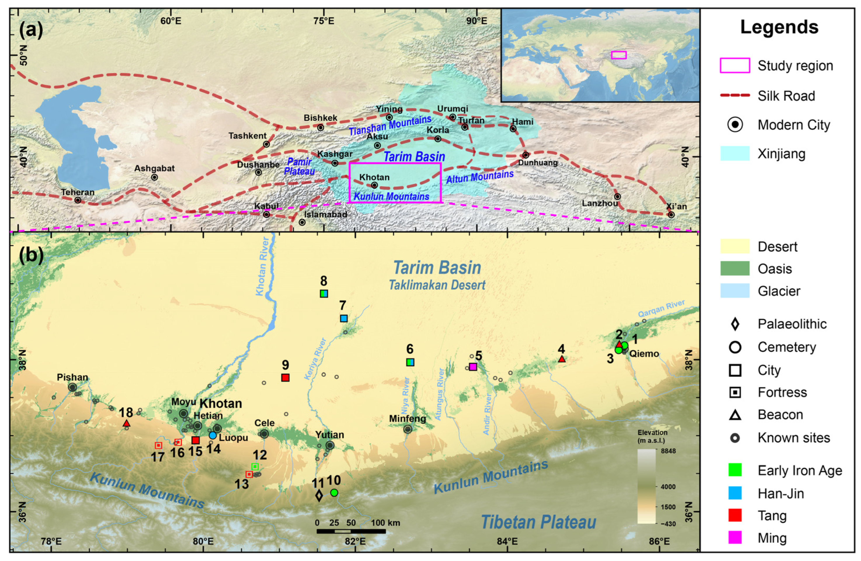
2. Study Area
3. Materials and Methods
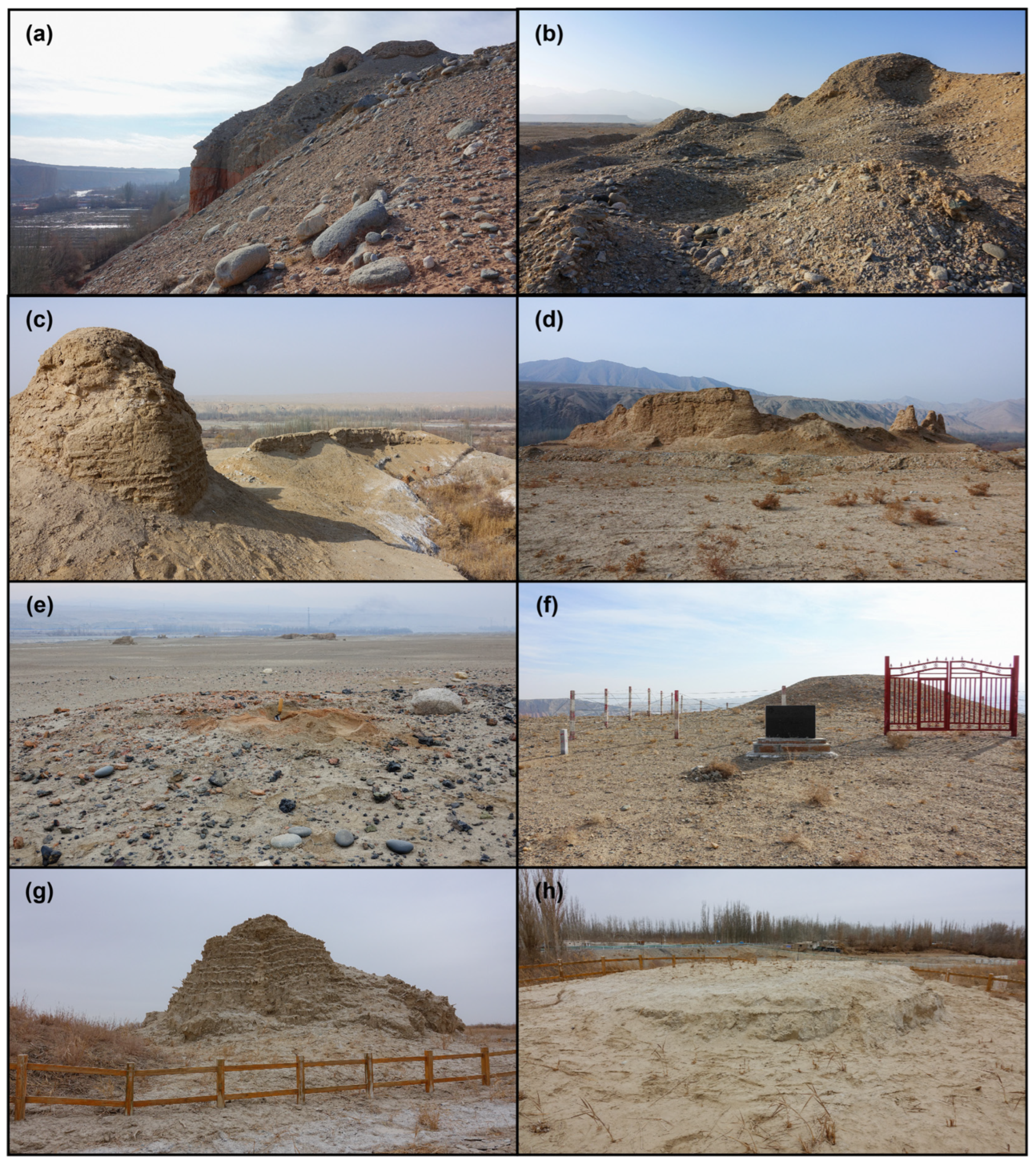
3.1. Field Investigation and Sampling
3.2. Radiocarbon Dating
3.3. Bayesian Chronological Modeling
4. Results and Discussion
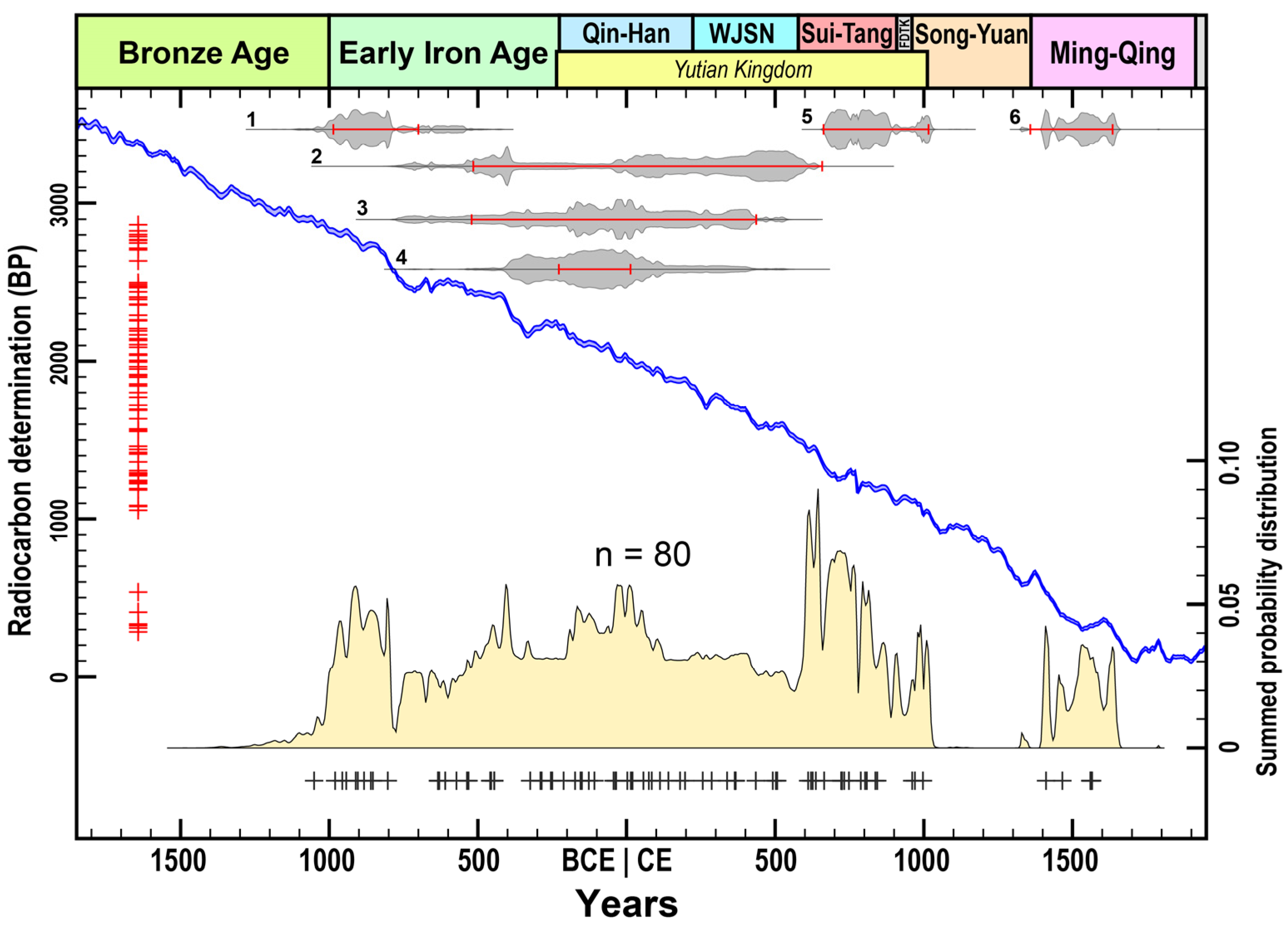
4.1. New Radiocarbon Dates
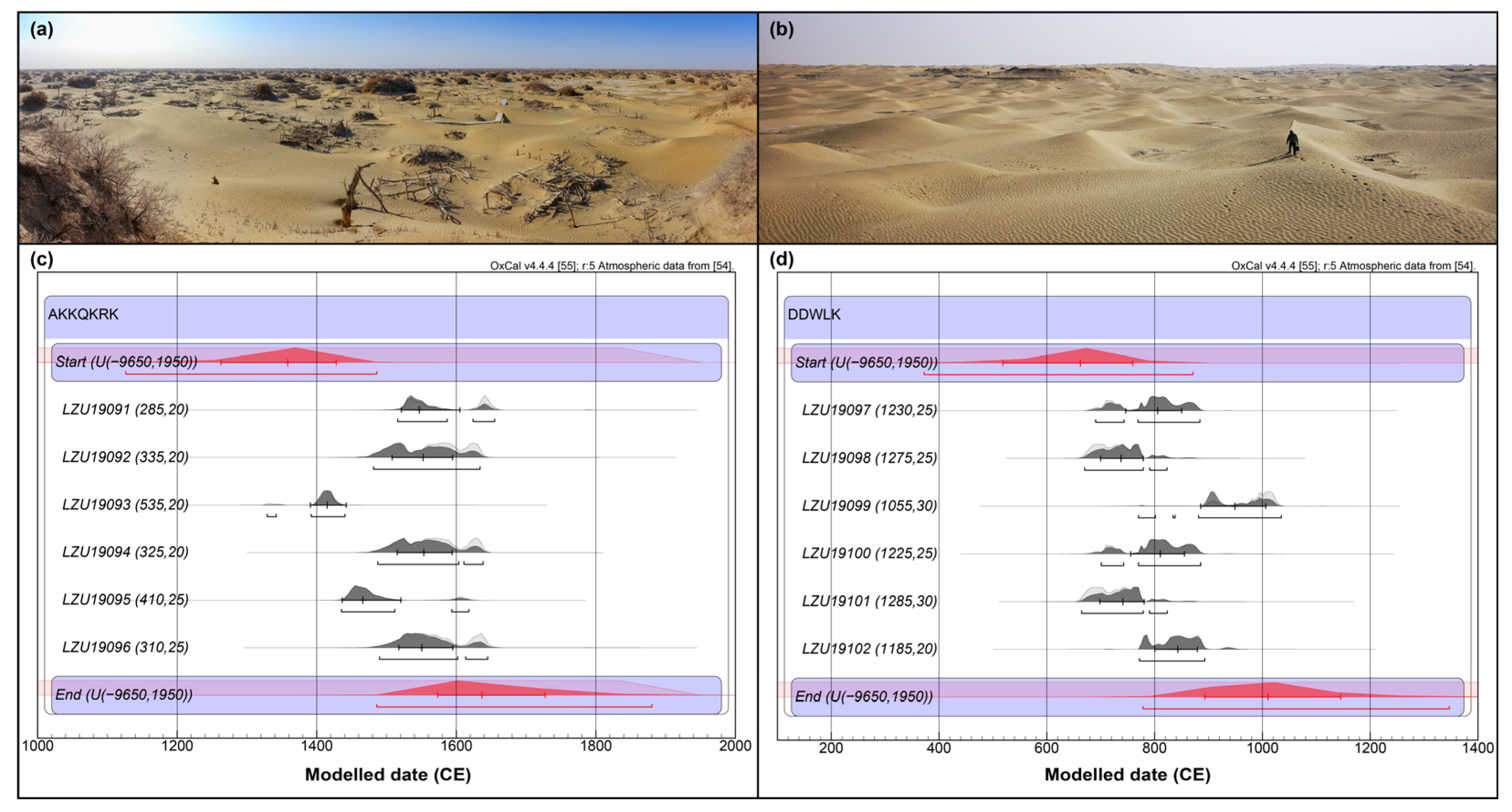
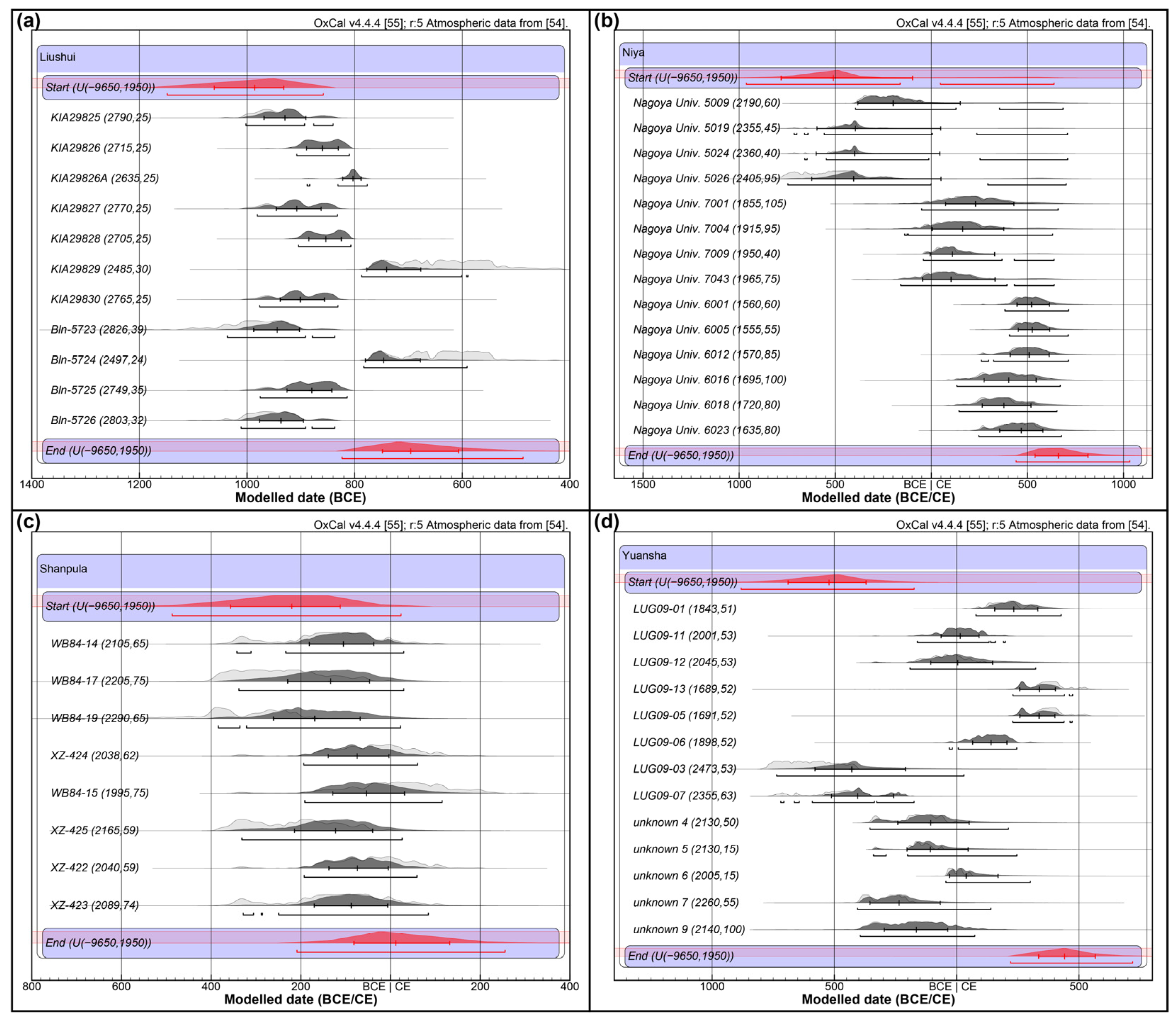
4.2. Refined Chronology of the Archaeological Sites
4.3. A Clearer Local History of Human Activity and Its Implication for Human–Environment Interactions
5. Conclusions
Supplementary Materials
Author Contributions
Funding
Data Availability Statement
Acknowledgments
Conflicts of Interest
References
- Chen, F.H.; Dong, G.H.; Chen, J.H.; Gao, Y.Q.; Huang, W.; Wang, T.; Chen, S.Q.; Hou, J.Z. Climate change and silk road civilization evolution in arid central Asia: Progress and issues. Adv. Earth Sci. 2019, 34, 561–572. (In Chinese) [Google Scholar]
- Dong, G.H.; Liu, F.W.; Chen, F.H. Environmental and technological effects on ancient social evolution at different spatial scales. Sci. China Earth Sci. 2017, 60, 2067–2077. [Google Scholar] [CrossRef]
- Yang, X.; Liu, Z.; Zhang, F.; White, P.D.; Wang, X. Hydrological changes and land degradation in the southern and eastern Tarim Basin, Xinjiang, China. Land Degrad. Develop. 2006, 17, 381–392. [Google Scholar] [CrossRef]
- Qin, X.G.; Liu, J.Q.; Jia, H.J.; Lu, H.Y.; Xia, X.C.; Zhou, L.P.; Mu, G.J.; Xu, Q.H.; Jiao, Y.X. New evidence of agricultural activity and environmental change associated with the ancient Loulan kingdom, China, around 1500 years ago. Holocene 2012, 22, 53–61. [Google Scholar] [CrossRef]
- Mischke, S.; Liu, C.L.; Zhang, J.F.; Zhang, C.J.; Zhang, H.; Jiao, P.C.; Plessen, B. The world’s earliest Aral-Sea type disaster: The decline of the Loulan Kingdom in the Tarim Basin. Sci. Rep. 2017, 7, 43102. [Google Scholar] [CrossRef]
- Huang, X.Z.; Xiang, L.X.; Lei, G.L.; Sun, M.J.; Qiu, M.H.; Storozum, M.; Huang, C.; Munkhbayar, C.; Demberel, O.; Zhang, J.; et al. Sedimentary Pediastrum record of middle–late Holocene temperature change and its impacts on early human culture in the desert-oasis area of northwestern China. Quat. Sci. Rev. 2021, 265, 107054. [Google Scholar] [CrossRef]
- Huang, X.Z.; Chen, C.Z.; Jia, W.N.; An, C.B.; Zhou, A.F.; Zhang, J.W.; Jin, M.; Xia, D.S.; Chen, F.H.; Grimm, E.C. Vegetation and climate history reconstructed from an alpine lake in central Tienshan Mountains since 8.5 ka BP. Palaeogeogr. Palaeoclimatol. Palaeoecol. 2015, 432, 36–48. [Google Scholar] [CrossRef]
- Liu, X.Q.; Herzschuh, U.; Wang, Y.B.; Kuhn, G.; Yu, Z.T. Glacier fluctuations of Muztagh Ata and temperature changes during the late Holocene in westernmost Tibetan Plateau, based on glaciolacustrine sediment records. Geophys. Res. Lett. 2014, 41, 6265–6273. [Google Scholar] [CrossRef]
- Liu, C.L.; Zhang, J.F.; Jiao, P.C.; Mischke, S. The Holocene history of Lop Nur and its palaeoclimate implications. Quat. Sci. Rev. 2016, 148, 163–175. [Google Scholar] [CrossRef]
- Cai, Y.J.; Chiang, J.C.H.; Breitenbach, S.F.M.; Tan, L.C.; Cheng, H.; Edwards, R.L.; An, Z.S. Holocene moisture changes in western China, Central Asia, inferred from stalagmites. Quat. Sci. Rev. 2017, 158, 15–28. [Google Scholar] [CrossRef]
- Chen, F.; Yuan, Y.J.; Trouet, V.; Büntgen, U.; Esper, J.; Chen, F.H.; Yu, S.L.; Shen, M.G.; Zhang, R.B.; Shang, H.M.; et al. Ecological and societal effects of Central Asian streamflow variation over the past eight centuries. npj Clim. Atmos. Sci. 2022, 5, 27. [Google Scholar] [CrossRef]
- Zhang, S.J.; Lu, Y.W.; Wei, W.Y.; Qiu, M.H.; Dong, G.H.; Liu, X.Q. Human activities have altered fire-climate relations in arid Central Asia since ~1000 a BP: Evidence from a 4200-year-old sedimentary archive. Sci. Bull. 2021, 66, 761–764. [Google Scholar] [CrossRef]
- Pan, Y.F.; Mu, G.J.; Gao, C.H.; Behling, H.; Liu, D.X.; Wu, G.Y. Charcoal in Kunlun Mountains loess: Implications for environment change and human activity during the middle Holocene. Front. Earth Sci. 2023, 10, 1030224. [Google Scholar] [CrossRef]
- Spate, M.; Leipe, C.; Motuzaite Matuzeviciute, G. Reviewing the palaeoenvironmental record to better understand long-term human-environment interaction in Inner Asia during the Late Holocene. Front. Ecol. Evol. 2022, 10, 939374. [Google Scholar] [CrossRef]
- Abuduresule, Y.; Liu, G.R.; Li, W.Y. Report on archaeological investigation and excavation at Xiaohe Cemetery in 2002. Res. China. Front. Archaeol. 2005, 3, 337–398. (In Chinese) [Google Scholar]
- Chen, G. The types and chronology of the Cha Wu Hu Gou Kou Culture. Archaeol. Cult. Relics 2001, 5, 30–39. (In Chinese) [Google Scholar]
- Wagner, M.; Wu, X.H.; Tarasov, P.; Aisha, A.; Bronk Ramsey, C.; Schultz, M.; Schmidt-Schultz, T.; Gresky, J. Radiocarbon-dated archaeological record of early first millennium B.C. mounted pastoralists in the Kunlun Mountains, China. Proc. Natl. Acad. Sci. USA 2011, 108, 15733–15738. [Google Scholar] [CrossRef]
- Dodson, J.R.; Li, X.Q.; Zhou, X.Y.; Zhao, K.L.; Sun, N.; Atahan, P. Origin and spread of wheat in China. Quat. Sci. Rev. 2013, 72, 108–111. [Google Scholar] [CrossRef]
- Yang, R.P.; Yang, Y.M.; Li, W.Y.; Abuduresule, Y.; Hu, X.J.; Wang, C.S.; Jiang, H.E. Investigation of cereal remains at the Xiaohe Cemetery in Xinjiang, China. J. Archaeol. Sci. 2014, 49, 42–47. [Google Scholar] [CrossRef]
- Yang, Y.M.; Shevchenko, A.; Knaust, A.; Abuduresule, I.; Li, W.Y.; Hu, X.J.; Wang, C.S.; Shevchenko, A. Proteomics evidence for kefir dairy in Early Bronze Age China. J. Archaeol. Sci. 2014, 45, 178–186. [Google Scholar] [CrossRef]
- Li, Y.Q.; Storozum, M.; Tian, D.; Frachetti, M.; Su, K.; Wang, X. Farming strategies of 1st millennium CE agro-pastoralists on the southern foothills of the Tianshan Mountains: A geoarchaeological and macrobotanical investigation of the Mohuchahangoukou (MGK) site, Xinjiang, China. PLoS ONE 2019, 14, e0217171. [Google Scholar] [CrossRef] [PubMed]
- Zhang, F.; Ning, C.; Scott, A.; Fu, Q.M.; Bjørn, R.; Li, W.Y.; Wei, D.; Wang, W.J.; Fan, L.Y.; Abuduresule, I.; et al. The genomic origins of the Bronze Age Tarim Basin mummies. Nature 2021, 599, 256–261. [Google Scholar] [CrossRef]
- Kumar, V.; Wang, W.J.; Zhang, J.; Wang, Y.Q.; Ruan, Q.R.; Yu, J.J.; Wu, X.H.; Hu, X.J.; Wu, X.H.; Guo, W.; et al. Bronze and Iron Age population movements underlie Xinjiang population history. Science 2022, 376, 62–69. [Google Scholar] [CrossRef] [PubMed]
- Wang, T.T.; Fuller, B.T.; Jiang, H.E.; Li, W.Y.; Wei, D.; Hu, Y.W. Revealing lost secrets about Yingpan Man and the Silk Road. Sci. Rep. 2022, 12, 669. [Google Scholar] [CrossRef] [PubMed]
- Lin, M.C. On the origin hometown of the greater Yuezhi people. West. Reg. Stud. 2013, 2, 90–104. (In Chinese) [Google Scholar]
- Xu, C.N. A Study on the History and Transportation of Lop Nor Region during the Loulan and Shanshan Period. Ph.D. Thesis, Lanzhou University, Lanzhou, China, 2023. (In Chinese). [Google Scholar]
- Yang, Q.J.; Zhou, X.Y.; Spengler, R.N.; Zhao, K.L.; Liu, J.C.; Bao, Y.G.; Jia, P.W.; Li, X.Q. Prehistoric agriculture and social structure in the southwestern Tarim Basin: Multiproxy analyses at Wupaer. Sci. Rep. 2020, 10, 14235. [Google Scholar] [CrossRef]
- Cao, K.; Ma, P.; Qu, M.Y. Archaeological achievements and preliminary understandings from 2021–2022 excavation session at the Aketala site in Shufu county, Xinjiang. West. Reg. Stud. 2023, 2, 125–131. (In Chinese) [Google Scholar]
- Li, K.K.; Qin, X.G.; Xu, B.; Wu, Y.; Mu, G.J.; Wei, D.; Tian, X.H.; Shao, H.Q.; Wang, C.X.; Jia, H.J.; et al. New radiocarbon dating and archaeological evidence reveal the westward migration of prehistoric humans in the drylands of the Asian interior. Holocene 2021, 31, 1555–1570. [Google Scholar] [CrossRef]
- Dang, Z.H.; Li, C.C.; Zhang, X.P.; Xu, Y.C.; Li, Y.; Tian, D.; Zhang, C.R. Early urban occupation in the Tarim Basin: Recent fieldwork results from the fortified site of Kuiyukexiehai’er (Koyuk Shahri). Antiquity 2022, 96, 463–470. [Google Scholar] [CrossRef]
- Hu, X.J.; Alifu; Cai, H.Q.; Yasen, A.; Xu, Y.C.; Su, Y.M.; Kang, X.J. The Kiyakkuduk Beacon Tower of the Tang Dynasty in Yuli County, Xinjiang. Archaeology 2021, 8, 863–884. (In Chinese) [Google Scholar]
- Hu, X.J. An archaeological study on garrison life of Tang Dynasty in Kiyakkuduk Beacon Tower of Yuli County. J. Chin. Nat. Stud. 2023, 4, 118–131. (In Chinese) [Google Scholar]
- Li, Y.Q.; Storozum, M.; Li, H.M.; Hu, D.; Wang, X.; Jia, X. Architectural connections between western Central Asia and China: New investigations at Haermodun (cal AD 90–321), a fortified circular settlement in Xinjiang, China. Antiquity 2021, 95, e10. [Google Scholar] [CrossRef]
- Sheng, P.F.; Zhao, M.Y.; Dang, Z.H.; Allen, E.; Tajie, L.; Ma, T.; Jiang, H.E. Foodways of the Medieval Tibetans on the Silk Road: New evidence from the Miran site in Xinjiang. Holocene 2023, 33, 91–100. [Google Scholar] [CrossRef]
- Zhong, W.; Xue, J.B.; Shu, Q.; Wang, L.G. Climatic change during the last 4000 years in the southern Tarim Basin, Xinjiang, northwest China. J. Quat. Sci. 2007, 22, 659–665. [Google Scholar] [CrossRef]
- Zhang, F.; Wang, T.; Yimiti, H.; Shi, Q.D.; Ruan, Q.R.; Sun, Z.Q.; Li, F. Hydrological changes and settlement migrations in the Keriya River delta in central Tarim Basin ca. 2.7–1.6 ka BP: Inferred from 14C and OSL chronology. Sci. China Earth Sci. 2011, 41, 1495–1504. (In Chinese) [Google Scholar] [CrossRef]
- Dong, G.H.; Li, T.; Zhang, S.J.; Ren, L.L.; Li, R.; Li, G.Q.; Xiao, Y.M.; Wang, Z.X.; Chen, F.H. Precipitation in surrounding mountains instead of lowlands facilitated the prosperity of ancient civilizations in the eastern Qaidam Basin of the Tibetan Plateau. Catena 2021, 203, 105318. [Google Scholar] [CrossRef]
- National Cultural Heritage Administration. An Atlas of Chinese Cultural Relics: Fascicule of Xinjiang Uygur Autonomous Region; Cultural Relics Press: Beijing, China, 2012. (In Chinese) [Google Scholar]
- Xinjiang Uygur Autonomous Region Bureau of Cultural Heritage. Integration of the Results of the Third National Survey of Cultural Relics in Xinjiang: Volume of Hetian Region; Science Press: Beijing, China, 2011. (In Chinese) [Google Scholar]
- Cao, H.H.; Wang, Y.Q.; Qiu, M.H.; Shi, Z.L.; Dong, G.H. On the exploration of social development during a historical period in the Eastern Tianshan Mountains via archaeological and geopolitical perspectives. Land 2022, 11, 1416. [Google Scholar] [CrossRef]
- Tan, B.; Wang, H.W.; Wang, X.Q.; Yi, S.Y.; Zhou, J.; Ma, C.; Dai, X.Y. The study of early human settlement preference and settlement prediction in Xinjiang, China. Sci. Rep. 2022, 12, 5072. [Google Scholar] [CrossRef]
- Tan, B.; Wang, H.W.; Wang, X.Q.; Yi, S.Y.; Zhou, J.; Ma, C.; Dai, X.Y. Spatial distribution data of cultural sites from the Paleolithic to Bronze Age in Xinjiang, China. Sci. Data 2022, 9, 205. [Google Scholar] [CrossRef]
- Ding, G.Q.; Chen, J.H.; Lei, Y.B.; Lv, F.Y.; Ma, R.; Chen, S.Q.; Ma, S.; Sun, Y.H.; Li, Y.C.; Wang, H.P.; et al. Precipitation variations in arid central Asia over past 2500 years: Possible effects of climate change on development of Silk Road civilization. Global Planet. Chang. 2023, 226, 104142. [Google Scholar] [CrossRef]
- Han, W.X.; Yu, L.P.; Lai, Z.P.; Madsen, D.; Yang, S.L. The earliest well-dated archeological site in the hyper-arid Tarim Basin and its implications for prehistoric human migration and climatic change. Quat. Res. 2014, 82, 66–72. [Google Scholar] [CrossRef]
- Wang, B.; Lu, L.P.; Xu, H.H.; Aishan, A.; Maimaiti, Y. Excavation of graveyard No.1 at Zagunluk in Charchan, Xinjiang. Acta Archaeol. Sin. 2003, 1, 89–136. (In Chinese) [Google Scholar]
- Gong, G.Q.; Qin, D.H. Excavation of the Jiawaairike Cemetery in Qiemo County, Xinjiang. Archaeology 1997, 8, 789–800. (In Chinese) [Google Scholar]
- Abuduresule, Y.; Frankfurt, G.D.; Liu, G.R.; Zhang, Y.Z. An overview of the archaeological investigation of the Keriya River Basin in Xinjiang. Archaeology 1998, 12, 1084–1093. (In Chinese) [Google Scholar]
- Yonenobu, H.; Itoh, T. 14C dating of the Niya site in the Tarim Basin. Nucl. Instr. Meth. Phys. Res. B 2000, 172, 741–744. [Google Scholar] [CrossRef]
- Xinjiang Uygur Autonomous Region Museum; Xinjiang Institute of Archaeology. Sampula in Xinjiang of China: Revelation and Study of Ancient Khotan Civilization; Xinjiang People’s Publishing House: Urumqi, China, 2001. (In Chinese) [Google Scholar]
- Schiffer, M.B. Radiocarbon dating and the “old wood” problem: The case of the Hohokam chronology. J. Archaeol. Sci. 1986, 13, 13–30. [Google Scholar] [CrossRef]
- Dong, G.H.; Wang, Z.L.; Ren, L.L.; Motuzaite Matuzeviciute, G.; Wang, H.; Ren, X.Y.; Chen, F.H. A comparative study of 14C dating on charcoal and charred seeds from Late Neolithic and Bronze Age sites in Gansu and Qinghai Provinces, NW China. Radiocarbon 2014, 56, 157–163. [Google Scholar] [CrossRef] [PubMed]
- Cao, H.H.; Wang, Z.L.; He, J.H.; Guo, J.L.; Jull, A.J.T.; Zhou, A.F.; Dong, G.H.; Chen, F.H. Performance and inter-comparison tests of the MICADAS at the radiocarbon laboratory of Lanzhou University, China. Radiocarbon 2023, 65, 41–50. [Google Scholar] [CrossRef]
- Bronk Ramsey, C. Bayesian analysis of radiocarbon dates. Radiocarbon 2009, 51, 337–360. [Google Scholar] [CrossRef]
- Reimer, P.J.; Austin, W.E.N.; Bard, E.; Bayliss, A.; Blackwell, P.G.; Bronk Ramsey, C.; Butzin, M.; Cheng, H.; Edwards, R.L.; Friedrich, M.; et al. The IntCal20 Northern Hemisphere radiocarbon age calibration curve (0–55 cal kBP). Radiocarbon 2020, 62, 725–757. [Google Scholar] [CrossRef]
- Bronk Ramsey, C. OxCal Version 4.4.4. 2021. Available online: https://c14.arch.ox.ac.uk/oxcal.html (accessed on 16 January 2024).
- Shennan, S.; Kevan, E. Prehistoric population history: From the Late Glacial to the Late Neolithic in Central and Northern Europe. J. Archaeol. Sci. 2007, 34, 1339–1345. [Google Scholar] [CrossRef]
- Shennan, S.; Downey, S.S.; Timpson, A.; Edinborough, K.; Colledge, S.; Kerig, T.; Manning, K.; Thomas, M.G. Regional population collapse followed initial agriculture booms in mid-Holocene Europe. Nat. Comm. 2013, 4, 2486. [Google Scholar] [CrossRef]
- Wang, C.; Lu, H.Y.; Zhang, J.P.; Gu, Z.Y.; He, K.Y. Prehistoric demographic fluctuations in China inferred from radiocarbon data and their linage with climate change over the past 50,000 years. Quat. Sci. Rev. 2014, 98, 45–59. [Google Scholar] [CrossRef]
- Dong, G.H.; Li, R.; Lu, M.X.; Zhang, D.J.; James, N. Evolution of human-environmental interactions in China from the Late Palaeolithic to the Bronze Age. Prog. Phys. Geogr. 2020, 44, 233–250. [Google Scholar] [CrossRef]
- Long, T.W.; Taylor, D. A revised chronology for the archaeology of the lower Yangtze, China, based on Bayesian statistical modelling. J. Archaeol. Sci. 2015, 63, 115–121. [Google Scholar] [CrossRef]
- Long, T.W.; Wagner, M.; Tarasov, P.E. A Bayesian analysis of radiocarbon dates from prehistoric sites in the Haidai Region, East China, for evaluation of the archaeological chronology. J. Archaeol. Sci. Rep. 2017, 12, 81–90. [Google Scholar] [CrossRef]
- Yang, Y.S.; Zhang, S.J.; Oldknow, C.; Qiu, M.H.; Chen, T.T.; Li, H.M.; Cui, Y.F.; Ren, L.L.; Chen, G.K.; Wang, H.; et al. Refined chronology of prehistoric cultures and its implication for re-evaluating human-environment relations in the Hexi Corridor, northwest China. Sci. China Earth Sci. 2019, 62, 1578–1590. [Google Scholar] [CrossRef]
- Qiu, M.H.; Liu, R.L.; Li, X.Y.; Du, L.Y.; Ruan, Q.R.; Pollard, A.M.; Zhang, S.J.; Yuan, X.; Liu, F.W.; Li, G.; et al. Earliest systematic coal exploitation for fuel extended to ~3600 B.P. Sci. Adv. 2023, 9, eadh0549. [Google Scholar] [CrossRef]
- Xinjiang Institute of Cultural Relics and Archaeology, China; Academic Research Institute of Niya Site, Bukkyo University, Japan. Dandanwulike: Research Report of the Sino-Japan Joint Investigation; Cultural Relics Press: Beijing, China, 2009. (In Chinese) [Google Scholar]
- Miao, P. A Study History of Archaeology in Dandan Oilik. Master Thesis, Lanzhou University, Lanzhou, China, 2017. (In Chinese). [Google Scholar]
- Zhang, G.D.; Rong, X.J. Investigation of the Historical Documentations of the Ancient Yutian Kingdom; Shanghai Bookstore: Shanghai, China, 1993. (In Chinese) [Google Scholar]
- He, T.W. The unexcavated Asa ancient castle. China Bord. Hist. Geogr. Stud. 1993, 1, 10–12. (In Chinese) [Google Scholar]
- Xi, T.Y. Research on Bronze–Early Iron Age Settlements in Eastern Tianshan Mountains. Ph.D. Thesis, Northwest University, Xi’an, China, 2014. (In Chinese). [Google Scholar]
- Wu, X.H.; Ma, S.; Ailijiang. Brief report of the Bronze Age Liushui Cemetery in Yutian County, Xinjiang. Archaeology 2016, 12, 1339–1356. (In Chinese) [Google Scholar]
- Wu, X.H. A sketch of the excavation and cultural characteristics of the Bronze Age Liushui Cemetery in Yutian County, Xinjiang. Xinjiang Art 2020, 2, 10–24. (In Chinese) [Google Scholar]
- Nie, Z.Z.; Wang, M.H.; Zhang, X.; Wu, X.H.; Zhu, H. A research on craniometric variation of ancient skulls from the Liushui Cemetery. Res. China Front. Archaeol. 2019, 26, 265–278. (In Chinese) [Google Scholar]
- Ruan, Q.R. On exploring the settlement pattern of the Niya site. West. Reg. Stud. 1999, 2, 48–57. (In Chinese) [Google Scholar]
- Yu, Z.Y. Excavation of tome coded M8 of cemetery 95MNI at the Niya site in Xinjiang. Cult. Relics 2000, 1, 4–40. (In Chinese) [Google Scholar]
- Zhang, T.N. Excavation and study on the Buddhist courtyard in Niya site. West. Reg. Stud. 2000, 1, 47–53. (In Chinese) [Google Scholar]
- Ye, J.S. Further discussion on the abandonment of Niya Oasis. Reg. Cult. Stud. 2019, 14, 77–83. (In Chinese) [Google Scholar]
- Li, H.Q.; Li, H.L. Analysis on reasons for abandon of Niya Ruins. J. Chin. Cult. 2021, 2, 144–149. (In Chinese) [Google Scholar]
- Maitituerdi, M. The kingdom engulfed by sands: Discussing the rise and fall of the Jingjue Kingdom during Han-Jin period. Xinjiang Local Rec. 2023, 4, 32–39. (In Chinese) [Google Scholar]
- Li, B.C. On the desertification of Lower Reach of Keliya River ancient oases in Tarim Basin. China Bord. Hist. Geogr. Stud. 2020, 30, 106–118. (In Chinese) [Google Scholar]
- Høisæter, T.L. Polities and nomads: The emergence of the Silk Road exchange in the Tarim Basin region during late prehistory (2000–400 BCE). Bull. SOAS 2017, 80, 339–363. [Google Scholar] [CrossRef][Green Version]
- Xu, B.; Gu, Z.Y.; Qin, X.G.; Wu, Y.; Mu, G.J.; Jiao, Y.X.; Zhang, L.; Hao, Q.Z.; Wang, L.; Wei, D.; et al. Radiocarbon dating the ancient city of Loulan. Radiocarbon 2017, 59, 1215–1226. [Google Scholar] [CrossRef]
- Xia, Q.Q.; Zhang, F. AMS 14C dating and related historical geography question proposal at the Yuansha Delta in the central Taklamakan Desert. Quat. Sci. 2016, 36, 1280–1292. (In Chinese) [Google Scholar]
- Xu, D.K.; Li, C.; Jin, Y.Y.; Deng, Z.H.; Xu, B.; Li, K.K.; Zhang, J.P.; Sun, X.H.; Feng, J.; Jiao, Y.X.; et al. Relationship between the rise and fall of Loulan ancient city and centennial-scale climate events and cycles. Front. Earth Sci. 2023, 17, 1070–1080. [Google Scholar] [CrossRef]


| Site Name | Site Type | Material Dated | Lab Code | 14C Age (BP) | Uncertainty (Year) | Calibrated Age 2σ |
|---|---|---|---|---|---|---|
| AKKQKRK | City | Branch | LZU19091 | 285 | 20 | 1520–1660 CE |
| Branch | LZU19092 | 335 | 20 | 1480–1640 CE | ||
| Charcoal | LZU19093 | 535 | 20 | 1320–1440 CE | ||
| Branch | LZU19094 | 325 | 20 | 1490–1640 CE | ||
| Charcoal | LZU19095 | 410 | 25 | 1430–1620 CE | ||
| Branch | LZU19096 | 310 | 25 | 1490–1650 CE | ||
| Aqike | Fortress | Straw | LZU19112 | 1420 | 25 | 590–660 CE |
| Branch | LZU19113 | 1410 | 20 | 600–660 CE | ||
| Asa | Fortress | Wood | LZU19103 | 1285 | 25 | 660–780 CE |
| Wood | LZU19104 | 1305 | 25 | 650–780 CE | ||
| Axi | Fortress | Wood | LZU19105 | 2465 | 25 | 760–420 BCE |
| Branch | LZU19106 | 2390 | 25 | 550–390 BCE | ||
| Bugunluke | Beacon | Wood | LZU19089 | 1245 | 25 | 670–880 CE |
| Wood | LZU19090 | 1240 | 20 | 680–880 CE | ||
| DDWLK | City | Reed | LZU19097 | 1230 | 25 | 680–890 CE |
| Reed | LZU19098 | 1275 | 25 | 660–820 CE | ||
| Fabric | LZU19099 | 1055 | 30 | 890–1040 CE | ||
| Reed | LZU19100 | 1225 | 25 | 690–890 CE | ||
| Straw | LZU19101 | 1285 | 30 | 660–820 CE | ||
| Wood | LZU19102 | 1185 | 20 | 770–900 CE | ||
| Duwaxi | Beacon | Branch | LZU19107 | 1080 | 25 | 890–1030 CE |
| Jiandatierimu | Beacon | Straw | LZU19087 | 1085 | 30 | 890–1030 CE |
| Mailikeawati | City | Charcoal | LZU19109 | 1360 | 40 | 600–780 CE |
| Puji | Fortress | Wood | LZU19110 | 1440 | 25 | 580–660 CE |
| Branch | LZU19111 | 1460 | 25 | 570–650 CE |
| Site Name | Site Type | Cultural Period | Administration | Latitude (° N) | Longitude (° E) | Altitude (m) | Data Source |
|---|---|---|---|---|---|---|---|
| AKKQKRK * | City | Ming | Minfeng | 37.914 | 83.548 | 1218 | This study. |
| Aqike | Fortress | Tang | Hetian | 36.930 | 79.668 | 1520 | This study. |
| Asa * | Fortress | Tang | Cele | 36.508 | 80.603 | 2144 | This study. |
| Axi * | Fortress | EIA | Cele | 36.607 | 80.680 | 1953 | This study. |
| Bugunluke * | Beacon | Tang | Qiemo | 38.018 | 84.715 | 1211 | This study. |
| DDWLK | City | Tang | Cele | 37.776 | 81.079 | 1215 | This study. |
| Duwaxi * | Beacon | FDTK | Moyu | 37.172 | 78.989 | 1688 | This study. |
| Jiandatierimu * | Beacon | FDTK | Qiemo | 38.199 | 85.509 | 1183 | This study. |
| Mailikeawati | City | Tang | Hetian | 36.952 | 79.899 | 1467 | This study. |
| Puji | Fortress | Tang | Hetian | 36.886 | 79.410 | 1804 | This study. |
| Jiawaairike | Cemetery | EIA–Han | Qiemo | 38.169 | 85.525 | 1244 | [46] |
| Kaladun | City | Han | Yutian | 38.558 | 81.848 | 1200 | [47] |
| Liushui | Cemetery | EIA | Yutian | 36.245 | 81.723 | 2850 | [17] |
| Niya | City | EIA–WJSN | Minfeng | 37.976 | 82.721 | 1250 | [48] |
| Shanpula | Cemetery | EIA–Han | Luopu | 36.999 | 80.124 | 1407 | [49] |
| Yangchang | Profile | PA | Minfeng | 36.219 | 81.521 | 2440 | [44] |
| Yuansha | City | EIA–WJSN | Yutian | 38.871 | 81.582 | 1200 | [36,47] |
| Zhagunluke | Cemetery | BA–WJSN | Qiemo | 38.121 | 85.475 | 1270 | [45] |
Disclaimer/Publisher’s Note: The statements, opinions and data contained in all publications are solely those of the individual author(s) and contributor(s) and not of MDPI and/or the editor(s). MDPI and/or the editor(s) disclaim responsibility for any injury to people or property resulting from any ideas, methods, instructions or products referred to in the content. |
© 2024 by the authors. Licensee MDPI, Basel, Switzerland. This article is an open access article distributed under the terms and conditions of the Creative Commons Attribution (CC BY) license (https://creativecommons.org/licenses/by/4.0/).
Share and Cite
Ma, X.; Hu, X.; Qiu, M. Radiocarbon-Refined Archaeological Chronology and the History of Human Activity in the Southern Tarim Basin. Land 2024, 13, 477. https://doi.org/10.3390/land13040477
Ma X, Hu X, Qiu M. Radiocarbon-Refined Archaeological Chronology and the History of Human Activity in the Southern Tarim Basin. Land. 2024; 13(4):477. https://doi.org/10.3390/land13040477
Chicago/Turabian StyleMa, Xiaofang, Xingjun Hu, and Menghan Qiu. 2024. "Radiocarbon-Refined Archaeological Chronology and the History of Human Activity in the Southern Tarim Basin" Land 13, no. 4: 477. https://doi.org/10.3390/land13040477
APA StyleMa, X., Hu, X., & Qiu, M. (2024). Radiocarbon-Refined Archaeological Chronology and the History of Human Activity in the Southern Tarim Basin. Land, 13(4), 477. https://doi.org/10.3390/land13040477