1. Introduction
Today, the world is going through a period of extreme transitions that affect people’s everyday lives, largely derived from inequalities caused by globalisation and climate change. The pace and nature of the urbanisation processes of the 20th century have contributed to this situation. Many researchers from the fields of geography [
1,
2], sociology [
3], urban planning [
4] and architecture [
5,
6] have denounced the great cultural and environmental simplifications of the urbanisation processes of the last century. Their reflections confirm that we have witnessed a process of ‘deterritorialisation’ [
7] consisting of the constant and unsustainable dissolution of the constituent elements of the identity and complexity of a territory through the creation of images that can be reproduced anywhere on the planet. As Nogué [
1] wrote, “disorganised, spatially incoherent and disordered urban growth, detached from traditional urban settlements, has destroyed the territorial logic”.
To address the consequences of these transformation processes, some authors, among them architect Ian L. McHarg, in his pioneering book, defend the need to incorporate the ecological matrix underlying any geography in urban and territorial projects [
8]. Until the 1960s, the strategies adopted to determine how to occupy or intervene in a territory had largely ignored the fact that this, far from being a flat and homogeneous surface always represented in two dimensions, has a thickness due to the relief, geological and hydrological characteristics, vegetation, and fauna; ultimately, thanks to ecosystems. More recent authors have completed this vision by expressing the need to include, in addition to the geographic and ecological maps and plans that collect tangible and material data, those intangible layers that refer to the identity of a nation or a community, its socio-cultural conditioning factors, and its economic and demographic flows [
9].
The professional and academic world has gradually found political and institutional support for the development of its arguments, methodologies, and action strategies. In Europe, we can highlight documents such as the European Spatial Planning Charter (1983), the Mediterranean Landscape Charter (1992), and the European Spatial Strategy (1999), hereinafter referred to as the ETS. As a mechanism for making the most disadvantaged regions of the European territory, which are, in many cases, the most depopulated rural areas, more competitive, the ETS called for developing territorial strategies that would address and promote cultural and environmental diversity while at the same time stating that the promotion of differentiating values was fundamental for fostering sustainable socioeconomic development.
Although the ETS and the other documents mentioned above were valuable precedents, the consolidation of the European commitment to rejecting standardised planning and urban planning processes, which were dominant in the second half of the last century, came about definitively thanks to the European Landscape Convention (2000), hereinafter referred to as the ELC. We can say that Europe has found in the concept of landscape a useful framework for reflection and action to advance toward a new model of territorial planning and management that, far from automated dynamics, is capable of being formulated on the basis of the distinctive values of a region and its inhabitants. As indicated by Español Echániz [
9] “Landscape appears as a renewed argument for claiming an ethical approach to land management and the European Landscape Convention reinforces this role”. However, despite this significant progress in the official recognition of the above reasoning, more than twenty years later, the practical translation of the theoretical arguments into land use and planning frameworks and policies in Europe is still incipient and, consequently, weak, although progress is not being made in a similar way in all the countries that signed and ratified the Convention.
In Latin America, these debates are also present, with many authors calling for this necessary recognition of the indigenous geographic and environmental reality when designing territorial planning and management strategies [
10]. Numerous reflections and methodologies have been proposed in recent decades from this region to react to unsustainable urban and territorial development dynamics, although, as in the European context, the consolidation of the reasoning and proposals from the academic sphere in a political–regulatory framework of real implementation is proving to be the most difficult step. Therefore, Europe and Latin America share the aspiration to redefine their urban and territorial policies toward renewed models based on endogenous territorial values. Much of the specialised scientific literature on both continents is devoted to advancing this issue, and the synergy that can be established between the two is of great interest.
This article is part of this broad line of research, although its specific objective is to propose a conceptual and strategic framework to activate territories with low demographic density, defining them as rural areas made up of small, disaggregated population centres [
11]. The territorial configuration of these areas, with high levels of dispersion, is very particular and, therefore, calls for specific management and planning models and criteria. Specifically, this text proposes a territorial planning strategy for sustainable tourism promotion of these areas through ‘potential identity itineraries’, understanding the rural landscapes as crucial territories for heritage and humanity according to the 19th ICOMOS General Assembly (ICOMOS-IFLA). The objective is to socioeconomically activate cultural, natural, and landscape values in order to make the territory resilient and competitive through the potential of its cultural landscape, which is graphically represented below (
Figure 1). The application of the strategy is shown in a pilot case study of the island of Fuerteventura (Canary Islands, Spain), which won first prize in the ideas competition for the Network of Tourist Experience and Interpretation Centres of the Canary Islands, organised by the Government of the Canary Islands and the Canary Islands Council of Architects’ Associations and awarded on 16 February 2022.
Fuerteventura has the advantage of having a diverse cultural landscape and the natural environment and architectural and intangible cultural heritage (ICH) make the territory a possible asset as a European island close to Africa. Furthermore, the interior of the island, considered sparsely populated areas in some cases [
12], shows that rural Fuerteventura has not only demographic features but also a number of attributes of economic, political, social, and spatial configuration and, more significantly for this research, visions of nature and the environment that make it different from more densely populated areas [
13]. The digitization of the territory through vector cartography, which allows updating heritage resources, is fundamental for the socio-cultural cohesion of the European Union [
14]. For this reason, this research presents an extensive graphic presentation in which the different potentials of the cultural landscape are identified and later explained as a tool to convert Fuerteventura into a territorial asset within the archipelago of the Canary Islands. The itineraries between the different heritage nodes of the Fuerteventura landscape, highlighting those sparsely populated areas, are a tool to obtain territorial competitiveness and resilience within the European archipelago [
15]. Cultural heritage constitutes an important asset for the local development of the population, economically and socio-culturally. For people avoiding mass tourism, cultural tourism has become the most in-demand type of tourism globally. Highlighting the diversity and importance of Spanish culture, like that of Italy, on the European continent is a way to avoid population declines and territorial imbalances, as is the case of the territory of Fuerteventura, where the coast consists of resources that are not found in the inland rural areas [
16].
2. Materials and Methods
In the complex challenge of redirecting assumed practices in the way of managing our territories by virtue of new approaches based on our own territorial values, this research starts from a clear position: the recognition of heritage, whether tangible or intangible, as the concrete reality in which these values are based. However, this is a statement that only makes sense from a broad conception of cultural heritage. It is necessary to leave behind its exclusive understanding as a set of specific assets that are afforded protection thanks to their outstanding cultural or natural values and, instead, to conceive it as the territorial structure that, integrated by diverse material elements and immaterial manifestations with different degrees of anthropisation, expresses the historical interaction between natural and/or human factors that have taken place in a specific place [
17]. Understood this way, heritage is a magnificent instrument for explaining the history of a territory and the society that has inhabited it. Within this approach, which can be identified in the specialised literature under the concept of territorial heritage [
18], heritage is the identity anchor of a territory and its population; that is, any cultural element or expression that manifests its uniqueness. Essential in this discourse is that, in contrast to complex concepts such as identity, culture, or landscape, heritage is capable of acquiring a more pragmatic dimension that provides us with tangible support and a working basis that is key to being able to advance in a new territorial praxis [
19]. This recognition of heritage as the structural support of territorial planning argued from specific characteristics is complementary to the landscape discourse of the CEP from the moment we understand landscape as the aspect that allows us to identify and recognise the heritage structure of the territory.
Taking into account the specific reality of regions with low population density, we understand heritage as being the ‘support’ for designing actions for the activation and promotion of the territory and its collective memory; tourism constitutes the ‘means’ to undertake such strategies. Thus, the theoretical approach of this research integrates the relationship between three spheres of knowledge that complement each other: heritage, tourism, and landscape. The use of this triad as a regional planning strategy for marginal or peripheral territories that are economically disadvantaged compared to urban regions is not new [
20]. The commitment to base tourism on cultural and natural diversity as a strategy for sustainable territorial development in rural regions is evident in decisive documents such as the Manila Declaration on World Tourism (1980) and the Charter for Sustainable Tourism (1995). The significant levels of European funding allocated to promoting these practices [
21] reinforce their relevance for regional rebalancing policies.
In the Latin American context, there are also interesting initiatives and research projects [
22,
23,
24,
25]. Among other aspects, these call for strategies to be applied to grant identity and reflect the changes inherent to the social dynamics of the territory instead of resulting in the well-known processes of ‘museumification’ or ‘touristification’, which reduce the complex heritage matrix of a territory to simplified images and adulterated icons. In this sense, the conceptual framework of this work assumes that tourism planning based on the heritage content and meaning of the territory must reject the construction of incomplete and iconographic visions through balanced and multi-scale territorial strategies that allow visitors to understand heritage assets not in isolation, but as integral parts of a polysemic cultural space [
26]. Although interventions will eventually take place at the local level, the approach must first be at least at a regional level [
27]. In fact, the strength of the projects must lie in the combination of work at a small scale with the comprehensive vision provided by a plan with a territorial scope.
Although it may be a substantial effort to ‘deconstruct’ territories to recognise the relationships between their heritage elements in order to understand how they ‘work’ and what their interdependencies are, heritage, whether tangible or intangible, cannot be understood if we explain and value it by separating it from the geographic, social, economic, political, and cultural circumstances that surround it, both at the present time and throughout history. As Llurdes, Romagosa, and Díaz [
28] state, “For these reasons, the variables of territory, culture, and heritage must be managed with unity of criteria when implementing tourism projects in terms of sustainability”. In order to replace the emphasis on quantitative growth in tourism policies with new comprehensive approaches of a qualitative nature, it is necessary for tourism planning to be effectively territorial. A structural and large-scale approach, in addition to contributing to a better contextualisation of assets, would help to articulate them, would value resources beyond those that are most significant, would contribute to a better spatial distribution of tourism activity, and would enrich the visitor experience [
22].
We, therefore, advocate a territorial, geographic approach in tourism planning (Valdés and Valarezo, 2015). Although the geographical approach to tourism can be established in different aspects, e.g., spatial distribution patterns of supply and demand and tourism movements and flows, in our case, we inquired about the application of a territorial perspective in the design and planning processes of tourism activity [
29].
Having presented the conceptual framework of this work, we will now describe the methodological framework constructed. Tested on a specific location, the island of Fuerteventura in the archipelago of the Canary Islands, the methodology aims at designing a tourist area on a territorial scale. The challenge is to balance tourism in the territory, which is often unbalanced and even distorted due to the contrast between places with a high concentration of tourist activity and others that are practically excluded from it. Configured through concatenated phases (
Figure 1), the strategy is based on the desire to enhance the value of the broad network of territorial heritage, including heritage elements and spaces of different types, scales, and magnitudes [
30].
The first step is to carry out a study on the evolution and history of the cultural landscape in order to understand how its network of heritage resources is structured. This phase of the work is historiographic in nature and relies heavily on historical cartographic sources, with the landscape as the central object of study and interpretation. A broad chronological analysis is developed from the beginnings of human occupation to the present. It is a longue durée analysis constructed from a sequential reading of the evolution of the landscape, without breaks or interruptions, in order to understand the long-term complex interactive processes that have motivated the historical transformations that have occurred in the landscape and its consequent current configuration [
31] as extended research of the development of Landscape in a Changing World of the Science Policy Briefing from October 2010 and the European Landscape Convention from 2000. The objective of the historical reconstruction of the landscape is the recognition of the current heritage permanence of the identified historical processes. Therefore, this phase is crucial because it involves the identification of the heritage resources that will form part of the new tourist space, including both immovable cultural assets (architecture, archaeological sites, infrastructures, etc.) and heritage landscapes and intangible heritage elements (popular festivals, crafts, folklore, etc.). The heritage resources found in Fuerteventura are classified (
Figure 1) as singular nodes in terms of architectural heritage (monumental and popular); population units with the highest density (mainly urban nodes); tourist attraction sites such as natural nodes with strong landscape identities like mountain peaks or geodesic points, coves, river valleys, steep cliffs, waterfalls, and enclaves; heritage towns with pre-existing monumental and/or popular identity; natural heritage based on Natural or National Parks or landscapes protected by local and insular planning; slow mobility connections such as agricultural paths, greenways inherited from abandoned roads, and hikes inside the Natural Parks; and fast transport connections that show the main highways between the most important urban areas and the populated rural landscapes.
The identified heritage resources are then classified in the form of networks. The knowledge provided by the diachronic study of the landscape makes it possible to detect different territorial ideas and forces linked, for example, to agricultural activity, the religious imprint, industrial development, defence of the territory, etc. Each of the thematic lines will build a heritage network that integrates all the elements associated with that theme. The networks will be useful to synthesise, organise, and coordinate the heritage resources and to structure the tourist space.
In this phase, the heritage resources of each network are connected through the current mobility structure. In other words, this stage ‘spatialises’ each heritage network in the territory through the existing communication routes previously identified and mapped. In undertaking this work, the heritage networks, so far virtual, are materialised in thematic routes called ‘potential identity itineraries’. Although the cohesion of a territory through specific itineraries for tourists is a well-known formula, we seek to emphasise the capacity of slow mobility to connect different heritage assets with each other and to convey, through walking, the territorial and landscape dimensions of these assets. The routes are a useful strategy for the design of a large-scale tourism space and actively contribute to balancing tourism in the territory.
This phase allows the selection of the areas with the highest concentration of heritage resources, known as tourist attraction poles. Knowing where these poles are located is useful for locating a central point for introducing the new tourist space (Phase 5), as well as for emphasizing the importance of a balanced tourism strategy in the territory. After the presentation of the cultural resources in terms of architectural and landscape heritage and humanity, the graphic for Phase 4 shows where there are more heritage resources in Fuerteventura Island, capturing coastal and interior landscapes such as the Natural Park of Corralejo, the city itself, or the Rural Park of Betancuria in the municipality of Antigua, respectively.
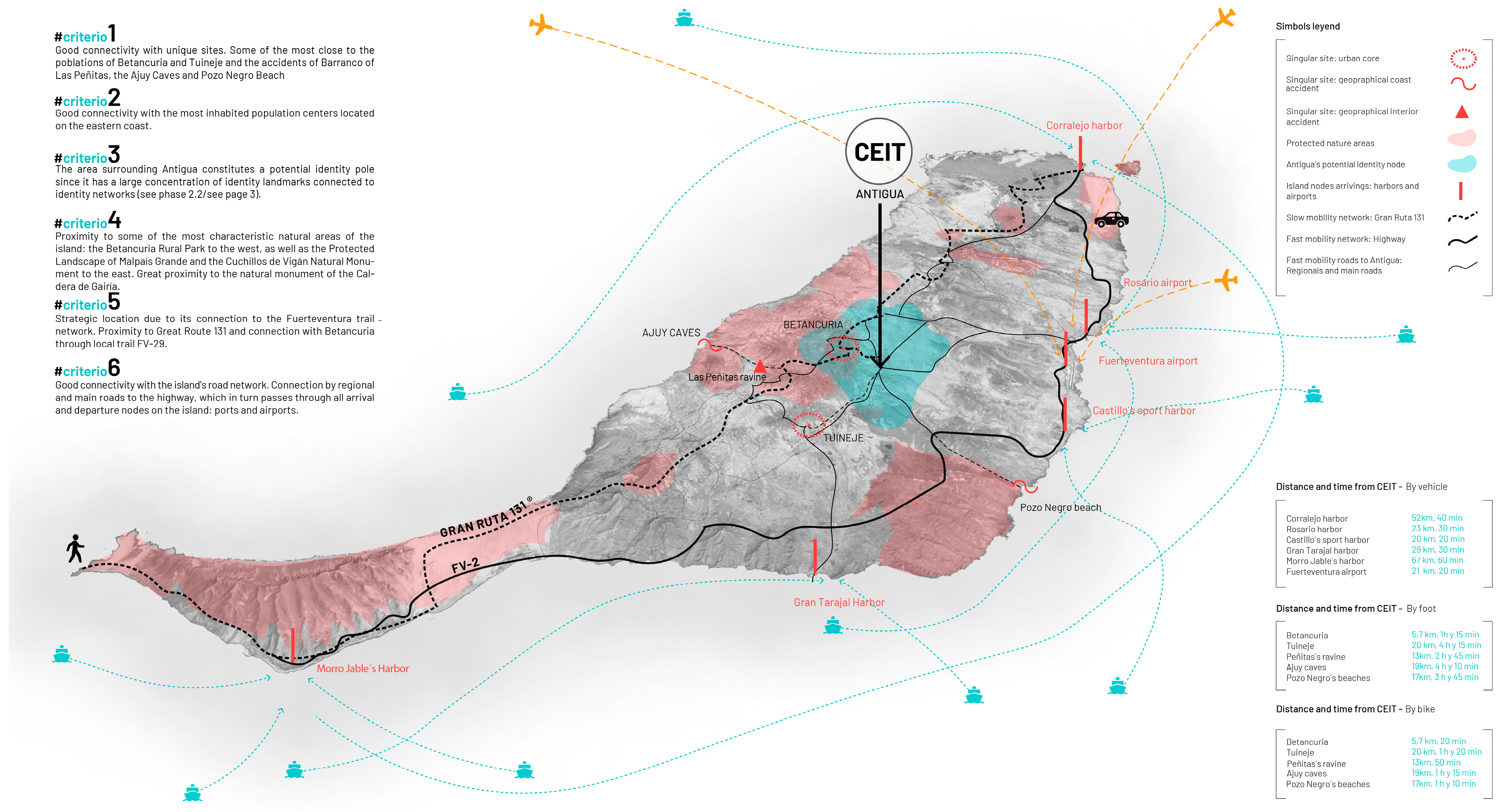
As part of the design of the tourist space, we propose to incorporate a reference point in the territory called the Tourist Experience and Interpretation Centre (CEIT). Its objectives include welcoming visitors, providing them with information on territorial resources and visit options, and interpreting and conveying the heritage, natural, historical, social, cultural, and ethnographic values of the territory. The specific location of the CEIT is part of the territorial strategy. The choice of its location is based on six overlapping criteria: (1) connectivity with unique natural and cultural enclaves; (2) connectivity with the most populated population centres in the surrounding area; (3) proximity to tourist attraction poles; (4) proximity to protected natural areas; (5) connectivity with slow mobility networks; and (6) connectivity with fast mobility networks and with the main transportation hubs in the territory.
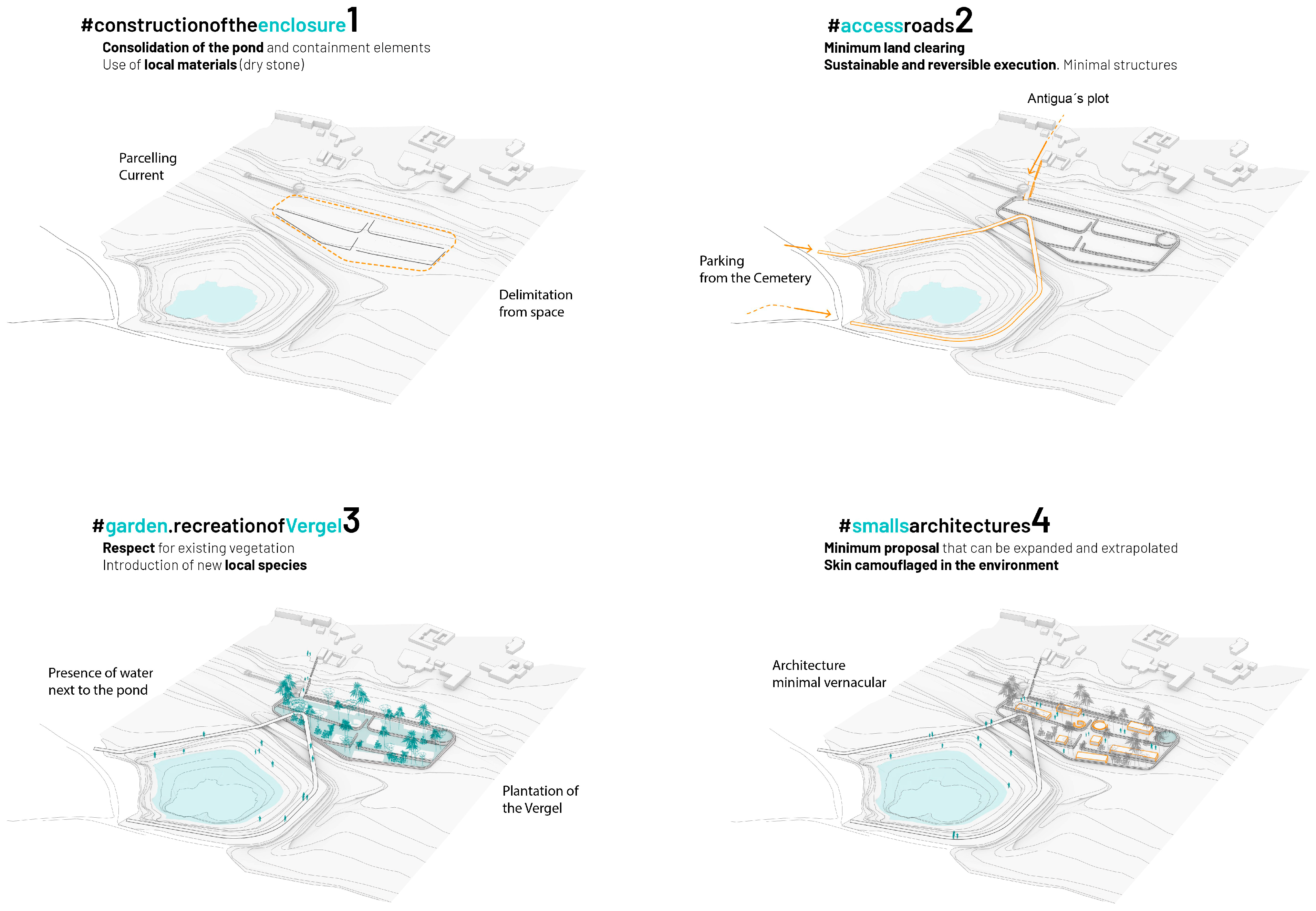
The sustainable architectural strategy for designing the CEIT is part of the methodology. Architectures of minimum impact, both visual and ecological, should be proposed using sustainable techniques and local materials available in the environment during the construction process. These architectures, from a contemporary conceptualisation, will contain the identifying features of the territory and be integrated into the landscape, both conceptually and physically, and be capable of speaking for themselves about the place in which they are inserted. As we will see, in order to materialise these pieces, the design of green areas and public spaces is as important as the built architectures themselves.
3. Results
Although the methodological framework presented has been designed to be applicable to any territory of low demographic density susceptible to experiencing tourism promotion strategies based on its heritage content and significance, Fuerteventura is the territory chosen as an experimental enclave to study its applicability. Fuerteventura is the second-largest island (about 1700 km2) of the Canary Islands. It stands out because it is one of the driest islands of the archipelago, with little visual reference to vegetation. The coastline contrasts between windward cliffs on the western coast and wide leeward beaches on the eastern coast. A total of 47% of the territory is a biosphere reserve with some type of environmental protection, and 53% of the coastline has marine protection. The primary production activities have been reduced to a minimum with the development of mass tourism since the 1970s. Today, 2.3% of the population is engaged in rural activities, 7.5% in the construction sector, and 86% in the service sector (tourism) due to both the tourist boom and the depletion of soils and aquifers of the former “granary of the Canary Islands”. Furthermore, being one of the largest Canary Islands in terms of extension, Fuerteventura has been chosen for this research due to the vulnerability of several areas of the island considered sparsely populated areas according to the European Parliament’s definition from September 2016 and the monoculture economy based on tourism in several coastal poles which causes territorial imbalances within the island and the remote towns placed in the geographical centre of the island where poor transport links make the socioeconomic growth of this part of the island difficult.
It has about 105,000 inhabitants in 80 population centres. This does not mean that dispersion equals imbalance, as countries like Canada or others in Northern Europe have a high level of well-being. Most of them are very small, organised into six municipalities which are, from north to south, La Oliva, Puerto del Rosario, Betancuria, Antigua, Tuineje, and Pájara. The capital is Puerto del Rosario, although Betancuria was the first town founded on any of the Canary Islands in 1405 by Norman and Spanish settlers [
32]. Tourism development caused the island’s population figures to increase year after year since the 1980s, doubling in just over a decade. However, beach tourism is heavily concentrated on the most accessible coasts of the island and has traditionally been unrelated to the cultural richness of the island. In order to determine the suitability of the proposed strategy, the phases described above have been developed in this case study, obtaining the results shown below.
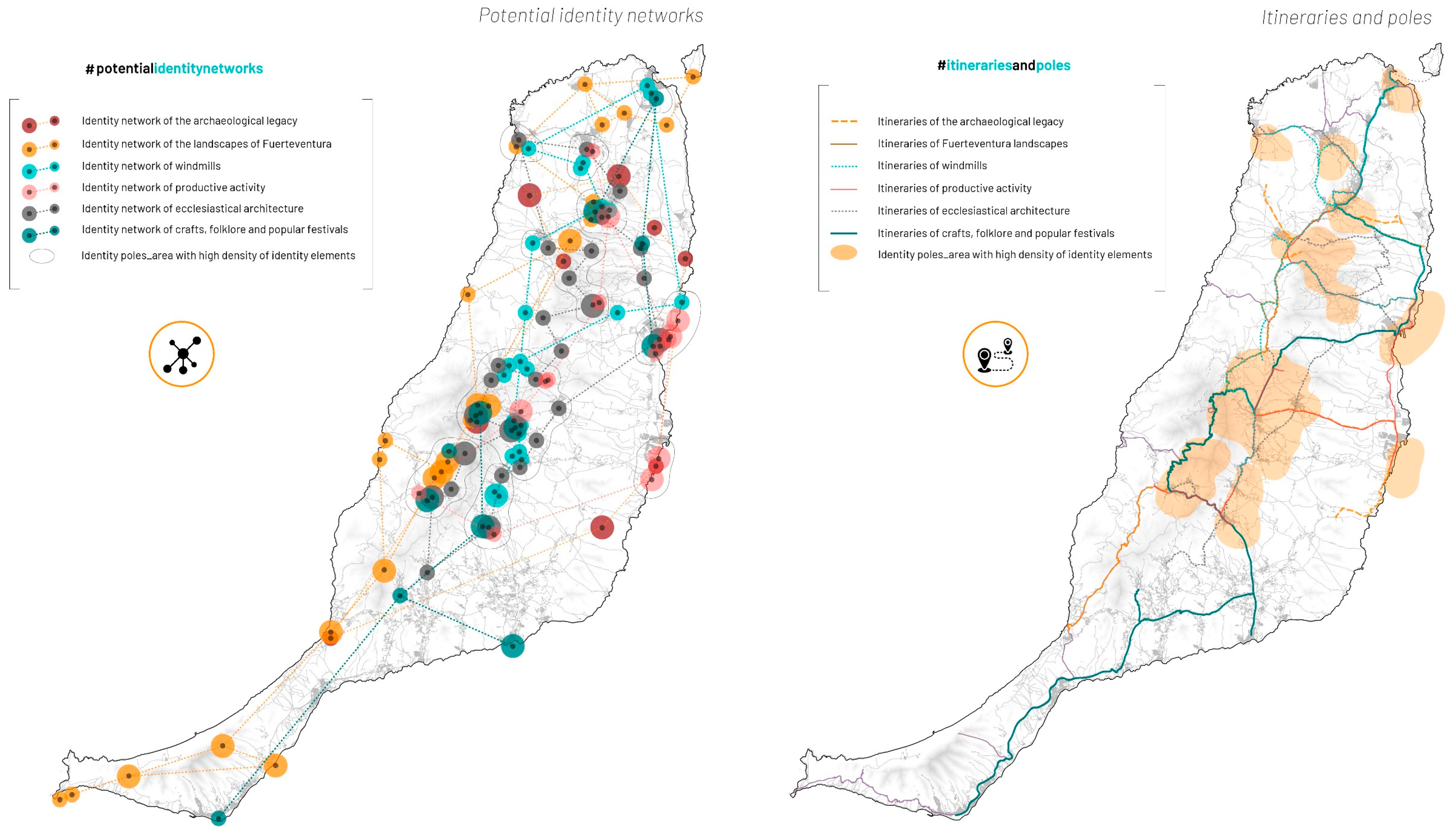
First, the historical evolution of the cultural landscape of Fuerteventura was studied. This first phase used graphic and documentary historical documents of the island that allowed a sequential axis to be built on its successive transformations, linking them to historical events, socio-political contexts, etc. As a result of this work, six types of essential heritage structures of the island territory were detected, which generated, in the second phase of the methodology, the heritage networks of Fuerteventura (
Figure 2). The first network refers to the archaeological component of the place, that is, to the successive anthropisation of the territory in relation to the natural surroundings. In it, we identify the volcanic origin of the island of Fuerteventura and the remains of the first manifestations of the indigenous culture. The second network encompasses the natural and cultural landscapes of the island. The natural landscapes derive from volcanic action, and notable among them is the contrast between steep ravines and charcones, natural saltwater pools. The cultural landscapes correspond to the small island villages where the arid environment contrasts with a white vernacular architecture surrounded by vegetation, the village of Betancuria being the highest representation of this quality. The third network is determined by the geographical location of the island, which is strongly affected by the trade winds. Historically, they have been exploited through the construction of mills, built mainly to extract water, a scarce resource on the surface, from the subsoil. This has generated a rich network of windmills that characterise the island. The fourth network includes the manifestations of the production activity of the area, mainly allocated to the production of cereal and lime and the storage and breeding of cattle. From this activity, unique typological varieties have been found, such as taros, used for cheese curing. The fifth network encompasses the enclaves of ecclesiastical power in Fuerteventura, nodes of population concentration, and municipalities that bear witness to the incorporation of the religious tradition of the conquerors and settlers of marked Franciscan influence. Finally, the last network corresponds to the intangible heritage of Fuerteventura in the form of festivities, traditions, folklore, and popular crafts.
After identifying these six heritage networks, which encapsulate the wealth of the island’s heritage, the third phase of the methodology connects the heritage elements of each network by means of the existing mobility structure, understood as the current pedestrian, road, and public transport routes. Thus, six thematic itineraries are defined that will allow tourists to construct their own dimension and reality of the surrounding territory, and to understand the connection of the heritage elements of each of the networks with each other and with the landscape (
Figure 3).
These itineraries, or routes, take into consideration the importance of tourism on foot. As F. Careri [
33] stated, “Through walking, categories have been formed with which we interpret anthropised landscapes”. In addition to the itineraries, by means of the networks, it is also possible to define, by studying the concentration of heritage resources and their relevance, the poles of tourist attraction of the island territory that will be destinations of congregation and the beginning of the routes, helping the distribution and organisation of the tourist activity. The fourth phase of the methodology deals with the location of the poles. In addition to these poles of tourist attraction, there will be a central space that will organise the tourist space, the Centre of Experience and Tourist Interpretation (CEIT). In order to decide on an optimal location for the centre, the fifth phase of the work analyses both the island regulatory requirements
1 and the six criteria described in the methodological framework (
Figure 4). These criteria allow us to detect an intensification of heritage resources in the north and centre of the island, a balanced distribution of its protected natural areas, an organisation of the communication system through a central axis that crosses the island in a north–south direction, and a distribution of the population and the main communication infrastructures on the eastern coast. The synthesis of these variables has made it possible to define the town of Antigua as the optimum site for the location of the CEIT (
Figure 5).
The enclave of Antigua has a direct connection with the air and port services of Puerto del Rosario through the FV-20 road and with the defined potential itineraries. With a population of 12,738 inhabitants (2021) and an approximate population density of 42 inhabitants/km2 according to the Canary Islands Institute of Statistics (ISTAC), Antigua is the second-least populated area, and low population density Fuerteventura Island is among the rural areas of the Canary Islands Rural Development Program 2014–2020 (according to the Canary Islands Spatial Data Infrastructure—IDE Canarias) approved by the European Commission in 2015. Most of the island territory is made up of essentially rural areas, which are vulnerable to social exclusion and have fewer opportunities for growth. According to the Briefing of September 2016 of the European Parliament about sparsely populated and under-populated areas, factors for considering a rural area include communities with population densities slightly higher than 30 inhabitants/km2 but placed in remote placements, lack of proper connections of transport and employment, as well as educational formation, monoculture economies, and long distances to urban and relevant nodes. Except for the northern node corresponding to the municipality of Corralejo and its surroundings, the area between Caleta de Fustes and Puerto del Rosario—this being one of the most important urban nodes due to the presence of airport and port activities—and, finally, the southern part of the Jandía Peninsula. Antigua is the equidistant centre of these three urban centres, making it a fundamental node for the connectivity and accessibility of the island’s tourist flows.
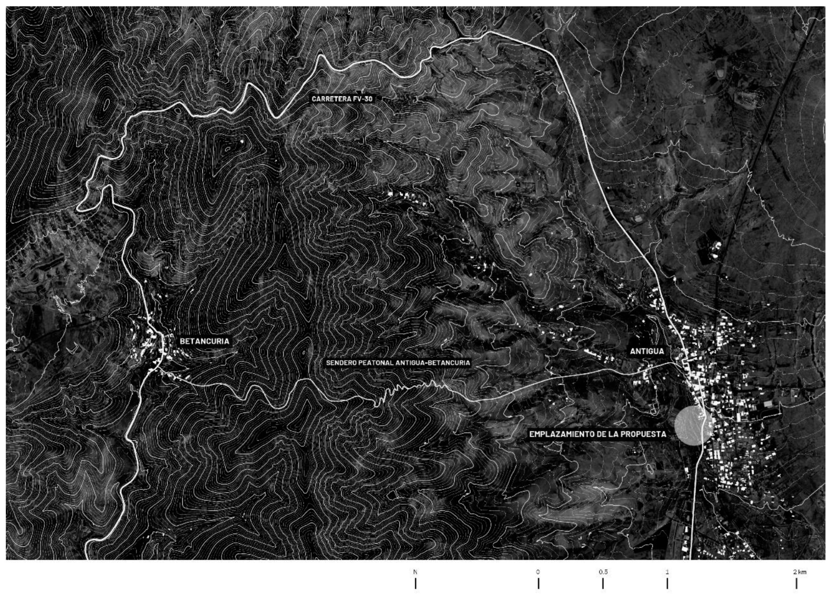
In addition to these connective factors, Antigua is located on the eastern front of the pronounced orography of the Betancuria Rural Park (
Figure 6), presided over by the ‘morrete’ of Betancuria, the first settlement on the island, as we have mentioned. The park extends to the coast of Ajuy, encompassing a multitude of ‘charcones’, ‘morretes’—summits of the pronounced orography above the valleys—and cultivated valleys on its perimeter [
34]. Thus, in Antigua’s surroundings, you can experience a diversity of landscapes characterised by the island’s orographic and botanical heterogeneity. Therefore, the CEIT will be located in an environment consistent with the local characteristics and identity of the island’s society and architecture (
Figure 7). In addition, Antigua is a site of agricultural activities (fallow land, potatoes, citrus, temperate and subtropical fruit trees, etc.) and cultural activities such as the Crafts Festival and the production of Majorero cheese, among others. In addition to these specific values of Antigua, there are practical issues that are relevant to the selection of the specific CEIT location, including proximity to the cemetery parking lot (which avoids building another specific parking lot for the new facility) and the existence of a water reservoir with slopes of earth.


 ,
, 


