
Geoinformation Technology in Support of Arctic Coastal Properties Characterization: State of the Art, Challenges, and Future Outlook


Abstract
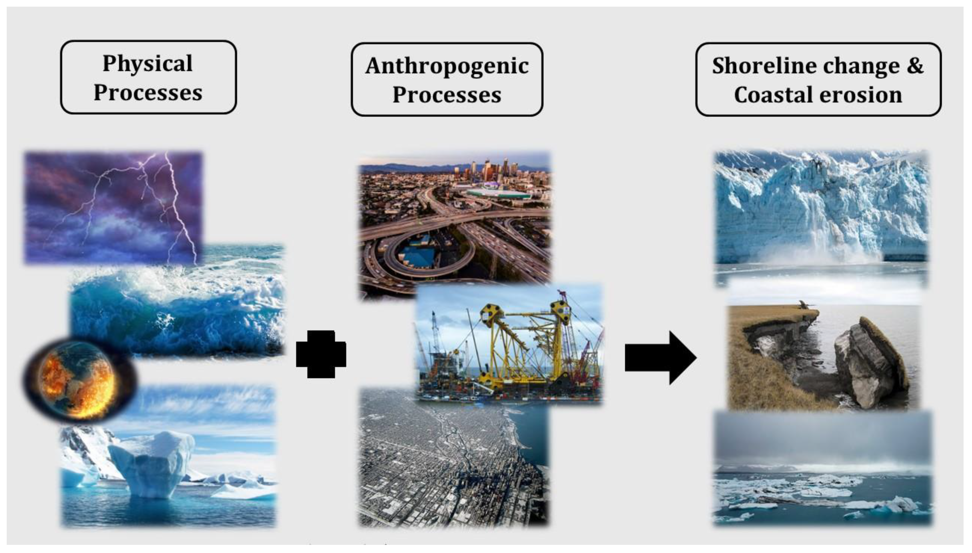
1. Introduction
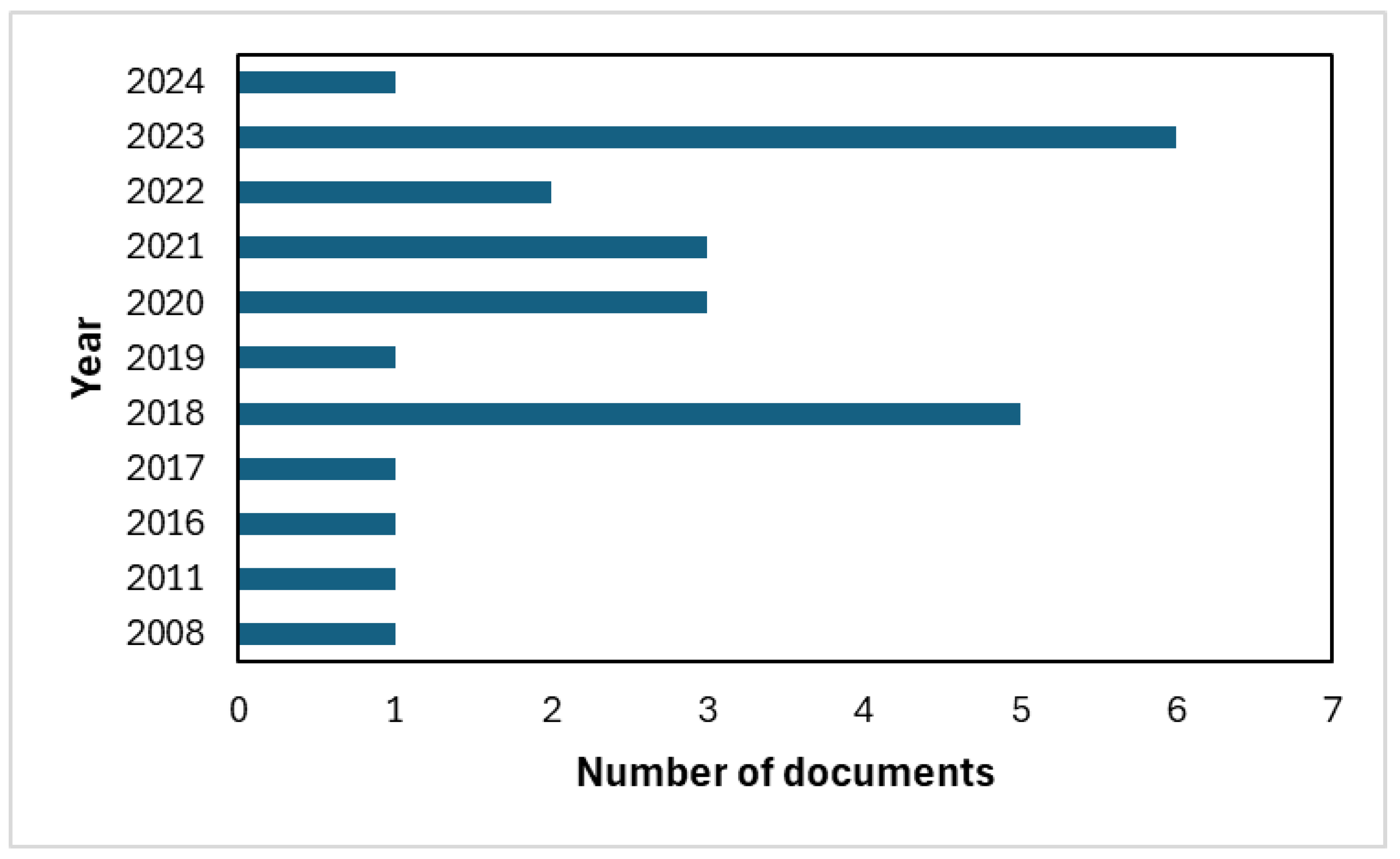
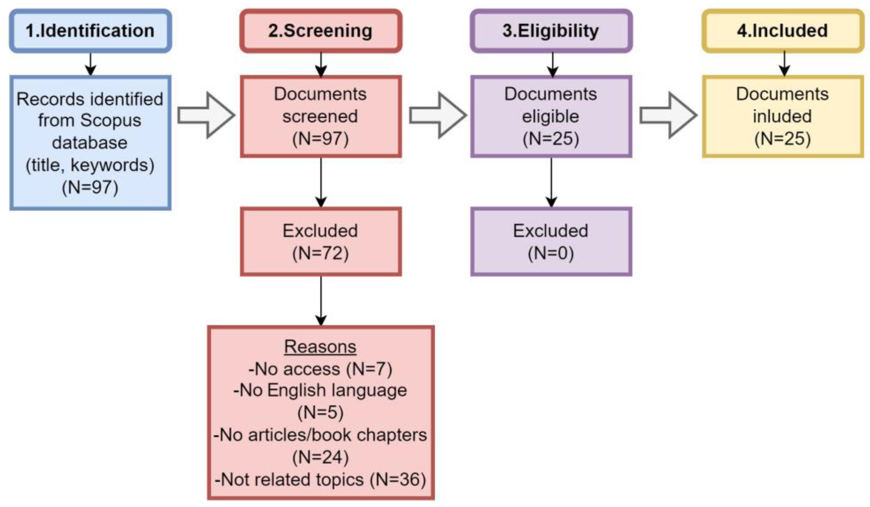
2. Overall Methodological Approach
3. Coastal Management Approaches for Earth Observation in Arctic Area
3.1. Approaches for Coastline Extraction in Arctic Regions
3.1.1. Manual Visual Interpretation
3.1.2. Automatic Computer-Assisted Interpretation
Segmentation-Based Methods
Classification-Based Methods
Hybrid Methods
3.2. Approaches for Quantifying Coastal Vulnerability in Arctic Areas
3.3. Software Tools for Shoreline Property Analysis in Arctic Regions
3.3.1. Digital Shoreline Analysis System (DSAS)
- Shoreline Change Envelope (SCE)—the total change in position of the coastline under consideration is measured;
- Net Shoreline Movement (NSM)—determines the distance between the oldest and the newest coastline;
- End Point Rate (EPR)—is determined by the distance of shoreline movement over the study period;
- Linear Regression Rate (LRR)—identifies a statistical rate of change by fitting a least squares regression to all coastlines at a particular intersection;
- The DSAS tool determines the morphodynamical behavior of the shoreline and its displacement associated with the geometry of the coastal zone [74].
3.3.2. CoastSAT
3.3.3. Shoreline Analysis and Extraction Tool (SAET)
3.3.4. Coastal Analyst System from Space Imagery Engine (CASSIE)
3.4. Socio-Economic Studies and Coastal Properties
4. Relevant EO-Related Datasets, Platforms, and Projects Focusing on the Arctic
4.1. EO Datasets
4.2. Relevant EO Projects
5. Scientific Challenges concerning the Use of EO/GIS in the Study of the Arctic Coast Properties
- (a)
- Regarding the coastal mapping detailed in Section 3.1:
- There is a notable challenge for finding suitable EO data for monitoring Arctic coasts. Optical data, the type of data most used in such studies, is severely limited by the increased cloud cover observed in the circumpolar Arctic and the coarse spatial resolution. Similarly, it is only from 2014 onwards that SAR imagery is available, mainly from the Sentinel-1 satellite.
- (b)
- Concerning the methodologies employed for coastal mapping and erosion in Arctic regions, it is important to establish a common line or methodology protocol. Our review revealed that there is no specific action plan to follow in the case of studying coastline erosion. Regarding the coastal vulnerability detailed in Section 3.2:
- The coastal vulnerability in the Arctic is estimated using methods that account for factors such as habitat type, geomorphology, shoreline change rate, etc. Yet, in all the methods employed so far in the Arctic, these factors are weighed equally, which might not be the case in the real world. Consequently, further research is required in that direction, which will allow accounting for the weight of each factor in an objective way that will be user independent. In addition, a methodological framework should be developed towards assessing the accuracy of the derived vulnerability maps for the Arctic regions.
- Our review also evidenced that there is low awareness of the potential hazards and risks associated with coastal erosion, while as a result, there are limited strategies and area plans in place to proactively protect the high-risk regions.
- (c)
- Regarding the software tools for shoreline property analysis detailed in Section 3.3:
- Although there is an abundance of software tools able to analyze shoreline characteristics, these tools are still based on simple techniques used to perform their analysis. State-of-the-art tools such as deep learning models, which outperform the thresholding techniques on which most software tools are based, have yet to be explored and potentially be integrated into these software tools. In addition, these software tools should include advanced capabilities, such as the ability to handle a big volume of data or performing computing processing in parallel processing, e.g., exploiting the power of high-performance computing.
- (d)
- Regarding the socioeconomic studies detailed in Section 3.4:
- Socioeconomic studies that combine EO-based datasets with socioeconomic datasets are still rather limited for the Arctic region. The main reasons that hinder these approaches include the spatial mismatch between the EO-based indices and the socioeconomic datasets needed for these kinds of analysis. Evidently, future work is of paramount importance towards assessing the socioeconomic impacts of climate change in coastal areas exploiting geoinformation technologies.
- (e)
- Regarding the relevant EO-related studies, platforms, and projects detailed in Section 4:
- The important contribution of geoinformation technologies such as EO and GIS has been recognized globally, e.g., by the fact that several EO- and cloud-based platforms (e.g., Permafrost CCI, Globpermafrost, APGC) are available supporting Arctic-related research. Yet, there is no single geoportal or WebGIS platform that collects and provides all the EO datasets for the Arctic in a systematic way, examining also the potential socio-economic impacts of climate change in Arctic coastal areas. Thus, there is an urgent need towards this directive.
6. Final Remarks
Author Contributions
Funding
Data Availability Statement
Acknowledgments
Conflicts of Interest
References
- Malhi, Y.; Franklin, J.; Seddon, N.; Solan, M.; Turner, M.G.; Field, C.B.; Knowlton, N. Climate Change and Ecosystems: Threats, Opportunities and Solutions. Philos. Trans. R. Soc. B 2020, 375, 20190104. [Google Scholar] [CrossRef] [PubMed]
- Nguyen, T.T.X.; Bonetti, J.; Rogers, K.; Woodroffe, C.D. Indicator-Based Assessment of Climate-Change Impacts on Coasts: A Review of Concepts, Methodological Approaches and Vulnerability Indices. Ocean. Coast. Manag. 2016, 123, 18–43. [Google Scholar] [CrossRef]
- Bennett, N.; Blythe, J.; Tyler, S.; Ban, N.C. Communities and Change in the Anthropocene: Understanding Social-Ecological Vulnerability and Planning Adaptations to Multiple Interacting Exposures. Reg. Environ. Change 2016, 16, 907–926. [Google Scholar] [CrossRef]
- Chen, C.; Bu, J.; Zhang, Y.; Zhuang, Y.; Chu, Y.; Hu, J.; Guo, B. The Application of the Tasseled Cap Transformation and Feature Knowledge for the Extraction of Coastline Information from Remote Sensing Images. Adv. Space Res. 2019, 64, 1780–1791. [Google Scholar] [CrossRef]
- Yang, X.; Zhu, Z.; Qiu, S.; Kroeger, K.D.; Zhu, Z.; Covington, S. Detection and Characterization of Coastal Tidal Wetland Change in the Northeastern US Using Landsat Time Series. Remote Sens. Environ. 2022, 276, 113047. [Google Scholar] [CrossRef]
- Frederick, J.; Thomas, M.A.; Bull, D.L.; Jones, C.; Roberts, J. The Arctic Coastal Erosion Problem; Sandia National Laboratories: Albuquerque, NM, USA, 2016. [Google Scholar] [CrossRef]
- Philipp, M.; Dietz, A.J.; Ullmann, T.; Kuenzer, C. Automated Extraction of Annual Erosion Rates for Arctic Permafrost Coasts Using Sentinel-1, Deep Learning, and Change Vector Analysis. Remote Sens. 2022, 14, 3656. [Google Scholar] [CrossRef]
- Jones, B.M.; Irrgang, A.M.; Farquharson, L.M.; Lantuit, H.; Whalen, D.; Ogorodov, S. The Sustained Transformation to a Warmer, Less Frozen and Biologically Changed Arctic Remains Clear. Arctic Report Card: Update for 2020. 2020. Available online: https://arctic.noaa.gov/Report-Card/Report-Card-2020/ArtMID/7975/ArticleID/904/Coastal-Permafrost-Erosion (accessed on 29 March 2024).
- Jones, B.; Farquharson, L.M.; Baughman, C.A.; Buzard, R.M.; Arp, C.D.; Grosse, G.; Bull, D.L.; Günther, F.; Nitze, I.; Urban, F.E.; et al. A Decade of Remotely Sensed Observations Highlight Complex Processes Linked to Coastal Permafrost Bluff Erosion in the Arctic. Environ. Res. Lett. 2018, 13, 115001. [Google Scholar] [CrossRef]
- Maslakov, A.; Kraev, G. Erodibility of Permafrost Exposures in the Coasts of Eastern Chukotka. Polar Sci. 2016, 10, 374–381. [Google Scholar] [CrossRef]
- Liu, C.; Chang, J.; Chen, M.; Zhang, T. Dynamic Monitoring and Its Influencing Factors Analysis of Coastline in the Laizhou Bay since 1985. J. Coast. Res. 2020, 105, 18–22. [Google Scholar] [CrossRef]
- Lantuit, H.; Overduin, P.; Wetterich, S. Recent Progress Regarding Permafrost Coasts. Permafr. Periglac. Process. 2013, 24, 120–130. [Google Scholar] [CrossRef]
- Zhang, Y.; Hou, X. Characteristics of Coastline Changes on Southeast Asia Islands from 2000 to 2015. Remote Sens. 2020, 12, 519. [Google Scholar] [CrossRef]
- Farquharson, L.M.; Mann, D.H.; Swanson, D.K.; Jones, B.; Buzard, R.M.; Jordan, J.W. Temporal and Spatial Variability in Coastline Response to Declining Sea-Ice in Northwest Alaska. Mar. Geol. 2018, 404, 71–83. [Google Scholar] [CrossRef]
- De Serio, F.; Armenio, E.; Mossa, M.; Petrillo, A. How to Define Priorities in Coastal Vulnerability Assessment. Geosciences 2018, 8, 415. [Google Scholar] [CrossRef]
- Rocha, C.; Antunes, C.; Catita, C. Coastal Indices to Assess Sea-Level Rise Impacts—A Brief Review of the Last Decade. Ocean. Coast. Manag. 2023, 237, 106536. [Google Scholar] [CrossRef]
- Sun, W.; Chen, C.; Liu, W.; Yang, G.; Meng, X.; Wang, L.; Ren, K. Coastline Extraction Using Remote Sensing: A Review. Gisci. Remote Sens. 2023, 60, 2243671. [Google Scholar] [CrossRef]
- El-Kafrawy, S.B.; Basheer, M.A.; Mohamed, H.M.; Naguib, D.M. Applications of Remote Sensing and GIS Techniques to Evaluate the Effectiveness of Coastal Structures along Burullus Headland-Eastern Nile Delta, Egypt. Egypt. J. Remote Sens. Space Sci. 2021, 24, 247–254. [Google Scholar] [CrossRef]
- Noor, N.M.; Maulud, K.N.A. Coastal Vulnerability: A Brief Review on Integrated Assessment in Southeast Asia. J. Mar. Sci. Eng. 2022, 10, 595. [Google Scholar] [CrossRef]
- Im, J. Earth Observations and Geographic Information Science for Sustainable Development Goals. Gisci. Remote Sens. 2020, 57, 591–592. [Google Scholar] [CrossRef]
- Kouhgardi, E.; Hemati, M.; Shakerdargah, E.; Shiri, H.; Mahdianpari, M. Monitoring Shoreline and Land Use/Land Cover Changes in Sandbanks Provincial Park Using Remote Sensing and Climate Data. Water 2022, 14, 3593. [Google Scholar] [CrossRef]
- Handiani, D.N.; Heriati, A.; Gunawan, W.A. Comparison of Coastal Vulnerability Assessment for Subang Regency in North Coast West Java-Indonesia. Geomat. Nat. Hazards Risk 2022, 13, 1178–1206. [Google Scholar] [CrossRef]
- Ankrah, J.; Monteiro, A.; Madureira, H. Shoreline Change and Coastal Erosion in West Africa: A Systematic Review of Research Progress and Policy Recommendation. Geosciences 2023, 13, 59. [Google Scholar] [CrossRef]
- Eliades, M.; Michaelides, S.; Evagorou, E.; Fotiou, K.; Fragkos, K.; Leventis, G.; Theocharidis, C.; Panagiotou, C.F.; Mavrovouniotis, M.; Neophytides, S.; et al. Earth Observation in the EMMENA Region: Scoping Review of Current Applications and Knowledge Gaps. Remote Sens. 2023, 15, 4202. [Google Scholar] [CrossRef]
- Cavalli, R.M. Remote Data for Mapping and Monitoring Coastal Phenomena and Parameters: A Systematic Review. Remote Sens. 2024, 16, 446. [Google Scholar] [CrossRef]
- Murray, J.; Adam, E.; Woodborne, S.; Miller, D.; Xulu, S.; Evans, M. Monitoring Shoreline Changes along the Southwestern Coast of South Africa from 1937 to 2020 Using Varied Remote Sensing Data and Approaches. Remote Sens. 2023, 15, 317. [Google Scholar] [CrossRef]
- Duarte, C.R.; Miranda, F.; Landau, L.; Souto, M.V.S.; Sabadia, J.A.B.; Da Silva Neto, C.Â.; De Castro Rodrigues, L.I.; Damasceno, A.M. Short-Time Analysis of Shoreline Based on RapidEye Satellite Images in the Terminal Area of Pecém Port, Ceará, Brazil. Int. J. Remote Sens. 2018, 39, 4376–4389. [Google Scholar] [CrossRef]
- Qiu, L.; Zhang, M.; Zhou, B.; Cui, Y.; Yu, Z.; Liu, T.; Wu, S. Economic and Ecological Trade-Offs of Coastal Reclamation in the Hangzhou Bay, China. Ecol. Indic. 2021, 125, 107477. [Google Scholar] [CrossRef]
- Novikova, A.; Belova, N.; Baranskaya, A.; Aleksyutina, D.; Maslakov, A.; Zelenin, E.; Shabanova, N.; Ogorodov, S. Dynamics of Permafrost Coasts of Baydaratskaya Bay (Kara Sea) Based on Multi-Temporal Remote Sensing Data. Remote Sens. 2018, 10, 1481. [Google Scholar] [CrossRef]
- Sinitsyn, A.; Guégan, E.; Shabanova, N.; Kokin, O.; Ogorodov, S. Fifty Four Years of Coastal Erosion and Hydrometeorological Parameters in the Varandey Region, Barents Sea. Coast. Eng. 2020, 157, 103610. [Google Scholar] [CrossRef]
- Wang, J.; Li, D.; Cao, W.; Lou, X.; Shi, A.; Zhang, H. Remote Sensing Analysis of Erosion in Arctic Coastal Areas of Alaska and Eastern Siberia. Remote Sens. 2022, 14, 589. [Google Scholar] [CrossRef]
- Cooley, S.W.; Smith, L.C.; Ryan, J.C.; Pitcher, L.H.; Pavelsky, T. Arctic—Boreal Lake Dynamics Revealed Using CubeSat Imagery. Geophys. Res. Lett. 2019, 46, 2111–2120. [Google Scholar] [CrossRef]
- Nylén, T.N.; Gonzales-Inca, C.; Calle Navarro, M. Procedure for examining long-term Arctic shoreline displacement from multispectral satellite data. In Proceedings of the EGU General Assembly 2023, Vienna, Austria, 24–28 April 2023. EGU23-11651. [Google Scholar] [CrossRef]
- Moussa, R.M.; Fogg, L.; Bertucci, F.; Calandra, M.; Collin, A.; Aubanel, A.; Polti, S.; Benet, A.; Salvat, B.; Galzin, R.; et al. Long-Term Coastline Monitoring on a Coral Reef Island (Moorea, French Polynesia). Ocean. Coast. Manag. 2019, 180, 104928. [Google Scholar] [CrossRef]
- Lantuit, H.; Pollard, W.H. Fifty Years of Coastal Erosion and Retrogressive Thaw Slump Activity on Herschel Island, Southern Beaufort Sea, Yukon Territory, Canada. Geomorphology 2008, 95, 84–102. [Google Scholar] [CrossRef]
- Zagórski, P. Shoreline Dynamics of Calypsostranda (NW Wedel Jarlsberg Land, Svalbard) during the Last Century. Pol. Polar Res. 2011, 32, 67–99. [Google Scholar] [CrossRef]
- Jaskólski, M.; Pawłowski, Ł.; Strzelecki, M.C. High Arctic Coasts at Risk—The Case Study of Coastal Zone Development and Degradation Associated with Climate Changes and Multidirectional Human Impacts in Longyearbyen (Adventfjorden, Svalbard). Land Degrad. Dev. 2018, 29, 2514–2524. [Google Scholar] [CrossRef]
- Irrgang, A.; Lantuit, H.; Manson, G.K.; Günther, F.; Grosse, G.; Overduin, P. Variability in Rates of Coastal Change along the Yukon Coast, 1951 to 2015. J. Geophys. Res. Earth Surf. 2018, 123, 779–800. [Google Scholar] [CrossRef]
- Günther, F.; Overduin, P.P.; Sandakov, A.V.; Grosse, G.; Grigoriev, M.N. Short- and long-term thermo-erosion of ice-rich permafrost coasts in the Laptev Sea region. Biogeosciences 2013, 10, 4297–4318. [Google Scholar] [CrossRef]
- Bartsch, A.; Ley, S.; Nitze, I.; Pointner, G.; Vieira, G. Feasibility Study for the Application of Synthetic Aperture Radar for Coastal Erosion Rate Quantification across the Arctic. Front. Environ. Sci. 2020, 8, 143. [Google Scholar] [CrossRef]
- Zagórski, P.; Jarosz, K.; Superson, J. Integrated Assessment of Shoreline Change along the Calypsostranda (Svalbard) from Remote Sensing, Field Survey and GIS. Mar. Geod. 2020, 43, 433–471. [Google Scholar] [CrossRef]
- Nicu, I.C.; Rubensdotter, L.; Stalsberg, K.; Nau, E. Coastal Erosion of Arctic Cultural Heritage in Danger: A Case Study from Svalbard, Norway. Water 2021, 13, 784. [Google Scholar] [CrossRef]
- Novikova, A.; Vergun, A.; Zelenin, E.; Baranskaya, A.; Ogorodov, S. Determining Dynamics of the Kara Sea Coasts Using Remote Sensing and UAV Data: A Case Study. Russ. J. Earth Sci. 2021, 21, ES3004. [Google Scholar] [CrossRef]
- Belova, N.; Ermolov, A.; Novikova, A.; Ogorodov, S.; Stanilovskaya, Y.V. Dynamics of Low-Lying Sandy Coast of the Gydan Peninsula, Kara Sea, Russia, Based on Multi-Temporal Remote Sensing Data. Remote Sens. 2022, 15, 48. [Google Scholar] [CrossRef]
- Tanguy, R.; Whalen, D.; Prates, G.; Vieira, G. Shoreline Change Rates and Land to Sea Sediment and Soil Organic Carbon Transfer in Eastern Parry Peninsula from 1965 to 2020 (Amundsen Gulf, Canada). Arct. Sci. 2023, 9, 506–525. [Google Scholar] [CrossRef]
- Ziaja, W.; Ostafin, K.; Maciejowski, W.; Kruse, F. Coastal Landscape Degradation and Disappearance of Davislaguna Lake, Sørkappland, Svalbard, 1900–2021. Land Degrad. Dev. 2023, 34, 4823–4832. [Google Scholar] [CrossRef]
- Kazhukalo, G.; Novikova, A.; Shabanova, N.; Drugov, M.; Myslenkov, S.; Shabanov, P.; Belova, N.; Ogorodov, S. Coastal Dynamics at Kharasavey Key Site, Kara Sea, Based on Remote Sensing Data. Remote Sens. 2023, 15, 4199. [Google Scholar] [CrossRef]
- Tsai, Y.-L. Monitoring Arctic Permafrost Coastal Erosion Dynamics Using a Multidecadal Cross-Mission SAR Dataset along an Alaskan Beaufort Sea Coastline. Sci. Total Environ. 2024, 917, 170389. [Google Scholar] [CrossRef] [PubMed]
- Zhang, Y. Environmental Monitoring of Spatial-Temporal Changes Using Remote Sensing and GIS Techniques in the Abandoned Yellow River Delta Coast, China. Int. J. Environ. Pollut. 2011, 45, 327. [Google Scholar] [CrossRef]
- Sekar, C.S.; Kankara, R.S.; Kalaivanan, P. Pixel-Based Classification Techniques for Automated Shoreline Extraction on Open Sandy Coast Using Different Optical Satellite Images. Arab. J. Geosci. 2022, 15, 939. [Google Scholar] [CrossRef]
- Ghassemian, H. A Review of Remote Sensing Image Fusion Methods. Inf. Fusion 2016, 32, 75–89. [Google Scholar] [CrossRef]
- Gašparović, M.; Jogun, T. The Effect of Fusing Sentinel-2 Bands on Land-Cover Classification. Int. J. Remote Sens. 2017, 39, 822–841. [Google Scholar] [CrossRef]
- Yu, Y.; Zhang, Z.; Shokr, M.; Hui, F.; Cheng, X.; Chi, Z.; Heil, P.; Chen, Z. Automatically Extracted Antarctic Coastline Using Remotely-Sensed Data: An Update. Remote Sens. 2019, 11, 1844. [Google Scholar] [CrossRef]
- De Vries, J.; Van Maanen, B.; Ruessink, G.; Verweij, P.A.; De Jong, S.M. Unmixing Water and Mud: Characterizing Diffuse Boundaries of Subtidal Mud Banks from Individual Satellite Observations. Int. J. Appl. Earth Obs. Geoinf. 2021, 95, 102252. [Google Scholar] [CrossRef]
- Chen, Z.; Pasher, J.; Duffe, J.; Behnamian, A. Mapping Arctic Coastal Ecosystems with High Resolution Optical Satellite Imagery Using a Hybrid Classification Approach. Can. J. Remote Sens. 2017, 43, 513–527. [Google Scholar] [CrossRef]
- Aryal, B.; Escarzaga, S.M.; Zesati, S.A.V.; Vélez-Reyes, M.; Fuentes, O.; Tweedie, C. Semi-Automated Semantic Segmentation of Arctic Shorelines Using Very High-Resolution Airborne Imagery, Spectral Indices and Weakly Supervised Machine Learning Approaches. Remote Sens. 2021, 13, 4572. [Google Scholar] [CrossRef]
- IPCC. Climate Change 2013—The Physical Science Basis. Contribution of Working Groups I, II and III to the Fifth Assessment Report of the Intergovernmental Panel on Climate Change, Intergovernmental Panel on Climate Change; Climate Change 2014: Synthesis Report; Sydowed, I., Ed.; Cambridge University Press: Cambridge, UK, 2014. [Google Scholar]
- Parthasarathy, K.S.S.; Deka, P.C. Remote sensing and GIS application in assessment of coastal vulnerability and shoreline changes: A review. ISH J. Hydraul. Eng. 2021, 27, 588–600. [Google Scholar] [CrossRef]
- Silva, R.; Chávez, V.; Bouma, T.J.; Van Tussenbroek, B.I.; Arkema, K.K.; Martínez, M.L.; Oumeraci, H.; Heymans, J.J.; Osorio, A.F.; Mendoza, E.; et al. The Incorporation of Biophysical and Social Components in Coastal Management. Estuaries Coasts 2019, 42, 1695–1708. [Google Scholar] [CrossRef]
- Ummenhofer, C.C.; Meehl, G.A. Extreme Weather and Climate Events with Ecological Relevance: A Review. Philos. Trans. R. Soc. B 2017, 372, 20160135. [Google Scholar] [CrossRef] [PubMed]
- Cruz-Ramírez, C.J.; Chávez, V.; Silva, R.; Muñoz-Pérez, J.J.; Rivera-Arriaga, E. Coastal Management: A Review of Key Elements for Vulnerability Assessment. J. Mar. Sci. Eng. 2024, 12, 386. [Google Scholar] [CrossRef]
- Balica, S.; Wright, N.; Van Der Meulen, F. A Flood Vulnerability Index for Coastal Cities and Its Use in Assessing Climate Change Impacts. Nat. Hazards 2012, 64, 73–105. [Google Scholar] [CrossRef]
- Chakraborty, S. Remote Sensing and GIS in Environmental Management; Springer: Cham, Switzerland, 2021; pp. 185–220. [Google Scholar] [CrossRef]
- Komi, A.; Petropoulos, A.; Evelpidou, Ν.; Πούλος, Σ.; Kapsimalis, V. Coastal Vulnerability Assessment for Future Sea Level Rise and a Comparative Study of Two Pocket Beaches in Seasonal Scale, IOS Island, Cyclades, Greece. J. Mar. Sci. Eng. 2022, 10, 1673. [Google Scholar] [CrossRef]
- Wang, Z.; Xiao, M.; Nicolsky, D.; Romanovsky, V.E.; McComb, C.; Farquharson, L.M. Arctic Coastal Hazard Assessment Considering Permafrost Thaw Subsidence, Coastal Erosion, and Flooding. Environ. Res. Lett. 2023, 18, 104003. [Google Scholar] [CrossRef]
- Saikrishnan, K.; KV, A.; Agilan, V. Coastal Vulnerability Assessment along the Coast of Kerala, India, Based on Physical, Geological, and Socio-Economic Parameters. Mar. Geod. 2024, 47, 119–149. [Google Scholar] [CrossRef]
- Gornitz, V. Vulnerability of the East Coast, USA to future sea level rise. J. Coast. Res. 1990, 9, 201–237. [Google Scholar]
- Thieler, E.R.; Hammar-Klose, E.S. National Assessment of Coastal Vulnerability to Sea-Level Rise: Preliminary Results for the U.S. Atlantic Coast; Open-file Report/1999; US Geological Survey: Reston, VA, USA, 1999. [Google Scholar] [CrossRef]
- Arkema, K.K.; Guannel, G.; Verutes, G.M.; Wood, S.A.; Guerry, A.D.; Ruckelshaus, M.; Kareiva, P.; Lacayo, M.; Silver, J.M. Coastal Habitats Shield People and Property from Sea-Level Rise and Storms. Nat. Clim. Change 2013, 3, 913–918. [Google Scholar] [CrossRef]
- Himmelstoss, E.A.; Henderson, R.E.; Kratzmann, M.G.; Farris, A.S. Digital Shoreline Analysis System (DSAS) Version 5.0 User Guide; Open-file Report/2018; US Geological Survey: Reston, VA, USA, 2018. [Google Scholar] [CrossRef]
- Vos, K.; Splinter, K.D.; Harley, M.D.; Simmons, J.A.; Turner, I.L. CoastSat: A Google Earth Engine-Enabled Python Toolkit to Extract Shorelines from Publicly Available Satellite Imagery. Environ. Model. Softw. 2019, 122, 104528. [Google Scholar] [CrossRef]
- Palomar-Vázquez, J.; Pardo-Pascual, J.E.; Almonacid-Caballer, J.; Cabezas-Rabadán, C. Shoreline Analysis and Extraction Tool (SAET): A New Tool for the Automatic Extraction of Satellite-Derived Shorelines with Subpixel Accuracy. Remote Sens. 2023, 15, 3198. [Google Scholar] [CrossRef]
- Almeida, L.P.; De Oliveira, I.E.; Lyra, R.; Dazzi, R.L.S.; Martins, V.G.; Da Fontoura Klein, A.H. Coastal Analyst System from Space Imagery Engine (CASSIE): Shoreline Management Module. Environ. Model. Softw. 2021, 140, 105033. [Google Scholar] [CrossRef]
- Moussaid, J.; Fora, A.A.; Zourarah, B.; Maanan, M.; Maanan, M. Using Automatic Computation to Analyze the Rate of Shoreline Change on the Kenitra Coast, Morocco. Ocean. Eng. 2015, 102, 71–77. [Google Scholar] [CrossRef]
- Civco, D.L. Artificial neural networks for land-cover classification and mapping. Int. J. Geogr. Inf. Syst. 1993, 7, 173–186. [Google Scholar] [CrossRef]
- Otsu, N. A Threshold Selection Method from Gray-Level Histograms. IEEE Trans. Syst. Man Cybern. 1979, 9, 62–66. [Google Scholar] [CrossRef]
- Sánchez-García, E.; Palomar-Vázquez, J.; Pardo-Pascual, J.E.; Almonacid-Caballer, J.; Cabezas-Rabadán, C.; Gómez-Pujol, L. An Efficient Protocol for Accurate and Massive Shoreline Definition from Mid-Resolution Satellite Imagery. Coast. Eng. 2020, 160, 103732. [Google Scholar] [CrossRef]
- Cabezas-Rabadán, C.; Pardo-Pascual, J.E.; Palomar-Vázquez, J. Characterizing the Relationship between the Sediment Grain Size and the Shoreline Variability Defined from Sentinel-2 Derived Shorelines. Remote Sens. 2021, 13, 2829. [Google Scholar] [CrossRef]
- Thieler, E.R.; Himmelstoss, E.A.; Zichichi, J.L.; Ergul, A. Digital Shoreline Analysis System (DSAS) Version 4.0, an ArcGIS Extension for Calculating Shoreline Change. US Geological Survey Open-File Report 2008-1278. 2017. Available online: https://pubs.usgs.gov/publication/ofr20081278 (accessed on 26 May 2024).
- Hjort, J.; Streletskiy, D.; Doré, G. Impacts of permafrost degradation on infrastructure. Nat. Rev. Earth Environ. 2022, 3, 24–38. [Google Scholar] [CrossRef]
- Schuur, E.A.; McGuire, A.D.; Schädel, C.; Grosse, G.; Harden, J.W.; Hayes, D.J.; Hugelius, G.; Koven, C.D.; Kuhry, P.; Lawrence, D.M.; et al. Climate change and the permafrost carbon feedback. Nature 2015, 520, 171–179. [Google Scholar] [CrossRef] [PubMed]
- Hugelius, G.; Strauss, J.; Zubrzycki, S.; Harden, J.W.; Schuur, E.A.G.; Ping, C.-L.; Schirrmeister, L.; Grosse, G.; Michaelson, G.J.; Koven, C.D.; et al. Estimated stocks of circumpolar permafrost carbon with quantified uncertainty ranges and identified data gaps. Biogeosciences 2014, 11, 6573–6593. [Google Scholar] [CrossRef]
- European Commission. An Integrated EU Policy for the Arctic, Opinion of the Committee on Foreign Affairs, 2016/17:UU6; European Commission: Brussels, Belgium, 2017. [Google Scholar]
- Dermosinoglou, A.; Detsikas, S.E.; Petropoulos, G.; Fratsea, L.M.; Papadopoulos, A. Multitemporal monitoring of Impervious Surface Areas (ISA) changes in an Arctic setting, using ML, Remote Sensing data and GEE, Google Earth Engine and Artificial Intelligence for Earth Observation Algorithms for Sustainable Applications. 2023. Available online: https://zenodo.org/records/10435903 (accessed on 26 May 2024).
- Sesana, E.; Gagnon, A.S.; Ciantelli, C.; Cassar, J.A.; Hughes, J.J. Climate change impacts on cultural heritage: A literature review. WIREs Clim. Change 2021, 12, e710. [Google Scholar] [CrossRef]
- Radosavljevic, B.; Lantuit, H.; Pollard, W. Erosion and Flooding—Threats to Coastal Infrastructure in the Arctic: A Case Study from Herschel Island, Yukon Territory, Canada. Estuaries Coasts 2016, 39, 900–915. [Google Scholar] [CrossRef]
- Landy, J.C.; Dawson, G.J.; Tsamados, M. A year-round satellite sea-ice thickness record from CryoSat-2. Nature 2022, 609, 517–522. [Google Scholar] [CrossRef]
- Lantuit, H.; Overduin, P.; Couture, N.; Wetterich, S.; Are, F.E.; Atkinson, D.E.; Brown, J.; Cherkashov, G.; Drozdov, D.; Forbes, D.L.; et al. The Arctic Coastal Dynamics Database: A New Classification Scheme and Statistics on Arctic Permafrost Coastlines. Estuaries Coasts 2012, 35, 383–400. [Google Scholar] [CrossRef]


| Methods | Advantages | Disadvantages | Datasets | Examples of Studies |
|---|---|---|---|---|
| Manual visual interpretation | High accuracy in complex areas | Costly and time- consuming process | Aerial photography, satellite images, SAR images, GPS and DGPS measurements and UAV data | [29,30,31] |
| Automated computer-assisted interpretation | Time and cost efficient, high accuracy and reusability of the methods, rapid mapping for large-scale areas, good spatial resolution | Reduced accuracy, it does not consider the tidal effects | Aerial photography, satellite images, Airborne LIDAR | [10,32,33] |
| Software Tools | Satellite Products | Programming Language | Access | References |
|---|---|---|---|---|
| DSAS (v6.0) | Applicable in any satellite data | ArcGIS add-on module | GitHub | [70] |
| CoastSat (v2.5) | Landsat 5,7,8 Sentinel-2 | Python | GitHub | [71] |
| SAET (v1.0) | Landsat 8,9 Sentinel-2A, -2B | Python | GitHub Zenodo | [72] |
| CASSIE | Landsat 5,7,8 Sentinel-2 | JavaScript | GitHub | [73] |
Disclaimer/Publisher’s Note: The statements, opinions and data contained in all publications are solely those of the individual author(s) and contributor(s) and not of MDPI and/or the editor(s). MDPI and/or the editor(s) disclaim responsibility for any injury to people or property resulting from any ideas, methods, instructions or products referred to in the content. |
© 2024 by the authors. Licensee MDPI, Basel, Switzerland. This article is an open access article distributed under the terms and conditions of the Creative Commons Attribution (CC BY) license (https://creativecommons.org/licenses/by/4.0/).
Share and Cite
Petropoulos, G.P.; Petsini, T.; Detsikas, S.E. Geoinformation Technology in Support of Arctic Coastal Properties Characterization: State of the Art, Challenges, and Future Outlook. Land 2024, 13, 776. https://doi.org/10.3390/land13060776
Petropoulos GP, Petsini T, Detsikas SE. Geoinformation Technology in Support of Arctic Coastal Properties Characterization: State of the Art, Challenges, and Future Outlook. Land. 2024; 13(6):776. https://doi.org/10.3390/land13060776
Chicago/Turabian StylePetropoulos, George P., Triantafyllia Petsini, and Spyridon E. Detsikas. 2024. "Geoinformation Technology in Support of Arctic Coastal Properties Characterization: State of the Art, Challenges, and Future Outlook" Land 13, no. 6: 776. https://doi.org/10.3390/land13060776
APA StylePetropoulos, G. P., Petsini, T., & Detsikas, S. E. (2024). Geoinformation Technology in Support of Arctic Coastal Properties Characterization: State of the Art, Challenges, and Future Outlook. Land, 13(6), 776. https://doi.org/10.3390/land13060776