Abstract
Ecosystems are undergoing continuous degradation due to the dual perturbation of global climate change and human activities, posing unprecedented threats and challenges to the ecosystem services they provide. To gain a deeper understanding of the spatio-temporal evolution of ecosystem service value (ESV), it is essential to accurately capture the characteristics of its spatial and temporal changes and its influencing factors. However, traditional spatio-temporal statistical methods are limited to analyzing the heterogeneity of ESV in a single temporal or spatial dimension, which fails to meet the comprehensive analysis needs for spatio-temporal heterogeneity over an extended continuum. Therefore, this paper constructs a Bayesian spatio-temporal hierarchical model to analyze the ESV heterogeneity in both temporal and spatial dimensions in Northeast China from 2000 to 2020 to accurately identify the regions with unstable fluctuations in ESV and analyze the influencing factors behind them. It aims to comprehensively and systematically reveal the intrinsic laws of spatio-temporal evolution of ESV, and provide a scientific basis for relevant decision-making. The study found a continuous fluctuating downward trend of ESV in Northeast China from 2000 to 2020, with significant spatial and temporal heterogeneity. Notably, the distribution of hot and cold spots is regularly concentrated, especially in the transition zone from low hills to plains, which forms an “unstable zone” of spatial and temporal fluctuations of ESV. Natural factors such as NDVI and NPP exhibit a significant positive correlation with ESV, while social factors like population density and GDP show a strong negative correlation. Compared to traditional statistical methods, the Bayesian spatio-temporal hierarchical model, with its outstanding flexibility and accuracy, provides a new perspective and way of thinking for analyzing classical spatio-temporal problems. Firstly, the model examines time and space as a whole and fully accounts for the influence of spatio-temporal interactions on ESV. Secondly, the Bayesian spatio-temporal hierarchical model meets the needs of long-term continuous ESV outcome detection, which provides us with solid support for a deeper understanding of the evolution of ESV.
1. Introduction
Ecosystem services (ESs) are the various direct and indirect benefits that natural ecosystems provide to humans [1,2]. They offer us a novel perspective and a profound comprehension of the importance of ecosystems and the interdependence between humans and the natural environment [3,4]. ESs are crucial for human development and well-being, playing an indispensable role in promoting regional ecological security as well as socio-economic co-stability [5,6]. However, with the continuous expansion and intensification of human activities, ESs are confronted with severe threats and challenges [7,8]. Factors such as overexploitation of natural resources, pollution, and climate change have led to the degradation of ecosystems, loss of biodiversity, and deterioration in environmental quality [9,10], significantly impacting the provision and sustainability of ESs [11]. The United Nations Millennium Ecosystem Assessment reveals that approximately sixty percent of ESs suffer from degradation [12]. Preserving natural ecosystems and enhancing their ESs has emerged as an urgent global challenge [13,14].
Since the concept of valuation of ecosystem services was first introduced [15], especially following the Millennium Ecosystem Assessment, extensive research has been devoted to exploring the value associated with ecosystem services [16,17]. Despite the initial controversy surrounding the introduction of this concept, with some scholars arguing that it would derive multiple ways and channels for humans to derive economic benefits from ecosystems, and promote a more intense, diversified, and wide-scale exploitation of natural ecosystems [18,19], it is still widely recognized as a powerful tool for quantifying the capacity of ecosystem services by researchers from a variety of disciplines [20]. Consequently, it has emerged as a crucial reference point for ecological conservation and sustainable development [21]. The valuation of ecosystem service is a methodology employed to assess the economic value of the various services and benefits that ecosystems provide to human societies [22]. Currently, there is no standardized and harmonized methodology for valuing environmental services, and the main approaches include cost-based benefit transfer methods [23,24] and value conversion methods based on model-calculated physical quantities of ecological services [25]. Among them, model-based approaches excel in the valuation of single or multiple ESs at small scales due to their ability to simulating and predicting the spatial pattern of ES functions, thereby capturing the spatial spread of ESV [26]. However, as the assessment scale expands, the superiority of ESV assessment may diminish due to challenges associated with acquiring model parameters or executing the model. On the other hand, the equivalence factor in the benefit transfer method is contingent upon the spatial homogeneity of land use types, necessitating further enhancement of its estimation accuracy. Nevertheless, owing to its straightforwardness and applicability, this method exhibits robust performance in quantifying the overall economic loss or gain resulting from spatial and temporal land use changes on a large scale, such as the global or national level. Consequently, it holds significant value in informing ecological conservation efforts and facilitating decision-making processes for sustainable development [27,28].
The spatio-temporal dynamics of ESV are influenced not only by factors such as land use change and human activities, but also closely linked to macro-environmental drivers, including global climate change and biodiversity alteration [29,30,31]. With the progress of science and technology advancement, coupled with enhanced data processing capacity, the comprehensive exploration of ESV has gradually expanded beyond singular temporal or spatial dimensions to encompass more intricate spatio-temporal dimensions [32]. Traditional spatio-temporal statistical methods, such as Moran’s I-index and Getis-Ord Gi*, can only portray the heterogeneity of ESVs in a single time or space [33,34], which fails to meet the demand for analyzing spatio-temporal heterogeneity of ESVs over an extended period continuously. In recent years, Bayesian inference-based spatio-temporal analysis methods have gradually developed in the field of spatial epidemiology [35,36].
The Bayesian spatio-temporal modeling (BSTM) framework decomposes spatio-temporal processes into three parts: spatial patterns, temporal trends, and local changes. This decomposition enables accurate analysis of the spatio-temporal characteristics of the object under study [37]. As research has progressed, BSTM has given rise to several extended models [38,39,40], among which the Bayesian hierarchical spatio-temporal model (BHM) stands out. The BHM approach is a Bayesian spatio-temporal modeling technique that integrates a Bayesian spatio-temporal model with a spatio-temporal interaction model. This methodology incorporates both regional random effects and mean/regional trend terms, while also taking into account the periodicity of variables, thereby improving the precision of the estimates [41]. The BHM has been widely applied in various fields such as sociology and disease transmission for its powerful spatio-temporal analysis [42,43]. Li et al. (2014) extended the model to incorporate temporal random effects to investigate the spatio-temporal characteristics of the distribution of crime rates in Peterborough, UK, from 2005 to 2008 [42]. In addition, hierarchical models allow for the flexibility to incorporate time, space, space–time interactions and other factors to facilitate spatio-temporal analysis [36,43,44]. However, its use in ecosystem service valuation remains limited [45,46]. The results of long-term continuous ecosystem service value estimates usually pose technical challenges for spatio-temporal analysis, and traditional spatial analysis methods cannot meet the demand for detecting ESV patterns and drivers. In addition, regions with large fluctuations in patterns may be affected by mechanisms that can cause significant changes in ecosystem service values in a short period of time [47]. Therefore, analyzing spatio-temporal profiles can deepen the understanding of the overall pattern of ecosystem service fluctuations. Compared with traditional statistical methods, Bayesian spatio-temporal hierarchical modeling provides an innovative perspective and extraordinary flexibility and accuracy for analyzing classical spatio-temporal problems.
The Northeast China region, characterized by its extensive territory and intricate topography, plays a crucial role as an ecological environment barrier for the Northeast China Plain, the North China Plain, and Northeast Asia. It exhibits high sensitivity and vulnerability to global climate change [48]. Rapid urbanization and irrational natural resource exploitation in recent decades have posed serious challenges to the ecological environment of the region, triggering a range of ecological and environmental issues, including black soil degradation [49], wetland disappearance [50], forest ecological function decline [51], and grassland desertification [52]. Therefore, it has become an urgent imperative to investigate the trajectory of ESV within the region to safeguarding its ecological security and promote sustainable socio-economic development not only locally but also across North China and Northeast Asia. The objective of this paper is to conduct an in-depth exploration into the spatio-temporal distribution pattern of ESV in Northeast China, aiming to unveil regions with unstable fluctuations in ESV and comprehensively analyze the natural and anthropogenic factors influencing these fluctuations. To achieve this purpose, a Bayesian hierarchical model is proposed in this study to reveal the predictable spatio-temporal patterns of regional ESVs while accurately capturing deviations from these predictable components. Specifically, the research objectives of this paper are as follows: (1) estimate the annual ESV in Northeast China (233 districts and counties) from 2000 to 2020; (2) construct a Bayesian spatio-temporal hierarchical model to comprehensively analyze the heterogeneity of the ESV in the temporal and spatial dimensions, aiming to accurately identify areas with unstable fluctuations in their values; and (3) enhance the hierarchical modeling system by incorporating natural and economic-demographic factors into the model. Through these studies, we anticipate acquiring a more profound comprehension of the intrinsic mechanism underlying the decline in ESV in the Northeast, thereby furnishing a scientific foundation for adjusting pertinent ecological policies.
2. Materials and Methods
2.1. Study Area
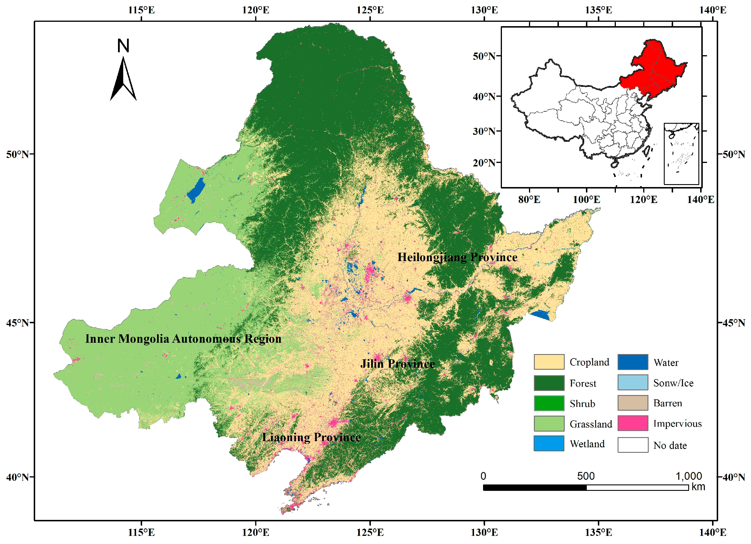
The Northeast region is located in northern China and covers the provinces of Heilongjiang, Jilin, and Liaoning, as well as the four eastern leagues of Inner Mongolia (Figure 1). It is the highest latitude region within China, with a total area of approximately 1.45 million km2. The climate there is characterized by frigid winters, temperate summers, fleeting spring and autumn seasons, a relative scarcity of thermal resources, and an annual precipitation range of 400 to 1000 mm. The region is abundant in natural resources and serves as the primary distribution belt and critical area for forests in China, encompassing 27% of the nation’s total forested land. The dominant forest types include broad-leaved forests, coniferous forests, and mixed coniferous–broadleaved forests. Additionally, it also boasts a diverse array of grassland resources, encompassing meadow grassland, typical grassland, and forest grassland. Notably, meadow grassland exhibits the highest yield of vegetation among temperate natural grasslands in China, with Hulunbeier and Horqin grasslands standing out as two of the most well-preserved exceptional grasslands across Asia and Europe. The exceptional natural resources play an indispensable role in water conservation, soil preservation, and climate warming mitigation, serving as a crucial ecological barrier in the Northeast Asian region [48].
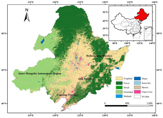
Figure 1.
Location of the study area.
2.2. Data Sources
The dataset employed in this study included land use coverage data, physical geography data, and socio-economic data.
(1) The land use cover data in this study were derived from the Annual China Land Cover Dataset (CLCD), which was developed by a team from Wuhan University using Landsat imagery on Google Earth Engine. The dataset provided detailed information on land cover from 1985 to 2022, and employed a novel classification system comprising nine major land use types: cropland, forest, shrub, grassland, water, snow and ice, barren, impervious surfaces and wetlands. Notably, the CLCD demonstrated an impressive overall accuracy of up to 80% [53]. In this study, according to the research objectives, the land use cover data (excluding construction land) in the Northeast region were extracted and aggregated into six land use types: cropland, forest, grassland, water, wetland, and barren; (2) physical geography data encompassed various parameters, including annual precipitation, average annual temperature, annual sunshine hours, normalized vegetative index (NDVI), net primary productivity (NPP), and transpiration; and (3) socio-economic data comprised indicators such as gross domestic product (GDP), population density, length of highway, and building area. The dataset contains data from 233 districts and counties in Northeast China, and the data formats are all raster data, and the data details are shown in Table 1.

Table 1.
The description of data and data sources.
2.3. Evaluation of ESV and Correction of Its Correlation Coefficient
Xie et al. (2008) calculated the economic value of China’s standard unit-equivalent coefficients based on Costanza’s benefit-transfer method, incorporating modified parameters [15,54]. The equation could be expressed as follows:
where f represents the land cover type, k denotes the ecosystem service function, Ak signifies the area (ha) of different land cover type k, and VCkf is the value of the unit area (ha) for land cover type f in relation to various ecosystem service functions k. The formula for VCkf is
where P and T represents the average market price (CNY/kg) and unit area production (kg/ha) of grain crops, respectively. Based on the actual conditions of the study area, we selected the average market price and unit area production of the Northeast region in 2020, which were 2.19 CNY/kg and 5977.5 kg/ha, respectively. The unit area equivalence coefficient (Ekf) was formulated based on national data.
In order to better match the characteristics of the Northeast region, this paper combines the relevant studies [53] and amends the original equivalence coefficient (Ekf) to establish the ESV coefficient applicable to this study area. The specific parameter correction model is presented in Table 2. Then, the equivalent value of ecosystem services in the Northeast was determined in Table 3.

Table 2.
Parameter correction model of unit area equivalent coefficient (Ekf).

Table 3.
ESV equivalent of the ecosystem service functions in Northeast China.
2.4. Construction of Bayesian Spatio-Temporal Hierarchical Models
2.4.1. Model Building
This study employed a Bayesian spatio-temporal hierarchical model, with the counties in the study area serving as units of analysis. The ESV in Northeast China exhibited significant regional differences due to its vast span. As a discrete counting dataset, it exhibited a higher variance comparison to the mean value, indicating excessive dispersion that contradicts the fundamental assumption of Poisson distribution. The Poisson lognormal model was proposed as a solution to this issue. The model effectively accommodated the highly discrete nature of data by incorporating an error term εit into the joint function to account for its discreteness. The Poisson–Lognormal model was therefore chosen as the benchmark in this study to conduct a comprehensive investigation into the valuation of ecological services. The equations governing this model are presented below:
where yit represents the ESV amount of region i in year t. The constant α was derived from the mean value of ESV for each district and county between 2000 and 2020, representing the ecological service capacity over the study period. Si described the spatial heterogeneity effect associated with region i. β(t) described the overall temporal trend of ESV, where b0t* represented a linear trend and vt represented a stochastic trend. t* = t − tmid denoted the temporal distance relative to the midpoint of the study period. The term ωit(i,t) represented the localized trend of region i during the study period. When b1i > 0, it indicated that the local trend of change in region i exceeded the overall trend. Conversely, when b1i < 0, it signified that the local trend of change in region i was smaller than the overall trend, εit represented the Gaussian noise random error, which was used to characterize the additional fluctuations in the data that were not explained by the model; k denoted the influence coefficient of k factors on ESV in region i.
2.4.2. Parameter Calibration
The prior distributions of the impact coefficients were determined using an uninformative prior model, while the prior distributions of the parameters Si and b1i were determined using the Besag York Mollie (BYM) model. The BYM model seamlessly integrates spatially structured and non-structured random effects through a convolution operation. Among them, the spatial non-structural random effects followed a Gaussian distribution. To represent the spatially structured random effect, we employed a conditional auto-regressive prior and estimate its parameters through the INLA package in R language. In terms of the prior distribution for the time random effects parameter, we employ a first-order auto-regressive model that accounted for the correlation between adjacent time points, denoted as . The Gaussian random variable εit was expressed as . The hyperparametric prior distributions of the variance of all random effects in the model (e.g., , ) were specified as strictly positive semi-Gaussian distributions, following Gelman et al. (2006), with a form of N+∞ (0,10) [58].
2.4.3. Selection of Hot and Cold Spots
The overall spatial effect parameter exp (Si) was computed in this study to quantify the magnitude of ESV in region i relative to the average level α in the study area during the observation period. The hot and cold spots of the ESV spatial distribution are determined based on the value of P (exp(si) > 1|data). Regions with P(exp(si) > 1|data) > 0.8, were identified as hot spots, while regions with P(exp(si) > 1|data) < 0.2 were classified as cold spots; regions with P(exp(si) > 1|data) between 0.2 and 0.8 were categorized as warm spots [59].
2.5. Analysis of Spatio-Temporal Fluctuations in ESV
In short-term fluctuation analyses, it could be anticipated that significant spatio-temporal interactions were not the norm, and the overall spatio-temporal component could capture the most structure of the fluctuations. Consequently, the spatio-temporal interaction component could effectively smooth out tiny noise and capture significant deviations from predictable patterns in both spatial and temporal components. Thus, the prior distribution of μit was expressed as a hybrid model comprising two Gaussian distributions, wherein one accounted for minor unexplained variations while the other captured significant deviations from the overall spatial pattern and temporal trend [60]. This study employed these two types of deviations for the identification of “unstable” regions of ESV fluctuations, referred to as the first and second decision rules, respectively. Hybrid models possessed the ability to yield flexible prior structure when faced with heterogeneity concerns [47]. Spatio-temporal interactions are modeled as follows:
where the weight parameter β = (β, 1 − β) follows the Dirichlet distribution of β∼D (1, 1). Here we defined a positive semi-normal super-prior for the standard deviations τ1 and τ2. We introduced a potential model indicator Mit that follows a multinomial distribution [47]. Mit can take the value of 1 or 2, depending on whether it is modeled with τ1 or τ2. The posterior probability of the second component in each spatio-temporal interaction was computed. This computational process followed a Bayesian inference framework, which integrated prior knowledge and observations to derive uncertainty estimates for each component parameter.
The “unstable” pattern of fluctuations under two rules was characterized in this study by establishing a threshold probability Pcut. The first rule stated that if the fluctuation probability of ecosystem service value pit exceeded the threshold probability pcut by at least one unit, the fluctuation of ESV was deemed “unstable”. In accordance with the second rule, if the average of the three maximum values of the fluctuation probability of ESV pit in the region surpassed the threshold probability pcut, the fluctuation of ESV was also judged to be “unstable”.
3. Results
3.1. Characters of the Total ESV
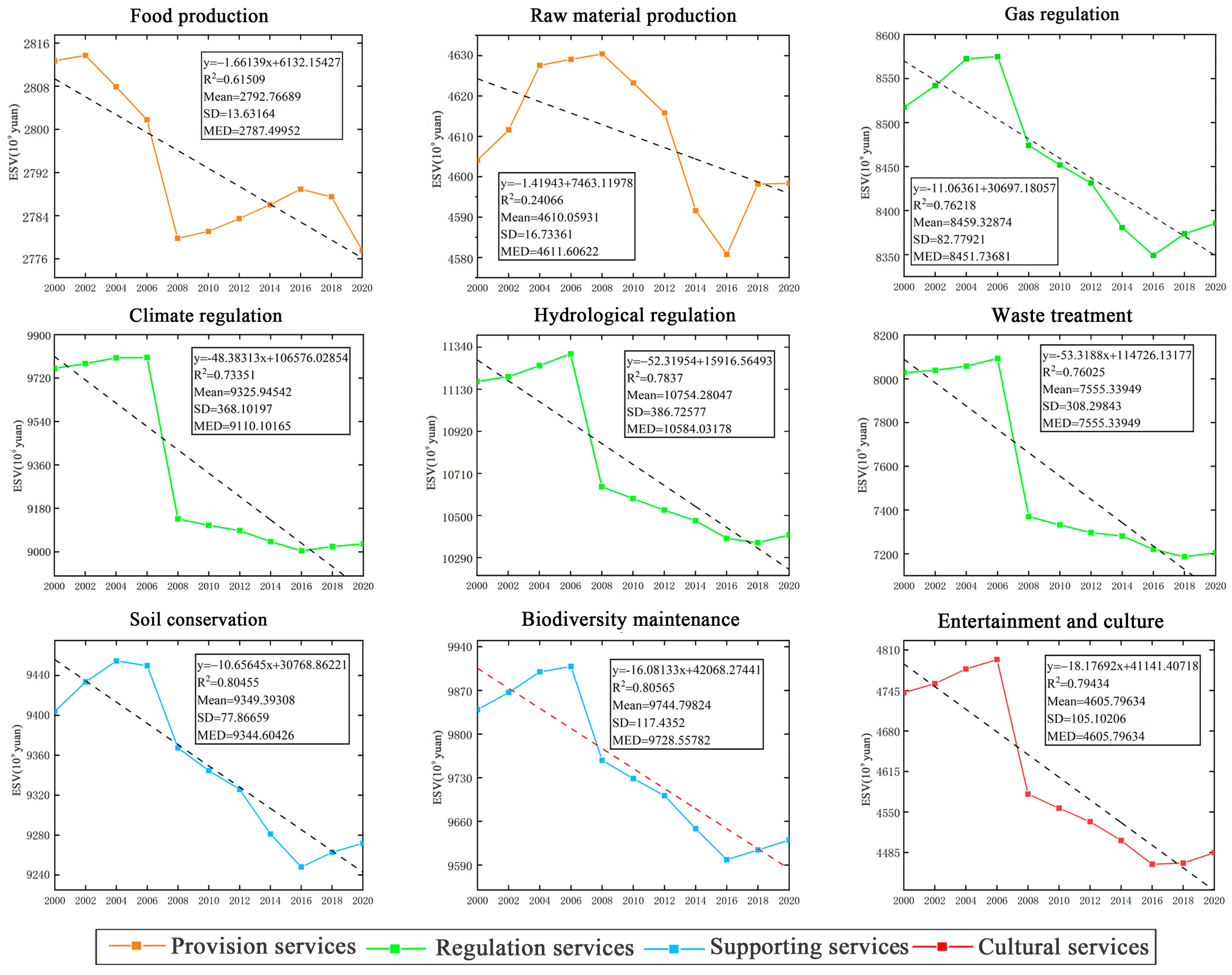
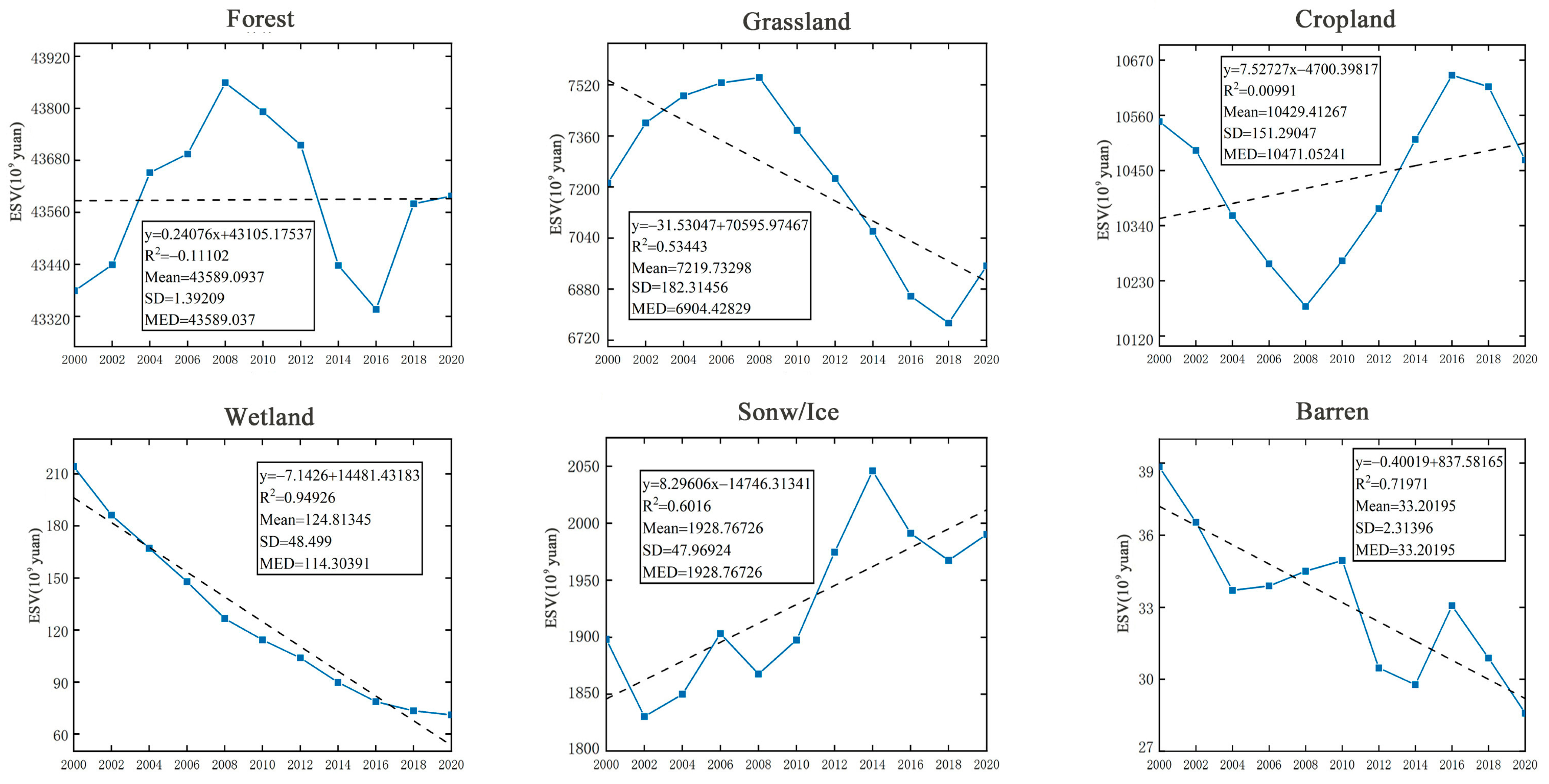
Nine subcategories in provision services, regulatory services, supporting services, and cultural services were quantified, and fitting methodology was employed to identify trends in the Northeast region from 2000 to 2020 (Figure 2). In this case, the solid lines in orange, green, blue, and red represented the respective monetary values associated with provisioning, regulating, supporting, and cultural services. Additionally, the black dashed line depicted a linearly fitted trend. The ESVs under six different land covers were processed in the same way, and the results were illustrated in Figure 3. The solid blue line showed the annual change in ESV for different land uses, and the dashed black line represented the linearly fitted trend.
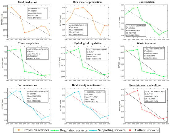
Figure 2.
Monetary value of different ESs.
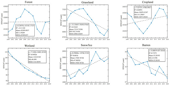
Figure 3.
ESV under different land uses.
From Figure 2, it can be inferred that there were quantitative disparities in the contribution of different types of ESV. Specifically, gas regulation (CNY 837,353–857,476 million), climate regulation (CNY 900,449–980,556 million), hydrologic regulation (CNY 103,6412–113,0638 million), waste treatment (CNY 718,651–809,294 million), soil conservation (CNY 924,800–945,458 million), and biodiversity maintenance (CNY 959,841–990,833 million) contributed more to ESV. In contrast, the ESV contributions of food production (CNY 277,757–281,372 million), raw material production (CNY 458,078–463,039 billion), and entertainment and culture (CNY 446,618–479,451 million) were relatively small. In terms of temporal trends, the ESV of the nine ecological services exhibited a consistent decline throughout the study period. Notably, climate regulation, hydrologic regulation, and waste disposal demonstrated substantial decreases in ESV. Conversely, ESVs for food production and raw material production remained relatively stable.
The information depicted in Figure 3 indicated that the quantitative contribution of ESVs varied significantly among different land use types. In descending order of contribution, it was forest (CNY 4,333,596–4,385,888 million), grassland (CNY 77,396–754,288 million), cropland (CNY 1,017,896–1,063,991 million), wetland (CNY 7102–21,410 million), water (CNY 183,029–204,596 million), and barren (CNY 2859- 3884 million). In terms of temporal trend, the ESV in grassland, wetland, and barren were generally decreasing, while the ESV in waters were generally increasing. However, neither forest (R2 = 0.11102) nor cropland (R2 = 0.00991) exhibited a linear trend in ESV and neither demonstrated any significant overall increase or decrease.
3.2. Spatio-Temporal Heterogeneity of ESVs
3.2.1. Temporal Heterogeneity of ESV
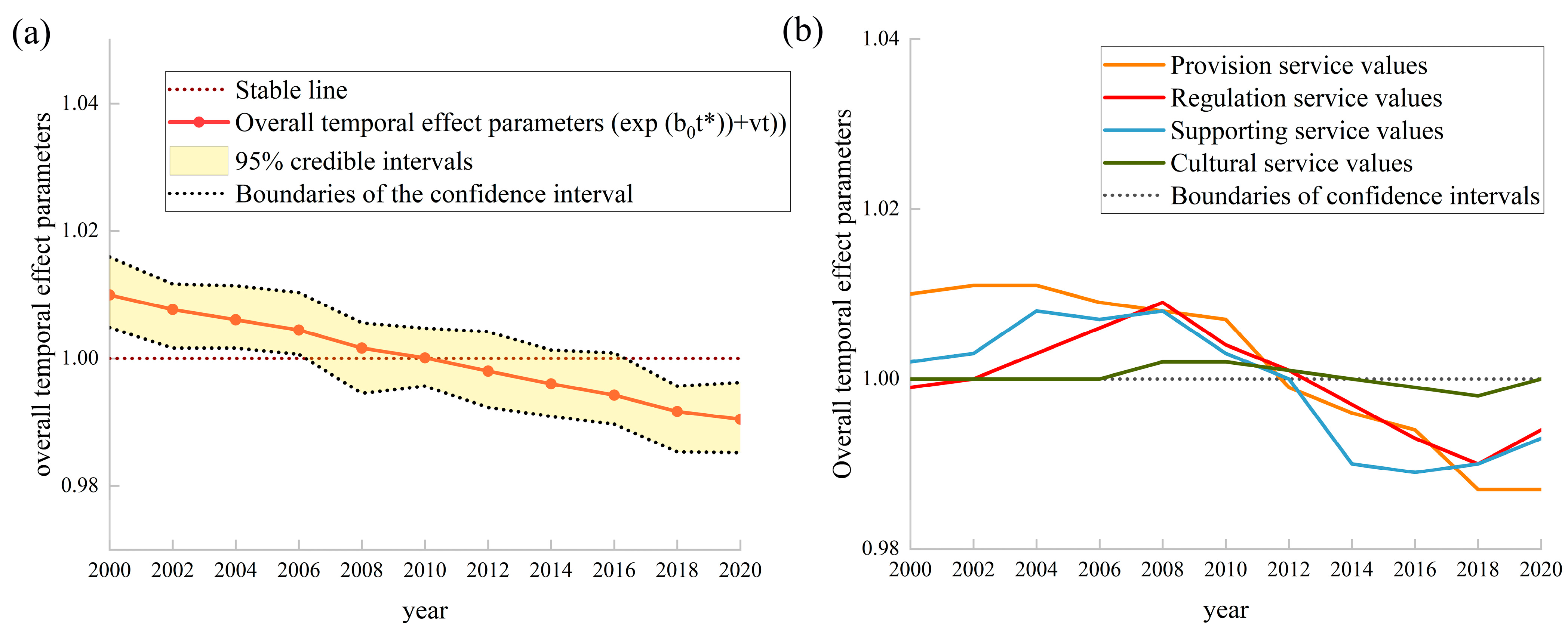
Changes in the posterior probability distribution of ESVs in the northeast region from 2000 to 2020 were shown in Figure 4. The time trend in the value of integrated ESs is depicted in Figure 4a, where the solid red line represents the multi-year average. Additionally, the black dashed line and yellow shaded area indicate the integrated time-trend parameter (exp (b0t* + vt)) and its 95% credible interval, respectively. Figure 4b illustrates the time trend in the value of provision, regulation, supporting, and cultural services.
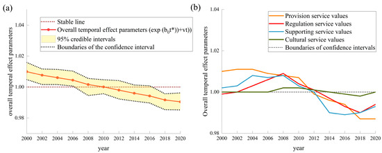
Figure 4.
Overall trend of the temporal variation of the ESVs. (a) is the overall time effect parameter of ecosystem services in 2000 to 2020, and (b) is the time effect parameter of the four Primary categories.
As depicted in Figure 4, a clear overall downward trend in ESV was evident during the period of 2000–2020, with a larger number of districts and counties experiencing a decrease rather than an increase in ESV. The overall time effect parameter (exp (b0t* + vt)) further confirmed this declining trend by revealing the deviation of ESV from the multi-year average on a yearly basis (Figure 4a). However, it should be noted that this decline had not been consistently sustained, as there had been intermittent periods of slow growth in ESV observed in 2002, 2006, and 2008. Additionally, the downward trend exhibited a zigzag pattern based on the analysis of the 95% confidence intervals (Figure 4b), with regulatory services fluctuating the most and cultural services the least.
3.2.2. Spatial Heterogeneity of ESV
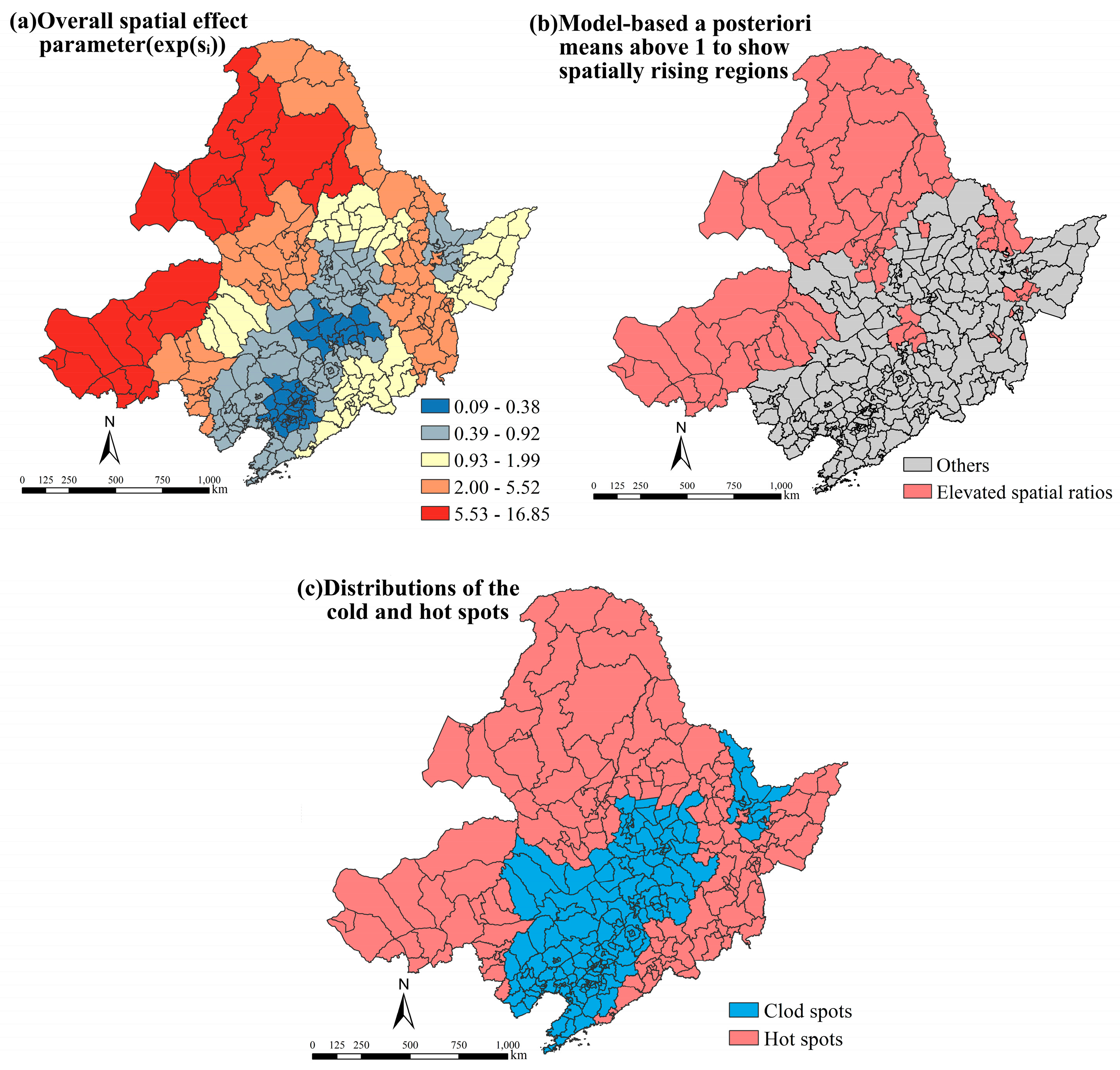
By incorporating the estimated ESVs of the 233 district units in the northeast region into a Bayesian spatio-temporal hierarchical model, we obtained the spatial distribution of the overall spatial effect parameter (exp (Si)) (Figure 5a). Figure 5b shows the districts and counties that were filtered to have ESV values higher than the overall mean in the study area from 2000 to 2020. Figure 5c shows the spatial hot and cold spots of ESV.
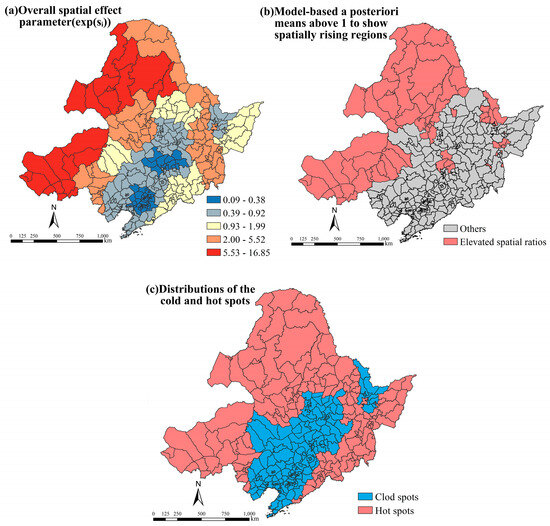
Figure 5.
Spatial heterogeneity of ESV and its distribution patterns of cold and hot spots. (a) is the spatial effect parameter; (b) shows the districts with screened ESV values higher than the overall mean of the study area from 2000 to 2020; and (c) shows the spatial hotspots and coldspots of ESV.
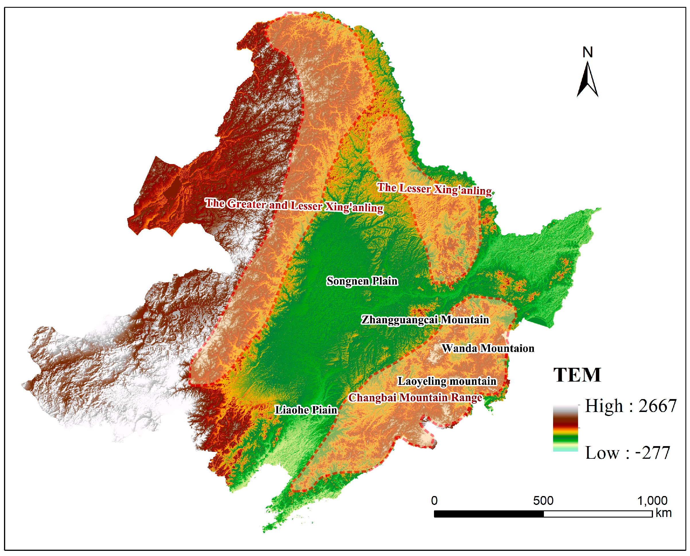
The spatial distribution of ESV in the districts and counties of the study area during 2000–2020 exhibited significant spatial heterogeneity, as depicted in Figure 5. Specifically, ESV was generally higher in the peripheral regions while it was relatively lower in the central region. In terms of interprovincial differences, ESV had the most pronounced spatial effect in Inner Mongolia’s four eastern league regions, closely followed by Greater and Lesser Xing’anling as well as Laoyeling and Wandashan vein regions in Heilongjiagn Province. Comparatively, Shenyang urban agglomeration in central Liaoning Province and Changji urban agglomeration in central Jilin Province exhibited the lowest ESV spatial effects. By comparing the posterior probability (exp(si)) with 1, we identified that 155 districts and counties had ESV values higher than the overall average of the study area, predominantly concentrated in the northwestern region. Meanwhile, there were 178 districts and counties located in gentle terrain areas within eastern and southern parts exhibited ESVs below the overall mean value. In terms of cold–hot spot analysis, a total of 183 hotspot areas were identified, accounting for 54.95% of the total number of units in the study area. These hotspots were primarily concentrated in the peripheral regions of the study area. Correspondingly, there were 150 districts and counties located in cold spot areas, representing 45.05% of the total number of units. These spots were situated across most parts of Liaoning and Jilin Provinces, with sporadic occurrences observed in the northeastern corner of Heilongjiang Province (Figure 6).
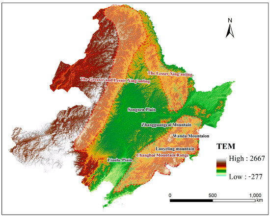
Figure 6.
Topographic and geomorphologic map of the study area.
3.3. Spatio-Temporal Fluctuations in ESV
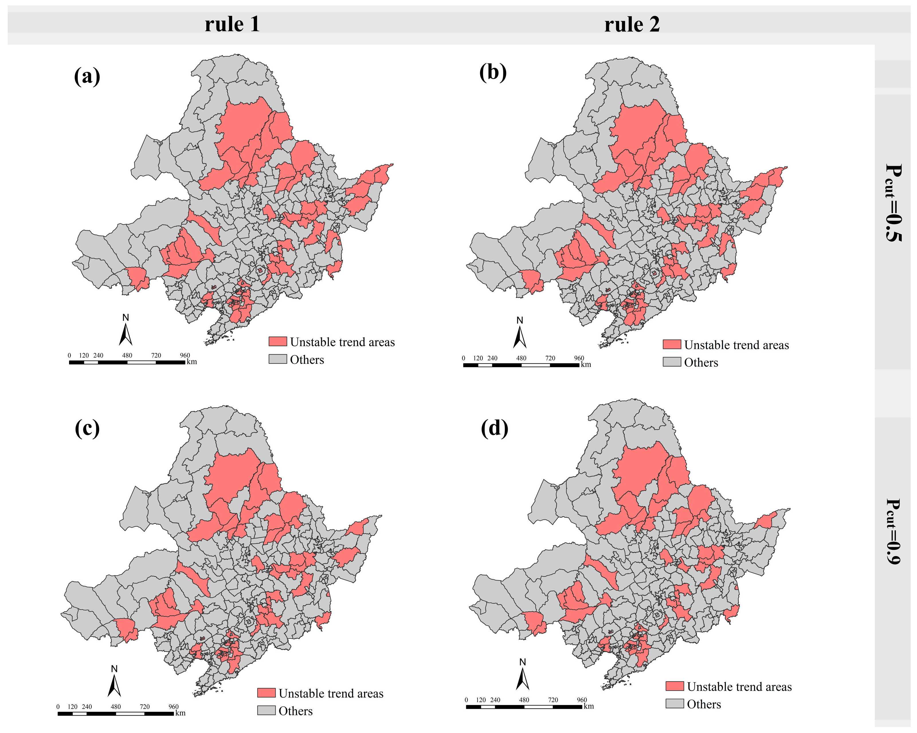
Based on Equation (14) and related studies [47], we rationalize the assignment of the threshold probability Pcut. Specifically, a smaller value of 0.5 and a larger one of 0.9 were rationally chosen to identify unstable regions of spatio-temporal fluctuations of ESV in the study area. The corresponding results were illustrated in Figure 7.
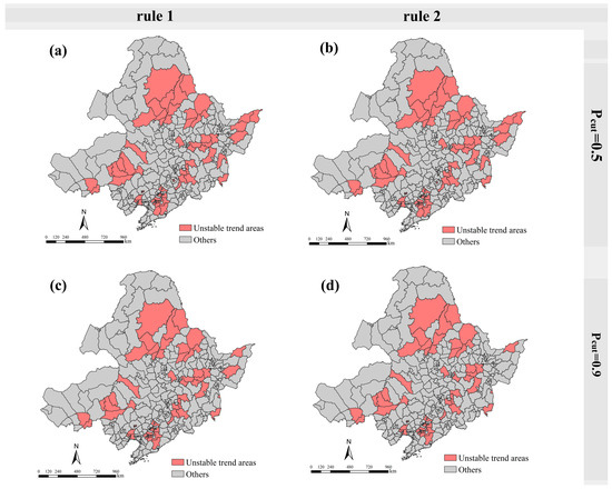
Figure 7.
Identification of unstable regions in the spatial and temporal fluctuations of ESV. (a,b) are the spatial distributions under rule 1 and rule 2 for threshold Pcut = 0.5; (c,d) are the spatial distributions under rule 1 and rule 2 for threshold Pcut = 0.9, respectively.
Regardless of whether the threshold probability pcut was set at 0.5 or 0.9, the unstable areas of spatio-temporal fluctuations of ESV determined by rules 1 and 2 exhibited a high degree of consistency, thereby ensuring the model’s accuracy in delineating regions characterized as “unstable”. When employing a threshold probability pcut of 0.9, there were fewer instances of spatio-temporal fluctuations of ESV classified as “unstable” compared to when using a threshold probability pcut of 0.5, with notable changes primarily concentrated within the Sanjiang Plain. According to Rule 1, we identified 95 “unstable” regions, and in accordance with Rule 2, we picked out 91 “unstable” regions, thereby reinforcing the heightened stringency of Rule 2 compared to Rule 1. From a spatial perspective, the distribution of these “unstable” areas did not exhibit any discernible geographic pattern. Instead, they primarily concentrated within transitional zones spanning from the Great and Small Xing’an Mountains to the Songnen Plain, the Laoye Mountains in south-central Heilongjiang, the north-central region of Sanjiang Plain, agro-pastoral ecotone in middle and southern Inner Mongolia, as well as mountainous regions in southeastern part of Liaoning Province. These specific locations were distinctly characterized by their transition from low hills to plains, marked by significant anthropogenic disturbances and compromised ecosystem stability.
3.4. Influence of ESV Drivers under the Model
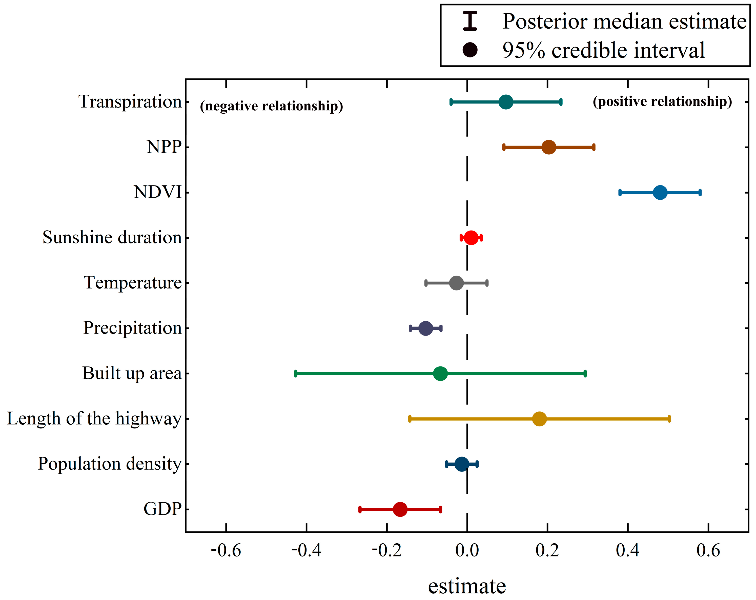
In order to comprehensively analyze the impact of drivers on the spatio-temporal fluctuations of ESV, both anthropogenic and natural drivers were incorporated as covariates in this spatio-temporal hierarchical model for each region. Figure 8 presented the estimated effects of these ten covariates. The Bayesian spatio-temporal hierarchical model yielded posterior median values for the 10 influences. The Gelman–Rubin statistical parameters of these influences were all close to 1, indicating excellent convergence. Further analysis revealed a negative correlation between GDP, population density, floor area, annual precipitation and average annual temperature with ESV; conversely, length of the highway, sunshine duration, NDVI, NPP and transpiration exhibited a positive correlation with ESV. Specifically, an increase in GDP, population density, floor space, annual precipitation, and average annual temperature was associated with a decrease in ESV by 0.16 (95% CI: −0.21, −0.13), 0.01 (95% CI: −0.03, 0.00), 0.07 (95% CI: −0.21, 0.88), 0.1 (95% CI: −0.12, −0.09) and 0.02 (95% CI: −0.06, 0.00) units. Conversely, for every increase in highway length, sunshine hours, NDVI, NPP, and transpiration, the probability of ESV growth increased by 0.18 (95% CI: 0.05, 031), 0.01 (95% CI: 0.00, 0.02), 0.48 (95% CI: 0.44, 0.52), 0.2 (95% CI: 0.16, 0.25) and 0.07 (95% CI: 0.06, 0.16) units.
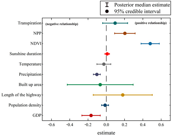
Figure 8.
Bayesian estimation results of influencing factors.
4. Discussion
4.1. Spatio-Temporal Heterogeneity of ESV
By applying a Bayesian spatio-temporal hierarchical model, this paper presented a comprehensive analysis of the spatio-temporal dynamics of ESV in the Northeast region. The findings revealed substantial heterogeneity in these values across space and time, which was consistent with previous findings [23,25], thereby validating the precision and reliability of our constructed spatio-temporal hierarchical model. From a time-series perspective, the total amount of ESV in the northeast region exhibited a declining trend, falling from CNY 559,524 million in 2000 to CNY 558,565 million in 2020. This represents a total decrease of CNY 7459 million over two decades, or an average annual reduction of about CNY 370 million. The primary driver behind this transformation could be attributed to the depletion of eight crucial ecosystem services: food production, gas regulation, climate regulation, hydrological regulation, waste disposal, soil conservation, maintenance of biodiversity, and provision of entertainment and culture [25,61]. However, it was important to note that the decline in ESV exhibited fluctuations rather than a continuous and homogeneous pattern. These fluctuations were mainly due to the declining trend in forest and grassland areas after a period of growth, while changes in farmland area had also contributed to variations in ESV [57,62]. From the perspective of spatial variability, ESV hotspot areas were mainly concentrated in the Greater and Small Xing’an Mountains, Changbai Mountains, Laoyeling and Wundashan Veins, as well as the Inner Mongolia territory in the northwestern part of the study area. These regions had high terrain and were rich in forests, grasslands and wetlands, which contributed significantly to increased ESV [26,63]. In the northwestern part of the study area, there was a gradual and persistent increase in ESV, exceeding the average ESV observed across the whole study area. Conversely, cold spots of ESV were predominantly concentrated in the central region, characterized by gentle terrain, which served as a primary distribution hub for major cities and populations within the provinces. These regions exhibited lower than average ESV due to increased urban land use expansion and intensification of farmland, resulting in a declining trend in ESV [64].
4.2. Drivers of ESV
ESs are affected by both natural environment and anthropogenic activities [29,31]. In this study, natural and anthropogenic factors were included as covariates in the analysis by integrating the spatio-temporal hierarchical model to accurately represent the spatial effects of ESV in each district and county [47]. The results of the study showed that there was a significant positive correlation between natural factors such as NDVI, NPP and ESV, highlighting their important role in the provision of ecological services. On the contrary, anthropogenic factors such as population density and GDP showed a strong negative correlation with ESV, suggesting that while pursuing economic growth, we need to properly balance the relationship with the value of ecological services in order to achieve sustainable development. How to scientifically quantify the relationship between economic indicators represented by GDP and ESV has become a hot topic in current research [33,65]. In addition, the correlation between other variables and ESV was found to be insignificant in this study. Given the complex and variable spatial and temporal distribution of regional ESV, it is often difficult for a single indicator to comprehensively reveal its dynamic pattern of change, so it is necessary to further refine the assessment indicators. For example, indicators such as building area and road length should receive more attention in future studies as they exhibit a large range of fluctuation.
4.3. Detection Method for the ESV Spatio-Temporal Pattern
Traditional spatial data analysis at the regional level generally uses probabilistic statistical methods for cluster analysis and identification of hot and cold spots, or analyzes influencing factors through some spatial econometric models. However, in spatial econometric models of probabilistic statistics, the regression parameters are generally regarded as fixed, while in reality, these are uncertain and non-fixed [58,66]. Traditional probabilistic statistical models cannot systematically analyze the available information and the form of the model is more restricted because the fitted probabilistic model must be easy to solve [67]. At the same time, the explanatory variables in traditional probabilistic statistical models are generally required to be continuous, non-counting, and to follow a normal distribution. In contrast to traditional probability statistics, the Bayesian approach treats the parameters as random variables and obeys a certain form of distribution, and the data can be discrete, obeying Poisson, Bernoulli distributions, and so on [42,43]. Through the hierarchical structure, Bayesian methods can incorporate temporal, spatial and temporal interaction information into a model and estimate it through simulation [68,69].
In the constructed model, the overall spatial effect parameter exp (Si) directly reflects the extent of provincial ESV relative to the overall level, further identifying hot and cold spots in the spatial distribution. The overall time effect parameter (exp (β0t* + vt)) is used to better understand the trend of ESV for each year relative to the multi-year average, while the spatio-temporal effect quantity is utilized to determine the spatio-temporal volatility of ESV. The correlation parameter (exp (βn)) of the post-test estimation suggests that anthropogenic drivers have a positive or negative effect on ESV and confirms its significance by incorporating the nature of the parameter values within the 95% CI [43,70]. Thus, a multi-task integrated analysis of spatio-temporal patterns and exploratory variables was realized [71]. Overall, the Bayesian spatio-temporal hierarchical model is more advantageous than the traditional analysis methods in terms of applicability and flexibility.
4.4. Policy Implications
Reconciling ecosystem conservation and socio-economic development to achieve sustainable development has been a focus for policy makers around the world. Many studies have attempted to address this challenge by directly designating ecosystem service hotspots as ecological reserves [72,73]. While this approach provides some relief for natural ecosystems, it does not take into account the variability of management responses across heterogeneous units. Therefore, exploring the characteristics of spatio-temporal heterogeneity of ecosystem services may provide more rational recommendations for sustainable development [74]. Over the past 20 years, the value of ecosystem services in Northeast China has shown a fluctuating downward trend. From the cold hotspot analyses in this paper, it can be drawn that hotspot areas are mainly concentrated in areas rich in natural resources such as forests, grasslands and wetlands, which play an important role in providing ESV. However, the stability analysis shows that these regions are also clustered in some areas with strong ESV fluctuations. They are located in the transition zone from slopes to plains, where anthropogenic disturbances are relatively intense and irrational land use development activities, such as agricultural reclamation and rapid expansion of urban land use, exacerbate the fragmentation of ecological landscapes, such as forests, and the degradation of habitat quality, resulting in the decline of locally important ecological functions. Obviously, it is impossible to protect all natural ecological space, but it is necessary to protect important ecological space and natural ecological security boundaries by drawing ecological protection red lines [75]. Therefore, strengthening the protection of ecosystems and enhancing the supervision of human activities around the construction of the ecological protection red line and the system of nature reserves is an important basis for protecting the core area of ecological security and safeguarding the boundary of natural ecological security. In addition, for cold spot areas, regional ecological functions should be moderately improved. For example, in areas with poor ecological conditions, the intensity of land development should be strictly limited, new impervious surfaces should be limited, and the layout of green spaces should be optimized. These measures help to improve ecological carrying capacity by regulating the water cycle, increasing carbon sequestration, promoting climate regulation, and providing habitats for certain organisms [76].
4.5. Limitations and Outlook
The dynamics of ESV are an extremely complex issue, but they also tend to exhibit striking regularity and predictability, as has been confirmed by a large number of studies [29,71]. There are complex dependencies in the spatio-temporal distribution of ESV, which are particularly evident in certain regions. In this study, we take full advantage of Bayesian hierarchical modeling to explore in depth the “predictable pattern” of LUCC-based ESV fluctuations by integrating the joint mixture of spatio-temporally interacting components. We use the overall temporal effect parameter (exp (bot* + vt)) to better understand the tendency of ESV to deviate from the multi-year average in each year. In addition, we identify the effect of anthropogenic drivers on the ESV using the posteriorly estimated correlation parameter (exp (βn)) confirm its significance on the ESV over time and space in relation to the nature of the parameter values within the 95% CI, a result consistent with the findings of references [70,71]. The experiments show that the results of the Bayesian spatio-temporal model can meet the needs of ESV spatio-temporal heterogeneity analysis. The covariates should be further optimized and the effects of multiple influencing factors on ESV spatio-temporal can be assessed. The hybrid component uses a flexible a priori structure that achieves a separation between small unexplained variability and “true” substantial deviations from predictable patterns based on spatio-temporal main effects, as further demonstrated in reference [24]. Nevertheless, there is still room for improvement in the method in regional applications. First, a finer classification of land use types would help to improve the accuracy of ESV assessment and deepen our understanding of different ESVs. Second, although it is mathematically feasible to incorporate explanatory variables into Bayesian spatio-temporal models, this does not adequately explain the intricate process of ecosystem evolution. For long-term continuous studies on the spatio-temporal heterogeneity of ESVs, the impacts of explanatory variables may encompass pure space, pure time, or both. Therefore, the effects of explanatory variables on the spatio-temporal heterogeneity of ESVs in the temporal dimension, the spatial dimension and the integrated spatio-temporal dimension need to be further investigated in depth.
5. Conclusions
In this study, we estimated the ecological service value (ESV) in Northeast China from 2000 to 2020 based on a 30 m annual land use cover dataset, and explored the spatio-temporal heterogeneity of the ESV, hot and cold spots, and unstable regions of spatial and temporal variability by constructing a Bayesian spatio-temporal hierarchical model using the spatial effect parameter exp (Si) and the posterior probability that the spatial effects parameter exp (Si) is greater than 1, i.e., P(exp(si) > 1|data). The main conclusions of the study are as follows:
- (1)
- From 2000 to 2020, the total ESV in the study area shows a decreasing trend, decreasing from CNY 559,524 million in 2000 to CNY 558,565 million in 2020, with a total decrease of CNY 7459 million in 20 years, averaging about CNY 370 million per year. The uneven decrease in forests, grasslands and farmlands is the main reason of the unevenly fluctuating decline of ESV;
- (2)
- The spatial distribution of ESV is significantly heterogeneous, with hotspots mainly concentrated in areas with high terrain and rich forest, grassland and wetland resources, while cold spots are mainly distributed in urban agglomerations with gentle terrain and intense anthropogenic interference. The transition zone from low hills to plains is an “unstable zone” for spatial and temporal fluctuations of ESV due to poor ecosystem stability;
- (3)
- Both the ecological environment and human activities have a strong influence on ESV. Among them, there is a significant positive correlation between NDVI, NPP and ESV, while anthropogenic factors such as population density and GDP show a strong negative correlation with ESV. Therefore, strengthening the protection of ecosystems such as forests, grasslands and wetlands, rationally configuring the intensity and layout of human activities, and promoting the coordinated development of human economic activities and ecological protection are necessary ways for the sustainable development of the study area.
Author Contributions
Conceptualization, F.G. and J.S.; methodology, J.S. and J.L.; software, J.S. and J.L.; resources, X.Z. and X.C.; data curation, Y.S.; writing—original draft preparation, J.S. and J.L.; writing—review and editing, F.G.; visualization, J.S.; supervision, J.L. All authors have read and agreed to the published version of the manuscript.
Funding
This research was funded by National Natural Science Foundation of China (U21A20238) and Heilongjiang Provincial Key Laboratory of Soil Protection and Remediation.
Data Availability Statement
The data presented in this study are available on request from the corresponding author. The data are not publicly available due to the ongoing nature of the research.
Acknowledgments
We thank our colleagues for their insightful comments on an earlier version of this manuscript.
Conflicts of Interest
The authors declare no conflicts of interest.
References
- Costanza, R.; De Groot, R.; Braat, L.; Kubiszewski, I.; Fioramonti, L.; Sutton, P.; Farber, S.; Grasso, M. Twenty years of ecosystem services: How far have we come and how far do we still need to go? Ecosyst. Serv. 2017, 28, 1–16. [Google Scholar] [CrossRef]
- Tan, P.Y.; Zhang, J.; Masoudi, M.; Alemu, J.B.; Edwards, P.J.; Grêt-Regamey, A.; Richards, D.R.; Saunders, J.; Song, X.P.; Wong, L.W. A conceptual framework to untangle the concept of urban ecosystem services. Landsc. Urban Plan. 2020, 200, 103837. [Google Scholar] [CrossRef] [PubMed]
- Kumar, M.; Kumar, P. Valuation of the ecosystem services: A psycho-cultural perspective. Ecol. Econ. 2008, 64, 808–819. [Google Scholar] [CrossRef]
- Raymond, C.M.; Singh, G.G.; Benessaiah, K.; Bernhardt, J.R.; Levine, J.; Nelson, H.; Turner, N.J.; Norton, B.; Tam, J.; Chan, K.M.A. Ecosystem Services and Beyond: Using Multiple Metaphors to Understand Human–Environment Relationships. BioScience 2013, 63, 536–546. [Google Scholar] [CrossRef]
- Bennett, E.M.; Cramer, W.; Begossi, A.; Cundill, G.; Díaz, S.; Egoh, B.N.; Geijzendorffer, I.R.; Krug, C.B.; Lavorel, S.; Lazos, E.; et al. Woodward Linking biodiversity, ecosystem services, and human well-being: Three challenges for designing research for sustainability. Curr. Opin. Environ. Sustain. 2015, 14, 76–85. [Google Scholar] [CrossRef]
- Heckwolf, M.J.; Peterson, A.; Janes, H.; Horne, P.; Kuenne, J.; Liversage, K.; Sajeva, M.; Reusch, T.B.H.; Kotta, J. From ecosystems to socio-economic benefits: A systematic review of coastal ecosystem services in the Baltic Sea. Sci. Total Environ. 2021, 755, 142565. [Google Scholar] [CrossRef] [PubMed]
- Portman, M.E. Ecosystem services in practice: Challenges to real world implementation of ecosystem services across multiple landscapes—A critical review. Appl. Geogr. 2013, 45, 185–192. [Google Scholar] [CrossRef]
- Hasan, S.S.; Zhen, L.; Miah, M.G.; Ahamed, T.; Samie, A. Impact of land use change on ecosystem services: A review. Environ. Dev. 2020, 34, 100527. [Google Scholar] [CrossRef]
- Stuart, S.N.; Chanson, J.S.; Cox, N.A.; Young, B.E.; Rodrigues, A.S.L.; Fischman, D.L.; Waller, R.W. Status and Trends of Amphibian Declines and Extinctions Worldwide. Science 2004, 306, 1783–1786. [Google Scholar] [CrossRef]
- Adla, K.; Dejan, K.; Neira, D.; Dragana, Š. Degradation of ecosystems and loss of ecosystem services. In One Health; Elsevier: Amsterdam, The Netherlands, 2022; pp. 281–327. [Google Scholar]
- Mondal, S.; Palit, D. Challenges in natural resource management for ecological sustainability. In Natural Resources Conservation and Advances for Sustainability; Elsevier: Amsterdam, The Netherlands, 2022; pp. 29–59. [Google Scholar]
- Millennium Ecosystem Assessment. Ecosystems and Human Well-Being; Island Press: Washington, DC, USA, 2005; Volume 5. [Google Scholar]
- Walther, G.-R.; Post, E.; Convey, P.; Menzel, A.; Parmesan, C.; Beebee, T.J.C.; Fromentin, J.-M.; Hoegh-Guldberg, O.; Bairlein, F. Ecological responses to recent climate change. Nature 2002, 416, 389–395. [Google Scholar] [CrossRef]
- Ekka, P.; Patra, S.; Upreti, M.; Kumar, G.; Kumar, A.; Saikia, P. Land Degradation and its impacts on Biodiversity and Ecosystem services. Land Environ. Manag. Through For. 2023, 77–101. [Google Scholar] [CrossRef]
- Costanza, R.; d’Arge, R.; de Groot, R.; Farber, S.; Grasso, M.; Hannon, B.; Limburg, K.; Naeem, S.; O’Neill, R.V.; Paruelo, J.; et al. The value of the world’s ecosystem services and natural capital. Nature 1997, 387, 253–260. [Google Scholar] [CrossRef]
- Gómez-Baggethun, E.; Ruiz-Pérez, M. Economic valuation and the commodification of ecosystem services. Prog. Phys. Geogr. 2011, 35, 613–628. [Google Scholar] [CrossRef]
- Schägner, J.P.; Brander, L.; Maes, J.; Hartje, V. Mapping ecosystem services’ values: Current practice and future prospects. Ecosyst. Serv. 2013, 4, 33–46. [Google Scholar] [CrossRef]
- Fairhead, J.; Leach, M.; Scoones, I. Green grabbing: A new appropriation of nature? In Green Grabbing: A New Appropriation of Nature; Routledge: London, UK, 2014; pp. 11–36. [Google Scholar]
- Blanco, J.; Dendoncker, N.; Barnaud, C.; Sirami, C. Ecosystem disservices matter: Towards their systematic integration within ecosystem service research and policy. Ecosyst. Serv. 2019, 36, 100913. [Google Scholar] [CrossRef]
- Bagstad, K.J.; Semmens, D.J.; Waage, S.; Winthrop, R. A comparative assessment of decision-support tools for ecosystem services quantification and valuation. Ecosyst. Serv. 2013, 5, 27–39. [Google Scholar] [CrossRef]
- Braat, L.C.; De Groot, R. The ecosystem services agenda: Bridging the worlds of natural science and economics, conservation and development, and public and private policy. Ecosyst. Serv. 2012, 1, 4–15. [Google Scholar] [CrossRef]
- Laurans, Y.; Rankovic, A.; Billé, R.; Pirard, R.; Mermet, L. Use of ecosystem services economic valuation for decision making: Questioning a literature blindspot. J. Environ. Manag. 2013, 119, 208–219. [Google Scholar] [CrossRef]
- Xie, G.; Zhang, C.; Zhen, L.; Zhang, L. Dynamic changes in the value of China’s ecosystem services. Ecosyst. Serv. 2017, 26, 146–154. [Google Scholar] [CrossRef]
- Li, J.; Chen, H.; Zhang, C.; Pan, T. Variations in ecosystem service value in response to land use/land cover changes in Central Asia from 1995–2035. PeerJ 2019, 7, e7665. [Google Scholar] [CrossRef]
- Yang, J.; Xie, B.; Zhang, D. Spatial–temporal evolution of ESV and its response to land use change in the Yellow River Basin, China. Sci. Rep. 2022, 12, 1–10. [Google Scholar] [CrossRef] [PubMed]
- Gao, F.; Cui, J.; Zhang, S.; Xin, X.; Zhang, S.; Zhou, J.; Zhang, Y. Spatio-Temporal Distribution and Driving Factors of Ecosystem Service Value in a Fragile Hilly Area of North China. Land 2022, 11, 2242. [Google Scholar] [CrossRef]
- De Groot, R.; Brander, L.; Van Der Ploeg, S.; Costanza, R.; Bernard, F.; Braat, L.; Christie, M.; Crossman, N.; Ghermandi, A.; Hein, L.; et al. Global estimates of the value of ecosystems and their services in monetary units. Ecosyst. Serv. 2012, 1, 50–61. [Google Scholar] [CrossRef]
- Peng, K.; Jiang, W.; Ling, Z.; Hou, P.; Deng, Y. Evaluating the potential impacts of land use changes on ecosystem service value under multiple scenarios in support of SDG reporting: A case study of the Wuhan urban agglomeration. J. Clean. Prod. 2021, 307, 127321. [Google Scholar] [CrossRef]
- Kindu, M.; Schneider, T.; Teketay, D.; Knoke, T. Changes of ecosystem service values in response to land use/land cover dynamics in Munessa–Shashemene landscape of the Ethiopian highlands. Sci. Total Environ. 2016, 547, 137–147. [Google Scholar] [CrossRef] [PubMed]
- Nan, B.; Yang, Z.; Bi, X.; Fu, Q.; Li, B. Spatial-temporal correlation analysis of ecosystem services value and human activities—A case study of Huayang Lakes area in the middle reaches of Yangtze River. China Environ. Sci. 2018, 38, 3531–3541. [Google Scholar]
- Liu, Z.; Wu, R.; Chen, Y.; Fang, C.; Wang, S. Factors of ecosystem service values in a fast-developing region in China: Insights from the joint impacts of human activities and natural conditions. J. Clean. Prod. 2021, 297, 126588. [Google Scholar] [CrossRef]
- Li, L.; Tang, H.; Lei, J.; Song, X. Spatial autocorrelation in land use type and ecosystem service value in Hainan Tropical Rain Forest National Park. Ecol. Indic. 2022, 137, 108727. [Google Scholar] [CrossRef]
- Li, G.; Fang, C.; Wang, S. Exploring spatiotemporal changes in ecosystem-service values and hotspots in China. Sci. Total Environ. 2016, 545–546, 609–620. [Google Scholar] [CrossRef]
- Hu, M.; Li, Z.; Wang, Y.; Jiao, M.; Li, M.; Xia, B. Spatio-temporal changes in ecosystem service value in response to land-use/cover changes in the Pearl River Delta. Resour. Conserv. Recycl. 2019, 149, 106–114. [Google Scholar] [CrossRef]
- Song, C.; He, Y.; Bo, Y.; Wang, J.; Ren, Z.; Yang, H. Risk Assessment and Mapping of Hand, Foot, and Mouth Disease at the County Level in Mainland China Using Spatiotemporal Zero-Inflated Bayesian Hierarchical Models. Int. J. Environ. Res. Public Health 2018, 15, 1476. [Google Scholar] [CrossRef]
- Wang, Y.; Lai, Y.; Du, Z.; Zhang, W.; Feng, C.; Li, R.; Hao, Y. Spatiotemporal distribution of hand, foot, and mouth disease in Guangdong Province, China and potential predictors, 2009–2012. Int. J. Environ. Res. Public Health 2019, 16, 1191. [Google Scholar] [CrossRef] [PubMed]
- Zhang, J.; Feng, Z.; Yang, C. Study on establishment and application of multiscale joint analysis model based on hierarchical Bayesian spatiotemporal model. Chin. J. Health Stat. 2013, 30, 199–203. [Google Scholar]
- Bekara, M.; Azizi, L.; Bénet, J.J.; Durand, B. Spatial-temporal Variations of Bovine Tuberculosis Incidence in F rance between 1965 and 2000. Transbound. Emerg. Dis. 2016, 63, 101–113. [Google Scholar] [CrossRef]
- Vanem, E.; Huseby, A.B.; Natvig, B. A Bayesian hierarchical spatio-temporal model for significant wave height in the North Atlantic. Stoch. Environ. Res. Risk Assess. 2012, 26, 609–632. [Google Scholar] [CrossRef]
- Han, X.; Li, J.; Wang, N. Spatiotemporal evolution of Chinese ageing from 1992 to 2015 based on an improved Bayesian space-time model. BMC Public Health 2018, 18, 502. [Google Scholar] [CrossRef]
- Bernardinelli, L.; Clayton, D.; Pascutto, C.; Montomoli, C.; Ghislandi, M.; Songini, M. Bayesian analysis of space—Time variation in disease risk. Stat. Med. 1995, 14, 2433–2443. [Google Scholar] [CrossRef]
- Li, G.; Haining, R.; Richardson, S.; Best, N. Space–time variability in burglary risk: A Bayesian spatio-temporal modelling approach. Spat. Stat. 2014, 9, 180–191. [Google Scholar] [CrossRef]
- Yang, R.; Ren, F.; Xu, W.; Ma, X.; Zhang, H.; He, W. China’s ecosystem service value in 1992–2018: Pattern and anthropogenic driving factors detection using Bayesian spatiotemporal hierarchy model. J. Environ. Manag. 2022, 302, 114089. [Google Scholar] [CrossRef]
- Song, C.; Yang, X.; Shi, X.; Bo, Y.; Wang, J. Estimating missing values in China’s official socioeconomic statistics using progressive spatiotemporal Bayesian hierarchical modeling. Sci. Rep. 2018, 8, 10055. [Google Scholar] [CrossRef]
- Kleinschmidt, I.; Sharp, B.; Mueller, I.; Vounatsou, P. Rise in malaria incidence rates in South Africa: A small-area spatial analysis of variation in time trends. Am. J. Epidemiol. 2002, 155, 257–264. [Google Scholar] [CrossRef] [PubMed]
- Aguero-Valverde, J.; Jovanis, P.P. Spatial analysis of fatal and injury crashes in Pennsylvania. Accid. Anal. Prev. 2006, 38, 618–625. [Google Scholar] [CrossRef] [PubMed]
- Wang, Z.; Yue, Y.; He, B.; Nie, K.; Tu, W.; Du, Q.; Li, Q. A Bayesian spatio-temporal model to analyzing the stability of patterns of population distribution in an urban space using mobile phone data. Int. J. Geogr. Inf. Sci. 2021, 35, 116–134. [Google Scholar] [CrossRef]
- Yu, C.; Liu, D.; Feng, R.; Tang, Q.; Guo, C. Construction of ecological security pattern in Northeast China based on MCR model. Acta Ecol. Sin. 2021, 41, 290–301. [Google Scholar]
- Zhu, G.; Tang, Z.; Shangguan, Z.; Peng, C.; Deng, L. Factors Affecting the Spatial and Temporal Variations in Soil Erodibility of China. J. Geophys. Res. Earth Surf. 2019, 124, 737–749. [Google Scholar] [CrossRef]
- Mao, D.; Wang, Z.; Wu, J.; Wu, B.; Zeng, Y.; Song, K.; Yi, K.; Luo, L. China’s wetlands loss to urban expansion. Land Degrad. Dev. 2018, 29, 2644–2657. [Google Scholar] [CrossRef]
- Du, H.; Liu, J.; Li, M.H.; Büntgen, U.; Yang, Y.; Wang, L.; Wu, Z.; He, H.S. Warming-induced upward migration of the alpine treeline in the Changbai Mountains, northeast China. Glob. Chang. Biol. 2018, 24, 1256–1266. [Google Scholar] [CrossRef]
- Liang, C.; Michalk, D.L.; Millar, G.D. The ecology and growth patterns of Cleistogenes species in degraded grasslands of eastern Inner Mongolia, China. J. Appl. Ecol. 2002, 39, 584–594. [Google Scholar] [CrossRef]
- Liu, Y.; Yuan, X.; Li, J.; Qian, K.; Yan, W.; Yang, X.; Ma, X. Trade-offs and synergistic relationships of ecosystem services under land use change in Xinjiang from 1990 to 2020: A Bayesian network analysis. Sci. Total Environ. 2023, 858, 160015. [Google Scholar] [CrossRef]
- Xie, G.-d.; Zhen, L.; Lu, C.-X.; Xiao, Y.; Chen, C. Expert knowledge based valuation method of ecosystem services in China. J. Nat. Resour. 2008, 23, 911–919. [Google Scholar]
- Bian, Z.; Lu, Q. Ecological effects analysis of land use change in coal mining area based on ecosystem service valuing: A case study in Jiawang. Environ. Earth Sci. 2012, 68, 1619–1630. [Google Scholar] [CrossRef]
- Wei, Y.; Huang, C.; Li, J.; Xie, L. An evaluation model for urban carrying capacity: A case study of China’s mega-cities. Habitat Int. 2016, 53, 87–96. [Google Scholar] [CrossRef]
- Long, H.; Liu, Y.; Hou, X.; Li, T.; Li, Y. Effects of land use transitions due to rapid urbanization on ecosystem services: Implications for urban planning in the new developing area of China. Habitat Int. 2014, 44, 536–544. [Google Scholar] [CrossRef]
- Gelman, A. Prior distributions for variance parameters in hierarchical models (comment on article by Browne and Draper). Bayesian Anal. 2006, 1, 515–534. [Google Scholar] [CrossRef]
- Richardson, S.; Thomson, A.; Best, N.; Elliott, P. Interpreting posterior relative risk estimates in disease-mapping studies. Environ. Health Perspect. 2004, 112, 1016–1025. [Google Scholar] [CrossRef] [PubMed]
- Abellan, J.J.; Richardson, S.; Best, N. Use of Space–Time Models to Investigate the Stability of Patterns of Disease. Environ. Health Perspect. 2008, 116, 1111–1119. [Google Scholar] [CrossRef] [PubMed]
- Yan, F.; Zhang, S. Ecosystem service decline in response to wetland loss in the Sanjiang Plain, Northeast China. Ecol. Eng. 2019, 130, 117–121. [Google Scholar] [CrossRef]
- Jin, G.; Chen, K.; Liao, T.; Zhang, L.; Najmuddin, O. Measuring ecosystem services based on government intentions for future land use in Hubei Province: Implications for sustainable landscape management. Landsc. Ecol. 2020, 36, 2025–2042. [Google Scholar] [CrossRef]
- Ling, H.; Yan, J.; Xu, H.; Guo, B.; Zhang, Q. Estimates of shifts in ecosystem service values due to changes in key factors in the Manas River basin, northwest China. Sci. Total Environ. 2018, 659, 177–187. [Google Scholar] [CrossRef]
- Huang, Z.; Chen, Y.; Zheng, Z.; Wu, Z. Spatiotemporal coupling analysis between human footprint and ecosystem service value in the highly urbanized Pearl River Delta urban Agglomeration, China. Ecol. Indic. 2023, 148. [Google Scholar] [CrossRef]
- Zhang, Z.; Xia, F.; Yang, D.; Huo, J.; Wang, G.; Chen, H. Spatiotemporal characteristics in ecosystem service value and its interaction with human activities in Xinjiang, China. Ecol. Indic. 2020, 110, 105826. [Google Scholar] [CrossRef]
- Congdon, P. Monitoring suicide mortality: A Bayesian approach. Eur. J. Popul./Rev. Eur. De Démographie 2000, 16, 251–284. [Google Scholar]
- Brandel, J. Empirical Bayes Methods for Missing Data Analysis. 2004. Available online: https://api.semanticscholar.org/CorpusID:61290664 (accessed on 23 April 2024).
- Shiffrin, R.M.; Lee, M.D.; Kim, W.; Wagenmakers, E. A Survey of Model Evaluation Approaches with a Tutorial on Hierarchical Bayesian Methods. Cogn. Sci. 2008, 32, 1248–1284. [Google Scholar] [CrossRef]
- Berliner, L.M. Hierarchical Bayesian time series models. In Maximum Entropy and Bayesian Methods, Proceedings of the Fifteenth International Workshop on Maximum Entropy and Bayesian Methods; Springer: Dordrecht, The Netherlands, 1996; pp. 15–22. [Google Scholar]
- Ibañez, M.V.; Martínez-Garcia, M.; Simó, A. A Review of Spatiotemporal Models for Count Data in R Packages. A Case Study of COVID-19 Data. Mathematics 2021, 9, 1538. [Google Scholar] [CrossRef]
- Zhang, X.; Xu, C.; Xiao, G. Space-time heterogeneity of hand, foot and mouth disease in children and its potential driving factors in Henan, China. BMC Infect. Dis. 2018, 18, 638. [Google Scholar] [CrossRef] [PubMed]
- Rossi, P.; Pecci, A.; Amadio, V.; Rossi, O.; Soliani, L. Coupling indicators of ecological value and ecological sensitivity with indicators of demographic pressure in the demarcation of new areas to be protected: The case of the Oltrepò Pavese and the Ligurian-Emilian Apennine area (Italy). Landsc. Urban Plan. 2008, 85, 12–26. [Google Scholar] [CrossRef]
- Zhuang, Z.; Li, K.; Liu, J.; Cheng, Q.; Gao, Y.; Shan, J.; Cai, L.; Huang, Q.; Chen, Y.; Chen, D. China’s New Urban Space Regulation Policies: A Study of Urban Development Boundary Delineations. Sustainability 2016, 9, 45. [Google Scholar] [CrossRef]
- Han, R.; Feng, C.-C.; Xu, N.; Guo, L. Spatial heterogeneous relationship between ecosystem services and human disturbances: A case study in Chuandong, China. Sci. Total Environ. 2020, 721, 137818. [Google Scholar] [CrossRef]
- Xie, Z. China’s historical evolution of environmental protection along with the forty years’ reform and opening-up. Environ. Sci. Ecotechnol. 2019, 1, 100001. [Google Scholar] [CrossRef]
- Li, H.; Ding, L.; Ren, M.; Li, C.; Wang, H. Sponge City Construction in China: A Survey of the Challenges and Opportunities. Water 2017, 9, 594. [Google Scholar] [CrossRef]
Disclaimer/Publisher’s Note: The statements, opinions and data contained in all publications are solely those of the individual author(s) and contributor(s) and not of MDPI and/or the editor(s). MDPI and/or the editor(s) disclaim responsibility for any injury to people or property resulting from any ideas, methods, instructions or products referred to in the content. |
© 2024 by the authors. Licensee MDPI, Basel, Switzerland. This article is an open access article distributed under the terms and conditions of the Creative Commons Attribution (CC BY) license (https://creativecommons.org/licenses/by/4.0/).

