Article

A Contribution to the Integration of International, National and Local Cultural Heritage Protection in Planning Methodology: A Case Study of the Djerdap Area

by
Ana Niković
*,
Božidar Manić
,
Nataša Čolić Marković
and
Nikola Krunić
Institute of Architecture and Urban and Spatial Planning of Serbia, 11000 Beograd, Serbia
*
Author to whom correspondence should be addressed.
Land 2024, 13(7), 1026; https://doi.org/10.3390/land13071026
Submission received: 13 April 2024 / Revised: 29 June 2024 / Accepted: 5 July 2024 / Published: 9 July 2024

Abstract

:
The paper focuses on the question of how the application of a multilevel, integrated, and territorial approach can contribute to the protection of cultural heritage through planning instruments in Serbia. The principles of territorialization, integration and digitalization highlighted in the recent strategic documents of the Republic of Serbia are related to international recommendations and theoretical concepts and analyzed with regards to the possibilities of their implementation in planning methodology. The case study is the spatial plan for the Djerdap National Park, a special purpose area with already recognized international and national importance. The research suggests that the encompassed cultural heritage, except the Roman limes, is still recognized at the level of individual entities. The study emphasizes the importance of aligning all levels of governance to safeguard the whole spatial entity rather than focusing solely on its particular areas. The international and national significance of the planning area contributes to the strengthening of awareness of heritage and its institutional protection. However, the vitality of the area, which is key to its sustainable development, comes from the local level. Planning documents contribute to the integration of local values and local communities into development programs and projects.

1. Introduction

In recent decades, international documents concerning the preservation, planning and governance of cultural heritage have emphasized a contextual approach and an expanded scope of protection, moving beyond individual monuments to encompass broader spatial entities. There is a clear call for integrating conservation strategies and the governance of historic urban areas with the overall development and with urban and spatial planning frameworks. Efforts to apply a multilevel, territorial and integrated approach in planning and governance that affirms the need for sustainable development and cultural heritage protection have been documented in EU countries [1,2,3,4,5]. However, there is a lack of evidence about how these concepts are applied in the context of candidate countries that formally still stand outside of the European Union, such as Serbia.
The Republic of Serbia (hereafter RS) recently adopted a pioneering public policy framework supporting the topic of multilevel governance, i.e., in the development documents of spatial and sustainable urban development at the national level (e.g., Law on the planning system of the RS [6], Sustainable urban development strategy of the RS [7], Spatial Plan of the RS [8]. The Sustainable Urban Development Strategy of Serbia recognizes the need to improve methodology of research and evaluation of the areas with cultural and historical values within the process of spatial planning. It supports development of partnerships and networks at all levels of administration, research and development institutes, grass root initiatives and international organizations to jointly contribute to a framework for sustainable spatial development that affirms local cultural heritage protection. Also, it requires a change of heart among planning professionals relying exclusively on planning standards to endorse their decisions and practices related to the form and function of physical space, to become active facilitators of professional and public discourse [9].
The specific aim of the paper is to highlight the possibilities for improving planning methodology from the perspective of comprehensive cultural heritage protection, based on expertise, and adherence to legal frameworks and procedures, while incorporating theoretical knowledge from the field and recommendations from international practice. The presented conceptual framework of the multilevel, integrated and territorial approach to planning and governance is used as a base for the analytical framework of the case study research regarding the spatial plan for the special purpose area of the Djerdap National Park (hereafter SPSP Djerdap). The research aims to understand if the integration of the principles of international, national and local cultural heritage protection in the planning process contribute to the protection of the “area as a whole”, rather than individual cultural assets.

Theoretical Background

A multilevel approach to governance regarding the protection of historical areas and the integration of planning principles into a spatial development framework is recognized in international contexts [1,2,3,4,5]. As a concept, governance refers to a transformed condition of common ruling hierarchies, or a new method by which a society is governed [10]. The concept of governance enhances the flexibility of public administration to respond to societal problems through multi-level and multi-organizational approaches, particularly in the area of policy implementation and financing [10,11,12,13,14]. Governance practices thus contribute to the provision and stability of services of general societal, cultural and economic interests through integration of multiple decision-making levels, increasing the legitimacy in their implementation [10].
The concept of governance is reflected in the EU policy framework for sustainable urban and territorial development [15]. The framework advocates for continuous negotiation and deliberation in the field of planning practice, involving multiple layers of government—local, regional, national and supranational—along with private and public actors [16]. This model ensures that the territorial policy reflects the interests of various communities and sectors, by integrating diverse perspectives through participatory practices and inclusive planning tools [17]. However, the organization of planning and governance processes requires a clear territorial focus to match needs, challenges and opportunities for development with the appropriate spatial scale and territorial context [18]. The main premise of the territorial approach is that the use of targeted analytical instruments at different levels of governance provides a comprehensive overview of the complex contextual conditions and factors that shape the economic, ecological and social aspects of territorial development [7]. There is thus a need for integration of relevant thematic areas and tools/means of different sectoral policies with development needs and financial resources.
Efforts to tackle the complexities and uncertainties of physical development, cultural and natural landscape protection, as well as local community needs and environmental threats, have shifted planning discourse towards communication and collaboration. This shift recognizes the need for new norms, pragmatic reasoning and the development of innovative practices [12,19]. The main premise is that spatial development processes should not be restrained to mere application of municipal and national regulatory planning and cultural heritage-protection frameworks. They should “take place simultaneously on various levels and at multiple locations” ([5], p. 20), which requires adaptation to new governance models.
However, implementation of the national policy and collaborative planning framework at the local level is often challenging and requires the coordination, collaboration and harmonization of measures for cultural heritage protection, planning standards and stakeholder interests [3]. Also, the planning processes at the local level often testify that the precedence of investments and development needs leads to preservation of only the most valuable historical objects without the surrounding context [5,20]. A similar issue has been identified in the local planning context of Serbia, where current planning practices insufficiently acknowledge the broader concept of urban heritage and fail to affirm its importance as a resource for sustainable development [21,22,23].

2. Materials and Methods

The research design is tailored towards understanding the existing propositions for the protection of cultural heritage through a multilevel and territorial approach, and its integration into traditional planning practice in Serbia. The case study research refers to the formation process of the SPSP Djerdap. The research method identifies and analyzes the available policies, documents, governance regimes and actors at the international, national and local level through a qualitative approach. The criteria for selection of materials for analysis were inclusion of a territorial dimension and association with Djerdap National Park, with the aim to assess the propositions for sustainable and integrated development of the area and protection of cultural heritage as a whole. Triangulation of the obtained results was performed to shape the methodology for integrating different aspects of cultural heritage protection into the observed case study. This section presents diverse units of material at different levels of governance, in order to showcase the complex criteria that were implemented in the methodology for preparing the plan.

2.1. Interrelating of the Principles, Theoretical Concepts and Practical Tools

The analysis of the relations between planning and conservation in Serbia points to the need to establish a common platform for the protection, planning and sustainable use of cultural heritage in Serbia. Territorialization, integration and digitalization were pointed out as the three key principles of improving the treatmant of cultural heritage within the planning documents. The territorial approach refers to the topic of cultural heritage as an integral part of the wider spatial units to which it belongs, together with their ecological and lanscape values. That imposes the need for integrated space management and development of holistic strategies and coordinated actions of all participants involved in planning processes, where not only individual monuments and registered cultural assets are included in cultural heritage but also higher spatial levels of cultural landscape. Digitalization suggests a database and a map of cultural items and areas with the possiblity of filtering the database by different attributes [21,22]. By using these principles, the main expected effect is enforcing the spatial dimension of cultural heritage and supporting sustainable development of the wider areas containing cultural assets [23].
On the theoretical level, the aforementioned principles are connected to the recent studies on the growing complexity of spatial planning and the need to reconsider the scope, tools, scale, actors and policy styles [24]. From those studies, some of the relevant concepts such as multilevel governance perspective and multiactor dimension arose [25] that could be connected to the three key principles of improving the planning methodology in the protected areas of Serbia. The multilevel governance perspective possesses the following: (1) a vertical dimension, i.e., the interdependence of different levels of government, from the municipalities, via regional, national level, all the way to the supranational organizations; (2) a horizontal dimension, i.e., the interdependence between governments and non-governmental actors. Multiactor dimension points to the variety of actors and stakeholders to be included in the planning process to find optimal solutions but also to navigate and mitigate conflicts [25].
On the practical level, the three key principles were examined through the development of the spatial plan for the Special Purpose Area of Djerdap. Planning practice in Serbia is based on a hierarchy of planning instruments, ranging from national to local level. These instruments have a normative and regulatory role, defining rules, norms, standards for development and protection of space and its functions. According to the planning law [26], a specific instrument called the ‘spatial plan for special purpose areas’ is established for areas that require distinct regimes of organization, layout, usage, and protection of space. Such areas typically encompass key projects for the RS or those specified by the spatial plan of the RS or another spatial plan. Specifically, they focus on ‘areas with natural, cultural-historical, or ambient significance’ [26,27]. These plans contain a detailed elaboration of land use and zoning for special purposes that allows the direct implementation of development within the designated area. This paper draws upon a case study of the spatial plan for the special purpose area of the Djerdap National Park [28] to demonstrate that the application of a multilevel, territorial and integrated approach to planning can encourage the protection of a cultural landscape as a whole, rather than to focus on the individual cultural assets (Table 1).

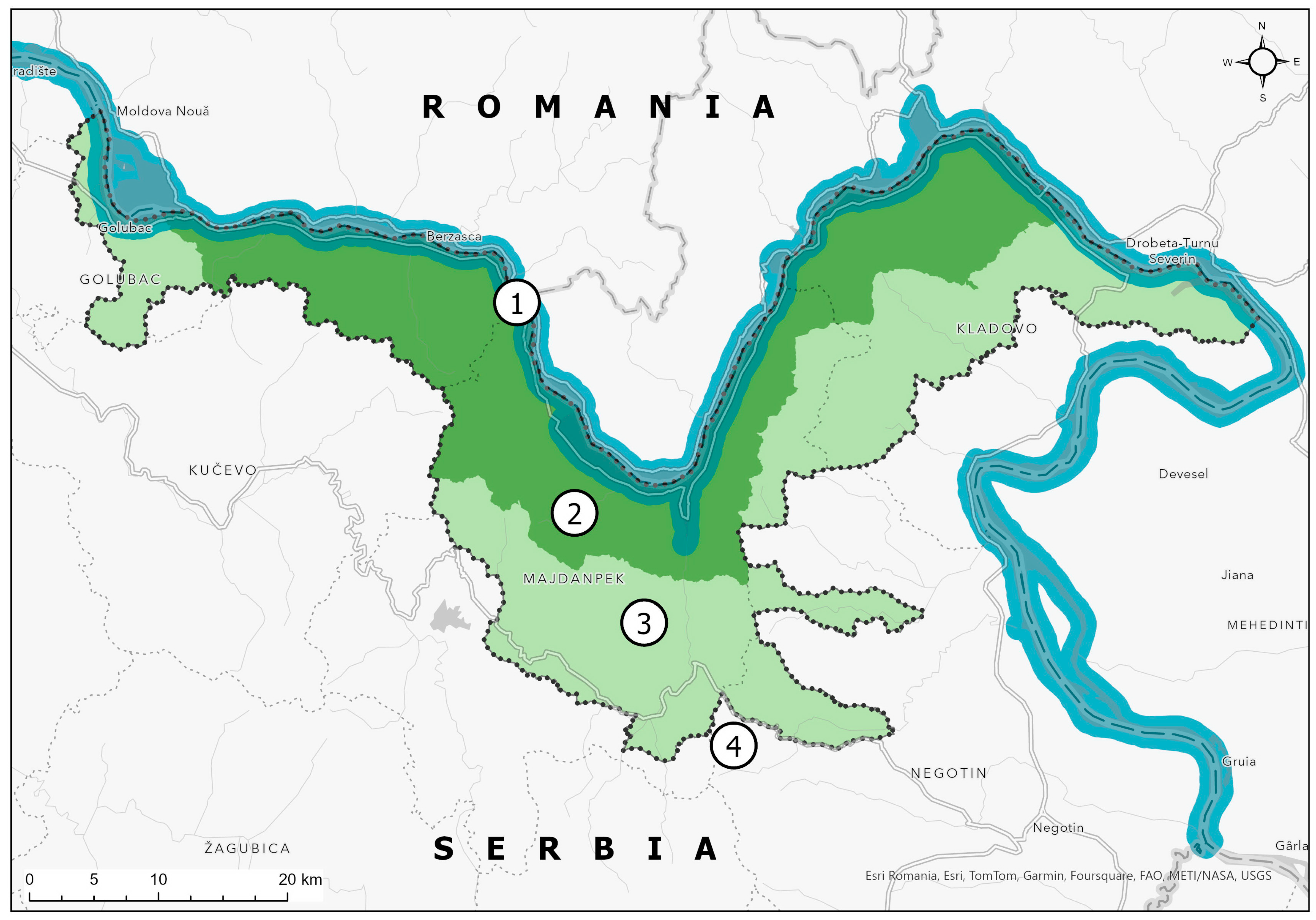
2.2. Case Study of SPSP Djerdap

The SPSP Djerdap 2022 is third in line with the spatial plans of a special purpose area developed for the area, after its declaration as a national park in 1974. This testifies to the continual attention to the area from the side of national institutions, striving for the protection of its territory. In comparison to previous plans (SPSP 1989 and SPSP 2013), the plan encompasses a considerably wider area that conditioned amendment and innovation of the data for all planning solutions. The methodology used for preparing the spatial plan is discussed, with particular emphasis on the treatment of cultural heritage. The overall objective of the paper is to explore how the spatial plan acts as an instrument for integrating international, national and local levels of cultural heritage protection, by using a multilevel, integrated and territorial approach.
Djerdap National Park was designated a protected area in 1974 by the Institute for Nature Protection of Serbia, primarily due to its exceptional natural attributes [29]. This status was further reinforced by its recognition as a UNESCO Global Geopark in 2020 [30], offering it both national and international institutional and legal protection. Both of these statuses required the adoption of relevant documents in the fields of governance by the competent organizations in order to achieve the protection, use and maintenance of the exceptional natural values in the area. Cultural heritage is highlighted as a value that must be treated in conjunction with natural heritage, without special guidelines. The case study area encompasses numerous immovable cultural property sites [31,32,33,34].
Djerdap National Park is located on the Danube River in northeastern Serbia, on the border with Romania. The area covered by the SPSP Djerdap, spanning approximately 172,700 hectares, encompasses the boundaries of three entities (Figure 1):
  • Djerdap National Park (covering around 64,000 hectares) was established in 1974. It includes the spatial unit of Djerdap Gorge and the natural area along the gorge, with exceptional cultural-historical values, significant natural ecosystems of exceptional rarity and value, original flora and fauna specimens, and well-preserved forests of natural composition and exceptional appearance.
  • Djerdap Geopark (covering approximately 133,000 hectares) was the first area from Serbia inscribed on the UNESCO World Geoparks List (Global Geoparks Network) in 2020. While not a protected area, the Geopark represents a specific concentration of geosites; a number of geological heritage sites are arranged, mostly within other protected areas, in the form of geological trails and individual structural profiles;
  • The Roman Empire border is the Danube Limes area, included in the preliminary list of the Republic of Serbia for inclusion in the international serial nomination, the Roman Empire border (from the Black Forest area (Schwarzwald) to the Black Sea).
Table 2 outlines different levels at which cultural heritage within the plan’s area is governed, as well as the main stakeholders involved. This aims to enhance comprehension of the multilevel approach with respect to its protection, because this principle ought to be integrated into the methodology for preparing the plan.

3. Findings: Contribution of the Applied Planning Methodology to Integrating Multilevel Principles and Actors into Plan Formation

The review of methodology for preparing plans for protected areas in international literature highlights the need for a multilevel approach to understanding the requirements for protecting cultural heritage as a whole and articulating the economic and societal need of the local community within a territory through planning standards [3,48,49]. The authors point to the need to integrate the normative and institutional frameworks for policy transfer between different levels of governance with a substantive understanding of the local initiatives, perspectives and constraints. These principles were tested in the framing of the planning methodology for the case of SPSP Djerdap. The primary goal in the case of SPSP Djerdap was to spatially and functionally apply an integrated and territorial approach to the protection, preservation and utilization of cultural heritage within the territory as one of the key resources for sustainable development.

3.1. Relevant Documents in Serbia for the Treatment of the Cultural Heritage at the Level of the Spatial Entites and Its Treatment in the Planning Documents

Among the five international charters in the field of the protection of cultural heritage (Table 3), Serbia ratified the EU cultural landscape charter [50], in the Official Gazette RS-International agreements, No. 4/11, and developed an action plan proposal for its implementation [51]. Djerdap National Park has been acknowledged as a cultural landscape [52]. However, it was not until 2021 that the Law on Cultural Heritage in Serbia introduced the category of cultural landscape [47], and its practical effects are yet to be observed. This situation reflects the current state of protection, characterized by a focus on individual localities lacking comprehensive protective mechanisms and a failure to recognize the value of buildings, units and entire settlements [21,22,23,53].

3.2. Legally Binding Elements in Planning: Content and Procedure

According to the planning law of RS [6], spatial plans define objectives and principles of strategic development of wider spatial entities, with general regulatory framework. They define entities of common spatial and developmental features (usually land use, transport and infrastructural systems of general importance), to be further elaborated through the more detailed plans of smaller scale.
The legislative states binding elements of plan content and plan procedure (Table 4), while the methodology of plan elaboration is not prescibed, i.e., depends on the planners. The next chapters describes the methodology applied in the SPSP Djerdap pointing to the elements which are not obligatory but can considerably contribute to the integration of conservation and planning through integration, territorial approach and digitalization.

3.3. The Case Study of the SPSP Djerdap: Introducing of the Non-Binding Planning Concepts, Elements and Tools within the Planning Methodology

In the case of the SPSP Djerdap, the planning area encompasses a broader area than the boundaries of the National Park (see Figure 1), whose management is entrusted to a special agency, and accordingly it is subject to the management rules prescribed by the agency’s statute and the Law on National Parks. Additionally, these two boundaries do not coincide with the boundary of the Djerdap Geopark, recognized as a unit comprising natural and cultural heritage and included on the UNESCO Global Geoparks list, which further entails a specific treatment of this unit. The serial nomination of the Roman Limes is on the UNESCO tentative list and protection measures prescribed by the Republic Institute for the Protection of Cultural Monuments apply to it. While the issue of overlapping jurisdiction areas can be debated, the biggest problem lies in areas that do not belong to the Geopark or the National Park, and are solely reliant on protection through spatial planning.
The methodology for formation of the spatial plan for the SPSP DJerdap included a comparative analysis of cultural heritage in the Djerdap Geopark, Djerdap National Park, and the rest of the planning area, based on available data from relevant institutions, as well as all other accessible sources (plans, internet, field research). The aim was to place all elements of cultural heritage, both registered and identified by competent authorities, on an equal footing, particularly those objects recognized as valuable through planning analysis, thus protecting them from inadequate interventions.
The existing legislature in the sectors of tourism, nature, and cultural heritage protection does not provide adequate instruments, or an integrative governance framework for the territories of the National Park and the Geopark. This is especially obvious at the locations where the sectoral jurisdictions are overlapping. For example, the medieval fortress Golubački grad and the archeological site Lepenski Vir represent at the same time cultural and natural heritage as well as being tourist sites. Consequently, the integrative governance of these areas is of crucial importance, and it requires tight intersectoral collaboration. However, the key management institutions and related documents are under the auspices of the Ministry of the Environment and are regulated solely by the Law on Nature Protection.
Starting from the point of the promoted principles of territorialization, integration and digitalization which stemmed from the elaboration of the strategic plan of higher level of spatial plan of RS, we tried to merge these principles with the regular planning content and procedure and as such to provide the framework for not only binding but also non-binding solutions (Table 5).
The territorial approach stems from the very nature of the planning document, which emphasizes that the spatial dimension of cultural heritage is insufficiently recognized, in a strictly conservationist sense. Cultural heritage is acknowledged as both a spatial resource and a resource for sustainable development. The result of the territorial approach is the integration of protected areas of the Djerdap National Park, the Djerdap Geopark and the areas without protection status. This opens up new possibilities for the spatial and functional revitalization of already protected immovable cultural properties. Additionally, immovable cultural properties under prior protection are further safeguarded, as they often lose their protected status if not declared within 3 years, despite their recognized value. Of particular importance is the evaluation of entities that are not under any institutional protection regime but represent significant spatial, historical, cultural and environmental elements through the application of the new methodological approach. Special measures are also envisaged for these entities.
The integrated approach is reflected in the following phases: (1) identification of cultural heritage, (2) formulation of objectives and planning solutions and (3) implementation of measures for the protection, preservation and use of cultural heritage. Through this approach, the aim is to overcome the limitations of a sectoral approach and to provide decision-makers, users and plan implementers with a broader perspective on protecting existing and perceiving potential immovable cultural properties. The result of the integrative approach is implementation measures that correspond to all areas of spatial development: transportation, infrastructure, tourism, the economy.
Identification involves analyzing the existing legal and planning framework and identifying points relevant to considering the spatial dimension of cultural heritage. Identification was carried out through the following: the collection, analysis and extraction of relevant content from planning documents, presented in a separate chapter of the spatial plan; the analysis of legal elements and articles supporting the treatment of cultural heritage as a spatial resource, with the particular consultation of ratified international charters in the field of cultural heritage protection, applied in proposals for plan implementation; the analysis of conditions obtained from relevant institutions responsible for various spatial development areas; the collection of data on immovable cultural assets from competent institutions and their classification for presentation in the plan and for providing planning guidelines; and the triangulation of data on immovable cultural assets obtained from relevant institutions with cultural assets identified in the Geopark and Danube Limes files. Collaboration was established with the Institute for Nature Conservation of Serbia, the Republic Institute for the Protection of Cultural Monuments and the Institute for the Protection of Cultural Monuments in Smederevo and Niš, which are the local level institutions that issue the conditions for the preparation of the spatial plan. The process of preparing the plan included cooperation with the Public Enterprise Djerdap National Park, the Tourist Organization of the Municipality of Majdanpek/Donji Milanovac, as well as with representatives of the municipal administrations of Golubac, Kučevo, Majdanpek, Kladovo and Negotin, whose role will be particularly pronounced in the process of implementing the planning solutions.
In the area of the spatial plan, there are a total of 186 sites of cultural and historical heritage (Figure S1: The visualisation of the recorded elements of cultural heritage of all types in the table (part), of which 41 are registered/established immovable cultural properties and 145 are recorded sites. Recorded sites include cultural and historical heritage a) under prior protection (according to the conditions obtained from competent institutions for the protection of cultural monuments) and b) with monumental properties established in another way (localities identified through the preparation of nomination files for Djerdap Geopark and the serial nomination Danube Limes, as well as localities that were registered by the competent institutions for the protection of cultural monuments, but lost their protection status because they were not declared within the legally established period). Some of the recorded localities are under prior protection and have protection status within Djerdap Geopark and/or the serial nomination Danube Limes.
Formulation of objectives and planning solutions has been included according to the promoted principles of integration, territorialization and digitalization. The main objectives are:
  • Protecting wider spatial entites containing cultural assets and in doing so overcoming solely administrative boundaries;
  • Making heritage visible and available to the wider community;
  • Defining cultural areas and cultural routes at the international, national and local levels along with the management plans for their sustainable use and development;
  • Further elaboration of nomination dossiers for WHC.
The planning solutions refer not only to the registered cultural assets but also to entire spatial entities that contain cultural and natural heritage and whose boundaries have been identified through the following: valorisation of the context relevant for the experience and presentation of cultural heritage through additional field work; initiating of the additional collaboration with the institutions in charge of heritage protection; involving local communities and citizens’ assosications.
Implementation of measures for the protection, preservation and use of cultural heritage involves planning-programmatic, normative-legal and institutional measures. Through these measures, efforts have been made to comprehensively address:
  • Preparation and regular adoption of management plans for protected areas, in the manner and with the content determined by law and declaration acts;
  • Tourism-development programs;
  • Connection between geological and other territorial heritage, i.e., natural biotic, cultural and intangible properties.
  • Building capacities to participate in future partnership strategies at national and international levels;
  • Education strategy in partnership with other global geoparks;
  • Activities to facilitate the mitigation of natural hazards and climate change in schools and local communities, etc.
Digitalization/presentation involves textual and graphical representation of the planning proposal. It is particularly significant for digitalization of the spatial values of cultural heritage. Entities are presented in the form of comprehensive tables, as well as in the form of reference maps, made in GIS (Figure S2: original reference map from the SPSP Djerdap: ‘Natural resources, tourism, environmental, natural and cultural heritage protection’). This process allowed synthesizing of the results of spatial value research and visualization of the collected and analyzed data, as well as their further use by interested actors.
Such an approach to visualizing the plan’s content facilitates an easier understanding of the space for the plan’s users: institutions, decision-makers, investors, citizens and interested stakeholders, as well as developers of detailed planning and urban-technical documents. It particularly enables more adequate delineation of the boundaries of future planning areas and avoids situations where the planning boundary follows administrative divisions and cuts across areas with homogeneous spatial-morphological characteristics. The SPSP Djerdap is developed in a GIS environment based on ESRI technology (ESRi ArcGIS Desktop v 10.8.1. ArcGIS Pro v 3.3.), allowing for easier data exchange, the formation of a Geographic Information System for the covered area and more efficient monitoring of the implementation of the plan. The land use reference maps show the following: the boundaries of the National Park, Geopark and spatial plan; the boundaries of local self-government units and cadastral municipalities; the transportation infrastructure and special designations; the regimes for protecting natural values and immovable cultural assets; tourist areas; mineral resources; and areas of special designation.

4. Discussion

Expanding the subject of protection and giving a spatial dimension to heritage entails the need for new forms of heritage management that can be defined through three phases: understanding the context, developing strategies and managing actions [5]. In the context of Serbia, there are preconditions for improving the treatment of cultural heritage in planning documents [21,22,23]. These are primarily ratified charters, a planning system that contains elements for the integrative treatment of cultural heritage as a spatial resource and a protection system that also introduces the cultural landscape category. However, at the same time, there are also obstacles in the form of the non-introduction of ratified charters into law, as well as the inefficiency of the implementation of the law, which is disproportionate to the scope of the normative matter, and the recently introduced landscape category is still without concrete application.
Concerning the general planning theory and the planning context of Serbia, the obstacles can be connected with the difficulties of transitioning from the earlier rational to the collaborative model of planning [54,55,56,57]. Although strategic by law definition, the ‘spatial plans for the special purpose areas’ usually possess the characteristics of a traditional land use model of planning: sectoral approach, rigidity and only formal citizen engagement. Drawing a parallel between strategic and traditional planning, the authors point to the essence of a spatial document which should be how the plan is developed, not what is defined by it [58]. However, in Serbia, the planning law defines the content of the plan and the adoption procedure, while the methodology is not defined. Given that Serbia belongs to the category of countries with binding legislation in the planning process, international charters and recommendations that have not been ratified and non-binding elements of law are not taken into account.
Advances in the planning methodology occur mostly through individual cases that over time become standard practice and consequently can influence the law and thus become binding. The SPSP Djerdap provides progress in terms of scope, tools, scale, actors and policy integration. The planning document applies a multi-level, integrative and territorial approach through:
  • Recognition of responsibilities at different decision-making levels and their inclusion in the plan’s implementation measures;
  • Recognition of cultural heritage that is not institutionally protected but represents an important spatial resource and must be treated integrally with other spatial resources with the obligation of synergistic action with compatible sectors (nature protection, tourism, urbanization) and avoiding conflicts (industry, mining, etc.);
  • Linking spatial scopes from different documents governing the said area, which give recommendations that are directed towards administrative units but which are not based on administrative divisions in a spatial sense.
This particularly applies to rural settlements in the Danube region. The fact is that even settlements located in the coastal zone, which are therefore more visited by both domestic and foreign tourists and have more potential for development, are already involved in numerous programs and projects. However, rural settlements are particularly exposed to processes of decay and depopulation. The SPSP Djerdap emphasizes the authenticity of these settlements and the need to preserve them in their authentic form, as well as to connect them into a network of cultural or tourist routes. By retaining existing values and introducing new connections, programs and content, it is possible to stimulate the sustainable development of these settlements [59,60]. The local community plays a special role in this; however, they must first be aware of the existing heritage and then actively participate in its enhancement.
The formation of the SPSP Djerdap facilitated a mandatory public inquiry that enabled broader public participation in the decision-making process. The draft spatial plan was presented to the general public via LGUs, the Ministry website and at the local administration premises for 30 days. Some of the citizen and stakeholder remarks pertained to the need to allow the interpolation of tourist facilities in the Danube riverbank zone, which would foster economic development in this area (SPSP Djerdap, plan documentation). This clearly indicates the existence of a conflict between strict intervention restrictions in the protected area and the real needs of the local population. The plan facilitated dialogue among different levels of stakeholders. However, the general impression is that many questions regarding local development in the field of cultural heritage protection were not raised during the public inquiry. The general assessment is that the awareness of the local population regarding cultural heritage is underdeveloped. In addition, Serbia as a post-socialist country exemplifies a rather low level of active citizen participation in planning processes, with urban and spatial planning traditionally perceived as a task of the public sector [61].
Another reason for insufficient public engagement in the process of preparing the plan is the lack of implementation of certain provisions of the Law on National Parks, according to which the public enterprises governing national parks need to have an advisory body composed of local self-government representatives [62]. This would further facilitate smoother communication and collaboration between different stakeholders at the local, national and international levels of decision making. Therefore, an integral understanding of the complexity regarding the development and protection within the case study’s territory exists only at the level of spatial planning, while its interpretation and implementation depend on the education, interests and decision-making power of the stakeholders.
Consideration should be given to enhancing the capacity of the local community in degraded areas in the Danube region in Serbia to sustainably utilize local heritage for creating new opportunities and improving the quality of life. Some EU-funded projects have an important role in this regard, by supporting households to promote and protect heritage through targeted economic activities in the field of tourism, or by providing tangible investments in infrastructure and/or the revitalization of protected areas. The scaling-up of local solutions and enhancing their digital and physical visibility at national and supranational levels (i.e., via cultural routes—Interreg project ISTER [63]) may contribute to attracting new investments for integrated projects and more effective implementation of spatial plans supporting these initiatives.
This highlights the need to develop capacities for participatory planning at the local level to meet the demands for democratization, societal justice and multilevel governance, especially in the protected areas that have complex requirements [64]. Social groups should be enabled to manage their collective efforts in balancing protection and economic development, and share responsibility for decisions made. In the case of Djerdap National Park, this requires small steps and the use of soft engagement methods as a catalyst for transformation. These steps include the following: (1) recognition of current relationships between the actors at local, national and supranational levels and the creation of new relationships (i.e., establishing cooperation with local communities in areas with similar conditions regarding local cultural identity to seek new solutions through collaboration); (2) acknowledging emerging concerns and priorities through a multilevel approach to enable common understanding of problems; and (3) shifting existing perceptions and values, along with the goals of the planning process to achieve better integration of propositions within plans [65,66].

5. Conclusions

Although spatial plans can significantly contribute to an integrated understanding of the territory regarding its overall natural and anthropogenic potentials, this is not always the case, because the methodology for drafting plans is not legally binding. In other words, in planning practice, only procedures prescribed by law are usually applied. Moreover, elements of international documents concerning integrative and territorial planning approaches have not yet been incorporated into the law, despite the ratification of a certain number of charters, and the fact that the scientific and professional community is familiar with current trends. However, depending on the stance of planning professionals, it is possible to improve planning methodology by introducing elements and analyses that are not legally binding, but ensure more efficient implementation of integrative and territorial approaches in planning practice.
The cultural heritage within the boundaries of the SPSP Djerdap, with the exception of the Roman Limes, is still recognized at the level of individual sites. It is necessary for the development of the planning document to integrate different levels and principles for governing cultural heritage towards protecting the area as a whole rather than just individual sites. The international and national significance of the area contributes to raising awareness of heritage and its institutional protection, primarily determined by identified natural potentials. However, the vitality of the area, crucial for its sustainable development, comes from the local level and the synthesis of natural and anthropogenic potentials, including cultural heritage. Planning documents precisely contribute to integrating local values and communities into development programs and projects. Through identification, defining planning solutions and goals, presentation and implementation measures, planning documents can serve as a direct starting point for interventions or as a stimulus for a more detailed analysis of specific areas. In the field of implementation, it is necessary to ensure the institutional cooperation of all actors involved in spatial protection, since this is crucial for achieving positive effects in the space and society.

6. Patents

‘The innovative metodological approach to the integrated planning and management in the field of the protection of cultural heritage of national and international importance and sustainable development in Serbia (the example of the spatial plan of the special purpose area)’ has been accepted from the Ministry of Science, Technological development and innovation of the Republic of Serbia, as the ‘new technical solution (method) applied at the national level’.

Supplementary Materials

The following supporting information can be downloaded at: https://www.mdpi.com/article/10.3390/land13071026/s1, Figure S1: The visualisation of the recorded elements of cultural heritage of all types in the table (part); Figure S2: Reference map from the SPSP Djerdap (2022): “Natural resources, tourism, environmental, natural and cultural heritage protection”. Table S1: Items of cultural heritage within the Djerdap Geopark; Table S2: Cultural heritage sites within the Roman Limes serial nomination.

Author Contributions

Conceptualization, A.N. and B.M.; methodology, A.N., B.M., N.K. and N.Č.M.; validation, A.N., B.M., N.Č.M. and N.K.; investigation A.N. and N.Č.M.; writing—original draft preparation, A.N. and N.Č.M.; writing—review and editing, B.M. and N.K.; visualization, N.K. All authors have read and agreed to the published version of the manuscript.

Funding

The research presented in this paper is supported by the Ministry of Science, Technological Development and Innovation of the Republic of Serbia (No. 451-03-68/2023-14/200006).

Data Availability Statement

Data are contained within the article and Supplementary Materials.

Conflicts of Interest

The authors declare no conflicts of interest.

References

  1. UNESCO. Recommendation on the Historic Urban Landscape; UNESCO: Vienna, Austria, 2011. [Google Scholar]
  2. Council of Europe. Territorial Agenda of the European Union 2020: Towards an Inclusive, Smart and Sustainable Europe of Diverse Regions; Council of Europe: Gödöllő, Hungary, 2011. [Google Scholar]
  3. Guzmán, P.C.; Pereira Roders, A.R.; Colenbrander, B.J.F. Measuring links between cultural heritage management and sustainable urban development: An overview of global monitoring tools. Cities 2017, 60 Pt A, 192–201. [Google Scholar] [CrossRef]
  4. Stegmeijer, E.; Veldpaus, L.; Janssen, J. Introduction to a research agenda for heritage planning: The state of heritage planning in Europe. In A Research Agenda for Heritage Planning, Perspectives from Europe; Veldpaus, L., Stegmaijer, E., Eds.; Edward Elgar Publishing: Cheltenham, UK; Northampton, MA, USA, 2021; pp. 3–21. [Google Scholar]
  5. Veldpaus, L. Historic Urban Landscapes: Framing the Integration of Urban and Heritage Planning in Multilevel Governance. Ph.D. Thesis, Technische Universiteit Eindhoven, Eindhoven, The Netherlands, 2015. [Google Scholar]
  6. NARS—National Assembly of the Republic of Serbia. Law on the Planning System of Serbia. In Official Gazette RS, No. 30/2018; National Assembly of the Republic of Serbia: Belgrade, Serbia, 2018. [Google Scholar]
  7. NARS—National Assembly of the Republic of Serbia. Strategy of the sustainable urban development of the Republic of Serbia. In Official Gazette RS, No. 47/2019; National Assembly of the Republic of Serbia: Belgrade, Serbia, 2019. [Google Scholar]
  8. Group of Institutions. PPRS 2021–2035: Spatial Plan of the Republic of Serbia, 2021–2035. (In Process of Adoption); National Assembly of the Republic of Serbia: Belgrade, Serbia, 2021.
  9. Čolić, N.; Nedović-Budić, Z. Public interest as a basis for planning standards in urban development: State-socialist and post-socialist cases in Serbia. J. Plan. Educ. Res. 2021. [Google Scholar] [CrossRef]
  10. Rhodes, R.A.W. Understanding Governance: Ten Years On. Organ. Stud. 2007, 28, 1243–1264. [Google Scholar] [CrossRef]
  11. Borraz, O.; Galès, P.L. Urban governance in Europe: The government of what? Pôle Sud 2010, 1, 137–151. [Google Scholar] [CrossRef]
  12. Hyden, G. Making the State Responsive: Rethinking Governance Theory and Practice. In Making the State Responsive: Experience with Democratic Governance Assessments; Hyden, G., Samuel, J., Eds.; UNDP: New York, NY, USA, 2011; pp. 5–28. [Google Scholar]
  13. Jessop, B. Territory, Politics, Governance, and Multispatial Metagovernance. Territ. Politics Gov. 2016, 4, 8–32. [Google Scholar] [CrossRef]
  14. Čolić, R.; Milić, Đ.; Petrić, J.; Čolić, N. Institutional capacity development within the national urban policy formation process—Participants’ views. Environ. Plan. C Politics Space 2022, 40, 69–89. [Google Scholar] [CrossRef]
  15. European Commision. Urban Agenda for the EU ‘Pact of Amsterdam’; European Commision: Amsterdam, The Netherlands, 2016. [Google Scholar]
  16. Tasan-Kok, T.; Vranken, J. Handbook for Multilevel Urban Governance in Europe: Analysing Participatory Instruments for an Integrated Urban Development; EUKN: The Hague, The Netherlands, 2011. [Google Scholar]
  17. Mäkinen, K. Scales of participation and multi-scalar citizenship in EU participatory governance. Environ. Plan. C Politics Space 2021, 39, 1011–1029. [Google Scholar] [CrossRef]
  18. Fioretti, C.; Pertoldi, M.; Busti, M.; Van Heerden, S. Handbook of Sustainable Urban Development Strategies; Publications Office of the European Union: Luxembourg, 2020. [Google Scholar]
  19. Healey, P. Transforming Governance: Challenges of Institutional Adaptation and a New Politics of Space. Eur. Plan. Stud. 2006, 14, 299–334. [Google Scholar] [CrossRef]
  20. Rzasa, K.; Ogryzek, M.; Kulawiak, M. Cultural Heritage in Spatial Planning. In 2016 Baltic Geodetic Congress (BGC Geomatics); IEEE: Gdansk, Poland, 2016; pp. 85–89. [Google Scholar]
  21. Niković, A.; Manić, B. The challenges of planning in the field of cultural heritage in Serbia. Facta Univ. Ser. Archit. Civ. Eng. 2018, XVI, 449–463. [Google Scholar] [CrossRef]
  22. Niković, A.; Manić, B. Building a Common Platform: Integrative and Territorial Approach to Planning Cultural Heritage within the Framework of the Spatial Plan of the Republic of Serbia 2021–2035. In REAL CORP 2020: Shaping Urban Change. Livable City Regions for the 21st Century-Aachen, Germany; Schrenk, M., Popovich, V.V., Zeile, P., Elisei, P., Beyer, C., Ryser, J., Reicher, C., Çelik, C., Eds.; CORP—Competence Center of Urban and Regional Planning: Vienna, Austria, 2020; pp. 107–115. [Google Scholar]
  23. Niković, A.; Manić, B. Prostorna dimenzija zaštite kulturnog nasleđa u Srbiji: Prilog unapređenju institucionalnog i pravnog okvira. In Zbornik Radova: XI Naučnostručna Konferencija “Graditeljsko Nasleđe i Urbanizam”; Mrlješ, R., Ed.; Zavod za Zaštitu Spomenika Kulture Grada Beograda: Beograd, Srbija, 2021; pp. 346–359. [Google Scholar]
  24. Nadin, V.; Stead, D.; Dąbrowski, M.; Fernandez Maldonado, A.M. Integrated, adaptive and participatory spatial planning: Trends across Europe. Reg. Stud. 2021, 55, 791–803. [Google Scholar] [CrossRef]
  25. Dabrowski, M.M. Multi-Level and Multi-Actor Governance: Why it matters for spatial planning. In Teaching, Learning & Researching Spatial Planning; Rocco, R., Bracken, G., Newton, C., Dabrowski, M., Eds.; TU Delft OPEN Publishing: Delft, The Netherlands, 2022; pp. 56–67. [Google Scholar]
  26. NARS—National Assembly of the Republic of Serbia. Law on Planning and Construction. In Official Gazette RS, No. 72/09; National Assembly of the Republic of Serbia: Belgrade, Serbia, 2009. [Google Scholar]
  27. Stefanović, N.; Danilović Hristić, N.; Srnić, D. A methodological framework for integrated planning in the protection and development of natural resource areas in Serbia—A case study of spatial plans for special purpose areas for protected natural areas. Spatium 2018, 40, 25–32. [Google Scholar] [CrossRef]
  28. NARS—National Assembly of the Republic of Serbia. Spatial Plan for the Special Purpose Area of the Djerdap National. In Official Gazette RS, No. 117/2022; National Assembly of the Republic of Serbia: Belgrade, Serbia, 2022. [Google Scholar]
  29. ZZPS-Zavod za Zaštitu Prirode Srbije. Nacionalni Park “Đerdap”. 2023. Available online: https://zzps.rs/nacionalni-park-djerdap/ (accessed on 2 March 2021).
  30. UNESCO. Djerdap UNESCO Global Geopark. 2021. Available online: https://en.unesco.org/global-geoparks/djerdap (accessed on 2 March 2021).
  31. Basarić, J. Kulturno nasleđe kao turistički potencijal Donjeg Podunavlja u Srbiji. Arhit. Urban. 2023, 56, 46–57. [Google Scholar]
  32. Nikolić, M.; Šćekić, J. Kulturno i prirodno nasleđe Đerdapa—Izgubljena istorija ili potencijal za održivi razvoj. Arhit. Urban. 2022, 55, 24–37. [Google Scholar]
  33. Dobričić, M.; Sekulić, G.; Josimović, B. Procena kulturno-istorijskih i drugih ekosistemskih vrednosti Nacionalnog parka Đerdap. Arhit. Urban. 2022, 54, 5–14. [Google Scholar]
  34. Maran Stevanović, A. Activities on the establishment of Djerdap geopark (Serbia) and candidature of the area to the UNESCO Global Geopark Network. Bull. Nat. Hist. Mus. 2017, 10, 7–28. [Google Scholar] [CrossRef]
  35. Geopark Djerdap. 2020. Available online: https://geoparkdjerdap.rs/?pismo=lat (accessed on 2 March 2021).
  36. Rabrenović, D.; Manojlović, S.; Radaković, N.; Milovanović, Z.; Drndarević, D.; Milojković, D.; Maran Stevanović, A.; Ćalić, J.; Marinčić, S.; Srećković-Batoćanin, D.; et al. Application Dossier for Membership in Unesco Global Geoparks Network; NP Djerdap: Donji Milanovac, Serbia, 2017. [Google Scholar]
  37. Viminacium. Danube Limes Brand/Dunavski Limes Kao Brend. 2024. Available online: http://viminacium.org.rs/en/projekti/danube-limes-brand/ (accessed on 20 March 2021).
  38. RZZZSK—Republički Zavod za Zaštitu Spomenika Kulture. Rimski Limes u Srbiji na Preliminarnoj Listi Svetske Baštine. 2024. Available online: https://www.heritage.gov.rs/latinica (accessed on 2 March 2021).
  39. UNESCO WHC (1992–2024). Frontiers of the Roman Empire—The Danube Limes (Serbia). 2024. Available online: https://whc.unesco.org/en/tentativelists/6475/ (accessed on 20 March 2021).
  40. UNESCO WHC (1992–2024). The World Heritage Convention. 2024. Available online: https://whc.unesco.org/en/convention/ (accessed on 20 March 2021).
  41. UNESCO (1992–2024). Upper German Raetian Limes Management Plan 2019–2023. 2024. Available online: https://whc.unesco.org/en/list/430/documents/ (accessed on 20 March 2021).
  42. UNESCO (1992–2024). The Operational Guidelines for the Implementation of the World Heritage Convention. 2024. Available online: https://whc.unesco.org/en/guidelines/ (accessed on 20 March 2021).
  43. Nacionalni Park Djerdap. 2020. Available online: https://npdjerdap.rs/?pismo=lat (accessed on 2 March 2021).
  44. NARS—National Assembly of the Republic of Serbia. Law on the National Parks. In Official Gazette RS, No. 84/2015; National Assembly of the Republic of Serbia: Belgrade, Serbia, 2015. [Google Scholar]
  45. RZZZSK-Republički Zavod za Zaštitu Spomenika Kulture. Centralni Registar NKD [Central Catalogue of IMP-Immovable Cultural Property]. 2024. Available online: https://heritage.gov.rs/english/nepokretna_kulturna_dobra.php (accessed on 12 December 2023).
  46. NARS—National Assembly of the Republic of Serbia. Spatial Plan for the Special Purpose Area of the Djerdap National. In Official Gazette RS, No. 43/2013; National Assembly of the Republic of Serbia: Belgrade, Serbia, 2013. [Google Scholar]
  47. NARS—National Assembly of the Republic of Serbia. Cultural Heritage Law. In Official Gazette RS, No. 129/21; National Assembly of the Republic of Serbia: Belgrade, Serbia, 2021. [Google Scholar]
  48. Siguencia, M. Planning and heritage integration in multilevel governance: Cuenca, Ecuador. In The Future of the Past: Paths towards Participatory Governance for Cultural Heritage, 1st ed.; Garcia, G., Vandesande, A., Cardoso, F., Van Balen, K., Eds.; CRC Press: London, UK, 2021; pp. 101–108. [Google Scholar]
  49. Tarrafa Silva, A.; Pereira Roders, A.; Cunha Ferreira, T.; Nevzgodin, I. Critical Analysis of Policy Integration Degrees between Heritage Conservation and Spatial Planning in Amsterdam and Ballarat. Land 2023, 12, 1040. [Google Scholar] [CrossRef]
  50. Council of Europe. The European Landscape Convention; Council of Europe: Florence, KY, USA, 2000. [Google Scholar]
  51. RS-Republika Srbija Ministarstvo Poljoprivrede i Zaštite životne Sredine; Ministarstvo Kulturne i Informisanja; SIPU International AB; PROFID. Predlog Akcionog Plana za Implementaciju Evropske Konvencije o Predelu u Srbiji; National Assembly of the Republic of Serbia: Belgrade, Serbia, 2014.
  52. Crnčević, T.; Milijić, S.; Bakić, O. Prilog razvoju metodološkog pristupa planiranja predela u Republici Srbiji na primeru nacionalnog parka Djerdap. Arhit. Urban. 2012, 35, 22–33. [Google Scholar]
  53. Maksin Mićić, M. Some problems of integrating the landscape planning into the spatial and environmental planning in Serbia. Spatium 2003, 9, 28–33. [Google Scholar] [CrossRef]
  54. Maksin, M. Planning system for sustainable territorial development in Serbia. Int. J. Environ. Sustain. Dev. 2014, 13, 296–314. [Google Scholar] [CrossRef]
  55. Lazarević Bajec, N. Rational or collaborative model of urban planning in Serbia: Institutional limitations. Serbian Archit. J. 2009, 1, 81–106. [Google Scholar] [CrossRef]
  56. Vujošević, M. Collapse of strategic thinking, research and governance in Serbia and possible role of the Spatial Plan of the Republic of Serbia in its renewal. Spatium 2010, 23, 22–29. [Google Scholar] [CrossRef]
  57. Perić, A. The evolution of planning thought in Serbia: Can planning be ‘resilient’ to the transitional challenges? In History-Urbanism-Resilience—Proceedings of the 17th International Planning History Society Conference; Hein, C., Ed.; TU Delft Open: Delft, The Netherlands, 2016; Volume 7, pp. 181–193. [Google Scholar]
  58. Albrechts, L. Strategic (spatial) planning reexamined. Environ. Plan. B Plan. Des. 2004, 31, 743–758. [Google Scholar] [CrossRef]
  59. Marić, I.; Niković, A.; Manić, B. Kulturno nasleđe, prirodne vrednosti i novi programi u funkciji razvoja turizma ruralnih područja. In Održivi Razvoj Banjskih i Turističkih Naselja u Srbiji; Pucar, M., Josimović, B., Eds.; IAUS: Beograd, Srbija, 2010; pp. 159–184. [Google Scholar]
  60. Manić, B.; Krunić, N.; Niković, A. Izazovi neposrednog sprovođenja strateških planskih dokumenata—Planovi jedinica lokalne samouprave sa uređajnim osnovama. In Letnja Škola Urbanizma (19; 2023; Vrnjačka Banja); Jevtić, A., Drašković, B., Eds.; Udruženje Urbanista Srbije: Beograd, Srbija, 2023; pp. 3–12. [Google Scholar]
  61. Čolić, N.; Dželebdžić, O. Beyond formality: A contribution towards revising the participatory planning practice in Serbia. Spatium 2018, 39, 17–25. [Google Scholar] [CrossRef]
  62. VOICE-Vojvođanski Istraživačko-Analitički Centar. Nacionalni Parkovi i Dalje bez Stručnog Saveta i Saveta Korisnika [National Parks Still without Expert Advisory Body and User Advisory Body]. 2018. Available online: https://voice.org.rs/nacionalni-parkovi-i-dalje-bez-strucnog-saveta-i-saveta-korisnika/ (accessed on 15 December 2022).
  63. Marcu, F.; Cupcea, G.; Dogărel, Ş. ISTER—ConnectIng hiSTorical Danube rEgions Roman Routes. INTERREG Danube Transnational Program. 2022. Available online: https://www.interreg-danube.eu/approved-projects/ister (accessed on 27 March 2024).
  64. Healey, P. Collaborative planning in perspective. Plan. Theory 2003, 2, 101–123. [Google Scholar] [CrossRef]
  65. Forester, J. On the evolution of a critical pragmatism. In Encounters in Planning Thought, 1st ed.; Haselsberger, B., Ed.; Routledge: New York, NY, USA, 2017; pp. 298–314. [Google Scholar]
  66. Čolić, N.; Dželebdžić, O.; Čolić, R. Building on Recent Experiences and Participatory Planning in Serbia: Toward a New Normal. In The ‘New Normal’ in Planning, Governance and Participation: Transforming Urban Governance in a Post-Pandemic World; Lissandrello, E., Sørensen, J., Olesen, K., Nedergård Steffansen, R., Eds.; Springer International Publishing: Cham, Switzerland, 2023; pp. 41–56. [Google Scholar]
Figure 1. The areas of the SPSP Djerdap: 1. Roman Limes; 2. National Park, 3. Geopark, 4. Outside of the protected areas.
Land 13 01026 g001
Table 1. The key principles and their relations to theory and practice.
The Key Principles of Improved Planning Methodology Connected Theoretical ConceptsConnected Practical Concepts and Tools
Territorial approachMultilevel governance:
  • Vertical integration of international, national and local levels of governance
  • Horizontal integration of sectors and disciplines
  • Cross-cutting (multiactor) dimension
Specific and context sensitive policy integration
Citizen engagement
Integrated approachHolistic strategies and coordinated actions of all participants
DigitalizationShared databases; mapping
Visualisation
Table 2. The interrelating different spatial levels of heritage protection in the national park Djerdap.
StatusDocuments/LinksManagement InstitutionsGoals/Expected Effects
International levelUNESCO Global Geopark (2020) [35,36]
  • UNESCO
  • PE Djerdap National Park
Holistic concept of protection, education and sustainable development.
World Heritage Centre, tentative list (2020)
[37,38,39,40,41,42]
  • Frontiers of the Roman Empire—the Danube Limes in Serbia;
  • Institute for the Protection of Cultural Monuments of Serbia (RZZZSK) See: Table S2
  • UNESCO
  • Institute for the Protection of Cultural Monuments of the RS, Archeological Institute, National Museum
The process of increasing the public awareness; protection and care, research and presentation; development possibilities; planning guidelines.
National levelNational Park (1974) [43,44]
  • Law on National Parks (2015)
  • Environment Protection Institute of Serbia (ZZZPS)
  • PE Djerdap National Park
Preservation, protection, and enhancement of cultural-historical heritage and geological heritage objects of Djerdap National Park.
Immovable cultural properties—registered and categorized
[45,46,47]
  • Central Registry of Immovable Cultural Heritage (RZZZSK, 2024)
  • Law on Cultural Heritage (2021)
  • Institute for the Protection of Cultural Monuments of Serbia (RZZZSK)
Protection and preserving of CH through: covering, collecting, researching, documenting, studying, evaluating, presenting, interpreting, using and managing cultural heritage.
Local levelImmovable cultural properties—identified, recorded and other (identified through field work and alternative sources)
  • Evidence lists for recording cultural properties under prior protection
  • SPSP Djerdap 2022 [28] and 2013 [46]
  • Local spatial and urban plans
  • Scientific and professional papers on the importance of local cultural heritage
  • Territorial institutes for the protection of cultural monuments (Niš and Smederevo);
  • Ministry of construction, transport and infrastructure of the RS;
  • Local government units;
  • Universities, Institutes etc.
Protection of all valuable elements of the physical environment regardless of their institutional protection status; valorization of the context through additional research in the field; communication and collaboration between stakeholders, especially planners, conservationists and communities.
Table 3. The international charters ratified in RS.
The Document TitleAdopted by UNESCO/COERatified by RS
Convention Concerning the Protection of the World Cultural and Natural Heritage19721974
Convention for the Protection of the Architectural Heritage of Europe-Granada19851991
European Convention on the Protection of the Archaeological Heritage19922007
Convention on the Value of Cultural Heritage for Society20052010
European Landscape Convention20002011
Table 4. Legally binding elements in planning.
Legally Binding
Content(1) Determing the boundaries according to the principle of administrative territorial division; (2) Textual part (SWOT analysis; Goals and principles of spatial development; Development concepts by sectors/disciplines); (3) Graphic part/maps (Special purpose of space; Settlements’ network and infrastrucutre system; Natural resources, protection of life environment, nature and cultural assets; Implementation)
Procedure(1) The Decision on the plan elaboration; (2) Early public consultations; (3) Acquiring conditions and data; (4) Preparing the draft plan; (5) Professional control: check of the compatibilty with law, the documents in force, feasibility; (6) Public consultations of the draft plan; (7) The commision conclusion; (8) Delivering the plan; (9) Publishing and archiving the plan.
Table 5. Non-binding elements of plans introduced in the SPSP Djerdap 2022.
Territorial approachHorizontal integration of the areas of SPSP 2013, Geopark and National Park Djerdap; Merging admistrative boundaries in recognizing spatial entities that contains cultural and natural heritage.
Integrated approachIdentification of all registered and non-registered cultural heritage elements; Vertical integration of all levels of governance from supranational, national and local levels; Horizontal integration of all sectors and disciplines involved and conflict mitigation; Multiactor involvment of local communities and associations in the decision making process.
DigitalizationProducing the tables of integrated elements of cultural heritage and shared database in GIS; Maps of spatial distribution of cultural heritage ovelapped with other sectors of spatial protection (nature, tourism and other resources of sustainalable development).
Disclaimer/Publisher’s Note: The statements, opinions and data contained in all publications are solely those of the individual author(s) and contributor(s) and not of MDPI and/or the editor(s). MDPI and/or the editor(s) disclaim responsibility for any injury to people or property resulting from any ideas, methods, instructions or products referred to in the content.

