Article

Patterns of Urban Sprawl and Agricultural Land Loss in Sub-Saharan Africa: The Cases of the Ugandan Cities of Kampala and Mbarara

by
Ronald O. Muchelo
1,2,*,
Thomas F. A. Bishop
1,
Sabastine U. Ugbaje
3 and
Stephen I. C. Akpa
4
1
Department of Environmental Sciences, School of Life Sciences, The University of Sydney, Biomedical C81, 1 Central Avenue, Australian Technology Park, Sydney, NSW 2006, Australia
2
Faculty of Higher Education, Holmes Institute, 91 York Street, Sydney, NSW 2000, Australia
3
Agriculture and Food, Commonwealth Research and Industrial Organization, Black Mountain, Canberra, ACT 2601, Australia
4
Agriculture Victoria Research, 110 Natimuk Rd, Horsham, VIC 3400, Australia
*
Author to whom correspondence should be addressed.
Land 2024, 13(7), 1056; https://doi.org/10.3390/land13071056
Submission received: 4 May 2024 / Revised: 18 June 2024 / Accepted: 20 June 2024 / Published: 15 July 2024

Abstract

:
Sub-Saharan Africa (SSA) is undergoing rapid urbanization, yet research comparing urban expansion and agricultural land loss in peri-urban areas is scarce. This study utilizes multi-temporal Landsat imagery to examine the impact of urban growth on agricultural land and fragile ecosystems in Kampala (a mega city) and Mbarara (a regional urban center) in Uganda. We distinguish between random and systematic land-use and land-cover (LULC) transitions in the landscape. The results reveal substantial urban expansion. Kampala’s urban area surged from 7.14% in 1989 to 55.10% in 2015, while Mbarara increased from 6.37% in 2002 to 30.95% in 2016. Correspondingly, agricultural land decreased, from 48.02% to 16.69% in Kampala, and from 39.92% to 32.08% in Mbarara. Notably, a significant proportion of urban growth in both cities encroached upon agricultural land (66.7% in Kampala and 57.8% in Mbarara). The transition from agricultural to built-up areas accounted for 14.72% to 28.45% of the landscapes. Additionally, unsustainable practices led to the conversion of wetlands and forests to agricultural land, with approximately 13% of wetlands and 23% of Savannah and forests being converted between 2001 and 2015. These findings underscore the necessity of monitoring LULC changes for sustainable urban growth management, emphasizing the importance of preserving agricultural land and ecosystems to ensure present and future food security. This research contributes to the understanding of urbanization’s impact on peri-urban agricultural land and ecosystems in SSA, providing insights that are crucial for informed urban planning and policy formulation aimed at sustainable development in the region.

1. Introduction

Urbanization, characterized by the proliferation of urban centers and the expansion of existing cities, is a defining phenomenon of the contemporary era, driven primarily by population growth, economic development, and rural-to-urban migration dynamics. As more than half of the global population currently resides in urban areas, and with urban populations continuing to burgeon, particularly in low-income countries, the transformative impacts of urbanization on land use and land cover (LULC) are increasingly pronounced [1]. This has led to an increase in the number of urban centers and the expansion of the existing cities, a phenomenon commonly referred to as urbanization. Urbanisation, which involves the irreversible replacement of natural land cover with settlements, roads, parking lots, pavements, and buildings, is one of the major triggers of land-use and land-cover (LULC) transformations [2,3]. The greatest challenge of urbanization in many developing countries is that the rate of urban growth is high and unregulated, especially in Sub-Saharan Africa (SSA) [4,5].
Recent reports indicate that 12 of the 30 fastest-growing cities globally are in SSA, highlighting the urgency of addressing urban expansion’s environmental impacts (World Population Review Report, 2024; City Mayors Report, 2020). Many studies of LULC across cities in SSA have shown an annual growth rate of built-up area reaching up to 8% [6,7,8,9,10,11,12,13,14,15,16,17] which is far higher than the global average of 3.66% [18]. Compared to many regions of the world, SSA is by far affected by the adverse impacts of LULC change, particularly the expansion of urban areas into fragile ecosystems, such as agricultural lands, wetlands, and forests. This expansion, often unregulated, exacerbates environmental degradation, threatens biodiversity, and reduces arable land [13,19,20,21,22]. For instance, LULC analyses for Kumasi (Ghana) in West Africa revealed urban expansion led to about a 20.8% decline in agricultural land between 1986 and 2016 [13]. Similar results have been reported for town and cities in Nigeria [23,24], Kenya [11], Tanzania [25], Ethiopia [19,26]. This decline is attributed to the inability of the farmers to replace lost land as only 11% are able to replace lost land [27]. Projections reveal that by 2030, about 80% of the current small-scale farmers engaged in urban and peri-urban agriculture will lose their agricultural land to urban housing development [28,29,30,31].
Whilst there are several studies that have quantify LULC changes around major cities in SSA using multi-temporal image classification and the conventional interpretation of the confusion matrix [13,32,33,34], far fewer studies have assessed LULC change in a wholistic manner that incoporates a robust metrics of landscape transitions [35]. For example, a naïve interpretation of the confusion matrix using the total quantity of a land category between two points in time might indicate a zero net change, while in actual fact the changes may be masked by the equal amounts of the losts and gains of the land category occuring at different locations. This type of land transition is termed a swap. Swapping is an important driver of LULC change in peri-urban agriculture (PAU) in SSA [34,36], but the extent of agricultural land gains through swapping processes is still unknown. This has led to possible underestimation of the original agricultural lands lost to urbanization. Therefore, it is of paramount importance to understand the extent of agricultural land gained through swapping, especially involving fragile lands that are necessary for environmental protection [23]. This is particularly vital in the case of SSA, where traditionally, farmers in SSA cities tend to encroach on forests and other fragile ecosystems to compensate for agricultural land lost to urbanization [37].
Another key benefit of employing the robust metrics of landscape transitions is the ability to separate random from systematic landscape transitions. From the statistical viewpoint of LULC change, a random transition implies that a land category is losing to or gaining from others in proportion to the availability or size of the other categories [38]. Thus, any major devitaion of losses or gains from this proprtion is termed a systematic transition [38,39,40]. This distinction between random and systematic LULC change allows reserachers and policy makers to target the dominant signals of change in the landscape, unravel their drivers and design the optimal solution to ameliorate their negative impacts.
In this study, we quantify and elucidate the extent of agricultural land loss, identify dominant patterns of LULC change, and assess landscape transitions involving agricultural land and fragile ecosystems in Kampala and Mbarara, two urban centers situated in Uganda. Specifically, we seek to provide empirical evidence linking urban growth, agricultural land loss, and encroachment upon sensitive ecosystems, such as wetlands and forest cover, adjacent to urban centers. Kampala and Mbarara are typical of many many towns and cities of SSA where rapid urbanization and agricultural land loss are posing significant environmental challenges. However, we hypothesisze the landscape trasition and patterns between Kampala and Mbarara are different, given the the contrast in size, population density and function. The specific objectives of this study are:
  • analyze and compare the rates of urbanization in a large urban center like Kampala against that of a smaller urban center such as Mbarara;
  • assess the extent of agricultural land conversion to urban use in large and small urban centers, quantifying both the gains and losses to promote policies that balance urban growth with the need to preserve agricultural productivity;
  • examine how urban expansion affects fragile ecosystems, including wetlands, forests, and other ecologically sensitive areas to understand the environmental consequences of urban sprawl on fragile ecosystems.

2. Materials and Methods

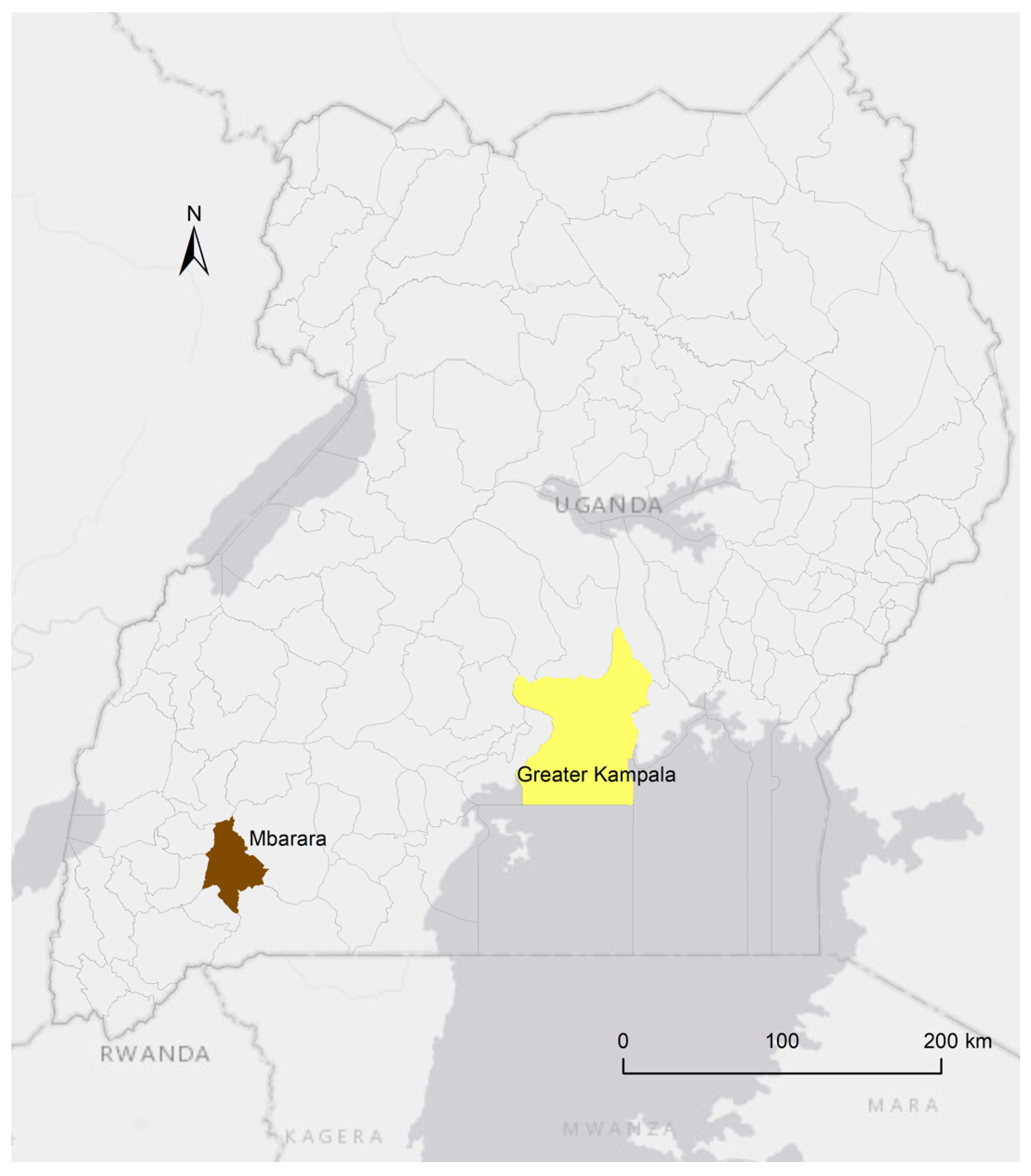
2.1. The Background of Study Sites

The study focused on two urban centers: Kampala and Mbarara (Figure 1). Kampala serves as Uganda’s capital and largest city, while Mbarara functions as a regional urban center in Western Uganda.
Our study area encompassed the urban centers and their contiguous peripheral lands. Using a combination of expert knowledge and Google Earth maps, we delineated the boundaries of the study areas within the administrative boundaries of Greater Kampala and Mbarara. In Kampala, the delineated area spans between latitudes 000 28′ 10″ N and 000 29′ 00″ N, and longitudes 0320 46′ 12″ E, covering approximately 1940 km2. Similarly, the study area in Mbarara extends between latitudes 000 33′ 09″ S and 000 33′ 31″ S, and longitudes 0300 35′ 28″ E and 0300 42′ 04″ E, encompassing approximately 246.5 km2.
Kampala and Mbarara were selected for this study due to their significant roles as the capital and a major regional city, respectively, in Uganda. These cities exhibit critical socio-economic characteristics that make them ideal case studies for examining urban sprawl and agricultural land loss. Greater Kampala is a major economic and industrial hub that accounts for over 80% of the industries, contributing over 45% of Uganda’s GDP [41]. Its economy attracts substantial rural–urban migration, driven by the promise of better employment opportunities and improved living standards. The city’s young population, one of the youngest globally, further accelerates its growth, positioning Kampala as one of the fastest-growing cities in SSA. Mbarara, as a prominent regional city, similarly draws a significant number of rural migrants due to its expanding economic opportunities. It serves as a central commercial and administrative center in Western Uganda, contributing notably to regional development.
The high rural–urban opportunity gap, characterized by better infrastructure, education, and healthcare in urban areas, further fuels this migration. Both cities exemplify unregulated urban growth, a common issue in many SSA cities. This growth often leads to encroachment on agricultural lands, wetlands, and forests, highlighting the urgent need for sustainable urban planning. By focusing on Kampala and Mbarara, this study aims to provide insights into the broader patterns of urban expansion in SSA. The findings are intended to support evidence-based policy interventions and urban-planning strategies that promote sustainable growth while preserving essential natural resources. This research underscores the importance of addressing the socio-economic and demographic factors driving urbanization to mitigate its environmental impacts.
The history of urban centers in Uganda reveals that most of the major centers started during the colonial period [42]. For instance, Kampala started in 1902 as a small administrative center gazetted on about 0.7 km2 of land reserved exclusively for European settlement [43,44]. The city expanded in size to 12.95 km2 by 1929 [45], and by 1959, the city had expanded to 21.76 km2 [46]. The city boundary, by 2013, covered about 190 km2, about 23% of its area fully urbanized, a significant portion (60%) semi-urbanized (peri-urban), and the rest considered rural settlements [47]. The administrative boundary of Kampala has been expanded to create the Greater Kampala Metropolitan Area (GKMA) which subsumes the additional smaller urban centers around the city. Globally, GKMA is the 13th fastest growing city (http://www.citymayors.com/statistics/urban_growth1.html, last accessed on 2 June 2024), with a population of little over three million and a population density of 9429.6/km2. The population is projected to grow to 5 million by 2025 and to 10 million by 2040 [47].
Similarly, Mbarara, which started as a commercial center around 1950, is currently the fastest-growing urban center in Uganda. In 1957, it attained township status under the British Administration and was elevated to municipality status in 1974. It is now the second-largest urban center in Uganda, with an urban population growing at 4.5% per annum [48].

2.2. Data Sources

The data used in this study included Landsat images, aerial photos, and field-survey observation points. The Landsat images (30 m resolution) were downloaded from the Landsat archive of the US Geological Survey (USGS) Earth Explorer portal (http://earthexplorer.usgs.gov/, last accessed 24 September 2022). Since change analysis requires multi-temporal images, three Landsat scenes over Kampala were acquired (27 February 1989, 27 November 2001, and 27 February 2015) and two for Mbarara images (13 May 2002 and 5 February 2016). We tried as much as it is practicable to select cloud-free images and made sure that multi-temporal images fell within the same season in order to avoid any bias related to the effect of climate variation on the land-cover condition [49].
Additionally, historical aerial photos dating back to 1959 were procured to complement the Landsat data, particularly for identifying and collecting training points for the supervised analysis of past LULC states. These photos, captured by the Uganda Lands and Survey Department using low-flying aircraft, included images from 1959, 1973, and 1993 for Kampala, and 1973, 2001, and 2006 for Mbarara. For image analysis in 2015 and 2016, training samples were derived from a visual analysis of high-resolution Google Earth images (5-m resolution) and augmented by approximately 200 samples collected during fieldwork conducted between August and October 2014 and between July and December 2015.
Furthermore, a total of 430 validation points for LULC were identified during fieldwork and selected based on matching ground and image interpretation LULC classes. Validation points were constrained to sites with time-invariant LULC classes, targeting dominant categories, such as built-up areas, agricultural land, wetlands, savannah, water surfaces, and grazing lands in Mbarara. An overview of the data sources and processes employed in this study, focusing on the determination of agricultural land loss and overall LULC transitions in both cities, is illustrated in Figure 2.

2.3. Image Classification Analysis and Accuracy Assessment

LULC classification was performed using the supervised maximum likelihood approach [50]. This was done with Erdas Imagine software version 2014 [51]. A total of 2000 points obtained from high-resolution Google Earth images and aerial photographs between 1993 and 2006 were used for training purposes. Post-classification validation was performed to assess map accuracy. Validation samples focused on areas that did not experience a change (persistence) between the dates of the Landsat data, which served as a basis to create the spectral signature for each LULC class. The approach of using known unchanged land-use locations to perform multi-temporal image classification is well established in LULC analyses [35,49].
Accuracy assessment involved the use of an independent data set from that used for training to avoid the overestimation of classification accuracy [52]. The accuracies of the classified land-cover maps were assessed using 400 validation points outside of the training sites for Kampala and 230 validation points for Mbarara. The classified LULC maps were post-processed to produce transition matrices: 1989 to 2001, 2001 to 2015, and 1989 to 2015 for Kampala and 2002 to 2016 for Mbarara. Further post-classification analyses, which involved the assessment of the transition matrices to identify the gains, losses, persistence, and dominant signals of change between LULC categories within the landscape, are described in the next section.

2.4. Change Analysis: Gain, Losses, and Persistence

2.4.1. Transition Matrix

A transition matrix is a table used to summarize the LULC changes, which are presented in rows and columns to indicate the losing and gaining classes. The LULC maps produced from the multi-temporal analysis of the Landsat images described in the previous section were used to derive the conventional transition matrices showing changed and unchanged locations in the landscape. Following recommendations from various authors [35,53,54,55], we formatted the LULC change matrix, such that the rows display the categories of start time 1. In this case, the year is 1989 for Kampala and 2002 for Mbarara, and the columns display the categories of the most current time 2, which was 2015 for Kampala and 2016. This paper splits the transition matrix into random and systematic transition processes to detect strong signals of systematic landscape transformation. Generally, this analysis helps to explain the actual transition of change, irrespective of the proportion of each category in the landscape. Thus, without this assessment, the random process of LULC change of the largest categories on the landscape would dominate, and fewer details, such as conversion for smaller categories like wetlands to agricultural land, would not be detected. Therefore, to determine whether the LULC transitions are random or systematic, the conventional LULC change matrices were extended to include losses and gains. This was recommended by Pontius, Shusas [56] who applied a chi-square statistic to assess loss and gain in LULC (Equation (1)). This equation was generally used to compare the observed and expected frequencies of the LULC categories.
χ 2 = i 1 n ( O i E i ) E i 2
where n is the number of grid cells in the map to determine the losses and gains, and χ2 is Pearson’s cumulative test statistic, which asymptotically approaches a χ2 distribution. Oi = Ri is the number of observations of type i. Ei = (Ri+ ∗ R+j) = nRi is the expected (theoretical) frequency of type i, asserted by the null hypothesis that the ratio of type i in the population is ri. n is the number of cells in the map. The notation Rij denotes the ratio of the landscape that experiences a transition from category i to category j. The detailed final matrix obtained using Equation (1) is presented in Table 1.
The entries on the diagonal of Table 1 indicate persistence, and Rjj denotes the ratio of the landscape that shows the persistence of category j. Entries off diagonal indicate a transition from category i to a different category j. The off-diagonal entries in the row indicate loss, whereas those in the column indicate gain [35,51]. The off-diagonal entries have been used to identify the dominant signals of landscape change by differentiating between systematic and random transitions of the landscape over two time periods. This analysis uses the observed and expected transitions to identify whether the changes that occurred are a result of a systematic process or due to an apparently random process [38,52]. The entries on the leading diagonal of the matrix are used to determine the unchanged (persistence) part of the landscape, which generally reveals the static state of the landscape between time 1 and time 2 [54].
In the total column, the notation Ri+ denotes the ratio of the landscape in category i in time 1, which is the sum of the overall j of Rij. In the total row, the notation R+j denotes the ratio of the landscape in category j in time 2, which is the sum over all i of Rij. Analysis of the matrices with a chi-square approach in Equation (1) compares the observed values to expect that are generated by random chance. This approach computes the expected values from the known total, Ri+ and R+j. The expected proportion of the landscape that experiences a transition from category i to category j due to random chance is Ri+ ∗ R+j, and the expected ratio of the landscape that experiences persistence of category j due to chance is Rj+ ∗ R+j.

2.4.2. Gains and Losses Assessment

The cross-tabulation matrix is extended to derive the gross gains and gross losses by categories. For example, 1989 and 2001, and 2015, and 1989 and 2015 were grouped to assess the transition of the categories for Kampala and 2002 and 2016 for Mbarara. The gross gain for each category is derived by subtracting the persistence from the column total, while the gross loss is computed by subtracting the persistence from the row total. Persistence indicates the proportions of different land covers that were static shown in the diagonal (Table 1).
The interpretation using persistence indices from Braimoh [35] are as follows: when the loss–persistence ratio (lp) value is 1, it indicates a higher tendency of a category to transition (lose) to another category. Likewise, when the gain–persistence ratio (gp) value is 1, it indicates a higher tendency of a category to gain from other landscape categories than to persist. While the net change to persistence ratio (np = gp − lp) indicates the tendency of each category to lose to (negative value) or to gain from other categories (positive value).

2.4.3. Total Change on the Landscape, Net Change, and Swap

The net change of a category in the landscape is the difference between its total gain (column total) and the total loss (row total). For example, the landscape conversion between two different categories X, Y, and Z may involve category X losing to category Y in one part of the landscape and simultaneously category X can gain from category Z in another part of the landscape. This form of loss in one part followed by a gain in another part of the landscape is known as swap change [35,54]. The process of swapping thus implies that the loss of agricultural land in one location could be compensated for by the same gain of agricultural land in another location. The concept of swap is essential for understanding the land-cover changes due to urban expansion. For instance, as the city grows because of increased population, agricultural land on the periphery of the cities is converted into built up and settlement. On the other hand, new agricultural fields are created farther or from nearby wetlands, forests, savannahs, and other unused lands. The amount of swap (S) for each category j is twice the minimum value of the gain and loss (Equation (2)) because each grid cell that loses is paired with a grid cell that gains to create a pair of grid cells that swap [53,54]:
Sj = 2 ∗ MIN (Rj+ − Rjj, R+j − Rjj)
The change in the landscape is equal to the total gains of the individual categories, which is equal to the total losses of the individual categories. The total change for each category is the sum of its swap and absolute value of net change (sum of its gross gain and its gross loss). However, the sum of the changes in the individual categories, swap, and net change in the landscape is twice their respective change in the landscape because a change in one grid cell counts as a gain in one category and a loss in another category.

2.5. Assessment of the Principal Signals of Inter-Category Transitions in the Landscape

Gains and losses of LULC categories over time can be due to random or systematic patterns of landscape change. The random process of expected gain of a category is computed by distributing the observed gains among the off-diagonal entries of categories according to their relative proportions at time 1(t1) using the formula [54];
G i j = R + j R j j R i + ( 100 R j + ) . . i j
where Gij is the expected transition from category i to j under a random process of gain, R+j is the column total of category j, and Rjj is the persistence for category j. Thus, (R+jRjj) is the observed gain for category j, Ri+ is the row total for category i, and Rj+ is the row total for category j. Thus, (100 − Rj+) indicates the sum of row totals of all the categories except category j. Like in Equation (3) above, the expected losses can also be calculated by distributing observed losses among the off-diagonal categories relative to their proportions at time 2 (t2), using the formula [54]:
L i j = R i + R i i R + j ( 100 R i + ) i j
where Lij is the expected transition from category i to j under a random process of loss, R+i is the row total of category i, and Rii is the persistence for category i. Thus, (Ri+ − Rii) is the observed loss for category i, R+j is the column total for category j, and Ri+ is the row total for category i. Thus, (100 − Ri+) indicates the sum of column totals of all the categories except category i.
Equations (3) and (4) above assume that the gross gain/loss of each category is known and fixed and, thus, distributes the gross gain/loss across the other categories according to the relative proportion of the other categories at the initial time. The relative differences between the observed and expected gains/losses are then compared to derive a measure of the dominant signal of land-cover transitions between land-use categories. Large deviations from zero indicate that systematic inter-category transitions, rather than random transitions, occurred between the 2 land use types [35]. Positive values indicate the inclination of one category to gain or lose, while negative values indicate a disinclination of one class to gain or lose. It is possible for systematic gain or loss of one category from another category to occur independently of any reciprocal systematic gain or loss. For more conclusive evidence of the dominant signal of landscape change, category Y must gain systematically from category X, and category X must lose systematically to category Y between time 1 and time 2 [35,53,54].
The comparative analysis of spectral classifications for time 1 and time 2 produced independently has been widely recommended as the clearest method of change detection [5,57,58]. However, it is necessary to include post-classification change-detection analysis. One way to do this is the use of a conventional transition matrix, which is a cross-tabulation of gains and losses among the classes in which the rows show the categories of the classified map from a starting time, time 1, and the columns show the categories of the classified map from a subsequent time, time 2 [56]. A detailed approach of computations involved in detecting systematic landscape changes based on deviations of observed patterns of change from the expected random patterns of change, including the formulae, are presented by Pontius, Shusas [56], and later by Braimoh [35].

3. Results

3.1. LULC Classification Accuracy

The overall accuracy and the kappa index (K-index) of agreement of the LULC classification for the different years are presented in Table 2. A K-index of agreement above 0.60 is categorized as good and an indication of a satisfactory level of classification accuracy [59,60]. However, McHugh [61] suggested that K-index and overall classification accuracy should be considered collectively to get the most reliable interpretation of the accuracy. The results are satisfactory, considering that the overall accuracy is generally greater than 85% and the K-index is about 0.8 or more.
The good overall accuracy of the LULC classification (Table 2) could be attributed to the quality of the Landsat images and the disparity between the LULC categories. Built up, agriculture, wetland, water surface, and savannahs can be detected easily because they display a recognizable pattern by the different spectral signatures of the classes [18]. For example, the distinction between agricultural land and the built-up class in the spectral space is stronger than the spectral noise caused by factors such as differences in atmospheric conditions, soil moisture, and sun illumination angles [57].

3.2. Urbanization Rate in Large and Smaller Urban Centers

3.2.1. Urbanization in Large Urban Centers

In terms of land-use and land-cover changes (LULC), Kampala’s built-up area expanded 7.7 times between 1989 and 2015, which corresponds to a 1.84% annual transformation of the landscape to built up (Table 3). A summary of the proportion of each LULC category, in terms of persistence, gain, loss, gain–loss ratio, total change, swap, and absolute net change indicates that built-up area expansion resulted from targeting other LULC categories, especially wetlands, savannah, and agricultural land.
Persistence (the proportion of the land that remained unchanged during the study period) indicates that water body had the highest, at 94.1%, closely followed by the built-up category, with a persistence of 90.2%. However, savannah, wetlands, and agricultural land had low persistence of 24.8%, 24.7%, and 16.7%, respectively (Table 3). This implies more than 75% of the initial land under each of these categories was lost.
The overall loss of each land category was minimized by the gains from other categories. For instance, the proportion of the landscape that transformed from other categories to agricultural land was 8.69% (18% of the initial agricultural land), 12.23% savannah (34.05% of the initial savannah land), and 4.37% wetlands (53.10% of the initial land wetland). As a result of these gains, the overall net loss was 22.24% for wetlands, 41.12% for savannah, and 65.25% for agricultural.
About 65.79% of the total landscape that was under different categories in 1989 had converted to built up by 2015 through expansion and intensification.
Agricultural land had the highest loss, accounting for over 40% of the landscape (54.08% of the total losses) (Table 3).
The total change for the built-up category (49.35%) was almost equivalent to the total change for the agricultural land category (48.71%), suggesting possible competition between the agricultural land and built-up categories.
The results show that, except for the built-up category, all categories decreased but each at a different rate. Agricultural land had the largest decline, followed by savannah and other, while wetlands experienced a small decline between 1989 and 2015, despite the gains and swapping change that was experienced.
Quantitatively, the initial proportion of agricultural land was six times the size of the built-up area. However, the built-up area increased from 41.54 km2 to 320.68 km2 between 1989 and 2015. Concurrently, agricultural land decreased from about 279.5 km2 in 1989 to about 97.12 km2 by 2015 (Figure 3). This indicates an inverse relationship between the overall change in the built-up area and agricultural land, as depicted by the observable decrease in agricultural land between 1989 and 2015 with a large proportion transitioning to the built-up category (Figure 3).

3.2.2. Urbanisation in Smaller Urban Centers

In Mbarara, the built-up area increased fivefold between 2002 and 2016. Specifically, the built-up category in the landscape expanded from 6.37% to 30.95% of the landscape within this period (Table 4). Specifically, landscape transformation involved annual built-up category growth of 1.76%. Concurrently, agricultural land decreased from 39.92% of the landscape to 32.08% within this period. Like the case of Kampala, the increase in built-up area in Mbarara is occurring at the expense of agricultural land. As observed in Table 4, within 14 years, the initial agricultural land had reduced by 19.64%, despite the high rate of swap change.
Persistence, which helps to determine the dominant signals of change in the landscape, shows that about 15% of the landscape remained agricultural land, which corresponds to 37.55% of the initial agricultural land persisting during the study period. Though the grazing land had an overall increase of 20.29%, the portion that persisted was only 37.44%. This translates to over 60% of the grazing land in 2002 being converted to the built-up category by 2016. Savannah, which had decreased by 61.94% had only 17.02% of its initial land persist. The high persistence of agricultural land is partly because it was the dominant category in the landscape, as close to 25% of agricultural land in 2002 changed to non-agricultural categories. In the interim, agricultural activities around Mbarara, like other smaller urban centers in SSA, are a dominant LULC category (Table 4).

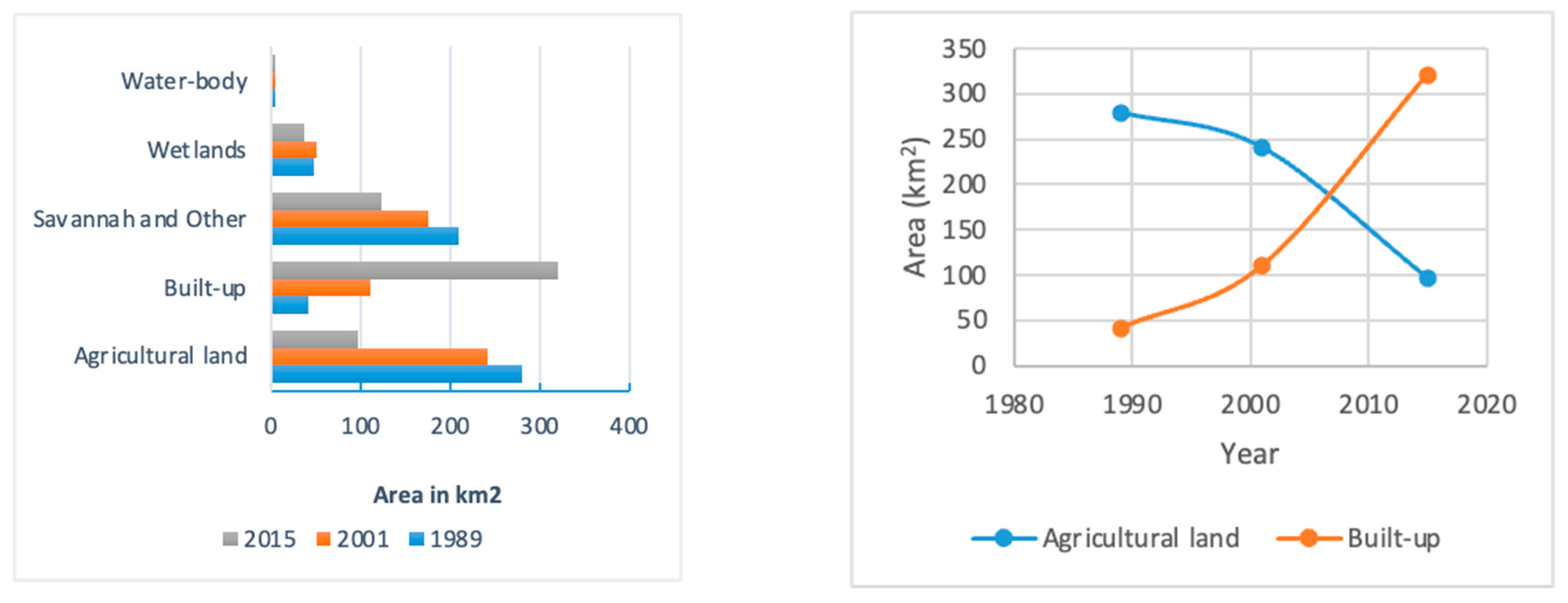
3.3. The Extent of Agricultural Land Conversion to Urban Use in Large and Small Urban Centers (Gains and Losses)

Kampala experienced a 32% decline in agricultural land between 1989 and 2015 (see Table 3), while Mbarara experienced a 20% decline between 2002 and 2016 (see Table 4).
LULC categories are affected differently by the land-use pressure, as some land categories persist on the landscape because of their perceived limitations and due to the high costs required for developing them. To assess the tendency of the land category to undergo transition in the landscape, the metrics of gain-to-persistence (gp) and loss-to-persistence (lp) ratios can be used (Table 5).
In Table 5, the values in the loss-to-persistence (lp) column indicate the vulnerability of a category to be lost to other categories, whereas the values in the (gain-to-persistence (gp) column indicate the tendency of a category to gain from other categories.
The lp ratio for the built-up category was less than one in both Kampala and Mbarara. Thus, the built-up category had a higher tendency to persist than to lose and this is expected since LULC transitions to built-up are generally permanent. On the other hand, the built-up category in both cities had a gp value greater than one, an indication of the irreversible nature of the cover changes involving the built-up category.
Agricultural land has, generally, gp and lp values greater than one in all the analyzed years, except for the period between 1989 and 2001. Thus, agricultural land experienced higher swapping change as a result of experiencing both a higher tendency to lose and to gain from other categories than to persist (Table 5),
One of the key observations is that agricultural land had a negative net change-to-persistence ratio (np) = gp − lp, throughout the study period, which implies a higher tendency to lose than to persist in the landscape. Meanwhile, the built-up category had positive values of np due to a lower tendency to lose than to persist.
Figure 4 shows the spatial distribution of the agricultural LULC class changes in Kampala between 1989 and 2015. Agricultural land had a high persistence and gain between 1989 and 2001; however, between 2001 and 2015 agricultural land had high loss and low gains. This is generally attributed to the high urban population increase and increased pressure on the land for housing development during this period. As shown in Figure 4, agricultural land experienced noticeable gains in areas far from the city centers, in peri-urban areas, and persistence was higher in the period between 1989 and 2001 compared to the period between 2001 and 2015.
Agricultural land in Mbarara generally experienced significant levels of persistence between 2002 and 2016 (Figure 5). The losses are visibly concentrated near the city center, while gains can be observed far away from the urban centers along the city boundaries, like what was observed in Kampala (Figure 4). Agricultural land gains in peri-urban areas can be attributed to the conversion of open green spaces to agricultural land. Agricultural land losses tend to concentrate along major roads, where building activities are more intense. Overall agricultural land in Mbarara remained constant over the study time periods because of persistence plus gains, which offset the observable losses.
A comparison of the agricultural LULC spatial patterns of change reveals that Mbarara had a higher persistence in the agricultural land category compared to Kampala (Figure 4 and Figure 5). Small urban centers tend to have high agricultural land persistence compared to big cities. Between 1989 and 2001, when Kampala was the same size as present-day Mbarara, it exhibited higher persistence of agricultural land compared to when it had enlarged between 2001 and 2015.

3.4. Urban Expansion on Fragile Ecosystems, including Wetlands and Forests

Table 6 reveals the dominant signals of landscape transitions, indicating whether the transitions among the categories are systematic or random in nature.
The row totals show the proportion of the landscape that was under that category in the initial year time 1 (t1 is the year 2001) while the column totals depict the proportion of the landscape under that category at time 2 (t2 is the year 2015). For instance, in t1 the built-up land was only 18.92% (built-up row total) but this increased to 55.10% (built-up column total) indicating a net landscape gain of 37.2% (equivalent to 191.22% increase).
The landscape changed from 8.83% to 6.40% wetlands, which implies a net landscape loss of 2.4% (equivalent to a 27.2% net decrease in wetlands). Savannah and other decreased from 30.15% to 21.15% (equivalent to a 29.85% net decrease of savannah and other land), while agricultural land changed from 41.41% to 16.69% (equivalent to a 59.70% net loss of agricultural land).
The disparity between observed and expected gains or losses is indicative of systematic processes. That is, if the observed value is greater than both the expected gain value and expected loss value, then it is a systematic process.
Based on Table 6, the most systematic process in the landscape involved the transition from agricultural land to built up. The observed 24.81% is greater than the expected gain of 19.01% (indicating systematic gain), and the observed 21.81 is greater than the expected loss of 10.81% (indicating systematic loss). Thus, it had both systematic gain and systematic loss, which is a condition for transition to be classified as a systematic process of change. This accounted for 24.81%of the total landscape change between 2001 and 2015. Specifically, 59.91% of agricultural land was converted to the built-up category in a systematic process.
The second systematic transition, though on a smaller scale, was from wetlands to savannah and the other category. The observed value was 2.4% greater than the expected gain of 1.35% (systematic gain), and the observed value of 2.4% was greater than the expected loss value of 2.05% (systematic loss). This accounted for 2.4% of the landscape change. Specifically, 27.18% of the wetlands transitioned to savannah and other between 2001 and 2015 through a systematic process of change.
Other forms of change involved a combination of systematic gain and random loss, leading to overall classification as a random process of change. Notably, this kind of transition occurred between agricultural land and the savannah and other categories. Savannah and other LULC classes gained systematically from agricultural land (observed value 6.92% greater than the expected gain value of 4.50%), but the observed value of 6.92% was less than the expected loss value of 11.68%, meaning agricultural land did not lose systematically to the savannah and other LULC categories. Similarly, agricultural land was gained systematically from the savannah and other LULC classes (the observed value of 7.94% was greater than the expected gain value of 6.35%, but the observed value of 7.94% was less than the expected loss of 17.22%), implying savannah and other LULC classes did not lose systematically to agricultural land. This means that there was no systematic transition between agricultural land and savannah and other LULC classes (Table 6). This presents a situation characterized by simultaneous systematic gains and random losses, a common form of land-use transitions in the study area.
Table 7 shows the landscape transition of different categories between 2002 and 2016 in Mbarara. Like in Kampala, built up gained systematically from agricultural land, and at the same time, agricultural land lost systematically to the built-up category. This indicates the transition of 14.72% of the landscape was because of a systematic process of change rather than a random process of change.
Another systematic process of landscape change was between other and built-up categories. Built up gained systematically from the other category, and the other category lost systematically to built up, based on the differences between observed values and expected values from the random process of gain or loss (Table 7).
Other forms of transition involved agricultural, savannah, grazing land, and other. For instance, agricultural land gained systematically from grazing land, but grazing land did not lose systematically to agricultural land. Similarly, agricultural land gained systematically from savannah, but savannah did not lose systematically to agricultural land. Also, grazing land and savannah lost systematically to built up, but built up did not gain systematically from these categories.

4. General Discussion

4.1. Urbanization Rate in Large and Smaller Urban Centers

This study found that the annual urbanization rate, measured by built-up area expansion, was 1.76% in Mbarara, a smaller urban center, and 1.85% in Kampala, a larger urban center. This implies that the percentage of the landscape converting to built-up areas annually was quite similar in both cities.
Uganda, being one of the least urbanized countries in the world [62], has concentrated most of its urban growth in Kampala and regional centers like Mbarara, which boast of a relatively better infrastructural development. Hitherto, Kampala is of a significant economic importance, housing over 80% of Uganda’s industries. This concentration of economic activity attracts many people, leading to a high urbanization rate despite expectations of faster growth in smaller cities like Mbarara. Similar findings of rapid urbanization were reported in Kumasi, Ghana where urbanization doubled in 10 years [63], while Kisangani, DRC grew by 8.7% [64]. These findings indicate different trends from what was reported in developed countries. For example, studies in China observed that smaller cities had expanded more than medium and big cities [65]. If these results are projected at the current growth rate, the overall national urban areas will double in less than 30 years.
The global annual urban expansion rate is estimated at 3.66% with built-up area expected to double in 25 years [18]. The driving factors behind this rapid urbanization are multifaceted. Rural-to-urban migration remains a primary catalyst, driven by the substantial opportunity gap between rural and urban areas. As rural residents seek better economic opportunities, they migrate to urban centers, accelerating urban growth. High natural population growth is another significant factor. Uganda has a youthful demographic, with most of the population below 30 years of age. This demographic trend suggests continued exponential population growth, which will further fuel urbanization. Additionally, improvements in healthcare systems have increased life expectancy, contributing to overall population growth. Unlike more densely built urban areas in other parts of the world, Uganda’s cities predominantly feature low-rise buildings. This means that population increases result in horizontal expansion into peri-urban areas, often at the expense of agricultural land, forests, and wetlands.

4.2. The Extent of Agricultural Land Conversion to Urban Use in Large and Small Urban Centers (Gains and Losses)

Urban expansion in both Mbarara and Kampala is driving significant changes in land use and land cover (LULC). This study found that 48% of new built-up areas in Mbarara and 45% in Kampala have emerged on previously agricultural land. Most importantly, the conversion of agricultural land to the built-up category in both locations was systematic. This means that the built-up category is more likely to expand into agricultural land than any other category. The preference for agricultural land is rooted in the history of these cities, which started as settlements in areas suitable for farming activities. The values of loss to persistence (lp) of agricultural land were high, which indicates that it is more likely to lose to other categories than to persist between classifications [35,38]. Since most SSA cities quickly metamorphosed from agrarian communities that had settled on fertile lands, it is highly likely that the observed LULC is occurring on fertile land [66]. Consequently, only 16.7% of the initial agricultural land in Kampala had persisted during the study period, which generally reveals the low static state of the landscape between time 1 and time 2 [56]. This means that more than 80% of the initial agricultural land had been lost, and the level of existing agricultural land was largely because of a high proportion of swapping change in which farmers open up new farmlands on marginal land [67]. Our findings align with similar studies across SSA. For instance, in Tamale, Ghana [68], it was found that 61.3% of the urban growth occurred on previously agricultural land. In Osun State and Makurdi, Benue State, about 60% of urban growth was on agricultural land [69,70]. In Sebougou, Mali, more than 50% of the previous agricultural land has been lost to built up [71].
The conversion of agricultural land to built-up areas, including infrastructure such as roads, parking lots, and pavements, represents a significant loss in agricultural productivity. As farmers are displaced from their lands near urban centers, they move to peri-urban areas, often encroaching on wetlands and forests. This relocation leads to the cultivation of marginal lands, whose productivity is uncertain, posing a sustainability challenge. Despite these challenges, some agricultural land persists in urban areas, especially in smaller urban centers like Mbarara, where backyard gardens and public open spaces remain [72]. This persistence is higher in smaller cities compared to larger ones, where urban sprawl is more extensive.
The current high annual rate of agricultural decline, despite farmers’ coping mechanisms, suggests that the loss of agricultural land is far greater than the gains. This study projects that, if the urbanization rate continues unchecked, agricultural land in these regions could decrease by 90% by 2030. This significant reduction poses a severe threat to food security and agricultural sustainability.
Smaller urban centers experience a higher swap type of change than large cities. For example, over 34% of the landscape change in Mbarara involving agricultural land use was a result of swapping. Swap change in Mbarara involving agricultural land is associated with the farmers’ desire to replace land for growing crops when the previous one is lost to urban growth. LULC categories that are very important to the livelihoods of the residents have a high tendency to experience swap change, as the need for replacing lost proportion is high. For example, in Mbarara, grazing lands gained from savannah and other land-use classes experienced high swap change despite being vulnerable to conversion into agricultural land. High swap change in grazing land is attributed to the importance of cattle grazing in this region known as Uganda’s cattle corridor [73].

4.3. Urban Expansion on Fragile Ecosystems, Including Wetlands and Forests

The study found that built-up areas were expanding, while other land-use categories were facing a drastic decline. For instance, in Kampala, 29.3% of wetlands had been converted to the built-up category, while in Mbarara, 15% of wetlands were converted to built up between 2002 and 2016. One of the most important ecosystems is systematically being converted to savannah and other LULC classes, and 6.2% of wetlands have experienced encroachment (Table 3). Previous studies on LULC transition generally show similar trends. Urban expansion was reported to largely target ecologically sensitive lands like wetlands, forests, and agricultural land [13,19,20,21,22].
In Kampala, 13.6% of the wetlands were converted to agricultural land. This could be attributed to the loss of agricultural lands to built-up ones, which leads to the encroachment of forest cover and wetlands for replacement. Also, wetlands had transitioned systematically to savannah and other. The conversion of wetlands to savannahs could be a result of the over-exploitation of wetland resources beyond their natural rejuvenation potential because of population pressure emanating from urbanization. A similar study in Ghana reported higher wetland loss of 18% in coastal urban areas between 2002 and 2017 [33], and another study in the US found that 26% of the wetlands had been degraded [74]. The conversion of wetlands to agricultural land is on the rise as farmers who lose their land due to a lack of alternative employment usually make desperate attempts to replace lost agricultural land.
Wetlands, which are critical for ensuring the ecological integrity of cities, and are vital components of air and water quality, have been compromised due to unregulated rapid urbanization, putting the public health at a great risk. Thus, the destruction of wetlands, which act as buffers and filter water and air, leads to both air and water pollution. Whereas the likelihood of conversion of water bodies to other land-cover types is practically impossible, the quality of air and water around unregulated urbanizing cities is of major concern. As natural habitats to several plant and animal species, wetlands also provide economic value by acting as a source of food and raw materials for the local craft industry. Therefore, considering these vital roles and the apparent threat from urban sprawl, it is important to find ways to establish policies to ensure sustainable land management.
In addition, the loss of agricultural lands leads to the encroachment of forest cover for replacement. The current study reveals that about 27% of the savannah and forests around Kampala were lost between 1989 and 2015 (Table 3). Similar studies show higher losses. For instance, in Ebonyi state (Nigeria), forest cover declined by 50% between 1996 and 2018 [39]. The destruction of tree cover because of urban expansion has already exacerbated the effect of climate change in this region. This is evidenced by the increased incidences of floods that lead to the destruction of property worth millions of dollars and, in several cases, loss of lives as well [37,75]. It has been observed that the occurrence and intensity of floods in major cities of SSA have increased significantly compared to before, when the extent of urbanization was low [34,76]. Recent floods in Lagos, Nigeria, were attributed to unregulated urban growth [24]. Similar studies in Uganda show that urbanization is also expected to increase the demand for housing and deforestation and wetland encroachment will increase in order to provide timber for building construction, which will affect hydrologic processes [34]. The deleterious impact of forest and wetland destruction around urban centers affects the microclimate and, consequently, lowers the quality of air around urban centers, which is likely to negatively affect people’s health [3]. In addition, the rise in carbon dioxide associated with the LULC will lead to an increase in the effects of climate change, which is expected to hit this region hardest [22].
Previous studies have also provided evidence of the positive link between the loss of arable lands to urban uses and food insecurity in this region. For instance, national reports across SSA show a consistent decline in crop production around several cities, due partly to the impacts of climate change, land degradation, and, partly, to the loss of fertile lands to urban land-use forms because of urban expansion [77]. As a consequence of climate change, land degradation and the loss of large areas of cropland due to conversion to urban uses, many countries that were previously classified as predominantly self-sufficient in food production are now net grain importers of food [34]. Food insecurity is likely to rise as the cost of living in crowded cities is increasing spontaneously. Food prices are also expected to triple in just ten years, which will expose more than half of the population in this region to severe food shortages [1]. Also, studies have reported a significant positive relationship between urbanization and poverty in this region [78].
Urban-planning authorities need to implement stringent policies that protect urban forests and fragile ecosystems from being overexploited as the urban population grows. Urban sprawl and the depletion of the natural landscape in the metropolis are generally taking place within the context of weak legal and institutional regimes [6,13,25,78]. A study in Abuja (Nigeria), for example, found a mismatch between the urban land-use plan and the existing urban cover [23]. A similar study in Lusaka (Zambia) reveals unregulated rapid urban growth between 2000 and 2015 [17]. Another study in South Africa found that 48% of wetlands have low levels of protection from encroachment [79]. This implies urban growth in SSA is not following urban-planning policies, and that is leading to encroachment on fragile ecosystems. Alternative sources of energy should be sought to minimize the current rate of urban forest destruction. There should be tree-planting programs like those in Ethiopia that target the replacement of destroyed forests. Countries that have embarked upon tree-planting programs need to ensure that the planted trees are protected against illegal exploitation. The need to address the problem of deforestation should involve educational programs to raise awareness of the impact of deforestation and ensure that the public is involved in environmental protection.

4.4. Possible Measures to Solve Urban-Sprawl Problems

Our findings indicates that urbanization, as typified by the expansion of built-up area, comes at a cost on agricultural food production and the loss of ecologically sensitive ecosystems in SSA. There is an urgent need to arrest and reverse this trend so as to prevent food insecurity and lost of vital ecosystem services and habitat for native flora and fauna. The implementation of the following recommendations will help to ammeriolate the aforementioned issues associated with uregulated urban sprawl:
  • Develop and enforce comprehensive urban planning and zoning regulations to manage urban expansion effectively. Unregulated urban growth leads to encroachment on ecologically sensitive areas, such as agricultural lands, wetlands, and forests. Implementing and enforcing zoning laws can help guide sustainable urban development, preserving vital natural resources and reducing environmental degradation;
  • Invest in rural development programs to reduce the rural–urban migration pressure. The significant rural–urban opportunity gap drives migration to cities like Kampala and Mbarara, contributing to urban sprawl. By improving rural infrastructure, healthcare, education, and economic opportunities, policymakers can make rural areas more attractive and reduce the rate of urban migration;
Encourage sustainable agricultural practices and effective land-use management to balance urban growth and agricultural productivity. Protecting agricultural lands from urban encroachment is crucial for food security and environmental sustainability. Sustainable agricultural practices can enhance land productivity and resilience, reducing the need for expanding farmland into urban areas.

4.5. Limitations of the Study

We note that the findings of this study are limited by the quality of the aerial and satellite images acquired from different years and platforms and the accuracy of our interpretation and classification scheme. Therefore, the findings of this study should be interpreted within the bounds of these limitations, which include:
  • Land-use and land-cover (LULC) image classification lacks direct information on the socio-economic and demographic factors driving these changes, requiring integration with other data sources for comprehensive analysis;
  • The spatial resolution of satellite imagery limits the ability to detect fine-scale changes in land use and land cover (LULC), as most of the agricultural land in this region is fragmented and farming is conducted on a small scale. Higher-resolution images would be required for more accurate classifications, but they can be costly and less frequently available;
  • Despite the relatively high overall classification accuracy, this study is limited by the use of medium (30 m) resolution Landsat imagery. Such resolution poses some challenges in terms of the ability to identify informal settlements, mixed land uses, and sub-categories of the major LULC types. There is, therefore, the need to explore the use of a much higher resolution satellite imagery, such as the 10 m Sentinel 2 data. A higher resolution imagery will not only increase the accuracy of the LULC classification but also improve our understanding of the contribution of informal settlements to the densification of relatively unplanned urban centers, such as those in this study. Also, the accuracy of our LULC classification could be improved further by using machine-learning algorithms, such as deep learning and random forest models for classification. Furthermore, there is a need to quantify the uncertainty associated with our data analyses at the pixel level to provide some sort of confidence to potential users of our maps;
  • Urban centers in developing countries have several bare lands, which makes it difficult for classification algorithms to distinguish between different types of built-up areas and bare soil accurately.

5. Conclusions and Future Research

In this study, we have examined urban growth dynamics in Uganda, focusing on the Kampala and Mbarara regional centers as representative case studies. Unlike most conventional LULC classification studies focusing on SSA, we incoporated a suite of landscape transitions metrics in our assessment of urban growth, broadening our understanding of the dynamics of urban sprawl. Some key findings from this study and the direction of future research direction are detailed below.
  • The findings reveal a substantial expansion of built-up areas in both cities over the respective study periods. Kampala expanded nearly eightfold from 1989 to 2015, while Mbarara increased fivefold from 2002 to 2016. Notably, a significant portion of this urban growth is occurring at the expense of agricultural land, with more than half of the expansion encroaching upon such vital resources;
  • Compensatory gains in agricultural land, primarily through the conversion of other land-cover categories, such as savannahs, forests, and wetlands, highlight the dynamic nature of land-use changes, particularly in peri-urban and surrounding rural areas. However, the absence of stringent regulations governing urban development, coupled with the prevalence of diverse formal and informal land-tenure systems, portends a continued encroachment of urbanization on agricultural land in the region;
  • While the precise quantitative impact of urban growth on agricultural production and ecosystem integrity remains challenging to ascertain, our study underscores the critical importance of understanding both the losses and gains in agricultural land for sustainable urban growth management. Importantly, the acquisition of new agricultural land from ecologically sensitive areas like wetlands and forests raises concerns not only about productivity but also about environmental conservation. The unchecked expansion of urban areas, coupled with the indiscriminate conversion of fragile ecosystems for agricultural purposes, poses significant long-term challenges, exacerbating the already pronounced impacts of climate change and threatening regional food security. Urgent collective action by policymakers, urban planners, and scientists is imperative to ensure sustainable urban growth-management practices.
While our study focused on Kampala and Mbarara, the observed patterns of urban growth are likely indicative of broader trends across Sub-Saharan Africa. Hence, this research serves as a catalyst for further investigations into the implications of agricultural land loss due to urban expansion, with particular emphasis on its ramifications for fragile ecosystems and food security in the region. Future research directions may include an exploration of the socio-economic implications of urbanization by integrating social and economic indicators into land-use and land-cover analysis. Additionally, assessing the quality of agricultural land lost to urbanization through overlay analysis with agricultural land suitability maps presents a promising avenue for deeper investigation into this multifaceted issue.

Author Contributions

Conceptualization, R.O.M. and T.F.A.B.; Methodology, R.O.M., T.F.A.B., S.U.U. and S.I.C.A.; Software, R.O.M. and S.U.U.; Formal analysis, R.O.M., S.U.U. and S.I.C.A.; Writing—original draft, R.O.M.; Writing—review & editing, T.F.A.B., S.U.U. and S.I.C.A.; Supervision, T.F.A.B. All authors have read and agreed to the published version of the manuscript.

Funding

This research received no external funding.

Data Availability Statement

The original Landsat data presented in this study are openly available in https://www.usgs.gov/landsat-missions/landsat-data-access (accessed on 3 May 2024). However, the authors have no authority to share the aerial photos used in this study.

Conflicts of Interest

The authors declare no conflict of interest.

References

  1. de Bruin, S.; Dengerink, J.; van Vliet, J. Urbanisation as driver of food system transformation and opportunities for rural livelihoods. Food Secur. 2021, 13, 781–798. [Google Scholar] [CrossRef] [PubMed]
  2. Luwa, J.K.; Bamutaze, Y.; Mwanjalolo, J.-G.M.; Waiswa, D.; Pilesjö, P.; Mukengere, E.B. Impacts of land use and land cover change in response to different driving forces in Uganda: Evidence from a review. Afr. Geogr. Rev. 2021, 40, 378–394. [Google Scholar]
  3. Petrişor, A.-I.; Hamma, W.; Nguyen, H.D.; Randazzo, G.; Muzirafuti, A.; Stan, M.-I.; Tran, V.T.; Aştefănoaiei, R.; Bui, Q.-T.; Vintilă, D.-F.; et al. Degradation of coastlines under the pressure of urbanization and tourism: Evidence on the change of land systems from Europe, Asia and Africa. Land 2020, 9, 275. [Google Scholar] [CrossRef]
  4. Angel, S.; Parent, J.; Civco, D.L.; Blei, A.; Potere, D. The dimensions of global urban expansion: Estimates and projections for all countries, 2000–2050. Prog. Plan. 2011, 75, 53–107. [Google Scholar] [CrossRef]
  5. Seto, K.C.; Woodcock, C.E.; Song, C.; Huang, X.; Lu, J.; Kaufmann, R.K. Monitoring land-use change in the Pearl River Delta using Landsat TM. Int. J. Remote Sens. 2002, 23, 1985–2004. [Google Scholar] [CrossRef]
  6. Xu, G.; Dong, T.; Cobbinah, P.B.; Jiao, L.; Sumari, N.S.; Chai, B.; Liu, Y. Urban expansion and form changes across African cities with a global outlook: Spatiotemporal analysis of urban land densities. J. Clean. Prod. 2019, 224, 802–810. [Google Scholar] [CrossRef]
  7. Bhanjee, S.; and Zhang, C.H. Mapping latest patterns of urban sprawl in Dar es Salaam, Tanzania. Pap. Appl. Geogr. 2018, 4, 292–304. [Google Scholar] [CrossRef]
  8. Msongaleli, B.; Nnko, H.J.; Peter, K.H.; Mubako, S. Characterizing the relationship between urban sprawl and water demand in Dodoma Urban District, Tanzania: 1992–2029. Urban Water J. 2023, 20, 1579–1591. [Google Scholar] [CrossRef]
  9. Kukkonen, M.O.; Muhammad, M.J.; Käyhkö, N.; Luoto, M. Urban expansion in Zanzibar City, Tanzania: Analyzing quantity, spatial patterns and effects of alternative planning approaches. Land Use Policy 2018, 71, 554–565. [Google Scholar] [CrossRef]
  10. Katyambo, M.M.; Ngigi, M.M. Spatial monitoring of urban growth using GIS and remote sensing: A case study of Nairobi metropolitan area, Kenya. Am. J. Geogr. Inf. Syst. 2017, 6, 64–82. [Google Scholar]
  11. Nyongesa, S.K.; Maghenda, M.; Siljander, M. Assessment of urban sprawl, land use and land cover changes in Voi Town, Kenya using remote sensing and landscape metrics. J. Geogr. Environ. Earth Sci. Int. 2022, 26, 50–61. [Google Scholar] [CrossRef]
  12. Omasire, A.K.; Kimondiu, J.M.; Kariuki, P. Urban sprawl causes and impacts on agricultural land in Wote town area of Makueni county, Kenya. Int. J. Environ. Agric. Biotechnol. 2020, 5, 631–635. [Google Scholar] [CrossRef]
  13. Abass, K.; Adanu, S.; Gyasi, R.M. Urban sprawl and land use/land-cover transition probabilities in peri-urban Kumasi, Ghana. West Afr. J. Appl. Ecol. 2018, 26, 118–132. [Google Scholar]
  14. Biney, E.; Boakye, E. Urban sprawl and its impact on land use land cover dynamics of Sekondi-Takoradi metropolitan assembly, Ghana. Environ. Chall. 2021, 4, 100168. [Google Scholar] [CrossRef]
  15. Osei, F.E.; Balogun, B.O.; Afrifa, C.G. Identifying and quantifying urban sprawl in the Greater Accra region of Ghana from 1985 to 2014. Int. J. Sci. Res. 2015, 4, 2793–2798. [Google Scholar]
  16. Kourouma, J.M.; Phiri, D.; Hudak, A.T.; Syampungani, S. Land use/cover spatiotemporal dynamics, and implications on environmental and bioclimatic factors in Chingola district, Zambia. Geomat. Nat. Hazards Risk 2022, 13, 1898–1942. [Google Scholar] [CrossRef]
  17. Simwanda, M.; Murayama, Y.; Phiri, D.; Nyirenda, V.R.; Ranagalage, M. Simulating scenarios of future intra-urban land-use expansion based on the neural network–Markov model: A case study of Lusaka, Zambia. Remote Sens. 2021, 13, 942. [Google Scholar] [CrossRef]
  18. Angel, S.; Parent, J.; Civco, D.L.; Blei, A.M. Making Room for a Planet of Cities; Lincoln Institute of Land Policy: Cambridge, MA, USA, 2011. [Google Scholar]
  19. Moisa, M.B.; Gemeda, D.O. Analysis of urban expansion and land use/land cover changes using geospatial techniques: A case of Addis Ababa City, Ethiopia. Appl. Geomat. 2021, 13, 853–861. [Google Scholar] [CrossRef]
  20. Murayama, Y.; Simwanda, M.; Ranagalage, M. Spatiotemporal Analysis of Urbanization Using GIS and Remote Sensing in Developing Countries. Sustainability 2021, 13, 3681. [Google Scholar] [CrossRef]
  21. Nduwayezu, G.; Manirakiza, V.; Mugabe, L.; Malonza, J.M. Urban Growth and Land Use/Land Cover Changes in the Post-Genocide Period, Kigali, Rwanda. Environ. Urban. ASIA 2021, 12 (Suppl. S1), S127–S146. [Google Scholar] [CrossRef]
  22. Obahoundje, S.; Diedhiou, A.; Ofosu, E.A.; Anquetin, S.; François, B.; Adounkpe, J.; Amoussou, E.; Kouame, Y.M.; Kouassi, K.L.; Bi, V.H.N.; et al. Assessment of spatio-temporal changes of land use and land cover over South-Western African basins and their relations with variations of discharges. Hydrology 2018, 5, 56. [Google Scholar] [CrossRef]
  23. Enoguanbhor, E.C.; Gollnow, F.; Nielsen, J.O.; Lakes, T.; Walker, B.B. Land cover change in the Abuja City-Region, Nigeria: Integrating GIS and remotely sensed data to support land use planning. Sustainability 2019, 11, 1313. [Google Scholar] [CrossRef]
  24. Koko, A.F.; Yue, W.; Abubakar, G.A.; Hamed, R.; Alabsi, A.A.N. Analyzing urban growth and land cover change scenario in Lagos, Nigeria using multi-temporal remote sensing data and GIS to mitigate flooding. Geomat. Nat. Hazards Risk 2021, 12, 631–652. [Google Scholar] [CrossRef]
  25. Sumari, N.S.; Cobbinah, P.B.; Ujoh, F.; Xu, G. On the absurdity of rapid urbanization: Spatio-temporal analysis of land-use changes in Morogoro, Tanzania. Cities 2020, 107, 102876. [Google Scholar] [CrossRef]
  26. Halefom, A.; Teshome, A.; Sisay, E.; Ahmad, I. Dynamics of land use and land cover change using remote sensing and GIS: A case study of Debre Tabor Town, South Gondar, Ethiopia. J. Geogr. Inf. Syst. 2018, 10, 165. [Google Scholar] [CrossRef]
  27. Bren d’Amour, C.; Reitsma, F.; Baiocchi, G.; Barthel, S.; Güneralp, B.; Erb, K.H.; Haberl, H.; Creutzig, F.; Seto, K.C. Future urban land expansion and implications for global croplands. Proc. Natl. Acad. Sci. USA 2017, 114, 8939–8944. [Google Scholar] [CrossRef] [PubMed]
  28. Vermeiren, K.; Adiyia, B.; Loopmans, M.; Tumwine, F.R.; Van Rompaey, A. Will urban farming survive the growth of African cities: A case-study in Kampala (Uganda)? Land Use Policy 2013, 35, 40–49. [Google Scholar] [CrossRef]
  29. Bradshaw, T.K.; Muller, B. Impacts of Rapid Urban Growth on Farmland Conversion: Application of New Regional Land Use Policy Models and Geographical Information Systems 1. Rural Sociol. 1998, 63, 1–25. [Google Scholar] [CrossRef]
  30. Fazal, S. Urban expansion and loss of agricultural land-a GIS based study of Saharanpur City, India. Environ. Urban. 2000, 12, 133–149. [Google Scholar] [CrossRef]
  31. Godfray, H.C.J.; Beddington, J.R.; Crute, I.R.; Haddad, L.; Lawrence, D.; Muir, J.F.; Pretty, J.; Robinson, S.; Thomas, S.M.; Toulmin, C. Food security: The challenge of feeding 9 billion people. Science 2010, 327, 812–818. [Google Scholar] [CrossRef]
  32. Alawamy, J.S.; Balasundram, S.K.; Hanif, A.H.M.; Sung, C.T.B. Detecting and analyzing land use and land cover changes in the region of Al-Jabal Al-Akhdar, Libya using time-series landsat data from 1985 to 2017. Sustainability 2020, 12, 4490. [Google Scholar] [CrossRef]
  33. Ekumah, B.; Armah, F.A.; Afrifa, E.K.A.; Aheto, D.W.; Odoi, J.O.; Afitiri, A.-R. Assessing land use and land cover change in coastal urban wetlands of international importance in Ghana using Intensity Analysis. Wetl. Ecol. Manag. 2020, 28, 271–284. [Google Scholar] [CrossRef]
  34. Gabiri, G.; Diekkrüger, B.; Näschen, K.; Leemhuis, C.; van der Linden, R.; Majaliwa, J.-G.M.; Obando, J.A. Impact of climate and land use/land cover change on the water resources of a tropical inland valley catchment in Uganda, East Africa. Climate 2020, 8, 83. [Google Scholar] [CrossRef]
  35. Braimoh, A.K. Random and systematic land-cover transitions in northern Ghana. Agric. Ecosyst. Environ. 2006, 113, 254–263. [Google Scholar] [CrossRef]
  36. Erenstein, O. Intensification or extensification? Factors affecting technology use in peri-urban lowlands along an agro-ecological gradient in West Africa. Agric. Syst. 2006, 90, 132–158. [Google Scholar] [CrossRef]
  37. Myers, G. Urbanisation in the Global South, in Urban Ecology in the Global South; Springer: Berlin/Heidelberg, Germany, 2021; pp. 27–49. [Google Scholar]
  38. Rawat, J.S.; Kumar, M. Monitoring land use/cover change using remote sensing and GIS techniques: A case study of Hawalbagh block, district Almora, Uttarakhand, India. Egypt. J. Remote Sens. Space Sci. 2015, 18, 77–84. [Google Scholar] [CrossRef]
  39. Obiahu, O.H.; Yan, Z.; Uchenna, U.B. Spatiotemporal analysis of land use land cover changes and built-up expansion projection in predominantly dystric nitosol of Ebonyi state, Southeastern, Nigeria. Environ. Chall. 2021, 4, 100145. [Google Scholar] [CrossRef]
  40. Simwanda, M.; Ranagalage, M.; Estoque, R.C.; Murayama, Y. Spatial analysis of surface urban heat islands in four rapidly growing African cities. Remote Sens. 2019, 11, 1645. [Google Scholar] [CrossRef]
  41. Rafa, M.; Moyer, J.D.; Wang, X.; Sutton, P. Estimating District GDP in Uganda. 2017. Available online: https://ssrn.com/abstract=3941446 (accessed on 9 November 2020).
  42. Thomas, B.E. On the growth of African cities. Afr. Stud. Rev. 1970, 13, 1–8. [Google Scholar] [CrossRef]
  43. Omolo-Okalebo, F.; Haas, T.; Werner, I.B.; Sengendo, H. Planning of Kampala city 1903–1962: The planning ideas, values, and their physical expression. J. Plan. Hist. 2010, 9, 151–169. [Google Scholar] [CrossRef]
  44. HRT. The Opening Up of British East Africa. J. R. Afr. Soc. 1904, 4, 44–55. [Google Scholar]
  45. Uganda Bureau of Statistics 2002, “The 2002 Uganda Population and Housing Census, Household Characteristics”, Analytical Report, October 2006, Kampala, Uganda. Available online: https://citeseerx.ist.psu.edu/document?repid=rep1&type=pdf&doi=764ed5f263cefa738b2ec0e3d51e6abed20d6824 (accessed on 9 November 2020).
  46. Prabha, K. Urban Agriculture in the Formal Economy and Land Use Planning in Kampala, Uganda. New York University: North York, ON, Canada, 1993. [Google Scholar]
  47. KCCA. Updating Kampala Structure Plan and Upgrading the Kampala GIS Unit; KCCA: Kampala, Uganda, 2012. [Google Scholar]
  48. UN-Habitat. State of the World’s Cities 2012/2013: Prosperity of Cities; Routledge: London, UK, 2013. [Google Scholar]
  49. Mertens, B.; Lambin, E.F. Land-cover-change trajectories in southern Cameroon. Ann. Assoc. Am. Geogr. 2000, 90, 467–494. [Google Scholar] [CrossRef]
  50. Bhaskaran, S.; Paramananda, S.; Ramnarayan, M. Per-pixel and object-oriented classification methods for mapping urban features using Ikonos satellite data. Appl. Geogr. 2010, 30, 650–665. [Google Scholar] [CrossRef]
  51. ERDAS, Erdas Imagine 2014; Hexagon Geospatial: Peachtree Corners, GA, USA, 2014.
  52. Congalton, R.G. A review of assessing the accuracy of classifications of remotely sensed data. Remote Sens. Environ. 1991, 37, 35–46. [Google Scholar] [CrossRef]
  53. Alo, C.A.; Pontius, R.G. Identifying systematic land-cover transitions using remote sensing and GIS: The fate of forests inside and outside protected areas of Southwestern Ghana. Environ. Plan. B Plan. Des. 2008, 35, 280–295. [Google Scholar] [CrossRef]
  54. Manandhar, R.; Odeh, I.O.; Pontius, R.G. Analysis of twenty years of categorical land transitions in the Lower Hunter of New South Wales, Australia. Agric. Ecosyst. Environ. 2010, 135, 336–346. [Google Scholar] [CrossRef]
  55. Pontius, R.G., Jr.; Huffaker, D.; Denman, K. Useful techniques of validation for spatially explicit land-change models. Ecol. Model. 2004, 179, 445–461. [Google Scholar] [CrossRef]
  56. Pontius, R.G., Jr.; Shusas, E.; McEachern, M. Detecting important categorical land changes while accounting for persistence. Agric. Ecosyst. Environ. 2004, 101, 251–268. [Google Scholar] [CrossRef]
  57. Mas, J.F. Monitoring land-cover changes: A comparison of change detection techniques. Int. J. Remote Sens. 1999, 20, 139–152. [Google Scholar] [CrossRef]
  58. Singh, A. Review article digital change detection techniques using remotely-sensed data. Int. J. Remote Sens. 1989, 10, 989–1003. [Google Scholar] [CrossRef]
  59. Schuster, C. A note on the interpretation of weighted kappa and its relations to other rater agreement statistics for metric scales. Educ. Psychol. Meas. 2004, 64, 243–253. [Google Scholar] [CrossRef]
  60. Sim, J.; Wright, C.C. The kappa statistic in reliability studies: Use, interpretation, and sample size requirements. Phys. Ther. 2005, 85, 257–268. [Google Scholar] [CrossRef] [PubMed]
  61. McHugh, M.L. Interrater reliability: The kappa statistic. Biochem. Medica 2012, 22, 276–282. [Google Scholar] [CrossRef]
  62. Sakketa, T.G. Urbanisation and rural development in sub-Saharan Africa: A review of pathways and impacts. Res. Glob. 2023, 6, 100133. [Google Scholar] [CrossRef]
  63. Sumbo, D.K.; Anane, G.K.; Inkoom, D.K.B. ‘Peri-urbanisation and loss of arable land’: Indigenes’ farmland access challenges and adaptation strategies in Kumasi and Wa, Ghana. Land Use Policy 2023, 126, 106534. [Google Scholar] [CrossRef]
  64. Balandi, J.B.; Hulu, J.P.P.M.T.; Sambieni, K.R.; Sikuzani, Y.U.; Bastin, J.-F.; Musavandalo, C.M.; Nguba, T.B.; Molo, J.E.L.; Selemani, T.M.; Mweru, J.-P.M.; et al. Urban Sprawl and Changes in Landscape Patterns: The Case of Kisangani City and Its Periphery (DR Congo). Land 2023, 12, 2066. [Google Scholar] [CrossRef]
  65. Tan, M.; Li, X.; Xie, H.; Lu, C. Urban land expansion and arable land loss in China—A case study of Beijing–Tianjin–Hebei region. Land Use Policy 2005, 22, 187–196. [Google Scholar] [CrossRef]
  66. Beauchemin, C.; Bocquier, P. Migration and urbanisation in Francophone West Africa: An overview of the recent empirical evidence. Urban Stud. 2004, 41, 2245–2272. [Google Scholar] [CrossRef]
  67. Rattray, A.; Ierodiaconou, D.; Monk, J.; Versace, V.; Laurenson, L. Detecting patterns of change in benthic habitats by acoustic remote sensing. Mar. Ecol. Prog. Ser. 2013, 477, 1–13. [Google Scholar] [CrossRef]
  68. Naab, F.Z.; Dinye, R.D.; Kasanga, R.K. Urbanisation and its impact on agricultural lands in growing cities in developing countries: A case study of Tamale in Ghana. Mod. Soc. Sci. J. 2013, 2, 256–287. [Google Scholar]
  69. Lasisi, M.; Popoola, A.; Adediji, A.; Adedeji, O.; Babalola, K. City expansion and agricultural land loss within the peri-urban area of Osun State, Nigeria. Ghana J. Geogr. 2017, 9, 132–163. [Google Scholar]
  70. Naab, F.Z.; Dinye, R.D.; Kasanga, R.K. Urbanisation and its impact on agricultural lands in growing cities in developing countries: A case study of Makurdi, Benue State Nigeria. Mod. Soc. Sci. J. 2020, 5, 41–58. [Google Scholar]
  71. Coulibaly, B.; Li, S. Impact of agricultural land loss on rural livelihoods in peri-urban areas: Empirical evidence from Sebougou, Mali. Land 2020, 9, 470. [Google Scholar] [CrossRef]
  72. Torquebiau, E. Are tropical agroforestry home gardens sustainable? Agric. Ecosyst. Environ. 1992, 41, 189–207. [Google Scholar] [CrossRef]
  73. Ndumu, D.B.; Baumung, R.; Hanotte, O.; Wurzinger, M.; Okeyo, M.A.; Jianlin, H.; Kibogo, H.; Sölkner, J. Genetic and morphological characterisation of the Ankole Longhorn cattle in the African Great Lakes region. Genet. Sel. Evol. 2008, 40, 467–490. [Google Scholar] [PubMed]
  74. McCauley, L.A.; Jenkins, D.G.; Quintana-Ascencio, P.F. Isolated wetland loss and degradation over two decades in an increasingly urbanized landscape. Wetlands 2013, 33, 117–127. [Google Scholar] [CrossRef]
  75. Mazeka, B.; Phinzi, K.; Sutherland, C. Monitoring Changing Land Use-Land Cover Change to Reflect the Impact of Urbanisation on Environmental Assets in Durban, South Africa, in Sustainable Urban Futures in Africa; Routledge: London, UK, 2021; pp. 132–158. [Google Scholar]
  76. Finn, B.M.; Cobbinah, P.B. African urbanisation at the confluence of informality and climate change. Urban Stud. 2023, 60, 405–424. [Google Scholar] [CrossRef]
  77. Saghir, J.; Santoro, J. Urbanization in Sub-Saharan Africa. In Meeting Challenges by Bridging Stakeholders; Center for Strategic & International Studies: Washington, DC, USA, 2018. [Google Scholar]
  78. Sulemana, I.; Nketiah-Amponsah, E.; Codjoe, E.A.; Andoh, J.A.N. Urbanization and income inequality in Sub-Saharan Africa. Sustain. Cities Soc. 2019, 48, 101544. [Google Scholar] [CrossRef]
  79. Adeeyo, A.O.; Ndlovu, S.S.; Ngwagwe, L.M.; Mudau, M.; Alabi, M.A.; Edokpayi, J.N. Wetland Resources in South Africa: Threats and Metadata Study. Resources 2022, 11, 54. [Google Scholar] [CrossRef]
Figure 1. Location of Kampala and Mbarara urban centers in Uganda. (Source: https://energy-gis.ug/gis-maps (accessed on 20 November 2020)).
Land 13 01056 g001
Figure 2. Schematic flow of image analysis of land-use classification (Source: authors’ illustration).
Land 13 01056 g002
Figure 3. Land-use and cover changes between 1989 and 2015 in Kampala.
Land 13 01056 g003
Figure 4. Gain, loss, and persistence for agricultural land 1989 to 2001 and 1989 to 2015, Kampala.
Land 13 01056 g004
Figure 5. Gain, loss, and persistence for agricultural land from 2002 to 2016 (Mbarara).
Land 13 01056 g005
Table 1. Extended land-cover transition matrix between 1989 and 2015.
19892015
Urban and Built UpWater BodiesWetlandsSavannah and OtherAgricultural LandTotal 1989Loss
Urban and built upR11R12R13R14R15R1+R1+ − R11
Water bodiesR21R22R23R24R25R2+R2+ − R22
WetlandsR31R32R33R34R35R3+R3+ − R33
Savannah and otherR41R42R43R44R45R4+R4+ − R44
Agricultural landR42R43R44R45R46R5+R5+ − R55
Total 2015R+1R+2R+3R+4R+51
GainR+1 − R11R+2 − R22R+3 − R33R+4 − R44R+5 − R55
Table 2. Overall and kappa accuracy of final LUCC maps of Kampala and Mbarara.
SensorDateSiteOverall Classification AccuracyKappa Index of Agreement
Landsat TM27 February 1989Kampala85.6%0.80
Landsat ETM+27 November 2001Kampala90.00%0.87
Landsat OLI/TIRS27 February 2015Kampala89.9%0.86
Landsat ETM+13 May 2002Mbarara92.0%0.89
Landsat OLI/TIRS5 February 2016Mbarara93.48%0.90
Table 3. Summary of landscape changes between 1989 and 2015 for Kampala.
Total 1989Total 2015PersistenceGainLossGain–LossSwapAbsolute Value of Net ChangeTotal Change
------------------------------------------------------------%-----------------------------------------------------------------------
Built up7.1455.106.4448.660.6970.211.3947.9649.35
Waterbody0.680.660.640.020.040.370.030.030.06
Wetland8.236.402.034.376.200.718.741.8310.57
Savannah35.9221.158.9212.2327.000.4524.4614.7739.23
Agricultural48.0316.698.008.6940.030.2217.3731.3448.71
Total 2015100.00100.0026.0473.9673.961.0026.0047.9673.96
Table 4. Summary of landscape changes in Mbarara between 2002 and 2016.
Total 2002Total 2016PersistenceGainLossGain–LossTotal ChangeSwapAbsolute Value of Net Change
Built up6.3730.955.4925.450.8829.0226.331.7524.57
Agricultural 39.9232.0814.9917.0924.930.6942.0234.187.84
Grazing land19.7123.717.3816.3312.321.3228.6524.654.00
Stream1.061.250.400.850.661.281.521.330.19
Savannah25.629.754.365.3921.260.2526.6510.7815.87
Other7.322.260.721.546.590.238.133.085.05
Total 2001100.00100.0033.3566.6566.651.0066.6537.8828.77
Table 5. Gain-to-persistence and loss-to-persistence and net change-to-persistence ratios of built-up and agricultural land classes for Kampala and Mbarara.
Land Use/Land CoverGain-to-Persistence
(gp)
Loss-to-Persistence
(lp)
Net Change-to-Persistence
(np)
Swap (S)Net Change (nc)
(a) Kampala 1989–2001
Built-up2.340.262.082.9411.78
Agricultural land0.690.96−0.2733.886.62
(b) Kampala 2001–2015
Built-up2.080.062.022.0736.19
Agricultural land1.104.21−3.1117.4924.72
(c) Mbarara 2002–2016
Built-up4.630.164.471.7524.57
Agricultural 1.141.66−0.5234.187.84
Table 6. Inter-category percent of gains and losses between 2001 and 2015 (Kampala) *.
2015 Total 2001Loss
Urban and Built UpWater BodiesWetlandsSavannah and OtherAgricultural Land
2001
Built up17.880.000.050.360.6318.921.04
17.880.000.782.902.8224.396.51
17.880.010.110.390.5318.921.04
Waterbody0.020.640.020.010.000.690.05
0.320.640.030.110.101.200.55
0.010.640.000.010.020.690.05
Wetland2.590.012.642.401.208.836.20
4.050.002.641.351.329.366.73
1.290.052.642.052.818.836.20
Savannah and Other9.800.002.9810.446.9230.1519.71
13.840.001.2410.444.5030.0419.59
5.340.192.4910.4411.6830.1519.71
Agricultural land24.810.000.717.947.9441.4133.47
19.010.011.716.357.9435.0227.07
10.810.395.0417.227.9441.4133.47
Total 201555.100.666.4021.1516.69100.0060.46
55.100.666.4021.1516.69100.0060.46
35.321.2910.2930.1222.99100.0060.46
Gain37.220.013.7610.718.7560.46
37.220.013.7610.718.7560.46
0.000.000.000.000.000.00
* The number in bold is the actual percent of the landscape. The number in italics is the percent of the landscape that would be expected if the process of gain were random. The number in the normal font is the expected value if a random process of loss occurred (2001–2015). Systematic transitions are represented by percent numbers in red font.
Table 7. Inter-category percent of gains and losses between 2002 and 2016 (Mbarara) *.
2016 Total 2002Loss
Built UpAgricultural Grazing LandStreamSavannahOther
2002
Built up5.490.460.140.050.100.136.370.88
5.491.811.300.060.460.119.223.73
5.490.370.180.010.240.076.370.88
Agricultural 14.7214.996.460.162.860.7439.9224.93
10.8514.998.120.342.890.6637.8622.87
2.6414.998.180.4410.633.0439.9224.93
Grazing land3.956.177.380.251.760.2019.7112.32
5.365.617.380.171.430.3320.2712.89
0.986.137.380.163.931.1219.7112.32
Stream0.160.030.140.400.270.061.060.66
0.290.300.220.400.080.021.300.90
0.040.270.130.400.170.051.060.66
Savannah4.448.347.720.344.360.4125.6221.26
6.967.295.210.224.360.4324.4720.11
1.8211.415.630.304.362.0925.6221.26
Other2.192.101.860.060.390.727.326.59
1.992.081.490.060.530.726.876.15
0.452.841.400.081.820.727.326.59
Total 201630.9532.0823.711.259.752.26100.0066.65
30.9532.0823.711.259.752.26100.0066.65
11.4336.0122.911.3921.167.09100.0066.65
Gain25.4517.0916.330.855.391.5466.65
25.4517.0916.330.855.391.5466.65
25.4517.0916.330.855.391.5466.65
* The number in bold is the actual percent of the landscape. The number in italics is the percent of the landscape that would be expected if the process of gain were random. The number in the normal font is the expected if a random process of loss occurred (2002–2016). The systematic transitions are represented by percent numbers in red font.
Disclaimer/Publisher’s Note: The statements, opinions and data contained in all publications are solely those of the individual author(s) and contributor(s) and not of MDPI and/or the editor(s). MDPI and/or the editor(s) disclaim responsibility for any injury to people or property resulting from any ideas, methods, instructions or products referred to in the content.

