Article

The Identification, Spatial Distribution, and Reconstruction Mode of Abandoned Mining Areas

by
Viorel Gligor
1,
Emanuela-Adina Nicula
2,* and
Remus Crețan
3
1
Department of Regional Geography and Territorial Planning, Faculty of Geography, Babeş-Bolyai University, Clinicilor St. 5–7, 400006 Cluj-Napoca, Romania
2
Mountain Economy Center, “Costin C. Kirițescu” National Institute for Economic Research, Romanian Academy, Petreni St. 49, 725700 Vatra Dornei, Romania
3
Department of Geography, West University of Timişoara, Vasile Parvan Bv. no. 4, 300223 Timişoara, Romania
*
Author to whom correspondence should be addressed.
Land 2024, 13(7), 1107; https://doi.org/10.3390/land13071107
Submission received: 5 June 2024 / Revised: 18 July 2024 / Accepted: 19 July 2024 / Published: 22 July 2024
(This article belongs to the Special Issue Ecological Restoration and Reusing Brownfield Sites)

Abstract

:
The rehabilitation of abandoned mining sites is an increasingly pressing issue in the context of sustainable development. Recent research has emphasized the need for a holistic approach to the abandoned mining sites and their environmental rehabilitation. Based on field analysis, environmental assessments, satellite imagery processing and geographic information operations, this paper pushes forward the existing knowledge by conducting a comprehensive assessment of abandoned mining sites in the Romanian Carpathians and by proposing innovative and sustainable rehabilitation solutions. Our findings highlight that abandoned mining sites and their surrounding territories in the Romanian mountains have significant ecological imbalances and complex socio-economic issues. The findings also suggest that by adopting innovative, integrated, and sustainability-oriented approaches, territories affected by mining can be transformed into valuable and sustainable spaces to meet human needs. We conclude by presenting the importance of innovation in ecological reconstruction and spatial–functional reintegration of mining sites in mountain areas as a useful tool in making fair decisions, both in the context of implementing appropriate development policies as well as for the resilience and environmental sustainability of mining-affected mountain areas.

1. Introduction

Mining has been fundamental to human civilization, from Stone Age sites to the iron and coal mines of the Industrial Revolution, and now to materials critical for renewable energy. Mining and its products significantly bolster national economies, with mining value tripling in the past two decades [1]. Though mining operations have a limited spatial footprint, they cause significant local environmental effects, which vary with extraction techniques, deposit nature and scale, pollution control effectiveness, waste management, and land restoration strategies [2,3]. In Eastern Europe, including Romania, mining has a long history, significantly aiding economic development, job creation, infrastructure, local industries, and social welfare [4,5,6,7,8,9]. However, while mining offers societal benefits, it can cause land use conflicts [10,11] and negative impacts such as deforestation, erosion, contamination, water and air pollution, biodiversity loss, landscape degradation, community displacement, and issues related to mine abandonment and repurposing [12,13,14,15,16,17,18,19,20]. Ending mining operations impacts local economies, job prospects, and socio-economic growth, which are crucial for achieving Sustainable Development Goals (SDGs). Balancing SDG pillars—society, economy, and environment—is essential for sustainable mining initiatives [13,21].
Remediation and rehabilitation can positively affect environmental systems, making it crucial to restore degraded land sustainably [22,23,24]. Recently, mining companies are required to integrate sustainable development (SD) principles in post-mining restoration, aiming for environmentally and socially acceptable conditions [13,25,26]. The literature highlights various successful intervention methods globally [27,28,29]. Scientific discourse on post-mining land use includes restoration, reclamation, and rehabilitation [24,25,30,31]. Some former mining sites are unique ecosystems or cultural heritage monuments, protected or transformed into tourist attractions [32,33]. In Romania, geoecological reconstruction methods for mining-affected territories have developed over three decades, focusing on harmonizing natural and anthropogenic factors [34,35,36,37,38,39,40,41,42,43,44,45,46]. Similar studies in other Carpathian countries and globally offer effective practices [47,48,49,50,51]. Recreational activities and sustainable tourism are notable in former mining areas in the Czech Republic, Poland, and Slovakia. Globally, countries like Germany, the USA, the UK, India, Norway, Indonesia, Canada, Australia, Finland, and New Zealand have successfully converted industrial sites into tourist attractions, protecting and improving environmental conditions, preserving historical identity, and promoting cultural heritage, traditions, crafts, and economic development.
This paper aims to assess abandoned mining sites in the Romanian Carpathians and propose novel, sustainable remediation strategies using field surveys, environmental evaluations [52], satellite imagery, and GIS. Objectives include analyzing the current state of abandoned mining sites, identifying sustainable rehabilitation opportunities within the circular economy framework, and establishing investigation methodologies and research techniques. This involves spatial, proximity, multivariate, and raster analysis, optimizing methods for reintegrating decommissioned mining sites in mountainous areas for fair decision-making in spatial planning and integrated territorial analysis. Our research addresses these questions: RQ1. Can environmental sustainability be achieved post-mining? RQ2. Is a holistic approach needed for the ecological rehabilitation of abandoned mining sites? In addition, the study emphasizes innovation in the ecological restoration and spatial–functional reintegration of mining sites in mountainous terrains, crucial for equitable decisions, suitable development strategies, and enhancing resilience and environmental sustainability. This research contributes to national knowledge [13] and fills gaps in the international literature by offering a comprehensive perspective on the sustainable rehabilitation of abandoned mining sites, focusing on restoring degraded land in protected areas like Natura 2000 sites. Unlike studies focusing on specific regions or aspects of rehabilitation [53,54,55], this provides a thorough evaluation of the Romanian Carpathians’ abandoned sites. It integrates socio-economic and environmental aspects, addressing the need for comprehensive methodologies, highlighted by [56]. The study proposes transforming mining-affected areas into sustainable spaces meeting human needs, addressing socio-economic and environmental dimensions. Emphasizing innovation in ecological reconstruction and spatial–functional reintegration, it aligns with [57,58,59], advocating solutions-based approaches in ecological restoration, specifically for the Romanian Carpathians.
Our conclusions emphasize the relevance of sustainable development policies and resilience strategies for mining-affected mountain areas, crucial for fair decision-making and contributing to the broader discourse on sustainable development and resilience in mining regions, as discussed by Rodoloki et al. [53] and Alonzo et al. [54].

2. Materials and Methods

2.1. Study Area

The territory investigated overlaps with abandoned mining sites in the mountainous area of Romania, an area delimited according to the joint MADR-MDRAP Order no. 97/1332/2019 [60] (Figure 1). In the current geographical landscape, mining sites are primarily characterized by the existence of different types of anthropic geomorphic structures, due to the long-lasting transformations induced by extractive and processing activities in the mining industry. The specific forms with which they are identified in the territory are marked by the presence of quarries, tailings pits, underground galleries and voids, settling ponds, artificial embankments, and mounds. These, in turn, introduce a character of structural–functional discordance in the relationship of association with natural forms, marked both by the extension of the impact area of anthropogenic risks and by the potentially destructive effects induced on the components of local and regional environmental systems.
Research focused on the topic of landscape reconstruction and spatial–functional reintegration of mountain mining sites in the context of the circular economy has been extrapolated to the level of a case study with strong regional, national, and even international resonances. The area in question is the Apuseni Mountains, a region with multiple historical and cultural identity connotations [61], where gold and silver mining, which began in pre-Roman times, meets contemporary mining.
The regional system of the Apuseni Mountains constitutes a mountain subunit with distinct morphostructural and metallogenic features, which have given a specific socio-economic profile to the development of settlements in the mining areas. It is highlighted both by the historical value and the importance of the mineral resources contained/exploited, as well as by the order of magnitude expressed by the share of industrial-extractive surfaces and the density of mining sites. To all this must be added the impact of industrial mining activities on the local community and on the development profile of the entire mountain area.
The rationale for the multiscale regional approach in the analysis carried out is due, on the one hand, to the typological differences in mining anthropostructures (gold, silver, copper, uranium, refractory clay, bauxite, limestone, and coal), and, on the other hand, to the possibility of a gradual assessment of the elements and structures that make up the territorial systems in the areas affected by mining, given restricted access to data and information sets.
At the same time, the suitability of the territories for the implementation of the most appropriate spatial–functional reconstruction and reintegration measures was taken into account in accordance with the specificity of the local physical–geographical conditions and the harmonization of the strategic directions of regional development with the integrated spatial planning actions of the settlements in the mountain mining areas.

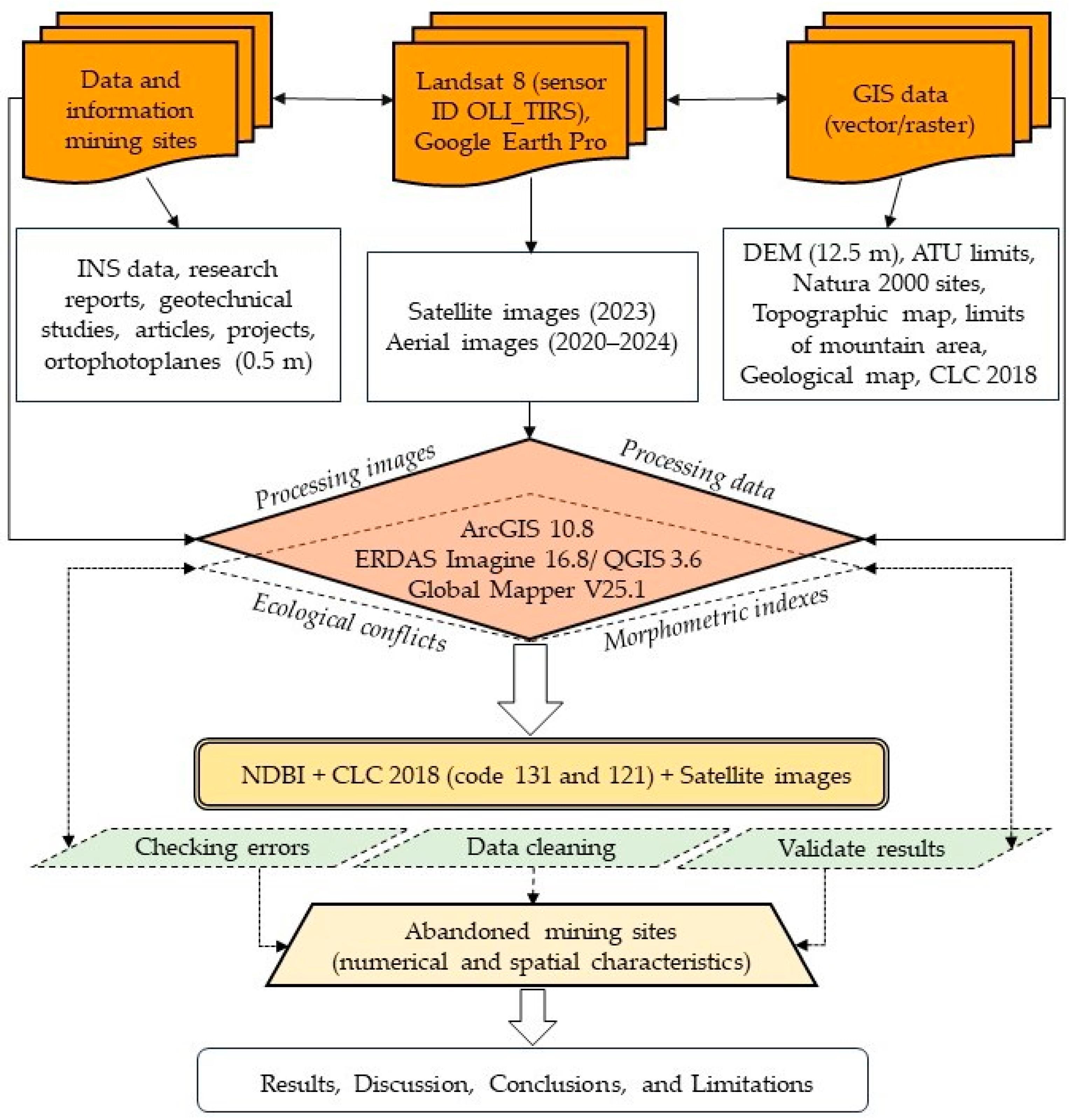
2.2. Research Methodology

Identifying an appropriate research methodology was crucial for obtaining quantitative and spatial information for the exploratory process [62]. The methodology involved collecting, sorting, processing, and interpreting data, map making, consulting public documents, and field research. The research required a multivariate analysis methodology divided into three stages. The first stage involved collecting and sorting data on the typology of abandoned mining sites according to the type of exploitation, highlighting the state parameters of post-mining territorial structures (quarries, mine galleries, settling ponds, tailings ponds, technological roads, processing plants). This information was primarily gathered through extensive analysis of scientific papers and reports from Web of Knowledge, ResearchGate, and Scopus. Additional data from technical reports, projects, and geotechnical studies of the Apuseni Mountains mining sites were also integrated. In the second phase, georeferencing images from external sources and advanced spatial and alphanumeric analyses were conducted, utilizing data from the Digital Elevation Model (DEM, 12.5 m). Landsat 8 satellite images were processed using ERDAS Imagine 16.8 software to calculate the normalized building differentiation index (NDBI) [63]:
NDBI = (TM6 − TM5)/(TM6 + TM5)
where TM5—near-infrared spectral band and TM6—mid-infrared spectral band.
The final result transformed images with values between −1 and +1 into descriptive data, facilitating the investigation of the territory based on the biophysical information obtained. Man-made and remodelled areas showed values between 0.01 and +0.99, while water bodies and vegetated areas had negative values between −1 and −0.01. GIS techniques complemented the research methods, allowing relational operations on different geographic data structures for maps, queries, and thematic editing. Using ArcGIS 10.8 software, vector layers corresponding to codes 131 (mineral extraction areas) and 121 (industrial or commercial units) were extracted from the Corine Land Cover dataset (2018). Visual checks revealed inaccuracies requiring data cleaning and error minimization. The accuracy of the vector layers was validated (Figure 2) using satellite images and by overlaying the Normalized Difference Building Index (NDBI) over images from Google Earth Pro datasets (image dates: 14 August 2020, 26 June 2021, 22 July 2022, and 31 March 2024).
Fifteen cases of non-compliance were corrected regarding land classification. After removing spatial representation errors, the layer with polygons corresponding to the mining sites was cropped from the vector mask of the mountain area and converted into points using the Feature to Point function (Data Management Tools). Kernel density was then calculated using ArcGIS 10.8 software to highlight the spatial distribution of abandoned mining sites in the mountain area of Romania (Figure 3).
Through this analysis, an estimate of the probability density was obtained according to the known points, with values very close to those given by the histograms. This spatial analysis identified several mining hotspots in the mountain areas of Hunedoara, Alba, Maramureș, Caraș-Severin, Bihor, Covasna, Harghita, Gorj, and Cluj. High-density areas are associated with ecological, socio-economic, and landscape impacts.
Through indirect methods, data were extracted in different formats, downloaded through platforms for geospatial products and GIS programs, facilitating comparative spatial analysis between abandoned mining sites and protected natural areas, ecological corridors, and water bodies. Using ArcGIS 10.8, the Intersect function (Analysis Tools > Overlay) identified points of ecological conflict within Natura 2000 sites. To identify the best reconstruction technologies for post-mining rehabilitation, the main morphometric indices (altitude, slope, and slope orientation) were analysed using a DEM (Digital Elevation Model) at 12.5 m resolution, produced by ALOS PALSAR with radiometric terrain correction (RTC). This analysis was applied at the regional level, with the Apuseni Mountains chosen as the case study due to the age of mining operations, the number of abandoned sites, population spread, exploitation complexity, and mineral resources.
The methodology applied in the third work phase was based on the results obtained in the previous stages (complex data processing, cartographic representations, diachronic assessments, and correlative-integrative analyses), all of which were favourable prerequisites for analysing the critical states induced by abandoned mining sites on protected natural areas, assessing the degree of resilience of socio-ecological systems and the possibilities of sustainable post-mining reconversion. The analytical approach aimed at geo-processing the data using GIS tools and generating multiple thematic layers on the distribution of mining sites by locality (Figure 4). Microscale analysis also involved investigations of mine water outlets, the current state of the mine sites in terms of reconstructive stages (in operation, with stopped activity, undergoing greening, greened) and post-mining stability of depositional and excavation morphology.
The data analytical approach identified the suitability of structures from industrial-mining activities for landscape reconversion and spatial–functional reintegration, developing integrated territorial rehabilitation models linking resource opportunities with social needs. Alternative solutions for sustainable reconstruction and spatial–functional reintegration were identified, aligning with the EU’s Circular Economy Package and Directive 2006/21/EC [64]. The sustainable development possibilities for mountain settlements with abandoned mining industries were also analysed, addressing risks such as depopulation, demographic ageing, decline of single-industry towns, socio-economic isolation, environmental degradation, and increasing poverty [65,66,67]. This approach and the structured datasets could serve as a reference for reconstructing abandoned mining sites and post-mining sustainable development.

2.3. Data Collection

The present research is based on the collection and structuring of a large volume of data and information from which the necessary and essential elements have been extracted, in the form of graphs, tables, or thematic layers, for detailed observations and multiscale analyses. Thus, the structure of the database used includes both Landsat satellite image processing and heterogeneous GIS thematic datasets, which provides the necessary consistency to achieve a methodological analysis framework that meets the objectives proposed in this research.
In order to build the database for the selection of the analysis variables, several classical and digital cartographic sources were used (Table 1), such as the geological map of Romania (1:200,000), topographic maps (1:25,000 and 1:50,000), orthophotos at 0.5 m resolution (for the year 2012, updated using Google Earth Pro 2020–2024 captures), and the CORINE Land Cover dataset (2018).
The management of field data, indirect observations, and intermediate and final results was carried out in a unified database management system, and the processing of this data was based on the use of different software. In addition, other sources of data obtained through comparative observations of the investigated mining sites in the mountainous area, in particular those in the Apuseni Mountains, were also used for the in-depth analysis of the territory. Among these, we can mention the data structures obtained from in situ observations and measurements, geographic information extracted through various operations using ArcGIS 10.8 software, analysis of studies and research projects carried out in the investigated area, and consultation of the normative–legislative framework in force.
The completion of the database was extrapolated for the whole mountain area of Romania by extracting the value sets of the parameters used from different cartographic supports (geomorphological, soil, and vegetation maps). The thematic layout types were used both in the spatial analysis process, carried out in the digital quantitative data collection stage, and for obtaining the information needed [68] for morphometric, morphodynamic, environmental, and landscape analyses.
The structuring and processing of the datasets thus obtained aimed to match the coverage area with the delineation and analysis of the biophysical parameters of the studied area. At the same time, the relational database also included the variables needed to assess anthropogenic intervention by industrial-mining activities on the mountain territorial system, as well as the inventory of abandoned mining sites and the mapping of risk processes with major environmental impact. The first structures imported into the database were those in vector format, brought in through the PostGIS Manager import/export application. Several thematic layers have been added through this application, which have been kept spatially re-referenced by filling the SRID field with the EPSG code 3844, corresponding to the official projection system of Romania (Stereo 1970).
The necessary theoretical criteria were also evaluated and substantiated to actively contribute to the systematization of the geospatial data workflow for abandoned mining sites in the mountain area. To this end, several geospatial data were collected and processed on the location of surface and underground mining perimeters, as well as the location of mining waste dumps, included in the category of tailings ponds and settling ponds.
The cartographic and satellite materials were georeferenced in Global Mapper V.25.1 and ArcGIS 10.8. The satellite images used in this analysis were downloaded by accessing the Landsat database [69], with the aim of ensuring that the months of capture (July–September) provided the most fitting possible clarity.
Another part of the indicators used in the research process was based on quantitative data obtained by accessing data sources and information held by various national institutions: the National Agency for Cadaster and Real Estate Publicity (ANCPI), the National Agency for Environmental Protection (ANPM), the National Institute for Statistics and Economic Studies (INSSE), the Geological Institute of Romania (IGR), and the Ministry of Agriculture and Rural Development (MADR).

3. Results

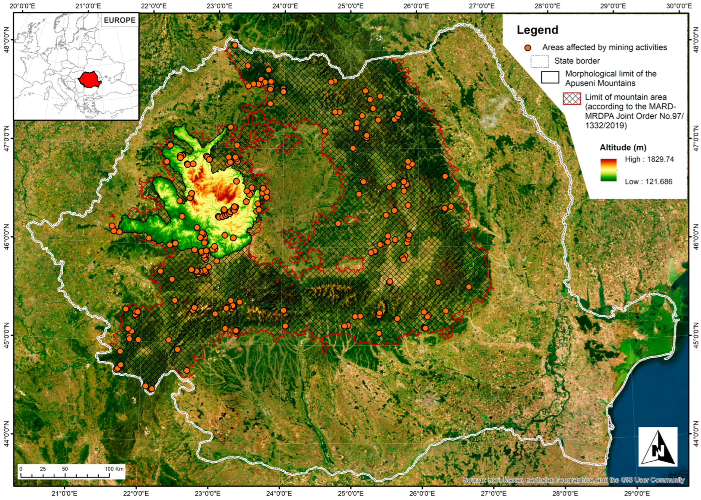
3.1. Mining Area Identification

The analyses carried out have provided a wealth of data and information on abandoned mining sites in Romania’s mountain area. The content elements were based on the current morphodynamics of the mining pits, as well as on the state of the physical parameters of the tailings ponds and settling ponds, factors that underlie the characteristics of the existing mining technostructures, as well as the possibilities of sustainable reconstruction and resilient spatial–functional reintegration.
Based on spatial correlation analysis and proximity analysis [70], areas with high ecological sensitivity and the highest probability of impact from mining activities were identified. The correlation analysis of the territory focused on the geospatial distribution of the elements, allowed the representation of the central indicators, of the orientation, shape and dispersion of the different spatial entities, as well as the highlighting of some elements on the older cartographic material, in order to capture the evolutionary character of the phenomena.
The study of the historical and current use of mining sites in the mountain area was carried out in relation to a series of general and specific indicators. Thus, the research was based on observations made in correlation with the local and regional geological structure, the morphology of the territory, the current morphodynamics, the local climatic conditions [71], the type of hazardous substances used, the location of inhabited areas, and the functions of the surrounding areas. Data and information on land use, key receptors and their relation to mining sites, and environmental and landscape risks also contributed significantly.
The methodology used for the rehabilitation of anthropostructures caused by mining is in line with the trends mentioned in the international and national literature. The analyses carried out focused on the state of the closure and greening of the settling ponds, used for the storage of the tailings flotsam resulting from mining activities. The geomorphological assessment of solutions for the functional reintegration and landscaping of land systems in mountain areas affected by mining is a contemporary need, whose applicability has both immediate and long-term effects.

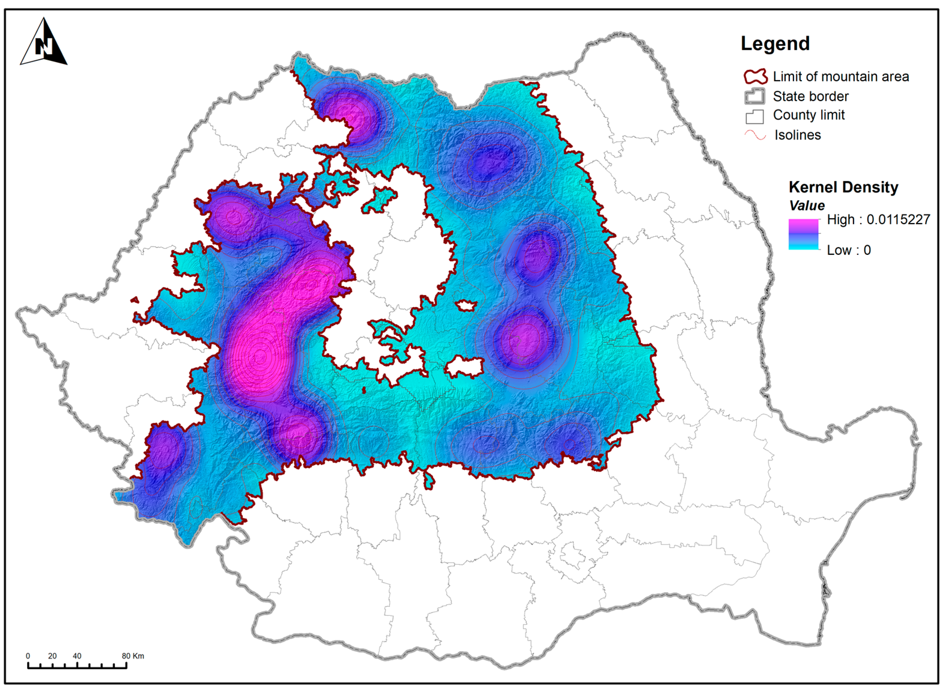
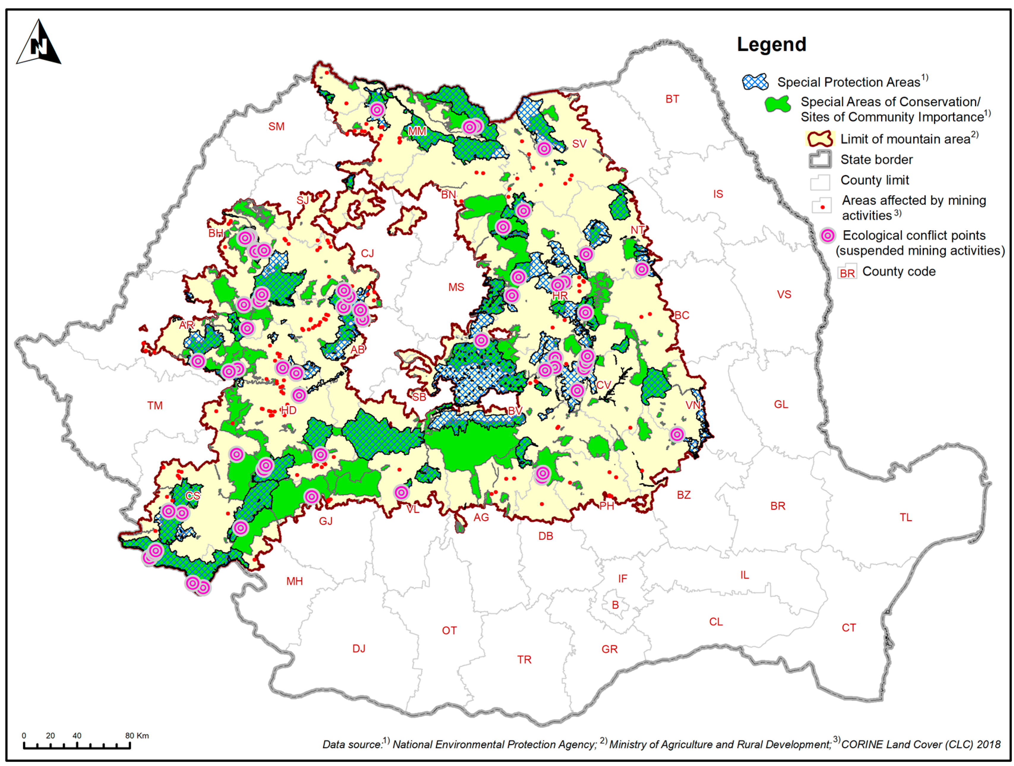
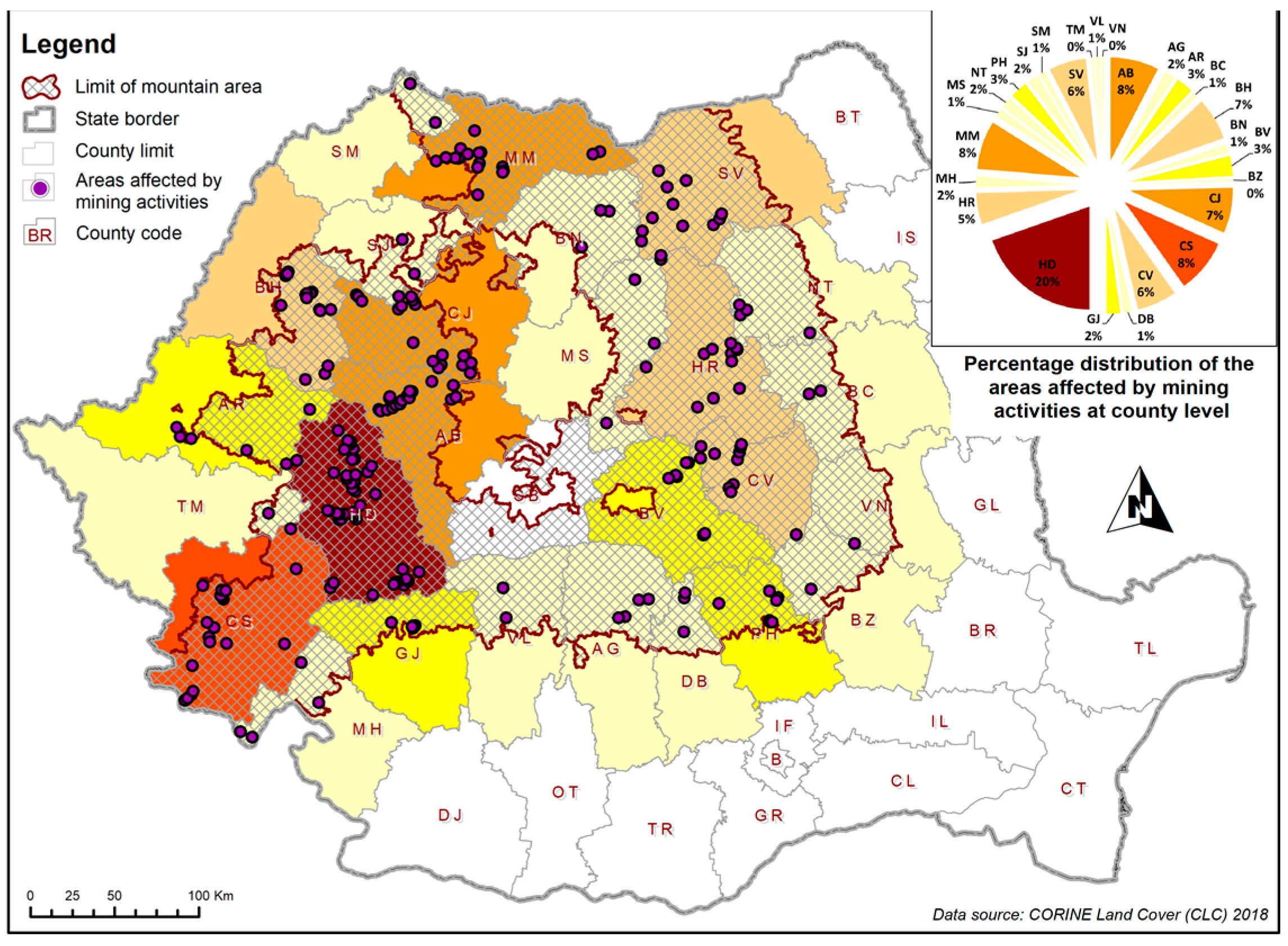
3.2. Spatial Distribution Characteristics

The mining sector in Romania’s mountainous regions has extensively transformed large land areas through excavation, tailings storage, underground mining, and construction activities. These interventions have increased entropy and disrupted the self-sustainability of mountain systems, leading to significant land being repurposed for agriculture, forestry, or other uses, thus necessitating urgent post-exploitation eco-rehabilitation. In 1989, mining was a way of life for 10% of the active population [72]. However, since 1999, the Mine Closure and Ecological Mining Programme (H.G. no. 418/1999 and H.G. no. 1158/2004) has overseen the closure of over 550 mining operations and about 30 preparation plants, leaving only the copper deposits at Roșia Poieni operational. The cessation of mining activities has left long-term demographic impacts, such as displacement of settlements, increased community vulnerability, altered population dynamics [73], and health issues for residents. The destructive nature of mining—discovery, transport, extraction, and waste storage—has led to persistent negative effects on mountain habitats and local fauna, affecting ecosystems with rare species [74,75,76,77,78]. The lack of preventive measures during waste processing and storage due to insufficient legislative frameworks has resulted in significant health and biodiversity impacts at many closed sites [79], highlighting the need for clear remediation methodologies for contaminated land and polluted groundwater.
Mining activities have polluted soil and groundwater with various contaminants, including cyanides, heavy metals, sulfate ions, hydrocarbons, and oxides, damaging aquatic biosystems up to 30 km from industrial perimeters. According to the National Strategy and National Action Plan for the Management of Contaminated Sites, “heavy metal contamination can only be remedied after assessing the acidification potential of deposited rocks” [80]. Romania has 1183 contaminated or potentially contaminated sites [81]. The negative impact of mining on mountain environmental systems is influenced by mining methods, duration, and the physical and geographical characteristics of the territory. While the extractive industry provides essential raw materials for economic development, it often conflicts with nature conservation regulations, especially EU directives on birds and habitats. An analysis of the mountain area identified 60 points of ecological conflict within Natura 2000 sites affected by mining works, which have not been ecologically protected (Figure 5). Of these, 31 are within Special Areas of Conservation (SAC)/Sites of Community Importance (SCI), and 29 are within Special Protection Areas (SPA) for birdlife.
Higher densities were reported in the northern Apuseni Mountains (ROSPA0115: Crișului Repede gorge, Valea Iadului), southern Banat Mountains (ROSCI0206: Porțile de Fier), and the central Eastern Carpathians (ROSPA0133: Călimani Mountains and ROSPA0082: Bodoc-Baraolt Mountains). The impact of extractive activities on mountain ecosystems includes not only extraction sites but also secondary works and facilities like clearing, earthworks, roads, conveyor belts, crushers, storage sites, residues, and plant platforms. The 2017 Report on the Inventory and Visual Inspection of Landfills and Settling Ponds in Romania identified 29 counties with industrial waste landfills (Figure 6), including Alba, Arad, Argeș, Bacău, Bihor, Bistrița-Năsăud, Brașov, Buzău, Caraș-Severin, Cluj, Constanța, Covasna, Dâmbovița, Dolj, Galați, Gorj, Harghita, Hunedoara, Maramureș, Mehedinți, Mureș, Neamț, Prahova, Sălaj, Satu Mare, Suceava, Timiș, Tulcea, and Vâlcea.
Of these, 25 counties are in the mountain area, while Sibiu and Vrancea counties have no industrial landfills [82] (Figure 7).
There were 1030 inventoried tailings pits in the mountain counties, with 994 being mining sites. Suceava County had the highest number (224), followed by Maramureș (180). Additionally, 141 ponds were near protected natural areas, and 35 tailings ponds were unstable. Seventeen mountain counties had settling ponds, totaling 108, with 31 near protected areas and 15 operational [83].
The mining of non-ferrous ores, especially gold and silver, in the Apuseni Mountains has spanned over two millennia, with near-continuous activity since pre-Roman times. This long history has left several industrial-extractive areas, necessitating measures to reintegrate them into productive ecological and economic circuits per current legislation (Figure 8). Kernel density analysis identified two primary mining hotspots: one in the southern and central-eastern Apuseni Mountains and a secondary hotspot in the north-western Pădurea Craiului Mountains (Figure 9).
The investigated territory shows an altitudinal distribution of 49 mining sites, ranging from 202 m (TAU Zam) to 1347 m (TAU Poieni). Most sites (23%) are found at 600–700 m, while the least (8%) are at 1000–1347 m. Thus, altitude does not impose restrictive conditions for ecological reconstruction. Slope, talus, and watershed gradients are influenced by stripping processes, structural-petrographic typology, relief evolution, and mining dynamics. These factors, combined with declivity, horizontal fragmentation, relief amplitude, slope exposure, climatic conditions, and anthropogenic intervention, condition risk factors in mining-affected mountain areas. Morphometric analysis reveals the distribution of mining sites by slope: 12% at 0–2°, 6% at 2.01–5°, 16% at 5.01–15°, 35% at 15.01–35°, 21% at 35.01–55°, and 10% at 55.01–64.72° (maximum at Poieni TAU). Most sites (56%) are on steep slopes, indicating high susceptibility to landslides, mudflows, and other stripping processes, posing challenges for ecological reconstruction. Slope exposure influences solar insolation, affecting soil moisture, vegetation quality, and morphodynamic processes. Only 8% of mining sites are on flat surfaces, while 42% are on sunny slopes (SW and W), favourable for vegetation regeneration. Shaded slopes (N, NE) house 41% of sites, more vulnerable to landslides and solifluction due to runoff during transitional periods.

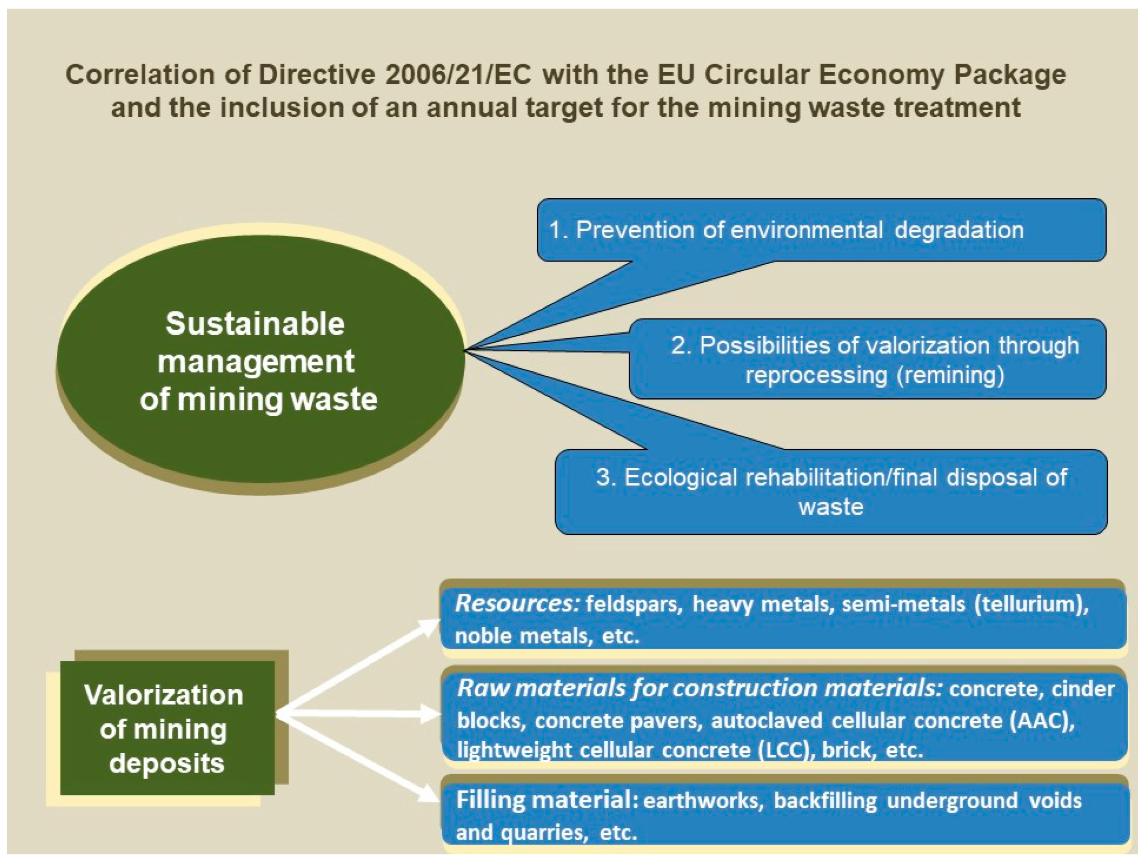
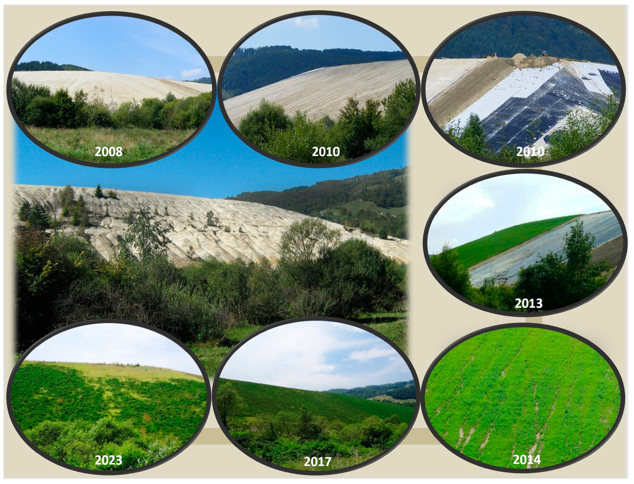
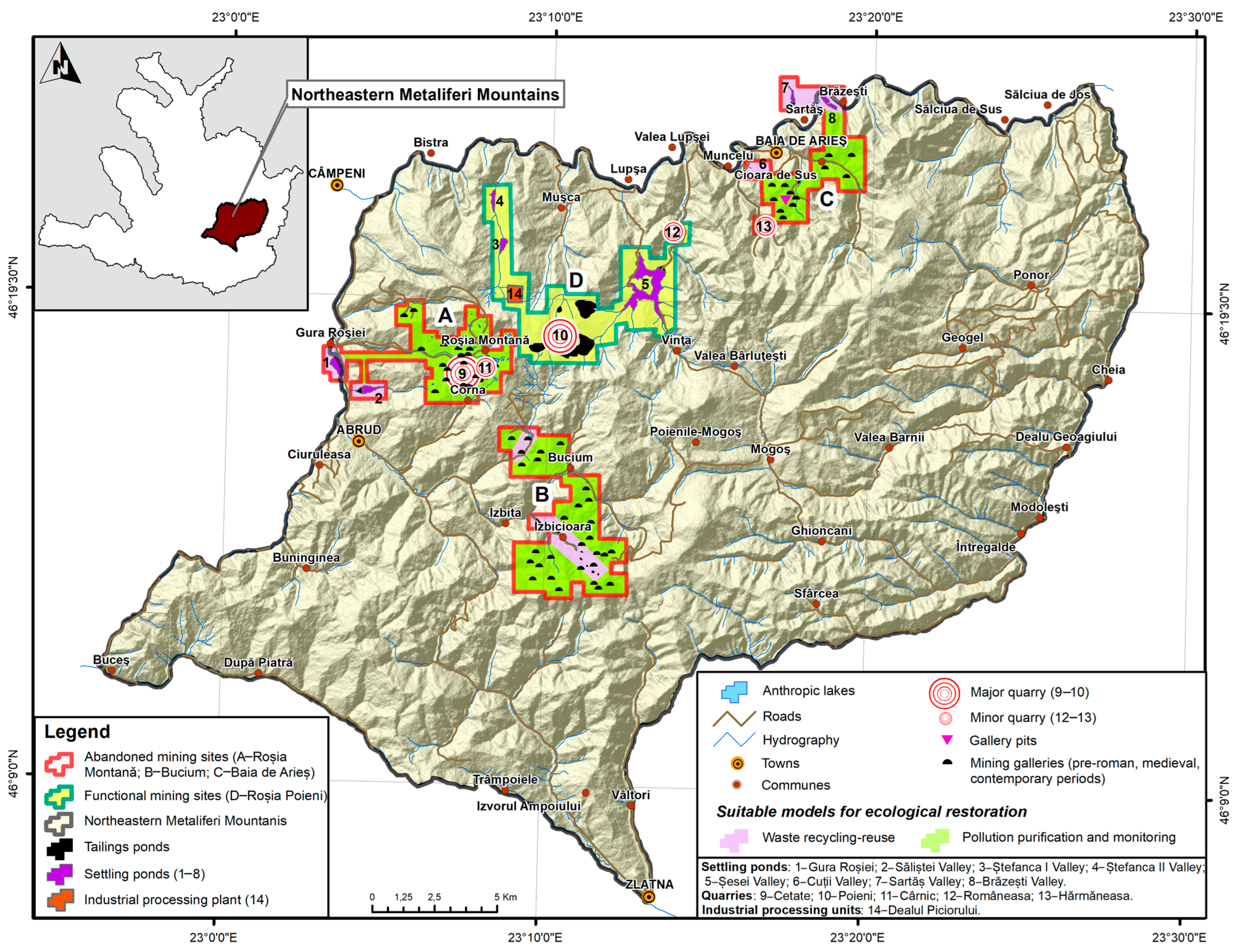
3.3. Reconstruction Mode

Two types of reconstruction technologies are suitable for the abandoned mining sites in the Apuseni Mountains: pollution purification and monitoring, and waste recycling–reuse. Initial stages involve mine redevelopment to regenerate soil fertility and plant cultivation or constructive purposes, followed by biological redevelopment for environmental recovery. The stages of landscaping mining sites depend on the final destination of tailings ponds. Environmental rehabilitation aims for land to function as self-maintaining ecosystems. Recycling–reuse technologies enable re-mining to recover precious metals or minerals, reducing tailings in mountain areas (Figure 10). Remediation costs should align with sustainable territorial development, requiring creative policy and fiscal solutions. The National Strategy and Action Plan aimed to address contaminated sites by 2020, continuing until 2050. Redeveloping mining-affected areas is part of integrated development strategies, focusing on post-mining reconstruction, greening, and sustainable redevelopment to restore economic potential (Figure 11). Reuse options for abandoned sites in the Apuseni Mountains include agricultural areas, fisheries, forests, recreational areas, adventure parks, sports fields, mining museums, architectural-mining reserves, geological parks, waste dumps, industrial parks, tourist mine galleries, photovoltaic parks, and reserve habitats [84,85].
The most frequent deficiencies in ecological reconstruction and rehabilitation of abandoned mining sites include inadequate re-profiling of steep slopes, use of simple waterproofing membranes without honeycomb structures, and economic greening methods with minimal vegetation. Issues also involve thin soil layers (15 cm), lack of integrated monitoring, and absence of a comprehensive vision for long-term ecological, social, economic, and cultural impacts. Restoration involves reintroducing degraded lands into the economic circuit through soil decontamination, slope stabilization with geo-synthetic materials, and ensuring vegetation regeneration [86]. Contaminated underground water requires pumping and purification. Numerous degraded and polluted surfaces in the Apuseni Mountains offer diverse conditions for sustainable reconstruction and resilient reintegration. Connecting these considerations, mining in the Apuseni Mountains has heavily impacted the environment due to the richness in non-ferrous ores (gold, silver, copper, zinc, lead), leaving a valuable cultural heritage. Roşia Montană, the oldest mining town in Romania, documented in 131 AD, is a significant archaeological site in Europe. Recently added to the UNESCO World Heritage List, this site highlights tourism’s potential as a future development engine. Restoration must balance the economic use of degraded lands with cultural preservation and sustainable practices, integrating ecological, social, and economic aspects to create resilient, functional spaces for future use [84,85].
The Northeastern Metaliferi Mountains, a regional subunit of the Apuseni Mountains, include the mining area with the most extensive territory affected by mining and the oldest and most diversified system of industrial-mining exploitation in the entire mountainous region of Romania. It covers a total area of 727 km2, of which abandoned mining sites account for over 10%, and the environmental and socio-economic impact is considerable. Our research has highlighted the existence of three abandoned mining sites, namely Roșia Montană, Bucium, and Baia de Arieș. Alongside these inactive sites, there is one of the largest operational mining sites in Europe, namely the copper exploitation at Roșia Poieni. Micro-scale analysis has revealed that within the same site, there are sectors that require different types of ecological reconstruction. Thus, in some sectors, interventions are needed for soil and water decontamination, while others are suitable for waste recycling and reuse operations (Figure 12). For example, in the case of Roșia Montană mining site, which spatially integrates exploitation quarries, tailings ponds, old networks of multi-level galleries, branched voids with an archaic appearance, primitive exploitation grottos, waste heaps, and industrial constructions, it is necessary to carefully apply ecological reconstruction works and spatial–functional reintegration of the territory. The techniques of ecological reconstruction and development works should primarily focus on protecting the traditional cultural landscape and preserving the architectural-mining vestiges of value to humanity, in accordance with the World Heritage Convention. Interventions should consider both the reconstruction of local ecosystems and the restoration of biodiversity, as well as the depollution of waters and decontamination of soils texturally modified by the gravitational accumulation of materials washed from the waste heap slopes or exfiltrations from old mining galleries and the body of the tailings ponds. The solutions implemented in this case involve the combined application of the two proposed models of ecological reconstruction. On one hand, recycling and reusing the mining waste stored in the Gura Roșiei and Săliștei Valley tailings ponds are necessary, while on the other hand, extensive interventions are needed for the decontamination of affected soil, as well as the depollution and restoration of water drainage within the perimeter of the abandoned mining exploitations. Moreover, the choice of appropriate implementation of ecological reconstruction techniques for mining sites must consider both the physico-mechanical characteristics of the excavation and storage structures, as well as the chemical composition of the waste, the types of ore deposits exploitation, and the industrial technologies used during processing. Additionally, the reconstruction process will include mandatory public consultation stages with the communities in the proximity of the mining sites, and sustainable land management and climate resilience will be ensured by identifying and applying the best nature-based solutions (NBSs). The forms of intervention must be based on rigorous analyses in terms of differentiated application in relation to local and regional territorial specificities, because they will have a series of implications in the social-economic plan as well (valuation of the local workforce by creating jobs, redefining activities in the context of the circular economy, the reconsideration of economic cycles based on the concept of eco-efficiency, and the development of alternative economic activities).

4. Discussion and Conclusions

4.1. Research Contributions

Ecological restoration aims to recover native ecosystems following disturbances, ranging from degradation to complete destruction [59,87]. A specialized sub-discipline focuses on post-mining landscape restoration, distinct due to significant disturbances. Recovery goals often favor creating novel or hybrid ecosystems, including native and non-native species, to ensure stability and functionality [30,88]. Governments now recognize the importance of post-mining rehabilitation aligned with ecological sustainability principles, enforcing legislation that includes financial guarantees, phased restoration, and non-polluting objectives [89,90,91,92,93,94]. Despite this, abandoned mine lands remain an issue, due to past insufficient legislation and financial instruments, seen in mining regions globally, including Romania. The rehabilitation of abandoned sites faces challenges such as undefined responsibilities, high costs, and lack of funds following the cessation of mining activities. Evaluation factors for such sites include age, environmental impact, public health concerns, social implications, government support, and community commitment to rehabilitation [95,96].
Our study highlights significant ecological and socio-economic challenges around abandoned mining sites in the Romanian Carpathians. Findings suggest adopting innovative, holistic, and sustainability-focused measures to transform these areas into resourceful environments. Romania’s pre-1989 industrial-mining activities were unsustainable, and post-communist socio-economic and political changes have led to neglect of former mining areas [97,98]. Addressing their marginalization requires solutions for environmental rehabilitation aimed at restoring long-term equilibrium in affected and neighboring areas. Authorities must attract funds to convert abandoned mining areas into innovative spaces, beyond mere populist measures [99].
The study adds to the literature on post-industrial landscape rehabilitation and sustainable regional development. The integrated model of territorial reconversion aligns with sustainable spatial planning principles [100], emphasizing a multidisciplinary approach for ecological reconstruction. The study advocates for active involvement from local, regional, and national authorities, focusing on funding to transform abandoned areas into innovative spaces [101]. Implementing new industrial eco-cycles and landscape rehabilitation is essential for reintegrating these territories into the economic circuit, creating jobs, and developing the local workforce. Our findings align with global studies on post-industrial regions, highlighting similar challenges and solutions. Examples from the UK, Germany, Australia, and the USA demonstrate the effectiveness of community-led projects and comprehensive policy frameworks [102,103]. However, this study’s focus on the specific geographical and socio-economic context of the Romanian Carpathians provides unique insights into the differentiated application of rehabilitation measures. It emphasizes the importance of local and regional territorial specificities in designing and implementing sustainable development strategies [104]. Data for characterizing abandoned mining sites were gathered based on relevant thematic elements, sampling, and regional validation. The methodological system used highlights specific research methods that provide objective results, forming an optimal framework for action. The investigation combined geographical research methods and interdisciplinary resources, linked to current territorial realities.

4.2. Practical Implications

Developing an integrated model of territorial reconversion, tailored to the community’s social, economic, cultural, and environmental needs [105], and identifying alternative solutions to leverage endogenous potential, is crucial for sustainable spatial planning in mining-affected mountain areas. This research evaluated risk factors for mining sites, including anthropogenic geomorphostructures, factors amplifying negative effects, stability of geotechnical arrangements, potential destructive geomorphological processes, and optimal reintegration solutions for degraded post-exploitation surfaces.
Our analysis confirms that environmental rebalancing of abandoned mining sites in mountain areas is feasible, ensuring optimal functionality and sustainability. Mitigating risks associated with tailings ponds, settling ponds, underground galleries, and quarries (e.g., material detachments, accidental acidic water discharges, toxic substance pollution, landscape, and biodiversity degradation) from long-term mining in the Apuseni Mountains requires tailored ecological rehabilitation and reconstruction measures. A holistic approach to rehabilitation involves integrated monitoring of territorial components, relationships, vulnerable structures within mining sites, and positional risks. Sustainable management of post-exploitation eco-rehabilitation must extend to all mountain areas with industrial extractive activities, aiming for long-term ecological reconstruction and reintegration into the economic circuit.
To succeed, rehabilitation efforts need acceptance from all stakeholders (territorial-administrative institutions, businesses, local community) and alignment with national and regional strategic objectives. Challenges include the uncertain legal status of lands designated for closure and greening works or modernization of mine water treatment stations. Recommendations for state institutions and mining specialists include revising legislation on mining waste deposits, clarifying land legal status to avoid compromising greening efforts, and reconsidering the valorization of mining cultural heritage for tourism and the circular economy. Implementing new industrial eco-cycles, landscape rehabilitation, and integrated reconstruction of abandoned sites and degraded areas is essential. Despite a 2017 national inventory of mining waste deposits, ongoing identification, expertise, monitoring, and good practice implementation, aligned with European legislative frameworks, are critical.

4.3. Limitations and Future Directions

In carrying out this study, some limitations have been noted, which will be discussed in this subsection. Specifically, errors associated with the data collection and processing stage of the datasets extracted from the CLC 2018 were identified, such as inaccuracies in the classification of certain land use categories. For instance, some settling ponds associated with the Baia de Arieș mining site were incorrectly classified by Romanian specialised authorities in the field as deciduous forests. In addition to this, the Groapa Ruginoasă-Valea Seacă protected area was also misclassified by these authorities as an “ore extraction area” and the Tărnicioara and Valea Straja settling ponds were inaccurately categorized as “waste pits”. To address these inaccuracies, alternative methods such as satellite/aerial imagery and field observations were applied for data validation.
Another limitation is the absence of a national open access database on mining activity in Romania, which would include detailed information on the location, type, period of activity, current status, and ownership of abandoned sites. Despite these limitations, the research results are robust, based on relevant information and complex spatial and quantitative data structures with high methodological precision and accuracy. Future research should aim to develop a comprehensive national database on mining activities, enhancing the accuracy of ecological and socio-economic assessments and supporting better-informed decision-making [101]. Moreover, longitudinal studies involving community participation are essential to understand the long-term impacts of rehabilitation measures and refine strategies. Exploring eco-tourism and the circular economy could also provide sustainable economic alternatives [103]. In conclusion, while this study provides a foundational framework for the rehabilitation of abandoned mining sites in the Romanian Carpathians, addressing these limitations and pursuing further research is crucial for achieving long-term sustainability and regional development. We believe that the outcomes of our study could be further developed by gaining insights through interviews and surveys with the people living in mountain mining areas.

Author Contributions

Conceptualization, V.G. and R.C.; methodology, V.G.; software, V.G.; validation, V.G., E.-A.N. and R.C.; formal analysis, V.G.; investigation, R.C.; resources, E.-A.N.; data curation, E.-A.N.; writing—original draft preparation, V.G.; writing—review and editing, E.-A.N. and R.C; visualization, E.-A.N.; supervision, R.C.; project administration, R.C.; funding acquisition, R.C. All authors have read and agreed to the published version of the manuscript.

Funding

This research received no external funding.

Data Availability Statement

Data of this study could be provided by request from Viorel Gligor.

Conflicts of Interest

The authors declare no conflicts of interest.

References

  1. Young, R.E.; Gann, G.D.; Walder, B.; Liu, J.; Cui, W.; Newton, V.; Nelson, C.R.; Tashe, N.; Jasper, D.; Silveira, F.A.; et al. International principles and standards for the ecological restoration and recovery of mine sites. Restor. Ecol. 2022, 30, e13771. [Google Scholar] [CrossRef]
  2. Salomons, W. Environmental impact of metals derived from mining activities: Processes, predictions, prevention. J. Geochem. Explor. 1995, 52, 5–23. [Google Scholar] [CrossRef]
  3. Luís, A.T.; Teixeira, P.; Almeida, S.F.P.; Matos, J.X.; da Silva, E.F. Environmental impact of mining activities in the Lousal area (Portugal): Chemical and diatom characterization of metal-contaminated stream sediments and surface water of Corona stream. Sci. Total Environ. 2011, 409, 4312–4325. [Google Scholar] [CrossRef]
  4. Zobrist, J.; Sima, M.; Dogaru, D.; Senila, M.; Yang, H.; Popescu, C.; Roman, C.; Bela, A.; Frei, L.; Dold, B.; et al. Environmental and socioeconomic assessment of impacts by mining activities—A case study in the Certej River catchment, Western Carpathians, Romania. Environ. Sci. Pollut. Res. 2009, 16, 14–26. [Google Scholar] [CrossRef]
  5. Păcurar, B.N.; Nicula, S.A.; Strinu, O.; Surd, V. Indexing the Innovative Capability of Romanian NUTS 3 Subdivisions (Counties). J. Settl. Spat. Plan. 2016, 7, 45–49. [Google Scholar]
  6. Fleming, D.A.; Measham, T.G. Local job multipliers of mining. Resour. Policy 2014, 41, 15–19. [Google Scholar] [CrossRef]
  7. Knobblock, E.A.; Pettersson, Ö. Restructuring and risk-reduction in mining: Employment implications for northern Sweden. Fenn. Int. J. Geogr. 2010, 188, 61–75. [Google Scholar]
  8. Farjana, S.H.; Huda, N.; Parvez Mahmud, M.A.; Saidur, R. A review on the impact of mining and mineral processing industries through life cycle assessment. J. Clean. Prod. 2019, 231, 1200–1217. [Google Scholar] [CrossRef]
  9. Farahani, H.; Bayazidi, S. Modeling the assessment of socio-economic and environmental impacts of sand mining on local communities: A case study of Villages Tatao River Bank in North-western part of Iran. Resour. Pol. 2018, 55, 87–95. [Google Scholar] [CrossRef]
  10. Haddaway, N.R.; Cooke, S.J.; Lesser, P.; Macura, B.; Nilsson, A.E.; Taylor, J.J.; Raito, K. Evidence of the impacts of metal mining and the effectiveness of mining mitigation measures on social–ecological systems in Arctic and boreal regions: A systematic map protocol. Environ. Evid. 2019, 8, 1–11. [Google Scholar] [CrossRef]
  11. Hilson, G. An overview of land use conflicts in mining communities. Land Use Policy 2002, 19, 65–73. [Google Scholar] [CrossRef]
  12. Nicula, A.S.; Stoica, M.S.; Bîrsănuc, E.M.; Man, T.C. Why Do Romanians Take to the Streets? A Spatial Analysis of Romania’s 2016–2017 Protests. Rom. J. Political Sci. 2019, 19, 201–222. [Google Scholar]
  13. Botezan, C.; Constantin, V.; Meltzer, M.; Radovici, A.; Pop, A.; Alexandrescu, F.; Stefanescu, L. Is there sustainable development after mining? a case study of three mining areas in the Apuseni region (Romania). Sustainability 2020, 12, 9791. [Google Scholar] [CrossRef]
  14. Svobodova, K.; Sklenicka, P.; Molnarova, K.; Salek, M. Visual preferences for physical attributes of mining and post-mining landscapes with respect to the sociodemographic characteristics of respondents. Ecol. Eng. 2012, 43, 34–44. [Google Scholar] [CrossRef]
  15. Sonter, L.J.; Moran, C.J.; Barrett, D.J.; Soares-Filho, B.S. Processes of land use change in mining regions. J. Clean. Prod. 2014, 84, 494–501. [Google Scholar] [CrossRef]
  16. Swenson, J.J.; Carter, C.E.; Domec, J.-C.; Delgado, C.I. Gold mining in the Peruvian Amazon: Global prices, deforestation, and mercury imports. PLoS ONE 2011, 6, 18875. [Google Scholar] [CrossRef] [PubMed]
  17. Warhate, S.; Yenkie, M.; Chaudhari, M.; Pokale, W. Impacts of mining activities on water and soil. J. Environ. Sci. Eng. 2006, 48, 81–90. [Google Scholar] [PubMed]
  18. Mchaina, D. Environmental planning considerations for the decommissioning, closure and reclamation of a mine site. Int. J. Surf. Min. Reclam. Environ. 2001, 15, 163–176. [Google Scholar] [CrossRef]
  19. Navarro, M.; Pérez-Sirvent, C.; Martínez-Sánchez, M.; Vidal, J.; Tovar, P.; Bech, J. Abandoned mine sites as a source of contamination by heavy metals: A case study in a semi-arid zone. J. Geochem. Explor. 2008, 96, 183–193. [Google Scholar] [CrossRef]
  20. Amirshenava, S.; Osanloo, M. A hybrid semi-quantitative approach for impact assessment of mining activities on sustainable development indexes. J. Clean. Prod. 2019, 218, 823–834. [Google Scholar] [CrossRef]
  21. Jain, R.; Cui, Z.; Domen, J. Environmental impacts of mining. In Environmental Impact of Mining and Mineral Processing: Management, Monitoring, and Auditing Strategies; Jain, R., Cui, Z., Domen, J., Eds.; Elsevier: Amsterdam, The Netherlands, 2016; pp. 53–157. [Google Scholar]
  22. Tost, M.; Hitch, M.; Chandurkar, V.; Moser, P.; Feiel, S. The state of environmental sustainability considerations in mining. J. Clean. Prod. 2018, 182, 969–977. [Google Scholar] [CrossRef]
  23. Andronache, I.; Marin, M.; Fischer, R.; Ahammer, H.; Radulovic, M.; Ciobotaru, A.M.; Jelinek, H.F.; Di Ieva, A.; Pintilii, R.D.; Drăghici, C.C.; et al. Dynamics of Forest Fragmentation and Connectivity Using Particle and Fractal Analysis. Sci. Rep. 2019, 9, 12228. [Google Scholar] [CrossRef] [PubMed]
  24. Mert, Y. Contribution to sustainable development: Re-development of post-mining brownfields. J. Clean. Prod. 2019, 240, 118–212. [Google Scholar] [CrossRef]
  25. Asr, E.T.; Kakaie, R.; Ataeia, M.; Mohammadi, M.R.T. A review of studies on sustainable development in mining life cycle. J. Clean. Prod. 2019, 229, 213–231. [Google Scholar] [CrossRef]
  26. Ilovan, O.R.; Dulamă, M.E.; Boțan, C.N.; Havadi-Nagy, K.X.; Horvath, C.; Nițoaia, A.; Nicula, S.; Rus, G.M. Environmental education and education for sustainable development in Romania. Teachers’ perceptions and recommendations. JEPE 2018, 19, 350–356. [Google Scholar] [CrossRef]
  27. Cao, X. Regulating mine land reclamation in developing countries: The case of China. Land Use Policy 2007, 24, 472–483. [Google Scholar] [CrossRef]
  28. Rooney, R.C.; Bayley, S.E. Development and testing of an index of biotic integrity based on submersed and floating vegetation and its application to assess reclamation wetlands in Alberta’s oil sands area, Canada. Environ. Monit. Assess. 2011, 184, 749–761. [Google Scholar] [CrossRef]
  29. Zipper, C.E.; Burger, J.; Barton, C.; Skousen, J. Rebuilding soils on mined land for native forests in Appalachia, USA. Soil Sci. Soc. Am. J. 2013, 77, 337–349. [Google Scholar] [CrossRef]
  30. McKenna, P.B.; Lechner, A.M.; Phinn, S.; Erskine, P.D. Remote sensing of mine site rehabilitation for ecological outcomes: A global systematic review. Remote Sens. 2020, 12, 3535. [Google Scholar] [CrossRef]
  31. Dragastan, O.; Damian, R.; Csiki, Z.; Lazăr, I.; Marinescu, M. Review of the bauxite-bearing formations in the Northern Apuseni Mts. Area (Romania) and some aspects of the environmental impact of the mining activities. Carpathian J. Earth Environ. Sci. 2009, 4, 5–24. [Google Scholar]
  32. Sinnett, D.E.; Sardo, A.M. Former metal mining landscapes in England and Wales: Five perspectives from local residents. Landsc. Urban Plan. 2020, 193, 103685. [Google Scholar] [CrossRef]
  33. Mitchell, C.J.; O’Neill, K. The Sherrif Creek Wildlife Sanctuary: Further evidence of mine-site repurposing and economic transition in northern Ontario. Extr. Ind. Soc. 2017, 4, 24–35. [Google Scholar]
  34. Almăşan, B. Exploatarea Zăcămintelor Minerale din România; Editura Tehnică: Bucharest, Romania, 1984; Volume I and II. [Google Scholar]
  35. Lăcătuşu, R.; Răuţă, C.; Neda, C.; Medrea, N. Efectul poluării cu metale grele asupra sistemului sol-plantă-animal din unele zone ale României. Mediu. Înconjurător 1991, 2, 1–2. [Google Scholar]
  36. Tălângă, C.R. Implicaţii ale exploatărilor miniere de la Roşia Poieni asupra demografiei regionale. Terra. Revistă a Societăţii Române de Geografie 1991, 2–4, 37–39. [Google Scholar]
  37. Iacob, G. Activităţile miniere din estul Munţilor Mureşului şi implicaţiile acestora asupra mediului. Stud. Cercet. Geogr. 1995, 42, 73–79. [Google Scholar]
  38. Duma, S. Studiu Geologic al Exploatărilor Miniere din Zona Sudică a Munților Apuseni, Munții Poiana Ruscă și Munții Sebeșului; Editura Dacia: Cluj-Napoca, Romania, 1998. [Google Scholar]
  39. Duma, S. Geoecologie; Editura Dacia: Cluj-Napoca, Romania, 2000. [Google Scholar]
  40. Muntean, O.L.; Rus, R.; Surdeanu, V. Relieful antropic din regiunea minieră Abrud-Roşia Montană. Studia Univ. “Babeş-Bolyai”, Geographia 1998, 2, 32–38. [Google Scholar]
  41. Bătinaş, R. Degradarea calităţii apei râului Arieş, ca urmare a deversărilor de ape uzate industriale de la exploatările miniere Roşia Montană, Abrud şi Baia de Arieş. Geographica Timisensis 1999, 8–9, 123–134. [Google Scholar]
  42. Csagoly, P. Scurgerea de Cianură de la Baia Mare, România, Cauze, Desfășurare, Urmări; Centrul Regional de Protecția Mediului pentru Europa Centrală și de Est: București, Romania, 2000. [Google Scholar]
  43. Damian, G.; Oros, V. Reabilitarea Ecologică şi Managementul Siturilor Degradate din Industria Minieră; Editura Universităţii de Nord: Baia Mare, Romania, 2000. [Google Scholar]
  44. Andraş, I. Quick assessment method for the slope stability factor of waste deposit dams. In Proceedings of the 29th International Symposium on Computer Applications in the Mineral Industries, Beijing, China, 25–27 April 2001; pp. 709–710. [Google Scholar]
  45. Dumitru, F.; Băican, G. Impactul Industriei Miniere Asupra Mediului; Editura Infomin: Deva, Romania, 2001. [Google Scholar]
  46. Popescu, G.; Dumitrescu, L.; Buia, G. Relația dintre zăcămintele metalifere și poluarea în Munții Apuseni. In Proceedings of the 4th World Mining Environment Congress, Bucharest, Romania, 11–12 May 2001. [Google Scholar]
  47. Kozak, J.; Ostapowicz, K.; Bytnerowicz, A.; Wyżga, B. The Carpathian Mountains: Challenges for the Central and Eastern European Landmark. In The Carpathians: Integrating Nature and Society Towards Sustainability; Kozak, J., Ostapowicz, K., Bytnerowicz, A., Wyżga, B., Eds.; Environmental Science and Engineering; Springer: Berlin/Heidelberg, Germany, 2013. [Google Scholar]
  48. Kholiavchuk, D.; Gurgiser, W.; Mayr, S. Carpathian Forests: Past and Recent Developments. Forests 2023, 15, 65. [Google Scholar] [CrossRef]
  49. Atanacković, N.; Dragišić, V.; Stojković, J.; Papić, P.; Živanović, V. Hydrochemical characteristics of mine waters from abandoned mining sites in Serbia and their impact on surface water quality. Environ. Sci. Pollut. Res. 2013, 20, 7615–7626. [Google Scholar] [CrossRef]
  50. Rapant, S.; Dietzová, Z.; Cicmanová, S. Environmental and health risk assessment in abandoned mining area, Zlata Idka, Slovakia. Environ. Geol. 2006, 51, 387–397. [Google Scholar] [CrossRef]
  51. Schuchová, K.; Lenart, J.; Miklín, J.; Horáček, M. Abandoned underground mines in Nízký Jeseník Upland (Czechia). J. Maps 2023, 19, 2175733. [Google Scholar] [CrossRef]
  52. Nistor, M.; Nicula, A.S.; Cervi, F.; Man, T.; Irimuș, I.A.; Surdu, I. Groundwater vulnerability GIS models in the carpathian mountains under climate and land cover changes. Appl. Ecol. Environ. Res. 2018, 16, 5095–5116. [Google Scholar] [CrossRef]
  53. Rodolaki, C.; Barakos, G.; Hitch, M. The role of intercultural differences and challenges faced in negotiating active mine sites’ rehabilitation objectives from Africa to Europe. Extr. Ind. Soc. 2023, 16, 101362. [Google Scholar]
  54. Alonzo, D.; Tabelin, C.B.; Dalona, I.M.; Beltran, A.; Orbecido, A.; Villacorte-Tabelin, M.; Resabal, V.J.; Promentilla, M.A.; Brito-Parada, P.; Plancherel, Y.; et al. Bio+ Mine project: Empowering the community to develop a site-specific system for the rehabilitation of a legacy mine. Int. J. Qual. Methods 2023, 22, 16094069231176340. [Google Scholar] [CrossRef]
  55. Salom, A.T.; Kivinen, S. Closed and abandoned mines in Namibia: A critical review of environmental impacts and constraints to rehabilitation. S. Afr. Geogr. J. 2020, 102, 389–405. [Google Scholar] [CrossRef]
  56. Mhlongo, S.E.; Amponsah-Dacosta, F.; Mphephu, N.F. Rehabilitation prioritization of abandoned mines and its application to Nyala Magnesite Mine. J. Afr. Earth Sci. 2013, 88, 53–61. [Google Scholar] [CrossRef]
  57. Cornelissen, H.; Watson, I.; Adam, E.; Malefetse, T. Challenges and strategies of abandoned mine rehabilitation in South Africa: The case of asbestos mine rehabilitation. J. Geochem. Explor. 2019, 205, 106354. [Google Scholar] [CrossRef]
  58. Fadda, S.; Fiori, M.; Matzuzzi, C. Developing rehabilitation design for the abandoned mine excavations in Central Sardinia, Italy. Int. J. Min. Reclam. Environ. 2010, 24, 286–306. [Google Scholar] [CrossRef]
  59. Gann, G.D.; McDonald, T.; Walder, B.; Aronson, J.; Nelson, C.R.; Jonson, J.; Hallett, J.G.; Eisenberg, C.; Guariguata, M.R.; Liu, J.; et al. International principles and standards for the practice of ecological restoration. Second edition. Restor. Ecol. 2019, 27, S1–S46. [Google Scholar] [CrossRef]
  60. Ministry of Agriculture and Rural Development. Order no. 97/1332/2019. Available online: https://legislatie.just.ro/Public/DetaliiDocumentAfis/211979 (accessed on 3 June 2024).
  61. Nicula, A.S.; Stoica, M.S.; Ilovan, O.R. The Cultural-Historical and Political Spheres of Influence of Alba Iulia. Transylv. Rev. 2017, 26 (Suppl. S2), 299–315. [Google Scholar]
  62. Adorean, E.C.; Nofre, J.; Ilovan, O.R.; Gligor, V. Exploring nightlife in the university city of Cluj-Napoca (Romania): A mixed methods research study. Fennia 2020, 1–2, 180–195. [Google Scholar] [CrossRef]
  63. Zha, Y.; Gao, Y.; Ni, S. Use of normalized difference built-up index in automatically mapping urban areas from TM imagery. Int. J. Remote Sens. 2003, 24, 583–594. [Google Scholar] [CrossRef]
  64. European Union’s Circular Economy Package, Linked to Directive 2006/21/EC. Available online: https://eur-lex.europa.eu/LexUriServ/LexUriServ.do?uri=CONSLEG:2006L0021:20090807:EN:PDF (accessed on 8 April 2024).
  65. Bîrsănuc, E.M.; Cociș, E.A.; Gligor, V.; Man, T.C.; Nicula, A.S.; Stoica, M.S. Performing Democracy. An Analysis of Church-Based Electoral Capital in Romania. Transylv. Rev. 2020, 29, 291–309. [Google Scholar] [CrossRef]
  66. Nicula, A.-S.; Medveschi, I.; Avădănei, V.; Surdu, I.; Cociș, E.-A. Accessibility and Ecclesiastic Polarization of Monastic Settlements in the Romanian Carpathians. Case Study: Monastic Settlements in the Occidental Carpathians. In Proceedings of the 5th International Conference on Economic Scientific Research—Theoretical, Empirical and Practical Approaches (ESPERA), Bucharest, Romania, 10–11 October 2019. [Google Scholar]
  67. Vesalon, L.; Creţan, R. Mono-industrialism and the struggle for alternative development: The case of the Rosia Montana project. Tijdschr. Voor Econ. Soc. Geogr. 2013, 104, 539–555. [Google Scholar] [CrossRef]
  68. Nicula, A.S.; Boțan, C.N.; Gligor, V.; Cociș, E.A. Celebrating the Great Union through smart digital solutions: Lessons from Alba Iulia, Romania. J. Urban Hist. 2022, 48, 425–443. [Google Scholar] [CrossRef]
  69. Landsat Database. Available online: https://earthexplorer.usgs.gov (accessed on 5 April 2024).
  70. Nistor, M.M.; Nicula, A.S.; Dezsi, Ş.; Petrea, D.; Kamarajugedda, S.A.; Carebia, I.A. GIS-Based Kernel Analysis for Tourism Flow Mapping. J. Settl. Spat. Plan. 2020, 11, 137–145. [Google Scholar] [CrossRef]
  71. Nistor, M.M.; Mîndrescu, M.; Petrea, D.; Nicula, A.S.; Rai, P.K.; Benzaghta, M.A.; Dezsi, Ş.; Hognogi, G.; Porumb-Ghiurco, C.G. Climate change impact on crop evapotranspiration in Turkey during the 21st Century. Meteorol. Appl. 2019, 26, 442–453. [Google Scholar] [CrossRef]
  72. Mironovici, R.; Turdean, N. Considerations on manual mine clearance. Mine Mag. 2001, 10–11. [Google Scholar]
  73. Nistor, M.M.; Nicula, A.S. Application of GIS Technology for Tourism Flow Modelling in The United Kingdom. Geogr. Tech. 2021, 16, 1–12. [Google Scholar] [CrossRef]
  74. Cocan, D.; Udrescu, B.; Muntean, G.; Constantinescu, R.; Uiuiu, P.; Nicula, A.S.; Houssou, A.M.; Lațiu, C.; Mireșan, V. Fish species distribution and diversity indices from Iara river—Transylvania, Romania. Sci. Pap. Ser. D Anim. Sci. 2020, 63, 466–472. [Google Scholar]
  75. Laţiu, C.; Cocan, D.; Uiuiu, P.; Matei-Lațiu, M.C.; Ihuț, A.; Nicula, A.S.; Lațiu, I.; Constantinescu, R.; Mireşan, V. The influence of damming on the distribution of brown trout salmo trutta linnaeus, 1758 and european grayling Thymallus thymallus Linnaeus, 1758 (pisces: Salmonidae) from Someșul Cald river. Sci. Pap. Ser. D Anim. Sci. 2020, 63, 528–538. [Google Scholar]
  76. Lațiu, C.; Papuc, T.; Muntean, G.; Uiuiu, P.; Constantinescu, R.; Matei-Lațiu, M.C.; Nicula, A.S.; Craioveanu, C.; Mireșan, V.; Cocan, D. Fish Species Diversity. From Someșul Cald River: 50 Years After Cascade Dam Constructions. Front. Environ. Sci. 2022, 10, 918745. [Google Scholar] [CrossRef]
  77. Lațiu, C.; Constantinescu, R.; Mireșan, V.; Nicula, A.S.; Dumitraș, D.E.; Papuc, T.; Uiuiu, P.; Cocan, D. Length-weight relationships and fulton condition factor (K) of freshwater fish species from the Ruscova river, spawning ground of Danube salmon Hucho Hucho, Linnaeus, 1758 (Pisces: Salmonidae). Sci. Pap. Ser. D Anim. Sci. 2022, 65, 607–611. [Google Scholar]
  78. Lațiu, C.; Moraru, M.F.; Uiuiu, P.; Constantinescu, R.; Nicula, A.S.; Papuc, T.; Mireșan, V.; Cocan, D. Current status and length–weight relation of the European mudminnow, Umbra krameri (Actinopterygii: Esociformes: Umbridae), from Jieț River, Dolj County, southwestern Romania. Acta Ichthyol. Piscat. 2023, 53, 19–26. [Google Scholar] [CrossRef]
  79. Mihai, A.L.; Mulțescu, M.; Negoiță, M.; Horneț, G.A.; Surdu, I.; Nicula, A.S. Nutritional characterization of some Romanian mountain products. Ann. Univ. Dunarea De Jos Galati. Fascicle VI-Food Technol. 2022, 46, 104–124. [Google Scholar] [CrossRef]
  80. Ministry of the Environment. National Strategy and National Action Plan for the Management of Contaminated Sites in Romania. 2015. Available online: http://www.mmediu.ro/beta/wp-content/uploads/2014/02/2014-02-13_STRATEGIA.pdf (accessed on 5 April 2024).
  81. National Strategy and National Action Plan for the Management of Contaminated Sites in Romania. 2015. Available online: https://www.fao.org/faolex/results/details/en/c/LEX-FAOC197164/ (accessed on 5 April 2024).
  82. Report on the Inventory and Visual Inspection of Landfills and Settling Ponds in Romania. The Interministerial Commission for the National Inventory of Tailings Dumps and Settling Ponds—Report on the stage of September 12, 2017, Technical Secretariat, Dir. Res. Min. 2017. Available online: http://www.economie.gov.ro/images/resurse-minerale/Raport%20Halde%20Iazuri%2012%20sept%202017.pdf (accessed on 8 April 2024).
  83. Ministry of Economy. Mining Strategy of Romania 2017–2035. Interim Report 2. Environmental Report—First Version. 2017. Available online: http://www.economie.gov.ro/images/resurse-minerale/3%20Raport%20intermediar%20de%20mediu%20Strategia%20miniera%202017-2035%20prima%20versiune%2C%20dec%202017.pdf (accessed on 7 April 2024).
  84. Cociș, E.A.; Soporan, V.F.; Ilea, P.; Imre-Lucaci, F.; Soporan, B.M.; Bere, P.; Nemeș, O. Characterisation of generated ash from hazardous waste incineration. Stud. Univ. Babes-Bolyai Chem. 2012, 57, 147–156. [Google Scholar]
  85. Soporan, M.; Soporan, V.; Cociș, E.-A.; Bătrînescu, G.; Nemeș, O. Gas Analysis of Municipal Landfill Emissions. Stud. Univ. Babeș-Bolyai Chem. 2012, 57, 23–30. [Google Scholar]
  86. Bota, V.B.; Neamțu, A.A.; Olah, N.K.; Chișe, E.; Burtescu, R.F.; Pripon Furtuna, F.R.; Nicula, A.S.; Neamțu, C.; Maghiar, A.M.; Ivănescu, L.C.; et al. Comparative analysis of the anatomy, phenolic profile, and antioxidant capacity of Tussilago farfara L. vegetative organs. Plants 2022, 11, 1663. [Google Scholar] [CrossRef]
  87. Hobbs, R.J.; Norton, D.A. Towards a conceptual framework for Restoration Ecology. Restor. Ecol. 1996, 4, 93–110. [Google Scholar] [CrossRef]
  88. Doley, D.; Audet, P. Adopting novel ecosystems as suitable rehabilitation alternatives for former mine sites. Ecol. Process. 2013, 2, 1–11. [Google Scholar] [CrossRef]
  89. The European Parliament. Directive 2006/21/EC of the European Parliament and of the Council of 15 March 2006 on the Management of Waste from Extractive Industries and Amending Directive2004/35/EC; The European Parliament: Strasbourg, France, 2006; Available online: https://eur-lex.europa.eu/eli/dir/2006/21/2009-08-07 (accessed on 4 April 2024).
  90. Republic of South Africa. Mineral and Petroleum Resources Development Act; South African Government: Cape Town, South Africa, 2002; p. 122. Available online: https://www.gov.za/documents/ (accessed on 4 April 2024).
  91. People’s Republic of China. Mineral Resources Law; Ministry of Commerce: Beijing, China, 2009. Available online: http://www.china.org.cn/environment/2007-08/20/content_1034342.htm (accessed on 4 April 2024).
  92. Province of Alberta. Environmental Protection and Enhancement Act. Revised Statutes of Alberta 2000 Chapter E-12; Province of Alberta: Edmonton, AB, Canada, 2020; p. 168. Available online: https://www.qp.alberta.ca/ (accessed on 4 April 2024).
  93. Western Australia Government. Mining Rehabilitation Fund Act 2012; Department of Mines, Industry Regulation and Safety: Perth, Australia, 2014; p. 31. Available online: www.legislation.wa.gov.au (accessed on 4 April 2024).
  94. Queensland Government. Mineral and Energy Resources (Financial Provisioning) Bill 2018; Department of Environment and Science: Brisbane, Australia, 2018; p. 204. Available online: https://www.parliament.qld.gov.au/Documents/TableOce/TabledPapers/2018/5618T173.pdf (accessed on 4 April 2024).
  95. Mavrommatis, E.; Menegaki, M. Setting rehabilitation priorities for abandoned mines of similar characteristics according to their visual impact: The case of Milos Island, Greece. J. Sustain. Min. 2017, 16, 104–113. [Google Scholar] [CrossRef]
  96. Mhlongo, S.E.; Amponsah-Dacosta, F. A review of problems and solutions of abandoned mines in South Africa. Int. J. Min. Reclam. Environ. 2016, 30, e279–e294. [Google Scholar] [CrossRef]
  97. Ianoș, I.; Mihai, B.; Marin, M. Environmental and Socio-Economic Challenges in Post-Mining Regions of the Romanian Carpathians. Environ. Res. Lett. 2023, 15, 045001. [Google Scholar]
  98. Dragan, A.; Popa, N. Social economy in post-communist Romania: What kind of volunteering for what type of NGOs? J. Balk. Near East. Stud. 2017, 19, 330–350. [Google Scholar] [CrossRef]
  99. Doiciar, C.; Creţan, R. Pandemic populism: COVID-19 and the rise of the nationalist AUR party in Romania. Geogr. Pannonica 2021, 25, 243–259. [Google Scholar] [CrossRef]
  100. Popescu, C.; Ianoș, I.; Mihai, B. Integrated Models for Territorial Reconversion in Post-Mining Areas: A Romanian Case Study. Sustainability 2024, 16, 100233. [Google Scholar]
  101. Mihai, B.; Marin, M. Innovative Approaches to Post-Mining Landscape Rehabilitation in Romania. Ecol. Eng. 2023, 158, 106010. [Google Scholar]
  102. Evans, J.; Jones, P. Post-Industrial Landscapes: Regeneration and Green Infrastructure; Routledge: London, UK, 2020. [Google Scholar]
  103. Johnson, L.; Smith, R.; Thompson, A. Sustainable Rehabilitation of Mining Sites: Lessons from Global Practices. J. Environ. Manag. 2021, 280, 111670. [Google Scholar]
  104. Smith, R.; Thompson, A. Territorial Specificities and Sustainable Development in Post-Industrial Regions. J. Reg. Sci. 2022, 62, 230–245. [Google Scholar]
  105. Nistor, M.M.; Nicula, A.S.; Haidu, I.; Surdu, I.; Carebia, I.A.; Petrea, D. GIS Integration Model of Metropolitan Area Sustainability Index (MASI). The Case of Paris Metropolitan Area. J. Settl. Spat. Plan. 2019, 10, 39–48. [Google Scholar] [CrossRef]
Figure 1. The research area and spatial distribution of mining sites in the mountain area.
Land 13 01107 g001
Figure 2. Roșia Montană and Roșia Poieni mining sites. Identification of areas affected by mining based on aerial imagery (1), satellite imagery (2), and the Normalized Difference Building Index-NDBI (3).
Land 13 01107 g002
Figure 3. Kernel density of areas affected by mining activities in mountain areas.
Land 13 01107 g003
Figure 4. Research framework.
Land 13 01107 g004
Figure 5. Ecological conflict points due to mining activities in the mountain area.
Land 13 01107 g005
Figure 6. Spatial distribution of the identified ponds with issues.
Land 13 01107 g006
Figure 7. Areas affected by mining activities (%) at county level.
Land 13 01107 g007
Figure 8. Spatial distribution of mining sites in the Apuseni Mountains.
Land 13 01107 g008
Figure 9. Kernel density of mining sites in the Apuseni Mountains.
Land 13 01107 g009
Figure 10. Solutions regarding the economic circularization of mining waste from the mountain environment.
Land 13 01107 g010
Figure 11. Greening of the Gura Roșiei settling pond (work stages: 2008–2023).
Land 13 01107 g011
Figure 12. Suitable models for ecological reconstruction of abandoned mining sites in the northeastern Metaliferi Mountains.
Land 13 01107 g012
Table 1. The structure of the database used.
LayerData FormatData Processing
Software
Data Source
DEM 1_12.5 mrasterArcGIS 10.8ALOS PALSAR
RTC
TAUs 2 limitsvectorArcGIS 10.8ANCPI 5
Protected areasvectorArcGIS 10.8ANPM 6
Landsat 8 OLI_TIRS
images (2023)
rasterERDAS 4
Imagine 16.8
USGS 7
CORINE Land Cover (2018)vectorArcGIS 10.8EEA 8
INS 3 data.xml/.csvMicrosoft Excel Version 2406/ArcGIS 10.8INSSE 9/
TEMPO-Online
Geological map of Romania (1:200,000)rasterArcGIS 10.8IGR 10
Orthophotoplanes _0.5 m (1:2000)rasterArcGIS 10.8ANCPI
Map of Romania’s mineral resources (1:500,000)rasterGlobal Mapper
v25.1
IGR
Limits of Romania’s mountain areavectorArcGIS 10.8MADR 11
Topographic map of Romania (1:50,000/1:25,000)vectorArcGIS 10.8ANCPI
Aerial images (2020–2024) rasterArcGIS 10.8Google Earth
Pro
1 Digital Elevation Model; 2 Territorial Administrative Units; 3 National Institute of Statistics; 4 Earth Resources Data Analysis System; 5 National Agency for Cadaster and Real Estate Publicity; 6 National Environmental Protection Agency; 7 United States Geological Survey; 8 European Environment Agency; 9 National Institute of Statistics and Economic Studies; 10 Geological Institute of Romania; 11 Ministry of Agriculture and Rural Development.
Disclaimer/Publisher’s Note: The statements, opinions and data contained in all publications are solely those of the individual author(s) and contributor(s) and not of MDPI and/or the editor(s). MDPI and/or the editor(s) disclaim responsibility for any injury to people or property resulting from any ideas, methods, instructions or products referred to in the content.

