Abstract
Changzhou is a city situated in the eastern region of China and serves as a pivotal juncture of the UNESCO World Cultural Heritage site, the Grand Canal of China. The study employed spatial syntax foreground and background network analysis to examine the cultural landscape characteristics and determinants of the urban spatial context in Changzhou, influenced by the Grand Canal, with a focus on rivers, streets, and social networks. The findings revealed that: (1) Foreground network construction: serving as the fundamental framework of urban space, street and river networks exhibited distinct functionalities in terms of structural configuration, functional organization, and potential impact. (2) Background network construction: social networks identified through spatial structure recognition demonstrated sustainable characteristics, as their layout was not directly correlated to the foreground network but contributed to the identification of the identity and the traits of social networks. (3) Dual network adaptability to contemporary urban space: it was imperative to redefine the role of river networks to augment their potential impact in shaping scenic leisure systems. This study provides novel insights into preserving and acknowledging the urban spatial context while offering valuable references for safeguarding regional cultural landscapes.
1. Introduction
Western contextualism theory has been introduced into China since the 1980s. Researchers are facing challenges in urban construction and rapid urban development, which prompt them to consider the crisis of urban context inheritance. It is emphasized that the implementation of context inheritance should not be limited to merely preserving or reproducing historical forms or symbols [1,2]. The Conzen School, a prototypical representative of urban morphology, posited that the spatial combination of urban substance has its distinct logic, and it manifests the process and pattern of the formation of culturally distinct landscapes within the entire urban scope at both the micro and meso levels [3]. The exploration of the profound interconnections between cultural contexts and urban spatial configurations has garnered widespread scholarly attention. Chinese scholars have analyzed and discussed it from different perspectives, such as component elements, historical evolution, and analytical methods. Yu Zhuoqun believed that the natural environment is the decisive factor of the urban skeleton, the various clustering centers of a city reflect the general appearance of urban human customs, and the spatial organization and architectural temperament are influenced by traditional customs [4]. Qi Kang pointed out that the context of urban development and the trajectory of urban cultural development can be found in the structure and texture of the city [5]. Miao Yang posited that urban heritage embodies a dynamic, intrinsic, and indispensable nexus encompassing individuals, natural surroundings, built environment, and corresponding socio-cultural contexts within the framework of historical evolution and specific contextual parameters [6]. Bao Yaming advocated the application of cultural geography methodologies to scrutinize the urban context and decipher the explicit and implicit modes of cultural expression and dissemination within urban spatial configurations [7]. In recent years, based on the cognition of the Western “ Theory of Complex Systems “ [8,9], space possesses a dual potential for cultural manifestations. On one hand, it enables the arrangement and categorization of activities with cultural attributes, thereby reflecting and articulating specific social patterns. Simultaneously, space can also shape social patterns and establish a co-presence framework between individuals and their spatial surroundings [10]. The inheritance of the urban spatial context needs to be based on the combination pattern of spatial elements and the continuation of its inner generative mechanism, which reveals the “deep structure” behind the urban spatial form [11]. The spatial configuration of a city is indicative of the cultural landscape features that have emerged from the comprehensive evolution of natural processes, human activities, and social and cultural factors, as evidenced by existing research.
The description and explication of this cultural landscape feature and its interrelationships have been the focus of ongoing scholarly inquiry. Currently, scholars have recognized that critical humanistic information hidden in space can be interpreted and expressed through digital patterns [12,13,14,15], while also investigating prospective avenues of inquiry utilizing the framework of spatial syntax theory. Spatial syntax takes space as the subject of research, borrowing the topological segmentation model as a quantitative method that can provide a structural and intuitive description of elemental relationships [16], aiming to interpret the relationship between urban space and the spatial organization of human social cognition, socio-economic and cultural phenomena, and spatial grouping [16]. Relevant studies conducted by both Chinese and international scholars have demonstrated that the topological structure and organizational rules of street networks play a crucial role in shaping and disseminating the urban spatial context. The evolutionary characteristics of the distribution and hierarchical structure of commercial districts in the ancient Beijing city area were validated through an analysis of street networks [17]. This revealed the historical evolution of the relationship between the water system and gardens in Suzhou city from the 13th to 20th century through the application of spatial syntax methods to urban waterway transportation [18]. By integrating the historical geography method and the histogram method, the empirical study in the Famagusta region proved the close relationship between land use and socio-economic activities directly, reflecting the process of change in the physical and social space of the city [19]. The use of spatial syntax theories and methods allows for the examination of socio-cultural dimensions embedded in historically significant spatial systems [20,21]. Current research tends to focus on exploring the distribution characteristics of water systems or street spaces and certain types of cultural forms based on syntactic indicators, such as integration and choice degree. However, there is still insufficient research on the comprehensive features and interrelationships of urban spatial legacies in terms of their spatial forms.
The study has chosen the urban space of the Changzhou Grand Canal as a representative case and incorporated the morphological analysis theory of the foreground network and background network from spatial syntax. In this study, the term foreground network denotes the underlying framework of the urban spatial landscape shaped by primary street and river networks, while the background network refers to a social network formed by the aggregation of street structures, serving as a representation of functional spatial units. The study employs spatial syntax related indicators to analyze data and investigate the landscape’s structural characteristics and the driving forces shaping Changzhou’s urban context through natural processes, human activities, and socio-cultural evolution. It also examines the spatial configuration within rivers, streets, and social networks. This research aims to offer novel insights into urban heritage preservation and cultural feature construction.
2. Research Methodologies and Data
2.1. Research Focus
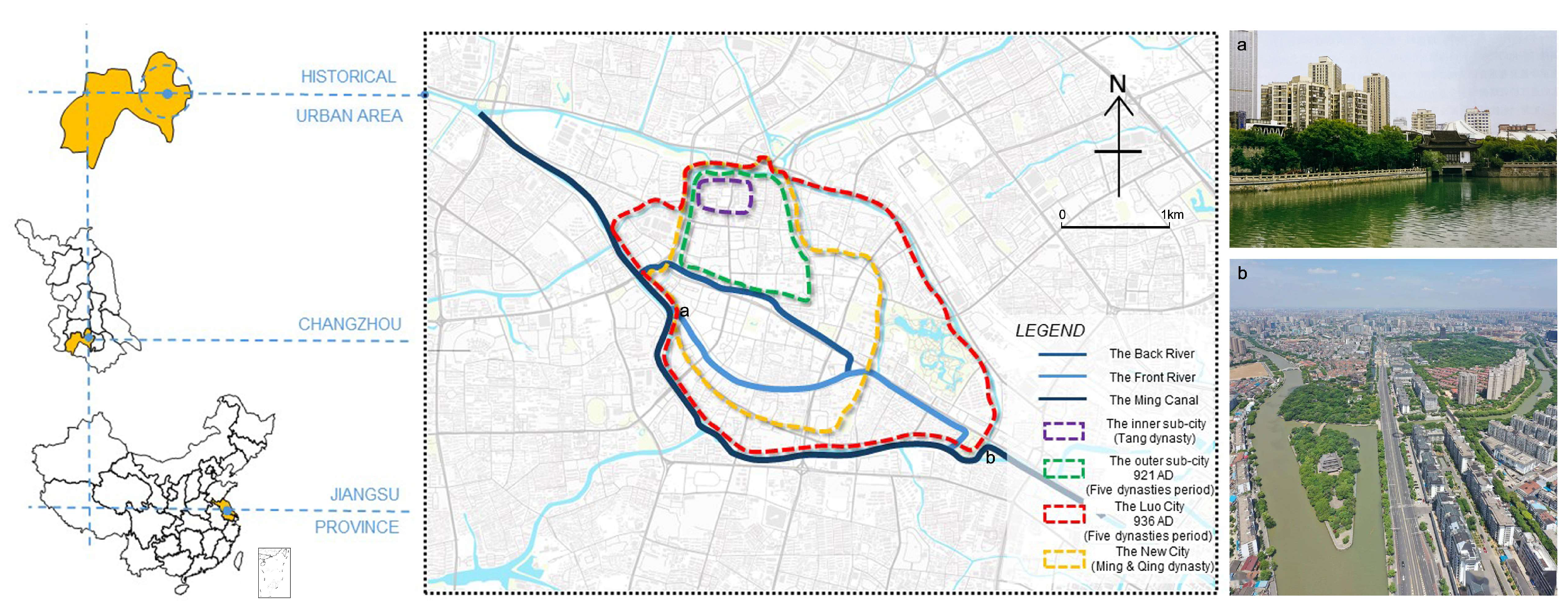
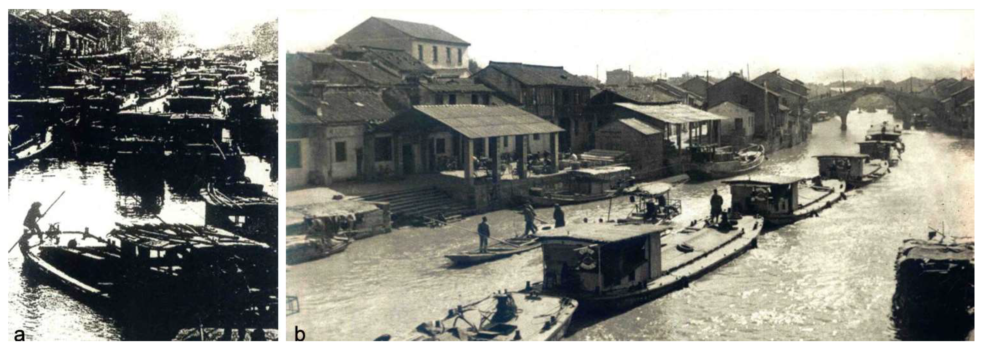
Changzhou (Figure 1) is situated in the northern section of the Jiangnan Canal, within the Yangtze River Delta plain encompassing the Tai Lake area. The third volume of Daoguang WuJin Yanghu County Chronicle, compiled by Li Zhaoluo, a local historian in the Qing Dynasty, stated that “The Piling Pillow River and Lake were interconnected by canals, devoid of mountains and rivers. Their origins lay in the northwest while their courses extended to the southeast. Thus, the canal served as the meridian while the waters acted as the latitude.” The whole territory of the Changzhou Canal was depicted as the primary artery of the water system, with the canal serving as the fundamental axis within the urban spatial context. The Changzhou section of the Grand Canal underwent three diversions, transitioning from traversing the urban landscape, encircling the metropolis, circumnavigating the city [22], and eventually forming a canal network system comprising the most ancient canal on the north bank of the front and back (the Back River, now filled with land), the ancient Qingguo Lane canal (the Front River), the Ming Canal, and the new canal [23]. The urban space along the canal originated from market activities, gained fame as a cultural resort, and expanded through industrial development, reflecting humanity’s ongoing adaptation to the natural geographical environment and the continuous evolution of symbiotic relationships. Simultaneously, the canal water system played a pivotal role in connecting various social spaces in Changzhou City, including military defense, water management, governance and commerce, gardens, and religion. This contributed to the formation of a landscape structure characterized by rivers, streets, and social networks, fostering the dynamic and correlated development of Changzhou City’s urban space [24]. Consequently, it presented a unique cultural landscape shaped by the canal’s presence—an urban space that was both born out of its existence and thrived because of it [25] (Figure 1).
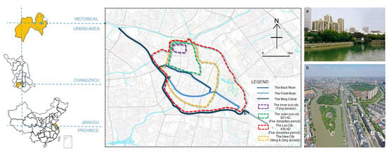
Figure 1.
The evolution of Changzhou Grand Canal and historical urban area. (a) The Canal Urban Landscape at Xishuiguan; (b) Aerial view of the Canal at Dongpo Park [22].
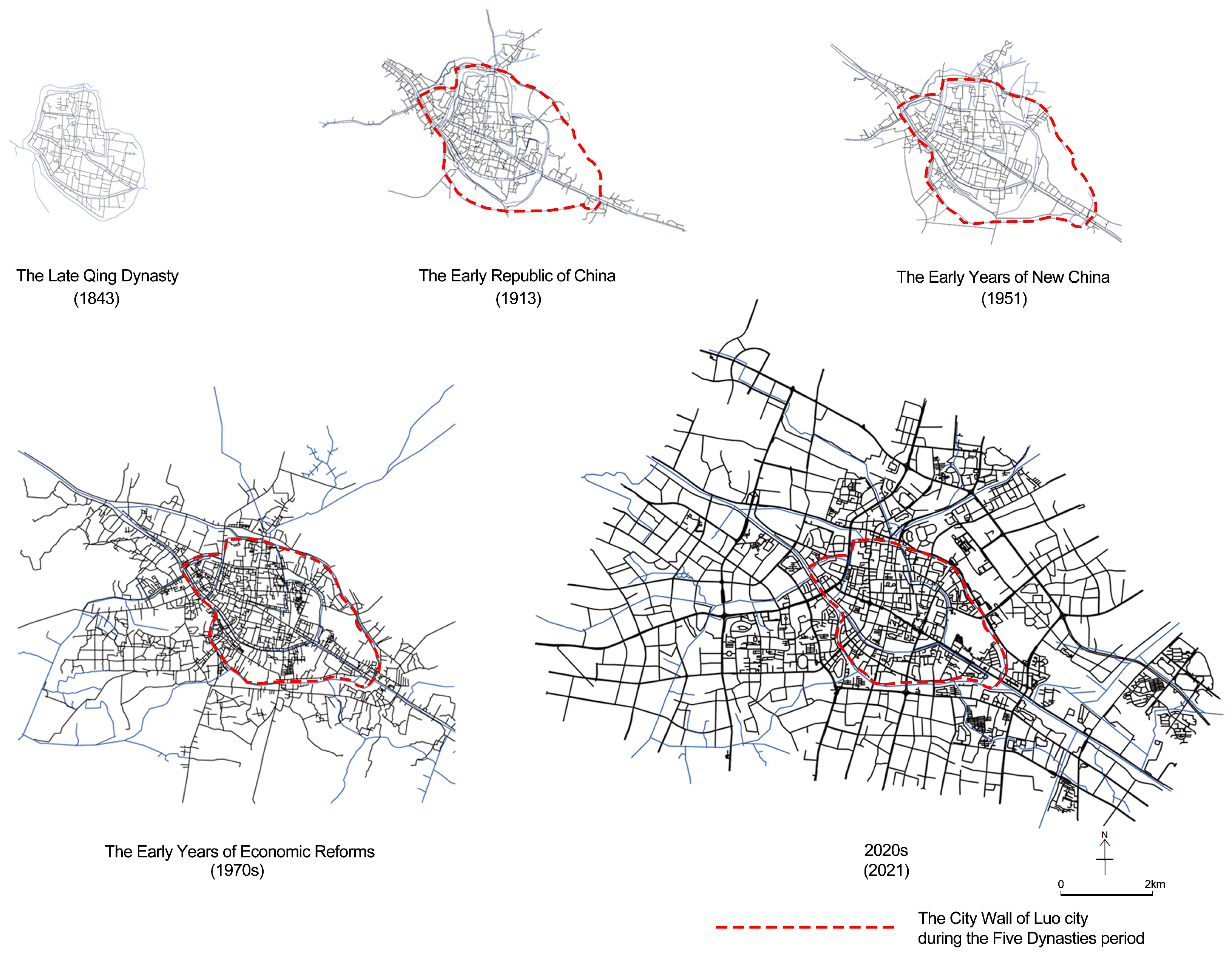
The development of the city wall in Changzhou’s ancient city has undergone four distinct historical phases, encompassing the inner sub-city from the pre-Qin Dynasty to the Tang Dynasty, the outer sub-city and Luo city of the Five Dynasties, and finally, the new city constructed during the Ming and Qing dynasties. This progression has given rise to a spatial configuration characterized by layers of fortified structures. The research scope was defined by the new city of the Ming and Qing dynasties for the late Qing Dynasty period, and by the Luo city of the Five Dynasties for other periods. The boundary of the Changzhou historical urban district from the Republic of China period to the present was determined according to the “Changzhou Historical and Cultural Heritage Protection Plan (2013–2020)”. It encompassed an area of 5.51 square kilometers, with the Five Dynasties Luo city as its core, extending eastward to Yi Zhouting Park, southward to the China Grand Canal (Changzhou section), westward to Suo Qiaowan River, and northward to Guan River (Figure 2).
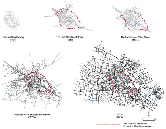
Figure 2.
Research scope across different time periods.
2.2. Research Methodology and Framework
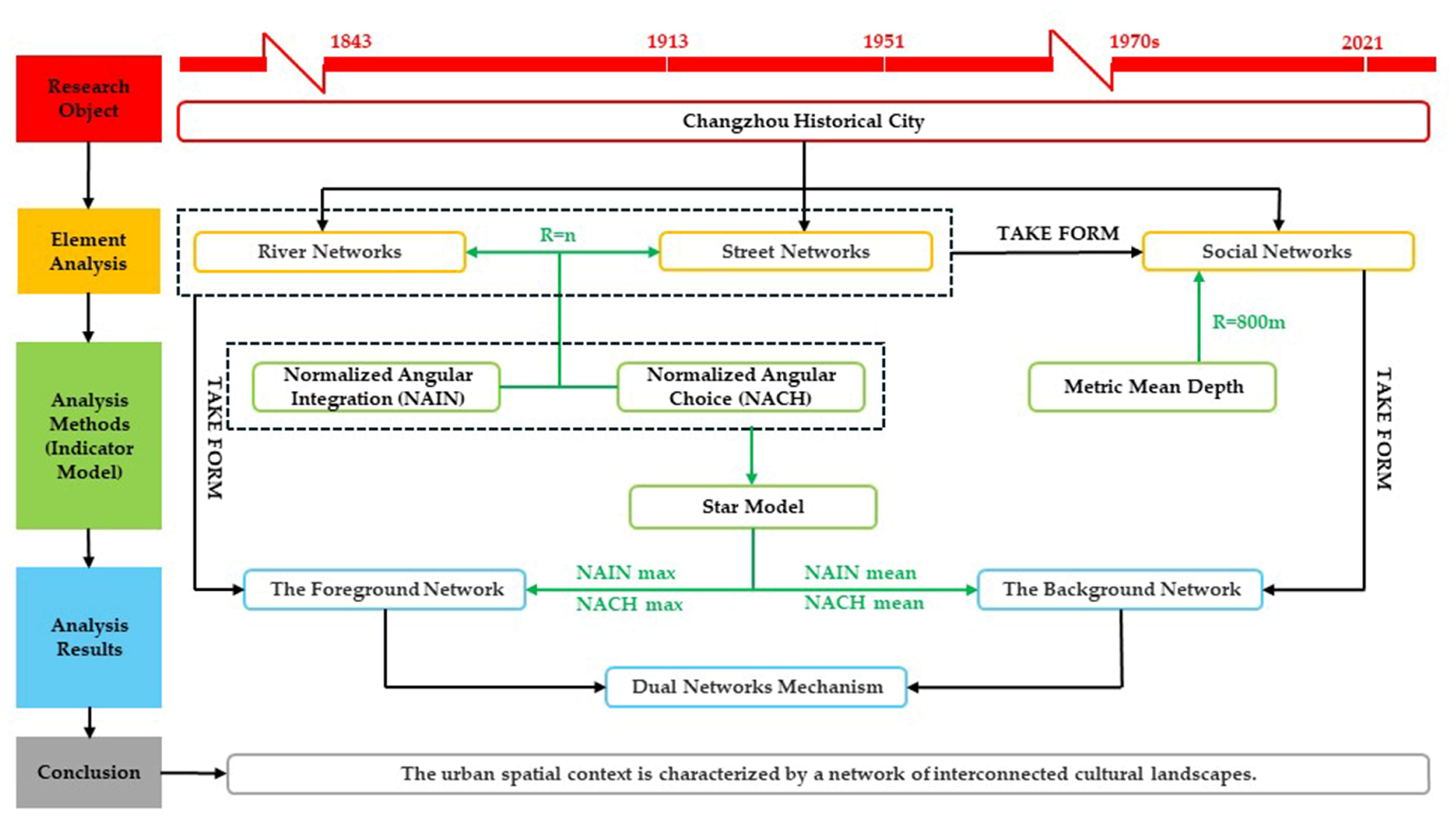
This study utilized the theory of spatial syntax, incorporating foreground and background networks [26,27], to interpret the river–street–social network morphology of Changzhou during a specific historical period. This approach reflected the driving forces behind the continuation of urban spatial context and articulated the cultural landscape characteristics and their formative factors arising from the comprehensive evolution of natural processes, human activities, and social and cultural dynamics. It was seen that the relationships among the above factors were discrete, but the river, street, and social networks in the city could be summarized using Normalized Angular Integration (NAIN) and Normalized Angular Choice (NACH) [28,29] based on map information. The landscape structure framework of the urban spatial network might be delineated by the core integration and choice of street and river networks, serving as the foreground network. The background network, identified through the patchwork partition by the Metric Mean Depth, could elucidate the correlation between urban grids and social networks, while also highlighting the pivotal landscape nodes that contributed significantly to shaping the cultural fabric of the city.
Firstly, the study employed NAIN and NACH as the core indicators to measure the urban spatial foreground network, identifying the city’s global street and river networks. NAIN served as a reflection of overall spatial accessibility, signifying central urban areas, while NACH quantified the likelihood of a specific street or river being traversed by two other streets or rivers as the shortest topological path within the spatial system.
The formulas for calculating the core indicator were as follows:
where NAIN was the Normalized Angular Integration degree, NC referred to the number of nodes and represented the sum of the number of line segments encountered from any line segment to all other line segments, and TD represented the Total Depth, which was the sum of the depth of the shortest angular paths from a particular line segment to all other line segments in the system.
where NACH was the Normalized Angular Choice degree, CH denoted the penetration degree (Choice), and TD denoted the total depth (Total Depth).
NAIN = (NC + 2)^1.2/TD
NACH = log (CH + 1)/log (TD + 3)
Secondly, drawing on the patchwork theory [30,31,32], the Metric Mean Depth was utilized to reveal the spatial aggregation of local streets in the spatial background network and to identify the patchwork partitions that constitute the social network. Utilizing qualitative data from historical maps and documents to serve as an explanatory framework for the syntactic depiction of spatial structure, the model expressed the social network characteristics that emerge in the process of spatial form evolution.
Moreover, the study utilized the “star model” [33,34] of urban morphology to compare the river and street networks across five distinct periods. It further examined the driving forces behind the formation of cultural landscapes, primarily encompassing microeconomic activities and social–cultural dynamics, as well as spatial configuration patterns from a global-to-local and local-to-global perspective. The study utilized the average NAIN value as a metric for assessing the propensity of activity types within both foreground and background networks, while the NACH score (NACH max/ NACH mean) served to elucidate spatial configuration patterns [35,36].
As a result, the following relationships could be obtained:
- (1)
- Low mean NAIN values = A bias towards the drive of socio-cultural activity.
- (2)
- High mean NAIN values = A bias towards the drive of microeconomic activity.
- (3)
- NACH score = NACH max/NACH mean
Low NACH score = Local to Global
High NACH score = Global to Local
The research framework is shown in [Figure 3].
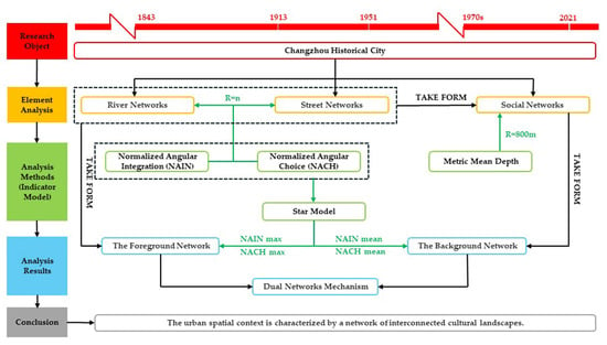
Figure 3.
Research framework.
2.3. Data Acquisition and Analysis
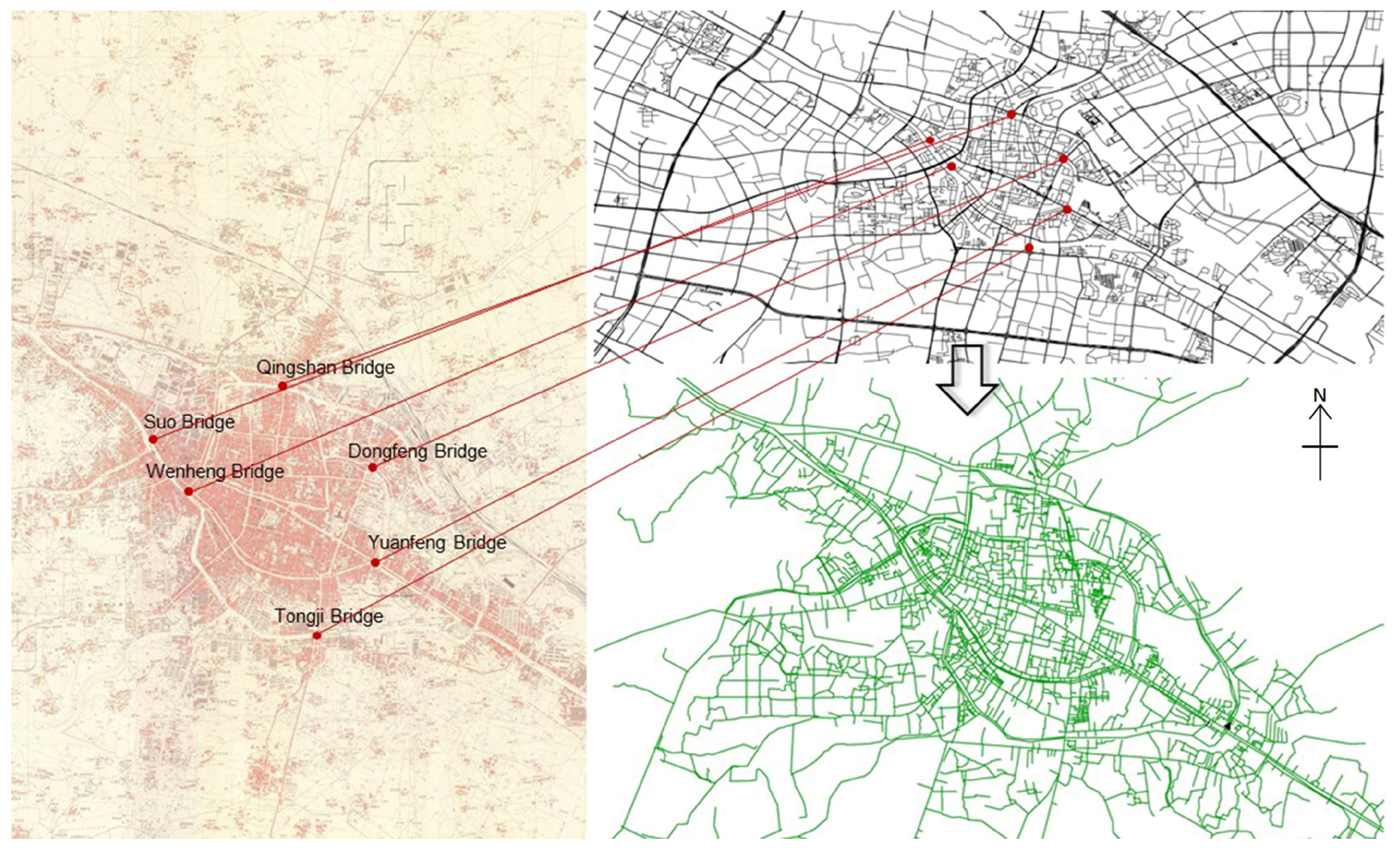
This study aimed to delineate the evolutionary history of the urban spatial context of Changzhou Canal, employing a principle that transforms intricate and continuous changes into distinct historical periods, thereby exhibiting the characteristics of stages and dynamics. Considering the city’s evolutionary traits across different historical epochs, as well as factors such as map data acquisition and cartographic precision, this study focused on five key temporal junctures for spatial syntactic analysis: 1843 (Qing Dynasty’s Daoguang era), 1913 (early Republic of China), 1951 (early founding of the People’s Republic of China), 1970s (early economic reforms), and 2021 (2020s). The five maps were vectorized and georeferenced using ArcGIS 10.5 [37] (Figure 4). Subsequently, the river and street network maps from each period were imported into Depthmap+ Beta 1.0 software for syntactic parameter analysis, the establishment of a topology dataset, and the quantitative analysis of the foreground and background networks utilizing the Normalized Angular Integration, the Normalized Angular Choice, and the Metric Mean Depth tools. The relevant data sources are detailed in Table 1.
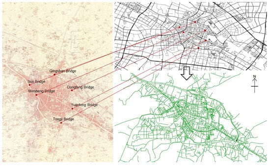
Figure 4.
The diagram illustrates the method of translating historical maps. The left image depicts a historical map from the 1970s, while the upper right image displays a street map with a coordinate system from 2021. The lower right image shows the road map from the 1970s after translation using ArcGIS 10.5.

Table 1.
Relevant sources of authentic maps spanning various historical periods.
3. Results
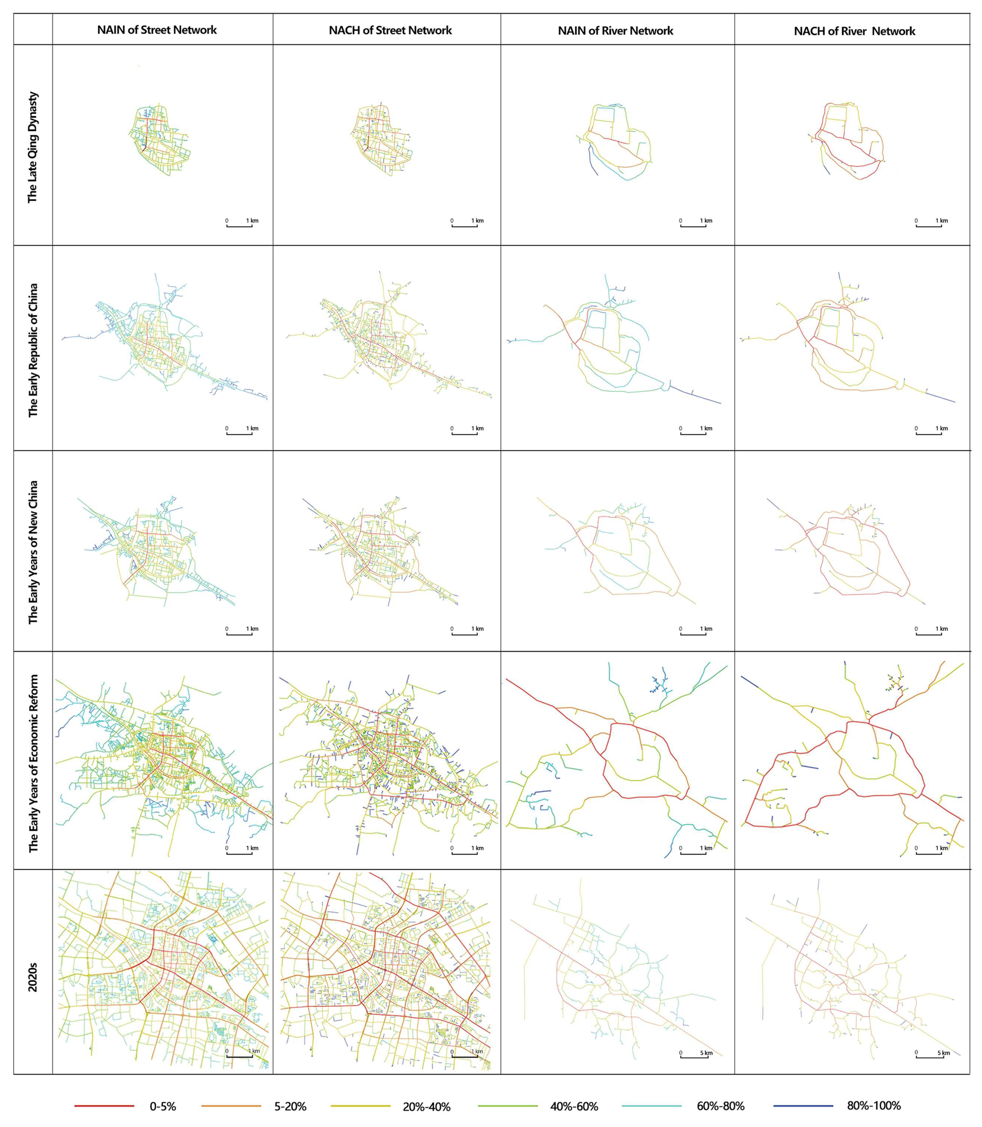
This study conducted a foreground and background analysis of the Changzhou Street and river network, with a global radius set as “n” and a local radius of 800 m (10 min walking distance). NAIN and NACH (R = n) were employed to elucidate the centrality characteristics of the street and river networks (Figure 5). Additionally, the Metric Mean Depth (R = 800) was utilized to identify patchwork partitions within the urban background network [31], while historical data were integrated to assess their correlation with social networks. Through the analysis of the dual morphology of Changzhou’s urban street and river networks, the study revealed the changing characteristics of the street and river network in different periods, as well as the accompanying growth and evolution of land use and social networks, to elucidate the cultural landscape characteristics of the “river-street-society” network within the spatial configuration of Changzhou’s urban context, influenced by the Grand Canal.
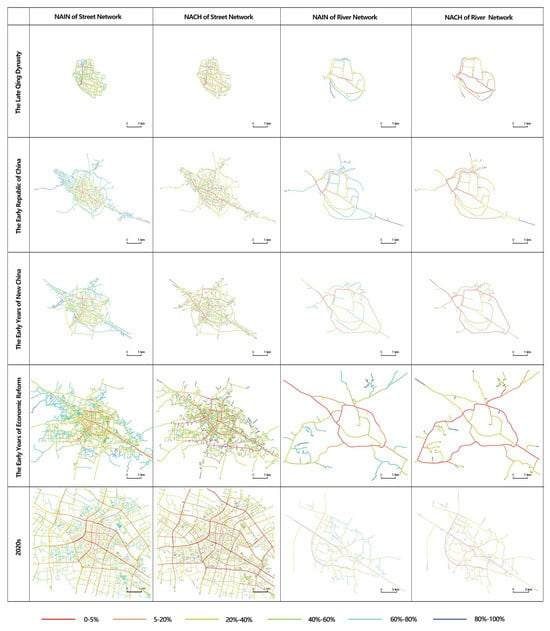
Figure 5.
Analysis diagram of NAIN and NACH (R = n) models for street network and river network.
3.1. The Late Qing Dynasty
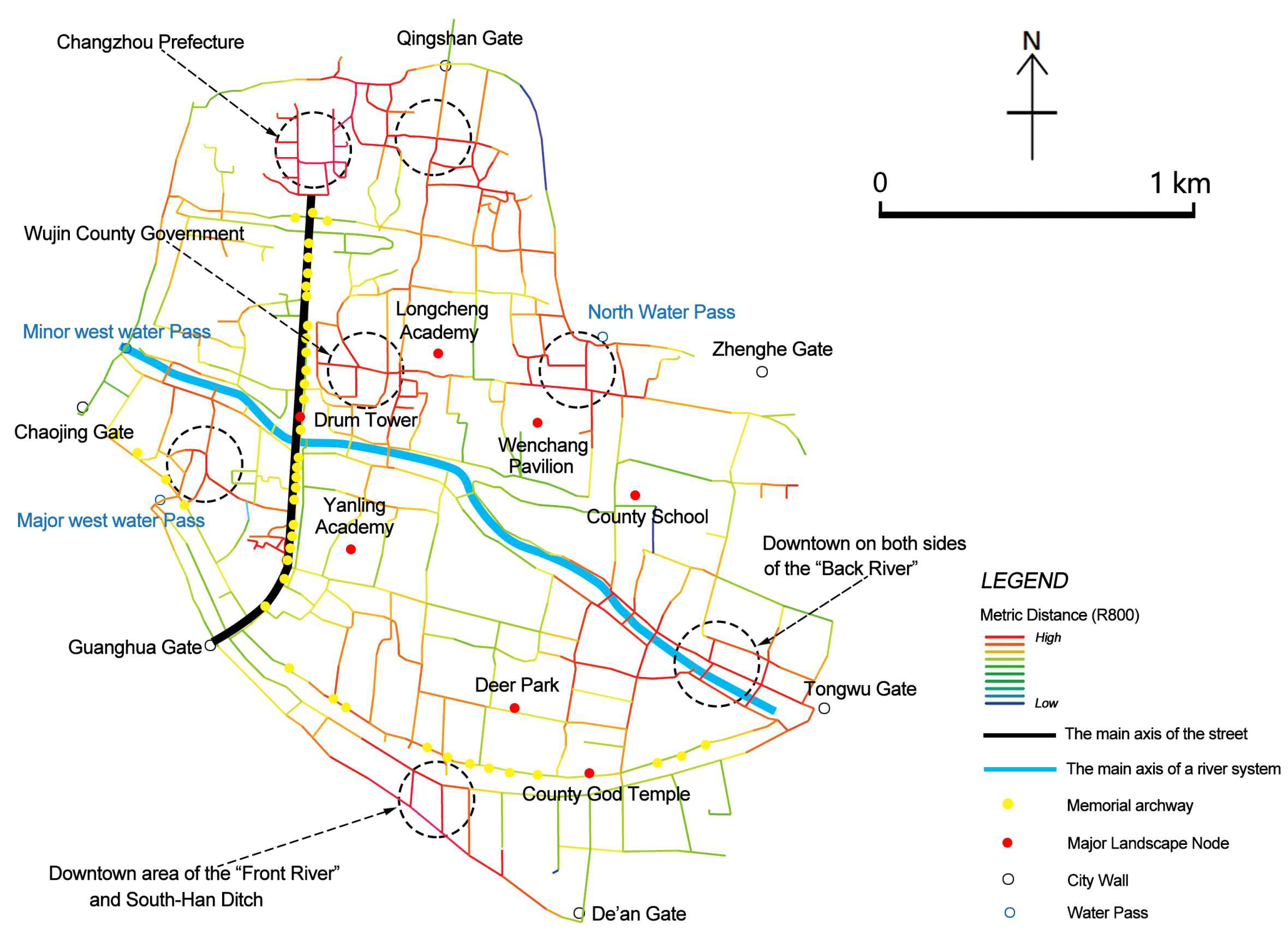
The foreground network analysis is shown in Figure 5: (1) The foreground network is constituted by the core collaboration of streets and rivers. The NAIN core value of the street network points to “Fuzhi Street” and “South Street” leading to Guanghua Gate in front of “Changzhou Mansion”, while the core value of the river network NAIN is displayed along the south moat of the outer city and Gutang River (the Back River), both of which together constitute the core spatial structure of the city. (2) Numerous structures symbolizing ritual thoughts, and the Memorial archway, are installed on both sides of the Core Integration Degree Street (Fuzhi Street). Important cultural landmarks are located symmetrically on both sides of the core river: the county school and the county Chenghuang Temple, Wenchang Pavilion and Lu Garden, Longcheng Academy, and Yanling Academy, and the Drum Tower is located at the intersection of the two core networks. Historical maps clearly show multiple-step patterns along the core river, indicating a strong interaction between residential life and the river. (3) The NACH model of the river network shows the dominance of the canal system for transportation and traffic in the city during this period, and the network of the canal system, as an important basis for dividing neighborhoods, has a significant impact on the spatial configuration of the city. The background network analysis is shown in Figure 6: the city gate effect is significant. In the background network analysis, the patchwork partition formed at the metric distance R = 800 m had some correspondence with transportation nodes, such as city gates and water gates (Figure 6).
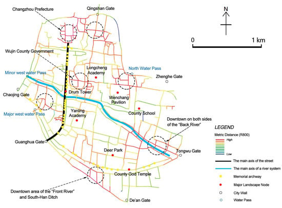
Figure 6.
A chart for analyzing the landscape structure of Changzhou’s urban spatial network during the Late Qing Dynasty.
3.2. The Early Republic of China
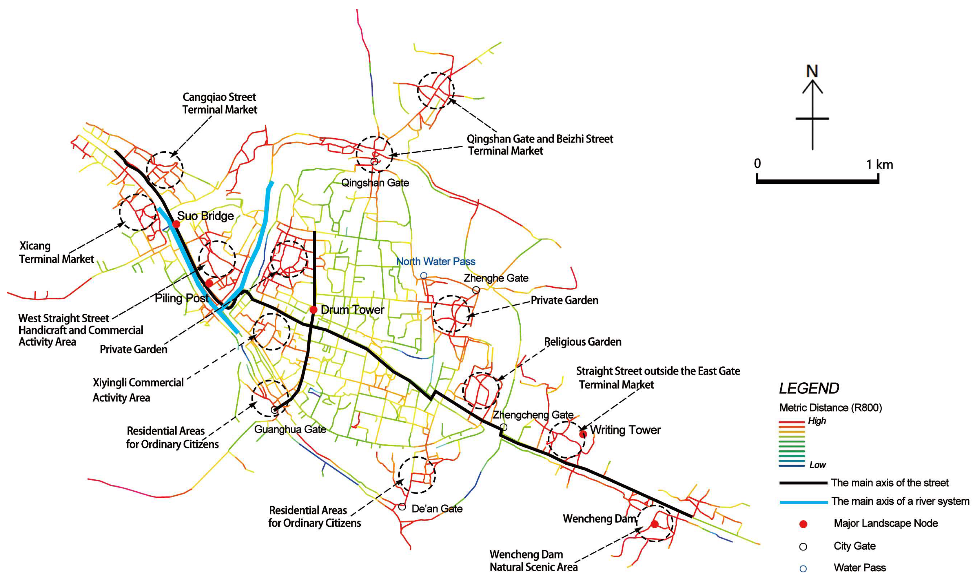
The map from this era indicates that the urban space has transcended the fortified boundaries of the Ming and Qing dynasties, expanding in an east–west direction along the canal in a spindle-shaped spatial configuration. This is evident from the analysis of the foreground network (Figure 5). (1) The core integration degree of the river network and the street network is regionally differentiated. The core integration degree of the river network is concentrated in the water transportation node outside the west gate of the new city as well as around the east moat of the outer sub-city. (2) The street network NAIN shows a “crisscrossing” structure that forms the landscape skeleton of the urban space, replacing the spatial structure pattern of combining street and river in the previous period. The street network NACH shows the internal and external streets connecting the Qingshan Gate in the north, and the east–west straight streets in the suburbs have become highly visited areas, while the “Juxiang Street” area in the east–west direction of the city has increased its choice degree compared to the previous period. (3) The NACH model of the river network shows a high match between the canal water network and the industrial layout. Under the influence of the “traditional internal transformation” in social and economic development [39], as the canal transportation function shifted entirely to the southern part of the city, Changzhou leveraged this function for urban commercial development. Meanwhile, the western region, known as the birthplace of traditional handicrafts, became a hub for trading markets dealing with rice, beans, wood, and various other commodities. In the 14th year of the Ming Dynasty (1519), the “Piling Post” was relocated to this area, establishing itself as the primary port of entry. The surrounding establishments, including wineries, inns, theaters, and financial institutions, served as pivotal hubs for commercial activities among traveling merchants. The emergence of specialized artisanal workshops and ateliers, particularly in the cotton textile industry, was observed in the southeastern region. Furthermore, as the city’s water system increasingly emphasized its scenic and cultural functions, it also led to an enhancement in its interconnectivity.
The background network analysis, depicted in Figure 7, indicates a significant increase in the number of identified patchwork partitions using the Metric Mean Depth, with a concentration along both sides of the east–west axis, demonstrating distinct social and cultural characteristics. Qingshan Gate and Beizhi Street to the north, Tongwu Gate and Dongzhi Street to the east, and Suo Bridge, Piling Post, and Xizhi Street to the west showed the landscape features of traditional handicrafts and commercial activities. North Water Pass and Yingchun Bridge, Guanghua Gate, and De’an Gate to the south, Bazi Bridge and Wencheng Dam, Shilongzui and Tulongzui, etc., where many literati and city dwellers created natural landscapes rich in the spirit of aesthetics and life, have created a group of excellent garden landscapes and residential spaces.
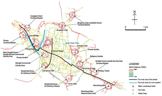
Figure 7.
A chart for analyzing the landscape structure of Changzhou’s urban spatial network during the Early Republican Era in China.
3.3. The Early Years of New China
The analysis of the foreground network is illustrated in Figure 5. (1) The NAIN core value of the street network shows that the structural skeleton of the urban space expands symmetrically to the north and south, and the centrality of the east–west transverse axes decreases significantly. The traditional longitudinal axis forms a cross with Xiyingli Commercial Street to the south, while the East and West Heng streets perpendicular to it to the north show high accessibility characteristics again and establish better connectivity with the suburbs. (2) The river network NAIN and the street network NACH show that both the river and street networks of the canal in the western part of the city have good accessibility, providing spatial structural evidence of the coexistence of wheeled and land transportation in that period. The river network NACH shows a significant decrease in choice degree, since local rivers in the city have become blocked or partially filled. The dominant patterns of both the east–west river and street networks have disappeared compared to previous periods.
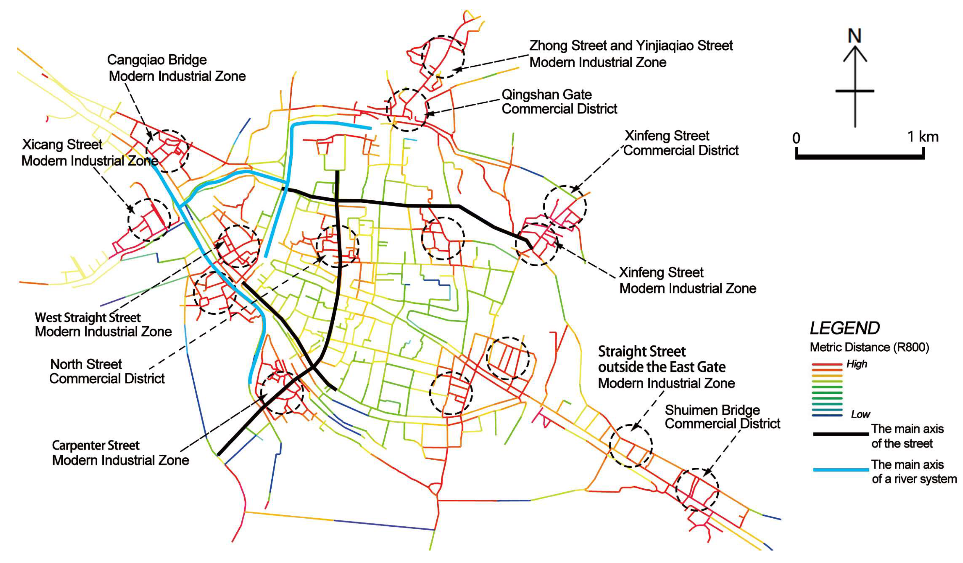
In the context of background network analysis, the Metric Mean Depth identified the main business districts and recent industrial areas clustered in the street network, which were well connected to the high choice degree streets shown by the NACH model of the street network, but discrete from the highly integrated streets shown by the foreground network (Figure 8). During this period, due to the development of modern industry, the urban land area was gradually expanded, showing the characteristics of outward expansion along rivers and roads, and the center of the urban structure was gradually and slowly moved to the south [40]. Modern factories and enterprises have chosen their locations along convenient transportation routes, and the layout was relatively messy, resulting in the crisscrossing of industrial areas and living quarters in the city.
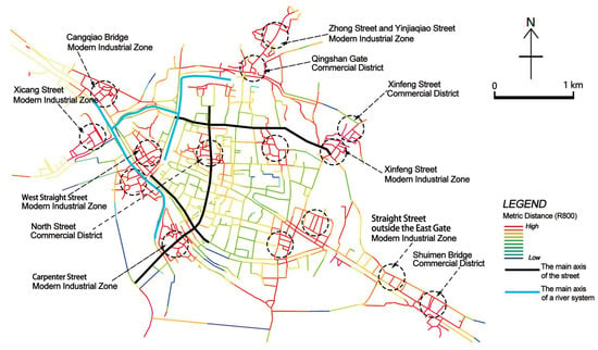
Figure 8.
A chart for analyzing the landscape structure of Changzhou’s urban spatial network during the Early Period of the People’s Republic of China.
3.4. The Early Years of Economic Reforms
The results of the foreground network analysis depicted in Figure 5 indicate that: (1) the street network NAIN core value predicts the restoration and strengthening of the traditional spatial structure, and the spatial pattern of the cross and the symmetrical distribution of the north and south wings become the core skeleton of the urban space. Red Guard West Road and Middle Road in the north (the ancient East and West Heng Street, now Boai Road), Dongfeng Middle Road (now Heping North Road) leading to the railway station in the east, roads along both sides of the Front River in the south, and Shengli North Road (now Huaide North Road) in the west form a ring-like structure. They show a significant increase in the value of integration, and the pattern of urban spatial structure moves from a single type to a composite level. The high connectivity streets displayed by the street network NACH penetrate the southern and northwestern parts of the urban area and have a high degree of consistency with the direction of the canal’s water system. (2) The streets alongside the canal system exhibit a fishbone-like structure. During this era, the urban rivers were extensively infilled to accommodate various urban development and construction needs, leading to the substantial deterioration of the water management infrastructure that previously served military, transportation, and recreational purposes. Consequently, there was a significant increase in reliance on roadways, with industrial facilities and warehouses adopting a “facing away from the river” layout. (3) Against the backdrop of the end of the “Inland River Era” and the opening of the “Wheel Transport Era”, the river network continues to maintain a strong central influence in the east–west direction of the urban periphery (Figure 9) and drives the southern river network to show superior connectivity, providing a basis for the transfer of industrial space along the river.
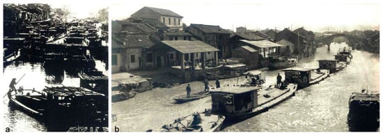
Figure 9.
The canal scenery in the western suburb of Changzhou City. (a) was taken in the 1970s, and (b) in 1977 [41].
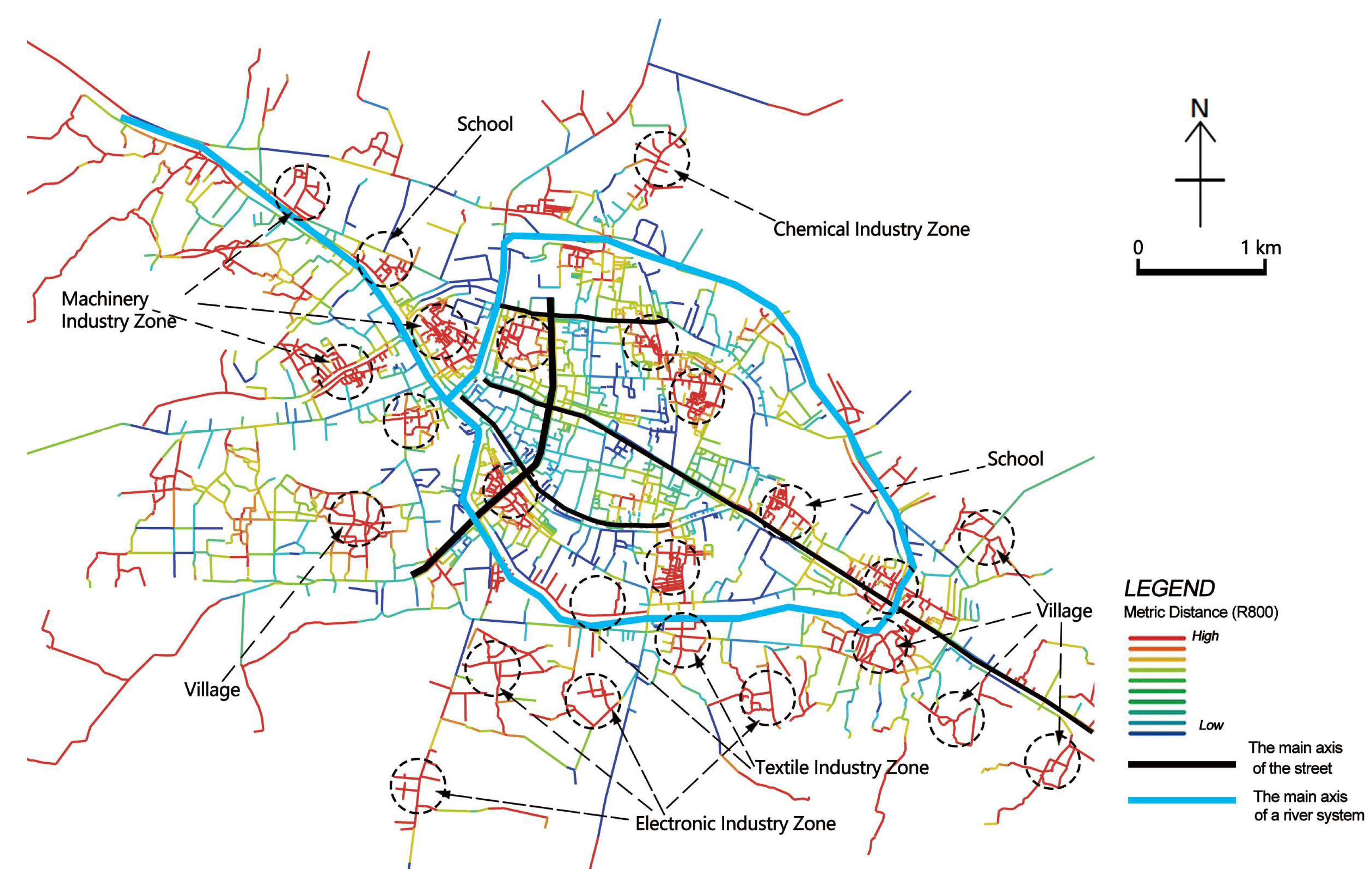
In the background network analysis with R = 800 m, except for the disappearance of the patchwork partition within the eastern gate of the city, the original partitions were sustained, and the newly emerged partitions unfolded in a multi-node and multi-area pattern to the south (Figure 10). During this period, under the influence of the first urban master plan, Changzhou’s urban service function was enhanced through the improvement of public space. However, under the guidance of a planned economy that emphasized production over consumption, the commercial and service industries in the urban areas were suppressed, the parks and green areas were encroached upon, and the heavy industries outside the urban areas were supported to form the urban layout of the machinery industry in the northwest, the electronics and textile industries in the southeast, the chemical industry in the north of the city, and the metallurgical industry in the east of the city [42].
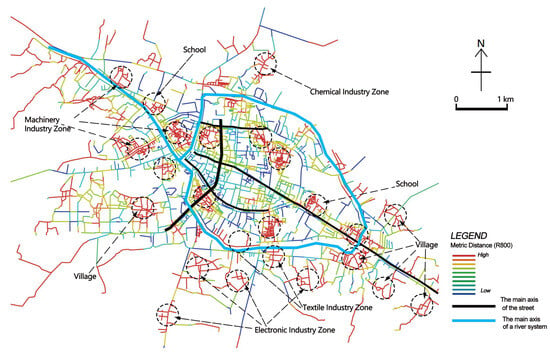
Figure 10.
A chart for analyzing the landscape structure of Changzhou’s urban spatial network during the early stages of economic reforms.
3.5. 2020s
The analysis of the current research findings, as depicted in Figure 5, indicates that: (1) the street network has a significantly higher centrality advantage for north–south oriented roads than for east–west oriented. While the traditional axis of South and North Streets has been well inherited, the number of highly integrated streets has increased to five, achieving a uniform distribution of the foreground network within the historical urban area and driving the expansion of urban space towards the north and south wings. The foreground network of the street network NACH indicates that cities have achieved circular connectivity on a larger scale. (2) The high integration degree river segments in the river network point to the canal route after the third diversion, and the high choice degree river segments include the new canal and the ancient canal.
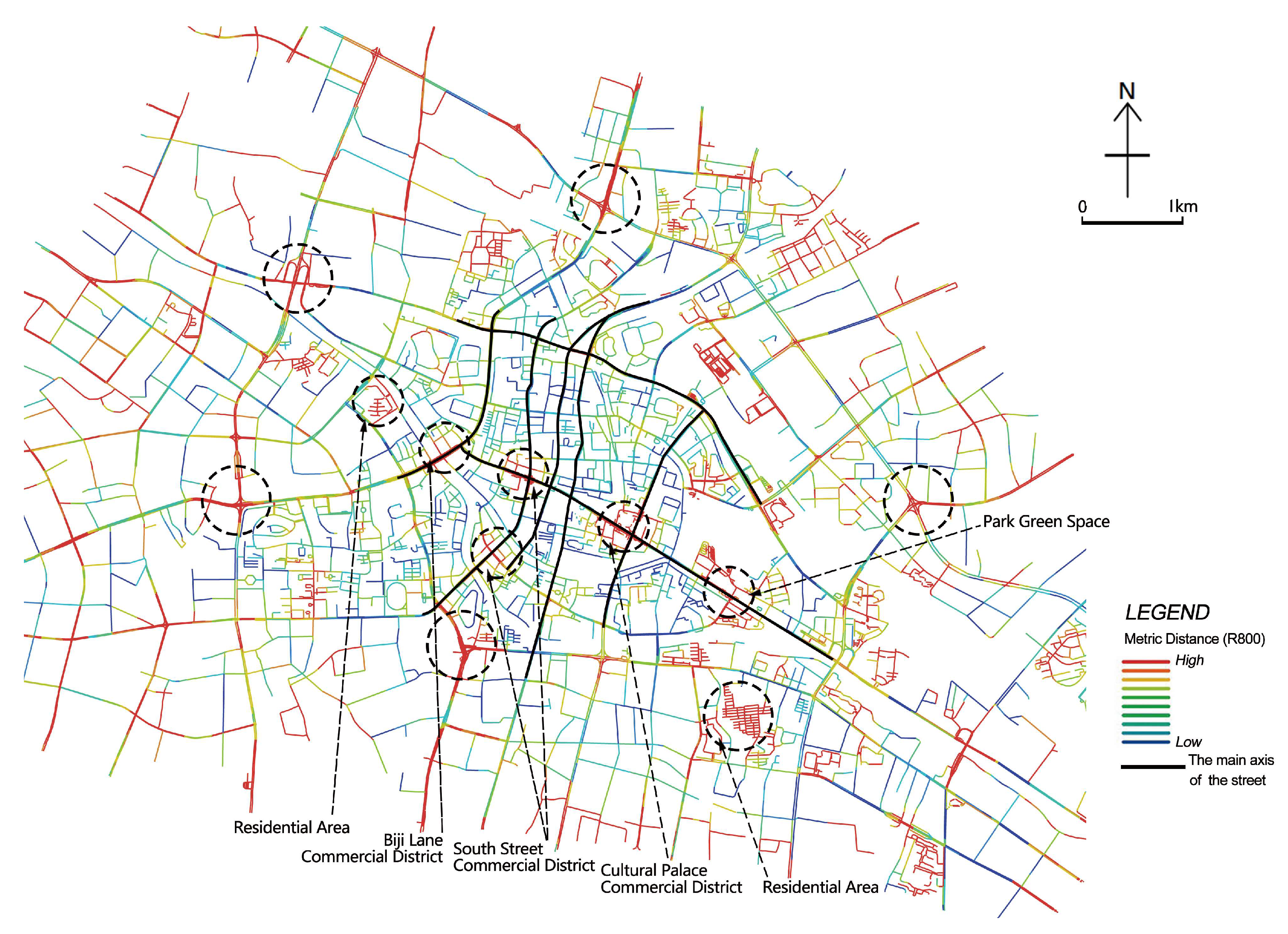
The patchwork partitions shown in the background analysis were dominated by commercial areas and were concentrated along the east–west axis. However, in the vicinity of newly emerging streets with good accessibility, the performance was relatively scattered and sparse, without forming a clear splicing pattern (Figure 11). After the economic reforms, Changzhou has been investigating the principles of reorganizing urban spatial structure under the guidance of a government-led urban master plan. The development of urban space has undergone an evolution from “canals as the axis” to “main road traffic” as the spatial development axis [43]. The modernization of transportation infrastructure, including highways and intercity railways, has emerged as the primary developmental axis and framework for Changzhou under the integrated influence of transportation, industry, and administrative functions. This has given rise to a development model characterized by a highly concentrated central core and outward radial expansion.
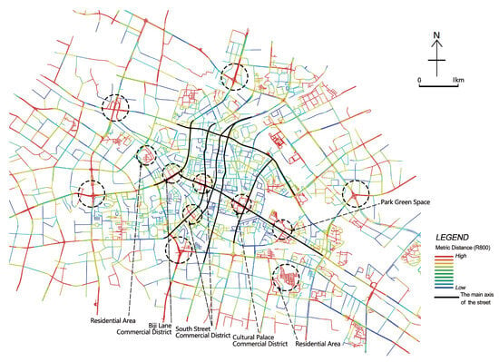
Figure 11.
A chart for analyzing the landscape structure of Changzhou’s historic urban space network in the 2020s.
4. Discussion
4.1. The Driving Forces behind the Formation of Cultural Landscapes in the Spatial Network of Changzhou’s Historic Urban Area
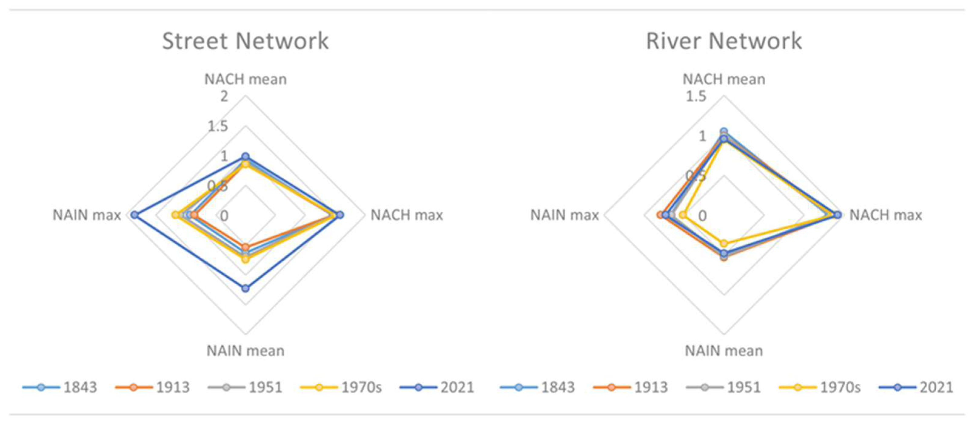
The study utilized the maximum, average NAIN, and NACH to develop a “star model” (Figure 12), which examined the driving forces behind the cultural landscape shaped by rivers, streets, and social networks.
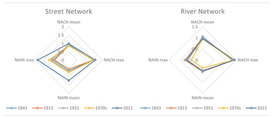
Figure 12.
Star model diagram of street network and river network.
Based on the street network model, the average NAIN value exhibited a consistent upward trend with a minor decline observed during the second period (early Republic era), and a significant increase in contemporary times. The average NAIN results depicted by the river network exhibited a degree of complexity, with the peak value of 0.528 manifesting during the second period (early Republic era). The subsequent two periods witnessed a gradual decline in the values, with the fourth period (early Economic Reforms era) recording a nadir of 0.358. Subsequently, there was a marginal uptick in the contemporary period, although it remained below the peak value (Table 2 and Table 3).

Table 2.
Maximum, Mean NAIN, and NACH for the street network.

Table 3.
Maximum, Mean NAIN, and NACH for river network.
After comparing the results from five distinct periods, the study revealed that the driving forces behind microeconomic activities have gradually surpassed social and cultural activities in shaping the spatial street network of urban areas, emerging as the predominant influence within the foreground network. The river network underwent a prolonged period of degradation following the establishment of the nation, because of construction demands, extensive infilling and channelization, and diminished hydrological connectivity, leading to reduced navigability. Enhanced scenic recreation, cultural function, and ecological environment also supported the notion that the river network was predominantly influenced by social and cultural activities. Considering the prioritization of river ecosystem conservation and integrated management, the river network has achieved enhanced accessibility and connectivity at a broader scale, with the historical urban area transitioning into a localized space. Even without considering human-imposed navigation restrictions, it still demonstrated favorable connectivity. However, it was important to note that at this stage, the river network no longer held substantial practical significance in shaping the spatial configuration of urban transportation functions. The streets were primarily responsible for ensuring efficient and rapid accessibility, as well as shaping the foreground network, while the rivers were more closely integrated with the background network to enhance cultural value and improve its overall functionality.
The NACH score results indicated a consistent change pattern of “low-high-low-high” in the street network and river network during the first four periods. However, in the spatial structure of the fifth period (2020s), the score for the street network was at its lowest at 1.52, while that for the river network reached its peak at 1.48 (Table 4 and Table 5). The low values observed in Periods One and Three signified a spatial composition pattern of cities transitioning from local to global, whereas the high values in Periods Two and Four indicated a spatial composition pattern of cities shifting from global to local. The street network and river network exhibited differentiated patterns in the contemporary context. The street network demonstrated a spatial configuration pattern that spans from local to global, emphasizing the establishment of spatial connectivity within the background network by enhancing connections between local spatial units, thereby facilitating the development of the foreground network. This also signified an initial achievement of urban renewal strategies in shaping spatial structures through meticulous governance. The river network demonstrated spatial organization patterns spanning from the global to local scale, and canal networks that have undergone significant changes over time exerted a catalytic influence on the expansion of urban space.

Table 4.
The NACH score value of the street network.

Table 5.
The NACH score value of the river network.
By analyzing the interactions and correlations among the river network, street network, and social network during five distinct periods in Changzhou, this study has provided an interpretation of the cultural landscape features manifested by the urban spatial context throughout its comprehensive evolution, thus establishing a fundamental understanding, as outlined in Table 6.

Table 6.
The role of cultural landscape in shaping urban spatial context during five key periods in Changzhou’s evolution.
4.2. Research Expansion and Advantages
The study uncovered the urban spatial evolution characteristics of Changzhou’s “city river interaction” beyond historical records, elucidating the underlying social and cultural attributes through foreground and background network analysis. It employed quantitative methods to validate the spatial configuration patterns of rivers, streets, and social networks, integrating historical interpretation and spatial verification to affirm the cultural landscape features of an urban spatial context shaped by natural processes, human activities, and social culture. Furthermore, it examined the driving factors behind this cultural landscape formation, offering an exploratory perspective from the urban spatial substance for interpreting urban spatial context.
The study aimed to conduct an in-depth analysis of the spatial morphology of urban areas and explore its correlation with cultural contexts. The classic methods of urban morphology research can be broadly categorized into three groups: “ morphological analysis” encompassing historical studies of cities, town planning analysis, typological approaches to architecture, and spatial morphology research; “environmental behavior research”, which focuses on the subjective intentions of individuals and their interactive relationship with the environment; and “political economy approach”, which centers on the influence of political, economic factors, and related social organizations in urban processes [44]. The study conceptualized the city as a cultural representation of the landscape and provided an analysis of the cultural landscape characteristics of urban spatial context based on research in spatial morphology. The city of Changzhou possessed distinctive characteristics, with the canal serving as a natural cornerstone for its development, exerting a sustained influence and driving urban street and social network evolution from ancient times to the present day. The analysis of the driving factors and quantitative indicators of foreground and background networks in spatial syntax offered a quantitative research approach for examining the interactive relationships among urban space, natural processes, human activities, and social culture within cultural landscape research. Furthermore, it served as a valuable reference for the preservation of local cultural landscapes.
Simultaneously, certain issues have been identified in the study that require resolution. For instance, by acquiring comprehensive historical data on wharves and bridges, it became possible to employ the “connecting and disconnecting” syntactic axis operation, to obtain more precise quantification results regarding the overlay of street and river networks. This offered a foundation for inferring and reconstructing historical spatial morphological landscapes.
4.3. The River’s Adaptation to Contemporary Urban Spatial Development
On a global scale, the development and evolution of the Changzhou Canal was parallel to that of other countries. The canal, as a significant historical and cultural site, historically functioned as a vital trade route for commodities and a strategic military transportation artery, thereby serving as the economic backbone of early industrialized nations. However, at present, there has been a transformation in the utilization of waterways, presenting canals with similar challenges regarding their usage. Enhanced by extensive research and practical applications, numerous nations have delved into the multifaceted exploration of canal preservation and utilization, encompassing the development of heritage tourism, the sustenance of regional ecological equilibrium, the augmentation of urban dynamism, and the revitalization of urban industrial progression. The Loire River in France, which served as a vital waterway for transportation from the Middle Ages until the late 19th century, witnessed a shift from inland water transport to road and rail networks [45]. Presently, a comprehensive strategy has been devised to safeguard this distinctive World Heritage site, with an emphasis on landscape preservation and the integration of ecological restoration, agricultural advancement, and sustainable tourism [46]. The canals of Amsterdam and Changzhou share similar historical backgrounds, serving as not only the impetus for urban development but also the foundational structure of the city’s central area. As a result of urbanization and the implementation of new waterways, the former port-centric function of the old city center has transitioned to a residential focus. The canals have evolved beyond their original commercial role to encompass diverse urban functions including landscape and ecology, thereby revitalizing the historic city center while safeguarding local identity and urban memory [47,48].
In the process of historical development, the Changzhou Canal has played a crucial role in providing convenience and commercial services for residents, facilitating trade and transportation, and serving as a picturesque leisure destination. Furthermore, it has served as fertile ground for the establishment of modern factories and has accumulated a wealth of cultural resources. However, in the 21st century, with the rise of sustainable development paradigms, environmental consciousness, and cultural cognizance, the navigational utility of rivers within Changzhou’s urban expanse has gradually diminished. Nonetheless, this transformation has been instrumental in optimizing urban layout, cultural functionality, tourism, and leisure amenities, as well as ecological equilibrium. The commencement of the 21st century has witnessed a shift in focus towards tourism and cultural preservation, with the inauguration of a new canal diversion and the repurposing of the city’s original canal as a sightseeing attraction. Looking forward, it is imperative to continue exploring pathways for sustainable development. This exploration should be integrated into the daily lives of residents and encompass a variety of tourism themes.
In conclusion, there is significant potential for the integration of rivers into today’s urban context. By drawing insights from successful case studies in other countries, such as the Loire River in France and the canals in Amsterdam, innovative strategies can be explored to adapt rivers to contemporary urban development in Changzhou. This includes integrating rivers into residents’ daily lives, promoting cultural preservation, enhancing tourism experiences, and maintaining ecological balance.
5. Conclusions
5.1. Reconstruction of the Foreground Network
The street network and the river network served distinct roles in terms of structural mode, functional organization, and role potential during the construction of the foreground network. The north–south street axis, as the fundamental framework of urban space, exhibited a robust continuity gene and initially formed the core structure in conjunction with the river system. As street and river networks underwent functional differentiation, the street network independently evolved into a cross-shaped structure. Through modern transportation advancements, industrial restructuring, and evolving lifestyles, it gradually developed into a multi-level compound structure that now serves as the primary organizing force within urban space. The east–west axis was significantly influenced by the canal, gradually transitioning from the river system to the street form. The river network gradually receded from the foreground network and assumed a prominent role in embodying scenic recreation and cultural value.
5.2. Reconstruction of the Background Network
The patchwork partitions depicted in the background network exemplified the hallmarks of sustainable development and played a pivotal role in perpetuating urban spatial heritage amidst the gradual disappearance of the primary axis in the foreground network. Upon a direct comparison between patchwork partition and plot attributes, it was discerned that there existed a strong correlation between patchwork partition and the functional attributes of plots, thereby serving as influential agents in shaping urban functional patterns. Such an identification could effectively bolster functional differentiation or foster growth in regional identity and characteristics. The identified patchwork partitions had not always been evenly distributed around the foreground network structure in their historical development. The city gates were closely associated with their geographical position during the late Ming and early Qing dynasties, were shifted towards the east–west axis in the late Qing and the early Republic of China periods, experienced structural growth during the modern industrial era, underwent functional renewal and exhibited an incongruous configuration in contemporary space compared to the multi-level compound structure formed by foreground street networks.
5.3. Adaptability of Dual Networks in Contemporary Urban Spatial Contexts
The structural analysis of the double network enabled us to discern the developmental trajectory of the urban spatial structure model of the Grand Canal in Changzhou throughout its historical progression, elucidating diverse structural principles embedded within its seemingly homogeneous spatial configuration. The study revealed variations in functional organization and role potential of the street network and river network across different historical periods, emphasizing that understanding urban spatial culture necessitates the expression and interpretation of spatial structure principles. After entering the contemporary era, streets have gained a distinct advantage in fulfilling traffic functions, with the key lying in harnessing the structural principles exhibited by streets and rivers. Specifically, the river network should be developed in conjunction with the construction of a scenic recreation system, and its structural characteristics should inform both the design of recreational routes and landscape spatial planning. The interpretation of the urban spatial context through the river network should not solely rely on the preservation and continuation of existing cultural heritage, but also incorporate contemporary aesthetic preferences and cater to the satisfaction of experiential senses.
Author Contributions
Conceptualization, J.B., R.C.-H.L. and T.X.; methodology, J.B. and T.X.; software, J.B.; investigation, J.B. and W.Z.; data curation, J.B.; writing—original draft preparation, J.B.; writing—review and editing, J.B., W.Z., C.Z. and P.S.M.; visualization, J.B. and W.Z.; supervision, R.C.-H.L. and T.X.; project administration, T.X. All authors have read and agreed to the published version of the manuscript.
Funding
This research was funded by the “2022 Special Project of Changzhou Grand Canal Cultural Belt Construction Research Institute, China” (Grant no. 2022DYHZX03), the “Philosophy and Social Science Planning Foundation of Tianjin, China” (Grant no. TJSR22-002), the “Seed Foundation of Tianjin University, China” (Grant no. 2024XSC-0036), the “China Scholarship Council program” (Grant no. 202106255014) and the “China Scholarship Council program” (Grant no. 202106255013).
Data Availability Statement
The data presented in this study are available on request from the author. The data are not publicly available due to [privacy].
Acknowledgments
The authors would like to thank Yiwei Pan from the School of Architecture, Tianjin University, Tianjin, China for his inspiration and support in this study.
Conflicts of Interest
The authors declare no conflicts of interest.
References
- Lv, B.; Yang, B.; Zhang, Q.; Duan, D.; Wang, S.; Chen, F.; Chen, T.; Pei, D.; Jiang, W.; Zhou, L.; et al. Predicaments and Confusions in the Inheritance and Shaping of Featured Urban Landscape. City Plan. Rev. 2019, 43, 59–66. [Google Scholar]
- Yuan, J.; Sima, X.; Zhang, J.; Peng, Y.; Wang, Y.; Chen, G.; Duan, D.; Li, Z.; Liu, Q.; Zhang, L.; et al. Crisis of Urban-Rural Identities and Planning Responses. City Plan. Rev. 2018, 42, 34–41. [Google Scholar]
- Zhou, Y. Research on the Application of Conzen’s Theory of Urban Morphology in China. Master’s Thesis, South China University of Technology, Guangzhou, China, 2013. [Google Scholar]
- Yu, Z. Urban Context and Architectural Creation. New Build. 1989, 7, 70–72. [Google Scholar]
- Qi, K. Context and Features: Cultural characteristics embodied in urban forms. Archit. Cult. 2005, 22, 8–13. [Google Scholar]
- Miao, Y. The Value Evaluation of the Elements of Traditional Urban Context in China and the Establishment of a Framework for Inheritance Methods. Urban Planning Forum. 2005, 49, 40–44. [Google Scholar]
- Bao, Y. Urban Cultural Geography and Spatial Contextual Interpretation. Explor. Contention 2017, 33, 41–44. [Google Scholar]
- Haken, H.; Portugali, J. A Synergetic Approach to the Self-Organization of Cities and Settlements. Environ. Plan. B Plan. Des. 1995, 22, 35–46. [Google Scholar] [CrossRef]
- Portugali, J. Self-Organization and the City; Springer: Berlin/Heidelberg, Germany, 2000. [Google Scholar]
- Hillier, B.; Vaughan, L. The city as one thing. Prog. Plan. 2007, 67, 205–230. [Google Scholar]
- Duan, J.; Jiang, Y.; Li, Y.; Lan, W. Space Gene: Connotation and Functional Mechanism. City Plan. Rev. 2022, 46, 7–14. [Google Scholar]
- Karimi, K. The Configurational Structures of Social Spaces: Space Syntax and Urban Morphology in the Context of Analytical, Evidence-Based Design. Land 2023, 12, 2084. [Google Scholar] [CrossRef]
- Zhang, W.; Wang, Y.; Fu, L.; Hu, Y. Scenery Deconstruction: A New Approach to Understanding the Historical Characteristics of Nanjing Cultural Landscape. Herit. Sci. 2024, 12, 62. [Google Scholar] [CrossRef]
- Louf, R.; Barthelemy, M. A typology of street patterns. J. R. Soc. Interface 2014, 11, 19–35. [Google Scholar] [CrossRef]
- Duan, J.; Hillier, B.; Shao, R.; Wang, H.; Rao, X.; Dai, X.; Li, L.; Chen, Y.; Sheng, Q.; Wang, H.; et al. Space Research 14: Spatial Syntax in China; Southeast University Press: Nanjing, China, 2015; p. 43. [Google Scholar]
- Hillier, B.; Hanson, J. The Social Logic of Space; Cambridge University Press: Cambridge, UK, 1984. [Google Scholar]
- Wang, F.; He, J.; Jiang, C.; Li, Y. Evolution of the Commercial Blocks in Ancient Beijing City from the Street Network Perspective. J. Geogr. Sci. 2018, 28, 845–868. [Google Scholar] [CrossRef]
- Yun, J.; Liu, H. Spatial Syntax Analysis of the Evolution of the Water System and Garden Distribution Relationship in Suzhou: 13th–20th Centuries. Buildings 2023, 13, 1703. [Google Scholar] [CrossRef]
- Allahmoradi, M.; Cömert, N. A New Complementary Model for Integrating Historico-Geographical and Configurational Approaches: The Case of Famagusta. Urban Morphol. 2021, 25, 115–136. [Google Scholar] [CrossRef]
- Griffiths, S.; Vaughan, L. Mapping Spatial Cultures: Contributions of Space Syntax to Research in the Urban History of the Nineteenth-Century City. Urban Hist. 2020, 47, 488–511. [Google Scholar] [CrossRef]
- Palaiologou, G.; Griffiths, S. The uses of space syntax historical research for policy development in heritage urbanism. In Cultural Urban Heritage: Development, Learning and Landscape Strategies; Springer: Berlin/Heidelberg, Germany, 2019; pp. 19–34. [Google Scholar]
- Changzhou Center for the Protection and Management of Cultural Relics (Ed.) Study on the Connotation of the Construction of Changzhou Grand Canal Cultural Belt; Cultural Relics Press: Beijing, China, 2020; pp. 8–32. [Google Scholar]
- Wang, J. Dragon City Dragon Vein: The Water System of Changchun Ancient City Transforms with the Grand Canal Serving as its Central Axis; Jiangsu People Press: Nanjing, China, 2020; p. 337. [Google Scholar]
- Wu, X.; Wang, C.; Xu, H.; Sun, Q. A Research on the interaction between the grant canal (Changzhou section) and the urban development. City Plan. Rev. 2013, 37, 61–66. [Google Scholar]
- Xu, X.; Lin, Q. Landscape System of Changzhou Ancient City under the Influence of the Canal. Guangdong Garden 2021, 43, 41–46. [Google Scholar]
- Hillier, B. A theory of the city as object: Or, how spatial laws mediate the social construction of urban space. Urban Des. Int. 2002, 7, 153–179. [Google Scholar] [CrossRef]
- Sayed, K.A.; Turner, A.; Hillier, B.; Iida, S.; Penn, A.; Shibo, G.; Yang, T. Segment Analysis & Advanced Axial and Segment Analysis: Chapter 5 & 6 of Space Syntax Methodology: A Teaching Companion. Urban Des. 2016, 2, 32–55. [Google Scholar]
- Hillier, W.; Yang, T.; Turner, A. Advancing DepthMap to advance our understanding of cities: Comparing streets and cities and streets with cities. In Proceedings of the Eighth International Space Syntax Symposium, Santiago, Chile, 3–6 January 2012; PUC: Santiago, Chile, 2012. [Google Scholar]
- Turner, A. From Axial to Street-center Lines: A New Representation for Space Syntax and a New Model of Route Choice for Transport Network Analysis. Environ. Plan. B Plan. Des. 2007, 34, 539–555. [Google Scholar] [CrossRef]
- Yang, T.; Hillier, B. The Fuzzy Boundary-The Spatial Definition of Urban Areas. In Proceedings of the 6th International Space Syntax Symposium, İstanbul, Turkey, 12–15 June 2007. [Google Scholar]
- Hillier, B.; Turner, A.; Yang, T.; Park, H.T. Metric and topo-geometric properties of Urban Street networks: Some convergences, divergences and new results. J. Space Syntax 2010, 1, 258–279. [Google Scholar]
- Dalton, N. Is Neighborhood Measurable? In Proceedings of the 6th International Space Syntax Symposium, Istanbul, Turkey, 12–15 June 2007. [Google Scholar]
- Hillier, B.; Netto, V. Society seen through the prism of space: Outline of a theory of society and space. Urban Des. Int. 2002, 7, 181–203. [Google Scholar] [CrossRef]
- Hillier, B.; Yang, T.; Alasdair, T. Normalising least angle choice in Depthmap-and how it opens up new perspectives on the global and local analysis of city space. J. Space Syntax 2012, 3, 155–193. [Google Scholar]
- Friesen, J. Star-Models and Urban Development, an Ethnographic and Historical Examination of the Connection between Urban Form and Spatial-Cultures. In Proceedings of the 11th Space Syntax Symposium, Lisbonne, Portugal, 3–7 July 2017. [Google Scholar]
- Suchon, F.; Olesiak, J. Historical Analysis of the Example of Nowy Sacz in Space Syntax Perspective. Guidelines for Future Development of Urban Matrix in Medium-Sized Cities. Sustainability 2021, 13, 11071. [Google Scholar] [CrossRef]
- Yun, J.; Yu, W.; Wang, H. Exploring the Distribution of Gardens in Suzhou City in the Qianlong Period through a Space Syntax Approach. Land 2021, 10, 659. [Google Scholar] [CrossRef]
- Boeing, G. OSMnx: New Methods for Acquiring, Constructing, Analyzing, and Visualizing Complex Street Networks. Comput. Environ. Urban Syst. 2019, 65, 126–139. [Google Scholar] [CrossRef]
- Ye, Z. The City and Culture of Changzhou during the Qing Dynasty: The Exploration and Reinterpretation of Local Literature in Jiangnan. Ph.D. Thesis, Fudan University, Shanghai, China, 2007. [Google Scholar]
- Zhang, J. The Study on the Relationship between the Canal System and the Evolution of the City in Changzhou. In Research on Changzhou Canal; Changzhou Federation of Literary and Art Circles, Ed.; Jiangsu People Press: Nanjing, China, 2014; pp. 28–35. [Google Scholar]
- The Committee for Education, Historical; Cultural Affairs of the Changzhou CPPCC (Eds.) Memory Dragon City. China Party History Press: Beijing, China, 2009; pp. 34–39. [Google Scholar]
- Changzhou Urban Construction Chronicle Compilation Committee (Ed.) Changzhou Urban Construction Chronicle; China Architecture & Building Press: Beijing, China, 1996; p. 3. [Google Scholar]
- Editorial Board of Changzhou (Ed.) Series on Contemporary Urban Development in China. Changzhou; Contemporary China Press: Beijing, China, 2011; pp. 102–106. [Google Scholar]
- Gu, K. The Theory and Methods of Urban Form: Exploring a Comprehensive and Rational Research Framework. City Plan. Rev. 2001, 25, 36–41. [Google Scholar]
- Shao, Y.; Huang, B. Cultural Landscape Conservation and Territorial Development of Loire Valley, France. Herit. Archit. 2021, 23, 92–99. [Google Scholar]
- Région Centre, Région Pays de la Loire, Mission Val de Loire. Val de Loire Patrimoine Mondial Plan de Gestion. Available online: http://www.centreval-de-loire.developpement-durable.gouv.fr/le-plan-de-gestion-du-val-deloire-a2937.html (accessed on 11 August 2021).
- Swart, J.J.; Bakker, K.A.; Veldpaus, L.; Claus KE, A.; Roders, A.P. World Heritage cities: Amsterdam’s canal district case study. In Proceedings of the 3rd International Conference on Heritage and Sustainable Development (HERITAGE 2012), Porto, Portugal, 19–22 June 2012; pp. 175–186. [Google Scholar]
- Pourbahador, P.; Brinkhuijsen, M. Municipal strategies for protecting the sense of place through public space management in historic cities: A case study of Amsterdam. Cities 2023, 136, 104242. [Google Scholar] [CrossRef]
Disclaimer/Publisher’s Note: The statements, opinions and data contained in all publications are solely those of the individual author(s) and contributor(s) and not of MDPI and/or the editor(s). MDPI and/or the editor(s) disclaim responsibility for any injury to people or property resulting from any ideas, methods, instructions or products referred to in the content. |
© 2024 by the authors. Licensee MDPI, Basel, Switzerland. This article is an open access article distributed under the terms and conditions of the Creative Commons Attribution (CC BY) license (https://creativecommons.org/licenses/by/4.0/).

