Article

Localized Canal Development Model Based on Titled Landscapes on the Grand Canal, Hangzhou Section, China

by
Wenli Dong
,
Chenlu Zhang
,
Wenying Han
and
Jiwu Wang
*
School of Architecture and Civil Engineering, Zhejiang University, Hangzhou 310058, China
*
Author to whom correspondence should be addressed.
Land 2024, 13(8), 1178; https://doi.org/10.3390/land13081178 (registering DOI)
Submission received: 5 June 2024 / Revised: 23 July 2024 / Accepted: 29 July 2024 / Published: 31 July 2024
(This article belongs to the Special Issue Urban Landscape Transformation vs. Heritage)

Abstract

:
After the decline of water transportation along the Grand Canal, the integration of urban development and the preservation of cultural heritage along the canal has become imperative. This paper takes the titled landscape as its research perspective and investigates the cultural significance of the canal through its historical, spatial, artistic, and spiritual dimensions, identifying the “Ten Canal Scenes” (TCS) that encapsulate both the canal’s heritage and the unique characteristics of Hangzhou, with the aim of establishing notable urban cultural landmarks. Archival analysis, average nearest neighbor (ANN) analysis, nuclear density analysis, and clustering of resource sites are first used to identify cultural landscape features. Evaluation and decision-making techniques are then used to comprehensively assess and categorize the conservation and utilization value for the TCS based on the value evaluation framework. Finally, it proposes strategies for enhancing the comprehensive values of titled landscapes and addressing socio-economic and cultural dimensions. These efforts seek to reconcile the preservation of the canal’s cultural heritage with the ongoing regeneration and development of the city and propose references for a localized canal development model based on titled landscapes.

1. Introduction

1.1. The Need for Localization of Cultural Landscapes

In 1992, the World Heritage Committee formally introduced the concept of “Cultural Landscape”, defined as “a heritage object that combines humanity and nature, focusing on a wide range of categories such as territorial landscapes, historical spaces, and cultural places” [1]. Put simply, a cultural landscape emerges from human activities interwoven with natural surroundings, embodying connections to historical events, individuals, and activities, or showcasing traditional aesthetics and cultural values [2]. Intangible cultural heritage also forms an important part of the World Heritage values [3].From the perspective of the cultural landscape, scholars have studied the mechanisms of regional town and settlement evolution; for example, Mohammed A. investigated the influence of the traditional value system on the cultural landscape of Alckas Village in Saudi Arabia and its development and evolution process [4], and Wan, M. et al. combined the cultural landscape perspective with the study of the regional landscape protection of historical towns and settlements to construct land use planning methods that integrate urban landscape protection [5].
In recent years, more research worldwide has focused on natural and cultural landscapes like pastures [6], historic orchards [7], and planting landscapes [8]. This has led to a new area of study within historical geography, focusing on cultural landscape assessment [9]. Researchers are placing greater importance on the cultural value and local traditions associated with these landscapes. For example, geo-site assessments reveal the strong cultural ties between communities, particularly indigenous populations, and volcanic landscapes. By enhancing the emphasis on these cultural factors in current evaluation methods, an area’s unique geo-heritage values can be better conserved [10]. Researchers are also exploring how different people perceive and interact with landscapes. This shows a growing interest in involving communities and stakeholders in decision-making about cultural landscapes [11,12].
Research and theories concerning cultural landscapes offer rich insights into the composition and conservation of these landscapes from the perspective of heritage preservation. However, due to cultural diversity, existing international research focuses and objects differ greatly from those in China. Research on local cultural landscapes with unique characteristics is, therefore, not directly applicable, making it necessary to explore the conservation of cultural landscape heritage in China within its own context. This approach should develop a method for protecting and nurturing cultural landscapes that reflects Chinese characteristics and connotations.
The process of researching cultural landscapes in China is mainly divided into three stages: the introduction of the concept of the cultural landscape and the definition of localized concepts, the research on the division of cultural landscape heritage types, and the exploration of the territoriality of cultural landscape conservation. Some scholars took the lead in introducing the concept of the cultural landscape into China [13,14]. Han [15] and Shan [16,17] reinterpret the concept of cultural landscape heritage by promoting extensive research work on the domestic cultural landscape as a form of heritage. Typological studies and indigenous approaches have been the focus of cultural landscape research. For example, Zhou and Li [18] classified cultural landscape heritages in China based on China’s own cultural characteristics. Moreover, Cai [19] and Wang [20] defined and categorized cultural landscapes, focusing on the regional and local characteristics. The existing literature on cultural landscape conservation predominantly focuses on either macro-level conceptual analyses or micro-level case studies, particularly emphasizing villages and cultural heritage. For example, the cultural landscapes of southern Anhui traditional villages have been discussed [21,22]. However, there is a noticeable gap in the theoretical studies and spatial shaping of urban cultural heritage at the meso-level.
As a UNESCO World Cultural Heritage Site, the Grand Canal holds significant importance in navigation, culture, tourism, and recreation. Its extensive influence, elevated status, and diverse value subjects necessitate urgent attention. In 2014, the inclusion of the Grand Canal of China on the World Heritage List marked a significant milestone, highlighting its cultural and historical significance. Subsequently, in 2019, the Office of the State Council of the People’s Republic of China issued a directive aiming for the completion of the Grand Canal National Cultural Park by the end of 2023. The construction of the Grand Canal Cultural Belt has become a major strategic task for national cultural construction in China [23].
The transition from the “conservation of the canal” to the “conservation of the canal city” signifies a new phase in the heritage preservation efforts post-inscription. However, as development pressures increase in the local area, conflicts between heritage preservation and development have emerged. Although numerous studies explore the Grand Canal Cultural Belt, they primarily examine suburban or rural areas in other cities traversed by the canal [24,25,26]. There are fewer studies on urban planning for the type of city center that the canal crosses; for example, Hangzhou, Suzhou, etc. Fewer studies have been conducted on the Grand Canal at the level of urban planning. Hangzhou, with its unique “city–river interdependence”, presents distinct challenges. Moreover, modern urban planning, prioritizing functionality and engineering, often overlooks the poetic nuances inherent in traditional Chinese aesthetics. Therefore, in developing the Grand Canal National Cultural Park, there is a need to cultivate a cultural landscape that integrates with the landscape image of the Grand Canal.

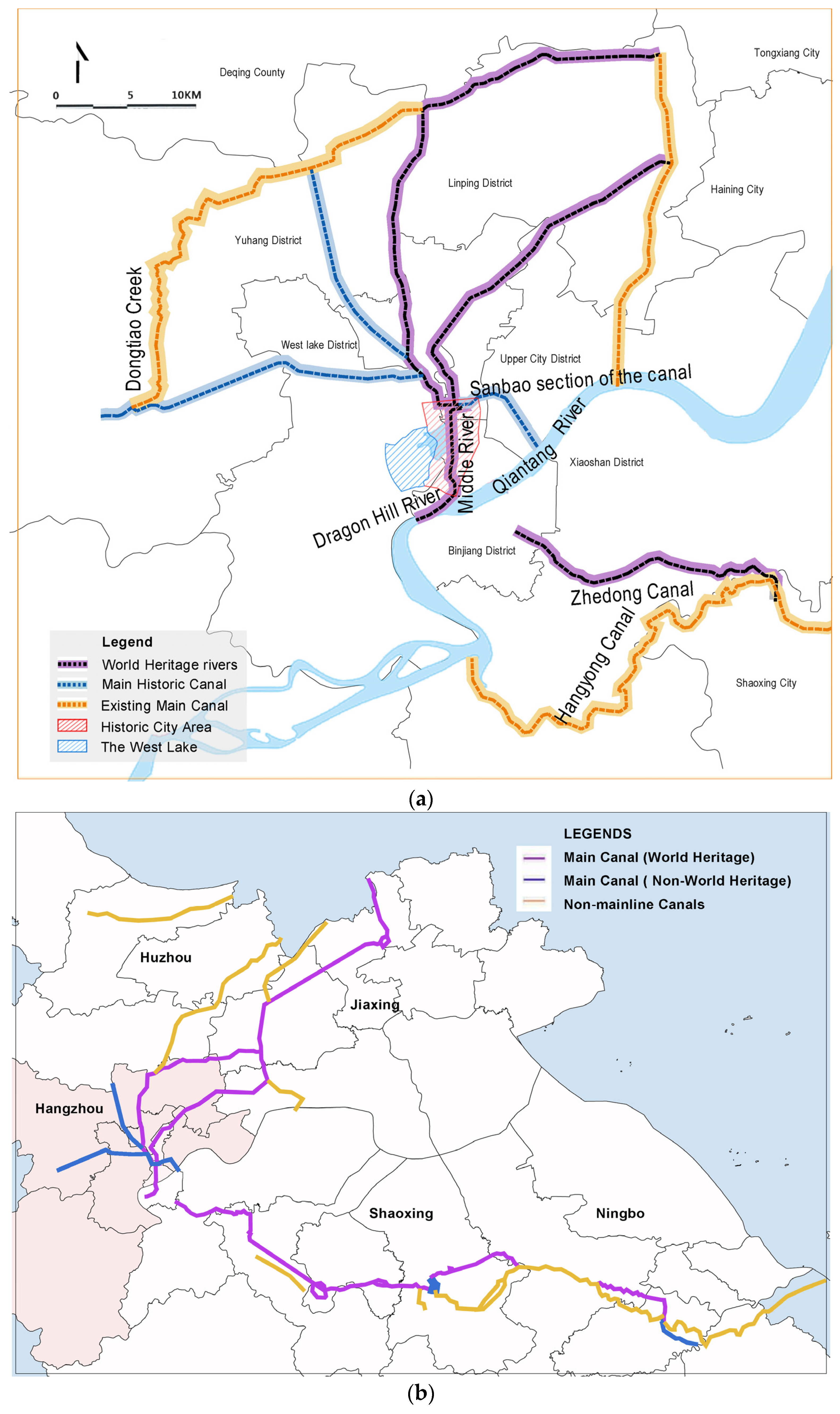
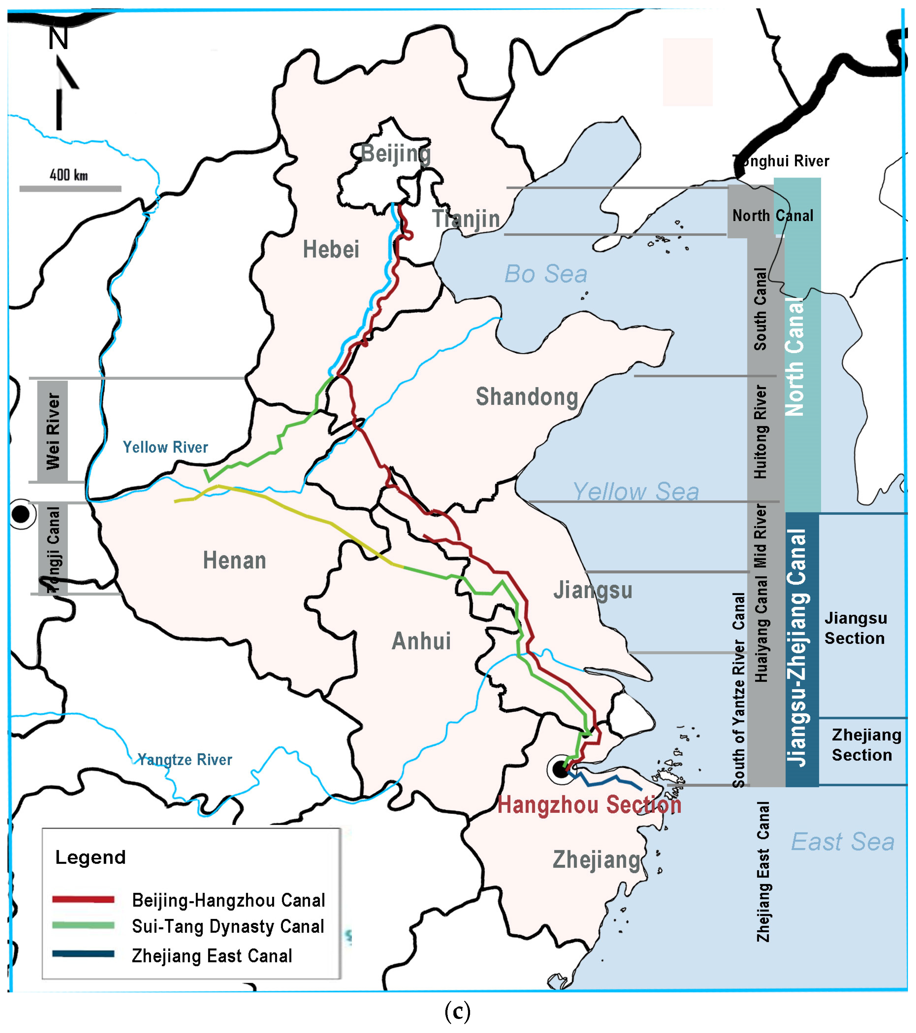
1.2. Conflicts between the Protection, Utilization, and Development of Cultural Landscapes along the Grand Canal, Hangzhou Section

The Hangzhou section of the Grand Canal (hereinafter referred to as the Hangzhou section or “the canal”) includes the section of the Jiangnan Canal from Zhenjiang to Hangzhou. The Hangzhou section (hereinafter referred to as the Hangzhou section) has played a crucial role in the prosperity and development of Hangzhou City in history [27] (Figure 1). However, Hangzhou, as the terminus of the Grand Canal, uniquely integrates the canal with its urban fabric, presenting a distinctive “city and river interdependence” compared to other canal-side cities, such as Beijing, Shaoxing, and Ningbo. Unlike other cities along the canal, where the countryside predominantly borders the river, Hangzhou’s urban development has been closely intertwined with the canal since ancient times. The Grand Canal’s passage through the main urban areas and densely populated built-up surroundings intensifies the conflict between its developmental and conservation values. While the canal served as a vital transportation route in the Tang and Song dynasties, modern transportation has reduced its significance, leading to a weakening interaction between the canal and urban development. On 18 July 2023, with the opening of the Second Canal Passage in Hangzhou’s countryside area, most of the ancient canal’s function of transporting goods will be shifted out of the city and into the countryside. Large areas of linear urban space around the canal are becoming heritage conservation areas or control zones. In the current national spatial planning framework, the development around the canal and in the northern part of the city faces significant constraints. Therefore, there is a need to find a balance between development requirements and control measures, allowing for flexible adjustments while enhancing the landscape along the canal. Transforming the banks of the Grand Canal into vibrant spaces that integrate seamlessly with the city is essential for fostering a sense of community among citizens. In this context, the effective management of conflicts between heritage protection, development, and utilization along the Grand Canal is essential.
Spatial zoning, project management, and other strategies must be optimized to achieve the construction of the Grand Canal National Park and ensure the overall coordinated development of the “city and river” symbiosis. Moreover, there is a pressing need to enhance analytical techniques to manage cultural landscape protection, development, and utilization more effectively. Scientifically exploring and demonstrating methods of protection and utilization will enable sustainable development while preserving cultural heritage.
In light of these considerations, conducting research and discourse from a multidimensional value perspective, and subsequently developing a tailored systematic evaluation system, could yield comprehensive insights into possible future planning approaches. Such an approach, focused on the local context, could facilitate a multidimensional assessment of the “Ten Canal Scenes” (TCS) or “Ten Canal Views” (TCV) that are selected in this paper, aiming a holistic landscape consideration toward types of urban cultural landscapes and offering targeted recommendations for conservation and development initiatives along the Grand Canal.

1.3. Titled Landscapes with “Poetry and Painting Aesthetics”

Deeply rooted in poetry and painting, China’s cultural legacy has significantly influenced urban development through “Poetry and Painting Aesthetics”. This connection is exemplified by iconic landscapes like the “Ten Scenes of West Lake” and the “Eight Scenes of Xiaoxiang River”, which infuse urban spaces with historical and artistic significance. These cultural landscapes are often called “titled landscapes”. They are also referred to as “eight-landscape culture”, in which “eight-landscape” does not specifically refer to eight landscapes, but to the idea of “landscape” as comprising sets of claims in the general sense, that is, certain places have a number of landscapes, such as eight or ten or twelve set together.

1.4. Research Aim

Alongside Hangzhou’s urban renewal and development initiatives, there is an urgent need to select TCS in accordance with the canal’s resources. Unlike the extensively explored cultural significance of West Lake, the canal offers ample opportunity for the development of its cultural functions, especially following the decline of its transportation role. This study adopts a thematic approach centered on titled landscapes to investigate the cultural landscape elements of the canal across historical, spatial, artistic, and spiritual dimensions. By evaluating the cultural landscape’s value, particularly through the TCS model, this research aims to explore the traditional framework and methods to establish impactful urban cultural landmarks. This endeavor seeks to harmonize the imperative to unearth the canal’s cultural landscape with Hangzhou’s urban development goals. It aspires to achieve the preservation, transmission, and promotion of the canal’s cultural heritage while concurrently fostering the creation and personalized management of iconic urban cultural landscapes.

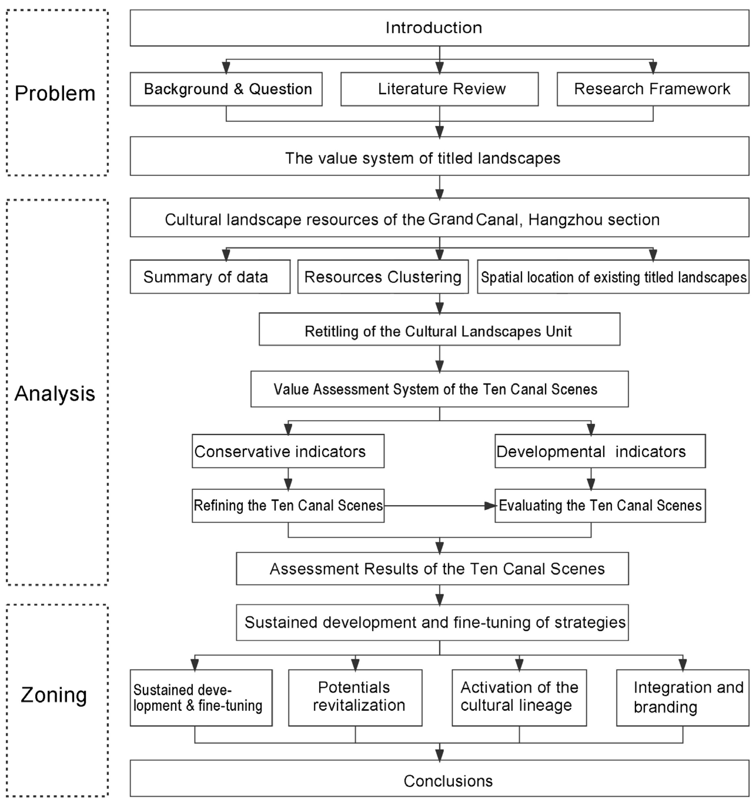
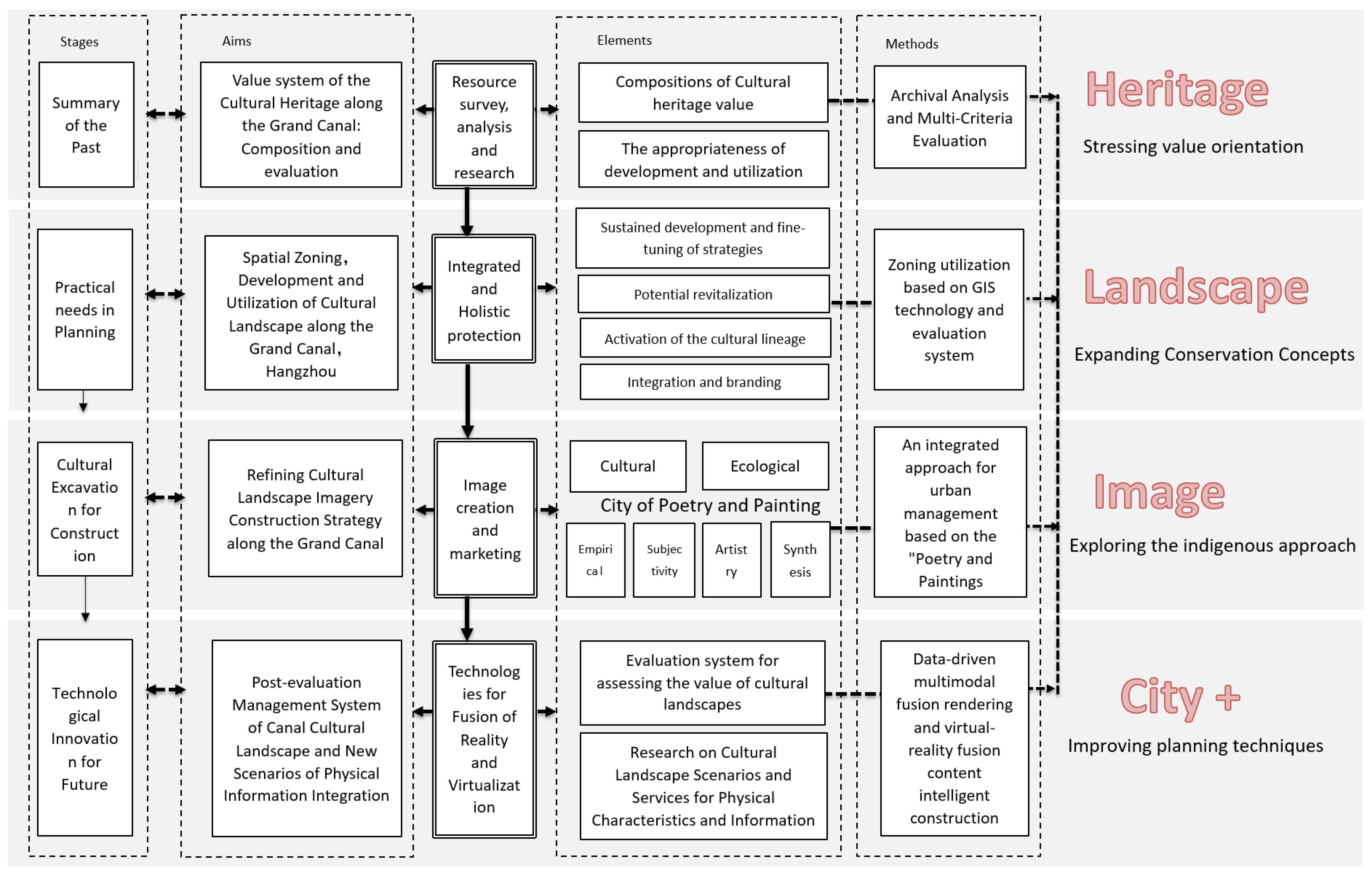
1.5. Research Framework

This paper adopts titled landscapes as its research focus, with a specific emphasis on the canal as the subject of investigation. It systematically classifies and analyzes cultural landscape elements along the canal route, refines the concept of the TCS, and proposes a landscape enhancement strategy for the node spaces associated with these scenes. The main content is structured into the following three stages (Figure 2).

1.5.1. Resources Organization along the Hangzhou Section

The cultural landscape resources along the canal are sorted out. The sample of cultural landscape resources along the canal includes not only heritage historical resources, but also unregistered historical resources, intangible cultural recreational resources, and modern and contemporary architectural landscape resources. Based on the basic data, this paper analyzes the spatial embodiment of cultural landscape resources and the current problems from the definition, classification, distribution, and level of cultural landscape resources, so as to effectively sort them out and extract the title clusters based on the aggregation of resource points.

1.5.2. Assessing the Value of the TCS

The assessment of the current status of the TCS is based on the extraction of clusters and is mainly divided into three parts. The first part constructs a cultural landscape value assessment system based on both conservation and developmental indicators. The second part updates the TCS and proposes new ones so that they are more in line with current realities. By drawing upon conservation indicators and performing a complete examination of cultural landscapes along the canal, this paper aims to inherit and integrate existing titled landscapes while incorporating canal-related cultural elements, Hangzhou culture, poetry, painting, calligraphy, and local chronicles. From this synthesis, this paper aims to extract a set of TCS characterized by rich cultural connotations that creates a lasting impression of Hangzhou. The third part evaluates the value of the TCS proposed in the second part and suggests countermeasures based on current urban development. We begin by evaluating the TCS based on the developmental indicators, and then couple the results of the conservation and developmental indicators. Finally, this paper summarizes them to form the final results of the value evaluation.

1.5.3. Strategies for TCS Landscape Imagery Construction

Based on the assessment outcomes of the TCS, landscapes will be categorized and segmented. Subsequently, tailored strategic recommendations will be formulated for each category of titled landscapes.

2. Literature Review

2.1. Literature Review on the Titled Landscape and the TCS

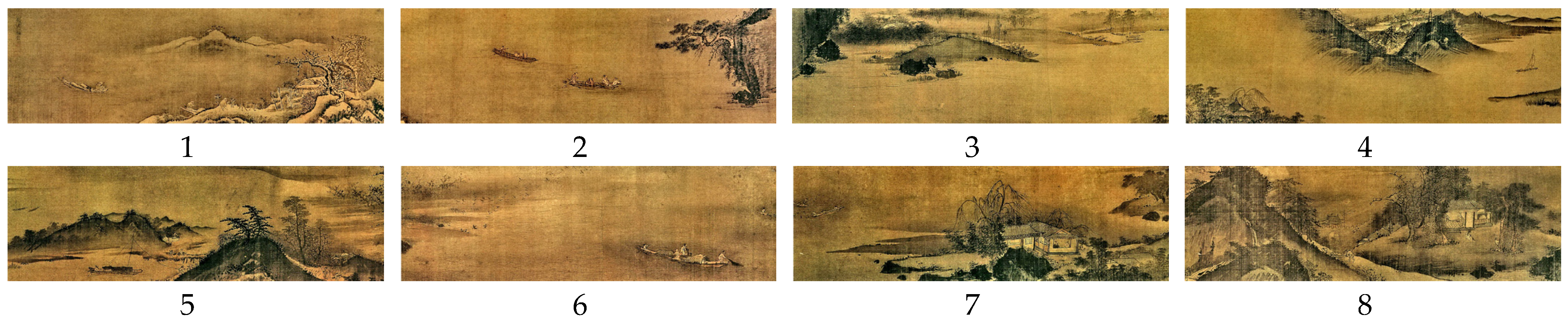
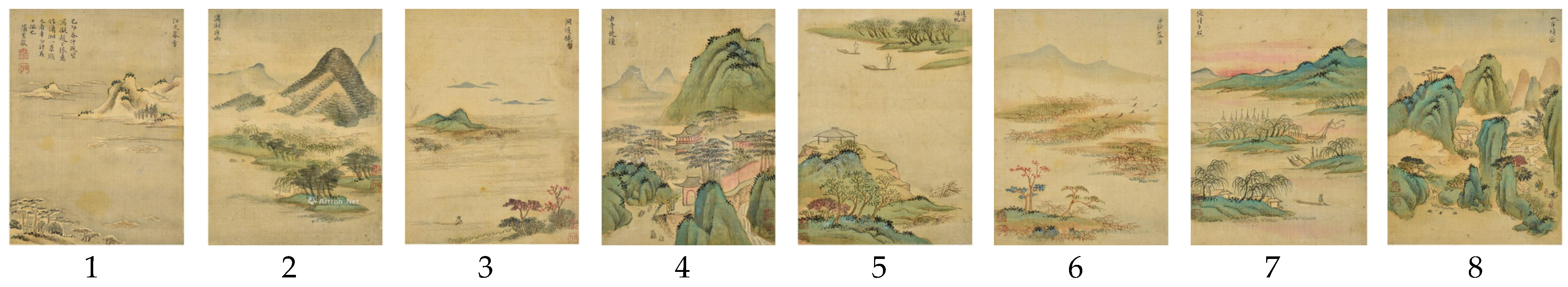
2.1.1. The Origin of the Titled Landscape and Its Spread in Pan-East Asia

Regarding the origins of the eight-scene culture, theories like the “Eight Scenes of Xiaoxiang” [30,31] and “Eight Songs of Dongyang” [32,33] have brought differing interpretations among scholars from Japan, the Korean Peninsula, and Vietnam [13,15]. Scholars generally agree that eight-scene culture originated in the pre-Qin era, sprouted in the Wei and Jin Dynasties, matured in the two Song Dynasties, and achieved prosperity in the Ming and Qing Dynasties [34]; from the Southern Song Dynasty, it became a town space landscape creation mode. Figure 3 and Figure 4 show the TCS of West Lake. From left to right, they are as follows: 1—Autumn Moon on a Placid Lake (平湖秋月)/Deep Cave and Valley on Feilai Peak (飞来洞壑), 2—Admiring Fish at Huagang (花港觀魚), 3—Leifeng Pagoda in Evening Glow (雷峰夕照), 4—Early Spring Morning on Su Embankment (蘇堤春曉), 5—Clouds Between Twin Peaks (兩峰插雲), 6—Evening Bell at Southern Screen (南屏晚鐘), 7—Orioles Warbling on Willows (柳浪聞鶯), 8—Lingering Snow at Broken Bridge (斷橋殘雪), 9—Moon and Candlelight Mirrored in the Lake (三潭映月), and 10—Wine-making Yard and Lotus Pool in Summer (曲院风荷). There is one difference in the composition of the TCS between Lan’s illustration and Ye’s: Lan replaced Autumn Moon on a Placid Lake (平湖秋月) with Deep Cave and Valley on Feilai Peak (飞来洞壑). Feilai Peak is a unique interpretation of the Ten Scenes from the Ming Dynasty. Sun discussed the similarities and differences between the “Ten Scenes of West Lake” and other landscape paintings of West Lake [35,36], and surmised that “image” is the main theme of the Ten Scenes paintings [37].
There are also variations in the painting styles of the different versions of the TCS depictions. According to legend, Song Di of the Northern Song Dynasty selected the scenery at the merging point of Xiangshui and Xiashui in Zuoling, Hunan Province, and painted the Eight Scenes of Xiaoxiang [30,31] (see Figure 5 and Figure 6). From left to right, they can be named as follows: 1—Twilight Snow in the River Sky (江天暮雪), 2—Night Rain in Xiaoxiang River (潇湘夜雨), 3—Autumn Moon in the Dongting Lake (洞庭秋月), 4—Evening Bells in the Smoky Temple (烟寺晚钟), 5—Sails Returning to the Distant River (远浦帆归), 6—Wild Geese Falling in the Flat Sand (平沙雁落), 7—Sunset in the Fishing Village (渔村落照), and 8—Clear Sky in the Mountain Town (山市晴岚). The Eight Scenes of Xiaoxiang were painted in a more poetic style by the Qing Dynasty monk Shangrui (see Figure 6) than by Zhang Y. in the Yuan Dynasty (see Figure 5). These cultural landscapes serve as dynamic representations of cultural heritage, enriching urban environments with historical depth and vibrancy. Their designs go beyond spatial arrangements, integrating elements of time and sensory experiences to create a unique perception of space.
In the 12th century, the titled landscape was brought into Korea by the Goryeo painters, and in the 14th-century Kamakura era, it was brought by monks into Japan [5] and by an envoy into Vietnam [38]. Since then, there was a wave of influence into the other areas around the circle of Chinese civilization and the pan-East Asian region, forming a kind of international Oriental cultural phenomenon. In addition to Chinese scholars who study the titled landscape, scholars in the Pan-East Asian regions such as North Korea, South Korea, Japan, and Vietnam, which have been influenced by Chinese culture, as mentioned above, have also studied it [39].

2.1.2. Similar Paradigmatic Titled Landscapes around the World

There are also various similar paradigms of titled landscapes in Europe, America, and the rest of the world. Although they do not have as long and widespread a history as the titled landscapes in China, nor do they have universal standards and official certifications, they still represent important attractions and cultural landscapes in cities or regions. For instance, dating back to the third century B.C., the traveler Antipater listed the “Seven Wonders of the Ancient World” [40], concentrated in the eastern Mediterranean coastal areas. Other notable sets include the “Seven Wonders of the Middle Ages” [41], the “Engineering Wonders of the World” [42], recognized by the American Society of Civil Engineers, the “Natural Wonders of the World” proposed by Lowell Thomas, and the “New Seven Wonders of the World” [43] initiated by the New Seven Wonders Foundation. Famous cities often have their own sets of designated landscapes, such as Venice, London, Paris, and Berlin. These Western landscapes predominantly showcase magnificent human-made structures such as churches, bridges, and tombs, etc., which are unlike East Asia’s featured poetic and artistic elements. While they hold historical and cultural value, they are primarily characterized by architectural achievements and are less associated with artistic endeavors such as poetry, literature, and painting. Moreover, while these landscapes may share a unified title, the individual attractions within them often lack unique landscape titles. On the other hand, Western countries boast landscapes with similarities to China’s “poetry with paintings” aesthetic. For instance, England’s Lake District inspired Romantic poets like William Wordsworth and Samuel Taylor Coleridge to create numerous poems celebrating its natural beauty. Provence, France, attracted renowned artists and writers such as Van Gogh and Paul Cézanne, whose works have become integral to the region’s cultural identity. Similarly, Tuscany, Italy, renowned for its medieval towns, ancient castles, and vineyards, served as a haven for Renaissance artists and scholars. These regions offer unique natural landscapes intertwined with literary and artistic heritage, forming vibrant cultural tapestries that continue to captivate tourists and inspire artists worldwide. In the 19th century, the Hudson River School emerged as the foremost North American landscape painting movement, capturing the picturesque and sublime grandeur of American landscapes sought by Romanticism. Through their depictions of landscapes and customs, these painters showcased the vast expanse of the United States, particularly emphasizing its majestic scenery to bolster the national identity. This marked a pivotal moment as the United States began to distinguish itself from European influences, gradually revealing its distinctive artistic style [44]. But these areas usually do not title their landscapes with poetry, nor name a group of them collectively, contrasting with the poetic and abstract titles found in Chinese landscapes, such as Autumn Moon over the Tranquil Lake and Broken Bridge with Lingering Snow.

2.2. Literature Review on the Value System of Titled Landscapes

As the concept of titled landscapes originated in China, Chinese scholars and institutions have increasingly delved into this field in recent years. This surge in interest is not only due to academic exploration but also reflects a growing national recognition of its significance within the tourism industry. Stressing the historical value of titled landscapes, refining their cultural connotations, and leveraging their unique historical and cultural characteristics have become focal points for landscape planning and design. According to our literature review, titled landscape value studies can be categorized into the following three main groups based on different research perspectives: historical, cultural, and spatial perspectives (Figure 7).

2.2.1. Historical Value and Traceability Study of Titled Landscapes

The historical value of the titled landscapes is reflected in the function of the “Eight Scenes” as cultural symbols and scenic records, which not only record the local customs, but also retain a wealth of historical information. Therefore, it can be said that the “Eight Views” is a local historical source with important cultural significance and extremely valuable historical data [45].

2.2.2. Cultural (Spiritual) Value of Titled Landscapes

Studies on the cultural value of titled landscapes encompass sociological and cultural analysis, poetic and graphic exploration, and investigations into naming conventions. Poetic and graphic studies examine the artistic expressions and cultural exchange inherent in “Eight Scenes” culture [46,47,48]. “Eight Scenes” culture is a unique art form that has been passed down in many forms, including poetry, painting, cultural exchange, and aesthetic education. The study of poetry and graphic arts is manifested in the exploration of literature, the art of painting, cultural communication, and even aesthetic education.
International research, particularly in Japan and Korea, focuses on the influence of “Eight Scenes” literature and art on their respective cultures. Additionally, scholars analyze the linguistic and aesthetic aspects of landscape names, exploring their conveyance of content, structure, and ideological connotations. Since China’s eight-scene culture is mainly exported to foreign countries in the form of poems and paintings, foreign research on the eight-scene culture mainly focuses on the impact of literature and art fields. For example, a Japanese Chinese literature research expert analyzed in detail the spread of the “Eight Scenes of Xiaoxiang” in Japan and its influence on many fields of art in Japan [49]. Rho J H. and An J L. believe that the “Eight Scenes of Xiaoxiang” have been the driving force of literary aesthetics on the Korean Peninsula since they were imported from the Goryeo Dynasty, and they are considered the classic form of its landscape culture [50,51].
In the study of title naming, because the names of the “Eight Scenic Spots” are mostly four-letter words with condensed and vivid characters, some domestic scholars also focus on the study of landscape title naming when they study the literary nature of the titled landscapes; e.g., Lu made a detailed exposition of the content conveyance, structure, ideological connotation, naming source, aesthetic meaning, and other aspects of the traditional “Eight Scenic Spots” in the titles of the landscapes [48]. Wang discussed the origins and evolution of landscape title naming, the basic requirements for naming the landscapes, which are “cut”, “elegant”, “fine”, and “new”, as well as the materials and techniques for titling the landscapes [52].

2.2.3. Spatial Patterns and Inheritance and Innovation of Titled Landscapes

The spatial patterns of the landscape are inextricably linked to the natural and human context of towns and cities, which are found throughout China, with a significantly higher number in the south than in the north, and a significantly higher number in the east than in the west. During the Ming and Qing dynasties, this situation became even more pronounced. In the fields of literature and art, this eight-scene culture has received a great deal of research, but relatively little has been done to utilize and study it in regional landscape planning [53,54,55]. The protection and restoration of the eight urban scenic spots are mostly combined with modern urban constructions such as parks and green space systems, such as in Ningguo City, which restored and rebuilt the “Eight Scenic Spots of Ningguo” in order to form a new urban park system [56]. Jingning County retains and inherits history and culture by reinterpreting the “Ten Scenes of Hexi”, and has developed them into the “Eight Scenes of Jingning Night” [57]. The West Lake Scenic Area in Hangzhou coordinates the restoration of historical buildings and structures recorded in the “Ten Scenes of West Lake” of different dynasties [58]. The “New Eight Scenic Spots” is an innovative action to protect and restore the traditional eight scenic spots. The “New Eight Scenic Spots” continue the traditional naming method [59], inherit the connotation of the scenic spots, and incorporate new attractions, aiming to enhance the public’s sense of belonging, highlight the local characteristics, and promote the development of tourism [60].

3. Research Methodology of Evaluation

3.1. The Framework of Conservation and Developmental Indicators

The effective protection of historic cultural landscapes and elements necessitates a comprehensive inventory of historical elements [61]. This involves identifying the principles for dividing cultural landscape units that optimize the economic and technical performance of conservation planning while minimizing the need for intervention. Franch-Pardo et al. evaluated the qualities of visibility, quality, and fragility to assess landscapes’ suitability for protection, considering both biophysical and visual landscape aspects. Based on this, they generated maps indicating the suitability of areas for protection [62]. Krajnik, D. et al. analyzed the historical evolution and the natural, urban, and architectural aspects of the cultural landscape, using both general and specific criteria, offering a direction for future interventions aimed at safeguarding historical heritage on the Island of Cres in Croatia and averting damage from subsequent actions, all while promoting the sustainable development of a small historic town [63]. These international studies have demonstrated that the conservation of cultural landscapes requires, first and foremost, a comprehensive survey of heritage resources and a systematic evaluation of indicators.

3.1.1. Evaluation Indicators for the Values of the TCS

With the deepening of the study of the cultural landscape, a variety of interpretive perspectives on the value of cultural landscapes have emerged to carry out theoretical research on the paradigm of cultural landscape values [64,65,66,67,68]. Cao Y. [64] and Fu F. [65] use ephemerality and co-temporality as the evaluation system to measure the historical layers of the time dimension and the landscape characteristics of the spatial dimension. Ephemerality focuses on the complete life cycle of cultural landscape generation and development, and the digging into and protection of historical layers in the time dimension. Co-temporality focuses on contemporary landscape features from a spatial perspective, as well as the identification and protection of landscape features in the spatial dimension. In addition, their theoretical analysis of the cultural landscape value paradigm pays particular attention to the dimensions of human spirituality, such as spiritual value [65], associativity [66], experiential value [67], and so on. For example, Bi X. [68] argues that the concept of wholeness associates nature and culture, promoting their interpenetration, dependence, and coherence. The concept of evolution associates history with the present, recounting the sum of potential landscapes in the process of historical development; this association includes all non-material elements such as history and culture, customs and habits, and the spirit of beauty.
Given the unique “city and river dependence” conditions in Hangzhou, which is significantly differentiated from other canal cities, it is crucial to explore the value coupling mechanism for balancing the preservation and utilization of the canal’s cultural landscape. This includes identifying synergistic mechanisms and promoting the development of a technical system for the preservation and utilization of the titled landscape. Comprehensive evaluation and coupling based on multidimensional factors can offer a viable mechanism for managing value conflicts in the preservation and utilization process of titled landscapes. The study begins with titled landscapes to provide a localized approach to the division of basic units of cultural landscapes.
Based on the relevant literature on the evaluation of the value of the cultural landscape and the cultural characteristics of the titled landscape, this paper argues that the value of the canal’s cultural landscape consists of the spatial dimension, i.e., its holistic value; the temporal dimension, i.e., its evolutionary value; and the spiritual dimension, i.e., its associative value. The primary index layer includes the natural value and the landscape value, corresponding to the holistic association of nature and humanity. The historical value and the development value correspond to the temporal values. The spiritual and cultural values correspond to the association of various intangible elements, such as cultural revitalization, aesthetic spirit, and the spirit of faith. Based on Figure 8, the indicators can be categorized into conservation value and development value according to the change cycle of the value. The conservation value includes historical value, cultural value, and spiritual value. This type of value exists in the process of long-term historical development, with a long cycle of stable value change and high conservation significance. The developmental value includes landscape value, economic value, and social value, and has a high potential for change and a short cycle of change, reflecting its present and future value within a certain period of time (Table 1).

3.1.2. Conservation Indicators for the TCS

The protective indicators primarily encompass the historical, cultural, and spiritual resources provided by the entire cluster (refer to Table 2). For instance, the “Gongchen Invites the Moon” cluster must not only consider the historical, cultural, and spiritual attributes of the Gongchen Bridge itself but also account for resources offered by other cultural landscapes within and around the cluster. The primary objective of these protective indicators is to screen and evaluate categorized clusters based on resource point density, ultimately refining 10 representative cultural scenes with historical, cultural, and spiritual significance.
Historical value is primarily assessed through the number of cultural landscape resource points, calculated as the total number of resource points within the cluster after combining the points of each grade in ArcMap10.8. The protection level of the cultural landscape resource points is assessed by the protection grades of different grade resource points within the cluster, calculated using ArcMap10.8 and the corresponding standards. The classification level of the river in the heritage section is determined based on the Hangzhou Grand Canal World Cultural Heritage Protection Plan, considering the classification of protected river channels within the heritage area. The total number of historical and cultural resource points within the 24 clustered titled landscape areas is tallied using ArcMap10.8. Resource points at each level are weighted according to the weights specified in Table 2 to calculate the total score and grade score of cultural landscape resource points.
Cultural value is primarily determined by the number, type, and protection level of intangible cultural heritages within the clustering area. The selection focuses on contents from the national intangible heritage list, the world-class intangible heritage list, and other grades of intangible cultural heritage items obviously relevant to the canal or cluster area. The evaluation is based on the level of intangible heritage items within the cluster area, divided into three categories: items on the national-level intangible heritage list, items on other levels of the intangible heritage list, and no intangible cultural heritage, for assigning scores.
The spiritual value is primarily assessed by the presence of relevant art works in clustered areas or with titles. Works of art are categorized into traditional (such as poems and paintings), folklore, and modern art forms (such as paper-cutting, photography, and performance art) based on formation time.

3.1.3. Developmental Indicators for the TCS

The primary objective of the developmental indicators is to assess whether the ten clusters, already abundant in the resource supply, can fulfill the needs of residents, tourists, and urban development (refer to Table 3). By integrating the outcomes of both conservation and development indicators, the final assessment result of the value of the TCS can be derived. This assessment offers insights into the supply and demand dynamics of titled landscape clusters, enabling the formulation of strategic recommendations for the TCS.

3.2. Research Methods and Design

The research focuses on assessing the cultural landscape of the canal, employing a comprehensive evaluation approach that considers multiple levels and types throughout the entire process. This involves performing archival analysis, identifying characteristics, uncovering issues, proposing strategies, and summarizing the model for the conservation and development of the titled landscape.

3.2.1. Archival Analysis

The archival analysis method serves as the theoretical cornerstone for this study, complemented by the inclusion of historical literature as one of the research subjects. In constructing the evaluation system, this paper integrates insights from various fields and disciplines, including the selection of the city’s new eight scenic spots, canal-related titled culture, poetry, painting, calligraphy, and local history, and cultural heritage evaluation indices. This synthesis allows the capturing of the disciplinary developments at the forefront and establishes the theoretical framework comprehensively and objectively. Furthermore, literature reviews and archival research were conducted to collect historical documents relevant to our study.

3.2.2. Identification Technology of Cultural Landscape Features

This technology focused on identifying and processing the cultural landscape characteristic elements of the Hangzhou section. It involved research on identifying and extracting the historical cultural landscape elements and pattern characteristics. This process included constructing a database to facilitate the comprehensive and diversified excavation of potential canal cultural landscape resources.
The research also explores cultural landscapes that harmonize with the city’s topography, geomorphology, climatic characteristics, spatial patterns, and distribution of historical environmental factors. The unit division scheme aims to reflect the linear heritage characteristics of the canals, emphasize the central role of units at anchorage points, and acknowledge the uncertainty and ambiguity of unit boundaries. Additionally, it considers three-dimensional spatial information such as the threshold of human vision. By standardizing the scale of data sampling, we ensured consistency with feature patches.
Geographic Information System (GIS) spatial analysis was adopted to analyze spatial data, including the spatial location, distribution, morphology, and other information of geographic objects from spatial data. In this paper, the combing and clustering analysis of cultural landscape resources was based on the spatial analysis method embedded in Arc Map 10.8 to assist in decision-making.

Average Nearest Neighbor (ANN) Analysis

All resource points were de-ranked and merged in ArcMap10.8 for average nearest neighbor analysis by first measuring the distance between the center of mass of each element and the location of the center of mass of its nearest neighboring element; then, we calculated the average of all these nearest neighbor distances. If this average distance was smaller than the average distance in the hypothetical random distribution, the analyzed distribution of elements was considered as clustered elements. If this average distance was greater than the average distance in the hypothetical random distribution, the elements were considered as dispersed elements. The ANN was calculated by dividing the observed average distance by the desired average distance (see Appendix A.1).

Nuclear Density Analysis

Kernel density analysis uses a kernel function to calculate a measure per unit area based on point elements to fit individual points to a smooth conical surface, allowing for visualizing the abundance of resource points. The search radius has no effect on the value of the kernel density, but it does have certain effect on the final visualization and analysis results. If the search radius is too large, the surface of the kernel density is too smooth, resulting in hotspots of the study being covered up and features not being obvious; if the search radius is too small, the surface of the kernel density is uneven, which can reveal the features of the small localities but cannot ensure the continuity and correlation of the large-scale data.

Clustering of Cultural Landscape Resource Site Analysis

Based on the spatial landing and organization of the existing titled landscapes, including merging, deleting, and retitling, the current situation’s cultural landscape clustering was derived.

3.2.3. Evaluation and Decision-Making Techniques

Refinement of the TCS

After selecting clustered titles based on the results of kernel density analysis, the titled landscape clusters were quantitatively scored and ranked according to the value indicators, in order to refine the TCS. The above three evaluation indexes were integrated, and the scores were normalized to the maximum–minimum value, which means that the data are scaled according to the maximum and minimum values, and are announced as follows:
y = x m i n / m a x m i n
where x is the original data, y is the normalized data, and min and max are the minimum and maximum values of the original data, respectively. After obtaining the score normalization results, we then assigned weights for each item and then calculated the weighted sum. The total score could be obtained by directly adding the normalized results, and then the total score was sorted in descending order, and the top ten were identified as the TCS.

Comprehensive Assessment of the Conservation and Utilization Value of the “Ten Canal Scenes”

Conducting field surveys of various cultural landscapes along the canal was essential. This involved evaluating key elements, conducting stakeholder interviews, analyzing the literature, and synthesizing theories and indicators for screening and evaluation. The field survey data could be quantified to ensure that the research is scientific and accurate. By normalizing the scores of conservation and developmental indicators and then calculating the total score, the current assessment results of the TCS were obtained.

4. Results: Cultural Landscape Resources of the Grand Canal, Hangzhou Section

4.1. Summary of Data on Cultural Landscape Resources

Contemporary cultural landscape projects in Hangzhou were mapped using Arc Map 10.8, summarizing resource points based on various categories such as national key cultural heritage units, provincial cultural heritage units, municipal cultural heritage units, municipal cultural heritage points, other historical and cultural resource points, historical buildings, industrial heritage points, and contemporary cultural landscape resource points. The resulting distribution map of organized cultural landscape resource points is illustrated in Figure 9a.

4.2. Clustering of Cultural Landscape Resources

4.2.1. Average Nearest Neighbor Analysis

After the average nearest neighbor analysis of all resource points, the value of the ANN was obtained, i.e., the nearest neighbor ratio is 0.304308, from which it can be concluded that all cultural landscape resource points are significantly clustered in space.

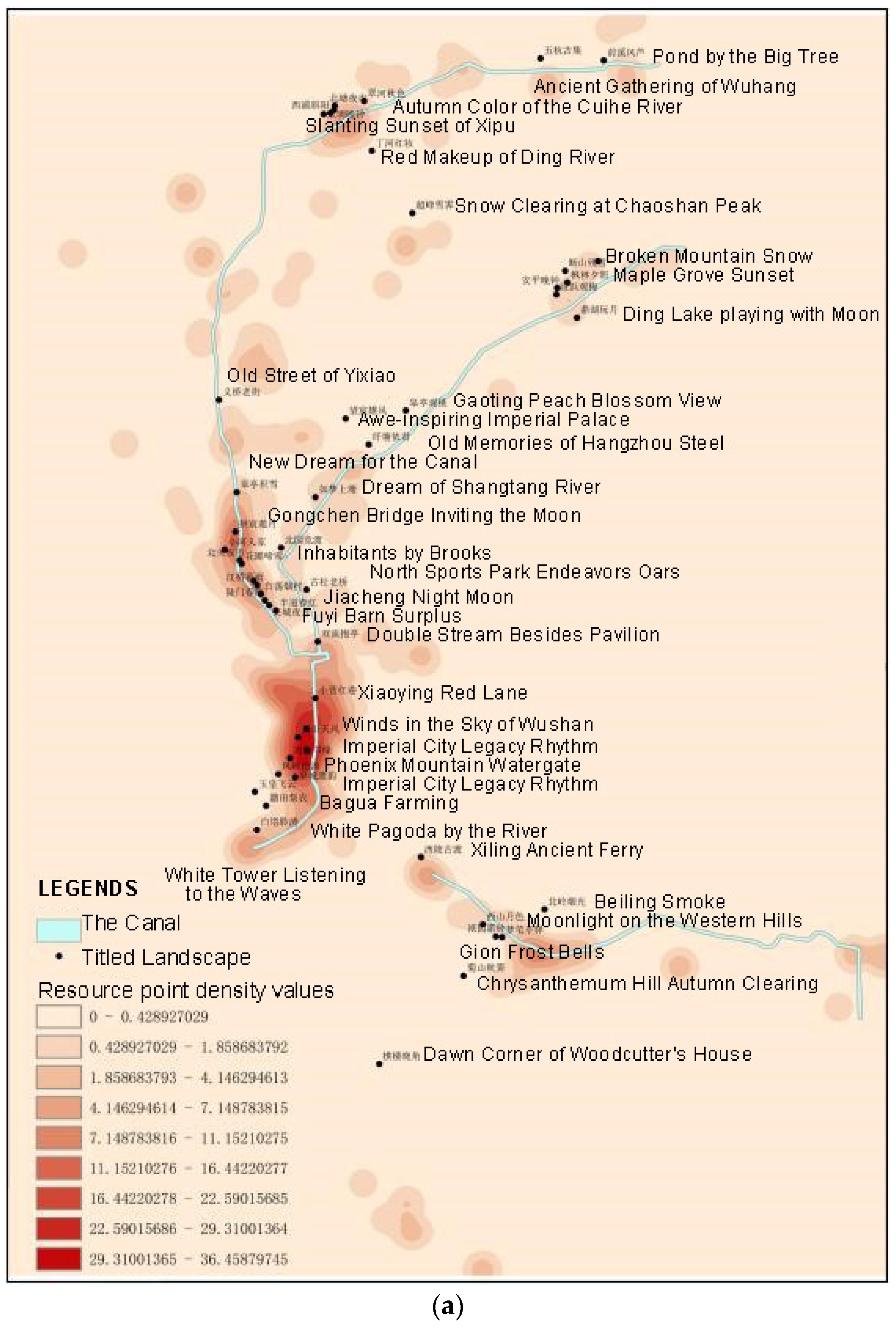
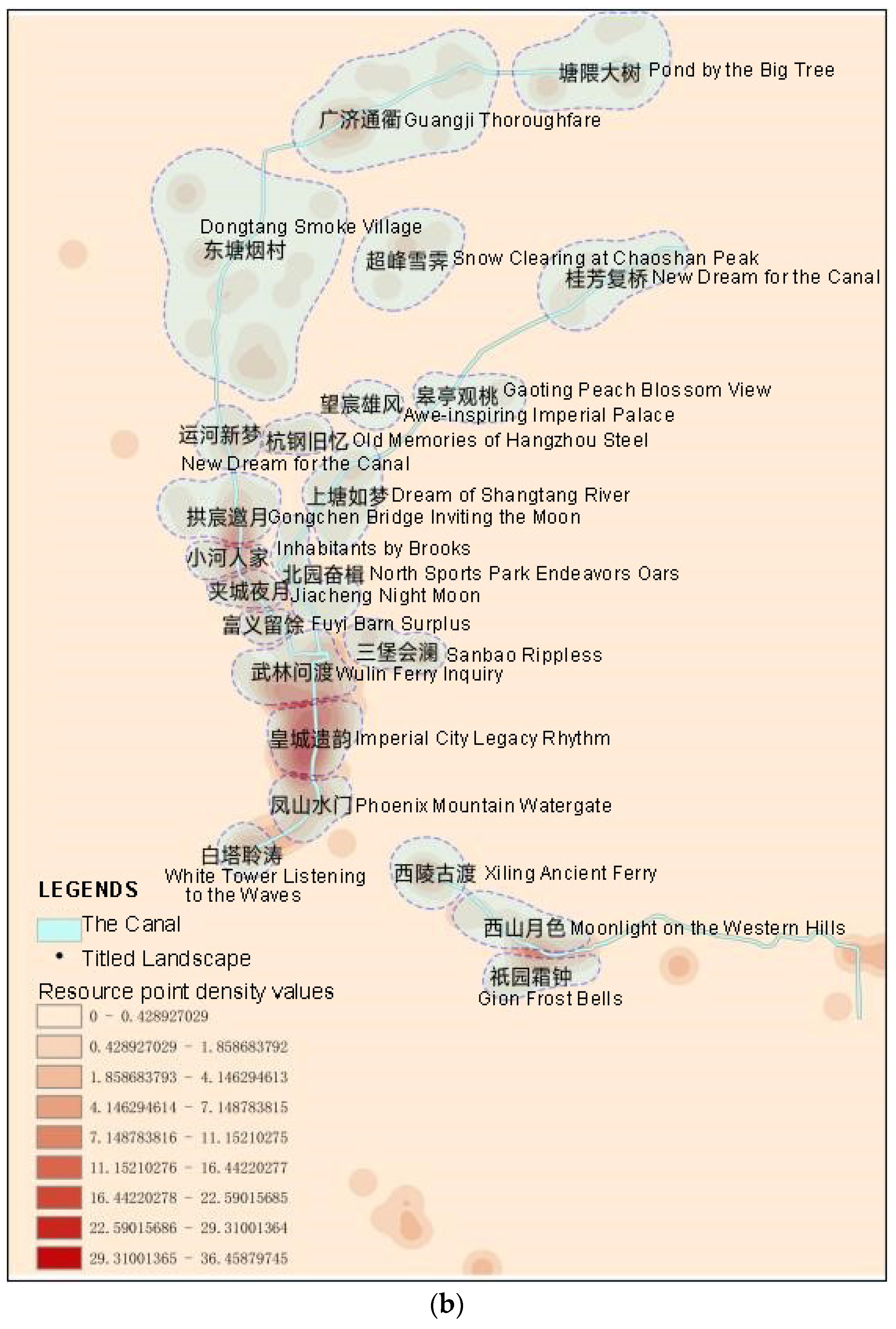
4.2.2. Nuclear Density Analysis

Considering the scope of the titled landscapes, the comfort level of walking accessibility, the degree of aggregation of resource points, and other factors, 1000 m was selected as the search radius for kernel density analysis. The calculated values were divided into nine levels using the natural breakpoint method (Figure 9b), with the darker color representing a higher density of resource point distribution. The 1000 m search radius can show the clustering relationships among resource points well, but the high-density hotspot area features are not obvious. However, the results of the secondary analysis of hotspot areas according to the 500 m search radius (Figure 9c) show that hotspot areas can show more obvious clustering and spatial clustering relationships. Therefore, in this paper, the kernel density analysis was carried out for non-hotspot areas using a search radius of 1000 m and for hotspot areas using a search radius of 500 m.
Figure 9. (a) Distribution of cultural landscape resource points of the canal. The line of red dots indicates the historic city center; the blue area indicates the West Lake (source: the authors); (b) kernel density analysis map for the 1000 m search radius; (c) map of the analysis of nuclear density hotspots with the 500 m search radius (source: the authors).
Land 13 01178 g009

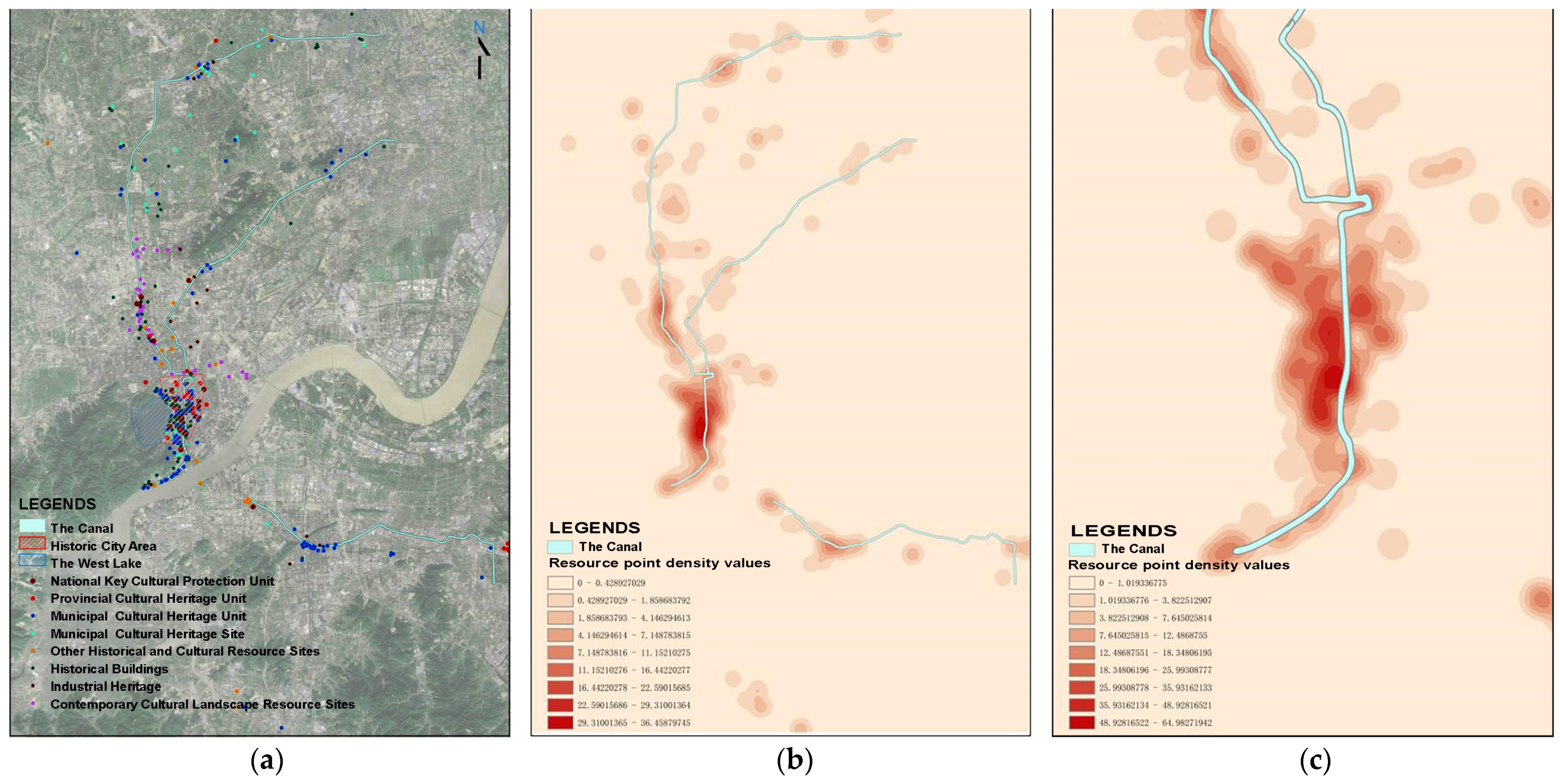
4.3. Spatial Location of Existing Titled Landscapes

The Hangzhou Grand Canal National Cultural Park Plan relies on ten skeleton rivers to form the planning structure, which is composed of “landscape clusters, riverbanks, ten core gardens, and a hundred scenic spots with special features” ([28], p13). Among them, “Hundreds of Scenic Features” refers to a number of characteristic resource spots with outstanding cultural themes and clustering of cultural resources, such as Gongchen Bridge, Dadou Road, and Xiangji Temple. Together, they constitute the Hangzhou Grand Canal National Cultural Park in five sections: Hangzhou Tang (south section), Hangzhou Tang (north section), Shangtang River, Zhedong Canal, Zhonghe River, and Longshan River (see Figure 1) (Appendix A, Table A1).
The titled landscapes of the Hangzhou Tang south section are based on the [Ming] Eight Scenes of Hushu, [Yuan] Qiantang Ten Scenes, Tangqi Ten Scenes, and Ten Scenes of the New Canal (voted on by citizens and experts in 2013) [69]. Hangzhou Tang is just one section of the Hangzhou Canal, and it has a number of currently recognized titled landscapes. With well over 200 inscribed landscapes in all the Hangzhou canals that have ever existed, it is difficult to keep track of them all.
The titled landscapes of Hangzhou Tang (northern section) are based on the 16 Scenes of Qixi [in the Qing Dynasty], the 10 Scenes of Bolu, and the 10 Scenes of the New Canal (selected by citizens and experts in 2013) [69], as well as the cultural landscapes shaped in the new era, which constitute the “Titled Landscape of Hangzhou Tang North”.
The Shangtang River section includes the Shangtang River Linping section of the “New East Lake Ten Scenic Spots” and the Gongshu uptown section of the “New Shangtang Eight Scenic Spots”.
The titled landscape of the Zhonghe and Longshan Rivers was constructed based on the [Qing] West Lake 18 Scenes, the new West Lake 10 Scenes (from 1984), the third round of the West Lake 10 Scenes voting (2007) [70], as well as the cultural landscape of the new era. They constitute the Zhonghe and Longshan Rivers titled landscape.
In the eastern section of the Zhejiang Canal, there are several versions of the historical titled landscape system from the Ming and Qing Dynasties. According to the principles of the preservation of landscape composition and the feasibility of restoration, and in combination with newly created landscapes at important nodes, the Xiaoshan Eight Scenes evolved to the “Xiaoshan New Eight Scenes”.
All of the above titled landscapes were localized in ArcMap10.8, as shown in Figure 11a. It was found that the remains of some of the titled landscapes have now disappeared, such as the Ten Scenes of Linping East Lake. Linping Lake is a sea trail lake, and is also called “East Lake” because it is located in the eastern part of West Lake in Hangzhou. From the Tang Dynasty, Zhang Hu’s poem “Passing through Linping Lake” reads as follows: “The mountain threshold is just a lotus leaf islet, and the water carcass is newly constructed with rice planting beds” [71]. Apparently, in the Tang Dynasty, Linping Lake’s water rose up to the bottom of Linping Mountain [72] (figures cannot be found). After the lake receded to the south in the Song Dynasty, it came to have an area of more than three thousand acres, with fascinating scenery. Toward the end of the Ming and early Qing dynasties, Linping Lake retreated to five miles east of the town (Figure 10a). In the late Qing Dynasty, Linping Town was developed between Linping Hill, Ding Hill, and Linping Lake (Figure 10b). In the early Republic of China, the silt intensified, leaving only a swamp, and scattered ponds developed. After many years of filling ponds and building fields, Linping Lake eventually became an agricultural field (Figure 10c). The titled landscapes, such as Dinghu Play Moon (鼎湖戏月) and Lotus Island Panboat (莲洲泛舟), eventually disappeared naturally along with the disappearance of the lake. To this day, only Bridge Pier at Dawn (桥墩拂晓) is preserved among all the Linping ancient scenery. Bridge Pier at Dawn (桥墩拂晓) was also known as Osmanthus Fragrance by Ancient Bridge (桂芳复桥).
The final delineation of the titled landscape comprising the 24 selected clusters, as shown in Figure 11b. In order from north to south, they are named as follows: Pond by the Big Tree (塘隈大树), Guangji Thoroughfare (广济通衢), Dongtang Smoke Village (东塘烟村), Snow Clearing at Chaoshan Peak (超峰雪霁), Osmanthus Fragrance by Ancient Bridge (桂芳复桥), Awe-inspiring Imperial Palace (望宸雄风), Gaoting Peach Blossom View (皋亭观桃), New Dream for the Canal (运河新梦), Old Memory of Hangzhou Steel Factory (杭钢旧忆), Gongchen Bridge Inviting the Moon (拱宸邀月), Inhabitants by Brooks (小河人家), Jiacheng Night Moon (夹城夜月), Dream of Shangtang River (上塘如梦), North Sports Park Endeavors Oars (北园奋楫), Sanbao Ripples (三堡会澜), Wulin Ferry Inquiry (武林问渡), Imperial City Legacy Rhythm (皇城遗韵), Phoenix Mountain Watergate (凤山水门), White Pagoda Ridge Waves (白塔岭涛), Xiling Ancient Ferry (西陵古渡), Moonlight on the Western Hills (西山月色), and Gion Frost Bell (祇园霜钟).

5. Assessment Results: Coupling of the Conservation and Utilization Values

5.1. Evaluation Results of the Conservation Value: Refinement of the TCS

After selecting 24 clustered titles based on the results of kernel density analysis and the selected titled landscapes of the Hangzhou Grand Canal National Cultural Park Plan, the 24 titled landscapes were quantitatively scored and ranked according to the three aspects of historical value, cultural value, and spiritual value; according to Equation (1), the top ten were identified as the TCS (Appendix A, Table A2).They are Wulin Ferry Inquiry (武林问渡), Phoenix Mountain Watergate (凤山水门), Imperial City Legacy Rhythm (皇城遗韵), Gongchen Bridge Inviting the Moon (拱宸邀月), Jiacheng Night Moon (夹城夜月), Guangji Thoroughfare (广济通衢), Fuyi Barn Surplus (富义留馀), Qixi Night Mooring (栖溪夜泊), Xiling Ancient Ferry (西陵古渡), and North Sports Park Endeavors Oars (北园奋楫) (Figure 12).

5.2. Assessment Results of the Utilization Value

After we selected the TCS, we conducted detailed evaluations and the organization of the conservation and developmental indicators for each titled landscape. In the initial screening of the TCS, values were assigned to the “conservation” indices. Subsequently, the “developmental” indices were evaluated and ranked based on the current situational assessment (Appendix A, Table A3).

5.3. Comprehensive Assessment Results of the Conservation and Utilization Values

By normalizing the scores of the conservation and developmental indicators and then calculating the total score, the current assessment results of the TCS could be obtained, as shown in Appendix A, Table A4.
According to the results, titled landscapes with a total score exceeding 1.00, such as the Imperial City Legacy Rhythm (皇城遗韵), Wulin Ferry Inquiry (武林问渡), Gongchen Bridge Inviting the Moon (拱宸邀月), and Guangji Thoroughfare (广济通衢) clusters, exhibited a high level of resource abundance and satisfaction of landscape needs. These clusters possess rich historical, cultural, and spiritual resources and are capable of utilizing and revitalizing these resources effectively to meet the needs of residents, tourists, and urban development.
Conversely, titled landscapes with a total score below 1.00, such as the North Sports Park Endeavors Oars (北园奋楫), represent modern cultural landscapes with lower levels of resource supply. Compared to the traditional titled cultural landscapes, this category still has significant room for improvement in satisfying landscape needs.
Furthermore, there are certain titled landscapes, such as Imperial City Legacy Rhythm (皇城遗韵), Phoenix Mountain Watergate (凤山水门), Jiacheng Night Moon (夹城夜月), and Osmanthus Fragrance by Ancient Bridge (桂芳复桥), where the scores of conservation indicators exceed those of development indicators. This suggests that these clusters possess historical, cultural, and spiritual resources but have not fully utilized them for revitalization and development. In particular, the Phoenix Mountain Watergate (凤山水门), Jiacheng Night Moon (夹城夜月), and Osmanthus Fragrance by Ancient Bridge (桂芳复桥) clusters exhibit significantly lower development indicator scores compared to other titled landscapes, indicating a need for focused efforts to enhance and develop these cultural landscapes.

5.4. Integrated Planning Propositions Based on the Assessment Results

According to the literature on field landscapes, those with development potential should be utilized thoughtfully for their protection. Conversely, those without development potential but with high conservation value should be safeguarded through standard procedures for cultural monuments, supported by public subsidies [75]. Similarly, based on the evaluation results presented in Appendix A, Table A4, the TCS are categorized into three groups: titled landscapes with a total score exceeding 1.00; titled landscapes with a total score below 1.00, where the score of conservation indicators is greater than the score of development indicators; titled landscapes with a total score below 1.00, where the score of conservation indicators is less than the score of development indicators (Figure 13). For each category, targeted landscape imagery construction strategy suggestions are provided to address specific needs and challenges.

5.4.1. Sustained Development and Fine-Tuning of Strategies

The titled landscapes with a total score of more than 1.00 include Imperial City Legacy Rhythm (皇城遗韵), Wulin Ferry Inquiry (武林问渡), Gongchen Inviting the Moon (拱宸邀月) and Guangji Thoroughfare (广济通衢). These titled landscapes are more prominent than other titled landscapes in terms of historical, cultural, and spiritual values, have clear cultural themes and representativeness, and have a higher degree of fulfillment in terms of landscape needs, education and publicity, and public services. These kinds of titled landscapes need to maintain their existing advantages and enrich and develop their own characteristics, but they also need to perform some enhancement of their connotations and themes, continuing to focus on the Grand Canal, to become the spiritual and cultural carriers of the canal. For example, the Imperial City Legacy Rhythm (皇城遗韵) needs to further incorporate the Middle River into the Southern Song Dynasty Imperial City town planning, renew the vitality and vitality of the Middle River, and promote the characteristics of the Song Dynasty in an organic combination with the canal, to broaden the cultural platform of the canal. Wulin Ferry Inquiry (武林问渡), on the other hand, needs to continue to deepen the connections between the Wulinmen Pier, the surrounding green spaces, commercial facilities, and the canal, create canal-specific activities, etc., and in this way, it can continue to broaden the content of cultural tourism related to the canal.

5.4.2. Potential Revitalization

Titled landscapes with a total score of less than 1.00 and a conservation indicator score greater than the development indicator score include Phoenix Mountain Watergate (凤山水门), Jiacheng Night Moon (夹城夜月), and Osmanthus Fragrance by Ancient Bridge (桂芳复桥). This kind of title has a high score in terms of the conservation value of the cultural landscape, and also has a strong development potential of its own. For example, Phoenix Mountain Watergate (凤山水门), as the only remaining watergate site in Hangzhou, has a large number of resource points within the cluster, with high historical value and spiritual value; Jiacheng Night Moon (夹城夜月), as the first of the eight scenic spots in Hushu, has high spiritual value; and Osmanthus Fragrance by Ancient Bridge (桂芳复桥), as the only remaining landscape site in Linping, has high historical value and cultural value. However, these kind of titles, for various reasons, have not given full play to their own resource advantages, which is especially true for the clustering performances of Jiacheng Night Moon (夹城夜月) and Osmanthus Fragrance by Ancient Bridge (桂芳复桥).
The theme of the Jiacheng Night Moon (夹城夜月) cluster is city life, but with the development of the city, the cultural attributes have gradually weakened, and the original atmosphere of a water town has been replaced by residential buildings. It has recently been converted to a park, but it is also far away from and weakly connected with the other restored parks of the “Eight Scenes of Hushu”, so it scores high in the conservation indicators, but low in the development indicators. The park is also far away and weakly connected with other “Eight Views” restoration parks. If the “Eight Scenes of Hushu” areas within the cluster of the Jiacheng Night Moon can be linked by the Grand Canal, and the cultural and commercial functions of the Cultural Park of the Jiacheng Night Moon (夹城夜月) can be expanded, then the “Eight Scenes of Hushu” and the canal culture can aid in each other’s successes and revitalize their significance.
The Osmanthus Fragrance by Ancient Bridge (桂芳复桥) cluster mainly represents the cultural landscape of the Linping area. Because of the disappearance of the East Lake, Linping’s “Ten Scenes of the East Lake” has perished for the most part, and other titled landscapes have also gradually become difficult to find over time. Osmanthus Fragrance by Ancient Bridge (桂芳复桥) has the highest value for the conservation of the cultural heritage of Linping, and has assumed the task of being the center of this landscape cluster, but the Guifang Bridge region has traditionally been productive and is in high demand. Additionally, the area around the Guifang Bridge has always been in high demand for commercial production and residence, and residential buildings have been built near the river. This does not provide much space for landscape construction and public service facilities, so its landscape demand indicator score is the lowest. In order to revitalize this area, it will be necessary to link the cultural landscapes of the whole of Linping and the “Ten Scenic Spots of Donghu Lake”, and to strengthen cultural exchanges between various cultural landscapes in Linping along the Shangtang River.

5.4.3. Activation of the Cultural Lineage

Titled landscapes with a total score of less than 1.00 and a conservation index score that is less than the development index score include Fuyi Barn Surplus (富义留馀), North Sports Park Endeavors Oars (北园奋楫), and Xiling Ancient Ferry (西陵古渡). The advantage of these kinds of titled landscapes is that although the resource points within the cluster are not rich enough, there are not enough non-heritage projects, and there are no poem and painting opportunities left due to the sites’ over-functionality, the current utilization is better, and the usability, public service, and economic creativity are relatively strong. If these advantages continue to be developed and tapped into, they will become strong representatives of the cultural landscape along the canals.
However, the disadvantage of these kinds of titled landscapes are that the scores of the conservation index are too low, and the degrees of excavation of their own history and culture are not enough. Taking Fuyi Barn Surplus (富义留馀) and North Sports Park Endeavors Oars (北园奋楫) as two typical examples, although the resource points within the Fuyi Barn Surplus (富义留馀) cluster are not rich enough, the central cultural landscape of the Fuyi Barn itself has strong historical and cultural attributes of the canal. Regarding the revitalization and utilization of the Fuyi Barn, it is only used as an art exhibition space, and its cultural attributes have not been activated. If the historical and cultural attributes inside and outside the Fuyi Barn and the surrounding parks are strengthened, the landscape along the canal is fully utilized, and water activities such as passenger terminals are developed, then Fuyi can be activated in all aspects. The internal resources of the North Sports Park Endeavors Oars (北园奋楫) cluster are also not rich enough, but its central cultural landscape, Chengbei Sports Park, is the only modern landscape in the “Ten Canal Scenes”. Additionally, the plasticity and inclusiveness of modern landscapes are far greater than those of other landscapes, and if you want to enhance the cultural attributes of this section of the titled landscape, you have to strengthen the connection between the Chengbei Sports Park and the canal and make full use of the artificial landscape connected with the canal in the park. For example, the proper renewal of old industrial buildings and planning and design of landscapes is needed to activate the cultural connections of these areas.

5.4.4. Integration and Branding

Throughout the entire heritage section of the canal, the TCS are located along every major river, linking the entire canal together. In the south end of Hangzhou Tang and the middle section of the river, which are densely populated with titled landscapes, the existing canal tour lines can be utilized, and cruise ships and water buses can be used to connect the titled landscapes with each other. The more distant Guangji Thoroughfare (广济通衢), Osmanthus Fragrance by Ancient Bridge (桂芳复桥), and Xiling Ancient Ferry (西陵古渡) also need special tour lines to connect them with the central area, so as to strengthen the overall nature of the canal, and to give the residents and tourists a holistic perception and impression of the entire heritage section of the canal. In addition, a variety of water culture and art activities should be organized, using canal-related titles, poems, paintings, and other art works as themes to strengthen the intangible cultural and artistic imagery of the canal. On the other hand, the TCS should have landscape imagery that can highlight the characteristics of the canal and echo the titles, which can be restored so that residents and tourists can have a holistic perception and impression of the entire canal. The titles can be restored, and a punch-card point can be set up. Digital means can also be used to create a scene that includes the ancients across time and space to make the canal culture and the image of the canal more deeply rooted in people’s hearts.

6. Discussion

6.1. Review of the Aim for the TCS

To elevate the TCS as a hallmark of Hangzhou akin to the renowned “Ten Scenes of West Lake” and to safeguard and rejuvenate the cultural landscape resources along the Hangzhou section, it is imperative to carefully select those scenes that are in alignment with the canal’s resources. This will ensure that cultural facility development and recreation efforts are in harmony with the canal’s cultural significance. This paper demonstrates a localized canal development model. Most of the current studies compare the potential for heritage utilization along the Grand Canal at a “cross-provincial scale” [76]. This research highlights the need for a tailored approach to the protection and utilization of the Beijing–Hangzhou Grand Canal, particularly the Hangzhou section. It identifies the Hangzhou canal development model as a characteristic case study and provides valuable insights for the planning and construction of the National Cultural Park of the Grand Canal. The technical system for dividing the basic units of the cultural landscape demonstrates systematic thinking and the integration of research methods. By combining bottom-up resource investigation with top-down strategic planning, the study offers a comprehensive approach to understanding and addressing cultural landscape challenges. Suggestions for future decision-making and land management actions are systemized, as shown in Figure 14.
Theoretically, this paper improves the mechanism of measuring and adjusting the value of cultural landscapes based on layer accumulation theory and multidimensional value attributes. Canal heritage includes different types of heritage, such as “site-type” and “in-use” heritage, but the current concept of the holistic protection of the canal’s heritage still remains at the stage of protecting the “site-type” Grand Canal heritage, ignoring the “in-use” heritage. In addition, according to the “Stratification Theory”, the cultural landscape of the canal should not only include the tangible and intangible heritage of the canal, but should also include the new architecture and culture of the present generation, such as the Grand Canal Museum and the Museum of Knives, Scissors and Swords, as well as sports and ecological spaces, such as the Grand Canal Asian Games Park, etc. Most of the current studies only focus on the “historical heritage” along the Grand Canal, but ignore the contemporary cultural landscape [77]. To safeguard cultural landscapes and living traditions, decisions made by cultural heritage protection authorities must be informed by thorough scientific research into cultural traditions and with consideration for the well-being of the tradition’s current practitioners [78]. This paper considers the contemporary cultural landscape as a whole. It includes contemporary cultural landscapes in the category of titled landscapes, extends traditional poetry and painting to modern art and contemporary culture, and updates the method of preserving and utilizing the Grand Canal’s cultural landscapes, providing a localized perspective. For example, North Sports Park Endeavors Oars (北园奋楫) and Old Memory of Hangzhou Steel Factory (杭钢旧忆) are completely contemporary landscapes that were added in recent years. They display the modern urban image of a sports symposium and a steel factory, which are crucial supplements to the traditional landscapes.

6.2. Contemporary Drawings of the TCS

While the titled landscapes of West Lake possess iconic classical appeal, the portrayal of the canal lacks a similar status. Contemporary Chinese artists have depicted the natural scenery and historical landscapes of the Beijing–Hangzhou Grand Canal from a panoramic viewpoint. However, in the Hangzhou section alone, the imagery of the cultural landscape of the canal is more embodied as a humanistic landscape rather than a natural landscape. Therefore, the TCS of the Hangzhou section need to be more reflective of urban and humanistic characteristics. Contemporary artists’ creations of the TCS show a diversity of styles; complementing traditional Chinese landscape paintings, modern illustration styles have also appeared [79] that are often more easily accepted by young people.

6.3. Historical Urban Landscapes (HUL) Approach and Conzen’s Urban Morphological Analysis

While exceptionalism may be effective in tailored studies with local objectives, it is not a viable approach for a global investigation into the conservation of cultural landscape heritage. Scientific theories must be applicable across contexts to advance theoretical studies and the spatial shaping of urban cultural heritage. As a canal city, Hangzhou has its special characteristics. However, for the protection of cultural landscape heritage, the spatial creation method proposed in this paper has a certain general significance for promotion. Its generalizability is reflected in the synergy of the research framework with LCA, HUL, and other research frameworks. The landscape character assessment (LCA) in this research adopts zoning approach based on landscape units. This work is comparable with the aims of the historical urban landscapes (HUL) approach that originated in Conzen’s Urban Morphological Analysis. Conzen’s research on the urban form based on ownership parcels encompasses an exploration spanning from the local to the whole, as well as an examination of the historical evolution process [80]. The “local to whole” research approach underscores the idea that the intricate whole is composed of simpler elements at various levels. Simultaneously, the emphasis on the historical evolution process involves scrutinizing the development of objective phenomena over time. By extracting historical samples and establishing evolutionary sequences, Conzen identified the early form of title parcel division as a crucial influence on subsequent mergers and re-divisions of title parcels [81]. Building on the study of property parcels, the British School of Urban Morphology subsequently tested and extensively explored the potential applications of these concepts in planning practice [82]. In the HUL approach, the sub-regions constituting the urban historic landscape system are called “urban historic landscape units” (HUL units), based on the principles of internal relative homogeneity and external relative heterogeneity. Morphological regions are made up of different levels of morphological regional units, showing the complex historical geospatial structure of urban morphology [83]. Conzen’s morphological area division for the British town Ludlow spanned five levels, allowing for a comprehensive recognition of historical culture and precise protection [84]. By employing spatial zoning, temporal phasing, and methodological separation, a classification and grading system was established, capable of fine management. This system contributed to the continuous development of the urban fabric through metabolism, achieving a balance between the protection of individual property rights and interests and development. This, in turn, realized the healthy resilience of the city, helping it maintain its enduring vitality and dynamism.

6.4. Shortcomings of Reductionist Methods in Cultural Landscape Heritage Conservation

It should be noted that the indicators in this paper are quantitative in nature and are based on the reductionist view of reality. In a reductionist view, one aspect is given excessive emphasis, even to the detriment of other parts. Approaches based on reductionism are unable to handle all the elements and components of the cultural landscape system, both deterministic and nominal ones, demonstrating ignorance and imbalance. They may also be misleading, leading to an unbalanced path in the future developments of cultural heritage conservation [85]. Furthermore, social data are crucial components in the assessment of cultural values of the landscape. In this paper, people’s perceptions are represented as spiritual values, which are related to art works and intangible heritage. In future studies, the reductionist approach will be integrated with the holistic approach by adaptive adjustment and debugging of multilevel values. Questionnaires given to residents and experts will also be conducted to produce more comprehensive suggestions.

7. Conclusions

The development of the Grand Canal cultural belt stands as a critical strategic priority within China’s national cultural agenda. Provinces and cities along its route, including Hangzhou, are actively engaged in its realization. Despite the decline in the canal’s transportation role, there remains significant potential for the cultivation of cultural functions. It is essential to ensure deep coordination between urban character formation, construction, and development efforts, all while addressing the imperative for excavating the cultural landscape of the Grand Canal. This paper, through evaluating the cultural landscape elements of the canal in terms of history, space, art, and spirit, extracts the TCS in line with the local characteristics. Leveraging a value assessment framework, tailored recommendations are proposed to address both the landscape and socio-economic aspects at nodal points, considering variations in scores between conservation and developmental indicators. The recommendations include “sustainable development and strategic fine-tuning” of titled landscapes with overall high scores and “potential revitalizing” for landscapes with relatively greater potential, particularly those with conservation indicators outscoring developmental ones. Furthermore, the paper proposes strategic interventions for “context activation” in areas lacking sufficient historical and cultural connotations, notably those with conservation indicators scoring lower than developmental indicators. Lastly, the paper outlines a comprehensive strategic approach for the “Ten Canal Scenes”, aiming to synthesize and enhance the collective impact of these landscapes. The overarching objective is to cultivate memorable urban cultural landmarks, fostering a harmonious alignment between the demands of the canal’s cultural landscape preservation and Hangzhou’s urban development imperatives.
This paper emphasizes Hangzhou’s regional characteristics through a systematic approach to landscape division and innovations in spatial planning methodology. First, this study focuses on the “city and river together” aspect of Hangzhou’s cultural landscape, particularly along the Grand Canal. Unlike other sections of the canal that traverse suburban or rural areas, Hangzhou’s section passes through the city center. By analyzing the cultural landscape from an urban meso scale, the study offers targeted recommendations with strong local relevance. Second, the technical system employed for dividing basic units of the cultural landscape demonstrates systematic thinking and integrates sections and blocks. Utilizing both reductionist and comprehensive methods, the study conducts bottom-up resource investigation while also employing system theory to propose top-down strategies and construction modes. This dual approach maximizes the effectiveness of the research methods. Third, this paper innovates by integrating the synergy between the protection and utilization of cultural landscapes. By leveraging the imagery of the TCS and combining it with immersive cultural and tourism experiences, the study explores adaptive technical tools and service technology innovations. These innovations provide a framework for the integration of cultural and tourism development, offering practical solutions for the protection, utilization, monitoring, and management of the Grand Canal’s cultural landscape.
Despite its contributions, this paper has several limitations that warrant consideration. For instance, the scale of unit division requires further refinement, and the weights and measurement methods need to be better adapted. The framework of the Ten Scenes of West Lake is comprehensive, encompassing various sensory experiences, seasonal variations, and meteorological factors. However, the refinement of the Ten Canal Scenes has not yet taken into account these factors in a coordinated manner. Additionally, with the opening of the second corridor, there is potential for additional scenic spots to be included, such as Eight Treasures Canal Lock. Moreover, as the second-channel navigation grade is higher, the surrounding countryside landscape could potentially accommodate ten or even twelve views, expanding the scope of the study. Nevertheless, the TCS are not eternal. Instead, the results evaluated in different historical junctures will be, and should be, subject to change. Thus, the process of selecting the TCS can be perpetually revisited and refined, ensuring its relevance and resonance endure across successive epochs.
The suggested future research directions are mainly targeted at refining the spatial study and digital regeneration technologies. For example, the spatial stratification and zoning of the cultural landscape along the Grand Canal should be studied, with a focus on more refined unit divisions, weight adjustments, and model summarization, which could enhance our understanding of the protection, inheritance, and use of canal heritage. The use of digital regeneration technology for cultural heritage preservation should be explored, particularly with a focus on immersive cultural tourism experiences based on the TCS. In this regard, this study could provide a basis for adaptive technological tools facilitating the monitoring and management of the Grand Canal’s cultural landscape.

Author Contributions

Conceptualization, W.D.; Validation, W.H.; Formal analysis, C.Z.; Resources, J.W; Writing—original draft, C.Z.; Writing—review and editing, W.D.; Project administration, J.W.; Funding acquisition, W.D. All authors have read and agreed to the published version of the manuscript.

Funding

This research was funded by the Exploratory Program of Zhejiang Provincial Natural Science Foundation, China, grant number [LY24E080007].

Institutional Review Board Statement

Not applicable.

Data Availability Statement

The data presented in this study are available on request from the corresponding author. The data are not publicly available due to privacy restrictions.

Acknowledgments

This study was also funded by the “Zhejiang University-Hangzhou Canal Group Joint Research Center for Urban Area Development” project, and we are grateful to the Hangzhou Canal Comprehensive Conservation, Development and Construction Group Company Limited (now Hangzhou Commerce, Trade and Tourism Group Co., Ltd.) for their support at all stages of the project.

Conflicts of Interest

The authors declare no conflicts of interest.

Appendix A

Appendix A.1. Average Nearest Neighbor (ANN) Analysis

The ANN is calculated by dividing the observed average distance by the desired average distance. The average nearest neighbor ratio is calculated as
A N N = D ¯ o D ¯ E
where D ¯ o is the average of the distances between the measured elements and their nearest neighboring quality centers:
D ¯ o = Σ i = 1 n d i n
D ¯ E is the elemental randomly distributed mean distance:
D ¯ E = 0.5 n A
In the above equation, d i is the distance of element i from its nearest neighboring element, n is the number of elements in the region, and A is the area of the envelope of all elements. If the ANN is greater than 1, it is a random distribution; if the ANN is less than 1, it is a clustered distribution.
Table A1. The titled landscape in each sub-section of Hangzhou Grand Canal National Cultural Park (source: the author).
SectionNo.Chinese TitleTitle of the Cultural LandscapeSource
Hangzhou Tang (northern section)1西浦斜阳Slanting Sunset of Xipu 16 Scenes of Qixi [from Qing Dynasty], 10 Scenes of Bolu, 10 Scenes of the New Canal (2013) [69], new cultural landscapes
2长桥月色Moonlight on the Changqiao Bridge
3超峰雪霁Snow Clearing at Chaoshan Peak
4翠河秋色Autumn Color of the Cuihe River
5永明晚钟Evening Bell of Yongming
6北塘夜市Night Market of Beitang
7广济通衢Guangji Thoroughfare
8丁河红妆Red Makeup of Ding River
9五杭古集Ancient Gathering of Wuhang
10前溪风芦Wind of the Qianxi
Hangzhou Tang (southern section) 1夹城夜月Jiacheng Night Moon [Ming] Eight Scenes of Hushu, [Yuan] Qiantang Ten Scenes, Tangqi Ten Scenes, Ten Scenes of the New Canal (2013) [69]
2陡门春涨Spring Rise of Steep Gate
3江桥暮雨Twilight Rain of River Bridge
4西山晚翠Evening Green of Xishan
5花圃啼莺Crowing Warblers in Flower Garden
6皋亭积雪Snow of Gao Ting
7白荡烟村Smoky Village of White Reeds
8半道春红Spring Red of Halfway
9北关夜市Night Market of North Juncture
10香积梵音Vanishing Sound of Xiangji Temple
11小河人家Inhabitants by Brooks
12拱宸邀月Gongchen Bridge Inviting the Moon
13运河新梦New Dream for the Canal
14义桥老街Old Street of Yixiao
Shangtang River 1桂芳复桥Osmanthus Fragrance by Ancient BridgeNew East Lake Ten Scenic Spots
2安平晚钟Anping Evening Bells
3断山残雪Broken Mountain Snow
4鼎湖玩月Dinghu Playing with the Moon
5藕洲泛艇Lotus Roots Island Panboat
6隆兴望月Longxing Looking at the Moon
7佛日禅踪Buddha’s Zen Trail
8段浜观梅Duanbang Guanmei
9枫林夕照Maple Grove Sunset
10桃堰渔火Peach Weir Fisherman’s Fire
11皋亭观桃Gaoting Peach Blossom View New Shangtang Eight Scenic Spots
12望宸雄风Awe-inspiring Imperial Palace
13上塘如梦Dream of Shangtang River
14北园奋楫North Sports Park Endeavors Oars
15双流抱亭Double Stream Beside Pavilion
16丁兰孝道Dinglan Filial Piety
17纤塘依君Xiantang by Your Side
18古松老桥Old Bridge by Ancient Pines
Zhonghe and Longshan Rivers1吴山天风Winds in the Sky of Wushan [Qing] West Lake 18 Scenes, New West Lake 10 Scenes (from 1984), the 3rd round of the West Lake 10 Scenes voting in 2007 [70]
2玉皇飞云Yuhuang Flying Clouds
3万松书缘Wansong Shuyuan
4凤岭松涛Phoenix Ridge Pines
5小营红巷Red Lane New cultural landscape
6夜坊清河Night Square Qinghe
7凤山水门Phoenix Mountain Watergate
8皇城遗韵Imperial City Legacy Rhythm
9八卦农作Bagua Farming
10白塔临江White Pagoda by the River
East Section of Zhejiang Canal1菊山秋霁Chrysanthemum Hill Autumn ClearingXiaoshan Eight Scenes, Xiaoshan New Eight Scenes
2西陵古渡Xiling Ancient Ferry
3西山月色Moonlight on the Western Hills
4北岭烟光Beiling Smoke
5祈园霜钟Praying for the Garden Frost Bells
6樵楼晓角Dawn Corner of Woodcutter’s House
7杭坞龙湫Hangzhou Wall Dragon Marsh
8东岳揽胜East Mountain Embracing the Wonderful Scenery Two scenes have been remodeled
9梦笔亭驿Dream Brush Pavilion Inn
Table A2. Evaluation Results of the Conservation Value (Source: the authors).
Titled LandscapesChinese TitleHistoric Value (C.1.)Cultural Value (C.2.)Spiritual Value (C.3.)Total
C.1.1.C.1.2.C.1.3.C.2.1.C.2.2.C.2.3.C.3.1.C.3.2.
lit. Wulin Ferry Inquiry武林问渡0.99 1.00 1.00 1.00 0.40 0.40 0.00 1.00 5.79
lit. Phoenix Mountain Watergate凤山水门1.00 0.97 1.00 1.00 0.20 0.07 0.00 1.00 5.24
lit. Imperial City Legacy Rhythm皇城遗韵0.59 0.51 1.00 1.00 1.00 1.00 0.00 0.00 5.10
lit. Gongchen Bridge Inviting the Moon拱宸邀月0.15 0.14 1.00 1.00 0.40 0.27 1.00 1.00 4.96
lit. Jiacheng Night Moon夹城夜月0.16 0.12 1.00 1.00 0.20 0.07 1.00 1.00 4.55
lit. Guangji Thoroughfare广济通衢0.15 0.14 1.00 0.50 0.20 0.07 1.00 1.00 4.05
lit. Fuyi Barn Surplus富义留馀0.09 0.06 1.00 1.00 0.20 0.13 0.00 1.00 3.48
lit. Qixi Night Mooring栖溪夜泊0.06 0.07 0.33 0.50 0.20 0.20 1.00 1.00 3.36
lit. Xiling Ancient Ferry西陵古渡0.06 0.04 1.00 0.50 0.40 0.13 1.00 0.00 3.13
lit. North Sports Park Endeavors Oars北园奋楫0.04 0.03 0.67 1.00 0.20 0.13 0.00 1.00 3.06
lit. Broken Mountain Snow断山残雪0.05 0.06 1.00 0.50 0.20 0.07 1.00 0.00 2.87
lit. Inhabitants by Brooks小河人家0.15 0.10 1.00 1.00 0.40 0.13 0.00 0.00 2.78
lit. Gion Frost Bell祇园霜钟0.15 0.15 0.67 0.50 0.20 0.07 1.00 0.00 2.73
lit. Gaoting Peach Blossom View皋亭观桃0.02 0.02 0.67 0.50 0.20 0.07 1.00 0.00 2.48
lit. Pond by the Big Tree塘隈大树0.07 0.06 0.33 0.50 0.20 0.20 1.00 0.00 2.37
lit. Awe-inspiring Imperial Palace望宸雄风0.00 0.00 0.67 1.00 0.40 0.20 0.00 0.00 2.27
lit. Moonlight on the Western Hills西山月色0.12 0.11 0.67 0.00 0.00 0.00 1.00 0.00 1.90
lit. Dream of Shangtang River上塘如梦0.07 0.08 0.67 0.00 0.00 0.00 0.00 1.00 1.82
lit. White Tower Listening to the Waves白塔聆涛0.12 0.11 1.00 0.00 0.00 0.00 0.00 0.00 1.23
lit. Sanbao Ripples三堡会澜0.06 0.04 0.00 0.00 0.00 0.00 0.00 1.00 1.10
lit. Snow Clearing at Chaoshan Peak超峰雪霁0.04 0.05 0.00 0.00 0.00 0.00 1.00 0.00 1.08
lit. Dongtang Smoke Village东塘烟村0.24 0.23 0.33 0.00 0.00 0.00 0.00 0.00 0.81
lit. New Dream for the Canal运河新梦0.04 0.03 0.33 0.00 0.00 0.00 0.00 0.00 0.40
lit. Old Memory of Hangzhou Steel Factory杭钢旧忆0.02 0.02 0.33 0.00 0.00 0.00 0.00 0.00 0.38
Table A3. Assessment results of the utilization value for TCS (Source: the authors).
Titled LandscapeChinese TitleLandscape Value (D1)Social Value (D2)Economic Value (D3)Total
D.1.1.D.1.2.D.1.3.D.1.4.D.2.1.D.2.2.D.2.3.D.3.1.D.3.2.
lit. Gongchen Bridge Inviting the Moon拱宸邀月45554554542
lit. Guangji Thoroughfare广济通衢45554551539
lit. Wulin Ferry Inquiry武林问渡55533455338
lit. Imperial City Legacy Rhythm皇城遗韵15545531534
lit. North Sports Park Endeavors Oars北园奋楫53512453331
lit. Fuyi Barn Surplus富义留馀22544342228
lit. Xiling Ancient Ferry西陵古渡32554321328
lit. Phoenix Mountain Watergate凤山水门22543312325
lit. Jiacheng Night Moon夹城夜月32531242123
lit. Osmanthus Fragrance by Ancient Bridge桂芳复桥31521131118
Table A4. Integrated value assessment results of the TCS (Source: the authors).
Titled LandscapeChinese TitleConservation Indicator ScoreNormalized Score 1Developmental Indicator ScoreNormalized Score 2Normalized Total Score
Imperial City Legacy Rhythm皇城遗韵6.971.00340.671.67
lit. Wulin Ferry Inquiry武林问渡5.790.70380.831.53
lit. Gongchen Bridge Inviting the Moon拱宸邀月4.960.48421.001.48
Guangji Thoroughfare广济通衢4.750.43390.881.31
Phoenix Mountain Watergate凤山水门4.420.35250.290.64
Jiacheng Night Moon夹城夜月4.630.40230.210.61
Fuyi Barn Surplus富义留馀3.600.14280.420.56
North Sports Park Endeavors Oars北园奋楫3.060.00310.540.54
Xiling Ancient Ferry西陵古渡3.130.02280.420.44
lit. Osmanthus Fragrance by Ancient Bridge桂芳复桥3.910.22180.000.22

References

  1. Li, H.; Xiao, J. Analysis of the types of cultural landscapes and their constituent elements in China. Chin. Gard. 2009, 2, 90–94. [Google Scholar]
  2. Lin, H.; Rong, M.; Chen, X. Landscape culture and cultural landscape. Anhui Agric. Sci. 2012, 3, 1618–1620+1774. [Google Scholar]
  3. Değirmenci, T. The Contribution of Intangible Cultural Heritage to Outstanding Universal Value of UNESCO World Heritage Sites: An Analytical Evaluation on Cultural Landscapes. Ph.D. Thesis, Dokuz Eylul Universitesi, İzmir, Turkey, 2020. [Google Scholar]
  4. Saleh, M. Value Assessment of Cultural Landscape in Alckas Settlement, Southwestern Saudi Arabia. Ambio A J. Hum. Environ. 2009, 29, 60–66. [Google Scholar] [CrossRef]
  5. Wan, M.; Wang, Z.; Pan, Y. Research on the regional landscape characteristics of the Jianghan Plain based on the eight scenic systems of the lake and river network. Landsc. Archit. 2020, 27, 10–15. [Google Scholar]
  6. Blocker, B. Cultural Landscapes, Historic Preservation, and Cattle Ranches: A New Protocol for Documenting and Preserving Historic Working Cattle Ranches in Texas. Featuring a Case Study at the Dudley Brothers Ranch in Comanche. Texas Using TX-CLEVR (Texas Cultural Landscape Evaluation for Ranches). Ph.D. Thesis, The University of Texas at Arlington, Landscape Architecture, Arlington, TX, USA, 2021. [Google Scholar]
  7. Kıran, A.İ. Evaluation of Historical Orchards in the Istanbul Land Walls World Heritage Site within the Scope of Cultural Landscape. Master’s Thesis, Mimar Sinan Fine Arts University, Istanbul, Turkey, 2019. [Google Scholar]
  8. Hun, L.C.; Shin, H.-S. A Basic Study on the Establishment of Evaluation Items for the Resiliency of Planting Landscape in Hahoe and Yangdong of World Cultural Heritage. J. Korean Inst. Tradit. Landsc. Archit. 2018, 36, 21–29. [Google Scholar] [CrossRef]
  9. Ongyerth, G. Analysis and evaluation of the cultural landscape in city construction. Goals and methods of applied historical geography in the context of use of space and care of the landscape. Archaol. Nachrichtenblatt 2001, 6, 212–221. [Google Scholar]
  10. Gravis, I.; Nemeth, K.; Procter, J.N. The Role of Cultural and Indigenous Values in Geosite Evaluations on a Quaternary Monogenetic Volcanic Landscape at IhumAtao, Auckland Volcanic Field, New Zealand. Geoheritage 2017, 9, 373–393. [Google Scholar] [CrossRef]
  11. Golestani, N.; Khakzand, M.; Faizi, M. Evaluation of the quality of participatory landscape perception in neighborhoods of cultural landscape to achieve social sustainability. Aestimum 2022, 81, 71–91. [Google Scholar] [CrossRef]
  12. Petrova, E.G.; Mironov, Y.V.; Aoki, Y.; Matsushima, H.; Ebine, S.; Furuya, K.; Petrova, A.; Takayama, N.; Ueda, H. Comparing the visual perception and aesthetic evaluation of natural landscapes in Russia and Japan: Cultural and environmental factors. Prog. Earth Planet. Sci. 2015, 2, 6. [Google Scholar] [CrossRef]
  13. Zhao, Z. The New Concept of World Heritage Conservation—Cultural Landscape. Urban Plan. Newsl. 1995, 14, 12. [Google Scholar]
  14. Tang, M. The connotation of cultural landscape and its research progress. Prog. Geogr. Sci. 2000, 1, 70–79. [Google Scholar]
  15. Han, F. Exploring cultural landscapes in the forward march. Chin. Gard. 2012, 5, 5–9. [Google Scholar]
  16. Shan, J. From ‘cultural landscape’ to ‘cultural landscape heritage’ I. Southeast Cult. 2010, 2, 7–18. [Google Scholar]
  17. Shan, J. From ‘cultural landscape’ to ‘cultural landscape heritage’ II. Southeast Cult. 2010, 3, 7–12. [Google Scholar]
  18. Zhou, N.; Yu, K.; Huang, Z. Focusing on the New Trend of Heritage Conservation: Cultural Landscapes. Hum. Geogr. 2006, 21, 61–65. [Google Scholar]
  19. Cai, Q. Cultural Landscape Conservation Based on Territory. Ph.D. Thesis, Southeast University, Nanjing, China, 2006. [Google Scholar]
  20. Wang, Y.; Shi, X. Spatial Characteristics and Formation Mechanism of Traditional Regional Cultural Landscape. J. Tongji Univ. (Soc. Sci. Ed.) 2010, 21, 31–38. [Google Scholar]
  21. Zhang, H.; Wang, H.; Fu, X. Research on the evaluation of cultural landscape value of traditional villages in southern Anhui region: Taking the example of Xihe Ancient Town in Wuhu County. J. Hunan City Coll. (Nat. Sci. Ed.) 2021, 30, 37–42. [Google Scholar]
  22. Han, J.; Wang, Y. Implications of Cultural Landscape Value Perception for the Protection of Traditional Villages in China. Urban Archit. 2022, 19, 89–94. [Google Scholar]
  23. Wang, J. Spatial division of the Grand Canal ontology and the conservation and construction of ‘one axis and two sides’ of the ancient and modern canals. Mod. Urban Stud. 2021, 7, 2–6. [Google Scholar]
  24. Zhu, Y.; Wang, Y. Research on the influence of canals on the urban spatial structure of Beijing—another discussion on the protection and construction strategy of the canal culture belt. Urban Dev. Res. 2019, 26, 44–48. [Google Scholar]
  25. Liu, Q. Research on Linear Cultural Heritage Tourism Cooperation under the Vision of World Heritage: Taking the Beijing-Hangzhou Grand Canal as an Example; China Economic Press: Beijing, China, 2015. [Google Scholar]
  26. Zhang, F.; Yang, L.; Shi, Y.; Luo, S. A study on the spatial scope and level of recreation in the cultural belt of the Grand Canal. Reg. Res. Dev. 2019, 38, 80–84. [Google Scholar]
  27. Ren, S. Research on Waterfront Landscape of Hangzhou Main City Section of Beijing-Hangzhou Canal. Ph.D. Thesis, Zhejiang University, Hangzhou, China, 2012. [Google Scholar]
  28. Hangzhou Planning and Natural Resources Bureau; Hangzhou Urban Planning and Design Institute. Planning of Hangzhou Grand Canal National Cultural Park; Hangzhou Planning and Natural Resources Bureau, Hangzhou Urban Planning and Design Institute: Hangzhou, China, 2022. [Google Scholar]
  29. People’s Government of Zhejiang Province. General Rules for Land Space Control in the Core Monitoring Zone of the Grand Canal in Zhejiang Province. Zhejiang government office letter [2021] No. 9. February 22, 2021; People’s Government of Zhejiang Province: Hangzhou, China, 2021.
  30. Zhang, Y. Eight Views of Xiaoxiang; Shanghai Museum: Shanghai, China; Available online: https://auction.artron.net/paimai-art5173200238/ (accessed on 28 July 2024).
  31. Shang-Rui. Eight Views of Xiaoxiang in Early Qing Dynasty. Available online: https://amma.artron.net/observation_shownews.php?newid=1109730 (accessed on 28 July 2024).
  32. Zhu, J. The origin and flow of eight scenic spots. Beijing Political Consult. 1994, 8, 42. [Google Scholar]
  33. Lu, C.; Yin, Q. Name, Origin and Characteristics of “Eight Scenic Spots” and “Ten Scenic Spots”. Yichun Teach. Coll. J. 1997, 6, 73–76. [Google Scholar]
  34. Feng, M. Text, Image, and History: Multiple Conceptions of Time in the Song Painting Zhongxing Ruiyingtu. Fine Arts 2022, 12, 110–119. [Google Scholar]
  35. Ye, X. Album of Ten Scenes of West Lake; National Palace Museum: Taiwan, China, Painted between year 1253 and 1258.
  36. Lan, Y. Ten Scenes of West Lake. Available online: https://amma.artron.net/observation_shownews.php?newid=1109730 (accessed on 28 July 2024).
  37. Sun, Z. Imagery and Patterns—A Study of Landscape Centered on Ye Xiaoyan’s Album of Ten Scenes of West Lake. Fine Arts Des. 2023, 6, 041. [Google Scholar]
  38. Tanaka, M.; Tobikin, Y.; Aoki, Y. On the distribution of the eight scenic spots in Japan. Res. Randus 1999, 63, 246–248. (In Japanese) [Google Scholar]
  39. Pan, Y.; Yu, S.; Wan, M. Research Progress of Pan-East Asian Area Eight- Scenes Culture. Chin. Landsc. Archit. 2022, 38, 121–126. [Google Scholar]
  40. Scarre, C. The Seven Wonders of the Ancient World. Class. Bull. 2001, 80, 125–127. [Google Scholar]
  41. Ali, M.A.M.; Kotb, A.A.; Elsherif, A.; Hisham, R.; Osama, M. Environmental’s Design Role in the Reviving and Preserving of Architectural Heritage Case Study (Catacombs of Kom El Shoqafa). Procedia Soc. Behav. Sci. 2016, 225, 132–144. [Google Scholar] [CrossRef]
  42. Vrancic, T. The Seven Engineering Wonders of the World. Gradevinar 2010, 62, 771–773. [Google Scholar]
  43. Shao, Y. History of Western Art: From the Seventeenth Century to the Present; Peking University Press: Beijing, China, 2014. [Google Scholar]
  44. Fan, S. A Study of the Subject Matter of Vietnamese Tang Dynasty Poems. Ph.D. Thesis, Jilin University, Changchun, China, 2013. [Google Scholar]
  45. Yi, R. Drifting and Returning: The Lyric Underpinnings of Song Dynasty Poems on Landscapes in Xiaoxiang. In Proceedings of the Second International Symposium on Song Dynasty Literature; Mo, L., Ed.; Jiangsu Education Publishing: Nanjing, China, 2002. [Google Scholar]
  46. Zhao, Q. The Xiaoxiang Pictures in the History of Chinese Paintings. Rongbaozhai 2004, 2, 184–199. [Google Scholar]
  47. Geng, X.; Li, X.; Zhang, J. Cultural awareness of Chinese gardens from the “eight scenic spots” in China. Chin. Gard. 2009, 25, 34–39. [Google Scholar]
  48. Horikawa, T. The Eight Scenes of Xiaoxiang—Japaneseized Forms Shown in Poetry and Paintin; Ran, Y., Translator; Yuelu Shuyuan Publishing House: Changsha, China, 2006. (In Japanese) [Google Scholar]
  49. Rho, J.H. A Study on the Meaning and Coherence of Xiao and Xiang Rivers as a Text of Traditional Scenery. J. Korean Inst. Landsc. Archit. 2009, 37, 100–119. (In Korean) [Google Scholar]
  50. An, J.L. A Study on the Acceptance of Eight Views of the Xiao and Xiang Rivers (潇湘八景) and the Fashion Patterns of Korean Palgyeong Poetry. Korean Lit. Arts 2014, 13, 45–75. (In Korean) [Google Scholar]
  51. Lu, J. Aesthetic exploration of landscape titles in the traditional “eight scenic spots”. Chin. Character Cult. 2021, 4, 171–172. [Google Scholar]
  52. Wang, L. Study on the title of urban landscape. Chin. Famous Cities 2019, 6, 58–65. [Google Scholar]
  53. Ye, K.; Li, X. Research on the construction characteristics of the landscape system of the ancient city of Lishui Oujiang River Basin. Landsc. Archit. 2020, 27, 114. [Google Scholar]
  54. Da, T.; Du, Y. Morphological reflections on the landscape organization of traditional towns and cities—Taking Wuchang City of Ming and Qing Dynasties as an example. Chin. Gard. 2015, 31, 56–60. [Google Scholar]
  55. Li, C.; Du, C. Phenomenological Interpretation of the Eight Scenes of Bayu in the Ming and Qing Dynasties. Chin. Gard. 2014, 30, 96–99. [Google Scholar]
  56. Wang, M.; Peng, Y. Research on urban park system based on the theory of spectrum of recreational opportunities—Taking Ningguo City, Anhui Province as an example. Planner 2017, 33, 100–105. [Google Scholar]
  57. Shi, M.; Hu, Y.; Li, X.; Yao, Y. Research on scenic planning of Jingning County under the background of whole-area tourism. China Gard. 2020, 36, 142–146. [Google Scholar]
  58. Zhou, Z.; Shou, X.; Duan, J. Restoration and protection project of “two embankments and three islands” in Hangzhou West Lake. Landsc. Archit. 2012, 6, 52–57. [Google Scholar]
  59. Zhao, J.; Song, L. Cultural Inheritance, Development and Transformation of the New Eight Scenic Spots in the New Millennium (2000–2015). Landsc. Archit. 2016, 10, 16–29. [Google Scholar]
  60. Deng, Y.; Liu, Y. Research on the origin and development of “eight scenic spots” culture. Guangdong Gard. 2012, 34, 11–19. [Google Scholar]
  61. Wanja, G.; Brande, A.; Zerbe, S. Inventory and evaluation of historic cultural landscapes—Example of the region ‘Ferch’ in Brandenburg. Naturschutz Und Landschaftsplanung 2007, 39, 337–345. [Google Scholar]
  62. Franch-Pardo, I.; Cancer-Pomar, L.; Napoletano, B.M. Visibility analysis and landscape evaluation in Martin river cultural park (Aragon, Spain) integrating biophysical and visual units. J. Maps 2017, 13, 415–424. [Google Scholar] [CrossRef]
  63. Krajnik, D.; Petrovic Krajnik, L.; Dumbovic Bilusic, B. An Analysis and Evaluation Methodology as a Basis for the Sustainable Development Strategy of Small Historic Towns: The Cultural Landscape of the Settlement of Lubenice on the Island of Cres in Croatia. Sustainability 2022, 14, 1564. [Google Scholar] [CrossRef]
  64. Cao, Y.; Li, H. Ephemerality and co-temporality in the conservation of historic towns and cities—Insights and reflections on urban historic landscapes. Urban Dev. Res. 2019, 26, 13–20. [Google Scholar]
  65. Fu, F.; Jiang, J.; Li, C. Co-temporality and ephemerality of cultural landscapes—A multi-dimensional perception of the heritage value composition of Xiangshan Mountain. Chin. Gard. 2020, 36, 18–22. [Google Scholar] [CrossRef]
  66. Bi, X.; Han, F. Nature value and its aesthetic interpretation under the vision of environmental ethics. Landsc. Archit. 2022, 29, 112–116. [Google Scholar] [CrossRef]
  67. Chi, W.; Lin, G. Research on the value type of cultural landscape. Landsc. Des. 2021, 2, 22–29. [Google Scholar]
  68. Liu, Y. Three Value Dimensions of Cultural Landscape Inspiration Taking World Heritage Cultural Landscape as an Example. Landsc. Archit. 2015, 8, 50–55. [Google Scholar] [CrossRef]
  69. Chen, Y. Ten Scenes of the Canal Unveiled. Available online: https://hznews.hangzhou.com.cn/chengshi/content/2013-07/03/content_4794369.htm (accessed on 28 July 2024).
  70. Wang, Y. Hangzhou’s New “Ten Scenic Spots of West Lake” Selected for the Third Time. CCTV.com. Available online: https://news.cctv.com/china/20071028/100288.shtml (accessed on 28 July 2024).
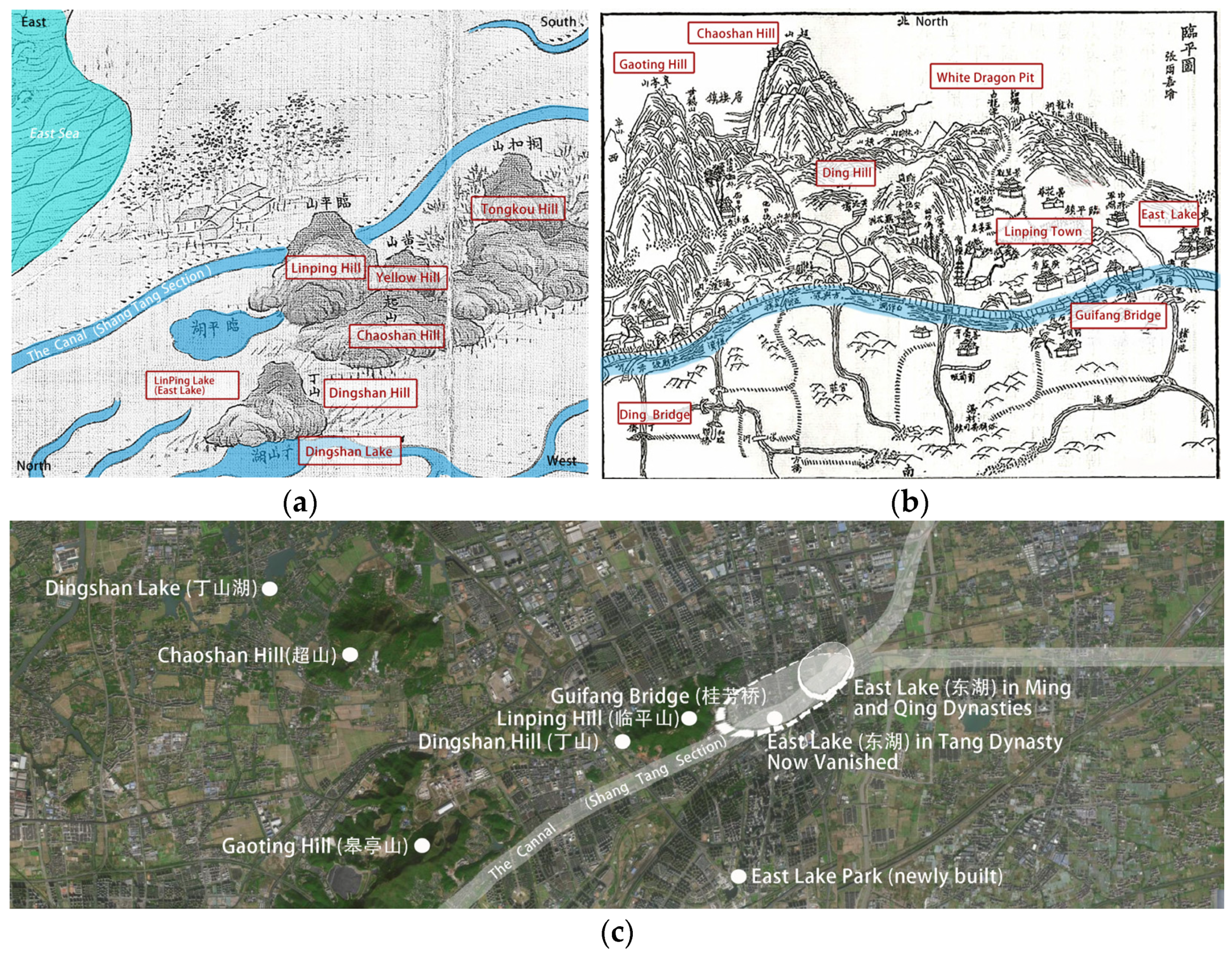
  71. Zhang, H. Tang Dynasty. Passing through Linping Lake. Three Songs of Living Under Linping Mountain in Shen, Q. eds “Linping Record” volume 4 in early qing dynasty.
  72. Ying, C. The distant Linping “Ten Scenes of East Lake”. Available online: https://blog.sina.com.cn/s/blog_16a9c348e0102wr8a.html (accessed on 28 July 2024).
  73. Zhejiang Government. Map of Hangzhou. In A Complete Map of Zhejiang (Partial); Bibliothèque Nationale de France: Paris, France, Early Qing Dynasty. [Google Scholar]
  74. Shen, Q. Linping Town Map. In Book of Linping; Qiantang Ding’s Jiahui Hall: Hangzhou, China, 1884; ISBN 9787807158264. [Google Scholar]
  75. Dika, I.R.; Anicic, B.; Krklec, K.; Andlar, G.; Hrdalo, I.; Perekovic, P. Cultural landscape evaluation and possibilities for future development—A case study of the island of Krk (Croatia). Acta Geogr. Slov.-Geogr. Zb. 2011, 51, 129–142. [Google Scholar] [CrossRef]
  76. Li, F. A study on the evolution of spatial structure of linear cultural heritage—with an account of the impact of tourism in it. Geogr. Geogr. Inf. Sci. 2019, 35, 133–140. [Google Scholar]
  77. Wang, S. Research on the Development of Historical Remains and Cultural Tourism Industry along the Grand Canal; Jilin University Press: Changchun, China, 2021. [Google Scholar]
  78. Delakorda, K.T. The Authenticity of the Hidden Christians’ Villages in Nagasaki: Issues in Evaluation of Cultural Landscapes. Sustainability 2021, 13, 4387. [Google Scholar] [CrossRef]
  79. Baotian-Nice. Illustration on the Theme of “Ten Scenes of Hangzhou Canals”. Available online: https://www.zcool.com.cn/work/ZNDI3NTA1NjQ=.html (accessed on 19 April 2024).
  80. Gauthier, P.; Gilliland, J. Mapping Urban Morphology: A Classification Scheme for Interpreting Contributions to the Study of Urban Form. Urban Morphol. 2006, 10, 41–50. [Google Scholar] [CrossRef]
  81. Ünlü, T.; Bas, Y. Morphological Processes and the Making of Residential Forms: Morphogenetic Types in Turkish Cities. Urban Morphol. 2017, 21, 105–122. [Google Scholar] [CrossRef]
  82. Conzen, M.P. How Cities Internalize Their Former Urban Fringes: A Cross-Cultural Comparison. Urban Morphol. 2009, 13, 29–54. [Google Scholar] [CrossRef]
  83. Tian, Y. Management units of urban morphology: Significance, formation and application. City Plan. Rev. 2021, 45, 9–16. [Google Scholar]
  84. Marcus, L.; Pont, M.B.; Barthel, S. Towards a Socio-Ecological Spatial Morphology: Integrating Elements of Urban Morphology and Landscape Ecology. Urban Morphol. 2019, 23, 115–124. [Google Scholar] [CrossRef]
  85. Lombardi, P.L.; Basden, A. Environmental Sustainability and Information Systems. Syst. Pract. 1997, 10, 473–489. [Google Scholar] [CrossRef]
Figure 1. (a) The Hangzhou section; (b) the location of the Hangzhou section in the Zhejiang section and the “canal in city” dilemma of Hangzhou; (c) the location of the Hangzhou section in the Beijing–Hangzhou Grand Canal (drawn by authors, adapted from [28,29]).
Land 13 01178 g001aLand 13 01178 g001b
Figure 2. Research framework (source: the authors).
Land 13 01178 g002
Figure 3. Ten Scenes of West Lake painted by Lan Y. in the Ming Dynasty, with Deep Cave and Valley on Feilai Peak (飞来洞壑) [35].
Land 13 01178 g003
Figure 4. Ten Scenes of West Lake painted by Ye X. in the Song Dynasty, with Autumn Moon on a Placid Lake (平湖秋月) [36].
Land 13 01178 g004
Figure 5. Realistic portrayal of Eight Views of Xiaoxiang by Zhang Y. in the Yuan Dynasty [30].
Land 13 01178 g005
Figure 6. Poetic portrayal of Eight Views of Xiaoxiang by the monk Shangrui in the Qing Dynasty [31].
Land 13 01178 g006
Figure 7. Value system of titled landscapes (source: the authors).
Land 13 01178 g007
Figure 8. Multidimensional value system for titled cultural landscapes of the canal (source: the authors).
Land 13 01178 g008
Figure 10. The transformation of East Lake. (a) A complete map of Zhejiang [73] (partial, upper east and lower west) in the early Qing Dynasty; (b) map of Linping Town in 1884 A.D., late Qing Dynasty [74]; (c). The relics of East Lake today (the authors).
Land 13 01178 g010
Figure 11. (a) Spatial settlement map of titled landscapes in place (source: the authors); (b) division of the basic analytical units of the cultural landscape and determination of the titles (source: the authors).
Land 13 01178 g011aLand 13 01178 g011b
Figure 12. TCS after refinement (source: the authors).
Land 13 01178 g012
Figure 13. Classification of evaluation scores of TCS (source: the authors).
Land 13 01178 g013
Figure 14. The synthesis of contributions for future decision-making and land management actions (source: the authors).
Land 13 01178 g014
Table 1. Multidimensional value system for cultural landscapes of the canal (source: the authors).
Primary IndicatorsSecondary IndicatorsTertiary IndicatorsPrimary IndicatorsSecondary IndicatorsTertiary Indicators
Conservation indication (C)Historic value (C.1.)Number of historical and cultural resource sites (C.1.1.)Developmental indicators (D)Landscape value (D.1.)Integrity of preservation (D.1.1.)
Conservation level of historical and cultural resource sites (C.1.2.)Diversity of elements (D.1.2.)
Conservation level of the heritage sections (C.1.3.)Spatial coherence (D.1.3.)
Cultural value (C.2.)Number of intangible cultural heritages (C.2.1.)Landscape coherence (D.1.4.)
Number of types of intangible cultural heritages (C.2.2.)Social value (D.2.)Educational value (D.2.1.)
Conservation level of intangible cultural heritages (C.2.3.)Service value (D.2.2.)
Spiritual value (C.3.)Availability of relevant traditional art works (C.3.1.)Economic value (D.3.)Usable value (D.3.1.)
Availability of relevant works of modern art (C.3.2.)Shipping value (D.3.2.)
Tourism value (D.3.3.)
Table 2. Conservation indicators (source: the authors).
Primary IndicatorsSecondary IndicatorsTertiary Indicators
Historic value (C.1.)Number of cultural landscape resource sites (C.1.1.)The total number of resource points within the clusters was calculated by combining the resource points at each level within ArcMap10.8.
Conservation level of cultural landscape resource sites (C.1.2.) National cultural heritage units: 5 points;
Provincial cultural heritage units: 4 points;
Municipal cultural heritage units and sites: 3 points;
Other historical and cultural resource sites: historic buildings and industrial heritage and contemporary cultural landscape resource sites: 2 points.
Conservation level of the heritage sections (C.1.3.)Class I protected riverbank: 3 points;
Class II protected riverbank: 2 points;
Class III protected riverbank: 1 point;
Non-heritage section of river: 0 points.
Cultural value (C.2.)Number of intangible cultural heritages (C.2.1.)Number of intangible cultural heritages.
Number of types of intangible cultural heritages (C.2.2.)Intangible cultural heritages are categorized into 10 categories in accordance with the Representative List of Intangible Cultural Heritage at the National Level (ICH) as follows: folklore, traditional music, traditional dance, traditional drama, opera, traditional sports, performing arts and acrobatics, traditional fine arts, traditional arts and crafts, traditional medicine, and folklore. Only the number of intangible heritage categories within the clusters is counted in this indicator.
Conservation level of intangible cultural heritages (C.2.3.)2 points for items on the national ICH list; 1 point for items on other ICH lists; and 0 points for no ICH on site.
Spiritual value (C.3.)Availability of relevant traditional art works (C.3.1.)With: 1 point; without: 0 points.
Availability of relevant works of modern art (C.3.2.)With: 1 point; without: 0 points.
Table 3. Developmental evaluation indicators (source: the authors).
Primary IndicatorsSecondary IndicatorsTertiary Indicators
Landscape value (D.1.)Integrity of preservation (D.1.1.)The extent to which the components of the cultural landscape have been maintained in terms of their composition and during their development.
Diversity of elements (D.1.2.)This refers to cultural landscapes that are themselves diverse in structures and functions, reflecting the complexity of the assemblage.
Spatial coherence (D.1.3.)Whether the building heights and skyline within the cultural landscape meet the height requirements of the Grand Canal zoning district and the requirements for the view corridors of important nodes along the Grand Canal.
Landscape coherence (D.1.4.)Whether the cultural landscape’s architectural style and volume are in harmony with the landscape along the canal and the traditional architectural style, and whether they meet the aesthetic requirements for the important interfaces along the Grand Canal.
Social value (D.2.)Educational value (D.2.1.)This refers to whether the cultural, scientific, artistic, historical, and other values can enhance the social, cultural, and spiritual cultivation of visitors through tourism and publicity.
Service value (D.2.2.)Whether it can provide diversified public services, thereby enhancing the quality of life for residents along the canal.
Economic value (D.3.)Usable value (D.3.1.)This refers mainly to the economic value of the canal’s cultural landscape that can be generated directly by its continued use.
Shipping value (D.3.2.)Whether the cultural landscape of the canal can enhance the function of flood control and drainage conservation, optimize allocation of water resources, promote shoreline conservation and wharf service enhancement, etc., so as to enhance the navigability of the canal waterway and contribute to the regional shipping value.
Tourism value (D.3.3.)This refers to whether the cultural landscape can enhance the tourism infrastructure and supporting services with cultural and tourism integration to develop high-quality canal tourism routes and products, or to build a canal cultural exchange platform.
Disclaimer/Publisher’s Note: The statements, opinions and data contained in all publications are solely those of the individual author(s) and contributor(s) and not of MDPI and/or the editor(s). MDPI and/or the editor(s) disclaim responsibility for any injury to people or property resulting from any ideas, methods, instructions or products referred to in the content.

