Abstract
Visual quality and impact assessments have historically relied on experts to formally evaluate the visual properties of a landscape. In contrast, environmental psychologists have studied subjective landscape preferences using ratings and surveys. These two approaches represent, respectively, the “objectivist” and “subjectivist” paradigms within visual landscape research. A gap, however, exists between these approaches: actual observation behaviors. In this paper, we argue for the inclusion of eye-tracking research in visual landscape assessments as a critical bridge between objective landscape qualities and subjective visual experiences. We describe the basics of eye-tracking methods and data types to introduce the role of eye movements in landscape preference formation. Three-dimensional immersive virtual environments are particularly useful for collecting these types of data, as they allow for quantification of the viewed environment’s spatial and scene metrics in addition to providing eye-tracking capabilities at sufficient resolutions. These environmental and behavioral data can then be consolidated and analyzed within existing GIS platforms to draw conclusions about environmental influences on observation behaviors. While eye tracking may eventually contribute directly to the practice of visual quality or impact assessments, the near-term benefits of this work will most likely center around contributing to the objectivity and defensibility of assessments through validation and methodological recommendations.
1. Introduction
In the last fifty years, methods for documenting baseline and altered visual landscapes have primarily relied on objective measurements of physical landscape characteristics [1]. In that time, researchers have regularly explored opportunities to improve the validity and reliability of these assessments [2,3,4,5]. Most of these assessments rely on expert evaluations and, occasionally, include public comments and preference surveys to produce visual impact sensitivity analyses. From a theoretical perspective, expert evaluations and public surveys represent contrasting approaches to the question of landscape quality. On the one hand, professional assessments tend to assign scenic quality as a value inherent in the landscape. On the other hand, sensitivity analyses assume that scenic value is a subjective experience inherent to the viewer. As such, the juxtaposition of expert and public within assessments represents a combination of objective landscape qualities and the more subjective visual perceptions of viewers [6]. These binary approaches, despite being written about extensively, have left significant gaps concerning the holistic integration of methods and data types covering the full spectrum from raw spatial data through perception to preference.
On either side of these gaps, both paradigms have developed numerous methodologies for measuring their respective scenic landscape constructs. Objectivist methods, like the US Forestry Service’s former Visual Resource Management (VRM) system, assigned values using formal design elements. The VRM system used scenic quality evaluations, sensitivity analyses, and distance zones to classify landscapes based on factors like landforms and vegetation. The US Army Corps of Engineers introduced another objectivist method, the Visual Resource Assessment Procedure (VRAP), for standardizing esthetic considerations and focusing on expert-defined classifications supported by public input. In contrast, subjectivist paradigms assess cognitive, emotional, and physical experiences. For example, the Scenic Beauty Estimation Method (SBE) rates landscapes based on viewer perceptions and internal judgments [7], and these methods have evolved to incorporate newer surveys and physiological measures [8]. Other studies explored landscape preferences related to natural versus developed landscape scenes. For example, Kaplan’s [9] framework links preferences to understanding, exploration, coherence, and complexity, and similar work has contributed to the rise of cognitive [10] and esthetic–spatial approaches [11]. Additionally, Gibson’s ecological perception theory emphasized perceived affordances within a landscape, which, in turn, shaped esthetic preferences based on the viewer’s needs [12].
The debate between paradigms centers on whether esthetics are inherent qualities or subjective experiences. While objectivist methods dominate current visual impact assessment practices, calls for combining expert and public assessments and exploring experiential changes highlight the need for a balanced approach [6]. Both approaches incorporate aspects of spatial, scene, and preference rating variables, but a crucial link between these factors remains missing: the observers’ viewing behaviors.
It should be noted that this paper uses terms such as “landscape assessment” and “impact assessment” broadly and interchangeably. In exploring the interface between psychological perception research and professional visual landscape management practices, this research specifically questions the boundaries between these various approaches. Palmer [13] notes that the goals of environmental perception research are distinct from but related to the goals of visual impact assessments. While the former is typically a type of fundamental research exploring the human experience of landscape, the latter measures and evaluates particular scenes’ potential impact from proposed landscape projects or management strategies.
As such, this paper argues that landscape assessment methods stand to gain from emerging research in viewing behavior and other physiological responses as objective measures of previously considered “subjective” visual landscape experiences. In particular, eye tracking in 3D immersive environments offers an opportunity to analyze observation patterns in direct response to dynamic visual landscapes. We argue that eye-tracking analysis can help bridge the gap between objectivist and subjectivist approaches to visual landscape quality by collecting and analyzing data about viewers’ observation patterns (i.e., viewing behaviors), a key gap in current methodologies (Figure 1). We hope that by implementing this approach, visual quality and impact assessments may become more valid, more defensible, and faster. Furthermore, quantitatively connecting objectivist and subjectivist methods may create methods that provide a more equitable balance between professional land use guidance and public landscape preferences.
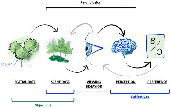
Figure 1.
Conceptual diagram demonstrating the flow of information during landscape preference formation. Environmental spatial data determine scene characteristics, which are visually sampled by viewing behaviors. The raw visual data are processed by the perceptual components of the nervous system, interpreted, and then yield visual preferences. These preferences may, in turn, influence viewing behavior to resample the scene characteristics. Objectivist approaches to visual quality and impact assessment tend to focus on spatial data and scene characteristics, while subjectivist approaches historically focus on scene characteristics, perception, and preferences. A psychological approach provides methods to bridge the resulting gap through eye tracking.
In order to integrate psychological perception and visual resource practices, however, the methods, data types, and goals of each field must be assessed for their potential compatibility. This paper is a first step in that comparison by presenting a brief overview of eye-tracking methods along with a conceptualized workflow for integrating the field with more traditional spatial analysis. The novelty and value of this contribution lie in the movement towards a more holistic understanding of the interplay between landscape spatial metrics, the spatial properties of perceptual mechanisms mediating the interaction between viewer and landscape, and psychological phenomena such as spatial cognition and landscape preference.
2. A Brief Overview of Eye Tracking
To assess the value of eye tracking in visual landscape studies, we will first describe the fundamental aspects of eye tracking. Through vision, humans can detect relationships between spatial elements and semantic themes in environments [14] but often cannot explicitly identify how or why this is performed. Relationships between visual variables such as color, luminance, texture, parallax, and perspective all influence the visual perception system detecting these changes. There are techniques to measure these relationships objectively, but these relationships still need to be associated with semantic meaning to understand perception beyond simple sensation [15,16]. To accomplish this, research can consider the set of eye movements as a storyline between meaning, perception, and the environment. These eye movements are highly distinct among individuals based on their behaviors, experiences, tasks, and cognitive states [17]. However, as a population, we are influenced by the different environmental variables with some degree of similarity, which can result in a more structured, empirical, and—importantly—potentially predictable conceptualization of space. For example, pedestrians crossing a bridge may each have a distinct visual experience based on their unique spatial positions, interests and goals, and optical abilities, but to cross the bridge in the first place, they must all share a basic understanding of the bridge’s spatial position and orientation.
As such, eye movements directly relate to a significant portion of the environmental data an individual collects and responds to during navigation [18]. Given eye movements’ significant connection to spatial cognition, eye movements may have similar relationships with an individual’s evaluation of, or preference for, visual landscapes. Prior research supports this hypothesis. Of particular interest, Zhou et al. [19] found that some eye movements were significantly associated with particular types of preferences, but in some cases, the same eye movement patterns were associated with opposite preferences. This finding suggests that while some eye movements may be more common with certain preference types, some eye movement patterns may be more closely related to the visual task being conducted, such as searching or evaluation. A deeper understanding of the eye movements and viewing behaviors associated with different cognitive tasks is crucial for parsing these differences and could lead to more useful eye movement-based assessments of landscape characters or scenery.
In most modern eye tracking, a set of cameras produces a range of metrics based on scene reflections off different layers of the cornea or the relative size and orientation of the eye’s anatomy, such as the iris, pupil, or sclera [20]. Combining data about the speed, position, and size of the pupil can produce information about the viewer’s gaze direction, cognitive load (i.e., mental effort), viewing behavior, etc. [21,22]. These data can then be combined with the environment’s spatial data to map specifically viewed locations in 3D space [23]. With commercially available equipment, data can be collected at frequencies over sixty times per second and can produce a massive series of data about a viewed scene. Useful output metrics from these practices include fixations (locations or objects that are visually processed) and saccades (large eye movements between fixations), the patterns of which can be analyzed in the context of cognitive tasks and events. These data can then be clustered to reveal areas of interest (AOIs), heat maps, and scan paths (the sequential route between fixations in a 3D space) based on the spatial and temporal distribution of gaze locations in the viewer’s environment. AOIs describe semantically labeled zones within a field of view or associated with objects. Heat maps can provide an overlay that communicates the frequency of fixation per unit area in a scene. Finally, scan paths examine directions, frequencies, and distances between gaze point movements during an experiment [21]. Together, this paradigm of eye-tracking research has linked gaze behavior to cognitive events and locomotion, and associated advances in human–computer interaction have led to gaze-controlled communication systems, prosthetics, and other medical assistive devices and treatments [24].
3. Leverage Eye Tracking in 3D Immersive Environments
The subjectivity of landscape ratings often obscures the latent variable of esthetic preferences [7]. Today, however, techniques in spatial analysis and scene statistics (quantitative measures of a scene’s visual properties) offer the ability to quantify landscapes and scenes in new ways, particularly with the evolution of computer vision [25]. Singular landscape photographs are a mostly reliable landscape representation method with significant exceptions [5], but integrating newer cognitive and behavioral measures requires an understanding of the relationship between scenes and their spatial relationships. Without spatial data, a comparison of scenes and preferences lacks a critical component because visual stimuli are perceptually ambiguous, meaning a given visual perception may either lack clear meaning, be interpreted in multiple ways, or be generated by different stimuli.
These spatial data can be difficult to capture in practice. Collecting precise spatial data for individual scenes requires either LiDAR scans of the exact scene pictured or raster calculations, such as viewsheds or visual magnitude, based on the observation point and high-resolution digital elevation models. This method can capture spatial data for individual observation points or routes [26], but applying that data collection to a dynamic, real-world environment becomes challenging. Additionally, random elements and events in the real world add an abundance of uncontrolled elements to such an experiment. In contrast, immersive virtual reality technologies offer the ability to create controlled environments with known and easily recorded spatial and temporal data. The trade-off in these contexts is that real-world experiments gain external validity, whereas immersive VE experiments have higher internal validity. As such, real-world experiments may provide more descriptive, generalizable results with limited ability to draw conclusions about causation, while immersive VE experiments are likely to generate more precise results with a strong capacity to draw conclusions about causation, although the generalizability of the results is more restricted.
4. Integrating Spatial Analysis and Eye-Tracking Data
Recently, landscape researchers have incorporated eye tracking into studies of landscape esthetics, safety, psychology, and education [27]. Particularly relevant for landscape architects and associated professionals, Dupont et al. [28,29,30] have produced a robust research agenda using eye tracking to evaluate between-subject and within-subject differences in gaze behavior across multiple landscape scenarios. Specifically, Dupont’s research program found that gaze behavior varied significantly when the type of photograph used in landscape assessment surveys was changed and when the homogeneity and enclosure of the pictured landscape were manipulated as well [28]. Dupont et al. [29] further proposed a “saliency map” to predict subjects’ areas of interest within landscape photographs based on differing elements [30]. Overall, Dupont’s research program indicates that media format, scene composition, semantic meanings, and design features such as style and color influence how individuals look at landscapes.
In general, eye tracking presents several advantages for landscape assessment research. For instance, eye-tracking measurements provide a robust, objective measure of a viewer’s interaction with a visual stimulus such as a landscape. These quantifiable behavior metrics can then be correlated with subjective landscape ratings, quantified landscape features can be used to predict areas of interest, or group-level differences can be determined in viewing patterns. Semantic preferences and legibility can also be inferred from visual behavior, and, in combination with physiological metrics such as skin conductivity, affective arousal can be inferred and related to visual experiences [8]. Given the prevalence of visibility-based concerns around renewable energy development, understanding visual experiences around these developments will be vital in addressing community concerns. Such research could also differentiate between visibility concerns and misattributed social concerns that may receive less attention in the renewable energy development process [31,32].
These advantages address a need in the field of landscape esthetics for increasingly valid and objective assessment practices, as described by Daniel [1]. Currently, several GIS tools offer quantitative landscape assessment methods [33], but these are often focused on the data manipulation and visualization domains of spatial analysis. Several studies expand into quantitative spatial analyses of landscapes’ visibility, land use, and landform [34], and another study even maps crowdsourced landscape preferences from surveys or web-based photo-sharing platforms [35]. However, these methods do not provide a means to associate the behavioral processes of observation with the rationale for the different measures or ratings. In basic research, good peer review always asks, “How was this data collected?” to examine potential biases in the collection process; applying the same question to individuals’ visual landscape preferences offers a chance to parse visual preferences and account for an individual’s perceptual biases. Eye-tracking data are fundamentally spatiotemporal and may include an observer’s position, their point of regard (where they are looking in the environment), geographic coordinates in space for both, and a time stamp. The point of regard may be associated with quantitative metrics and qualitative features at its location, such as an object’s semantic meaning or unique texture, color, brightness, and other elements used in the objectivist paradigm of visual impact assessment. Points of regard, along with their temporal qualities and attributes, can then be input into a GIS and used to facilitate empirical validation of GIS-based impact assessment tools. Additionally, scan paths can also be integrated within GIS, allowing for the quantification of areas of interest in terms of physical or visual scope as well as time spent looking at each one. While GIS is well suited to measure and produce visualizations of eye-tracking data, a GIS is not strictly necessary to analyze these data. Spatial analysis with GIS is not currently a standard practice when analyzing eye-tracking data. However, spatial analysis offers new opportunities for eye-tracking analysis.
To describe these opportunities, Figure 2 adapts Orquin and Holmqvist’s [36] workflow for eye-tracking analysis and Unwin’s [37] categories of spatial analysis to visualize how these distinct processes and data products can interact. In Orquin and Holmqvist’s [36] approach, appropriately collected and cleaned eye-tracking data go through a series of analytic steps, beginning with clustering the raw data into fixations and saccades. This step identifies which tracking frames are most likely to coincide with active visual processing. Spatial coordinates for raw data points can be retained at this stage or averaged across clusters to simplify the data set. At this point, the clustered data are sufficient for mapping through spatial data manipulation, the first of Unwin’s spatial data analysis categories, which also include spatial statistics, exploratory data analysis, and spatial modeling [37]. Unwin’s categories correspond to goals focused on mapping, describing, analyzing, and predicting. In the proposed workflow, eye-tracking data at any level can be spatially analyzed as long as it retains its spatial coordinates throughout the data management and analysis processes. In this process, the spatial coordinates of the viewer can be just as important as the coordinates of their fixations and saccades. This distinction between viewer and viewed positions allows for the examination of the impact of individual elements within the scene over the course of an experiment, as well as analyses of how viewing behaviors change with respect to viewer position.
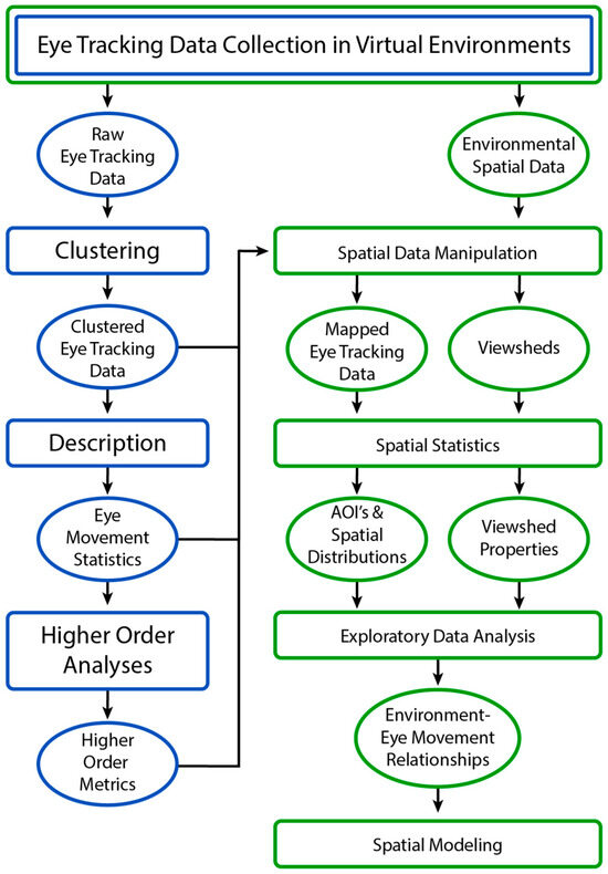
Figure 2.
Orquin and Holmqvist’s [37] workflow clusters statistically describe and analyze eye-tracking data. These analysis products can be tied to their respective spatial coordinates, mapped, and analyzed for relationships with viewshed properties, leading to the potential for predictive spatial modeling of environmental impacts on observers’ viewing behavior.
Traditional eye-tracking analyses are often conducted using 2D stimuli (e.g., photos), but some of the core metrics, such as AOIs, also apply to 3D spaces. Spatial analysis, often performed using GIS, has the distinct advantage of incorporating 3D quantitative environmental elements (e.g., topography and user movement) into the evaluation, allowing for a richer, more context-sensitive understanding. Tools like ArcGIS offer basic functions for spatial analysis, while advanced statistical tools (e.g., R) can provide a range of additional measures. Regardless of the analytical technique, the primary strength of spatial analysis lies in its ability to offer comprehensive viewshed descriptions, providing a depth of environmental context that traditional analyses typically lack. So, not only can we develop fine-grained measures, such as total dwell time on a specific object, but we can also develop powerful global measures, such as hotspot maps and viewing extents, to provide a more holistic, objective measure of landscape perception. These environmental metrics add important context to the behavioral and physiological data by describing not only what is seen but also the setting in which something is seen, which has been shown to influence viewing behavior and preferences [8,28].
5. Discussion
Following the existing typology of landscape assessments, eye tracking could be used in surveys or perceptual preference evaluations. In surveys, eye tracking could be used to gauge the distribution of fixations within landscapes and across groups. Such distributions could be used to measure the relative importance of distinct landscape features between groups and would necessitate the description of viewer populations as part of a visual inventory. In preference evaluations, eye tracking could potentially serve as a tool for standardizing individuals’ disparate preference scales (see Daniel’s Scenic Beauty Estimation Method) for specific elements by weighting ratings according to the amount and type of visual attention they receive.
Integrating eye-tracking data with traditional methods such as surveys and scenic beauty estimation allows for a multifaceted approach to visual quality assessments. Eye tracking can validate or challenge the results obtained from more conventional methods, offering a way to cross-check for reliability and accuracy. This would allow practitioners to compare how observational patterns might change in response to changes in infrastructure (e.g., wind turbine, gas, or oil pump). For example, Zhou et al. [19] found significant differences in related eye movement metrics for different categories of landscape elements, such as waterscapes or facilities, although further research is necessary to replicate these findings. On the other hand, if the patterns remain stable while ratings change, it would motivate more studies on landscape interpretations. For example, if a participant highly rates a landscape and then lowers their rating after the installation of a wind turbine, we can then measure the relationship between changes in observational patterns and changes in landscape ratings. The eye-tracking data can then be assessed alongside feelings of comfort, attraction, pleasure, and curiosity as a suite of variables feeding into final ratings. Eye tracking could help researchers better understand how to measure observational patterns and their interrelationship with emotional responses. Thus, combining ratings, preference surveys, and eye tracking may improve how experts conduct their assessments and create visual impact mitigation strategies.
Eye tracking also offers another means to explore unconscious and physiological responses to elements of visual landscape experiences. While eye tracking can provide attentional metrics about viewing behavior, these could also be coupled with physiological responses and stated preferences. This approach could be applied to key observation points, recreational routes, or urban settings. Once again, data about the specific elements and observational behaviors can be leveraged to understand their association with stress and restoration rather than relying on broader global statistics (e.g., topography, greenspace). We might further investigate the role of spatial cognition in visual landscape preferences and integrate components of viewing behavior, physiology, and spatial metrics.
Further, eye tracking allows for descriptions of group-level differences in observation patterns. These differences may stem from different expectations about a landscape’s contents as well as differences in the relative salience of environmental features to each viewer. Since each individual has a different visual experience of the same landscape, knowing what elements they viewed, in what order, and for how long may provide significant insight into the raw data underpinning their eventual landscape rating. These differences may also imply unconscious preference ratings and may help compare public and professional assessments.
6. Conclusions
Eye-tracking research offers a bridge between existing objectivist and subjectivist landscape assessment methods by bringing observational patterns—a critical link between scene metrics and viewers’ perceptions—into the research agenda. While eye tracking may eventually contribute directly to the practice of visual quality or impact assessments, the near-term benefits of this work will most likely center around contributing to the objectivity and defensibility of assessments through validation and methodological recommendations. The ongoing integration of eye-tracking research with spatial analytics also offers a promising avenue for refining existing viewshed metrics and creating new methods for exploring the spatial properties of visual experiences. In particular, exploratory spatial analyses may provide us with greater insight into the role of geographic variables in shaping observation patterns, perceptions, and subsequent preference ratings.
This paper provides the next step toward quantifying cumulative visual impacts as objective behavioral and physiological responses. This can help strengthen the defensibility of our assessments and increase the generalizability of our results. Accomplishing both of these will require a more data-driven approach to understanding the perceptual processes involved in perceiving and interpreting visual landscape changes, and eye tracking can provide rich data capturing behavioral indicators of those processes.
The most immediate limitation of this work is its current conceptual nature. As noted, the fields of eye tracking, landscape perception, and landscape or impact assessments are well established, but their effective integration has received limited attention. Future eye-tracking research should explore the role of viewing behaviors in the distinct realms of landscape perception, landscape character assessment, and visual impact assessment to further identify the most appropriate and beneficial applications of eye-tracking techniques.
Author Contributions
Conceptualization, D.E. and B.C.; methodology, D.E.; investigation, D.E; resources, B.C.; writing—original draft preparation, D.E.; writing—review and editing, D.E. and B.C.; visualization, D.E.; supervision, B.C.; project administration, B.C.; funding acquisition, B.C. All authors have read and agreed to the published version of the manuscript.
Funding
This research was supported by the Utah Agricultural Experiment Station, Utah State University, and approved as journal paper number 9814.
Data Availability Statement
No new data were created or analyzed in this study. Data sharing is not applicable to this article.
Acknowledgments
We gratefully acknowledge Jeanine Stefanucci for her critiques on our review of psychological theory and relevant diagrams.
Conflicts of Interest
The authors declare no conflicts of interest.
References
- Daniel, T.C. Whither Scenic Beauty? Visual Landscape Quality Assessment in the 21st Century. Landsc. Urban Plan. 2001, 54, 267–281. [Google Scholar] [CrossRef]
- Clay, G.R.; Smidt, R.K. Assessing the Validity and Reliability of Descriptor Variables Used in Scenic Highway Analysis. Landsc. Urban Plan. 2004, 66, 239–255. [Google Scholar] [CrossRef]
- Higuera-Trujillo, J.L.; López-Tarruella Maldonado, J.; Llinares Millán, C. Psychological and Physiological Human Responses to Simulated and Real Environments: A Comparison between Photographs, 360° Panoramas, and Virtual Reality. Appl. Ergon. 2017, 65, 398–409. [Google Scholar] [CrossRef] [PubMed]
- Palmer, J.F. Reliability of Rating Visible Landscape Qualities. Landsc. J. 2000, 19, 166–178. [Google Scholar] [CrossRef]
- Palmer, J.F.; Hoffman, R.E. Rating Reliability and Representation Validity in Scenic Landscape Assessments. Landsc. Urban Plan. 2001, 54, 149–161. [Google Scholar] [CrossRef]
- Lothian, A. Landscape and the Philosophy of Aesthetics: Is Landscape Quality Inherent in the Landscape or in the Eye of the Beholder? Landsc. Urban Plan. 1999, 44, 177–198. [Google Scholar] [CrossRef]
- Daniel, T.C.; Boster, R.S. Measuring Landscape Esthetics: The Scenic Beauty Estimation Method; USDA Forest Service Research Paper RM-167; Department of Agriculture, Forest Service, Rocky Mountain Forest and Range Experiment Station: Fort Collins, CO, USA, 1976. [Google Scholar]
- Spielhofer, R.; Thrash, T.; Hayek, U.W.; Grêt-Regamey, A.; Salak, B.; Grübel, J.; Schinazi, V.R. Physiological and Behavioral Reactions to Renewable Energy Systems in Various Landscape Types. Renew. Sustain. Energy Rev. 2021, 135, 110410. [Google Scholar] [CrossRef]
- Kaplan, S. Aesthetics, Affect, and Cognition: Environmental Preference from an Evolutionary Perspective. Environ. Behav. 1987, 19, 3–32. [Google Scholar] [CrossRef]
- Herzog, T.R. A Cognitive Analysis of Preference for Urban Spaces. J. Environ. Psychol. 1992, 12, 237–248. [Google Scholar] [CrossRef]
- Hagerhall, C.M.; Purcell, T.; Taylor, R. Fractal Dimension of Landscape Silhouette Outlines as a Predictor of Landscape Preference. J. Environ. Psychol. 2004, 24, 247–255. [Google Scholar] [CrossRef]
- Gibson, J.J. The Theory of Affordances. Hilldale 1977, 1, 67–82. [Google Scholar]
- Palmer, J.F. A Diversity of Approaches to Visual Impact Assessment. Land 2022, 11, 1006. [Google Scholar] [CrossRef]
- Bruns, C.; Chamberlain, B. The Influence of Landmarks and Urban Form on Cognitive Maps Using Virtual Reality. Landsc. Urban Plan. 2019, 189, 296–306. [Google Scholar] [CrossRef]
- Engbert, R.; Trukenbrod, H.A.; Barthelmé, S.; Wichmann, F.A. Spatial Statistics and Attentional Dynamics in Scene Viewing. J. Vis. 2015, 15, 14. [Google Scholar] [CrossRef] [PubMed]
- Zetzsche, C. CHAPTER 37—Natural Scene Statistics and Salient Visual Features. In Neurobiology of Attention; Itti, L., Rees, G., Tsotsos, J.K., Eds.; Academic Press: Burlington, MA, USA, 2005; pp. 226–232. ISBN 978-0-12-375731-9. [Google Scholar]
- Liao, H.; Zhao, W.; Zhang, C.; Dong, W.; Huang, H. Detecting Individuals’ Spatial Familiarity with Urban Environments Using Eye Movement Data. Comput. Environ. Urban Syst. 2022, 93, 101758. [Google Scholar] [CrossRef]
- Liao, H.; Zhao, W.; Zhang, C.; Dong, W. Exploring Eye Movement Biometrics in Real-World Activities: A Case Study of Wayfinding. Sensors 2022, 22, 2949. [Google Scholar] [CrossRef] [PubMed]
- Zhou, X.; Cen, Q.; Qiu, H. Effects of Urban Waterfront Park Landscape Elements on Visual Behavior and Public Preference: Evidence from Eye-Tracking Experiments. Urban For. Urban Green. 2023, 82, 127889. [Google Scholar] [CrossRef]
- Cognolato, M.; Atzori, M.; Müller, H. Head-Mounted Eye Gaze Tracking Devices: An Overview of Modern Devices and Recent Advances. J. Rehabil. Assist. Technol. Eng. 2018, 5, 205566831877399. [Google Scholar] [CrossRef] [PubMed]
- Holmqvist, K.; Nyström, M.; Andersson, R.; Dewhurst, R.; Jarodzka, H.; van de Weijer, J. Eye Tracking: A Comprehensive Guide to Methods and Measures; Oxford University Presss: New York, NY, USA, 2011; ISBN 978-0-19-162542-8. [Google Scholar]
- Kiefer, P.; Giannopoulos, I.; Duchowski, A.; Raubal, M. Measuring Cognitive Load for Map Tasks Through Pupil Diameter. In Geographic Information Science; Miller, J.A., O’Sullivan, D., Wiegand, N., Eds.; Lecture Notes in Computer Science; Springer International Publishing: Cham, Switzerland, 2016; Volume 9927, pp. 323–337. ISBN 978-3-319-45737-6. [Google Scholar]
- Chamberlain, B.; Johnson, S.; Spencer, C.; Evans, D.; Fernberg, P.; Tighe, E.; LaFavers, M.; Creem-Regehr, S.; Stefanucci, J. Visualizing and Clustering Eye Tracking within 3D Virtual Environments. J. Digit. Landsc. Archit. 2023, 8, 318–325. [Google Scholar]
- Päivi, M. Gaze Interaction and Applications of Eye Tracking: Advances in Assistive Technologies: Advances in Assistive Technologies; IGI Global: Hershey, PA, USA, 2011; ISBN 978-1-61350-099-6. [Google Scholar]
- Seiferling, I.; Naik, N.; Ratti, C.; Proulx, R. Green Streets − Quantifying and Mapping Urban Trees with Street-Level Imagery and Computer Vision. Landsc. Urban Plan. 2017, 165, 93–101. [Google Scholar] [CrossRef]
- Openshaw, G.; Chamberlain, B. Optimizing Viewpoint Selection for Route-Based Experiences: Assessing the Role of Viewpoints on Viewshed Accuracy. Land 2022, 11, 1324. [Google Scholar] [CrossRef]
- Chen, X.; Qiao, L. Applicable Prospects of Eye Tracking Technology in the Research of Landscape Visual Perception. IJMUE 2015, 10, 111–118. [Google Scholar] [CrossRef]
- Dupont, L.; Antrop, M.; Van Eetvelde, V. Eye-Tracking Analysis in Landscape Perception Research: Influence of Photograph Properties and Landscape Characteristics. Landsc. Res. 2014, 39, 417–432. [Google Scholar] [CrossRef]
- Dupont, L.; Ooms, K.; Antrop, M.; Van Eetvelde, V. Comparing Saliency Maps and Eye-Tracking Focus Maps: The Potential Use in Visual Impact Assessment Based on Landscape Photographs. Landsc. Urban Plan. 2016, 148, 17–26. [Google Scholar] [CrossRef]
- Dupont, L.; Ooms, K.; Antrop, M.; Van Eetvelde, V. Testing the Validity of a Saliency-Based Method for Visual Assessment of Constructions in the Landscape. Landsc. Urban Plan. 2017, 167, 325–338. [Google Scholar] [CrossRef]
- Baxter, J.; Morzaria, R.; Hirsch, R. A Case-Control Study of Support/Opposition to Wind Turbines: Perceptions of Health Risk, Economic Benefits, and Community Conflict. Energy Policy 2013, 61, 931–943. [Google Scholar] [CrossRef]
- Kirchhoff, T.; Ramisch, K.; Feucht, T.; Reif, C.; Suda, M. Visual Evaluations of Wind Turbines: Judgments of Scenic Beauty or of Moral Desirability? Landsc. Urban Plan. 2022, 226, 104509. [Google Scholar] [CrossRef]
- Manyoky, M.; Wissen Hayek, U.; Heutschi, K.; Pieren, R.; Grêt-Regamey, A. Developing a GIS-Based Visual-Acoustic 3D Simulation for Wind Farm Assessment. ISPRS Int. J. Geo-Inf. 2014, 3, 29–48. [Google Scholar] [CrossRef]
- Chamberlain, B.C.; Meitner, M.J. A Route-Based Visibility Analysis for Landscape Management. Landsc. Urban Plan. 2013, 111, 13–24. [Google Scholar] [CrossRef]
- Dunkel, A. Visualizing the Perceived Environment Using Crowdsourced Photo Geodata. Landsc. Urban Plan. 2015, 142, 173–186. [Google Scholar] [CrossRef]
- Orquin, J.L.; Holmqvist, K. A Primer on Eye-Tracking Methodology for Behavioral Science. In A Handbook of Process Tracing Methods; Schulte-Mecklenbeck, M., Kühberger, A., Johnson, J.G., Eds.; Routledge: Abingdon, UK, 2019; pp. 53–64. ISBN 978-1-315-16055-9. [Google Scholar]
- Unwin, D.J. GIS, Spatial Analysis and Spatial Statistics. Prog. Hum. Geogr. 1996, 20, 540–551. [Google Scholar] [CrossRef]


Disclaimer/Publisher’s Note: The statements, opinions and data contained in all publications are solely those of the individual author(s) and contributor(s) and not of MDPI and/or the editor(s). MDPI and/or the editor(s) disclaim responsibility for any injury to people or property resulting from any ideas, methods, instructions or products referred to in the content. |
© 2024 by the authors. Licensee MDPI, Basel, Switzerland. This article is an open access article distributed under the terms and conditions of the Creative Commons Attribution (CC BY) license (https://creativecommons.org/licenses/by/4.0/).