Article

Bird Diversity in Suburban Greenway Was Driven by Habitat Heterogeneity and Landscape Patterns in Autumn–Winter Seasons—Evidence from Hangzhou Qingshan Lake Greenway

1
College of Landscape Architecture, Zhejiang A&F University, Hangzhou 311300, China
2
School of Life Science, Westlake University, Hangzhou 310030, China
3
School of Humanities and Law, Zhejiang A&F University, Hangzhou 311300, China
*
Author to whom correspondence should be addressed.
These authors contributed equally to this work.
Land 2024, 13(8), 1192; https://doi.org/10.3390/land13081192
Submission received: 14 July 2024 / Revised: 29 July 2024 / Accepted: 31 July 2024 / Published: 2 August 2024

Abstract

:
Understanding the spatial heterogeneity of bird community distribution within urban greenways is crucial for optimizing ecological functions and supporting urban biodiversity. While ecological corridors enhance connectivity and biodiversity, specific mechanisms by which landscape composition and configuration influence bird diversity remain unclear. This study examines bird community distribution along the Qingshan Lake Greenway in Hangzhou during autumn and winter, using 17 observation points across wetlands, forests, and mixed habitats. The key findings indicate that wetlands have significantly higher species richness compared to forests and mixed habitats, underscoring wetlands’ critical role in supporting diverse bird communities. Greenways primarily facilitate short-distance bird movement with limited permeability between habitats. Additionally, greenway effectiveness in enhancing bird diversity depends heavily on design and structural characteristics. This research highlights the necessity of incorporating microhabitat design and diverse habitat configurations in greenway planning to enhance ecological connectivity and biodiversity. It provides essential insights for urban planners and ecologists, emphasizing detailed landscape composition and configuration analyses. Future research should include year-round studies and advanced ecological monitoring technologies to validate and expand these findings, ultimately contributing to more effective urban biodiversity conservation and sustainable development strategies.

1. Introduction

In recent years, with the accelerated pace of urbanization, biodiversity, particularly regarding avian species, has faced significant decline risks [1,2]. The increasing proportion of impervious surfaces in cities, such as roads and buildings, has led to the drastic reduction in and fragmentation of natural habitats, severely degrading the quality of avian habitats [2]. Concurrently, the intensity of anthropogenic disturbances, including traffic noise, light pollution, and human activities, has been rising, further simplifying avian community structures and reducing species diversity [3]. These changes not only threaten the survival and reproduction of bird populations but also lead to the marked degradation of ecosystem services. The decline in avian biodiversity has profound and far-reaching impacts on ecosystem services. Birds play pivotal roles in ecosystems, such as pest control, seed dispersal, and pollination. The reduction in these functions adversely affects ecosystem health and stability, as well as human well-being [4]. For instance, weakened pest control could result in increased crop losses and deteriorating ecosystem health; diminished seed dispersal and pollination could impair plant reproduction and diversity, further affecting ecosystem resilience and productivity. Therefore, protecting and restoring avian biodiversity along urban greenways is crucial for maintaining ecosystem services and enhancing human well-being.
Urban green space construction is widely regarded as an important measure for the protection and enhancement of biodiversity [5]. However, recent studies have shown that isolated urban green spaces are often ineffective in significantly boosting biodiversity, particularly in high-density urban areas where fragmented green spaces have limited impact [6]. This limitation primarily arises because these green spaces fail to form effective ecological corridors at the landscape scale, thus not meeting the needs for the rapid transit and dispersion of species [7]. The existing isolated green spaces are typically insufficient in size, unable to provide adequate habitats and resources, thereby failing to sustain stable populations. Consequently, the construction of greenway networks has become crucial in addressing this issue. As vital ecological infrastructure, urban greenways connect fragmented green spaces and natural areas, forming continuous ecological corridors throughout the city, which are essential for biodiversity conservation [8,9]. Greenways not only provide recreational and exercise spaces for urban residents, enhancing quality of life, but also offer habitats and migration routes for birds and other wildlife, thereby improving the connectivity and overall health of urban ecosystems [10]. Nevertheless, the construction of greenways also presents challenges. Although greenways can provide habitats and corridors to some extent, their potential for habitat filtering and fragmentation effects cannot be overlooked. Factors such as the width of the greenway, vegetation structure, and the intensity of human activities may all affect its ecological benefits [11]. Thus, optimizing the design and management of greenways to minimize negative impacts and maximize their role in promoting biodiversity and ecosystem services is a critical issue in current urban ecological planning. Despite the theoretical ecological potential of urban greenways, there is still a lack of empirical research on the distribution of avian biodiversity along these corridors and the landscape-driven mechanisms underlying these patterns. In particular, it remains unclear how different landscape characteristics specifically influence the distribution of bird diversity, which is essential for devising effective conservation strategies.
From the perspective of landscape ecology, the impact of urban greenways on birds is manifested through multiple ecological processes that collectively drive the rebalancing of avian communities. The dual impacts of greenways—positive ecological connectivity and negative habitat filtering effects—significantly influence bird communities through complex ecological processes [12]. Firstly, greenways enhance ecological connectivity. By linking fragmented green spaces and natural areas, greenways reduce habitat isolation in urban environments, enabling birds to move more easily between different habitats [13]. This process promotes gene flow, reduces the risks of population isolation and inbreeding, and enhances species’ adaptive capacity and long-term survival potential [14]. Furthermore, improved connectivity increases foraging and nesting opportunities for birds, allowing widely distributed species to find suitable habitats within greenways, thereby increasing local species diversity [15]. Secondly, the diverse vegetation structure of greenways provides a variety of ecological niches [16]. Different vegetation layers and types offer rich food resources and shelters for birds. For example, the shrub layer provides concealment and foraging sites for ground-dwelling birds, while the canopy layer offers nesting and foraging environments for tree-dwelling birds [17]. This vegetation diversity supports various bird species with different ecological needs, thereby enhancing overall biodiversity [18]. However, greenways also introduce habitat filtering effects. Since greenways are usually located in urban areas, high-intensity human activities and traffic noise around them may disturb birds’ behavior and physiology, affecting their foraging, reproduction, and nesting [19,20]. Such disturbances may lead to the decline in or departure of species sensitive to environmental changes. Additionally, if the design of greenways is suboptimal—such as being too narrow or lacking adequate vegetation cover—they may fail to provide the necessary concealment and resources for birds, thereby limiting their habitation and reproduction [21]. These dual impacts lead to the rebalancing of bird communities. On the one hand, ecological connectivity and diverse habitat structures attract new species, increasing species diversity; on the other hand, habitat filtering effects and human disturbances may exclude sensitive species, leading to changes in species composition. Ultimately, bird communities achieve new equilibrium through processes of immigration and emigration, population growth, and decline in the new ecological environment. This equilibrium not only reflects the ecological benefits and limitations of greenways but also provides critical scientific evidence for the planning and management of urban greenways. Identifying and describing these potential processes requires further investigation into the biodiversity distribution along greenways, particularly their spatial heterogeneity, and understanding the landscape-driven mechanisms of biodiversity along greenways may be a primary task in identifying these potential processes.
Despite the fact that numerous studies are typically conducted during the spring and summer seasons, monitoring birds during the autumn and winter seasons holds significant ecological importance and practical value [22,23]. Firstly, autumn and winter are key periods for the migration and overwintering of many bird species. Monitoring during these times can capture the dynamics of migratory birds and the distribution patterns of overwintering birds, thereby providing a comprehensive understanding of bird diversity and population structure along greenways. Secondly, the environmental conditions during autumn and winter are relatively stable, and vegetation cover is lower, facilitating the observation and recording of bird activities and behaviors. Additionally, human activities are relatively fewer during these seasons, resulting in lower levels of disturbance, which aids in obtaining more accurate monitoring data. Conducting monitoring during this critical period can provide essential scientific evidence for more effective urban greenway planning and biodiversity conservation strategies.
In conclusion, studying the distribution of avian biodiversity and its landscape-driven mechanisms along greenways in rapidly developing urban areas, especially during the autumn and winter seasons, not only helps to reveal the role and potential of greenways in bird conservation but also provides crucial scientific evidence for urban ecological planning and management. Future research will further explore the effects of different seasons and landscape characteristics on bird diversity, aiming to support the health and sustainable development of urban ecosystems. This research aims to answer the following research questions:
What are the overall trends in the impact of urban greenways on avian biodiversity?
How do different landscape characteristics drive the potential community variations in bird diversity distribution along urban greenways?

2. Materials and Methods

2.1. Study Site

This study is conducted at the Qingshan Lake Greenway, located in Lin’an District, Hangzhou City, Zhejiang Province, China. The Qingshan Lake Greenway is part of the Qingshan Lake National Forest Park, covering a total area of 64.5 km2. China’s National Forest Parks refer to areas with exceptionally beautiful forest landscapes, concentrated cultural and historical sites, high esthetic, scientific, and cultural value, unique geographical locations, regional representativeness, well-developed tourist facilities, and high public recognition. These parks are designated through administrative permits granted by the National Forestry and Grassland Administration. As a result, many national-level forest parks are located in urban areas or rapidly urbanizing regions surrounding cities. Qingshan Lake National Forest Park, situated in Lin’an District of Hangzhou, is one of the fastest urbanizing areas in recent years. The core area of the park is the Qingshan Lake Reservoir, constructed in 1964, situated at the terminus of the Tianmu Mountain range. The research area experiences a subtropical monsoon climate, characterized by subtropical evergreen broadleaf forest vegetation, with a forest coverage rate of 82.2%. This park is a significant urban forest area in East China and serves as a crucial stopover for migratory birds in the region.
Preliminary investigations reveal that over the past two decades, rapid population growth due to urban development has significantly impacted the region. Natural vegetation in the study area has gradually been replaced by commercial vegetation, including timber forests, economic forests, Metasequoia forests, tea plantations, and orchards. At the same time, the proportion of construction land has increased markedly, exacerbating landscape fragmentation. From a landscape perspective, the diversity level in the study area has declined in recent years due to urbanization. Landscape connectivity has decreased, and habitat fragmentation has become more pronounced, aligning with general trends in landscape dynamics under rapid urbanization. Recently, with Lin’an District being incorporated into the main urban area of Hangzhou, the study area has become part of the Hangzhou West Science and Technology Innovation Corridor. This inclusion has intensified landscape changes, particularly with increased urban construction land and landscape homogenization, reflecting significant features of landscape changes and heightened anthropogenic disturbances.
To mitigate landscape fragmentation, enhance landscape connectivity, and better manage tourist behavior, the Qingshan Lake Greenway has been constructed in phases since 2015 as the primary urban green infrastructure in the study area. The greenway spans 42.195 km and was completed in four construction phases by 2021. Despite incorporating eco-friendly measures in its design, the impact of the greenway construction on biodiversity, particularly avian biodiversity, remains unclear. While urban greenways are generally regarded as crucial landscape corridors, their effectiveness as ecological corridors that facilitate the cross-habitat migration of organisms is still not well understood. Given the growing number of studies utilizing similar methods for corridor construction, examining the biodiversity distribution characteristics and response mechanisms along the Qingshan Lake Greenway will provide essential insights. This research aims to contribute to understanding how to maintain biodiversity amidst complex urban landscape pattern changes and offer guidance for optimizing the design and spatial layout of future urban green infrastructure.

2.2. Experiment Design

The bird community survey for this study was conducted weekly from October to December 2022. This period was specifically chosen because autumn and winter mark the migration season for most migratory birds, with winter being the time when these birds settle into their new wintering habitats. By conducting surveys during this period, we could track the migration routes, timings, and destination choices of migratory birds, providing crucial information for bird conservation and migration monitoring. Preliminary investigations indicated that migratory birds constituted a significant proportion of the bird communities in the study area, making autumn and winter the optimal seasons for understanding the dynamic changes and structuring patterns of these communities.
In this study, we employed a systematic sampling method to observe avian biodiversity. We established 17 observation points along the Qingshan Lake Greenway, ensuring these points were evenly distributed throughout the greenway to comprehensively reflect the distribution characteristics of bird communities (Figure 1). The selection of these points also accounted for the coverage of different habitat types, including commercial vegetation, natural vegetation, wetlands, water bodies, and open areas, to ensure the diversity and representativeness of the data. Furthermore, to eliminate spatial autocorrelation and ensure the independence and reliability of the observation data, we set a minimum distance of 2 km between each observation point. Based on the surrounding habitat types, we categorized the 17 observation points into three typical habitat types: wetland habitats, forest habitats, and mixed habitats. The differentiation of habitats is primarily determined based on on-site surveys of the area. For the current research site, there are no distinctly defined ‘urban habitats’ or ‘meadow habitats.’ This area is a typical reservoir zone, and the design of the greenway mainly considers the composition of habitats along the greenway. According to the survey, the habitats along the greenway are classified based on plant types and the external environment, primarily into wetlands, secondary forests, and the boundary zones between these two habitats. Taking these factors into account, we have delineated the types of habitats. This methodical approach aimed to provide comprehensive and accurate observation data, forming a solid foundation for analyzing the distribution characteristics and driving mechanisms of avian biodiversity along urban greenways.

2.3. Bird Survey

The study employed the visual observation method to conduct a survey on avian biodiversity. Visual observation is a widely utilized and effective approach for monitoring avian diversity due to its operational simplicity and suitability for long-term monitoring. This method necessitates researchers to spend half an hour each week at predetermined monitoring points, directly observing and documenting bird species and quantities using either the naked eye or assisted optical equipment. Photographs were also taken to record relevant species, further enhancing monitoring accuracy. During the monitoring process, observers were positioned at pre-determined locations and meticulously recorded bird information within a 50 m radius around the greenway, including species, quantity, flight direction, as well as habitat and activity status.
To enhance monitoring accuracy, centralized training and pre-experiments were conducted for monitoring personnel before the formal monitoring began, ensuring consistency in data acquisition across different sampling points. The advantages of the visual observation method lie in its cost effectiveness and straightforward implementation, enabling researchers to efficiently gather a substantial amount of avian diversity data within a relatively short timeframe. Through regular visual observations, the study was able to establish a comprehensive understanding of the dynamic changes in bird communities, providing reliable data support for ecological and biodiversity conservation research.

2.4. Landscape Parameter Acquisition

The study utilized a landscape radius of 1000 m, determined through a comprehensive synthesis of prior research, preliminary experimental observations, and the inherent landscape characteristics of the study area. The observations indicate that the routine migratory distances for foraging, breeding, and habitat activities of most bird populations within the study area fall within this scale. This radius effectively captures the diversity of bird activities within their flight range, including foraging, breeding, and habitat utilization. For certain migratory or widely distributed species, considering the study area as a short-term stopover and transit point, this scale is sufficient to meet the ecological requirements of the relevant bird species. It also aids in identifying microhabitats for birds in urban green spaces. Simultaneously, this radius aptly captures major landscape changes and features. Given the long-term impact of human activities, such as urbanization or agricultural activities, on the study site, choosing a smaller scale like 1000 m may be more effective in identifying the impact of human activities on bird communities.
Landscape data were primarily obtained from the visual interpretation of remote sensing imagery and on-site investigations, with further corrections using unmanned aerial vehicle (UAV) imagery. The landscape categories in the study area were classified into primary land use types, including farmland, orchards, roadways, construction areas, forests, grasslands, water bodies, wetlands, ditches, and bamboo groves. Considering the ecological differences between various orchards, these land use categories were further differentiated into tea gardens, fruit orchards, etc. The study used the ArcGIS 10.8 platform to establish a 1000 m radius buffer around sampling points, within which landscape composition maps were generated. After map creation, the proportional area coverage of different landscape compositions within the radius was calculated as a response parameter.
The landscape composition index data primarily selected indices that reflected the composition, shape, boundary configuration, variation trends, landscape aggregation, diversity, and evenness of patches in the study area. These indices include patch richness (PR), patch density (PD), the landscape division index (DIVISION), Shannon’s diversity index (SHDI), the aggregation index (AI), Shannon’s evenness index (SHEI), the perimeter–area ratio (PARA_SD), and edge density (ED). These indices have been widely adopted in previous biodiversity studies and are considered ecologically meaningful. Landscape composition indices were processed and calculated using the R language’s landscapemetric package on raster images.

2.5. Data Analysis

The study commenced by comprehensively documenting the overall composition of bird communities along the Qingshan Lake Greenway. This encompassed the total number of bird species, individual counts, and key protected bird species, as well as the number of species and samples of birds categorized as vulnerable or above according to IUCN standards. Additionally, the distribution of dominant species was examined. Subsequently, to elucidate the distribution characteristics of bird diversity across different habitats and their underlying causes, the study conducted a statistical analysis of bird community diversity along various habitats, including α-diversity and β-diversity.
For α-diversity, which represents bird community diversity at different sampling points, species richness, abundance, and the Shannon diversity index were utilized as representatives of bird community α-diversity. One-way ANOVA was employed to test the diversity indices for significant differences across different habitats [24]. Prior to ANOVA, normality and the homogeneity of variance were assessed using Shapiro’s normality test [25] and Bartlett’s test [26], respectively. In cases where assumptions were not met, log transformation was applied to meet the prerequisites for the statistical tests. If ANOVA revealed significant differences (p < 0.05), the BH-corrected LSD method was utilized for multiple comparisons to determine the significance of differences between various groups [27].
For β-diversity, the study employed non-metric multidimensional scaling (NMDS) based on CNESS distance [28] to visualize differences in bird community composition among different sampling sites [29]. The Chao–Norris ecological similarity index (CNESS) is a method used to compare ecological community similarity, integrating species richness and the heterogeneity of individual distributions. By adjusting parameter m, the CNESS index can measure community similarity at different scales. When m = 1, the CNESS index primarily focuses on the presence/absence of species, making it suitable for comparing communities based on species occurrence. When m = 5, the index gives moderate weight to both common and rare species, providing a balanced view of community similarity. When m = 10, the index emphasizes the similarity in the relative abundance of species, making it more sensitive to the distribution of individuals within the communities. This scaling allows researchers to analyze ecological patterns with varying degrees of detail and focus. A stress value less than 0.2 in the NMDS model was considered indicative of a better reflection of the overall community composition. Additionally, PERMANOVA (with 999 Monte Carlo permutations) was conducted to assess the significance of potential habitat differences. Concurrently, to further elucidate potential causes of β-diversity differences [30], the study employed Indicator Species Analysis (Indval) to identify indicator species that might contribute to potential variations in community composition [31].
To explore the response patterns of bird α-diversity to landscape patterns, the study utilized linear mixed-effects models and generalized linear mixed-effects models to analyze the mechanisms by which α-diversity indices respond to both landscape composition and landscape configuration indices [32]. Species richness and bird abundance were modeled using generalized linear mixed-effects models based on a Poisson distribution, while Shannon diversity was modeled using a general linear mixed-effects model. The models considered α-diversity as the dependent variable and landscape composition and configuration indices as explanatory variables. Habitat categories were treated as random variables, and models were adjusted to ensure that all explanatory variables had variance inflation factor (VIF) values less than 10 to avoid collinearity [33]. Subsequently, a stepwise regression approach was used to select and optimize the model, with the optimized model considered the final model [34]. To investigate the response patterns of β-diversity to landscape patterns, the study employed redundancy analysis (RDA) modeling and utilized hierarchical partitioning to delineate the independent explanatory power of different landscape factors [35]. This approach helped identify the importance of different factors in shaping bird community formation, thereby determining the potential dominant processes influencing bird biodiversity.
All analyses in the study were conducted using R version 4.2.1 [36]. The α-diversity indices were calculated using the vegan package [37]; multiple comparisons were performed using the agricolae package; and NMDS and PERMANOVA analyses were conducted using the vegan package [38]. Generalized linear mixed-effects models and general linear mixed-effects models were implemented using the LmerTest package [39], and hierarchical partitioning was performed using the rdacca.hp package [40]. All visualizations in the article were created using the ggplot2 package.

3. Results

3.1. Overall Distribution of Bird Communities

During a three-month survey, a total of 6056 bird individuals belonging to 109 species were observed. Among them, two species listed as National Level I protected birds were identified: the Oriental Stork (Ciconia boyciana, one individual) and the Yellow-Breasted Bunting (Emberiza aureola, two individuals). Additionally, 12 species classified as National Level II protected birds, including the White-Fronted Goose (Anser albifrons), Chinese Egret (Egretta eulophotes), and Mandarin Duck (Aix galericulata), were recorded, totaling 109 individuals and constituting 1.8% of the overall bird population. Furthermore, seven species, comprising 91 individuals, were identified as vulnerable or higher according to the IUCN standards.
Within the existing bird community, nine dominant species (individuals > 200) were identified, including the Light-Vented Bulbul (Pycnonotus sinensis), Spot-Billed Duck (Anas poecilorhyncha), Little Egret (Egretta garzetta), White Wagtail (Motacilla alba), Common Redshank (Tringa nebularia), Vinous-Throated Parrotbill (Aegithalos concinnus), Common Moorhen (Gallinula chloropus), and House Sparrow (Passer domesticus). These dominant species collectively accounted for 66.21% of the total bird population. Details of the observations for certain species can be found in Figure 2.

3.2. Bird Diversity in Green Corridor Distribution in Different Habitat Types

3.2.1. Alpha Diversity

The analysis of variance (ANOVA) revealed significant differences among the groups for both species richness and log-transformed abundance. Specifically, species richness showed a significant effect of the group (F = 15.00, p = 0.00033), indicating substantial variations in species richness across the groups. Similarly, log-transformed abundance also displayed significant group differences (F = 15.03, p = 0.000327), suggesting that species abundance, when log-transformed, varied significantly among the groups. In contrast, neither Shannon diversity (F = 1.259, p = 0.314) nor Simpson diversity (F = 0.289, p = 0.753) showed significant differences among the groups (Table 1), indicating that these diversity indices did not vary significantly across the groups.
The least significant difference (LSD) test with Benjamani–Hochberg (BH) correction was applied to the ANOVA results for species richness and log-transformed abundance. For species richness, the LSD test results showed significant differences between groups. The mean species richness was highest in Wetland (34.60), followed by Composite Habitat (25.00) and Woodland (16.89). Pairwise comparisons indicated that species richness in Wetland was significantly higher than in Woodland, while Composite Habitat did not differ significantly from either Wetland or Woodland(Figure 3A). For log-transformed abundance, the LSD test results also indicated significant differences between groups. The mean log-transformed abundance was highest in Wetland (6.47), followed by Composite Habitat (5.77) and Woodland (4.64). Pairwise comparisons revealed that log-transformed abundances in Wetland and Composite Habitat were significantly higher than in Woodland but were not significantly different to each other(Figure 3B). there are no significant differences in Shannon Diversity (Figure 3C) and Simpson Diversity (Figure 3D) across the different habitats.

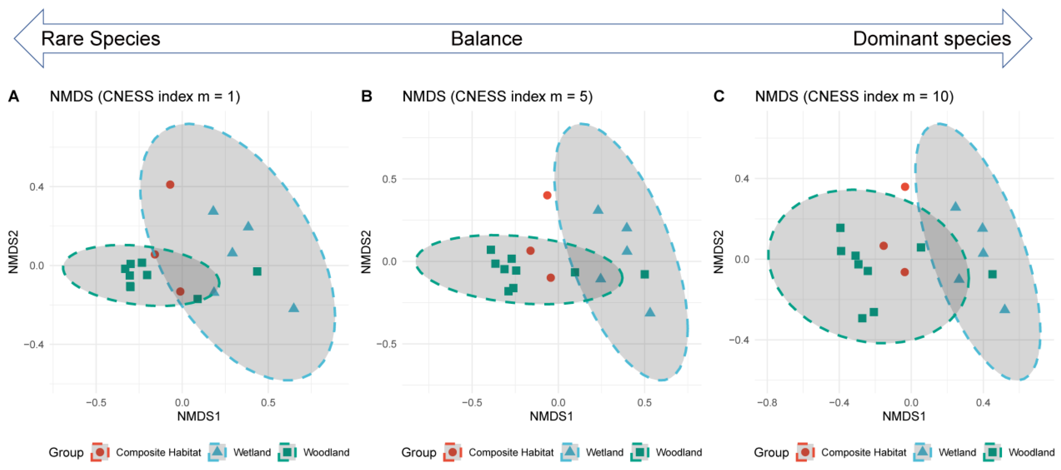
3.2.2. Beta Diversity

The non-metric multidimensional scaling (NMDS) analysis was performed using the Chord-Normalized Expected Species Shared (CNESS) index with m values of 1, 5, and 10 to evaluate the similarity among the three habitat groups: Composite Habitat, Wetland, and Woodland. The stress values for the NMDS configurations were 0.104992 for m = 1, 0.1066703 for m = 5, and 0.1146135 for m = 10, indicating that the ordinations provided a good representation of the data with low stress levels. The NMDS ordination with m = 1 (Figure 4A), which emphasized the presence of rare species, showed that the Composite Habitat and Wetland groups had some overlap, while the Woodland group formed a distinct cluster. In the NMDS ordination with m = 5 (Figure 4B), balancing the contributions of both rare and common species, the Composite Habitat and Wetland groups exhibited more overlap compared to the m = 1 configuration, while the Woodland group remained distinct. The NMDS ordination with m = 10 (Figure 4C), emphasizing the presence of common species, revealed increased overlap between the Composite Habitat and Wetland groups. The distinction between these two groups and the Woodland group became less pronounced.
The PERMANOVA analysis also revealed significant differences in community composition among the habitat groups (Composite Habitat, Wetland, and Woodland) for all CNESS index m values (1, 5, and 10). For m = 1 (F = 2.3523, R2 = 0.25152, p = 0.005), m = 5 (F = 2.391, R2 = 0.2546, p = 0.006), and m = 10 (F = 2.3251, R2 = 0.24934, p = 0.004), the results consistently showed that the habitat groups had significantly different community compositions. The differences were slightly more pronounced when considering a balance of rare and common species (m = 5).
The Indicator Species Analysis (IndVal) revealed that the Wetland habitat contains the most unique species. Significant indicator species with strong associations include Lanius schach (Long-Tailed Shrike) with IndVal = 0.821 and p = 0.004, Motacilla alba (White Wagtail) with IndVal = 0.739 and p = 0.009, and Egretta garzetta (Little Egret) with IndVal = 0.825 and p = 0.015. Marginally significant species include Charadrius dubius (Little Ringed Plover) with IndVal = 0.6 and p = 0.025 and Sturnus sericeus (Red-Billed Starling) with IndVal = 0.788 and p = 0.025. The Composite Habitat also has notable species, with Spizixos semitorques (Collared Finchbill) showing strong associations (IndVal = 0.930, p = 0.003) and Phylloscopus fuscatus (Dusky Warbler) (IndVal = 0.750, p = 0.009). The Woodland habitat had fewer unique species, with marginally significant species such as Pycnonotus sinensis (Light-Vented Bulbul) (IndVal = 0.274, p = 0.073) and Aegithalos concinnus (Black-Throated Bushtit) (IndVal = 0.188, p = 0.075).
Overall, the analysis indicates that the Wetland habitat supports the highest number of both strongly and marginally significant indicator species. This suggests that the Wetland environment is more likely to contain species that are uniquely adapted to this habitat, making it a critical area for biodiversity conservation. In contrast, the and Woodland support fewer unique species, with more marginally significant associations observed. This highlights the importance of Wetland habitats in maintaining biodiversity and supporting species with specific habitat requirements.

3.3. Bird Diversity in Green Corridor Response to Landscape Pattern

3.3.1. Diversity Response to Landscape Configuration

As shown in Table 2, we conducted a series of mixed models to analyze the effects of various landscape configuration metrics on species richness, abundance, Shannon diversity, and Simpson diversity, using landscape configuration indices as predictors. The generalized linear mixed model (GLMM) for species richness indicated a significant baseline level with an intercept estimate of 59.69 (SE = 10.59, df = 14.55, p < 0.001). The landscape index PARA_SD (patch area standard deviation) was found to have a significant negative effect on species richness (estimate = −227.40, SE = 63.26, df = 13.17, p = 0.0032). The generalized linear mixed model (GLMM) for abundance, fitted with a Poisson distribution, revealed a significant baseline abundance with an intercept estimate of 8.812 (SE = 0.501, z = 17.604, p < 0.001). Significant predictors included DIVISION (landscape division index) (estimate = −5.283, SE = 0.278, z = −19.024, p < 0.001), PD (patch density) (estimate = 0.008, SE = 0.001, z = 8.182, p < 0.001), PR (patch richness) (estimate = 0.041, SE = 0.006, z = 6.606, p < 0.001), the SHDI (Shannon diversity index) (estimate = 1.369, SE = 0.110, z = 12.491, p < 0.001), and PARA_SD (patch area standard deviation) (estimate = −18.56, SE = 1.454, z = −12.763, p < 0.001). The LMM for Shannon diversity indicated a significant baseline diversity with an intercept estimate of 3.714 (SE = 0.613, df = 14.69, p < 0.001). The predictor PR (patch richness) had a significant negative effect on Shannon diversity (estimate = −0.065, SE = 0.026, df = 13.56, p = 0.0249). The LMM for Simpson diversity revealed a significant baseline diversity with an intercept estimate of 1.184 (SE = 0.183, df = 15, p < 0.001). The predictor PR (patch richness) also had a significant negative effect on Simpson diversity (estimate = −0.017, SE = 0.008, df = 15, p = 0.0457). These results highlight the varying impacts of landscape indices on different biodiversity metrics. Specifically, PARA_SD (patch area standard deviation) negatively affects both species richness and abundance, while PR (patch richness) consistently demonstrates a negative relationship with both Shannon and Simpson diversity indices. These findings underscore the importance of considering multiple landscape metrics when assessing biodiversity outcomes in ecological landscapes.
To understand the relationship between bird community composition and landscape composition indices, we employed redundancy analysis using different m values of the CNESS index (m = 1, 5, and 10). The analyses revealed varying degrees of explained variation and highlighted key landscape metrics impacting bird communities, with m values indicating the focus on rare species (m = 1) to dominant species (m = 10), as shown in Table 3.
For m = 1, which emphasizes rare species, the total explained variation was 12.8%. The most significant positive contributor was patch area standard deviation (48.12%), followed by patch richness (21.80%) and the Shannon diversity index (13.36%). Negative contributors such as the aggregation index and edge density had minimal impacts, indicating that the variability in patch size and the richness of patches were crucial for the rare species within the bird community. When m = 5, reflecting a balanced focus between rare and common species, the total explained variation slightly increased to 13.1%. Patch area standard deviation remained a dominant positive contributor (44.66%), with patch richness (17.94%) and Shannon diversity index (14.27%) also contributing significantly. The influence of negative contributors like aggregation index and edge density was less pronounced, suggesting that the overall diversity and evenness of the landscape play a significant role in shaping the bird community when considering both rare and common species. For m = 10, which focuses on dominant species, the total explained variation slightly decreased to 12.3%. Patch area standard deviation was again the leading positive contributor (38.86%), followed by patch richness, Shannon diversity index, and patch density. The minimal impact of negative contributors like aggregation index and edge density indicates that for dominant species, the variability in patch size and landscape diversity are still important but slightly less influential compared to their impact on rare species.
In summary, the analyses consistently indicated that patch area standard deviation is a crucial factor in explaining bird community composition across different m values, emphasizing the importance of patch area variability. Additionally, metrics such as patch richness, Shannon diversity index, and Shannon evenness index highlighted the significance of landscape diversity and evenness in shaping bird communities. The variations in explained total variation across different m values reflect the robust influence of these landscape metrics on both rare and dominant species within bird communities.

3.3.2. Diversity Response to Landscape Composition

The study also investigates the relationship between bird diversity along urban greenways and the landscape composition within a 1000 m radius, as shown in Table 4. The species richness model reveals that certain land use types have significant effects on bird species richness. Specifically, park and green space, and public facility land are positively correlated with species richness, with estimates of 60.187 and 434.045, respectively, indicating that these areas support higher bird diversity. However, facility agricultural land shows a negative but non-significant impact on species richness with an estimate of −152.728.
In contrast, the species abundance model includes various land use types and their significant effects on bird abundance. Variables such as rural roads and canals show strong influences, with rural roads having a significantly negative impact (estimate = −32,449.6) and canals a significantly positive impact (estimate = 10,903.1). Other land use types, like park and green space, and public facility land, also show significant positive effects on bird abundance.
Despite these findings, the analyses using Shannon and Simpson indices did not yield optimal models for bird diversity. This suggests that the landscape composition indices do not significantly impact bird diversity along urban greenways. The lack of a significant relationship between these indices and bird diversity implies that other factors, potentially beyond the scope of landscape composition, might play more critical roles in influencing bird diversity in these urban settings.
To understand the relationship between bird community composition and landscape composition indices, we employed a redundancy analysis using different m values of the CNESS index (m = 1, 5, and 10). The analyses revealed varying degrees of explained variation and highlighted key landscape metrics impacting bird communities, with m values indicating the focus on rare species (m = 1) to dominant species (m = 10), as shown in Table 5. For m = 1, which emphasized rare species, the total explained variation was 37.2%. The most significant positive contributor was facility agricultural land (21.16%), followed by adjustable arbor forests (23.74%) and other grasslands (13.39%). Negative contributors such as bare rocky gravel land (−0.51%) and orchards (−0.08%) had minimal impacts, indicating that the variability in land use types and the richness of specific landscapes were crucial for the rare species within the bird community. When m = 5, reflecting a balanced focus between rare and common species, the total explained variation slightly decreased to 29.9%. Facility agricultural land remained a dominant positive contributor (26.56%), with adjustable arbor forests (35.02%) and other grasslands (11.57%) also contributing significantly. The influence of negative contributors like urban residential land (−1.20%) and orchards (−4.01%) was more pronounced, suggesting that the overall diversity and evenness of the landscape play a significant role in shaping the bird community when considering both rare and common species. For m = 10, which focused on dominant species, the total explained variation further decreased to 21.8%. Adjustable arbor forests was the leading positive contributor (53.12%), followed by facility agricultural land (33.03%), and other grasslands (10.09%). The minimal impact of negative contributors like urban residential land (−6.15%) and orchards (−8.49%) indicates that for dominant species, the variability in specific land use types and landscape diversity are still important but slightly less influential compared to their impact on rare species.
In summary, the analyses consistently indicated that adjustable arbor forests and facility agricultural land are crucial factors in explaining bird community composition across different m values, emphasizing the importance of land use variability. Additionally, metrics such as other grasslands and tea plantations highlighted the significance of landscape diversity and evenness in shaping bird communities. The variations in explained total variation across different m values reflect the robust influence of these landscape metrics on both rare and dominant species within bird communities.

4. Discussion

4.1. Bird Diversity Distribution in Urban Greenways

Investigating the spatial heterogeneity of bird community distribution in urban greenways is essential for understanding and optimizing their ecological functions. Our study results indicate that species richness in wetland habitats is significantly higher than in forest and mixed habitats, suggesting that wetlands provide stronger support for bird communities in this region. This disparity highlights the significant differences in habitat and resource provision among various habitat types. Wetlands, with their diverse vegetation structure and abundant food resources, are often considered crucial habitats and migration corridors for birds. These wetlands offer a wealth of ecological niches, allowing bird species with varying ecological requirements to coexist, thereby enhancing overall biodiversity.
The presence of mixed habitats may indicate the interspersion and mixture of multiple habitat types, providing a variety of nesting environments and food resources for birds. Mixed habitats not only support a greater number of species but also attract birds with higher specific habitat requirements [41,42]. In contrast, forest habitats exhibit relatively lower species richness and diversity, possibly due to greater fragmentation and human disturbance in urban forests, which degrade habitat quality and inhibit the survival of specialized species [43]. Additionally, the enclosed nature and uniform vegetation structure of forests may limit food sources and living spaces for birds [44]. In our study, no significant endemic species were found in forest habitats, reflecting their lack of ecological diversity and insufficient support for bird diversity [45].
However, why does an ecological facility like an urban greenway exhibit spatial heterogeneity in bird distribution? Based on the experimental results, the role of greenways in bird passage likely occurs over short distances, with certain permeability between different habitats, though this permeability is relatively limited [16,46]. This suggests that while greenways can facilitate some movement of birds between habitats, their effectiveness may be restricted [11]. This limitation may arise because the design and structure of greenways do not fully meet the passage requirements of all bird species, especially those with high habitat quality demands. Additionally, the habitat filtering function of greenways also reflects the limitation of human disturbance [47]. By restricting human activity pathways and incorporating designs like elevated paths that preserve original habitats, greenways can potentially reduce human interference [48]. This design not only helps to lessen direct disturbances to birds but also preserves critical habitats, providing a more stable and secure environment for birds. These measures can reduce birds’ sensitivity to human activities, thereby increasing their chances of survival and reproduction within the greenway.
Nonetheless, this study has several primary limitations. Firstly, the research was conducted only during the autumn and winter seasons, not covering the year-round variations in bird diversity, which may lead to an incomplete understanding of the annual ecological dynamics. Future research should include multi-center, long-term systematic observations, especially targeted pathway analysis experiments, to validate these findings. Additionally, although various habitat types were considered, a detailed analyses of microhabitat characteristics and more complex human disturbance factors were lacking, which could significantly impact bird community distribution. Future studies should expand the temporal and spatial scope, refine habitat characteristic analyses, and employ advanced technologies for more detailed ecological monitoring to further validate and extend the findings of this study.

4.2. Impact of Landscape Patterns on Bird Diversity in Greenways

This study aims to explore the response of bird diversity in green corridors to landscape patterns and to analyze the impact of landscape configuration and composition on bird communities. Green corridors play a crucial role in urban ecosystems, providing essential habitats and migration pathways for various species [49,50]. Understanding how landscape patterns affect bird diversity can provide scientific evidence for urban planning and biodiversity conservation, helping to design more effective ecological corridors to maintain and enhance biodiversity in urban areas. The results show that the patch area standard deviation (PARA_SD) has a significant negative impact on species richness and abundance, while patch richness (PR) negatively affects Shannon diversity and Simpson diversity. Redundancy analysis using the CNESS index indicates that PARA_SD plays a key role in explaining the distribution of rare and common species. Additionally, parks, green spaces, and public facilities positively impact species richness and abundance.
These results are consistent with previous studies that emphasize the importance of habitat diversity and continuity in maintaining bird diversity. Many studies have shown that landscape fragmentation negatively impacts biodiversity [51,52], while habitat continuity and diversity help support more species. The positive impact of parks, green spaces, and public facilities on bird diversity also aligns with previous findings, indicating that these areas provide rich resources and suitable habitats that support high levels of bird diversity [53]. The negative impact of PARA_SD on species richness and abundance can be explained through the dispersal process of species within corridors. Habitat fragmentation hinders the movement and dispersal of species within corridors [54,55], limiting their ability to utilize different habitats. According to niche theory, species require suitable habitats to meet their survival and reproductive needs, and fragmented habitats often fail to provide continuous suitable habitats, leading to a decline in species diversity and abundance [56]. The negative impact of PR on Shannon and Simpson diversity further supports this conclusion. While high patch richness might indicate diverse habitat types, the dispersal and fragmentation of these habitats make it difficult for species to effectively utilize all available habitats, thereby reducing overall species evenness and diversity [57].
Parks, green spaces, and public facilities positively influence bird species richness and abundance, which is consistent with habitat preference and niche theory. These areas provide rich resources and diverse habitats, reduce human disturbance, and create favorable habitat conditions that help maintain high levels of bird diversity [58,59]. According to neutral theory, these areas may also offer a larger species pool, increasing the chances of random dispersal and thus enhancing species richness [60]. Although facility agricultural land is typically considered detrimental to biodiversity, this study found it to have a positive effect on certain bird communities. This might be because these areas provide diverse food resources and habitats suitable for certain bird species. According to both neutral theory and niche theory, these areas might meet the unique habitat requirements of specific species, increasing their presence and distribution.
Based on the results of this study, the following hypotheses can be proposed: increasing habitat diversity and continuity in landscapes will help enhance bird diversity and community stability and reducing habitat fragmentation and human disturbance will help protect bird habitats and improve the survival and reproductive success of bird populations. The findings of this study provide important scientific evidence for landscape management and biodiversity conservation. These results highlight the need to consider habitat diversity and continuity in landscape planning to promote the conservation and maintenance of bird diversity. Future research could further investigate the specific mechanisms by which different types of landscapes and habitats affect bird diversity, as well as the roles of other environmental factors. Future studies should include more samples from different regions and landscape types to validate the generality of these results and deeply analyze the specific impacts of facility agricultural land on bird diversity. Additionally, examining the effects of climate change and human activities on bird diversity will help us comprehensively understand the multiple factors influencing bird communities and provide a basis for developing more comprehensive conservation strategies.
As a case study and part of a systematic research effort, this paper does not address the patterns of bird diversity and functional characteristics under a broader range of environmental conditions. The variation in different types of birds, such as their diet, body length, and functional divisions, are key elements for understanding ecological patterns. Future research will focus on multicenter studies to explore these patterns. We plan to conduct similar experiments in various cities across Zhejiang Province, distinguishing the urbanization gradients to further validate our findings.

4.3. Implications for Future Urban Greenway Construction

Modern urban green space design increasingly emphasizes enhancing ecological connectivity through green corridors [61]. However, existing design methods lack robust evidence and rely heavily on simplified ecological models and parameter evaluations, such as the minimum cost resistance (MCR) method and circuit theory [62]. These methods often fail to accurately reflect real-world conditions, as evidenced by our findings which indicate that animals may use corridors in ways that differ from traditional assumptions. The study reveals that most species use corridors primarily for short-range passage, akin to a “short-distance train.” Therefore, a deeper understanding of the ecological processes within corridors is essential, providing crucial evidence for design.
The essence of corridors lies in two aspects: enhancing ecological connectivity by linking existing habitats and creating certain isolation effects [63]. Temporally and spatially, the establishment of artificial corridors is part of landscape dynamics, altering landscape structure and influencing the generation and intensity of disturbances. While corridors enhance species movement between different habitats, they may also introduce edge effects and new sources of disturbance, affecting ecological processes and biodiversity [64].
The way animals use corridors might differ from traditional views, highlighting the necessity of introducing microhabitats [65]. Particularly in densely vegetated environments (such as forests), effective connectivity design can significantly improve biodiversity levels. Future designs should consider increasing habitat heterogeneity to enhance overall ecosystem stability and resilience [66]. For example, integrating various vegetation types, restoring wetlands, and constructing bio-retention areas within greenways can increase habitat complexity and support a wider range of species. From a habitat-scale perspective, designers should incorporate diverse habitat types, such as wetlands, forests, and mixed habitats, to meet the ecological needs of different species.
Moreover, there is a significant negative correlation between landscape fragmentation and both bird species richness and Shannon diversity index. Thus, designers should reduce landscape fragmentation and increase habitat continuity and integrity to enhance ecological connectivity [67]. In densely vegetated habitats (such as forests), creating small open areas or “ecological nodes” can promote biodiversity. These microhabitats provide additional resources and refuges, enhancing overall ecological function. By leveraging geographic information Systems (GISs) and remote sensing technologies, designers can simulate the ecological impacts of different design scenarios, allowing for a better understanding and evaluation of the effects on ecological connectivity and biodiversity. Additionally, long-term ecological monitoring mechanisms should be implemented, using collected data to continually optimize greenway design and management strategies, ensuring sustained ecological functionality. From a landscape-scale perspective, the effects of the corridor itself and its surrounding landscape features are critical considerations in design. Reducing landscape fragmentation and increasing habitat continuity and integrity are essential for improving biodiversity. Future research should explore how optimizing landscape structure and function can enhance the ecological benefits of greenways.

5. Conclusions

This study elucidates the primary patterns and driving mechanisms of biodiversity distribution within urban greenways by revealing the heterogeneity in bird diversity distribution and the critical role of landscape configuration in species passage and biodiversity distribution disparities. The findings highlight the importance of habitat heterogeneity in maintaining diverse habitat resources and ecological niches, as well as the potential preferences in biodiversity distribution. The results also suggest that most birds’ use of corridors may be primarily limited to small-scale passage, underscoring the importance of microhabitat design and diverse habitat configurations. Furthermore, the study found that enhancing connectivity through reducing landscape fragmentation and increasing habitat continuity is essential for improving ecological connectivity and biodiversity. However, these conclusions require further experimental validation. Future research should continue to investigate the specific impacts of different landscape characteristics on bird communities and develop more comprehensive and innovative design methods to achieve the goals of urban biodiversity conservation and sustainable development. By continually optimizing and validating design strategies, urban greenways can provide richer ecosystem services and contribute to the sustainable development of cities.

Author Contributions

Conceptualization, W.X., W.H. and Y.T.; methodology, W.W. and Y.T.; software, W.H.; validation, investigation, W.H. and W.W.; resources, W.X., W.W. and Y.T.; data curation, W.W. and Y.T.; writing—original draft preparation, L.H. and W.W.; writing—review and editing, W.X., W.W. and Y.T.; visualization, W.W.; supervision, W.X.; project administration, W.X., W.W. and Y.T. All authors have read and agreed to the published version of the manuscript.

Funding

This research was funded by the Zhejiang A&F University Research Development Foundation (Project No. 2021LFR054) and the Natural Science Foundation of Zhejiang Province (LGN20C160003 and LGN19E080002).

Data Availability Statement

Dataset available on request from the authors.

Acknowledgments

We would like to express our gratitude to Diya Deng for her support in sampling. We also thank the Qingshan Lake National Forest Management Bureau for their assistance with policies and sampling. Special thanks go to Jian Chen for his valuable suggestions on sampling and to Liujie for his invaluable support in the identification process.

Conflicts of Interest

The authors declare no conflicts of interest.

References

  1. Xu, X.; Xie, Y.; Qi, K.; Luo, Z.; Wang, X. Detecting the response of bird communities and biodiversity to habitat loss and fragmentation due to urbanization. Sci. Total Environ. 2018, 624, 1561–1576. [Google Scholar] [CrossRef] [PubMed]
  2. Reis, E.; López-Iborra, G.M.; Pinheiro, R.T. Changes in bird species richness through different levels of urbanization: Implications for biodiversity conservation and garden design in Central Brazil. Landsc. Urban Plan. 2012, 107, 31–42. [Google Scholar] [CrossRef]
  3. Chen, R.; Carruthers-Jones, J.; Carver, S.; Wu, J. Constructing urban ecological corridors to reflect local species diversity and conservation objectives. Sci. Total Environ. 2024, 907, 167987. [Google Scholar] [CrossRef] [PubMed]
  4. Gaston, K.J.; Cox, D.T.; Canavelli, S.B.; García, D.; Hughes, B.; Maas, B.; Martínez, D.; Ogada, D.; Inger, R. Population abundance and ecosystem service provision: The case of birds. Bioscience 2018, 68, 264–272. [Google Scholar] [CrossRef] [PubMed]
  5. Aronson, M.F.; Lepczyk, C.A.; Evans, K.L.; Goddard, M.A.; Lerman, S.B.; MacIvor, J.S.; Nilon, C.H.; Vargo, T. Biodiversity in the city: Key challenges for urban green space management. Front. Ecol. Environ. 2017, 15, 189–196. [Google Scholar] [CrossRef]
  6. Wood, E.; Harsant, A.; Dallimer, M.; Cronin De Chavez, A.; McEachan, R.R.; Hassall, C. Not all green space is created equal: Biodiversity predicts psychological restorative benefits from urban green space. Front. Psychol. 2018, 9, 2320. [Google Scholar] [CrossRef]
  7. Kong, F.; Yin, H.; Nakagoshi, N.; Zong, Y. Urban green space network development for biodiversity conservation: Identification based on graph theory and gravity modeling. Landsc. Urban Plan. 2010, 95, 16–27. [Google Scholar] [CrossRef]
  8. Angold, P.G.; Sadler, J.P.; Hill, M.O.; Pullin, A.; Rushton, S.; Austin, K.; Small, E.; Wood, B.; Wadsworth, R.; Sanderson, R. Biodiversity in urban habitat patches. Sci. Total Environ. 2006, 360, 196–204. [Google Scholar] [CrossRef]
  9. Horte, O.S.; Eisenman, T.S. Urban greenways: A systematic review and typology. Land 2020, 9, 40. [Google Scholar] [CrossRef]
  10. Chin, E.Y.; Kupfer, J.A. Identification of environmental drivers in urban greenway communities. Urban For. Urban Green. 2020, 47, 126549. [Google Scholar] [CrossRef]
  11. Lynch, A.J. Creating effective urban greenways and stepping-stones: Four critical gaps in habitat connectivity planning research. J. Plan. Lit. 2019, 34, 131–155. [Google Scholar] [CrossRef]
  12. Klingbeil, B.T.; Willig, M.R. Community assembly in temperate forest birds: Habitat filtering, interspecific interactions and priority effects. Evol. Ecol. 2016, 30, 703–722. [Google Scholar]
  13. Carlier, J.; Moran, J. Landscape typology and ecological connectivity assessment to inform Greenway design. Sci. Total Environ. 2019, 651, 3241–3252. [Google Scholar] [CrossRef] [PubMed]
  14. Bueno, J.A.; Tsihrintzis, V.A.; Alvarez, L. South Florida greenways: A conceptual framework for the ecological reconnectivity of the region. Landsc. Urban Plan. 1995, 33, 247–266. [Google Scholar] [CrossRef]
  15. Buelow, C.; Sheaves, M. A birds-eye view of biological connectivity in mangrove systems. Estuar. Coast. Shelf Sci. 2015, 152, 33–43. [Google Scholar] [CrossRef]
  16. Von Haaren, C.; Reich, M. The German way to greenways and habitat networks. Landsc. Urban Plan. 2006, 76, 7–22. [Google Scholar]
  17. Thiele, T.; Jeltsch, F.; Blaum, N. Importance of woody vegetation for foraging site selection in the Southern Pied Babbler (Turdoides bicolor) under two different land use regimes. J. Arid. Environ. 2008, 72, 471–482. [Google Scholar] [CrossRef]
  18. Moudrý, V.; Moudrá, L.; Barták, V.; Bejček, V.; Gdulová, K.; Hendrychová, M.; Moravec, D.; Musil, P.; Rocchini, D.; Šťastný, K. The role of the vegetation structure, primary productivity and senescence derived from airborne LiDAR and hyperspectral data for birds diversity and rarity on a restored site. Landsc. Urban Plan. 2021, 210, 104064. [Google Scholar] [CrossRef]
  19. Xi, C.; Chi, Y.; Qian, T.; Zhang, W.; Wang, J. Simulation of Human Activity Intensity and Its Influence on Mammal Diversity in Sanjiangyuan National Park, China. Sustainability 2020, 12, 4601. [Google Scholar] [CrossRef]
  20. Semenchuk, P.; Plutzar, C.; Kastner, T.; Matej, S.; Bidoglio, G.; Erb, K.; Essl, F.; Haberl, H.; Wessely, J.; Krausmann, F. Relative effects of land conversion and land-use intensity on terrestrial vertebrate diversity. Nat. Commun. 2022, 13, 615. [Google Scholar] [CrossRef]
  21. Rich, A.C.; Dobkin, D.S.; Niles, L.J. Defining forest fragmentation by corridor width: The influence of narrow forest-dividing corridors on forest-nesting birds in southern New Jersey. Conserv. Biol. 1994, 8, 1109–1121. [Google Scholar] [CrossRef]
  22. Laiolo, P. Spatial and seasonal patterns of bird communities in Italian agroecosystems. Conserv. Biol. 2005, 19, 1547–1556. [Google Scholar] [CrossRef]
  23. Tzortzakaki, O.; Kati, V.; Kassara, C.; Tietze, D.T.; Giokas, S. Seasonal patterns of urban bird diversity in a Mediterranean coastal city: The positive role of open green spaces. Urban Ecosyst. 2018, 21, 27–39. [Google Scholar] [CrossRef]
  24. St, L.; Wold, S. Analysis of variance (ANOVA). Chemom. Intell. Lab. Syst. 1989, 6, 259–272. [Google Scholar]
  25. Shapiro, S.S.; Wilk, M.B. An analysis of variance test for normality (complete samples). Biometrika 1965, 52, 591–611. [Google Scholar] [CrossRef]
  26. Arsham, H.; Lovric, M. Bartlett’s Test. Int. Encycl. Stat. Sci. 2011, 2, 20–23. [Google Scholar]
  27. Williams, L.J.; Abdi, H. Fisher’s least significant difference (LSD) test. Encycl. Res. Des. 2010, 218, 840–853. [Google Scholar]
  28. Zou, Y.; Axmacher, J.C. The Chord-Normalized Expected Species Shared (CNESS)-distance represents a superior measure of species turnover patterns. Methods Ecol. Evol. 2020, 11, 273–280. [Google Scholar] [CrossRef]
  29. Taguchi, Y.; Oono, Y. Relational patterns of gene expression via non-metric multidimensional scaling analysis. Bioinformatics 2005, 21, 730–740. [Google Scholar] [CrossRef]
  30. Anderson, M.J. Permutational multivariate analysis of variance (PERMANOVA). Wiley Statsref Stat. Ref. Online 2014, 1–15. [Google Scholar] [CrossRef]
  31. De Cáceres, M.; Legendre, P.; Moretti, M. Improving indicator species analysis by combining groups of sites. Oikos 2010, 119, 1674–1684. [Google Scholar] [CrossRef]
  32. Bates, D.; Mächler, M.; Bolker, B.; Walker, S. Fitting linear mixed-effects models using lme4. arXiv 2014, arXiv:1406.5823. [Google Scholar]
  33. O’Brien, R.M. A caution regarding rules of thumb for variance inflation factors. Qual. Quant. 2007, 41, 673–690. [Google Scholar] [CrossRef]
  34. Whittingham, M.J.; Stephens, P.A.; Bradbury, R.B.; Freckleton, R.P. Why do we still use stepwise modelling in ecology and behaviour? J. Anim. Ecol. 2006, 75, 1182–1189. [Google Scholar] [CrossRef]
  35. McArdle, B.H.; Anderson, M.J. Fitting multivariate models to community data: A comment on distance-based redundancy analysis. Ecology 2001, 82, 290–297. [Google Scholar] [CrossRef]
  36. R Core Team. R: A Language and Environment for Statistical Computing; R Core Team: Vienna, Austria, 2023. [Google Scholar]
  37. Oksanen, J.; Blanchet, F.G.; Kindt, R.; Legendre, P.; Minchin, P.R.; O Hara, R.B.; Simpson, G.L.; Solymos, P.; Stevens, M.H.H.; Wagner, H. Package ‘vegan’. Community Ecol. Package Version 2013, 2, 321–326. [Google Scholar]
  38. de Mendiburu, F.; de Mendiburu, M.F. Package ‘agricolae’. R Package Version 2019, 1, 1143–1149. [Google Scholar]
  39. Kuznetsova, A.; Brockhoff, P.B.; Christensen, R.H.B. lmerTest package: Tests in linear mixed effects models. J. Stat. Softw. 2017, 82. [Google Scholar] [CrossRef]
  40. Lai, J.; Zou, Y.; Zhang, J.; Peres Neto, P.R. Generalizing hierarchical and variation partitioning in multiple regression and canonical analyses using the rdacca. hp R package. Methods Ecol. Evol. 2022, 13, 782–788. [Google Scholar] [CrossRef]
  41. Peh, K.S.; De Jong, J.; Sodhi, N.S.; Lim, S.L.; Yap, C.A. Lowland rainforest avifauna and human disturbance: Persistence of primary forest birds in selectively logged forests and mixed-rural habitats of southern Peninsular Malaysia. Biol. Conserv. 2005, 123, 489–505. [Google Scholar] [CrossRef]
  42. Andren, H. Effects of habitat fragmentation on birds and mammals in landscapes with different proportions of suitable habitat: A review. Oikos 1994, 71, 355–366. [Google Scholar] [CrossRef]
  43. Kang, W.; Minor, E.S.; Park, C.; Lee, D. Effects of habitat structure, human disturbance, and habitat connectivity on urban forest bird communities. Urban Ecosyst. 2015, 18, 857–870. [Google Scholar] [CrossRef]
  44. Deppe, J.L.; Rotenberry, J.T. Scale-dependent habitat use by fall migratory birds: Vegetation structure, floristics, and geography. Ecol. Monogr. 2008, 78, 461–487. [Google Scholar] [CrossRef]
  45. Buron, R.; Hostetler, M.E.; Andreu, M. Urban forest fragments vs. residential neighborhoods: Urban habitat preference of migratory birds. Landsc. Urban Plan. 2022, 227, 104538. [Google Scholar] [CrossRef]
  46. Ramos, D.L.; Pizo, M.A.; Ribeiro, M.C.; Cruz, R.S.; Morales, J.M.; Ovaskainen, O. Forest and connectivity loss drive changes in movement behavior of bird species. Ecography 2020, 43, 1203–1214. [Google Scholar] [CrossRef]
  47. Eyster, H.N.; Srivastava, D.S.; Kreitzman, M.; Chan, K.M. Functional traits and metacommunity theory reveal that habitat filtering and competition maintain bird diversity in a human shared landscape. Ecography 2022, 2022, e6240. [Google Scholar] [CrossRef]
  48. Bryant, M.M. Urban landscape conservation and the role of ecological greenways at local and metropolitan scales. Landsc. Urban Plan. 2006, 76, 23–44. [Google Scholar] [CrossRef]
  49. Vergnes, A.; Le Viol, I.; Clergeau, P. Green corridors in urban landscapes affect the arthropod communities of domestic gardens. Biol. Conserv. 2012, 145, 171–178. [Google Scholar] [CrossRef]
  50. Beaugeard, E.; Brischoux, F.; Angelier, F. Green infrastructures and ecological corridors shape avian biodiversity in a small French city. Urban Ecosyst. 2021, 24, 549–560. [Google Scholar] [CrossRef]
  51. Fahrig, L. Effects of habitat fragmentation on biodiversity. Annu. Rev. Ecol. Evol. Syst. 2003, 34, 487–515. [Google Scholar] [CrossRef]
  52. Fletcher Jr, R.J.; Didham, R.K.; Banks-Leite, C.; Barlow, J.; Ewers, R.M.; Rosindell, J.; Holt, R.D.; Gonzalez, A.; Pardini, R.; Damschen, E.I. Is habitat fragmentation good for biodiversity? Biol. Conserv. 2018, 226, 9–15. [Google Scholar] [CrossRef]
  53. Nielsen, A.B.; Van Den Bosch, M.; Maruthaveeran, S.; van den Bosch, C.K. Species richness in urban parks and its drivers: A review of empirical evidence. Urban Ecosyst. 2014, 17, 305–327. [Google Scholar] [CrossRef]
  54. Damschen, E.I.; Baker, D.V.; Bohrer, G.; Nathan, R.; Orrock, J.L.; Turner, J.R.; Brudvig, L.A.; Haddad, N.M.; Levey, D.J.; Tewksbury, J.J. How fragmentation and corridors affect wind dynamics and seed dispersal in open habitats. Proc. Natl. Acad. Sci. USA 2014, 111, 3484–3489. [Google Scholar] [CrossRef] [PubMed]
  55. Bennett, A.F. Habitat corridors and the conservation of small mammals in a fragmented forest environment. Landsc. Ecol. 1990, 4, 109–122. [Google Scholar] [CrossRef]
  56. Gehring, T.M.; Swihart, R.K. Body size, niche breadth, and ecologically scaled responses to habitat fragmentation: Mammalian predators in an agricultural landscape. Biol. Conserv. 2003, 109, 283–295. [Google Scholar] [CrossRef]
  57. Rybicki, J.; Abrego, N.; Ovaskainen, O. Habitat fragmentation and species diversity in competitive communities. Ecol. Lett. 2020, 23, 506–517. [Google Scholar] [CrossRef] [PubMed]
  58. Schütz, C.; Schulze, C.H. Functional diversity of urban bird communities: Effects of landscape composition, green space area and vegetation cover. Ecol. Evol. 2015, 5, 5230–5239. [Google Scholar] [CrossRef] [PubMed]
  59. Tryjanowski, P.; Morelli, F.; Mikula, P.; Krištín, A.; Indykiewicz, P.; Grzywaczewski, G.; Kronenberg, J.; Jerzak, L. Bird diversity in urban green space: A large-scale analysis of differences between parks and cemeteries in Central Europe. Urban For. Urban Green. 2017, 27, 264–271. [Google Scholar] [CrossRef]
  60. May, F.; Giladi, I.; Ziv, Y.; Jeltsch, F. Dispersal and diversity–unifying scale-dependent relationships within the neutral theory. Oikos 2012, 121, 942–951. [Google Scholar]
  61. Zhang, Z.; Meerow, S.; Newell, J.P.; Lindquist, M. Enhancing landscape connectivity through multifunctional green infrastructure corridor modeling and design. Urban For. Urban Green. 2019, 38, 305–317. [Google Scholar]
  62. Yang, C.; Guo, H.; Huang, X.; Wang, Y.; Li, X.; Cui, X. Ecological network construction of a national park based on MSPA and MCR models: An example of the proposed national parks of “Ailaoshan-Wuliangshan” in China. Land 2022, 11, 1913. [Google Scholar] [CrossRef]
  63. Beier, P.; Noss, R.F. Do habitat corridors provide connectivity? Conserv. Biol. 1998, 12, 1241–1252. [Google Scholar]
  64. Haddad, N.M.; Brudvig, L.A.; Damschen, E.I.; Evans, D.M.; Johnson, B.L.; Levey, D.J.; Orrock, J.L.; Resasco, J.; Sullivan, L.L.; Tewksbury, J.J. Potential negative ecological effects of corridors. Conserv. Biol. 2014, 28, 1178–1187. [Google Scholar] [CrossRef] [PubMed]
  65. Hoyle, M. When corridors work: Insights from a microecosystem. Ecol. Model. 2007, 202, 441–453. [Google Scholar]
  66. Oliver, T.; Roy, D.B.; Hill, J.K.; Brereton, T.; Thomas, C.D. Heterogeneous landscapes promote population stability. Ecol. Lett. 2010, 13, 473–484. [Google Scholar] [CrossRef]
  67. Salviano, I.R.; Gardon, F.R.; Dos Santos, R.F. Ecological corridors and landscape planning: A model to select priority areas for connectivity maintenance. Landsc. Ecol. 2021, 36, 3311–3328. [Google Scholar] [CrossRef]
Figure 1. Locations of sampling points among study site.
Land 13 01192 g001
Figure 2. Some representative observation records of selected species. (A): Emberiza aureola; (B): Ciconia boyciana; (C): Anser albifrons; (D): Platalea leucorodia; (E): Aix galericulata; (F): Pycnonotus sinensis; (G): Anas poecilorhyncha; (H): Egretta garzetta; (I): Motacilla alba.
Land 13 01192 g002
Figure 3. Bird alpha diversity among different habitat types in Qingshan Lake Greenway. (A) Species richness; (B) Abundance (The test results after log transformation); (C) Shannon Diversity; (D) Simpson Diversity. Groups with the same letters are not significantly different from each other.
Land 13 01192 g003
Figure 4. MNDS among different habitat types in Qingshan Lake Greenway via CNESS index distance. (A) NMDS with m = 1 (Rare Species Scheme); (B) NMDS with m = 5 (Balance Scheme); (C) NMDS with m = 10 (Dominant Species Scheme).
Land 13 01192 g004
Table 1. ANOVA results for bird alpha diversity.
IndexDfSum SqMean SqFpSig
Species richness21016.1508.115<0.001***
Abundance (log-transformed)211.345.6715.03<0.001***
Shannon diversity20.5960.29791.2590.314
Simpson diversity20.012230.0061170.2890.753
Sig: ***: p < 0.001.
Table 2. Bird diversity response to landscape configuration indices in the autumn–winter season based on mixed model.
ModelVariableEstimateStd. Errort/z Valuep
Species Richness 1(Intercept)59.6910.595.636<0.001
PARA_SD−227.463.26−3.5950.0032
Abundance 1(Intercept)8.8120.50117.604<0.001
DIVISION−5.2830.278−19.024<0.001
PD0.0080.0018.182<0.001
PR0.0410.0066.606<0.001
SHDI1.3690.1112.491<0.001
PARA_SD−18.561.454−12.763<0.001
Shannon Diversity(Intercept)3.7140.6136.058<0.001
PR−0.0650.026−2.5210.0249
Simpson Diversity(Intercept)1.1840.1836.451<0.001
PR−0.0170.008−2.1790.0457
1 Poisson distribution family with log link function.
Table 3. Bird community composition response to landscape composition indices in the autumn–winter season based on mixed model.
Landscape Configuration IndexBird Community Composition with CNESS Index m = 1Bird Community Composition with CNESS Index m = 5Bird Community Composition with CNESS Index m = 10
Explanation Rate
(m = 1)
I.perc (%)
(m = 1)
Explanation Rate
(m = 5)
I.perc (%)
(m = 5)
Explanation Rate
(m = 10)
I.perc (%)
(m = 10)
AI−0.0081−6.33−0.0046−3.51−0.0008−0.65
DIVISION0.01138.830.00796.030.00282.28
ED−0.0086−6.72−0.0056−4.27−0.0022−1.79
PARA_SD0.061648.120.058544.660.047838.86
PD0.013410.470.016612.670.018414.96
PR0.027921.80.023517.940.019315.69
SHDI0.017113.360.018714.270.019515.85
SHEI0.012910.080.016212.370.017914.55
Table 4. Bird diversity response to landscape composition indices in the autumn–winter season based on mixed model.
ModelVariableEstimateStd. Errort/z Valuep
Species Richness 1(Intercept)14.7445.4812.690.041
Park and Green Space60.18721.3092.8240.0156
Public Facility Land434.045197.7182.1950.0494
Facility Agricultural Land−152.728100.708−1.5170.1561
Abundance 1(Intercept)−28130.3−0.2150.835323
Rural Road−32,449.63644.7−8.903<0.001
Park and Green Space5765.7806.67.148<0.001
Canal10,903.11919.15.681<0.001
Public Facility Land18,359.37515.52.4430.040384
Grassland−18,408.14574.8−4.0240.004
Facility Agricultural Land−10,1022608.8−3.8720.004726
Orchard−47962047.5−2.3420.04724
Bare Rock7402.41727.34.2860.002667
Shannon Diversity 2-
Simpson Diversity 2-
1 Poisson Distribution Family with log link function; 2 Analyses of Shannon and Simpson diversity indices did not yield optimal models.
Table 5. Bird community composition response to landscape configuration indices in the Autumn–Winter season based on mixed model.
Landscape
Configuration Index
Bird Community Composition with CNESS Index m = 1Bird Community Composition with CNESS Index m = 5Bird Community Composition with CNESS Index m = 10
Explanation Rate
(m = 1)
I.perc (%)
(m = 1)
Explanation Rate
(m = 5)
I.perc (%)
(m = 5)
Explanation Rate
(m = 10)
I.perc (%)
(m = 10)
Rural roads0.01724.620.01374.580.01135.18
Parks and green spaces0.039110.510.02568.560.01376.28
Ditches0.01373.680.00481.61−0.0036−1.65
Urban residential land0.00561.51−0.0036−1.2−0.0134−6.15
Tea plantations0.03359.010.02347.830.00843.85
Public facilities land0.00782.10.00260.87−0.0004−0.18
Other grasslands0.049813.390.034611.570.02210.09
Facility agricultural land0.078721.160.079426.560.07233.03
Orchards−0.0003−0.08−0.012−4.01−0.0185−8.49
Arbor forests0.0246.450.01916.390.01275.83
Reservoir water surface0.00220.59−0.0026−0.87−0.0065−2.98
Bare rocky gravel land−0.0019−0.51−0.0002−0.07−0.0007−0.32
Adjustable arbor forests0.088323.740.104735.020.115853.12
Total building land0.01453.90.00933.110.00492.25
Disclaimer/Publisher’s Note: The statements, opinions and data contained in all publications are solely those of the individual author(s) and contributor(s) and not of MDPI and/or the editor(s). MDPI and/or the editor(s) disclaim responsibility for any injury to people or property resulting from any ideas, methods, instructions or products referred to in the content.

